
Avalanche Hazard Modelling within the Kráľova Hoľa Area in the Low Tatra Mountains in Slovakia


Abstract
1. Introduction
- Due to the nature of the territory of the Kráľova hoľa area (relief conditions associated with the extent of the quaternary glaciation, land cover, morphometric conditions, etc.), we assumed there would be a greater occurrence of trigger areas and areas with a higher degree of avalanche threat on the northern slopes of the studied area.
- Compared to the various other studies carried out in Slovakia on a similar topic, we assumed there would be a lower area of trigger zones within the Kráľova hoľa area than in other Slovak mountains threatened by potential avalanche activity.
- We assumed there would be a combination of several factors entering into the assessment of avalanche endangerment—not just one dominant factor.
- We assumed that the design process of the avalanche cadastre based on results from the RAMMS model was an appropriate tool for optimizing the potential use of the territory by humans and preventing possible risks arising from avalanche endangerment.
2. Materials and Methods
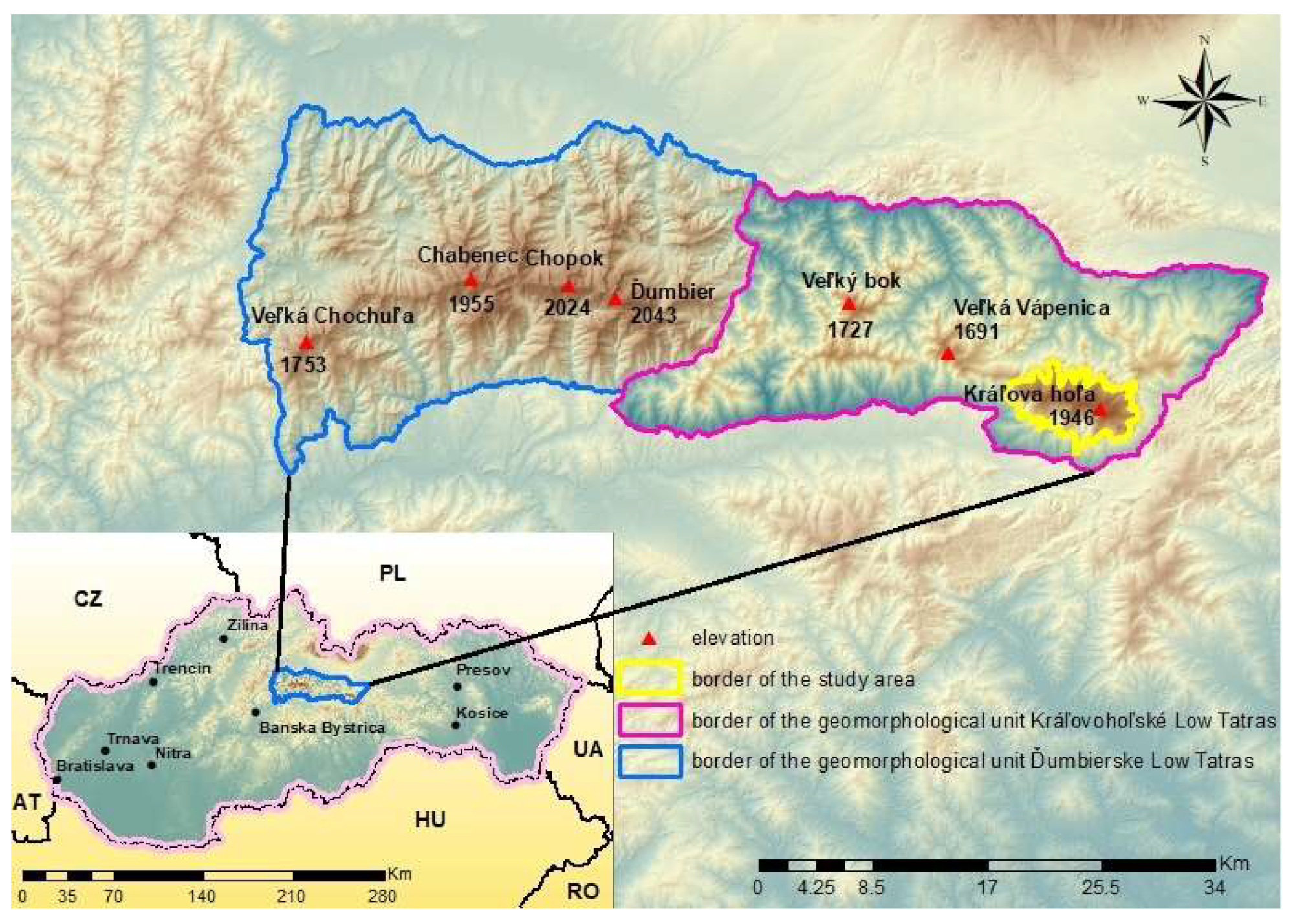
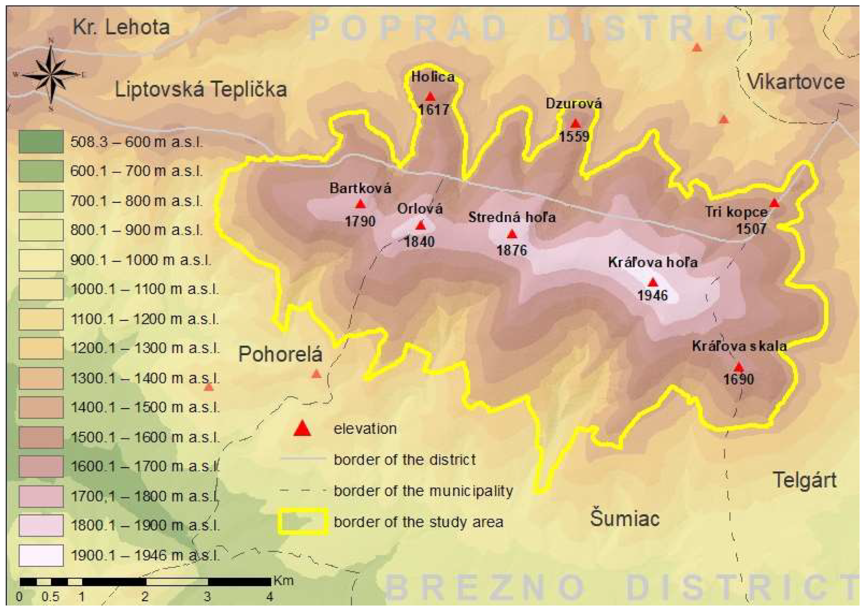
2.1. Study Area
2.1.1. Geological and Geomorphological Conditions
2.1.2. Climatic and Vegetation Conditions
2.2. Data Sources and Pre-Processing
2.3. Trigger Zones Modeling
2.4. Simulation of Avalanche Run-Outs and Avalanche Range
2.4.1. Basic Characteristics of the RAMMS Model
2.4.2. Input Data for the RAMMS Model
3. Results
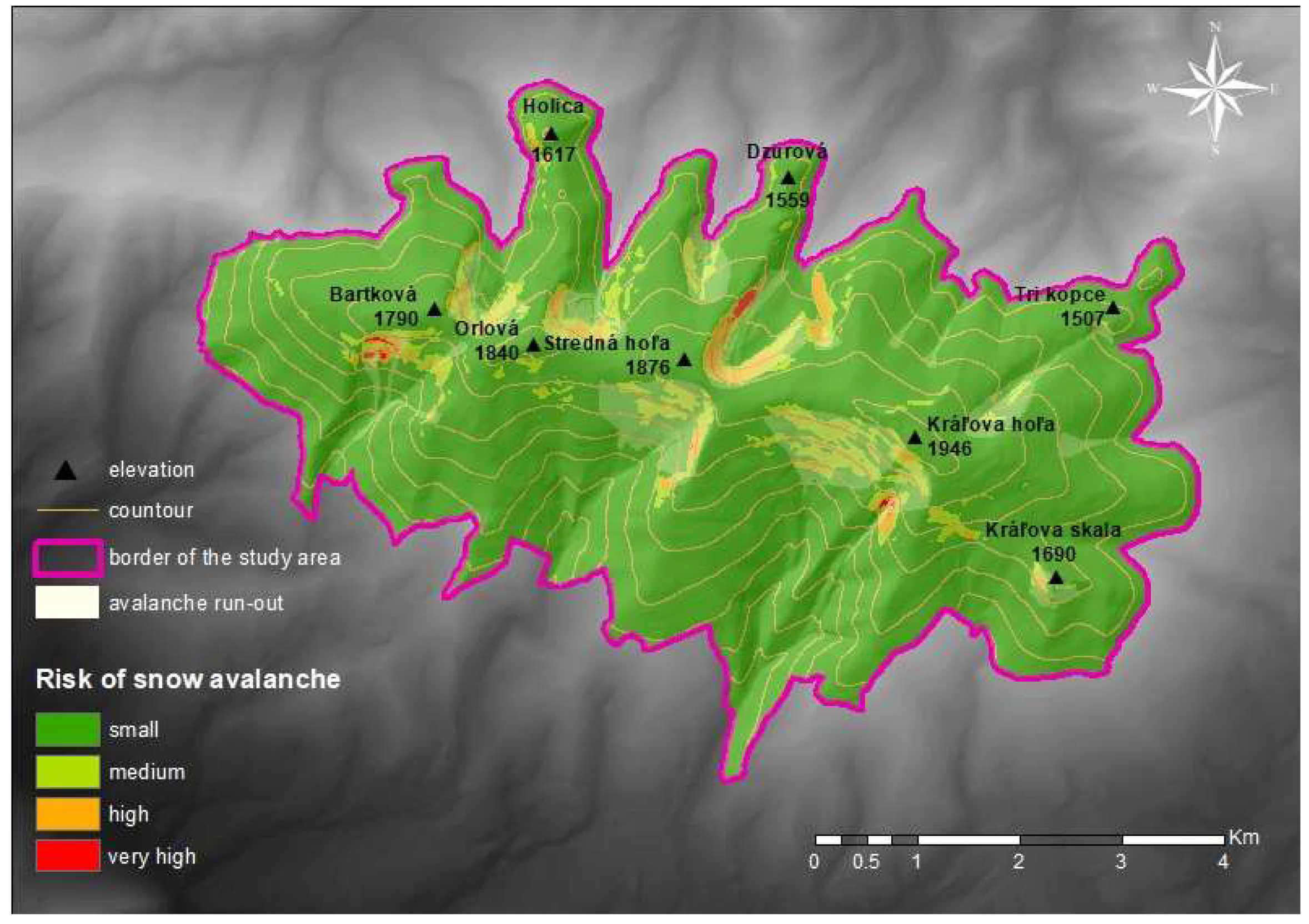
3.1. Results of Triggers Zones Modelling
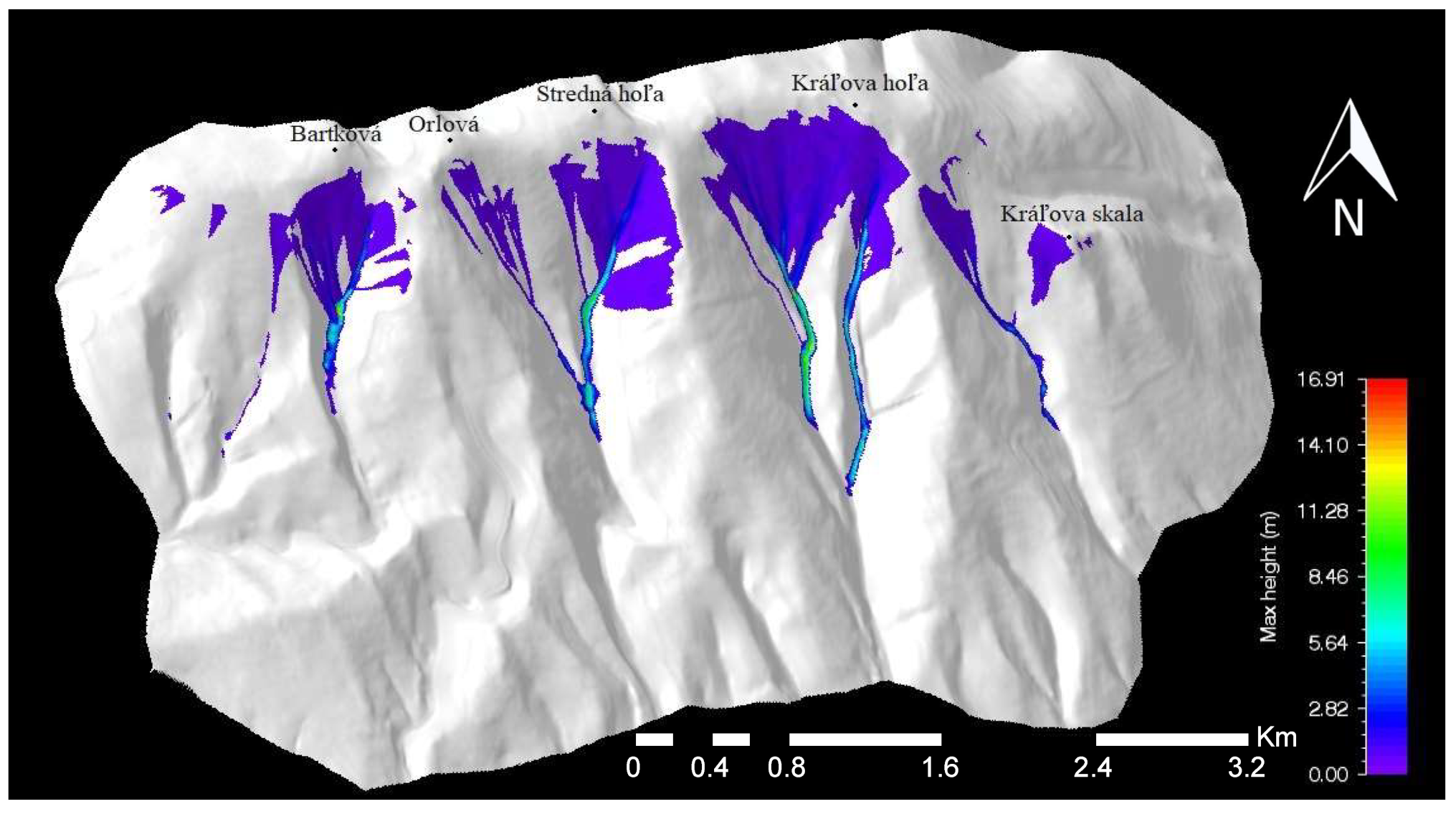
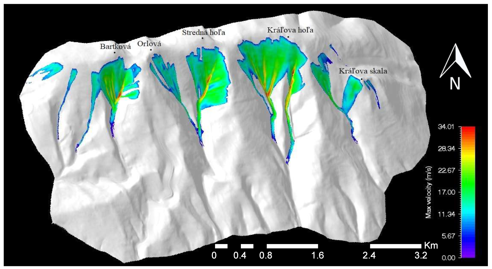
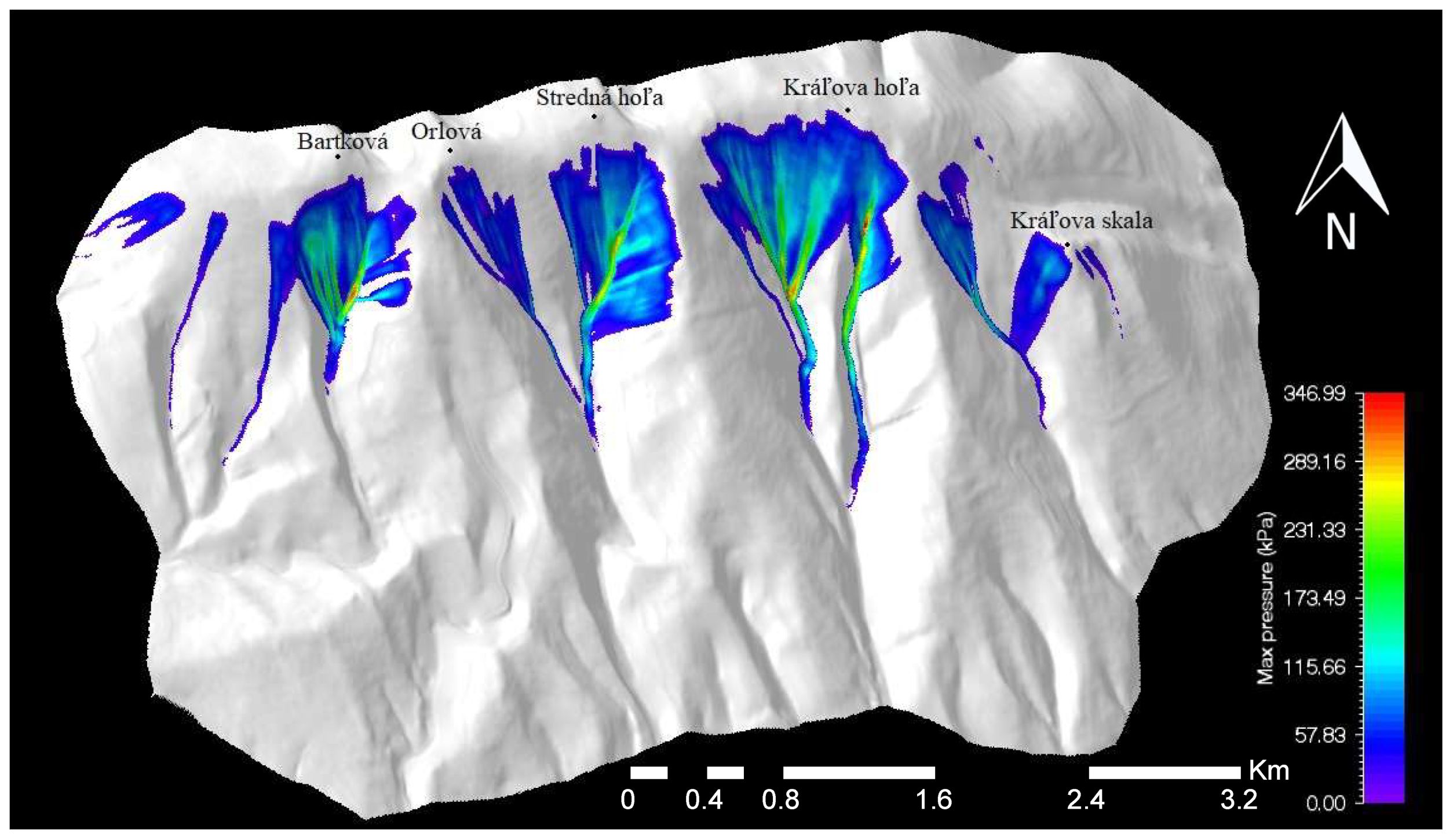
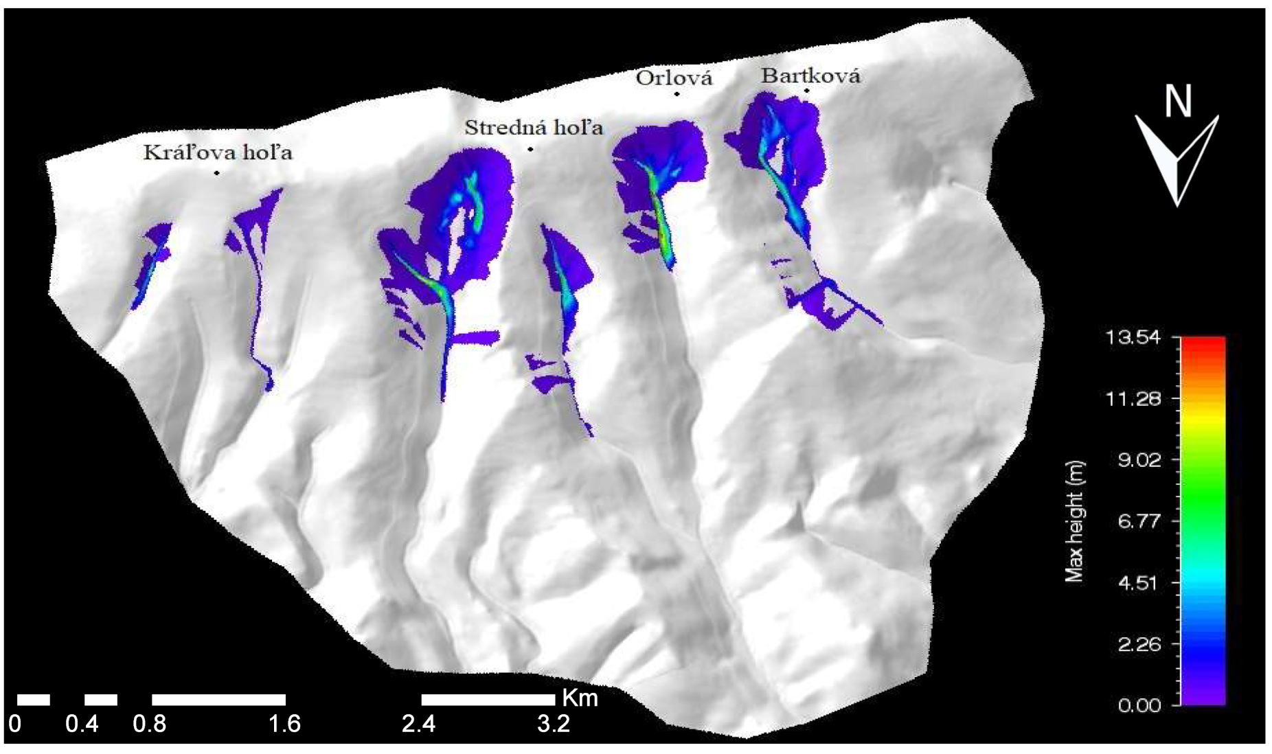
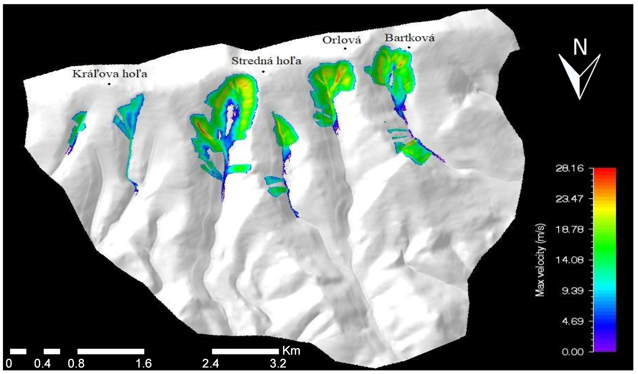
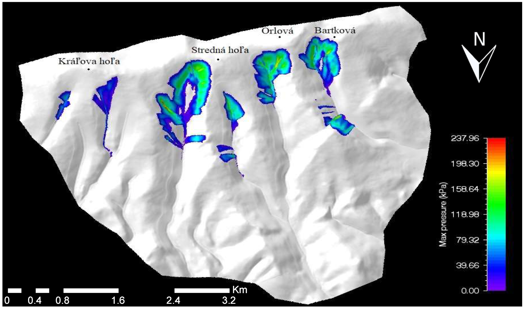
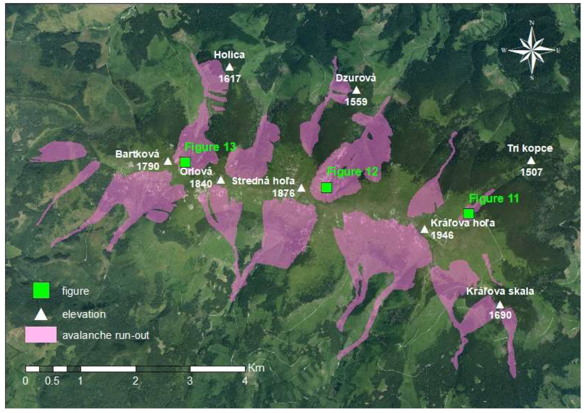
3.2. Results of Avalanche Run-outs and Range Simulations Using the RAMMS Model
4. Discussion
5. Conclusions
Author Contributions
Funding
Institutional Review Board Statement
Informed Consent Statement
Data Availability Statement
Acknowledgments
Conflicts of Interest
References
- Maggioni, M.; Massari, C.H. Extreme Hydroclimatic Events and Multivariate Hazards in a Changing Environment, 1st ed.; Elsevier: Burlington, ON, Canada, 2019; p. 438. [Google Scholar]
- De Quervain, M.R.; De Crécy, L.; Lachapelle, E.R.; Lossev, K.; Shoda, M.; Nakamura, T. Avalanche Atlas: Illustrated International Avalanche Classification; Unesco: Paris, France, 1981; p. 265. [Google Scholar]
- Coaz, J. Die Lauinen der Schweizeralpen; J.Dalp´sche Buch und Kunsthandlung: Bern, Switzerland, 1881. [Google Scholar]
- McClung, D.M.; Schaerer, P. The Avalanche Handbook, 3rd ed.; The Mountaineers Books: Seattle, WA, USA, 2006; p. 288. [Google Scholar]
- Ciolli, M.; Sguerso, D.; Zatelli, P. GIS applications with Grass. Geomat. Workb. 2000, 3, 15–23. [Google Scholar]
- Ciolli, M.; Zatelli, P. Avalanche risk management using GRASS GIS. Geomat. Workb. 2000, 3, 38–49. [Google Scholar]
- Delparte, D.; Jamieson, B.; Waters, N. Statistical runout modeling of snow avalanches using GIS in Glacier National Park, Canada. Cold Reg. Sci. Technol. 2008, 54, 183–192. [Google Scholar] [CrossRef]
- Barbolini, M.; Pagliardi, M.; Ferro, F.; Corradeghini, P. Avalanche hazard mapping over large undocumented areas. Nat. Hazards 2011, 56, 451–464. [Google Scholar] [CrossRef]
- Furdada, G.; Oller, P.; Mases, M.; Vilaplana, J.M. Avalanche mapping and related G.I.S. applications in the Catalan Pyrenees. Surv. Geophys. 1995, 16, 681–693. [Google Scholar] [CrossRef]
- Stoffel, A.; Meister, R.; Schweizer, J. Spatial characteristics of avalanche activity in an Alpine valley—A GIS approach. Ann. Glaciol. 1998, 26, 329–336. [Google Scholar] [CrossRef]
- Ghinoi, A.; Chung, C.H.J. STARTER: A statistical GIS-based model for the prediction of snow avalanche susceptibility using terrain features—Application to Alta Val Badia, Italian Dolomites. Geomorphology 2005, 66, 305–325. [Google Scholar] [CrossRef]
- Asunción, J.A.; Javier, C.H.C. Mapping of avalanche start zones susceptibility: Arazas basin, Ordesa and Monte Perdido National Park (Spanish Pyrenees). J. Maps 2012, 8, 14–21. [Google Scholar] [CrossRef]
- Gruber, U. Using GIS for avalanche hazard mapping in Switzerland. In Proceedings of the Esri International User Conference, San Diego, CA, USA, 8–12 July 2002; pp. 26–35. [Google Scholar]
- Maggioni, M.; Gruber, U.; Stoffel, A. Definition and characterisation of potential avalanche release areas. In Proceedings of the Esri International User Conference, San Diego, CA, USA, 8–12 July 2002; pp. 12–25. [Google Scholar]
- Maggioni, M.; Gruber, U. The influence of topographic parameters on avalanche release dimension and frequency. Cold Reg. Sci. Technol. 2003, 37, 407–419. [Google Scholar] [CrossRef]
- Gruber, U.; Sardemann, S. High-frequency avalanches: Release area characteristics and run-out distances. Cold Reg. Sci. Technol. 2003, 37, 439–451. [Google Scholar] [CrossRef]
- Ancey, C.H.; Gervasoni, C.H.; Meunier, M. Computing extreme avalanches. Cold Reg. Sci. Technol. 2004, 39, 161–180. [Google Scholar] [CrossRef]
- Jamieson, B.; Margreth, S.; Jones, A. Application and limitations of dynamic models for snow avalanche hazard mapping. In Proceedings of the International Snow Science Workshop, Whistler, BC, Canada, 21–27 September 2008; pp. 730–739. [Google Scholar]
- Bovis, M.J.; Mears, A.I. Statistical Prediction of Snow Avalanche Runout from Terrain Variables in Colorado. Arct. Alp. Res. 1976, 8, 115–120. [Google Scholar] [CrossRef]
- Lied, K.; Bakkehøi, S. Empirical calculations of snow-avalanche run-out distance based on topographic parameters. J. Glaciol. 1980, 6, 165–177. [Google Scholar] [CrossRef]
- McClung, D.M.; Mears, A.I. Extreme value prediction of snow avalanche runout. Cold Reg. Sci. Technol. 1991, 19, 163–175. [Google Scholar] [CrossRef]
- Fujisawa, K.; Tsunaki, R.; Kamiishi, I. Estimating snow avalanche runout distances from topographic data. Ann. Glaciol. 1993, 18, 239–244. [Google Scholar] [CrossRef]
- Jones, A.S.T.; Jamieson, B. Statistical avalanche-runout estimation for short slopes in Canada. Ann. Glaciol. 2004, 38, 363–372. [Google Scholar] [CrossRef]
- Delparte, D.M. Avalanche Terrain Modeling in Glacier National Park, Canada. Ph.D. Thesis, University of Calgary, Calgary, AB, Canada, 2008. [Google Scholar]
- Buisson, L.; Charlier, C. Avalanche modelling and integration of expert knowledge in the ELSA system. Ann. Glaciol. 1993, 18, 123–128. [Google Scholar] [CrossRef]
- Sampl, P.; Zwinger, T. Avalanche simulation with SAMOS. Ann. Glaciol. 2004, 38, 393–398. [Google Scholar] [CrossRef]
- Keiler, M.; Sailer, R.; Jörg, P.; Weber, C.; Fuchs, S.; Zischg, A.; Sauermoser, S. Avalanche risk assessment—A multi-temporal approach, results from Galtür, Austria. Nat. Hazards Earth Syst. Sci. 2006, 6, 637–651. [Google Scholar] [CrossRef]
- Cappabianca, F.; Barbolini, M.; Natale, L. Snow avalanche risk assessment and mapping: A new method based on a combination of statistical analysis, avalanche dynamics simulation and empirically-based vulnerability relations integrated in a GIS platform. Cold Reg. Sci. Technol. 2008, 54, 193–205. [Google Scholar] [CrossRef]
- Bühler, Y.; Hüni, A.; Christen, M.; Meister, R.; Kellenberger, T. Automated detection and mapping of avalanche deposits using airborne optical remote sensing data. Cold Reg. Sci. Technol. 2009, 57, 99–106. [Google Scholar] [CrossRef]
- Lato, M.J.; Frauenfelder, R.; Bühler, Y. Automated detection of snow avalanche deposits: Segmentation and classification of optical remote sensing imagery. Nat. Hazards Earth Syst. Sci. 2012, 12, 2893–2906. [Google Scholar] [CrossRef]
- Solberg, R.; Frauenfelder, R.; Larsen, S.Ø.; Salberg, A.B. Experiments with Remote Sensing in the Context of Avalanche Warning and Detection. In Proceedings of the 2012 Advances in Avalanche Forecasting, Podbanské, Slovakia, 22 October 2012; pp. 56–57. [Google Scholar]
- Chrustek, P.; Kolecka, N.; Bühler, Y. Snow avalanches mapping—Evaluation of a new approach. In Proceedings of the 2013 International Snow Science Workshop, Grenoble, France, 7–11 October 2013; pp. 750–755. [Google Scholar]
- Frauenfelder, R.; Solberg, R.; Larsen, S.; Salberg, A.-B.; Bjordal, H. Remote-sensing derived avalanche inventory data. In Proceedings of the 2012 International Snow Science Workshop, Anchorage, AK, USA, 13–21 September 2012; pp. 398–403. [Google Scholar]
- Kňazovický, L. Lavíny; Slovenská Akadémia Vied: Bratislava, Slovakia, 1967; p. 149. [Google Scholar]
- Kňazovický, L. Západné Tatry; Slovenská Akadémia Vied: Bratislava, Slovakia, 1970; p. 210. [Google Scholar]
- Kňazovický, L. Atlas Lavínových Dráh SSR; SÚV ČSZTV: Bratislava, Slovakia, 1978; p. 37. [Google Scholar]
- Kňazovický, L. Nebezpečenstvo Hôr; SÚV ČSZTV: Bratislava, Slovakia, 1984; p. 125. [Google Scholar]
- Lukniš, M. Reliéf Vysokých Tatier a Ich Predpolia; Slovenská Akadémia Vied: Bratislava, Slovakia, 1973; p. 375. [Google Scholar]
- Midriak, R. Morfogenéza Povrchu Vysokých Pohorí; Veda: Bratislava, Slovakia, 1983; p. 513. [Google Scholar]
- Milan, L. Spracovanie katastru lavínových terénov a ich topografickej charakteristiky v horstvách Slovenska. Geogr. Časopis 1981, 33, 145–163. [Google Scholar]
- Milan, L. Lavínové terény a lavínový kataster Vysokých Tatier. Zborník Prác O TANAP 1984, 25, 123–162. [Google Scholar]
- Milan, L. Nebezpečenstvo Lavín; Šport: Bratislava, Slovakia, 1988; p. 151. [Google Scholar]
- Hreško, J. Avalanche hazard of the high mountain landscape in Tatras territory. Folia Geogr. 1998, 30, 348–352. [Google Scholar]
- Hreško, J.; Bugár, G. Avalanche hazard in the southeast part of the Belianske Tatry Mts. Ekológia 2000, 19, 258–263. [Google Scholar]
- Hreško, J.; Bugár, G. Problems of natural hazard assesment and monitoring in the Tatra Mts. Ekológia 2001, 20, 96–100. [Google Scholar]
- Rybár, R. The model application of the avalanche danger in Western Tatras. Ekológia 2002, 21, 431–441. [Google Scholar]
- Barka, I. Identification of snow avalanche trigger areas and avalanche paths by the GIS. Geomorphol. Slovaca Bohem. 2003, 3, 60–63. [Google Scholar]
- Barka, I. Niektoré Metodické Postupy pri Mapovaní Vybraných Geomorfologických Procesov; Univerzita Komenského v Bratislave: Bratislava, Slovakia, 2005; p. 103. [Google Scholar]
- Barka, I.; Rybár, R. Identification of snow avalanche trigger areas using GIS. Ekológia 2003, 2, 182–194. [Google Scholar]
- Žiak, M. Základný koncept navrhovaného lavínového geografického informačného systému. Geomorphol. Slovaca Bohem. 2009, 9, 61–68. [Google Scholar]
- Biskupič, M.; Barka, I. Spatial modelling of snow avalanche run-outs using GIS. In Proceedings of the Zborník z 22. Sjezdu České geografické Společnosti, Ostrava, Czech Republic, 1–3 October 2010; pp. 8–19. [Google Scholar]
- Richnavský, J.; Biskupič, M.; Šír, B.; Bobáľ, P.; Unucka, J.; Ďuricha, M. Avalanche and debris flow modelling in the chosen location of the Moravskoslezske Beskydy Mountains. In Proceedings of the Zborník z 22. Sjezdu České Geografické Společnosti, Ostrava, Czech Republic, 1–3 October 2010; pp. 1–7. [Google Scholar]
- Žiak, M. Lavínová Hrozba, Bilancia Energie a Hmoty vo Vysokohorskom Prostredí. Ph.D. Thesis, Univerzita Komenského v Bratislave, Bratislava, Slovakia, 2012. [Google Scholar]
- Nedelka, D.; Koreň, M. Modelovanie Rizika Vzniku Lavín; Technická Univerzita vo Zvolene: Zvolen, Slovakia, 2014; p. 9. [Google Scholar]
- Boltižiar, M.; Biskupič, M.; Barka, I. Spatial modelling of avalanches by application of GIS on selected slopes of the Western Tatra Mts. and Belianske Tatra Mts. Geogr. Pol. 2016, 89, 79–90. [Google Scholar] [CrossRef]
- Žiak, M. Lavínová hrozba vo vysokohorskom prostredí Slovenska a Poľska. Geomorphol. Slovaca Bohem. 2017, 17, 1–99. [Google Scholar]
- Biskupič, M. Avalanche Monitoring and Run-Out Modeling Using GIS. Ph.D. Thesis, Univerzita Karlova v Prahe, Praha, Czech Republic, 2017. [Google Scholar]
- Biely, A.; Beňuška, P.; Bezák, V.; Bujnovský, A.; Halouzka, R.; Ivanička, J.; Kohút, M.; Klinec, A.; Lukáčik, E.; Maglay, J.; et al. Geologická Mapa Nízkych Tatier; Vydavatelstvo Dionýza Štúra: Bratislava, Slovakia, 1992; p. 131. [Google Scholar]
- Roth, S. Spuren einstiger Gletscher in der Niederen Tatry. Földtani Közlöny 1885, 15, 558–560. [Google Scholar]
- Partsch, J. Die Eiszeit in der Niederen Tatra. Globus 1904, 85, 657–665. [Google Scholar]
- Sawicki, L. Die Eiszeit spuren in der Niederen Tatra. Globus 1910, 91, 324–329. [Google Scholar]
- Vitásek, F. Pleistocenní zalednění severní strany Nízkých Tater. In Proceedings of the Comptes Rendus du ler Congrés des Géographes et Ethnographes Slaves, Praha, Czech Republic, 1–4 October 1924; pp. 5–7. [Google Scholar]
- Kettner, R. Neznáme stopy bývalého zalednění pod Velkým Bokem v Nízkých Tatrách. Věda Přírodní 1933, 14, 1–129. [Google Scholar]
- Louček, D. Geomorfologie velehorské oblasti Královy Holy v Nízkých Tatrách. Rozpr. Československé Akad. Věd 1954, 64, 1–19. [Google Scholar]
- Louček, D.; Michovská, E.; Trefná, E. Zalednění Nízkých Tater. Sborník Československé Společnosti Zeměpisné 1960, 65, 326–352. [Google Scholar]
- Lukniš, M. Priebeh posledného zaľadnenia Západných Karpát vo vzťahu k Alpám a zaľadneniu severnej Európy. Geogr. Časopis 1964, 16, 289–299. [Google Scholar]
- Škvarček, A. Niektoré aspekty pleistocénneho zaľadnenia Kráľovohoľských Tatier. Geogr. Časopis 1986, 38, 236–244. [Google Scholar]
- Škvarček, A. Zaľadnenie a prejavy iných morfogenetických procesov posledného glaciálu v reliéfe Kráľovohoľských Tatier. AFRN Geogr. 1990, 34, 25–43. [Google Scholar]
- Gajdoš, A.; Klaučo, M. Doterajší stav výskumu glaciálnych foriem georeliéfu v Nízkych Tatrách. Geogr. Rev. 2010, 6, 24–41. [Google Scholar]
- Gajdoš, A.; Anstead, L. The problems concerning occurence of glacial landforms on southern slope of Low Tatra mountains in Slovakia. Fyz. Sborník 2013, 11, 40–44. [Google Scholar]
- Lapin, M.; Faško, P.; Melo, P.; Šťastný, M.; Tomlain, J. Atlas Krajiny Slovenskej Republiky; Ministerstvo Životného Prostredia Slovenskej Republiky: Bratislava, Slovakia, 2002; p. 344. [Google Scholar]
- Bochníček, O.; Hrušková, K.; Zvara, M. Klimatický Atlas Slovenska; Slovenský Hydrometeorologický Ústav: Bratislava, Slovakia, 2015; p. 131. [Google Scholar]
- Biskupič, M. Modelovanie Dosahu lavín s Použitím GIS. Master’s Thesis, Univerzita Karlova v Prahe, Praha, Czech Republic, 2008. [Google Scholar]
- Christen, M.; Bartelt, P.; Bühler, Y.; Deubelbeiss, Y.; Salz, M.; Schneider, M.; Schumacher, L. RAMMS User Manual v1.7.0.: A Modeling System for Snow-Avalanches in Research and Practice; WSL Intitute for Snow and Avalanche Research: Birmensdorf, Switzerland, 2017; p. 104. [Google Scholar]
- Hreško, J.; Bugár, G.; Boltižiar, M.; Kohút, F. The dynamics of recent geomorphic processes in the alpine zone of the Tatra Mts. Geogr. Pol. 2008, 81, 53–65. [Google Scholar]
- Šilhán, K.; Tichavský, R. Snow avalanche and debris flow activity in the High Tatras Mountains: New data from using dendrogeomorphic survey. Cold Reg. Sci. Technol. 2017, 52, 45–53. [Google Scholar] [CrossRef]
- Žiak, M. Analýza Podmienok Vzniku Lavín a jej Aplikácia pri Lavínovej Predpovedi (na Príklade Vybraného územia Malej Fatry). Master’s Thesis, Univerzita Komenského v Bratislave, Bratislava, Slovakia, 2007. [Google Scholar]
- Szalmová, L.; Minár, J.; Žiak, M. Regionálna typizácia a výber reprezentatívnych lavínových dráh v Malej Fatre. Acta Geogr. 2013, 57, 17–30. [Google Scholar]
- Holec, J.; Bednarik, M.; Liščák, P.; Žilka, A.; Vitovič, L. Assessment of debris flow susceptibility using bivariate and multivariate statistical analyses and verification based on catastrophic events from 2014 in the Krivánska Fatra Mountains, Slovakia. Acta Geol. Slovaca 2018, 10, 1–19. [Google Scholar]
- Máliková, V. Morfometrická analýza a morfodynamické procesy vo vybranej časti Malej Fatry. Geogr. Inf. 2018, 22, 148–162. [Google Scholar] [CrossRef]
- Midriak, R. Štúdia o účinnosti Pôdoochranných a Protilavínových Opatrení v Oblasti Krížnej; Výskumný ústav Lesného Hospodárstva: Zvolen, Slovakia, 1971; p. 91. [Google Scholar]
- Jendrišáková, S.; Kováčiková, Z.; Vargová, V.; Michalec, M. The impact of cattle and sheep grazing on grassland in Veľká Fatra National Park. J. Water Land Dev. 2011, 23, 83–90. [Google Scholar] [CrossRef]
- Babčan, M.; Hríbik, M.; Bartík, M.; Škvarenina, J. The avalanche landscape impacts modelling by using the ELBA + model RAMMS in Krížna-massif. Zborník 2014, 2, 67–76. [Google Scholar]
- Lepeška, T. Dynamics of development and variability of surface degradation in the subalpine and alpine zones (an example from the Velká Fatra Mts., Slovakia). Open Geosci. 2016, 8, 771–786. [Google Scholar] [CrossRef]
- Stankoviansky, M. Súčasné exogénne reliéfotvorné procesy Ďumbierskych Tatier. Sborník Československé Geogr. Společnosti 1984, 89, 285–296. [Google Scholar]
- Seres, A. The Effects of Terrain, Snowpack and Weather Parameters on Generation of Avalanches, Low Tatras, Slovakia. Master’s Thesis, University of Miskolc, Miskolc, Hungary, 2002. [Google Scholar]
- Bartík, M.; Hríbik, M.; Škvarenina, J. Avalanche simulation in surrounding of settlement Magurka with ELBA+ model. Zprávy Lesn. Výzkumu 2013, 58, 287–293. [Google Scholar]
- Seres, A. AvalMap—A snowpack, weather, terrain and land cover based avalanche hazard model for the Low Tatras, Slovakia. In Proceedings of the International Snow Science Workshop, Innsbruck, Austria, 7–12 October 2018; pp. 12–18. [Google Scholar]
- Kohút, F. Natural Processes High Mountain Landscape—Jalovecká Valley. Ph.D. Thesis, Univerzita Konštantína Filozofa v Nitre, Nitra, Slovakia, 2005. [Google Scholar]
- Deems, J.S.; Gadomski, P.J.; Vellone, D.; Evanczyk, R.; LeWinter, A.L.; Birkeland, K.W.; Finnegan, D.C. Mapping starting zone snow depth with a ground-based lidar to assist avalanche control and forecasting. Cold Reg. Sci. Technol. 2015, 120, 197–204. [Google Scholar] [CrossRef]
- Keyani, B.S.; Guo, S. Avalanche Hazard Maps Production Using ARCGIS; Polytechnic University of Milan: Milan, Italy, 2017; p. 30. [Google Scholar]
- McClung, D.M. Characteristics of terrain, snow supply and forest cover for avalanche initiation caused by logging. Ann. Glaciol. 2017, 32, 223–229. [Google Scholar] [CrossRef]
- Oller, P.; Janeras, M.; de Buen, H.; Arnó, G.; Christen, M.; García, C.; Martínez, P. Using AVAL-1D to simulate avalanches in the eastern Pyrenees. Cold Reg. Sci. Technol. 2010, 64, 190–198. [Google Scholar] [CrossRef][Green Version]
- Fazzini, M.; Cordeschi, M.; Carabella, C.; Paglia, G.; Esposito, G.; Miccadei, E. Snow Avalanche Assessment in Mass Movement-Prone Areas: Results from Climate Extremization in Relationship with Environmental Risk Reduction in the Prati di Tivo Area (Gran Sasso Massif, Central Italy). Land 2021, 10, 1176. [Google Scholar] [CrossRef]
- Statham, G.; Haegeli, P.; Greene, E.; Birkeland, K.; Israelson, C.; Tremper, B.; Stethem, C.; McMahon, B.; White, B.; Kelly, J. A conceptual model of avalanche hazard. Nat. Hazards 2018, 90, 663–691. [Google Scholar] [CrossRef]
- Bartelt, P.; Salm, B.; Gruber, U. Calculating dense snow avalanche runout using a Voellmy-fluid model with active/passive longitudinal straining. J. Glaciol. 1999, 45, 242–254. [Google Scholar] [CrossRef]
- Casteller, A.; Christen, M.; Villalba, R.; Martínez, H.; Stöckli, V.; Leiva, J.C.; Bartelt, P. Validating numerical simulations of snow avalancher using dendrochronology: The Cerro Ventana event in Northern Patagonia, Argentina. Nat. Hazards Earth Syst. Sci. 2008, 8, 433–443. [Google Scholar] [CrossRef]
- Christen, M.; Kowalski, J.; Bartelt, P. RAMMS: Numerical simulation of dense snow avalanches in three-dimensional terrain. Cold Reg. Sci. Technol. 2011, 65, 1–14. [Google Scholar] [CrossRef]
- Maggioni, M.; Freppaz, M.; Christen, M.; Bartelt, P.; Zanini, E. Back-calculation of small avalanches with the 2D avalanche dynamics model RAMMS: Four events artificially triggered at the seehore test site in Aosta valley (NW Italy). In Proceedings of the International Snow Science Workshop, Anchorage, AK, USA, 13–21 September 2012; pp. 591–598. [Google Scholar]
- Mahboob, M.A.; Iqbal, J.; Atif, I. Modeling and simulation of glacier avalanche: A case study of Gayari sector glacier hazard assessment. IEEE Trans. Geosci. Remote Sens. 2015, 53, 5824–5834. [Google Scholar] [CrossRef]
- Christen, M.; Bartelt, P.; Kowalski, J. Back calculation of the in den Arelen avalanche with RAMMS: Interpretation of model results. Ann. Glaciol. 2017, 51, 161–168. [Google Scholar] [CrossRef]
- Harvey, S.; Schmudlach, G.; Bühler, Y.; Dürr, L.; Stoffel, A.; Christen, M. Avalanche terrain maps for backcountry skiing in Switzerland. In Proceedings of the International Snow Science Workshop, Innsbruck, Austria, 7–12 October 2018; pp. 1625–1631. [Google Scholar]
- Gilany, N.; Iqbal, J. Simulation of glacial avalanche hazards in Shyok basin of upper Indus. Sci. Rep. 2019, 9, 20077. [Google Scholar] [CrossRef] [PubMed]


| Altitude (m a.s.l.) | Altitude Factor (Al) | Profile Curvature (in m−1) | Profile Curvature Factor (Fy) | Plan Curvature (in m−1) | Plan Curvature Factor (Fx) |
|---|---|---|---|---|---|
| below 1300 | 0 | (−4)–(−0.2) | 1 | 4–0.2 | 1 |
| 1300–1500 | 1 | (−0.2)–0.2 | 1 | 0.2–(−0.2) | 1 |
| over 1500 | 2 | 0.2–0.5 | 1 | (−0.2)–(−0.5) | 1 |
| 0.5–4 | 0.5 | (−0.5)–(−4) | 0.5 | ||
| Exposure | Exposure factor (Ex) | Slope (in degrees) | Slope factor (S) | Type of land cover | Roughness factor (Rg) |
| NW | 0.4 | (0–10)°, (70–90)° | 0 | forest (coniferous, broadleaf, mixed) | 0.5 |
| NE | 0.5 | (10–19)°, (60–70)° | 0.4 | incoherent forest with mountain pine, thick boulder debris and slopes with smaller blocks | 1.2 |
| E | 0.7 | (19–25)°, (55–60)° | 0.8 | shrub cover | 1.4 |
| N | 0.8 | (25–30)°, (50–55)° | 1.2 | sparse forest (grass and trees) | 1.5 |
| SW | 1 | (30–35)°, (45–50)° | 1.6 | continuous mountain pine, slopes with bedrock protrusions up to 50 cm | 2.5 |
| SE | 1.5 | (35–45)° | 2 | grass with incoherent mountain pine, small fragmentary debris slopes | 2.8 |
| W | 1.7 | grassland, rock seas, rock plates | 3 | ||
| S | 2 |
| The Result of Equation Av | Danger of an Avalanche Trigger |
|---|---|
| 0–15 | small |
| 15–22.5 | medium |
| 22.5–30 | high |
| 30–36 | very high |
| Risk of Snow Avalanche | Percentage of the Studied Area * | Expanse of Territory |
|---|---|---|
| small | 92.44% | 32 km2 |
| medium | 5.87% | 2 km2 |
| high | 1.53% | 0.5 km2 |
| very high | 0.16% | 0.1 km2 |
Publisher’s Note: MDPI stays neutral with regard to jurisdictional claims in published maps and institutional affiliations. |
© 2022 by the authors. Licensee MDPI, Basel, Switzerland. This article is an open access article distributed under the terms and conditions of the Creative Commons Attribution (CC BY) license (https://creativecommons.org/licenses/by/4.0/).
Share and Cite
Košová, V.; Molokáč, M.; Čech, V.; Jesenský, M. Avalanche Hazard Modelling within the Kráľova Hoľa Area in the Low Tatra Mountains in Slovakia. Land 2022, 11, 766. https://doi.org/10.3390/land11060766
Košová V, Molokáč M, Čech V, Jesenský M. Avalanche Hazard Modelling within the Kráľova Hoľa Area in the Low Tatra Mountains in Slovakia. Land. 2022; 11(6):766. https://doi.org/10.3390/land11060766
Chicago/Turabian StyleKošová, Vladislava, Mário Molokáč, Vladimír Čech, and Miloš Jesenský. 2022. "Avalanche Hazard Modelling within the Kráľova Hoľa Area in the Low Tatra Mountains in Slovakia" Land 11, no. 6: 766. https://doi.org/10.3390/land11060766
APA StyleKošová, V., Molokáč, M., Čech, V., & Jesenský, M. (2022). Avalanche Hazard Modelling within the Kráľova Hoľa Area in the Low Tatra Mountains in Slovakia. Land, 11(6), 766. https://doi.org/10.3390/land11060766