Abstract
The GIAHS-FAO program enhances the agricultural systems coevolved with humans through their dynamic conservation to guarantee the livelihood of future generations. The aim of this research was to assess, with a dynamic perspective, the terraced landscape’s integrity in a potential GIAHS-FAO site (Northwest Piedmont, Italy, 545 ha) characterized by a pergola caremiese vine-breeding technique. We developed a GIS-based approach to explore the main features that can affect the landscape’s integrity, starting from the changes of the land use. The aerial IGMI images (1954–1968) and the AGEA (2018) orthophoto were photo-interpreted using QGIS 3.16.2 “Hannover” (minimum mappable unit 100 m2). The results showed that 70.16% of the historical landscape was preserved, while the surface of vineyards decreased because of their abandonment. We observed that vineyards are the land use that requires more attention in future planning strategies, and that the landscape’s integrity is affected by the limited introduction of non-traditional vine-breeding techniques (espaliers) and new crops (olives groves). The methodology was able to assess the terraced landscape’s integrity in a dynamic perspective. The good integrity makes the study area a potential GIAHS-FAO site. Future planning strategies will have to lead the changing processes and preserve the landscape’s integrity.
1. Introduction
In Europe, many rural landscapes are characterized by high historical value as the result of the interaction between humans and nature in past conditions [1]. Agnoletti et al. [2] highlighted that these landscapes have an important role in preserving bio-cultural heritage. Indeed, the historical landscapes preserve traditional agricultural practices, which are the expression of ancient knowledge. However, they are affected by the introduction of more modern and mechanizable practices that change the landscape [3]. Patel et al. [4] reported that the traditional practices are more sustainable than modern ones and ensure a higher resilience of the agricultural system to climate change. In Italy during the COVID-19 pandemic, a lower incidence of COVID-19 cases in rural areas characterized by the presence of traditional agriculture was observed compared with plain areas characterized by intensive systems [5]. Furthermore, historical rural landscapes safeguard ancient cultivars that constitute an important reserve of biodiversity and represent a genetic heritage that should be preserved [6]. Bhaskar et al. highlighted that traditional agricultural landscapes in Western India are mosaics of natural features and agricultural land uses [7]. In slope conditions, many rural landscapes were made arable by humans through land terracing using dry-stone walls [8]. Terraced landscapes are anthropic landscapes characterized by multiple values, such as, for example, the reduction of the slopes’ erosion, the provision of ecosystem services, and the storage of soil carbon [9]. However, they are nowadays threatened by the abandonment of traditional cultivations with the consequent uncontrolled re-vegetation of the terraces that causes the dry-stone walls to collapse and the hydrogeological risk to increase [10]. Gullino et al. [11] showed that different Italian terraced landscapes considered as world heritage sites are affected by the deterioration of dry-stone walls and land fragmentation, with many problems of hydrogeological instability. For these reasons, many authors recommended the development of future planning strategies and policies for the conservation and enhancement of terraced landscapes [12,13,14].
At the national and international levels, some projects are aimed at enhancing historical rural landscapes through the recognition of their quality. The Italian Ministry of Agricultural, Food and Forestry Policies instituted, exactly ten years ago, the National Observatory of the Historical Rural Landscapes and the National Register of the Historical Rural Landscapes, Agricultural Practices, and Traditional Knowledges [15]. The necessity of their institution followed over half a century of agricultural intensification and the necessity to have an inventory of the Italian historical rural landscapes in order to facilitate their enhancement, to highlight their cultural values, and to increase the awareness of citizens [16]. To be admitted into the register, the proponents of a landscape must pass two steps: the presentation of a synthetic form with the main characteristics of the landscape proposed and—if positively evaluated by the National Observatory—the presentation of the extended application dossier. The importance of this recognition and the presence of numerous heterogeneous historical rural landscapes in Italy are demonstrated by the high number of sites that started the procedure (more than 120 demands in ten years). Nowadays, 27 have been inscribed in the register, though none of them are located in the Piedmont region [17]. Three parameters have to be assessed to propose a site for inscription to the register: the significance, the integrity, and the vulnerability [18]. The parameters of significance and vulnerability require qualitative analyses comprised of archival analyses, field inspections, and the involvement of rural communities with bottom–up approaches. The evaluation of the parameter of the integrity needs a series of quantitative analyses through cartographic elaborations. To be admitted, at least the 50% of the historical rural landscape in the proposed area has to be preserved.
At the international level, the Globally Important Agricultural Heritage Systems (GIAHS) program of the Food and Agriculture Organization of the United Nations (FAO), since 2002, collects the agricultural heritage systems of the world in order to promote and to enhance them [19]. It is an important instrument for territorial development based on traditional agriculture [20]. Bixia et al. [21] highlighted its strategic role in attracting rural tourism, which contributes to territorial enhancement. To be admitted, a site has to satisfy five inscription criteria and present an action plan for the sustainability of the system. These criteria are as follows: 1. food and livelihood security, 2. agro-biodiversity, 3. local and traditional knowledge systems, 4. cultures, value systems, and social organizations, and 5. landscape and seascape features [22]. The FAO approach recognizes the landscape as not a static museum but as a dynamic agroforestry system, and the result of coevolution with humans [23]. Indeed, dynamic conservation is the strategic key point of the GIAHS program [24]. Concerning the fifth criterion, Jiao et al. [25] highlighted that the land use can be assumed as indicator for the ecological conservation of the agricultural landscapes. Fuller et al. [26] showed that the landscape of a GIAHS site is the result of the interaction between human and physical systems and that the study of the land-use changes is a challenge since they can have an impact on the entire system. The guidelines for a GIAHS proposal report the importance of the historic background and of the contemporary relevance of the sites without establishing a threshold of integrity as the National Register does. However, they recommend assessing the integrity of the structure of the landscape through the creation of past and present land-use maps [27]. In Europe seven sites are inscribed to the GIAHS program, two of which are terraced landscapes of Italy already enrolled in the National Register [28]. Indeed, in Italy the GIAHS program and the National Register of the Historical Rural Landscapes are strictly connected since the sites proposed for the former are mainly selected among the sites inscribed in the second.
Figure 1 synthetizes the parameters and criteria to be assessed for the enrollment to the National Register of the Historical Rural Landscapes and to the GIAHS Program. It shows also the distribution of the already inscribed sites in Italy.
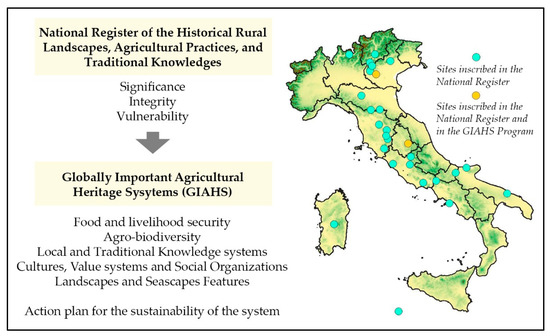
Figure 1.
The parameters and criteria to be assessed for the enrollment to the National Register of the Historical Rural Landscapes and to the GIAHS Program, and the distribution of the already inscribed sites in Italy.
An important recognition of the landscape quality based on the parameter of the integrity is represented by the World Heritage List of the United Nations Organization for Education, Science, and Culture (UNESCO). In Italy different sites inscribed in this list are characterized by the presence of traditional agriculture supported by terraces [29]. Gullino et al. [30] highlighted that, since the integrity is the combination between the level of cultural value continuity and the level of natural value conservation, the historical analyses aimed at its definition have to consider the study of the land use. For doing that, the use of aerial images and orthophotos and their photointerpretation are recognized in the literature [31].
While the parameter of the integrity in UNESCO sites was explored by many authors [32], we observed a lack of studies about the assessment of the integrity of GIAHS-FAO sites. Indeed, the concept of the integrity is assumed by UNESCO as the critical parameter to be maintained for the conservation of a world heritage site with a static approach [33]. Instead, as we discussed above, the purpose of the FAO program is the dynamic conservation of a GIAHS site. The attribute “dynamic” changes completely the approach for the conservation of the historical rural landscapes. Indeed, according to Wenjun et al. [34], a GIAHS-FAO site is a living agricultural system that maintains the historical features but it is also in continuum coevolution with the rural communities to which guarantees the continuous livelihood. The authors highlighted the need of the development of dynamic monitoring systems for the GIAHS conservation and management. Since the GIAHS sites are characterized by traditional agricultural practices and historical landscape’s features, the assessment of the parameter of the integrity in a dynamic perspective is a challenge. In this context, the aim of the research was to assess with a dynamic perspective the terraced landscape’s integrity in a potential GIAHS-FAO site characterized by the presence of terraced vineyards, located in Northwest Piedmont (Italy). We developed a GIS-based approach in order to explore the main features that can affect the landscape’s integrity starting from the changes of the land use occurred between the middle of the last century to nowadays. The methodology is internationally replicable in other sites characterized by terraced landscapes with high historical values, dynamically coevolved with the rural communities. In these contexts, the assessment of the landscapes’ integrity is the first step to develop future planning strategies for their not static but dynamic conservation.
2. Materials and Methods
2.1. Study Area
Vine terraced landscape located in Northwest Piedmont (Italy) was selected for the methodology application (Figure 2a). It is currently in course of application to the National Register of the Historical Rural Landscapes. The first step was successfully passed, and the application dossier is nowadays in course of evaluation by the National Observatory. Pomatto et al. [35] showed that it is characterized by landscape’s historical elements of world uniqueness and traditional agricultural practices. They highlighted the necessity of more studies about its landscape’s dynamics in quantitative terms and change monitoring. Four municipalities are included in the study area: Borgofranco di Ivrea, Carema, Nomaglio and Settimo Vittone (Metropolitan City of Turin). One of them was included among the organizations actively involved in the safeguard of the “art of dry stone walling, knowledge, and techniques”, which is included in the UNESCO’s Representative List of Intangible Cultural Heritage of Humanity [36].
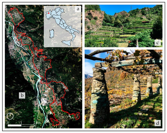
Figure 2.
(a) The localization of the study area in the context of the Italian regions. (b) The boundaries of the study area. (c) The vine terraced landscape with the traditional vine-breeding technique that characterizes the study area. (d) Detail of the stone columns that support the pergola caremiese which is an important landmark of the unique historical landscape of the study area.
The study area (545 ha) was defined according to the parameters established by the National Observatory for the admission in the National Register: unitary and homogeneous area in which the historical landscape covers at least the 50% of the total surface, without modern urbanized areas historically not connected with the agricultural system (Figure 2b). The traditional vine-breeding technique is the pergola caremiese which is a high pergola made with chestnut poles and supported by stone columns (Figure 2c,d). These columns are a fundamental landmark of the landscape that bring it unique in the world. To them an important role in reducing the temperature range between day and night is recognized. For this reason they are also known as “stove columns”. The main vine variety cultivated is the Nebbiolo. The quality of the wine produced is demonstrated by two Denomination of Controlled Origin, one of them is also a Slow Food Presidium.
2.2. Methodological Framework for the Assessment of the Integrity
Since the study of the land-use changes is the first step for the assessment of the integrity of a historical landscape in quantitative terms, we focused on the cartographical studies in the Geographic Information System using QGIS software, version 3.16.2, code name: “Hannover” (open access software of the Open Source Geospatial Foundation-OSGeo). The historical and cultural evaluation approach was assumed [37]. It considers the elaboration of past and present land-use maps in order to study the changes of the historical landscape and evaluate the strategies for its planning, management and conservation. Jaworek-Jakubska et al. [38] proposed a spatial-temporal analysis in order to assess the dynamics of the Polish traditional landscape, using aerial images and cartographical elaborations. Furthermore, the use of the photointerpretation for the assessment of the landscape’s dynamics and for the change monitoring is widely recognized by the scientific community [39,40,41,42].
In this context, in order to assess the integrity of the vineyard terraced landscape with a dynamic perspective, we acquired the historical aerial images and the most recent orthophotograph available covering the study area. We obtained through photointerpretation the historical land-use (HLU) map, the current land-use (CLU) map, and the maps of the stone elements characterizing the landscape. We assessed the dynamics of the landscape and we applied some landscape indicators. Finally, we identified the land use that requires more attention in future planning strategies in order to maintain the landscape’s integrity. Figure 3 shows the methodological framework for the assessment of the integrity with a dynamic perspective applied in the research.
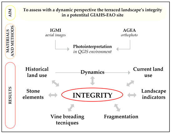
Figure 3.
The methodological framework for the assessment of the integrity with a dynamic perspective applied in the research.
2.3. The Selection of the Sources and the Process of Photointerpretation
Regarding the historical land-use map, we assumed the middle of the last century as reference period to define as historic the land use. Indeed, in literature is well established that the abandonment of terraced landscapes and the process of dry-stone walls damage started at the end of the 1800s and accelerated after the 1950s [43]. For this reason, also the National Register of the Historical Rural Landscapes’ approach requires the evaluation of the dynamics occurred from the middle of the last century to nowadays. The Italian law recognizes as historical a vineyard dating back to before the 1960 and cultivated with the traditional practices [44].
In Italy the only available aerial images of that period were acquired by the Italian Military Geographical Institute (IGMI) [45]. Unfortunately, only one aerial image covering all of the study area was available. It was referred to 1954 but with a very low resolution (acquired at quote 10,000 m and scale 1:50,000) and unusable for the photointerpretation. An aerial image referred to 1954 characterized by higher resolution (acquired at quote 5000 m and scale 1:29,000) was present only for the southern part of the study area. For the northern was available the IGMI’s aerial image referred to 1968 (acquired at quote 4900 m and scale 1:25,000). Instead, a small central part of the study area was not covered by any historical aerial image. For these reasons, we used for the elaboration of the historical land-use map the aerial image IGMI 1954 more defined covering the southern part of the study area, and the aerial image IGMI 1968 covering the northern. The elaboration of the HLU map (referred to the 1954 to the southern part of the study area and to the 1968 for the northern) allowed us to obtain the land use of the middle of the last century.
Regarding the current land-use map, we used the most recent orthophoto available. It was the orthophoto of the Italian Agricultural Payments Agency (AGEA) referred to 2018 (medium resolution 30 × 30 cm2). We obtained it through the cartographic geoportal of the Piedmont Region [46]. In this case it was possible to produce the map covering all of the study area. The elaboration of the CLU map (referred to the 2018) allowed us to obtain the land use characterizing nowadays the landscape.
We georeferenced the white/black historical aerial images, while the colored orthophoto of the AGEA was already georeferenced. Figure 4 schematizes the sources used for the elaboration of the historical and current land-use maps in function of the availability of photo-interpretable historical aerial images and current orthophotos. The production of the HLU map and of the CLU map was the first step of the research, all of the following analyses in which there is a comparison from the middle of the last century to nowadays are based on them.
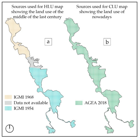
Figure 4.
(a) The aerial images of the Italian Military Geographical Institute (IGMI) referred to the 1968 for the northern part of the study area and referred to the 1954 for the southern used for the elaboration of the historical land-use map showing the land use of the middle of the last century. (b) The orthophoto of the Italian Agricultural Payments Agency (AGEA) referred to the 2018 and covering all the surface of the study area used for the elaboration of the current land-use map showing the land use of nowadays.
According to Rizzo et al. [47], before starting the photointerpretation we proceeded with a general observation of the structure of the different elements of the landscape’s mosaic and their arrangement in the space, and we defined the land use classes to consider. For doing that several studies proposed to use the classification of the Corinne Land Cover [48,49,50,51]. We decided to classify the land use adopting a higher level of detail for the agricultural classes then the others classes (e.g., urbanized areas). Table 1 reports the classes of the land use identified for the photointerpretation and their description.

Table 1.
Classes of the land use identified for the photointerpretation.
During the photointerpretation we decided to adopt a high level of detail, fixing to 100 m2 the minimum mappable unit and to 1:1500 the scale of acquisition of the HLU and CLU maps. We digitalized all the features of the historical and the current land-use maps making sure that there were no contiguous patches characterized by the same land use. We divided the vineyards characterized by the persistence of traditional pergolas and the vineyards characterized by non-traditional vine-breeding techniques (espalier).
Completing the process of photointerpretation, we also digitalized the stone elements that characterize the landscape: the dry-stone walls and the stone columns historically used for the support of the vine pergolas. It was possible to identify them only in relation to the AGEA orthophoto because of the lack of quality of the IGMI aerial images. We digitalized the dry-stone walls not covered by woodlands. The stone columns identified were those who lost their role of supporting pergolas in the abandoned lands not yet covered by woodlands. We fixed the scale of acquisition of the maps of the stone elements to 1:500.
2.4. The Analyses of the Dynamics of Landscape Change
According to the historical and cultural evaluation approach, we identified the dynamics occurring from the middle of the last century to nowadays through the overlapping of the historical and current land-use maps [53]. The process of overlay on QGIS allowed us to obtain a new layer with a new database in which all of the features were characterized by an HLU and a CLU. We created a new field in which for each feature we reported the dynamic of change. Table 2 reports the description of the dynamics occurring from the middle of the last century to nowadays.
Table 2.
Dynamics occurring from HLU to CLU.
In order to assess the landscape’s integrity, we analyzed the surface of the study area in which the historical landscape was preserved. For doing that we selected all of the features of the new layer obtained for which HLU = CLU and we calculated the percentage of historical land use preserved. We used the selected features to thematize a map.
2.5. The Application of Landscape Indicators
In the last part of the research we applied some landscape indicators and calculated them through the analyses of the features of the two land-use maps produced. Indeed, the analysis of the landscape’s integrity also has to consider its fragmentation [54]. The scientific community recognizes that the number and the structure of the patches can be evaluated as spatial-temporal metrics [55,56,57]. For these reasons we calculated the variation of the number and average areas of the patches and the variation of the medium agricultural surface from the middle of the last century to nowadays. We also calculated the variation of the number of the land uses. According to Tang et al. [58], we calculated the Edge Density (ED), since it is an indicator of the fragmentation of the landscape through the segmentation of the edge of the patches that compose it. We calculated it using the following formula:
where pi is the total perimeter of the i land use class expressed in m, and ai is the total area of the i land use class expressed in ha.
ED = pi/ai
Finally, we identified the land use that requires more attention in the future planning strategies in order to maintain the integrity of the landscape. For this purpose, we calculated the historical index (HI) for each class of historical land use nowadays preserved [53]. Then, we used it to thematize a map, reporting only the features in which the land use was not changed from the HLU to the CLU. We calculated the HI using the following formula:
where:
HI = Hp (Hgd/Pgd)
- Hp is the historical persistence of the land use class, that is, the ratio between the observed number of years of its existence and the number of years of the temporal scale considered. The value of Hp varies from 0 to 1. Since in our case the comparison was made up considering two periods—(1) the middle of the last century (HLU referred to the 1954 for the southern part of the study area and to the 1968 for the northern), and (2) nowadays (CLU referred to 2018)—the number of observed existence years and the number of years considered are the same. For this reason, its value is 1.
- Hgd is the historical geographical distribution of the land use class, that is, its extension expressed in ha in relation to HLU.
- Pgd is the present geographical distribution of the land use class, that is, its extension expressed in ha in relation to CLU.
In other words, for each land-use class, we calculated the HI as the ratio between its surface of the HLU (ha) and its surface of the CLU (ha).
3. Results
All of the results of the GIS-based approach, which was developed to assess the terraced landscape’s integrity with a dynamic perspective in a potential GIAHS-FAO site characterized by the presence of terraced vineyards, are reported below in the form of maps, graphs, and tables.
3.1. The Land Use and the Stone Elements
The first part of the research allowed us to reconstruct through photointerpretation the land use that characterized the study area during the middle of the last century (HLU referred to the 1954 for the southern part of the study area and to the 1968 for the northern) and nowadays (CLU referred to 2018). Figure 5 shows the historical land-use map and the current land-use map obtained. Their comparison suggests that in the vineyard terraced landscape of the study area some changes occurred during the considered time period and in general that the total surface of the vineyards decreased while the area of the woodlands increased.
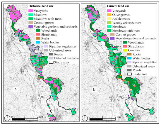
Figure 5.
Land-use maps obtained through photointerpretation: (a) historical land-use map (HLU); (b) current land-use map (CLU).
Indeed, as reported in Table 3, in the area in which the photointerpretation of HLU was possible, the historical vineyards represented the most extended land use (146.6 ha) and all of them were characterized by the traditional vine-breeding technique. They were followed by woodlands (138.5 ha), meadows (92.77 ha), and meadows with trees (31 ha). Urbanized areas occupied 46.2 ha. Some signs of the abandonment processes were also present but contained since shrublands covered only 12.03 ha. The other land uses were less represented.
Table 3.
Areas and percentages of the study area covered by the different historical land use (HLU) and current land use (CLU).
In recent times, considering the area in which the comparison with HLU was possible, the surface of vineyards decreased to 69.55 ha, while that of the woodlands increased (166.23 ha). Additionally, the area of the meadows increased (109.92 ha), while meadows with trees are nowadays less extended than in the past (18.14 ha). Strictly connected with the abandonment processes, the area of shrublands also increased (20.41 ha). During the considered period, we did not verify a great urban expansion, and the surface of urbanized areas covers nowadays 64.7 ha. Some new land uses were observed. The most extended was represented by the olive groves (7.45 ha) followed by the arable crops (5.04 ha). Woody arboriculture and conifers were introduced in only one field each, covering 0.25 ha and 0.16 ha, respectively. The area of chestnut groves was unchanged (3.24 ha).
Considering the total study area, nowadays woodlands represent the first land use for extension (182.92 ha), followed by meadows (123.03 ha) and vineyards (75.77 ha). Even though the vineyards’ areas decreased by about half, they remain the main arboreous crop that characterizes the terraced landscape of the study area. Shrublands cover 22.25 ha. The total surface covered by olive groves is 7.94 ha. Urbanized areas account for 68.88 ha. Regarding the vine-breeding technique, the persistence of the traditional pergolas account for the 94.7% of the vineyard surface; however, in the 5.3% of the total current vineyard surface the introduction of the espalier vine-breeding technique, which has no historical values, was observed.
Regarding the stone elements, we identified 98.34 km of dry-stone walls not covered by woodlands. At the same time, we identified 6138 stone columns once used for the support of the vine pergolas on lands not yet covered by woodlands. Figure 6 shows the maps of the stone elements obtained through photointerpretation in 2018.
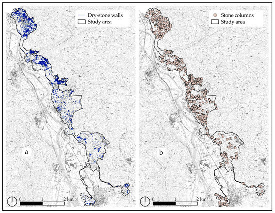
Figure 6.
Maps of the stone elements in 2018: (a) dry-stone walls not covered by woodlands; (b) stone columns once used for the support of the vine pergolas on lands not yet covered by woodlands.
3.2. The Dynamics of Landscape Change
The process of overlapping of the historical land-use map and the current land-use map allowed us to analyze the dynamics occurring from the middle of the last century to nowadays (from 1954 for the southern part of the study area and 1968 for the northern to 2018, Figure 4). Figure 7 reports the cross tabulation that allows to understand all of the transformations for each land-use class. We found that the 146.6 hectares of the historical vineyards were unchanged for 67.34 ha, while the others evolved principally in meadows (33.98 ha), woodlands (21.23 ha), and shrublands (10.92 ha). Of the vineyards, 5.78 ha changed into olive groves. This new land use appeared almost exclusively in place of vineyards. Additionally, the only field currently occupied by conifers (0.16 ha) historically was dedicated to viticulture. Meadows were unchanged for 62.92 ha. The difference evolved mainly in urbanized areas (8.81 ha), woodlands (7.69 ha), arable crops (4.18), and shrublands (2.67 ha). Only about the half of the historical meadows with trees remained unchanged (15.34 ha), while 8.53 ha evolved in woodlands and 4.01 ha evolved in meadows. Most of the woodlands did not undergo transformations (122.59 ha); only 8.47 ha evolved in meadows and 4.24 ha in urbanized areas. Most of the shrublands evolved in woodlands (6.19 ha), while 4.99 ha remained shrublands. The other land uses did not undergo relevant changes.
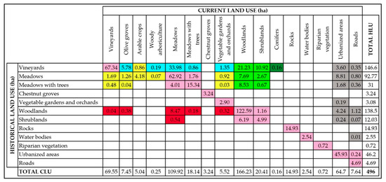
Figure 7.
Cross tabulation that shows the transformations occurring from the middle of the last century to nowadays (from 1954 for the southern part of the study area and 1968 for the northern to 2018, Figure 4). The colors of the cells are linked with the dynamics reported in the following figure.
All of these transformations generated some dynamics shown in Figure 8a. The principal of these is the unchanged areas which covered 74.82% of the study area. As we explained above, this dynamic also includes the transition from one land use to another belonging to the same macro-category (e.g., meadows and meadows with trees). Forestation is the second dynamic for extension (10.42%), followed by extensification (8.49%). As reported by cross-tabulation, both of them were mainly related to the abandonment of vineyards. The other dynamics were less represented: urbanization (4.32%), intensification (1.92%), deforestation (2%), and conifer reforestation (0.03%).
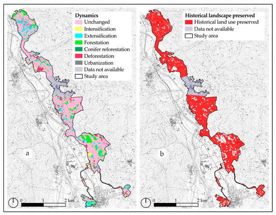
Figure 8.
(a) Map of the dynamics occurring from the middle of the last century to nowadays (from 1954 for the southern part of the study area and 1968 for the northern to 2018, Figure 4); (b) map of the historical landscape preserved.
The map reported in Figure 8b shows the historical landscape preserved, for which HLU = CLU. The 70.16% of the study area in which the comparison with HLU was possible is nowadays characterized by the same land use of the 1950s. This indicates a high level of historical landscape preserved.
3.3. The Landscape Indicators
The elaboration process of the HLU and CLU maps allowed us to observe a criticality that affected the study area in recent times: the land fragmentation. Particularly, referring to the area in which the comparison with HLU was possible, the number of patches increased from 1187 to 1848 and their average areas decreased from 0.42 ha to 0.27 ha. The medium agricultural surface decreased from 0.56 ha to 0.23 ha. Instead, the number of land uses increased from 12 to 16.
The fragmentation of the landscape mosaic also emerged from the edge density calculation. As shown in Table 4, at landscape level it increased from 781 m/ha to 997 m/ha. Vineyards represent the land-use class for which the ED increased more (from 603 m/ha to 1207 m/ha). Instead, for woodlands the ED decreased from 540 m/ha to 506 m/ha. These data confirmed the observed dynamics. Indeed, the forestation consequent to the abandonment processes rendered patches of woodlands bigger and homogeneous at the expense of the patches of vineyards, which are presently smaller and more fragmented than in the past.
Table 4.
The edge density for each land-use class and at the landscape level from the middle of the last century to nowadays (from 1954 for the southern part of the study area and 1968 for the northern to 2018, Figure 4).
The map and the graph of the historical index shown in Figure 9 categorize the historical land uses preserved for their risk of disappearance. Vineyards presented the highest historical index (2.11). Indeed, as seen above, it was the land use for which the surface decreased most during the time period considered. Meadows with trees constituted the second land use for the HI (1.72). Some land uses—water bodies, chestnut groves, rocks, and riparian vegetation—were not characterized by any area variations (HI = 1). The other land uses showed historical indexes <1 since they increased their areas from the middle of the last century to nowadays (from 1954 for the southern part of the study area and 1968 for the northern to 2018). Indeed, their increase is mainly due to the dynamics of forestation and urbanization.
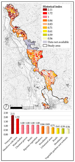
Figure 9.
Map and graph of the historical index.
4. Discussion
The assessment of the terraced landscape’s integrity in a dynamic perspective requires us to carry out multidimensional analysis, starting with diachronic analyses. The dynamics of the landscape must be analyzed and comprised without adopting a static, conservative approach. Indeed, as we explained above, the GIAHS-FAO approach recognizes the coevolution between humans and rural landscapes as the starting point for the livelihood of the former and the dynamic conservation of the latter. Since the landscape and seascape features constitute one of the criteria for a GIAHS proposal, the identification of the permanence of the stone elements in a terraced landscape is critical to assess its integrity. Additionally, the fragmentation of the landscape could affect its integrity because it exposes it to further abandonment processes. For these reasons, we analyzed the different elements able to influence the landscape’s integrity in a unique vineyard terraced landscape.
The first phase of our research was the photointerpretation of the IGMI aerial images and of the AGEA orthophoto. It allowed us to obtain a historical land-use map and a current land-use map with a high level of detail. The former showed that in the middle of the last century (1954 for the southern part of the study area and 1968 for the northern), vineyards were the first land-use class for extension, while the latter highlighted that, nowadays (2018), woodlands are the land use most represented in absolute values. However, vineyards remain the most extended arboreous crop. These data are consistent with other studies, which highlighted at the international level a reduction of the cultivated terraces consequent of the abandonment processes, occurred from the second half of the 1900s. For example, the areas of terraced vineyards in Costa Viola (Italy) showed a dramatic decrease (−88.79%) from 1955 to 2014 caused by the abandonment of the agriculture with the consequent forestation of the terraces [59]. Poyatos et al. [60] observed that during the second half of the 1900s (1957–1996), in the catchment of Cal Rodò (Catalonia, Spain), the surface of the cultivated terraced landscape decreased, while that of the spontaneous woodlands increased (+24%).
According to the literature cited above, the study of the historical and of the current land uses was the first step that allowed us to assess the integrity with a dynamic perspective of the terraced landscape of the study area. The process of overlapping of the two produced maps highlighted the dynamics occurring during the considered time period. Through cross-tabulation, we determined all of the changes of the land use. Kizos et al. [61] reported different situations consequent of the abandonment of the terraced traditional cultivations in Lesvos (Greece), mainly related to the total abandonment of fields, with the invasion of shrubs and woodlands, and with the change of cultivations. We also observed an intermedium situation with the loss of the historical cultivation but the continuous management of the terraces. Indeed, our research showed that the main part of the 79.26 ha of terraced vineyards lost evolved with the dynamic of extensification in meadows (42.9%), which are continuously mowed and managed (Figure 10a). The main changes that follow—forestation by woodlands (26.8%) and shrublands (13.8%)—are the most dangerous because they consist of the total abandonment of the terraced system, less or more recently, respectively (Figure 10b). Indeed, the total lack of management of the terraces causes several problems of hydrogeological risk [62]. The introduction of new cultivations (e.g., the olive groves shown in Figure 10c) were less extended (7.3%) and related to the dynamic of extensification. As cited above, we observed other dynamics (e.g., conifer reforestation) that are very underrepresented, but that concur with the landscape’s integrity loss (Figure 10d). Indeed, all of these dynamics change the landscape and threaten its integrity. However, in the study area, we observed that the dynamics of change represented only 25.18% of the area. A similar trend was observed by De Pasquale et al. [63] in the terraced landscape of Vallecorsa (Lazio, Italy), which is inscribed in the National Register of the Historical Rural Landscapes. Indeed, they reported that from 1954 to 2012 the historical landscape was unchanged for the 71% of the considered area, and that the other dynamics were less represented and mainly related to the abandonment of the traditional cultivations.
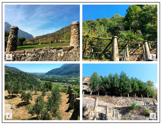
Figure 10.
The loss of the landscape’s integrity consequent of the abandonment of the vineyards and the dynamics of the land-use change: (a) meadows continuously mowed and managed (extensification), (b) woodlands and shrublands suffering from the total abandonment of the terraced system (forestation), (c) introduction of olive groves (extensification), and (d) conifer reforestation. In all of these cases, the stone columns once used for the support of the pergola caremiese lost their function but remained as historical landmarks of the landscape.
The results suggested that the historical landscape mosaic is well recognizable in the study area, since the 70.16% of the historical landscape of the middle of the last century is nowadays preserved (HLU = CLU). Agnoletti et al. [64] identified six classes of integrity according to the percentage of historical land use preserved: I (0–19%), II (20–34%), III (35–49%), IV (50–64%), V (65–79%), and VI (80–100%). The first class indicates that the historical landscape has almost disappeared, while the sixth class indicates a very high permanence of the historical landscape. The belonging of the landscape to the fifth class of the integrity satisfies the parameters to justify its admittance in the National Register (at least the 50% of the historical landscape preserved). It also makes the landscape a potential GIAHS-FAO site because it indicates that the traditional agroforestry system is well preserved and able to guarantee the livelihood of the rural community.
In our research, we further explored the parameter of integrity. Indeed, in addition to the study of the landscape changes, the scientific community recognizes the importance of analyzing the structure and the main features of the landscape in order to assess its integrity [65]. It is also a key point of the GIAHS program as, as we discussed above, the five criteria to be assessed include the analysis of the landscape and seascape features. We identified the stone elements characterizing the landscape that were possible to identify trough photointerpretation: the dry-stone walls and the stone columns once used for the support of the vine pergolas. Obviously, it was possible to identify them only in the terraced surfaces not covered by woodlands, but their quantification allowed us to understand their importance as features of the historical landscape. So, the estimation of 98.34 km of dry-stone walls is an underestimation because many terraces where the abandonment caused the spontaneous colonization of woodlands cannot be found through photointerpretation. However, the data show the extension of the dry-stone walls that are nowadays managed as in the past and that concur with the maintenance of the landscape’s integrity. This result allowed also to increase the knowledge about the Italian extension of the dry-stone walls, for which the literature is lacking [66]. Similarly, we identified the stone columns that lost their role of support of the vine’s pergolas (Figure 10), because the others are covered by pergolas and are not photo-interpretable. Furthermore, we identified those located in meadows consequent of the extensification, while woodlands consequent of the forestation cover them. We identified 6138 stone columns. It is an underestimation that, however, allowed us to understand their enormous and uncountable presence in the study area. These stone columns are a very important heritage, and unique in the world. However, the high number of stone columns which lost their role negatively affects the parameter of integrity because it indicates the historical presence of vine pergolas that have nowadays disappeared. Nowadays, these columns are recognizable and in a good state of conservation but if future planning policies do not support the restoration of the historical pergolas they are in danger of disappearing, and will either be invaded by woodlands or destroyed. Unfortunately, the poor quality of the IGMI’s aerial images did not allowed us to make a comparison between the two considered time periods regarding the stone elements, and their impact on the landscape’s integrity was based on their current state of conservation analyzable by photointerpretation.
Instead, diachronic analysis was possible for the vine-breeding technique that showed a very high integrity. Indeed, we observed that the traditional pergola caremiese vine-breeding technique during the middle of the last century was the only vine-breeding technique used in the study area. Nowadays, we observed the introduction of a new vine-breeding technique: the espalier. Its presence is limited to a little-extended area (only the 5.3% of the total area of vineyards) in the lower part of the slopes where the surfaces of the terraces are more extended (Figure 11a,b). It allows reducing the efforts and costs in term of hours of work for the cultivation of vineyards [67]. Additionally, also in this case the stone columns once used for the support of pergolas remain but have lost their role. Santoro et al. [68] reported a similar situation with the introduction of rows instead of the traditional pergolas in Cinque Terre (Liguria, Italy), which is a site recognized by UNESCO. They highlighted that the trend is in common with the most of the modern vineyards in Europe and that pergolas completely covering the terrain have an important role in soil erosion containment during rainfall events. For these reasons, the development of policies and action plans useful to recognize the added value for the wine produced through the traditional practices is the first step to make maintenance more convenient to winegrowers in the face of greater efforts. According to this, Torquati et al. [69] highlighted that the preservation of the landscape can be an important driving force to improve the income of winegrowers.
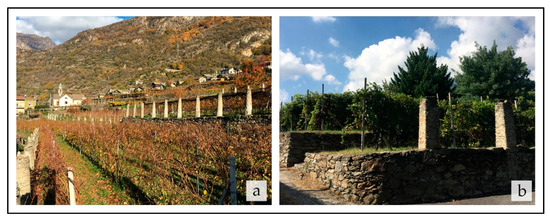
Figure 11.
(a) The introduction in the lower part of the slopes of the espalier vine-breeding technique in place of the traditional pergola caremiese, which causes a loss of the landscape’s integrity. Additionally, the stone columns once used for the support of pergolas remain but have lost their role. (b) Detail of terraces where the historical vine-breeding technique was changed causing the loss of the landscape’s integrity.
Another aspect that can affect the integrity of the landscape is the fragmentation of the patches that compose it. We observed that during the considered time period the number of the patches increased and their average area decreased. A similar trend was observed in a Portuguese rural landscape from 1979 and 2002 [70]. The fragmentation of the landscape also emerged in the edge density, which increased most for vineyards compared with the other land uses. Future planning strategies have to favor the consolidation of the fields because the fragmentation and the lack of management expose the terraced systems to multiple problems. The scientific community recognizes that this is a challenge to reduce the social and environmental downsides related to the fragmentation processes [71]. Indeed, for example, the fragmentation of the properties increases the time and costs for the winegrowers during their cultivation activities because they often have to cultivate small vineyards which are distant from each other. At the same time, the abandoned vineyards expose the other neighbors to the increase of phytosanitary problems. Indeed, Ripamonti et al. [72] observed, in the abandoned wild vineyards of the southern Piedmont, a higher presence of the Flavescence dorée of grapevine phytoplasma and its vector Scaphoideus titanus, which could affect the neighbors managed vineyards. The Piedmont Region has supported the land consolidation and the recovery of the abandoned fields since 2016 [73]. The adhesion of the study area to national and international programs goes in the direction of its enhancement. Indeed, even if today the integrity of the vineyard terraced landscape considered is good, it is threatened by some criticalities that were observed (abandonment processes and changing of the traditional vine-breeding technique), which are in common with other rural sites in Europe. For this reason most of the authors underlined the need of new policies and future planning strategies aimed at enhance the historical rural landscapes [74,75].
Since the GIAHS approach requires the development of an action plan for the dynamic conservation of the inscribed sites, we identified the land use that requires more attention in the future planning strategies in order to maintain the terraced landscape’s integrity. As reported above, the greatest value of the historical index was shown by vineyards (2.11). Indeed, they constitute the land use which most reduced its area during the considered time period. For these reasons, the enhancement of vineyards and the maintenance of the traditional agricultural practices are the first steps for the enhancement of the entire terraced landscape.
5. Conclusions
The research proposed a GIS-based approach to assess the integrity of a potential GIAHS-FAO site with a dynamic perspective. We applied it in a unique vineyard terraced landscape located in Northwest Piedmont (Italy) characterized by vine pergolas supported by stone columns. We analyzed the dynamics of the landscape’s mosaic occurring from the middle of the last century to nowadays. The parameter of integrity was explored starting from the land-use changes occurring from 1954 for the southern part of the study area and 1968 for the northern to 2018. The elements that allowed quantifying it were analyzed. The GIS-based approach allowed us to obtain data that were previously unknown, since the available regional cartography was acquired with a less detailed scale. The limit of the approach is that it is strictly connected with the availability of the historical aerial images and their level of definition. The strength is due to the possibility to use its detailed results not only to assess the landscape’s integrity but also to influence future planning strategies and policies.
In this direction, the GIAHS program could support the dynamic conservation of the study area. Indeed, its approach recognizes that the rural landscape has not to be considered as a static museum but as a live system coevolved with the rural communities. In this context, the sporadic introduction of new crops (e.g., olive groves) or the limited adaptation of the historical vine-breeding technique to more modern needs could be accepted. On the contrary, future planning strategies will have to be much more attractive for winegrowers in terms of the maintenance of traditional cultivation (vineyards), and agricultural practices (traditional pergola caremiese). Some useful strategies could be to recognize the quality of the historical landscape participating to the national and international programs of enhancement; to involve the recovery of the abandoned vineyards’ terraced landscapes; to support the reconstruction of damaged dry-stone walls; to prioritize the recovery of the stone columns, which are important landmarks of the landscape; and to invest resources to attract experiential tourism. The good current terraced landscape’s integrity, which is an important starting point, merged with these indications will allow the landscape to guarantee the livelihood of future generations as in the past. It is an important capability that a potential GIAHS-FAO site has to show.
Author Contributions
Conceptualization, E.P., M.D. and F.L.; methodology, E.P. and F.L.; software, E.P.; validation, E.P., M.D. and F.L.; formal analysis, E.P.; investigation, E.P.; data curation, E.P.; writing—original draft preparation, E.P., M.D. and F.L.; visualization, E.P.; supervision, M.D. and F.L. All authors have read and agreed to the published version of the manuscript.
Funding
This research received no external funding.
Data Availability Statement
Not applicable.
Acknowledgments
We thank the Unione Montana Mombarone and the Municipalities of Borgofranco di Ivrea, Carema, Nomaglio, and Settimo Vittone for their support.
Conflicts of Interest
The authors declare no conflict of interest.
References
- Bastian, O.; Walz, U.; Decker, A. Historical landscape elements: Part of our cultural heritage—A methodological study from Saxony. In The Carpathians: Integrating Nature and Society Towards Sustainability. Environmental Science and Engineering; Springer: Berlin/Heidelberg, Germany, 2013; pp. 441–459. [Google Scholar]
- Agnoletti, M.; Rotherham, I.D. Landscape and biocultural diversity. Biodivers. Conserv. 2015, 24, 3155–3165. [Google Scholar] [CrossRef]
- Cots-Folch, R.; Martínez-Casasnovas, J.A.; Ramos, M. Agricultural trajectories in a Mediterranean mountain region (Priorat, NE Spain) as a consequence of vineyard conversion plans. Land Degrad. Dev. 2009, 20, 1–13. [Google Scholar] [CrossRef]
- Patel, S.K.; Sharma, A.; Singh, G.S. Traditional agricultural practices in India: An approach for environmental sustainability and food security. Energy Ecol. Environ. 2020, 5, 253–271. [Google Scholar] [CrossRef]
- Agnoletti, M.; Manganelli, S.; Piras, F. COVID-19 and rural landscape: The case of Italy. Landsc. Urban Plan. 2020, 204, 103955. [Google Scholar] [CrossRef] [PubMed]
- Rotondi, A.; Fabbri, A.; Ganino, T.; Beghè, D.; Magli, M.; Morrone, L. Genetic and Landscape Characterization of Ancient Crops: The Olive Tree, a Case Study in Northern Italy. In Exploring and Optimizing Agricultural Landscapes. Innovations in Landscape Research; Springer: Cham, Switzerland, 2021; pp. 457–477. [Google Scholar]
- Bhaskar, B.; Maske, S.; Gaikwad, S.; Chaturvedi, A.; Prasad, J.; Anantwar, S.; Singh, S. Soil and land resource evaluation for rural agricultural land use planning—A case study from hot semiarid ecosystem of Western India. Arch. Agric. Environ. Sci. 2017, 2, 206–218. [Google Scholar]
- Tarolli, P.; Preti, F.; Romano, N. Terraced landscapes: From an old best practice to a potential hazard for soil degradation due to land abandonment. Anthropocene 2014, 6, 10–25. [Google Scholar] [CrossRef]
- Brown, A.G.; Fallu, D.; Walsh, K.; Cucchiaro, S.; Tarolli, P.; Zhao, P.; Pears, B.R.; van Oost, K.; Snape, L.; Lang, A. Ending the Cinderella status of terraces and lynchets in Europe: The geomorphology of agricultural terraces and implications for ecosystem services and climate adaptation. Geomorphology 2021, 379, 107579. [Google Scholar] [CrossRef]
- Paliaga, G.; Luino, F.; Turconi, L.; de Graff, J.V.; Faccini, F. Terraced landscapes on Portofino Promontory (Italy): Identification, geo-hydrological hazard and management. Water 2020, 12, 435. [Google Scholar] [CrossRef]
- Gullino, P.; Beccaro, G.L.; Larcher, F. Assessing and monitoring the sustainability in rural world heritage sites. Sustainability 2015, 7, 14186–14210. [Google Scholar] [CrossRef]
- Fayet, C.M.; Reilly, K.H.; van Ham, C.; Verburg, P.H. What is the future of abandoned agricultural lands? A systematic review of alternative trajectories in Europe. Land Use Policy 2022, 112, 105833. [Google Scholar] [CrossRef]
- Shirvani Dastgerdi, A.; Kheyroddin, R. Policy Recommendations for Integrating Resilience into the Management of Cultural Landscapes. Sustainability 2022, 14, 8500. [Google Scholar] [CrossRef]
- Gkoltsiou, A.; Athanasiadou, E.; Paraskevopoulou, A.T. Agricultural Heritage Landscapes of Greece: Three Case Studies and Strategic Steps towards Their Acknowledgement, Conservation and Management. Sustainability 2021, 13, 5955. [Google Scholar] [CrossRef]
- Italian Ministry of Agricultural, Food and Forestry Policies—Decree nr. 17070—19 November 2012. Available online: https://www.politicheagricole.it/flex/cm/pages/ServeBLOB.php/L/IT/IDPagina/5832 (accessed on 10 September 2022).
- Agnoletti, M. Italian historical rural landscapes: Dynamics, data analysis and research findings. In Italian Historical Rural Landscapes. Environmental History (1); Springer: Dordrecht, The Netherlands, 2013; pp. 3–87. [Google Scholar]
- Rete Rurale Nazionale—National Register of Historical Rural Landscapes. Available online: https://www.reterurale.it/registropaesaggi (accessed on 10 September 2022).
- Agnoletti, M.; Santoro, A. The Italian National Register of Historical Rural Landscapes. In Cultural Heritage—Possibilities for Land-Centered Societal Development. Environmental History (13); Springer: Cham, Switzerland, 2022; pp. 15–34. [Google Scholar]
- Kajihara, H.; Zhang, S.; You, W.; Min, Q. Concerns and opportunities around cultural heritage in east Asian globally important agricultural heritage systems (GIAHS). Sustainability 2018, 10, 1235. [Google Scholar] [CrossRef]
- Silva-Pérez, R.; González-Romero, G. GIAHS as an Instrument to Articulate the Landscape and Territorialized Agrifood Systems—The Example of La Axarquía (Malaga Province, Spain). Land 2022, 11, 310. [Google Scholar] [CrossRef]
- Bixia, C.; Zhenmian, Q. Green tourism in Japan: Opportunities for a GIAHS pilot site. J. Resour. Ecol. 2013, 4, 285–292. [Google Scholar] [CrossRef]
- Lun, Y.; Jianhui, Y.; Wenjun, J.; Moucheng, L.; Wenhua, L. The evaluation of food and livelihood security in a Globally Important Agricultural Heritage Systems (GIAHS) site. J. Resour. Ecol. 2021, 12, 480–488. [Google Scholar] [CrossRef]
- Agnoletti, M.; Santoro, A. Agricultural heritage systems and agrobiodiversity. Biodivers. Conserv. 2022, 31, 2231–2241. [Google Scholar] [CrossRef]
- Koohafkan, P.; Altieri, M.; Initiative, G. A methodological framework for the dynamic conservation of agricultural heritage systems. In Land and Water Division; The Food and Agriculture Organization (FAO) of the United Nations: Geneva, Switzerland, 2011; pp. 1–61. [Google Scholar]
- Jiao, W.; Yang, X.; Min, Q. A Review of the Progress in Globally Important Agricultural Heritage Systems (GIAHS) Monitoring. Sustainability 2022, 14, 9958. [Google Scholar] [CrossRef]
- Fuller, A.M.; Min, Q.; Jiao, W.; Bai, Y. Globally Important Agricultural Heritage Systems (GIAHS) of China: The challenge of complexity in research. Ecosyst. Health Sustain. 2015, 1, 1–10. [Google Scholar] [CrossRef]
- Guidelines for Developing a GIAHS Proposal Document. Available online: https://www.fao.org/giahs/become-a-giahs/designation-process/en/ (accessed on 10 September 2022).
- Globally Important Agricultural Heritage Systems. Available online: https://www.fao.org/giahs/giahsaroundtheworld/en/ (accessed on 10 September 2022).
- UNESCO World Heritage List. Available online: https://whc.unesco.org/en/list/?&type=cultural (accessed on 10 September 2022).
- Gullino, P.; Larcher, F. Integrity in UNESCO World Heritage Sites. A comparative study for rural landscapes. J. Cult. Herit. 2013, 14, 389–395. [Google Scholar] [CrossRef]
- Boltižiar, M.; Olah, B. Land use changes of UNESCO Biosphere reserves in the Slovak Carpathians since the late eighteenth century. In The Carpathians: Integrating Nature and Society towards Sustainability. Environmental Science and Engineering; Springer: Berlin/Heidelberg, Germany, 2013; pp. 377–391. [Google Scholar]
- Khalaf, R.W. The implementation of the UNESCO World Heritage Convention: Continuity and compatibility as qualifying conditions of integrity. Heritage 2020, 3, 384–401. [Google Scholar] [CrossRef]
- García-Esparza, J.A. Are World Heritage concepts of integrity and authenticity lacking in dynamism? A critical approach to Mediterranean autotopic landscapes. Landsc. Res. 2018, 43, 817–830. [Google Scholar] [CrossRef]
- Wenjun, J.; Bojie, W.; Yehong, S.; Moucheng, L. Design and application of the annual report of Globally Important Agricultural Heritage Systems (GIAHS) monitoring. J. Resour. Ecol. 2021, 12, 498–512. [Google Scholar] [CrossRef]
- Pomatto, E.; Devecchi, M.; Larcher, F. Coevolution between Terraced Landscapes and Rural Communities: An Integrated Approach Using Expert-Based Assessment and Evaluation of Winegrowers’ Perceptions (Northwest Piedmont, Italy). Sustainability 2022, 14, 8624. [Google Scholar] [CrossRef]
- UNESCO—Intangible Cultural Heritage. Available online: https://ich.unesco.org/en/RL/art-of-dry-stone-walling-knowledge-and-techniques-01393 (accessed on 12 September 2022).
- Agnoletti, M. The development of a historical and cultural evaluation approach in landscape assessment: The dynamic of Tuscan landscape between 1832 and 2004. In The Conservation of Cultural Landscapes; CABI: Wallingford, UK, 2006; pp. 3–41. [Google Scholar]
- Jaworek-Jakubska, J.; Filipiak, M.; Napierała-Filipiak, A. Understanding of Forest Cover Dynamics in Traditional Landscapes: Mapping Trajectories of Changes in Mountain Territories (1824–2016), on the Example of Jeleniogórska Basin, Poland. Forests 2020, 11, 867. [Google Scholar] [CrossRef]
- Zeleke, G.; Hurni, H. Implications of land use and land cover dynamics for mountain resource degradation in the Northwestern Ethiopian highlands. Mt. Res. Dev. 2001, 21, 184–191. [Google Scholar] [CrossRef]
- Díaz-Pacheco, J.; García-Palomares, J.C. A highly detailed land-use vector map for Madrid region based on photo-interpretation. J. Maps 2014, 10, 424–433. [Google Scholar] [CrossRef]
- Lister, T.W.; Lister, A.J.; Alexander, E. Land use change monitoring in Maryland using a probabilistic sample and rapid photointerpretation. Appl. Geogr. 2014, 51, 1–7. [Google Scholar] [CrossRef]
- Monteiro, M.; Tavares, A.O. What is the influence of the planning framework on the land use change trajectories? Photointerpretation analysis in the 1958–2011 period for a medium/small sized city. Sustainability 2015, 7, 11727–11755. [Google Scholar] [CrossRef]
- Brandolini, P. The outstanding terraced landscape of the Cinque Terre coastal slopes (eastern Liguria). In Landscapes and Landforms of Italy. World Geomorphological Landscapes; Springer: Cham, Switzerland, 2017; pp. 235–244. [Google Scholar]
- Italian Ministry of Agricultural, Food and Forestry Policies—Decree nr. 6899—30 June 2020. Available online: https://www.politicheagricole.it/flex/cm/pages/ServeBLOB.php/L/IT/IDPagina/15621 (accessed on 15 September 2022).
- Italian Military Geographic Institute. Available online: httpss://www.igmi.org/en (accessed on 9 January 2020).
- Cartographic Geoportal of the Piedmont Region. Available online: https://www.geoportale.piemonte.it/cms/ (accessed on 9 January 2020).
- Rizzo, M.; Gasparini, P. Land Use and Land Cover Photointerpretation. In Italian National Forest Inventory—Methods and Results of the Third Survey. Springer Tracts in Civil Engineering; Springer: Cham, Switzerland, 2022; pp. 49–66. [Google Scholar]
- Popovici, E.A.; Bălteanu, D.; Kucsicsa, G. Assessment of changes in land-use and land-cover pattern in Romania using Corine Land Cover Database. Carpathian J. Earth Environ. Sci. 2013, 8, 195–208. [Google Scholar]
- Feranec, J.; Soukup, T.; Hazeu, G.; Jaffrain, G. European Landscape Dynamics: CORINE Land Cover Data; CRC Press: Boca Raton, FL, USA, 2016. [Google Scholar]
- Feranec, J.; Hazeu, G.; Christensen, S.; Jaffrain, G. Corine land cover change detection in Europe (case studies of The Netherlands and Slovakia). Land Use Policy 2007, 24, 234–247. [Google Scholar] [CrossRef]
- Vaitkus, G.; Vaitkuvienė, D. Land cover changes in the Lithuanian coastal zone during 1975–2000. Acta Zool. Litu. 2005, 15, 183–187. [Google Scholar] [CrossRef]
- Piedmont Region’s Regional Law nr. 4–10 February 2009. Available online: Htt://arianna.cr.piemonte.it/iterlegcoordweb/dettaglioLegge.do?urnLegge=urn%3Anir%3Aregione.piemonte%3Alegge%3A2009-02-10%3B4%402021-10-21 (accessed on 9 January 2020).
- Agnoletti, M. The degradation of traditional landscape in a mountain area of Tuscany during the 19th and 20th centuries: Implications for biodiversity and sustainable management. For. Ecol. Manag. 2007, 249, 5–17. [Google Scholar] [CrossRef]
- Girvetz, E.H.; Thorne, J.H.; Berry, A.M.; Jaeger, J.A. Integration of landscape fragmentation analysis into regional planning: A statewide multi-scale case study from California, USA. Landsc. Urban Plan. 2008, 86, 205–218. [Google Scholar] [CrossRef]
- Deng, J.S.; Wang, K.; Hong, Y.; Qi, J.G. Spatio-temporal dynamics and evolution of land use change and landscape pattern in response to rapid urbanization. Landsc. Urban Plan. 2009, 92, 187–198. [Google Scholar] [CrossRef]
- Gautam, A.P.; Webb, E.L.; Shivakoti, G.P.; Zoebisch, M.A. Land use dynamics and landscape change pattern in a mountain watershed in Nepal. Agric. Ecosyst. Environ. 2003, 99, 83–96. [Google Scholar] [CrossRef]
- Ode, Å.; Miller, D. Analysing the relationship between indicators of landscape complexity and preference. Environ. Plan. B Plan. Des. 2011, 38, 24–40. [Google Scholar] [CrossRef]
- Tang, J.; Wang, L.; Yao, Z. Analyses of urban landscape dynamics using multi-temporal satellite images: A comparison of two petroleum-oriented cities. Landsc. Urban Plan. 2008, 87, 269–278. [Google Scholar] [CrossRef]
- Modica, G.; Praticò, S.; Di Fazio, S. Abandonment of traditional terraced landscape: A change detection approach (a case study in Costa Viola, Calabria, Italy). Land Degrad. Dev. 2017, 28, 2608–2622. [Google Scholar] [CrossRef]
- Poyatos, R.; Latron, J.; Llorens, P. Land use and land cover change after agricultural abandonment. Mt. Res. Dev. 2003, 23, 362–368. [Google Scholar] [CrossRef]
- Kizos, T.; Dalaka, A.; Petanidou, T. Farmers’ attitudes and landscape change: Evidence from the abandonment of terraced cultivations on Lesvos, Greece. Agric. Hum. Values 2010, 27, 199–212. [Google Scholar] [CrossRef]
- Agnoletti, M.; Errico, A.; Santoro, A.; Dani, A.; Preti, F. Terraced landscapes and hydrogeological risk. Effects of land abandonment in Cinque Terre (Italy) during severe rainfall events. Sustainability 2019, 11, 235. [Google Scholar] [CrossRef]
- De Pasquale, G.; Livia, S. Biocultural diversity in the traditional landscape of Vallecorsa. Biodivers. Conserv. 2022, 31, 2373–2396. [Google Scholar] [CrossRef]
- Agnoletti, M.; Emanueli, F.; Corrieri, F.; Venturi, M.; Santoro, A. Monitoring traditional rural landscapes. The case of Italy. Sustainability 2019, 11, 6107. [Google Scholar] [CrossRef]
- Agnoletti, M.; Santoro, A.; Gardin, L. Assessing the integrity of the historical landscapes. In Italian Historical Rural Landscapes. Environmental History; Springer: Dordrecht, Holland, 2013; pp. 89–130. [Google Scholar]
- Bonardi, L.; Varotto, M. Paesaggi Terrazzati d’Italia. Eredità Storiche e Nuove Prospettive; FrancoAngeli: Milan, Italy, 2016. [Google Scholar]
- Mazzarino, S. Il mercato dei vini da uve “Nebbiolo”. In Quaderni di Scienze Viticole ed Enologiche dell’Università di Torino; University of Turin: Turin, Italy, 2006; Volume 28, pp. 207–222. [Google Scholar]
- Santoro, A.; Venturi, M.; Agnoletti, M. Landscape perception and public participation for the conservation and valorization of cultural landscapes: The case of the Cinque Terre and Porto Venere UNESCO site. Land 2021, 10, 93. [Google Scholar] [CrossRef]
- Torquati, B.; Giacchè, G.; Venanzi, S. Economic analysis of the traditional cultural vineyard landscapes in Italy. J. Rural Stud. 2015, 39, 122–132. [Google Scholar] [CrossRef]
- Pôças, I.; Cunha, M.; Pereira, L.S. Remote sensing based indicators of changes in a mountain rural landscape of Northeast Portugal. Appl. Geogr. 2011, 31, 871–880. [Google Scholar] [CrossRef]
- Gulinck, H.; Wagendorp, T. References for fragmentation analysis of the rural matrix in cultural landscapes. Landsc. Urban Plan. 2002, 58, 137–146. [Google Scholar] [CrossRef]
- Ripamonti, M.; Pegoraro, M.; Rossi, M.; Bodino, N.; Beal, D.; Panero, L.; Marzachì, C.; Bosco, D. Prevalence of Flavescence dorée phytoplasma-infected Scaphoideus titanus in different vineyard agroecosystems of Northwestern Italy. Insects 2020, 11, 301. [Google Scholar] [CrossRef]
- Piedmont Region—Regional law nr. 21—2 November 2016. Available online: https://regione.piemonte.it/governo/bollettino/abbonati/2016/44/attach/l201621_agri.pdf (accessed on 12 October 2022).
- Zomeni, M.; Tzanopoulos, J.; Pantis, J.D. Historical analysis of landscape change using remote sensing techniques: An explanatory tool for agricultural transformation in Greek rural areas. Landsc. Urban Plan. 2008, 86, 38–46. [Google Scholar] [CrossRef]
- Lomba, A.; Guerra, C.; Alonso, J.; Honrado, J.P.; Jongman, R.; McCracken, D. Mapping and monitoring high nature value farmlands: Challenges in European landscapes. J. Environ. Manag. 2014, 143, 140–150. [Google Scholar] [CrossRef] [PubMed]
Publisher’s Note: MDPI stays neutral with regard to jurisdictional claims in published maps and institutional affiliations. |
© 2022 by the authors. Licensee MDPI, Basel, Switzerland. This article is an open access article distributed under the terms and conditions of the Creative Commons Attribution (CC BY) license (https://creativecommons.org/licenses/by/4.0/).