Article

Land Evaluation for Acacia (Acacia mangium × Acacia auriculiformis) Plantations in the Mountainous Regions of Central Vietnam

1
International School–Hue University, Hue 52000, Vietnam
2
Faculty of Land Resources and Agricultural Environment, University of Agriculture and Forestry, Hue University, Hue 52000, Vietnam
*
Author to whom correspondence should be addressed.
Land 2022, 11(12), 2184; https://doi.org/10.3390/land11122184
Submission received: 10 November 2022 / Revised: 25 November 2022 / Accepted: 29 November 2022 / Published: 1 December 2022

Abstract

:
In recent years, both scientists and local governments have been giving serious attention to land evaluation, especially in regard to the use of agricultural land. This is with the intention of increasing the sustainability of agricultural production. In Vietnam, acacia plantations play an important role in the livelihoods of farmers in mountainous regions. Therefore, identifying suitable areas for acacia plantations is an important consideration within mountainous areas. This research was conducted in Nam Dong district, Central Vietnam, using six physical soil criteria for land evaluation by the Analytic Hierarchy Process (AHP) and also the Fuzzy Analytic Hierarchy Process (FAHP). The results have shown that the ranking of selected criteria in both methods was the same, but the weighting of each criterion was different. Among the six physical soil criteria, soil depth has the highest priority, followed by slope, soil organic carbon content, soil texture, soil pH, and soil type. The suitability maps for acacia plantations within the area studied have shown that 9344 ha were not suitable, and 99 ha had low suitability for acacia plantation by both methods. For the AHP approach, 928 hectares were in the range of moderate suitability, and 3080 hectares were in the high suitability class. In contrast, the FAHP method determined 905 hectares to be of the moderate suitability class and 3102 hectares to be of the high suitability class. Based on the observed acacia’s productivity and the scores of the two methods, it shows that the FAHP has a stronger correlation than the of AHP. Within the six selected criteria, the FAHP method can increase the accuracy of land evaluation results by 4.62% in comparison to the original AHP method. Therefore, the FAHP is the most suitable method for land evaluation, especially for agricultural land planning. Further studies should be integrated into more social and economic criteria for comprehensive land evaluation scenarios.

1. Introduction

Due to the recent global concerns of climate change, land evaluation has become an increasingly important topic in agricultural research worldwide [1]. Land evaluation is an essential process in determining how to use a variety of agricultural land areas in the most effective way. This includes considerations in terms of economic, as well as environmental, and also in terms of livelihoods among various social demographics within a given area. This is based on the predictions of land performance over time and under specific uses [2,3]. The land evaluation should be conducted in a comprehensive way that takes into account the specific conditions of each research site. Academic institutions and individual researchers around the world have been working for many years to find appropriate ways to apply the methods of the land evaluation approach [4,5,6,7]. Some of the approaches that can be listed are as Multi-Criteria Decision Analyses (MCDA), based on the Analytic Hierarchy Process (AHP) within the framework of Land Evaluation of Food and Agriculture Organization (FAO), Land Capability Classification, Paramedic Indices, Empirical, and the Ideal Point approach [1,8]. Among these listed above, the AHP approach is still the most commonly applied method for land evaluation, especially in regard to specific study sites, with a specific land use type [9,10]. Some findings of previous researchers show that [11,12] the AHP method still has some limitations. Those are that the opinions of participants are subjective, and the evaluation process requires that the decision-maker express the participants’ preferences on a numeric scale. Moreover, there is often uncertainty in the weighting of criteria and the scoring of some specific attributes of each criterion. The AHP can tend to lack the ability to delineate between consequential vagueness in judgments that occurs during the conversion of verbal scales into numeric scale [13]. To overcome these limitations, a version of AHP, in combination with Fuzzy theory, has become common alternative in this type of research. These comnined techniques have been termd the Fuzzy Analytic Hierarchy Process (FAHP). Recent research found that the integration of Fuzzy and AHP helps to ensure the accuracy of the MCDA process [14,15]. Concerning land evaluation for agricultural land use, Gunal et al. (2022) found that FAHP combined with Geographical Information Systems (GIS) methods is an effective means by which to make decisions in agricultural land use planning [16]. Many Fuzzy AHP methods have been proposed by variety of researchrs based on the Fuzzy set theory, which was developed by Zadeh in 1965 [17,18]. The Fuzzy theory has been developed and integrated successfully into support systems for agriculture, such as that of determining nitrogen balance in the soil [19]. An interval judgment for the participants’ opinions in a given study was added to the calculation process, instead of having a fixed value. The common membership functions of a Fuzzy theory set were linear, triangular, and trapezoidal [20,21]. Among these, Triangular Fuzzy Numbers (TFNs) were preferred because of their simplicity to calculate and, also their usefulness in expressing and processing fuzzy logic. Therefore, many authors have used FAHP with TFNs to construct fuzzy pair-wise comparison matrices [22,23].
In recent years, the advancement of GIS technology in combination with certain mathematical models, has allowed for optimal use of data resources to evaluate land suitability in a comprehensive way that can include multiple factors. It provides assistance for statistics, analysis, planning, and management in both spatial and attribute databases [24,25]. Because of this development, the spatial data and soil characteristics stored in GIS are easier to develop into user-friendly automatic land evaluation tools [26]. The integration of GIS and MCDA for agricultural land evaluation has been applied by many researchers worldwide [27,28,29,30]. This integration is an excellent spatial analysis tool that facilitates the establishment of a comprehensive spatial database involving multi-criteria methodologies in land evaluation [16]. Therefore, the FAHP and GIS can be an effective method to enhance the accuracy of land suitability evaluation for a particular crop product [31].
Acacia (Acacia mangium × Acacia auriculiformis) is the most important tree in agricultural production in mountainous regions of Vietnam, especially in Central Vietnam [32]. Acacia plantations have emerged as an important resource for supporting the rural economy and national export revenue [33]. In the year 2015, Vietnam established 1.2 million ha of acacia plantations for wood production and more than half of these plantations were cultivated by small farms [34]. In Thua Thien Hue province, acacia has increased rapidly since the early 1990s due to scientific trials that have shown that the fast-growing nitrogen-fixing species of acacia could be readily grown on degraded soil even though it was previously an alien species to the areas in the question [35]. In 2006, acacia plantations covered more than 14% of the total land area in Thua Thien Hue province. The hybrid species between Acacia auriculiformis and Acacia mangium is the most popular in Central Vietnam in general and in Thua Thien Hue in particular. This is mainly due to the acacia tree’s fast growth and short rotation period, its ability to improve degraded land, and its potential to be developed into multiple products [36]. In Thua Thien Hue Province, acacia plantations can be cultivated along side protected natural forests in order to improve the livelihoods of local peoples as well as to increase forest cover, but also to allow damaged natural forests to regenerate without further exploitation [37].
Acacia plantations can have both negative and positive impacts within various areas. It is a land-use type that can potentially restore nutrient cycling in degraded soil but is highly invasive wherever it is planted [38]. Acacia plantations determination should be carefully undertaken in both methods and databases. However, although land evaluation is a popular process in agricultural land use studies, applying this process for acacia plantations is still rare. In Indonesia, Samsuri et al. (2019) have used 14 land characteristics to identify the land suitability for acacia in a region of North Sumatra, with more than 80% of the total area having the highest level of suitability [39]. This research has been conducted by combining the plant growth requirements with specific land characteristics. However, the suitability of each criterion in this research is referenced from the previous academic literature without the participation of land users who have a detailed experiential knowledge of the growth patterns of acacia on their lands. In Vietnam, several recent pieces of research have been conducted in relation to land evaluations for acacia. Nguyen et al. (2019) used five physical soil criteria in the AHP model to evaluate the suitability of each land unit for acacia plantations [40]. This research also creates a linear regression between land suitability and acacia yield. In the same year, Ronja et al. (2019) also used the AHP method to assess the suitability level of acacia plantations in the mountainous district of Central Vietnam [9]. Most of the above research has been carried out by the Boolean method and therefore needs to be included with other methods for comparison.
The cultivation of acacia in the mountainous regions of Thua Thien Hue Province still needs long-term strategic planning because the existing acacia plantation areas were planted based on farming experience and the subjective inclinations of individual households. These unpredictable factors disrupt the stability of the acacia wood market in general and cause harmful effects on existing production activities, especially for the mountainous regions. For example, planting acacia in inappropriate places leads to low economic efficiency. Therefore, our study was conducted in Nam Dong district, Thua Thien Hue Province, with the aim of (i) comparing the results of the land evaluation for acacia by the AHP method and FAHP method, (ii) proposing appropriate placements for acacia plantation in Nam Dong district.

2. Materials and Methods

2.1. Study Site

Nam Dong district is located in the southwestern part of Thua Thien Hue Province, Central Vietnam, between 107°28′ E to 107°54′ E and 15°47′ N to 16°17′ N. The geographical location of the Nam Dong district is shown in Figure 1. The terrain of Nam Dong is complex, and its elevation ranges from 50 to 600 m above sea level. The area of Nam Dong resembles a valley in that high mountains surround the region from the East, South, and West. This district has an area of 64,777 hectares, of which 48,000 ha are covered by protected forest, and 13,450 ha consists of agricultural land (including the forest areas dedicated to agricultural production). The remaining areas are residential and land under construction for social development. Within the agricultural land use types, the acacia accounts for the largest area with 9422 hectares, followed by rubber, rice, grass and shrub, and vegetables, respectively. The climate in Nam Dong district shows tropical monsoon characteristics with a heavy rainy season from September to November yearly. The precipitation in this region ranges from 2000 to 3000 mm per year, with an average of 2721 mm, as reported from 2010 to 2020. This district is one of two districts that receives slightly more precipitation than the remainder of Thua Thien Hue Province. The minimum temperature is as low as 12 °C in January and reaches it’s maximum of around 35 °C in June [41]. The climatic conditions have close relationships to soil moisture, and soil moisture also strongly affects acacia growth due to their rapid growth, driven by high photosynthetic and transpiration rates [42]. Recent research using the Standardized Precipitation Index and a rainfall dataset of the whole of Vietnam in the period of 1981 to 2019 indicated that our research site belongs to the wet soil moisture [43], and therefore, these climatic conditions are suitable for acacia plantations. Based on the international classification system for soil [44], there are five soil types within the entire Nam Dong district: Hyperferrali- Hyperdystric Acrisol (56,198 ha), Umbri- Ferric Acrisols (4865 ha), Dystric Fluvisols (2217 ha), Umbri-Hyperdystric Acrisols (1220 ha), and Plinthic Acrisols (241 ha). The Hyperferrali- Hyperdystric Acrisol is widely distributed everywhere in the district, while the Dystric Fluvisols are in small flat land areas and along the river systems. As of 2020, the population of Nam Dong was 27,500, of which nearly half are ethnic minority groups [45]. The population density is concentrated in the low-land areas in the district’s middle. Seventy percent of the local population relies on forest production for daily life. The households’ livelihoods depend on traditional activities such as agriculture, forestry, livestock, and wage labor. Acacia hybrid plantations, in particular, have been reported as one of the main contributors to the development of the residents’ livelihoods [46].

2.2. Methods

2.2.1. Focus Group Discussions

Group discussion is a widely used application within the MCDA methods [47]. The most vital purpose of group discussion is to establish an in-depth understanding of the personal opinions of each participant involved on relevant issues and then guide them toward a consensus [48]. The link between peoples’ perceptions and understanding of their natural and social environments is critical in decision-making on the treatment of those natural resources. Rectifying local opinions can be difficult due to the fact that many ordinary local people in these areas interpret the conditions of their immediate surroundings through a experimental lens rather than one that is scientifically based. This commonly held perception is based on experimental knowledge [49]. It is important to note, however, experimental knowledge is quite important in decision-making as it is also the result of continuous observation and experience of local natural environmental phenomena. Therefore, in this research, all participants were local residents and/or working for local agencies. As previous research indicated, the number of participants per focus group ranged from 2 to 21, with a mean of 10 participants [48]. We designed a group discussion with 15 participants, including five farmers, two officers from the Natural Resources and Environment Department, two officers from the Agriculture and Rural Development Department, four researchers from the University of Agriculture and Forestry, Hue University, who have expertise on soil and crop sciences in the mountainous regions of Thua Thien Hue Province, and two staff members from the Department of Economics.

2.2.2. Geographical Information System and Mapping

In this study, we used an existing soil map of Thua Thien Hue Province at a scale of 1/50,000 in the VN2000 coordinate system, 3 degrees with central longitude of 107° E [50]. The following layers from the soil map were extracted, including soil type, soil depth, soil texture, and slope of the terrain. All of these layers have been converted into coordinates of UTM-WGS 84, and N48 and stored as shape files. This research used the intersect function of ArcGIS 10.3 to create a Land Map Unit (LMU) from the spatial database and the final score of each land unit. The current land use types have been extracted from the current land use map in 2020 and the updated version of 2022 of the research site at a scale of 50,000. This spatial data was used to analyze the consistency of the results of the land evaluation with the current land use status and the plans for acacia plantations in the future. There are five land use types in the agricultural land use category: acacia, grasses and shrubs, rice, rubber, and vegetables. This study collected 95 soil samples for laboratory analysis to map the Soil Organic Carbon (SOC) and Soil acidity (Soil pH). The research collected 95 soil samples for laboratory analysis. The soil samples were collected in 2020, relying on a land use map and a grid sampling method of 1.5 km × 1.5 km. For each sample, soil material in the layer at 0–30 cm and the layer at 30–60 cm were collected from five points (North, South, East, West, and Center) inside a circle with a radius of 15 m, then mixed as a soil sample. All samples have been analyzed at the soil fertilizer department of the University of Agriculture and Forestry, Hue University. SOC was determined by the Walkley-Black method [51], and pH was calculated using a portable pH meter with KCl [52]. The Inverse Distance Weighting (IDW) interpolation method has been applied to SOC and soil pH mapping [53].

2.2.3. Analytic Hierarchy Process and Fuzzy Analytic Hierarchy Process

The original AHP method was developed by Saaty in 1988. This method has now been applied in many research fields relevant to the MCDA. The original AHP is employed for ranking criteria or specific goals based on the weighting and determining the importance of each criterion on the decision via pair-wise comparison. The AHP is one of the most commonly used techniques regarding decision-making when a broad spectrum of diverse factors are involved, including aspects relating to social, economic, technical, and political considerations, and particularly when these factors are required to be evaluated using linguistic variables [54]. In comparison, the FAHP is a combination of Fuzzy theory and AHP. Chang (1996) [20] introduced a new approach for FAHP by using the TNFs for pair-wise comparison, and it became popular in many fields due to the convenience and effectiveness for evaluation in regard to both eco-social aspects as well as in the natural sciences [55]. The fuzzy extent analysis proposed by Change used a scale of nine points and introduced that for a triangle fuzzy number ( l , m , u ), the fuzzier degree is positively correlated with the value of u l , when this difference value is zero, the judgment is a non-fuzzy number [18]. The comparison has been implemented based on the scale of preference evaluation, as shown in Table 1 below [56].
  • Step 1 (For both methods): Selection of criteria
    The selection of criteria for agricultural land evaluation is a crucial step. It depends on the purpose of the evaluation framework, the availability of input data, and the kinds of crops. For example, Halil Akıncı et al. (2016) [60] used nine physical criteria for assessing the suitability for general agricultural land use in the Yusufeli district of Artvin city (Turkey), while Timuçin Everest et al. (2021) [61] selected 12 physical criteria to determine the suitable areas for canola in northwest Turkey. Herzberg et al. (2019) used nine physical criteria for acacia plantation evaluation in Central Vietnam [9]. Although there are differences in the selection of evaluated criteria, the following criteria are among the selected criteria: Soil type; Soil depth, Soil texture; Slope; Soil acidity; and Soil Organic Carbon. For that reason, we selected the above-listed criteria in this study.
  • Step 2a (For original AHP): Pairwise comparison matrices
From the discussion, the participants’ opinions have been written as an original matrix (A) as follows:
A = A 11 A 12 A 1 i A 1 j A 1 n A 21 A 22 A 2 i A 2 j A 2 n A i 1 A i 2 A i i A i j A i n A j 1 A j 2 A j i A j j A j n A n 1 A n 2 A n i A n j A n n
A i j = ( k = 1 p a i j k ) 1 p
where:
  • A i j is important level of criteria i compared to criteria j
  • a i j k is important level of criteria i compared to criteria j by k t h participant
  • p is the number of participants in the discussion.
The matrix B was created from matrix A based on the normalized technique as follows:
B = A ¯ 11 A ¯ 12 A ¯ 1 i A ¯ 1 j A ¯ 1 n A ¯ 21 A ¯ 22 A ¯ 2 i A ¯ 2 j A ¯ 2 n A ¯ i 1 A ¯ i 2 A ¯ i i A ¯ i j A ¯ i n A ¯ j 1 A ¯ j 2 A ¯ j i A ¯ j j A ¯ j n A ¯ n 1 A ¯ n 2 A ¯ n i A ¯ n j A ¯ n n
A ¯ i j = A i j i = 1 n A i j
where:
  • A ¯ i j is the normalized value of A i j
  • i = 1 n A i j is the sum of A i j by column j from matrix A
  • n is the number of compared criteria.
From the matrix B, the criteria weights can be derived as follows:
w i = j = 1 n A ¯ i j n
W = w 1 w 2 w i w j w n  
where:
  • w i is the weight of criteria i
  • j = 1 n A ¯ i j is the sum of A i j by row j from matrix B
  • Step 2b (For FAHP): Pairwise comparison
From the original matrix ( A matrix), the comparison with a TFNs l , m , u and a Fuzzy judgment matrix can be written as the following matrix:
A 1 = l 11 , m 11 , u 11 l 12 , m 12 , u 12 l 1 i , m 1 i , u 1 i l 1 j , m 1 j , u 1 j l 1 n , m 1 n , u 1 n 1 u 12 , 1 m 12 , 1 l 12 l 22 , m 22 , u 22 l 2 i , m 2 i , u 2 i l 2 j , m 2 j , u 2 j l 2 n , m 2 n , u 2 n 1 u 1 i , 1 m 1 i , 1 l 1 i 1 u 2 i , 1 m 2 i , 1 l 2 i l i i , m i i , u i i l i j , m i j , u i j l i n , m i n , u i n 1 u 1 j , 1 m 1 j , 1 l 1 j 1 u 2 j , 1 m 2 j , 1 l 2 j 1 u i j , 1 m i j , 1 l i j l j j , m j j , u j j l j n , m j n , u j n 1 u 1 n , 1 m 1 n , 1 l 1 n 1 u 2 n , 1 m 2 n , 1 l 2 n 1 u i n , 1 m i n , 1 l i n 1 u j n , 1 m j n , 1 l j n l n n , m n n , u n n
The matrix A 1 is the triangular fuzzy judgment matrix. This matrix represents the triangular fuzzy number of criterion i to criterion j . The value of l i j , m i j , u i j represents triangular fuzzy numbers, in which parameters l and u indicate the minimum and maximum values and m , is the most likely value. The values of l i j , m i j , u i j have been selected from Table 1, and it was written as formula 7. Then, on the generated fuzzy judgment matrix A 1 , the fuzzy synthetic extent B 1 is obtained as follows:
B 1 = S i i = 1 n j = 1 n A 1 1
where:
S i = j = 1 n l j ; j = 1 n m j ; j = 1 n u j
S i is the sum of the triangular fuzzy number.
i = 1 n j = 1 n A 1 = i = 1 n j = 1 n l i j ; i = 1 n j = 1 n m i j ; i = 1 n j = 1 n u i j
i = 1 n j = 1 n M 1 1 = 1 i = 1 n j = 1 n u i j ; 1 i = 1 n j = 1 n m i j ; ; 1 i = 1 n j = 1 n l i j
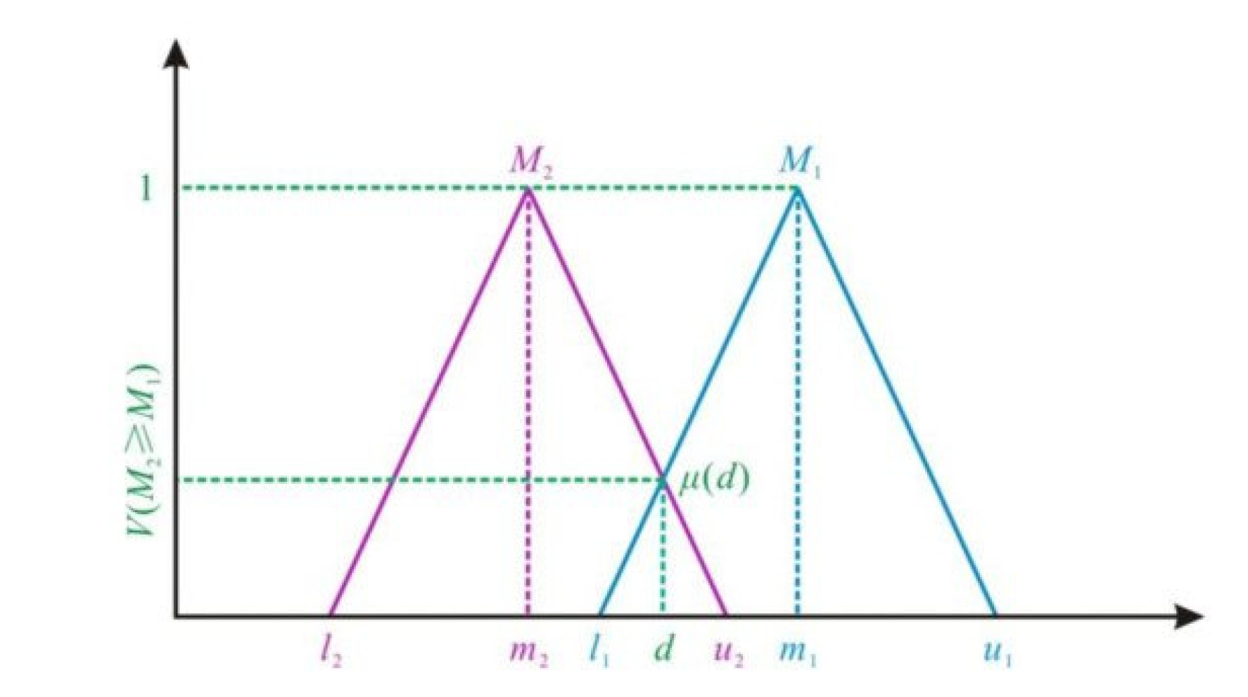
Then we define the degree of possibility in the fuzzy set (Figure 2). The possibility is obtained for each pair-wise comparison and is described as follows:
V M 2 M 1 = 1   i f   m 2 > m 1 0   i f   l 1 > u 2 l 2 u 1 m 1 u 1 m 2 l 2   o t h e r w i s e
  • Step 3a (For original AHP): Validation of the prioritized level
The matrix B and B1 could be acceptable for comparison between criteria, whereas the consistency ratio ( C R ) is less than 0.1, as recommended by Saaty for the AHP technique.
C R = C I R I
  • C R is the Consistency Ratio
  • R I is the Random Index and has already been provided by Saaty (1988) [62], as shown in Table 2 below.
C I is the Consistency Index (CI) and is obtained by calculating:
C I = λ m a x n n 1
λ m a x = j = 1 n w i A i j w i n
  • Step 3b (For the FAHP): Validation of the prioritized level
For the FAHP, the consistency ratio includes both consistency ratio of the middle values TFNs, called C R m , and the consistency ratio of the upper and lower bounds of TFNs, called C R g .
From the matrix (A1), we obtain two matrices as follows. The first matrix was created by the middle numbers of the triangular fuzzy matrix:
C m = m 11 m 12 m 1 i m 1 j m 1 n m 21 m 22 m 2 i m 2 j m 2 n m i 1 m i 2 m i i m i j m i n m j 1 m j 2 m j i m j j m j n m n 1 m n 2 m n i m n j m n n
The second matrix can be created from the geometric mean of the upper and lower bounds of the triangular fuzzy matrix, that is:
C g = l 11 u 11 l 12 u 12 l 1 i u 1 i l 1 j u 1 j l 1 n u 1 n l 21 u 21 l 22 u 22 l 2 i u 2 i l 2 j u 2 j l 2 n u 2 n l i 1 u i 1 l i 2 u i 2 l i i u i i l i j u i j l i n u i n l j 1 u j 1 l j 2 u j 2 l j i u j i l i j u j j l j n u j n l n 1 u n 1 l n 2 u n 2 l n i u n i l n j u n j l n n u n n
To calculate the eigivenvalues:
λ m a x m = j = 1 n w i m i j w i n
and
λ m a x g = j = 1 n w i l i j u i j w i n
Calculate the C R m and C R g based on the Saaty suggestion as in Equations (13) and (14).
  • Step 4 (For both AHP and FAHP): Scoring for attributes of each criterion
This step is based on the knowledge and experiences of each participant; they will score the attributes of each criterion independently based on its suitability. The scoring scale used in the focus group discussion consisted of four levels; highly suitable, moderately suitable, poorly appropriate, and not suitable, as shown in Table 3. The final score of the attributes for each criterion is the geometric mean score of all participants in the discussion. This score will be used for both AHP and FAHP methods. The score of the suitable class for each land unit will be calculated as follows:
S = i = 1 n W i X i a
where S a is the score of land map unit a ; W i is the weight of criterion i ; X i a is the score of the attributes of criteria i for the land map unit a and n is the number of criteria. The suitable class also ranks as Table 3 as recommended by FAO [4] and many previous pieces of research in Vietnam[9,63,64].

2.2.4. Accuracy Assessment

We selected 39 random plots at the research site to validate the result of the land evaluation of both methods. They were collected based on questionnaires for farmers who harvested acacia in 2019 and 2020. The age of acacia trees at harvest is 4.5 years, of which the minimum is four years, and the maximum is six years. The observed data are shown in Table 4.
The accuracy of the AHP and Fuzzy AHP methods has been tested as a linear regression of observed yield and each method’s land suitability score. The coefficient of determination ( R 2 ) of each method will be calculated based on Equation (21), and they will provide information on the success of each method [65]. The value of R 2 ranges from zero (0) to one (1), in which an R 2 of 1 indicates that the regression predictions perfectly fit the data. In this research, the method which has an R2 value higher than that of the remaining method shows that the accuracy of the higher-value method is better.
R 2 = 1 i = 1 n y i y ^ i 2 i = 1 n y ^ i y ¯ 2
where: y i is the observed yield of the plot i t h ; y ^ i is the predicted yield of the plot i t h ; y ¯ is the average of all observed yield plots; n is the number of observed plots.
Another technique has also been used to compare the accuracy of both methods. It is called Root Mean Square Error ( R M S E ) . This index is a frequently used measure of the differences between values predicted by a model and the observed values. It is calculated as Equation (22).
R M S E = 1 n i = 1 n y i y ^ i 2 2
where: y i is the observed yield of the plot i t h ; y ^ i is the predicted yield of the plot i t h ; n is the number of observed plots.
In this research, two methods have been evaluated. Therefore, there are two R M S E values. The method that shows a smaller R M S E indicates that it is the most accurate. Moreover, to assess the percentage of accuracy ( A c c % ) the following Equation (23) has been applied.
A c c % = R M S E S m a l l e r R M S E L a r g e r R M S E S m a l l e r 100

3. Results

3.1. The Selection of Criteria

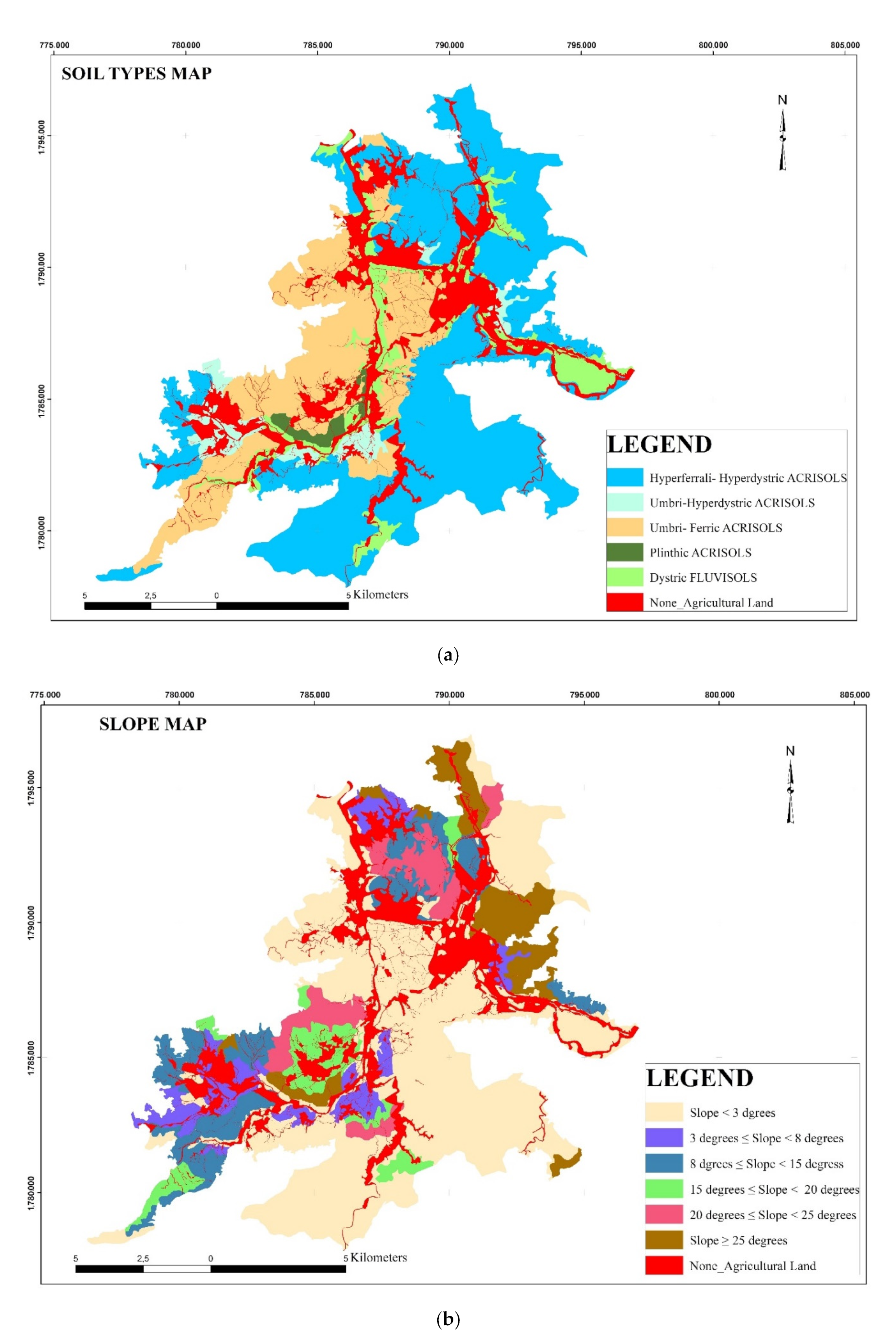
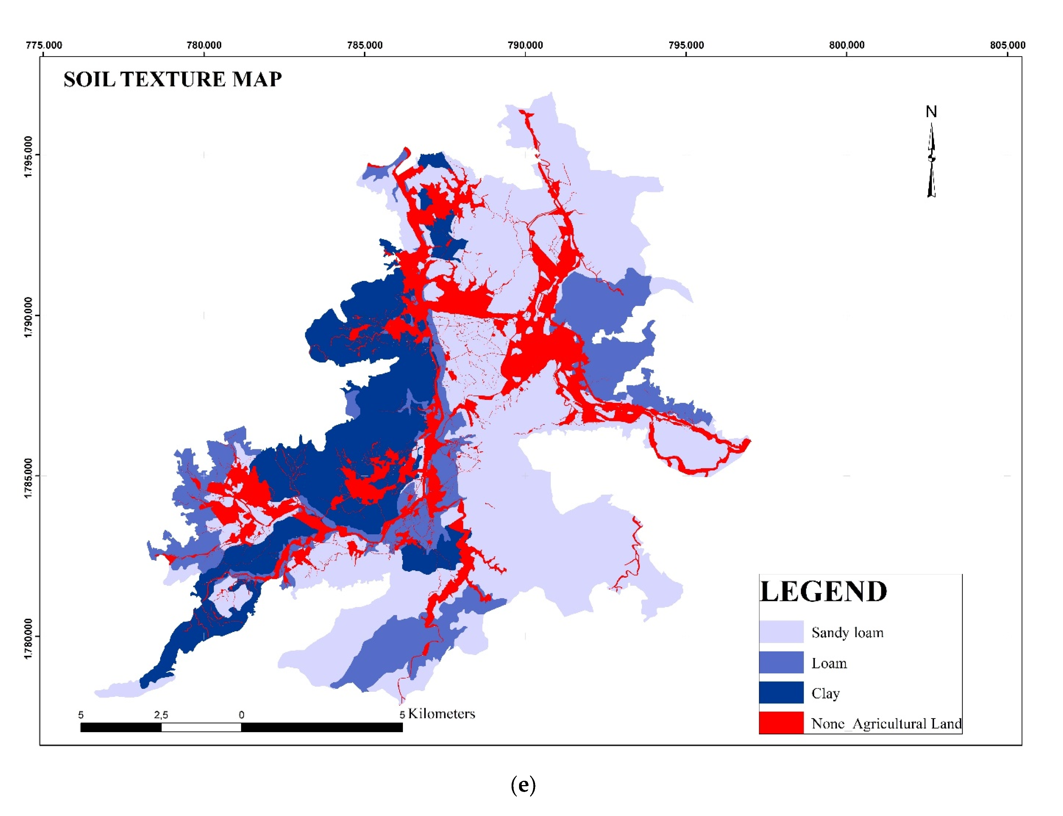
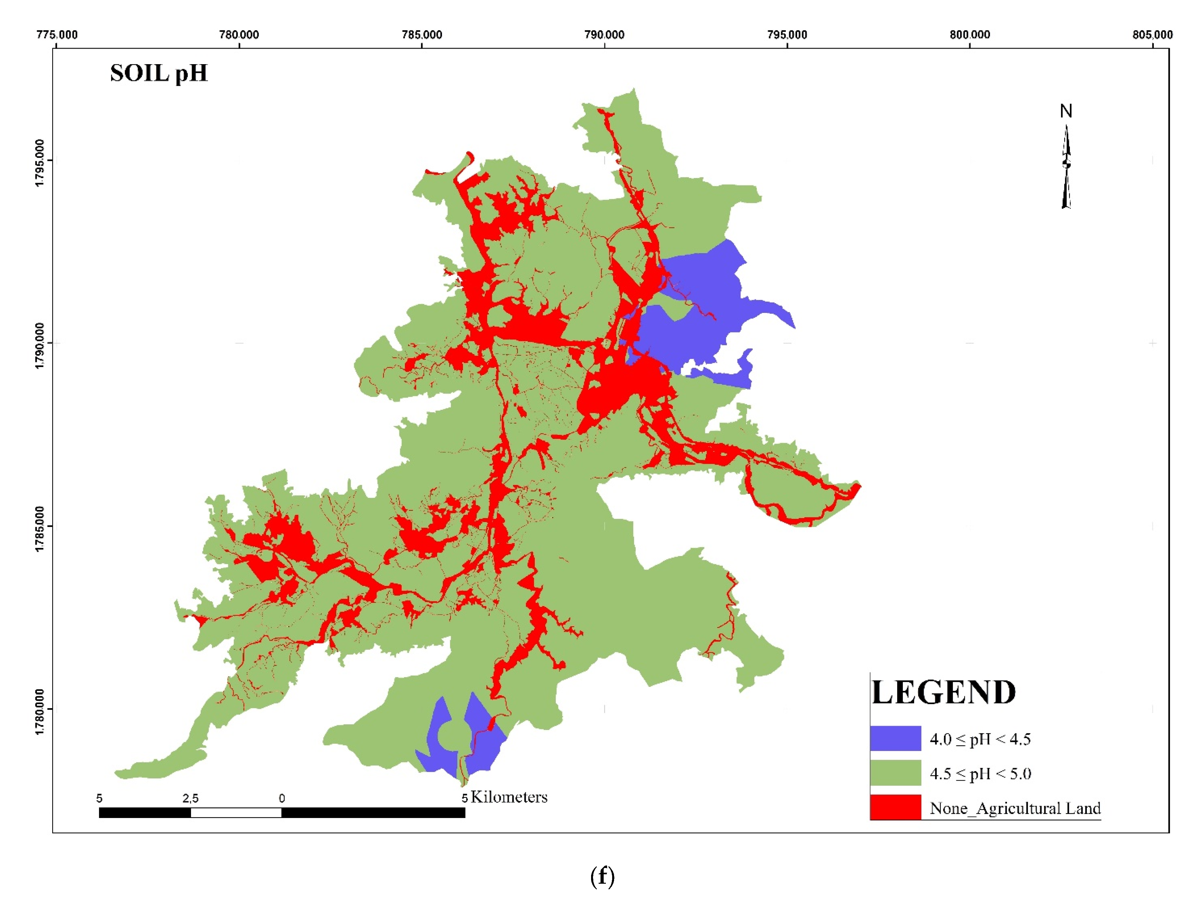
The maps of the six criteria are shown in Figure 3a–d,f,g. The attributes and scores for the land suitability classes of these six criteria are shown in Table 5.
-
Soil types: The Acrisols group is the dominant soil type at the research site and accounts for 89% total area of 12,242 hectares. Which, Hyperferrali- Hyperdystric Acrisols occupied more than half of the total area. The remaining soil type is Dystric Fluvisols which is present predominantly along the rivers/stream systems in the area. At present, the dominant land use type of this soil type is for rice paddies and vegetables.
-
Soil depths: The soil depth is an important factor that affects the development of acacia trees in mountainous regions. However, the soil depth layer is less than 30 cm for around 50% of the total area at the research site and negatively affects the acacia plantations in these regions. The areas where the soil depth is more than 70 cm are concentrated in the central areas of the research site.
-
Soil textures: Sandy-loam is the major soil texture at the research site and covers 60% of the total area. The sandy-loam soil is distributed mainly in the eastern parts of the research site, while clay soil is located in the western parts. The remaining area is comprised of loam soil texture.
-
Slope: The terrain of this research site is quite complicated, and as such, it was divided into six sections. The areas with a slope of less than 30 occupied 58% of the total areas with 7844 hectares. This is beneficial for agricultural development, particularly for acacia plantations. On the contrary, the areas with a slope greater than 200 account for 15% of the research site and are distributed in the southwestern and northeastern parts of the site.
-
Soil Organic Carbon: The SOC content of this research site ranges from 0.45% to 1.85% of soil weight. Thus we divided the SOC content into two groups, less than 1% and from 1% to 2%. The SOC ranges of 1% to 2% are dominant in the site and makeup 68% of the total area.
-
Soil pH: Overall, the soil in the total area can be considered to be acidic. The soil pH ranges from 4.0 to 5.0. Within this range, soil with a pH value between 4.5 and 5.0 occupies 92% of the total area.

3.2. Weighting and Ranking of Criteria

The weighting of each criterion by AHP and FAHP is shown in Table 6, Table 7 and Table 8. These results indicated no difference in the ranking of the criteria on the physical attributes of the land for the acacia plantations. Of these criteria, the soil depth and the topography slope have the most significant weighting compared to other criteria. Following soil depth and slope are SOC, soil texture, soil pH, and soil types, respectively. However, there is a difference in the weight of each criterion, in which the weighted difference amplitude of the criteria performed by the FAHP method is higher than that of the AHP method. This difference can be seen clearly in Figure 4.

3.3. Land Suitability Mapping for Acacia

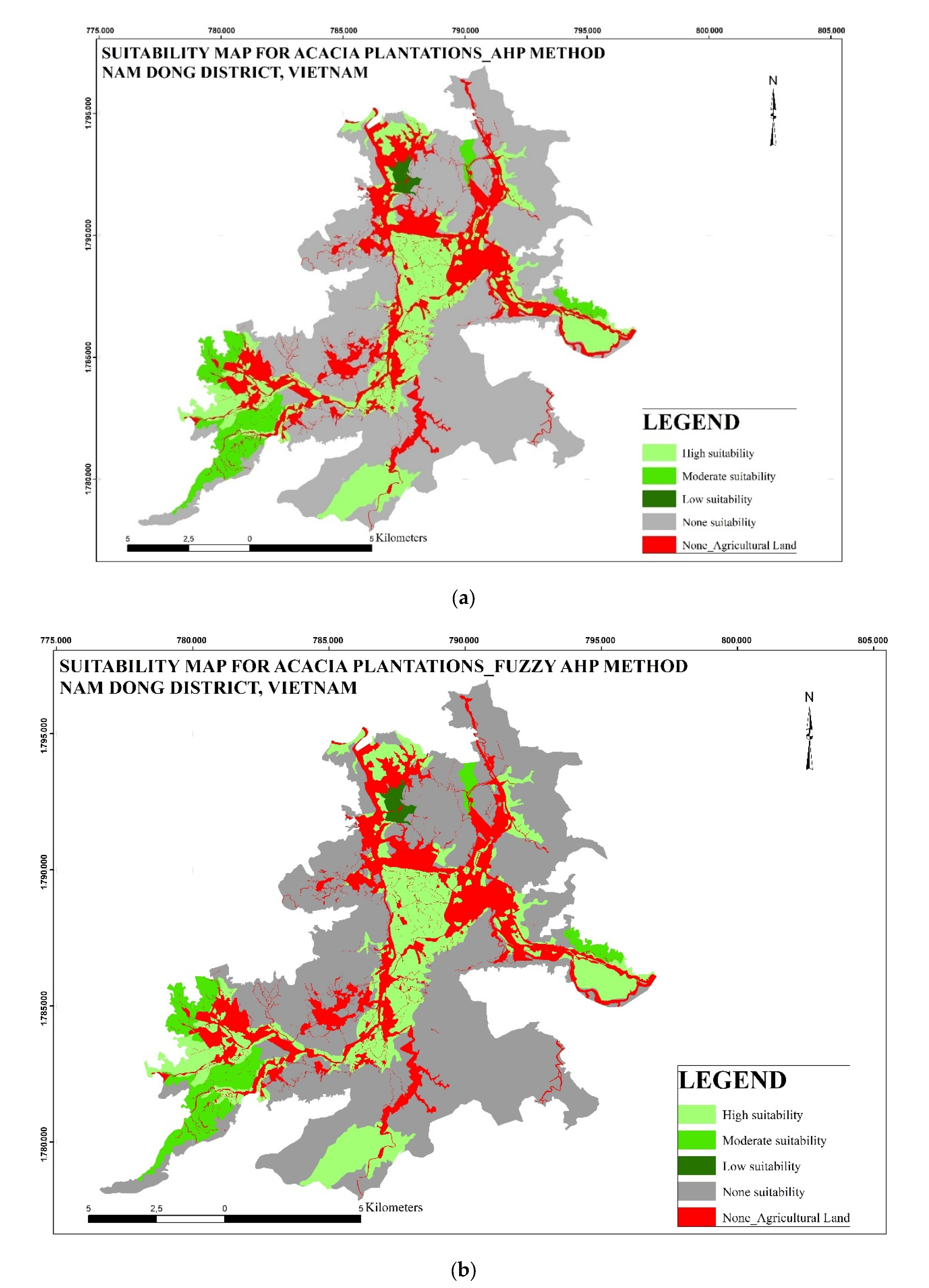
The suitability map for the acacia plantations in Nam Dong district, created by the AHP and FAHP methods, is shown in Figure 5a,b. The areas with no suitability for acacia plantation for both methods are the same and occupy 9769 hectares. The limitation of slope (over 25°) and soil depth (less than 50 cm) are influences that make acacia plantations unsuitable in these areas. The low suitability class accounts for 116 hectares, distributed in the northwestern part of the research site. For the AHP approach, 928 hectares are in the moderate suitability and 3080 hectares in the high suitability. In comparison, 905 hectares of the moderate suitability class and 3102 hectares of the high suitability class were found by the FAHP method. The range of final scores of the FAHP method is more comprehensive than AHP, with minimum and maximum scores of 3.14 and 8.23, compared to 3.61 and 8.12, respectively.
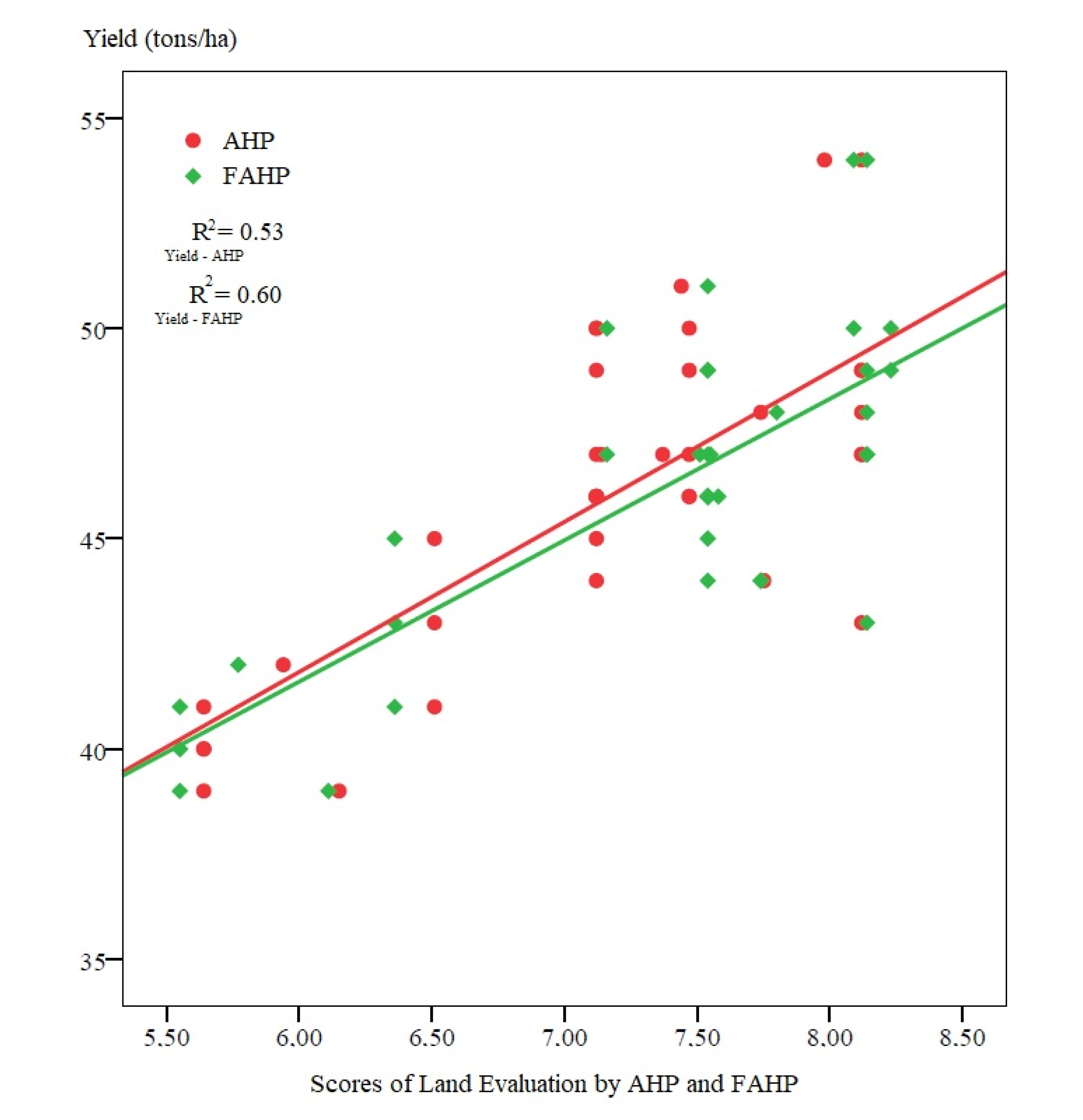
Our investigation showed that indices obtained from the FAHP method correlated more with the observed yield than that of the AHP method, with a coefficient of determination of 0.53 and 0.60, respectively (Figure 6). The R M S E A H P value is 2.49, and the R M S E F A H P is 2.38. The R M S E values of both methods indicated that the land evaluation by FAHP is better than AHP. According to Equation (23), the accuracy of FAHP is higher than AHP at 4.62%. The standard deviation of the AHP method is lower than that of the FAHP method, meaning that the scores of FAHP are more spread out.
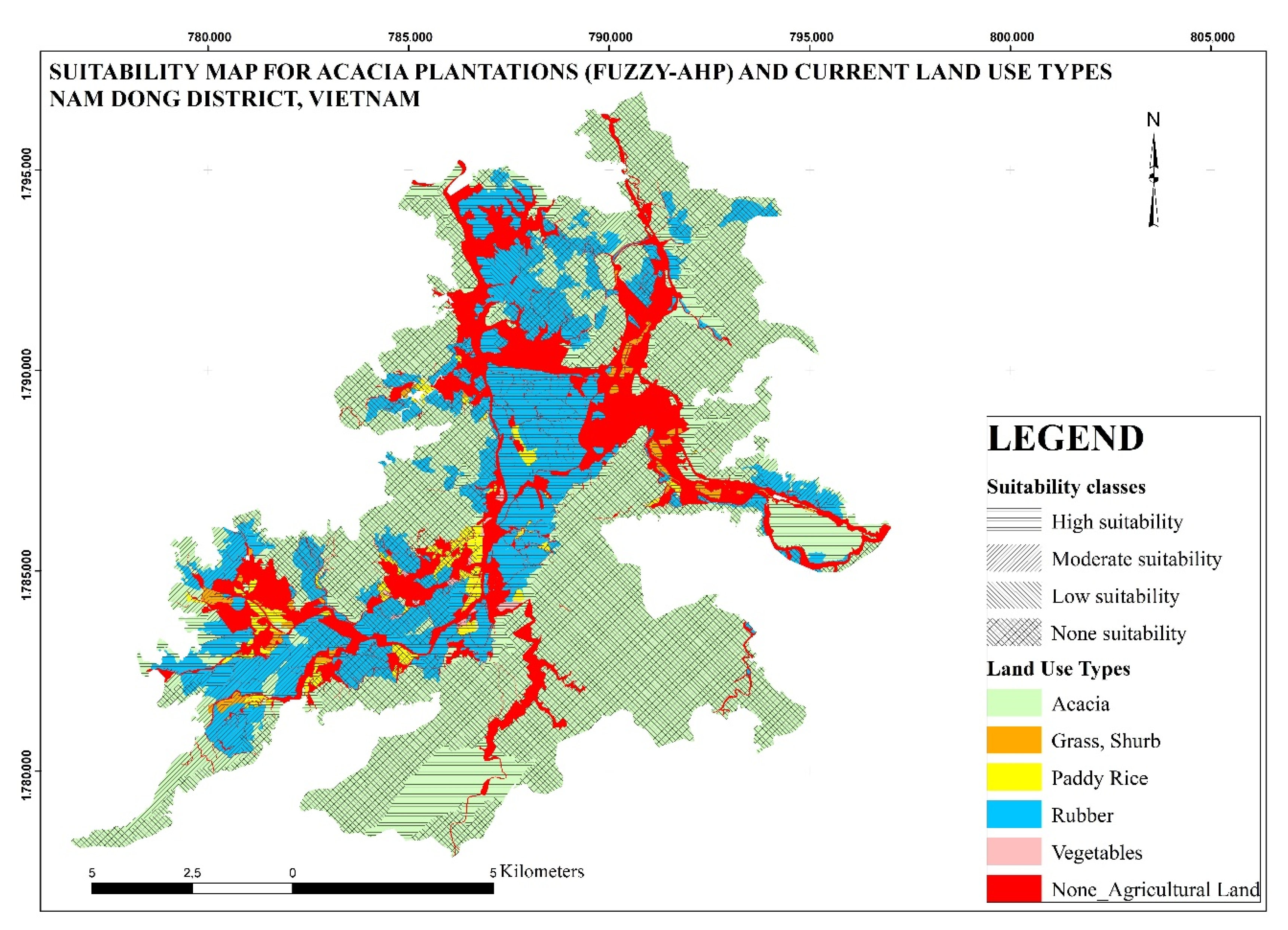
The current land use map for agricultural land purposes has been overlaid with the suitability map of the Fuzzy method to analyze the rationality of land use in Nam Dong district. The result is shown in Table 9 and Figure 7.
The current land use map indicates that acacia and rubber are the main crops in Nam Dong district, accounting for 70% and 26% of this district’s total agricultural land area, corresponding to 9420 ha and 3574 ha, respectively. Among them, the current land area for growing acacia at a highly suitable level is 1277 hectares, at an average suitability level of 392 ha. According to the results of the land assessment, the area that is not suitable for growing acacia but yet has still currently been planted with acacia accounts for 7751 ha. It is worth noting that people often use the area suitable for growing acacia to grow rice and rubber trees.

4. Discussion

Previous research has already established the impact of the physical criteria on the development of acacia in Thua Thien Hue. Ho Thanh Ha (2013) stated that there are significant influences of soil type, soil texture, soil depth, and slope on acacia yield in 36 communes in Thua Thien Hue Province [66]. In our research, soil depth is the most important criterion for acacia plantations. This finding is consistent with research conducted in Indonesia in 1999 [67] which found that soil depth is most strongly correlated to the productivity of acacia among the three variables of soil depth, soil reaction, and horizon depth. As reported in some studies, acacia species have high root density concentrated at a soil depth of 0 cm to 150 cm [68,69]. Therefore, a thick soil layer is a necessary condition for acacia plantation. A recent study in Thua Thien Hue Province showed that 97% of households planted acacia in plots with a slope of less than 300 [35]. This criterion influences most agricultural activities as it affects the rate of soil degradation, especially soil erosion in mountainous regions [70]. The soil texture also influences acacia growth in Vietnam, Tran et al. (2020) [71] stated that there was a negative correlation between the volume of acacia yield and the percentage of loam. A higher number of loam particles leads to more compact soil, which limits root growth because of the difficulty for roots to penetrate, and the limitation of oxygen in the soil. Therefore, the score of sandy loam was highest, followed by loam and clay. Soil type was not an important criterion in the selection process of acacia planting areas; however, the participants agreed that alluvial soil is the most suitable because the soil quality of this kind of soil is better than other soils in Nam Dong. Our research is consistent with other researchers who found that the acacia yield in areas with fluvisols soil is the highest compared to other soils in Thua Thien Hue Province [66]. The soil pH has the lowest influence on acacia plantations. In this research area, the soil pH values range from 4.3 to 5.0, meaning that the soil is very acidic. In Vietnam, soil pH under acacia plantations is generally lower than other land-use types such as pasture, abandoned, and secondary forests [72,73]. Land users and agricultural agencies in Vietnam do not pay much attention to soil acidity in the process of acacia plantations. In the technical manuals for acacia cultivation published by the Ministry of Agriculture of Vietnam, there is no mention of soil acidity analysis, nor do they recommend solutions to reduce acidity for acacia plantations [74]. Growing acacia can cause soil acidity, which has become increasingly common in recent years [75]. Especially for the weathered soil in the wet tropics, acacia plantations are shown to be a cause of soil acidification due to the cations in the soil that are translocated into the biomass of the acacia [76]. Concerning SOC content, Trieu et al. (2016) [73] found that the SOC content of acacia plantations ranges from 1.1% to 3.9%, with SOC in the northern and southern parts of Vietnam being higher than in the Central region. Our research found that the SOC content in Nam Dong district is lower than 2% of soil weight which concurs with other recent studies concerning this area [77,78]. In addition to endemism due to the nature of the soil type, farming practices can also cause low SOC levels, especially in acacia-growing areas. According to a previous study, burning the accumulated litter of vegetation surface from the previous year’s cultivation is a common technique in preparing land for acacia plantations in Thua Thien Hue. This practice also causes a reduction in SOC content [79]. It has also been noted that the cultivation of acacia, if conducted correctly, will increase the amount of SOC significantly, especially the hybrid acacia species [79]. In addition, recent research found that the soil organic matter in coarse soil within the fifth year of the second rotation of acacia plantations is significantly higher than in the seventh year of the first rotation and the second year of the second rotation [80]. The land evaluation result by FAHP methods indicated that the soil type is not an important criterion in the decision on the acacia plantations in the Nam Dong district. This finding is consistent with previous research, which found that acacia is grown in a wide range of soil types, especially in Central Vietnam [33]. There is concern about the extent of the criteria used for land evaluation for agricultural purposes, many researchers suggested that climatic conditions need to be considered as evaluated criteria. Acacia planting sites in Vietnam are at 8° to 22° N and have an elevation of 5 to 500 m. The suitable climatic conditions, the precipitation is 1500 to 2500 mm, and annual temperature is from 23° to 28° C [81]. Our research site is small and within suitable climatic conditions for acacia plantations; therefore, in this research, we did not consider these criteria. However, for other regions, the climatic conditions need to be included in the land evaluation process.
This research did make a comparison of the effectiveness of the Fuzzy-set and Boolean approaches. However, further analysis needs to be carried out regarding these aspects. In the early 1990s, significant research indicated that the Fuzzy set approach provided more gradual results than the Boolean approach in land evaluation for land suitability [82,83]. Many studies show that FAHP is more effective than AHP. Additional research is needed to establish the significant factors contributing to these two methods’ differences. [84]. In the AHP approach, uncertainty factors are not mentioned, and the answers are more categorical than in FAHP; therefore, with AHP, the experts who are questioned must have an excellent knowledge of their subject and be proficient as well as careful with their responses [85,86]. In the case of an uncertain or” fuzzy” environment, fuzzy numbers have to be used for the evaluation due to the deviations of decision-makers [86,87]. Another study that corroborates our findings between the two modalities is Rodcha et al. (2021) [18], which stated that the FAHP is better than the AHP method in land evaluation for cash crops such as eucalyptus in Thailand with an overall accuracy of 80% compared to 71%. The FAHP provides better land evaluation results than the AHP method because the fuzzy scale does not use integer values, and it is more flexible than the AHP scale because it has small fractions between 0–1.
Based on the coefficient of determination between the predicted yield and the observed yield, the hypothesis is further confirmed that the FAHP is more suitable than AHP in land evaluation for acacia plantations in the mountainous regions in Central Vietnam. This suitability may be because there are inconsistencies in the qualifications of fifteen of the participants in our research, a critical factor in these discrepancies being that the members of this group each have different backgrounds and professions. This variable is an inherent weakness of the focus group discussion method. It is unavoidable that the link between people’s perceptions and their socio-cultural situation is critical to decision-making on natural resources [48]. Therefore, it is imperative to find creative and effective ways of reaching a consensus among the various stakeholders in the areas concerned. Recent research indicated that the homogeneity of participants might help promote discussion and exchange, giving cohesive viewpoints that represent shared context, but it cannot apply to projects that aim to support a broad range of users [88]. The groups that are too diverse may pose a different set of problems leading to difficulty in achieving a satisfactory conclusion to the topic [89]. Therefore, in selecting participants for focus group discussion, homogeneity of background among participants is recommended, while conversely, and at the same time, diverse attitudes within the group are beneficial in covering the more obscure aspects of the given subject [90]. The FAHP is more capable of reconciling differences of opinion in the group based on linguistic variables, converted into triangular fuzzy numbers, as compared to the treatment of numerical data such as in the AHP method. Moreover, the variation in opinions will have less impact on the final result due to the lower bound created by TFNs. These findings were also corroborated by Rodcha et al. (2019) [18], who found that in the FAHP model, some factors can be eliminated due to their decreased significance without any effect on the overall results. Thus, individual studies can determine the number of factors to use in the model. In our research, the data from Figure 4 indicates that the weighting of soil pH and soil types by FAHP is less significant than those by AHP. The soil characteristics are continuity and variation factors since the FAHP is a helpful method for land evaluation, especially in agricultural production [91]. The FAHP method can increase the accuracy of land evaluation results by 4.62% in comparison to the original AHP method based on six selected criteria in this research. The characteristics of most of these criteria are clearly expressed as quantitative data; therefore, the differences in the evaluation of participants are not as significant.
A comparison with the current land use map shows that the acacia plantations in Nam Dong district still have shortcomings, as only 1277 hectares out of 3102 hectares of high suitability class are used for acacia. The remaining area is mainly planted with rubber and rice, with an area of 1540 ha and 164 ha, respectively. From 2000–2010, rubber latex prices were very high, and people could harvest all year round, so many households focused on developing rubber plantations in the Nam Dong district [92,93]. The conversion of natural forests to rubber plantations was perpetrated by rubber companies and individual farmers with the encouragement of certain local government bodies [94]. Because rubber prices have decreased in recent years [46], the area of new rubber plantations has not increased. However, due to previous planting practices, local farmers continue to keep these rubber plantations. Recent research indicated that after several rotations of rubber cultivation, the quality of the 0–10 cm soil layer was deficient, with an increase in SOC thermal stability [95]. In addition, the acacia wood market has greatly expanded worldwide to facilitate the demand for furniture production [96]. The contribution of acacia cultivation to household income is increasingly significant [97,98,99]. Therefore, in the future, as the need for rubber plantations continues to decrease in viability, local authorities need to have plans to convert from rubber cultivation to acacia plantations. However, it is necessary to invest in a system of wood factories and logistics to ensure product output for the local farmers. The difficulties due to terrain, poor infrastructure, and the limited number of wood processing companies, the travel time from the villages to the plantations, and the distance from acacia plantations to processing firms continue to be significant limitations for the development of acacia plantations in Nam Dong [46]. In the areas that show non-suitability for acacia cultivation but yet are currently planted with acacia, we found that most of these areas have a thin soil layer. Local farmers planted acacia in these areas with too much density. Farmers tend to harvest these acacia areas in the 4th year instead of waiting until the 7th year when the acacia wood has the most significant biomass and economic value. Wood products in these areas are often of poor quality and, therefore, cannot be processed into valuable furniture but can only be used for export in the form of wood chips. Farmers still grow acacia because they have not had the guidance for cultivating more profitable crops in the long run in these areas. It is possible to implement intercropping with short-term crops such as peanuts, cassava, or lemongrass for these areas. This farming model has been successfully implemented in Thanh Hoi commune in the North of Vietnam [32]. In Thua Thien Hue province, the model of intercropping acacia with cassava has been implemented in some districts, such as A Luoi (2%), Phu Loc (16%), and Huong Tra (20% of total areas). Cassava is often intermixed with newly planted acacia seedlings during the first year after tree harvesting [35].
Acacia plantation is the most viable means of a prosperous livelihood for farmers within the mountainous regions of Central Vietnam. The reasons are that it is highly suitable for the local topographical conditions, its high yield over a short period, and the low cost of start-up [33,46]. In Nam Dong, acacia cultivation accounts for over one-fourth of the revenue for farmers, contributing 1451 USD to an average household farm income of 4415 USD. This income from acacia plantations is higher than other forest and agricultural cultivation in the area and thus creates a positive correlation to the farm scale [46]. Moreover, acacia plantations can improve many aspects of the bio-physical environment, especially by preventing soil erosion and improving soil fertility through nitrogen fixation [95]. In addition, in Vietnam, there are programs combining acacia and beekeeping. According to a report by JICA, with a scale of about 1200 hectares in a commune in the North of Vietnam, there were 82 beekeepers interspersed within existing acacia plantations and produced an amount of honey totaling 3198 L [100]. In Thua Thien Hue province, due to the weather characteristics, it often rains a lot from September to November every year, so it is necessary to consider moving bee colonies to acacia plantations at a suitable time. Because of these factors, land users and decision-making should establish future mandates to expand the areas of acacia plantations. This can be conducted by implementing the re-grouping of lands and land use policies.

5. Conclusions

In this study, six physical soil characteristics of agricultural land areas were selected for land evaluation for acacia plantations in Nam Dong district, Thua Thien Hue Province, central Vietnam, using the AHP and FAHP methods. The ranking of criteria in both methods is the same, but the weighting of each criterion is different. Using the FAHP method, we found that soil depth has the highest priority, with a value of 0.32, but using the AHP method, even though soil depth still has the highest priority, the value is 0.28. Overall, soil depth and slope play an essential role in acacia plantations, followed by SOC, soil texture, soil pH, and the various soil types. This finding indicates that land users need to consider investing in SOC enrichment and also in reducing soil acidity to enhance the effectiveness of acacia plantations at the research site.
The land suitability map was performed by integrating MCDA and GIS technology, showing four suitability classes for acacia plantations in the Nam Dong district. The most suitable areas for growing acacia are concentrated in the valleys, where the soil layer is more than 70 cm thick and the slope is less than 15 degrees. This map is the result of land evaluation based on six physical soil characteristics, and therefore it would be a valuable reference document for agricultural land use planning. For other purposes, e.g., regional master planning or economic development projects, integration with other databases or expansion to other land use criteria are required.
The FAHP method is a practical and suitable approach for land evaluation, especially for agricultural land. This method has advantages and flexibility in converting qualitative to quantitative opinions based on the upper and lower bounds of the triangle of fuzzy numbers. As land evaluation is a complex process involving the participation of many stakeholders, including local government, agricultural scientists, farmers, and other partners in the agricultural value chain, we suggest that FAHP should be used for land evaluation, together with additional social and economic criteria, and also in consideration with other kinds of crop plantations within Vietnam. This combination is more meaningful in the context of sustainable land use in mountainous regions where appropriate agricultural land use is essential in improving the livelihoods of ethnic minority groups and mitigating systemic poverty.
The limitation of this research was that only physical soil criteria for land evaluation were considered, while there are additional criteria that should be considered to have a more comprehensive understanding in regard to the effectiveness of land use in these areas. While the criteria focused on for this study are valuable and relevant in their own right, in regard to future studies, it would be of additional value to include socio-economic factors within the criteria in order to provide a complete land use scenario to serve specific local demands. In addition, it is beneficial to compare the current hierarchical analysis methods with some other contemporary techniques in agricultural land assessment, especially the modern machine learning-based approach.

Author Contributions

Conceptualization, C.T.M.T. and T.G.P.; methodology, T.G.P. and C.T.M.T., Q.N.P.L., H.T.N., N.B.N. and H.D.L.; software, T.G.P. and C.T.M.T.; validation, T.G.P. and C.T.M.T.; formal analysis, H.D.L., T.T.T., H.N.T. and N.B.N.; investigation, T.G.P.; C.T.M.T. and Q.N.P.L.; resources, T.G.P. and C.T.M.T.; data curation, T.G.P.; writing—original draft preparation, T.G.P. and C.T.M.T.; writing—review and editing, T.G.P. and C.T.M.T.; visualization, T.G.P. and H.K.N.N.; project administration, T.G.P. and C.T.M.T.; funding acquisition, T.G.P. and C.T.M.T. All authors have read and agreed to the published version of the manuscript.

Funding

This research was funded by Hue University, grant number DHH-2020-02-138.

Institutional Review Board Statement

Not applicable.

Informed Consent Statement

Not applicable.

Data Availability Statement

Not applicable.

Acknowledgments

The authors thank Hue University for their financial support via grant number DHH-2020-02-138.

Conflicts of Interest

The authors declare no conflict of interest.

References

  1. Jahanshiri, E.; Mohd Nizar, N.M.; Tengku Mohd Suhairi, T.A.S.; Gregory, P.J.; Mohamed, A.S.; Wimalasiri, E.M.; Azam-Ali, S.N. A Land Evaluation Framework for Agricultural Diversification. Sustainability 2020, 12, 3110. [Google Scholar] [CrossRef] [Green Version]
  2. Elsheikh, R.; Mohamed Shariff, A.R.B.; Amiri, F.; Ahmad, N.B.; Balasundram, S.K.; Soom, M.A.M. Agriculture Land Suitability Evaluator (ALSE): A decision and planning support tool for tropical and subtropical crops. Comput. Electron. Agric. 2013, 93, 98–110. [Google Scholar] [CrossRef] [Green Version]
  3. Sonneveld, M.P.W.; Hack-ten Broeke, M.J.D.; van Diepen, C.A.; Boogaard, H.L. Thirty years of systematic land evaluation in the Netherlands. Geoderma 2010, 156, 84–92. [Google Scholar] [CrossRef]
  4. FAO. A Framework for Land Evaluation; Food and Agriculture Organization of The United Nations: Rome, Italy, 1977. [Google Scholar]
  5. AL-Taani, A.; Al-husban, Y.; Farhan, I. Land suitability evaluation for agricultural use using GIS and remote sensing techniques: The case study of Ma’an Governorate, Jordan. Egypt. J. Remote Sens. Sp. Sci. 2021, 24, 109–117. [Google Scholar] [CrossRef]
  6. Barry Dalal, C.; David, D. Surveys, Plans and People: A Review of Land Resource Information and Its Use in Developing Countries; IIED: London, UK, 1993. [Google Scholar]
  7. Everest, T.; Sungur, A.; Özcan, H. Applying the Best–Worst Method for land evaluation: A case study for paddy cultivation in northwest Turkey. Int. J. Environ. Sci. Technol. 2022, 19, 3233–3246. [Google Scholar] [CrossRef]
  8. Elaalem, M.; Comber, A.; Fisher, P. A Comparison of Fuzzy AHP and Ideal Point Methods for Evaluating Land Suitability. Trans. GIS 2011, 15, 329–346. [Google Scholar] [CrossRef]
  9. Herzberg, R.; Pham, T.G.; Kappas, M.; Wyss, D.; Tran, C.T.M. Multi-Criteria Decision Analysis for the Land Evaluation of Potential Agricultural Land Use Types in a Hilly Area of Central Vietnam. Land 2019, 8, 90. [Google Scholar] [CrossRef] [Green Version]
  10. Canco, I.; Kruja, D.; Iancu, T. AHP, a Reliable Method for Quality Decision Making: A Case Study in Business. Sustainability 2021, 13, 13932. [Google Scholar] [CrossRef]
  11. Ordoobadi, S.M. Development of a supplier selection model using fuzzy logic. Supply Chain Manag. Int. J. 2009, 14, 314–327. [Google Scholar] [CrossRef]
  12. Nakandala, D.; Samaranayake, P.; Lau, H.C.W. A fuzzy-based decision support model for monitoring on-time delivery performance: A textile industry case study. Eur. J. Oper. Res. 2013, 225, 507–517. [Google Scholar] [CrossRef]
  13. Leal, J.E. AHP-express: A simplified version of the analytical hierarchy process method. MethodsX 2020, 7, 100748. [Google Scholar] [CrossRef]
  14. Ustaoglu, E.; Sisman, S.; Aydınoglu, A.C. Determining agricultural suitable land in peri-urban geography using GIS and Multi Criteria Decision Analysis (MCDA) techniques. Ecol. Model. 2021, 455, 109610. [Google Scholar] [CrossRef]
  15. Zhang, S.; Liu, X.; Wang, X.; Gao, Y.; Yang, Q. Evaluation of coffee ecological adaptability using Fuzzy, AHP, and GIS in Yunnan Province, China. Arab. J. Geosci. 2021, 14, 1366. [Google Scholar] [CrossRef]
  16. Günal, H.; Kılıc, O.M.; Ersayın, K.; Khalofah, A.; Alsubeie, M.S. Combination of fuzzy-AHP and GIS techniques in land suitability assessment for wheat (Triticum aestivum) cultivation. Saudi J. Biol. Sci. 2022, 29, 2634–2644. [Google Scholar] [CrossRef]
  17. Demirel, T.; Demirel, N.Ç.; Kahraman, C. Fuzzy Analytic Hierarchy Process and its Application. In Fuzzy Multi-Criteria Decision Making; Springer: Boston, MA, USA, 2008; pp. 53–83. [Google Scholar]
  18. Rodcha, R.; Tripathi, N.K.; Shrestha, R.P. Comparison of Cash Crop Suitability Assessment Using Parametric, AHP, and FAHP Methods. Land 2019, 8, 79. [Google Scholar] [CrossRef] [Green Version]
  19. Papadopoulos, A.; Kalivas, D.; Hatzichristos, T. Decision support system for nitrogen fertilization using fuzzy theory. Comput. Electron. Agric. 2011, 78, 130–139. [Google Scholar] [CrossRef]
  20. Chang, D.-Y. Applications of the extent analysis method on fuzzy AHP. Eur. J. Oper. Res. 1996, 95, 649–655. [Google Scholar] [CrossRef]
  21. Liu, Y.; Eckert, C.M.; Earl, C. A review of fuzzy AHP methods for decision-making with subjective judgements. Expert Syst. Appl. 2020, 161, 113738. [Google Scholar] [CrossRef]
  22. Ghodsypour, S.H.; O’Brien, C. A decision support system for supplier selection using an integrated analytic hierarchy process and linear programming. Int. J. Prod. Econ. 1998, 56–57, 199–212. [Google Scholar] [CrossRef]
  23. Peng, G.; Han, L.; Liu, Z.; Guo, Y.; Yan, J.; Jia, X. An Application of Fuzzy Analytic Hierarchy Process in Risk Evaluation Model. Front. Psychol. 2021, 12, 715003. [Google Scholar] [CrossRef]
  24. Xianjin, H.; Huan, L.; Jinliao, H.; Yueguang, Z. Application of GIS-Based Models for Land-Use Planning in China. In Comprehensive Geographic Information Systems; Elsevier: Amsterdam, The Netherlands, 2018; pp. 424–445. [Google Scholar]
  25. Liu, Y.-S.; Wang, J.-Y.; Guo, L.-Y. GIS-Based Assessment of Land Suitability for Optimal Allocation in the Qinling Mountains, China. Pedosphere 2006, 16, 579–586. [Google Scholar] [CrossRef]
  26. Kollias, V.J.; Kalivas, D.P. Land evaluation methodology and GIS for soil resource management. Example with cotton crop in Greece. Agronomie 1999, 19, 107–118. [Google Scholar] [CrossRef] [Green Version]
  27. Nguyen, T.T.; Verdoodt, A.; Van, Y.T.; Delbecque, N.; Tran, T.C.; Van Ranst, E. Design of a GIS and multi-criteria based land evaluation procedure for sustainable land-use planning at the regional level. Agric. Ecosyst. Environ. 2015, 200, 15. [Google Scholar] [CrossRef]
  28. Kazemi, H.; Sadeghi, S.; Akinci, H. Developing a land evaluation model for faba bean cultivation using geographic information system and multi-criteria analysis (A case study: Gonbad-Kavous region, Iran). Ecol. Indic. 2016, 63, 37–47. [Google Scholar] [CrossRef]
  29. Maleki, F.; Kazemi, H.; Siahmarguee, A.; Kamkar, B. Development of a land use suitability model for saffron (Crocus sativus L.) cultivation by multi-criteria evaluation and spatial analysis. Ecol. Eng. 2017, 106, 140–153. [Google Scholar] [CrossRef]
  30. Ostovari, Y.; Honarbakhsh, A.; Sangoony, H.; Zolfaghari, F.; Maleki, K.; Ingram, B. GIS and multi-criteria decision-making analysis assessment of land suitability for rapeseed farming in calcareous soils of semi-arid regions. Ecol. Indic. 2019, 103, 479–487. [Google Scholar] [CrossRef]
  31. Pilevar, A.R.; Matinfar, H.R.; Sohrabi, A.; Sarmadian, F. Integrated fuzzy, AHP and GIS techniques for land suitability assessment in semi-arid regions for wheat and maize farming. Ecol. Indic. 2020, 110, 105887. [Google Scholar] [CrossRef]
  32. Yamamotoo, W.; Le, X.T.; Nguyen, H.T.; Nguyen, T.A.; Le, T.S.; Yumiyama, D. Incorporating Indigenous Species in Smallholders’ Acacia Plantations in Thanh Hoi Commune, Tan Lac District, Hoa Binh Province, Vietnam; Report book of JICA Vietnam Office; JICA Vietnam Office: Ha Noi, Vietnam, 2020; Available online: https://www.jica.go.jp/project/vietnam/037/materials/ku57pq00002hisx7-att/acacia_plantation_en.pdf (accessed on 10 October 2022).
  33. Nambiar, E.S.; Harwood, C.E.; Kien, N.D. Acacia plantations in Vietnam: Research and knowledge application to secure a sustainable future. South. For. A J. For. Sci. 2015, 77, 999301. [Google Scholar] [CrossRef]
  34. Griffin, A.R.; Nambiar, E.S.; Harwood, C.E.; See, L.S. Sustaining the future of Acacia plantation forestry–a synopsis. South. For. A J. For. Sci. 2015, 77, v–viii. [Google Scholar] [CrossRef]
  35. Cochard, R.; Vu, B.T.; Ngo, D.T. Acacia Plantation Development and the Configuration of Tree Farmers’ Agricultural Assets and Land Management—A Survey in Central Vietnam. Land 2021, 10, 1304. [Google Scholar] [CrossRef]
  36. Tham, L.T.; Darr, D.; Pretzsch, J. Analysis of Acacia hybrid timber value chains: A case study of woodchip and furniture production in central Vietnam. For. Policy Econ. 2021, 125, 102401. [Google Scholar] [CrossRef]
  37. Jean, P.A.; Bôi, P.T.; Amélie, R.; Tran, H.N. Can fast-growing species form high-quality forests in Vietnam? Examples in Thừa Thiên Huế province. Bois Forets Des Trop. 2010, 305, 67–76. [Google Scholar]
  38. Koutika, L.-S.; Richardson, D.M. Acacia mangium Willd: Benefits and threats associated with its increasing use around the world. For. Ecosyst. 2019, 6, 2. [Google Scholar] [CrossRef] [Green Version]
  39. Elfiati, D.; Siregar, O.S. Land suitability evaluation for forestry plants in Tao Lake, Padang Lawas Utara District, North Sumatra. IOP Conf. Ser. Earth Environ. Sci. 2019, 365, 012011. [Google Scholar] [CrossRef]
  40. Nguyen, C.; Mues, V.; Michael, K. Facilitating objective forest land use decisions by site classification and tree growth modeling: A case study from Vietnam. IFOREST Biogeosci. For. 2019, 12, 542–550. [Google Scholar] [CrossRef]
  41. Nam Dong District People’s Committee. Land Use Planning Project of Nam Dong District in 2020; Nam Dong District People’s Committee: Thua Thien Hue, Vietnam, 2020. [Google Scholar]
  42. Kunert, N.; Cárdenas, A. Are Mixed Tropical Tree Plantations More Resistant to Drought than Monocultures? Forests 2015, 6, 2029–2046. [Google Scholar] [CrossRef] [Green Version]
  43. Bui, L.K.; Awange, J.; Vu, D.T. Precipitation and Soil Moisture Spatio-Temporal Variability and Extremes over Vietnam (1981–2019): Understanding Their Links to Rice Yield. Sensors 2022, 22, 1906. [Google Scholar] [CrossRef]
  44. Food and Agriculture Organization. World Reference Base for Soil Resources 2014. International Soil Classification System for Naming Soils and Creating Legends for Soil Maps; Peter, S., Cornie, H., Erika, M., Eds.; Update 201; FAO: Rome, Italy, 2015; ISBN 978-92-5-108369-7. [Google Scholar]
  45. Nam Dong District People’s Committee. Annual Reports of Nam Dong District, Thua Thien Hue Province in 2020; Nam Dong District People’s Committee: Thua Thien Hue, Vietnam, 2020. [Google Scholar]
  46. Tham, L.T.; Darr, D.; Pretzsch, J. Contribution of Small-Scale Acacia Hybrid Timber Production and Commercialization for Livelihood Development in Central Vietnam. Forests 2020, 11, 1335. [Google Scholar] [CrossRef]
  47. Ossadnik, W.; Schinke, S.; Kaspar, R.H. Group Aggregation Techniques for Analytic Hierarchy Process and Analytic Network Process: A Comparative Analysis. Group Decis. Negot. 2016, 25, 421–457. [Google Scholar] [CrossRef] [Green Version]
  48. Nyumba, T.; Wilson, K.; Derrick, C.J.; Mukherjee, N. The use of focus group discussion methodology: Insights from two decades of application in conservation. Methods Ecol. Evol. 2018, 9, 20–32. [Google Scholar] [CrossRef] [Green Version]
  49. Berkes, F. Rethinking Community-Based Conservation. Conserv. Biol. 2004, 18, 621–630. [Google Scholar] [CrossRef]
  50. National Institute of Agricultural Planning and Projection. Soil Map of Thua Thien Hue Province; National Institute of Agricultural Planning and Projection: Hanoi, Vietnam, 2005. [Google Scholar]
  51. Walkley, A.; Black, I.A. An Examination of The Degtjareff Method for Determining Soil Organic Matter, and a Proposed Modification of the Chromic Acid Titration Method. Soil Sci. 1934, 37, 29–38. [Google Scholar] [CrossRef]
  52. Food and Agriculture Organization. Guidelines for Soil Description; Food and Agriculture Organization: Rome, Italy, 2006; ISBN 9251055211. [Google Scholar]
  53. Bhunia, G.S.; Shit, P.K.; Maiti, R. Comparison of GIS-based interpolation methods for spatial distribution of soil organic carbon (SOC). J. Saudi Soc. Agric. Sci. 2018, 17, 114–126. [Google Scholar] [CrossRef] [Green Version]
  54. Kabir, G.; Akhtar Hasin, M.A. Comparative analysis of AHP and Fuzzy AHP models for multicriteria inventory classification. Int. J. Fuzzy Log. Syst. 2011, 1, 1–16. [Google Scholar]
  55. Perçin, S. Use of fuzzy AHP for evaluating the benefits of information-sharing decisions in a supply chain. J. Enterp. Inf. Manag. 2008, 21, 263–284. [Google Scholar] [CrossRef]
  56. Vinogradova-Zinkevič, I.; Podvezko, V.; Zavadskas, E.K. Comparative Assessment of the Stability of AHP and FAHP Methods. Symmetry 2021, 13, 479. [Google Scholar] [CrossRef]
  57. Leśniak, A.; Kubek, D.; Plebankiewicz, E.; Zima, K.; Belniak, S. Fuzzy AHP Application for Supporting Contractors’ Bidding Decision. Symmetry 2018, 10, 642. [Google Scholar] [CrossRef] [Green Version]
  58. Kim, C.; Kim, Y.; Yi, H. Fuzzy Analytic Hierarchy Process-Based Mobile Robot Path Planning. Electronics 2020, 9, 290. [Google Scholar] [CrossRef] [Green Version]
  59. Wang, G.; Liu, Y.; Hu, Z.; Zhang, G.; Liu, J.; Lyu, Y.; Gu, Y.; Huang, X.; Zhang, Q.; Liu, L. Flood Risk Assessment of Subway Systems in Metropolitan Areas under Land Subsidence Scenario: A Case Study of Beijing. Remote Sens. 2021, 13, 637. [Google Scholar] [CrossRef]
  60. Akıncı, H.; Özalp, A.Y.; Turgut, B. Agricultural land use suitability analysis using GIS and AHP technique. Comput. Electron. Agric. 2013, 97, 71–82. [Google Scholar] [CrossRef]
  61. Everest, T.; Koparan, H.; Sungur, A.; Özcan, H. An important tool against combat climate change: Land suitability assessment for canola (a case study: Çanakkale, NW Turkey). Environ. Dev. Sustain. 2022, 24, 13137–13172. [Google Scholar] [CrossRef]
  62. Saaty, T. Decision making with the analytic hierarchy process. Int. J. Serv. Sci. 2008, 1, 83–98. [Google Scholar] [CrossRef]
  63. Tong, T.H.; Pham, M.P.; Bui, T.Q.; Nguyen, T.M.H.; Nguyen, T.T.N.; Balakirev, A.E.; Lahori, A.H. Land Suitability Modeling For Ricecrop Based On An Integrated Multi-Criteria Decision Making In Quang Tri Province Of Vietnam. Geogr. Environ. Sustain. 2021, 14, 63–72. [Google Scholar] [CrossRef]
  64. Van Chuong, H. Multicriteria Land Suitability Evaluation for Selected Crops in Hilly Region of Central Vietnam; Shaker Verlag: Berlin, Germany, 2007; ISBN 978-3-8322-6846-6. [Google Scholar]
  65. Günal, H.; Orhan, M.K.; Kemal, E.; Nurullah, A. Land suitability assessment for wheat production using analytical hierarchy process in a semi-arid region of Central Anatolia. Geocarto Int. 2022, 37, 2108911. [Google Scholar] [CrossRef]
  66. Ho, T.H. The impact of factors affecting the productivity of Acacia hybrid forest in Thua Thien Hue (Các nhân tố ảnh hưởng đến năng suất rừng keo lai tại tỉnh Thừa Thiên Huế). Vietnam For. 2013, 2, 2728–2738. [Google Scholar]
  67. Hafiziansyah, G. Evaluation of suitability of Acacia mangium and Eucalyptus deglupta in timber estate area at PT Surya Hutani Jaya Sebulu, East Kalimantan. Bul. Budid. Pertan. 1999, 5, 43–51. [Google Scholar]
  68. Nguyen, V.C.; Doan, T.P.L. Summarising report of study “Reseaching growth system of root, trunk, leaves and biomass of the 1st year hybrid black wood in three methods: Transplant of tissue, cutting and seeds” (Báo cáo tóm tắt kết quả " Nghien cứu hệ sinh trưởng rễ, thân, lá và sinh. J. Tan Trao Univ. 2018, 9, 69–72. [Google Scholar]
  69. Germon, A.; Guerrini, I.A.; Bordron, B.; Bouillet, J.-P.; Nouvellon, Y.; de Moraes Gonçalves, J.L.; Jourdan, C.; Paula, R.R.; Laclau, J.-P. Consequences of mixing Acacia mangium and Eucalyptus grandis trees on soil exploration by fine-roots down to a depth of 17 m. Plant Soil 2018, 424, 203–220. [Google Scholar] [CrossRef] [Green Version]
  70. Fu, Z.; Li, Z.; Cai, C.; Shi, Z.; Xu, Q.; Wang, X. Soil thickness effect on hydrological and erosion characteristics under sloping lands: A hydropedological perspective. Geoderma 2011, 167–168, 41–53. [Google Scholar] [CrossRef]
  71. Dung, P.T.; Van Ban, D.; Tuyen, P.Q.; Trung, P.D.; Hoang, N.H.; Thanh, L.Q.; Khuong, N.V.; Van Tuan, N.; Long, T.H.; Tan, B.T.; et al. Soil Texture, Organic Matter and Nutrients Affect Production of Acacia in Northeast Vietnam. Asian J. Adv. Res. Rep. 2020, 12, 33–41. [Google Scholar] [CrossRef]
  72. Hung, T.T.; Doyle, R.; Eyles, A.; Mohammed, C. Comparison of soil properties under tropical Acacia hybrid plantation and shifting cultivation land use in northern Vietnam. South. For. A J. For. Sci. 2017, 79, 9–18. [Google Scholar] [CrossRef]
  73. Hung, T.T.; Almeida, A.C.; Eyles, A.; Mohammed, C. Predicting productivity of Acacia hybrid plantations for a range of climates and soils in Vietnam. For. Ecol. Manag. 2016, 367, 97–111. [Google Scholar] [CrossRef]
  74. Ministry of Agriculture and Rural Development of Vietnam. Issues Technical Guidelines for Large Wood Intensive Forest and Transformation of Small Wood Plant for Large Wood for Acacia Plantation; Ministry of Agriculture and Rural Development of Vietnam: Hanoi, Vietnam, 2019. [Google Scholar]
  75. Nambiar, E.K.S.; Harwood, C.E. Productivity of acacia and eucalypt plantations in Southeast Asia. 1. Bio-physical determinants of production: Opportunities and challenges. Int. For. Rev. 2014, 16, 225–248. [Google Scholar] [CrossRef]
  76. Yamashita, N.; Ohta, S.; Hardjono, A. Soil changes induced by Acacia mangium plantation establishment: Comparison with secondary forest and Imperata cylindrica grassland soils in South Sumatra, Indonesia. For. Ecol. Manag. 2008, 254, 362–370. [Google Scholar] [CrossRef]
  77. Huynh, C.V.; Nguyen, P.T.; Pham, T.G.; Nguyen, H.T.; Nguyen, M.T.H.; Tran, P.T. Evaluation of Soil Organic Matter Content under Topographic Influences in Agroforestry Ecosystems: A Study in Central Vietnam. Eurasian Soil Sci. 2022, 55, 1041–1051. [Google Scholar] [CrossRef]
  78. Van Huynh, C.; Pham, T.G.; Nguyen, L.H.K.; Nguyen, H.T.; Nguyen, P.T.; Le, Q.N.P.; Tran, P.T.; Nguyen, M.T.H.; Tran, T.T.A. Application GIS and remote sensing for soil organic carbon mapping in a farm-scale in the hilly area of central Vietnam. Air Soil Water Res. 2022, 15, 117862212211147. [Google Scholar] [CrossRef]
  79. Dong, T.L.; Doyle, R.; Beadle, C.L.; Corkrey, R.; Quat, N.X. Impact of short-rotation Acacia hybrid plantations on soil properties of degraded lands in Central Vietnam. Soil Res. 2014, 52, 271. [Google Scholar] [CrossRef]
  80. Koutika, L.-S.; Ngoyi, S.; Cafiero, L.; Bevivino, A. Soil organic matter quality along rotations in acacia and eucalypt plantations in the Congolese coastal plains. For. Ecosyst. 2019, 6, 39. [Google Scholar] [CrossRef] [Green Version]
  81. Chau, S.; Ralph, M. Acacia Hybird: Ecology and Silviculture in Vietnam; CIFOR: Bogor Regency, Indonesia, 2011. [Google Scholar]
  82. Burrough, P.A.; Macmillan, R.A.; Deursen, W. Fuzzy classification methods for determining land suitability from soil profile observations and topography. J. Soil Sci. 1992, 43, 193–210. [Google Scholar] [CrossRef]
  83. Davidson, D.A.; Theocharopoulos, S.P.; Bloksma, R.J. A land evaluation project in Greece using GIS and based on Boolean and fuzzy set methodologies. Int. J. Geogr. Inf. Syst. 1994, 8, 369–384. [Google Scholar] [CrossRef]
  84. Mosadeghi, R.; Warnken, J.; Tomlinson, R.; Mirfenderesk, H. Comparison of Fuzzy-AHP and AHP in a spatial multi-criteria decision making model for urban land-use planning. Comput. Environ. Urban Syst. 2015, 49, 54–65. [Google Scholar] [CrossRef] [Green Version]
  85. Mulubrhan, F.; Mokhtar, A.A.; Muhammad, M. Comparative Analysis between Fuzzy and Traditional Analytical Hierarchy Process. MATEC Web Conf. 2014, 13, 01006. [Google Scholar] [CrossRef] [Green Version]
  86. Aliyev, R.; Temizkan, H.; Aliyev, R. Fuzzy Analytic Hierarchy Process-Based Multi-Criteria Decision Making for Universities Ranking. Symmetry 2020, 12, 1351. [Google Scholar] [CrossRef]
  87. Kabir, G.; Akhtar Hasin, M.A. Multiple criteria inventory classification using fuzzy analytic hierarchy process. Int. J. Ind. Eng. Comput. 2012, 3, 123–132. [Google Scholar] [CrossRef]
  88. Lazar, J.; Feng, J.H.; Hochheiser, H. Interviews and Focus Groups. In Research Methods in Human Computer Interaction; Elsevier: Amsterdam, The Netherlands, 2017; pp. 187–228. [Google Scholar]
  89. Richard, A.K.; Mary, A.C. Focus Groups: A Practical Guide for Applied Research, 4th ed.; SAGE Publications, Inc.: New York, NY, USA, 2008; ISBN 978-1412969475. [Google Scholar]
  90. Morgan, D. Focus Groups as Qualitative Research; SAGE Publications, Inc.: New York, NY, USA, 1997; ISBN 9780761903437. [Google Scholar]
  91. Tuğaç, M.G. GIS-Based Land Suitability Classification for Wheat Cultivation Using Fuzzy Set Model. Int. J. Agric. Environ. Food Sci. 2021, 5, 524–536. [Google Scholar] [CrossRef]
  92. Nguyen, T.T.P.; Masuda, M.; Iwanaga, S. The effect of forestland allocation to the livelihoods of local people in the North Central Coast of Vietnam: A case in Nam Dong district. Tropics 2016, 24, 169–180. [Google Scholar] [CrossRef] [Green Version]
  93. Nguyen, D.; Edward, L.W. Incentives of the forest land allocation process: Implication for forest management inNam Dong district, central Vietnam. In Decentralization, Forests and Rural Communities: Policy Outcomes in Southeast Asia First Edition; Edward, L.W., Ganesh, S., Eds.; SAGE Publications, Inc.: New Delhi, India, 2008; pp. 269–291. ISBN 978-0761935483. [Google Scholar]
  94. Phuc, T.; Nghi, T. Rubber Expansion and Forest Protection in Vietnam, 1st ed.; Tropenbos International Viet Nam: Hue, Vietnam, 2014. [Google Scholar]
  95. Worku, T.; Mekonnen, M.; Yitaferu, B.; Cerdà, A. Conversion of crop land use to plantation land use, northwest Ethiopia. Trees For. People 2021, 3, 100044. [Google Scholar] [CrossRef]
  96. Trædal, L.T.; Vedeld, P. Cultivating forests: The role of forest land in household livelihood adaptive strategies in the Bac Kan Province of northern Vietnam. Land Use Policy 2018, 73, 249–258. [Google Scholar] [CrossRef]
  97. Li, R.; Zheng, H.; Zhang, C.; Keeler, B.; Samberg, L.H.; Li, C.; Polasky, S.; Ni, Y.; Ouyang, Z. Rural Household Livelihood and Tree Plantation Dependence in the Central Mountainous Region of Hainan Island, China: Implications for Poverty Alleviation. Forests 2020, 11, 248. [Google Scholar] [CrossRef] [Green Version]
  98. McWhirte, L. Economic Sustainability of Second Rotation Acacia Plantations in Central Vietnam; Southern Cross University: Lismore, Australia, 2016. [Google Scholar]
  99. Van Khuc, Q.; Le, T.-A.T.; Nguyen, T.H.; Nong, D.; Tran, B.Q.; Meyfroidt, P.; Tran, T.; Duong, P.B.; Nguyen, T.T.; Tran, T.; et al. Forest Cover Change, Households’ Livelihoods, Trade-Offs, and Constraints Associated with Plantation Forests in Poor Upland-Rural Landscapes: Evidence from North Central Vietnam. Forests 2020, 11, 548. [Google Scholar] [CrossRef]
  100. Nguyen, T.; Tran, H.; Yamamotoo, W. Creating Sustainable Short-term Income from Beekeeping Promotion in Thanh Hoi Commune, Tan Lac District, Hoa Binh Province, Vietnam; JICA: Hanoi, Viet Nam, 2020. [Google Scholar]
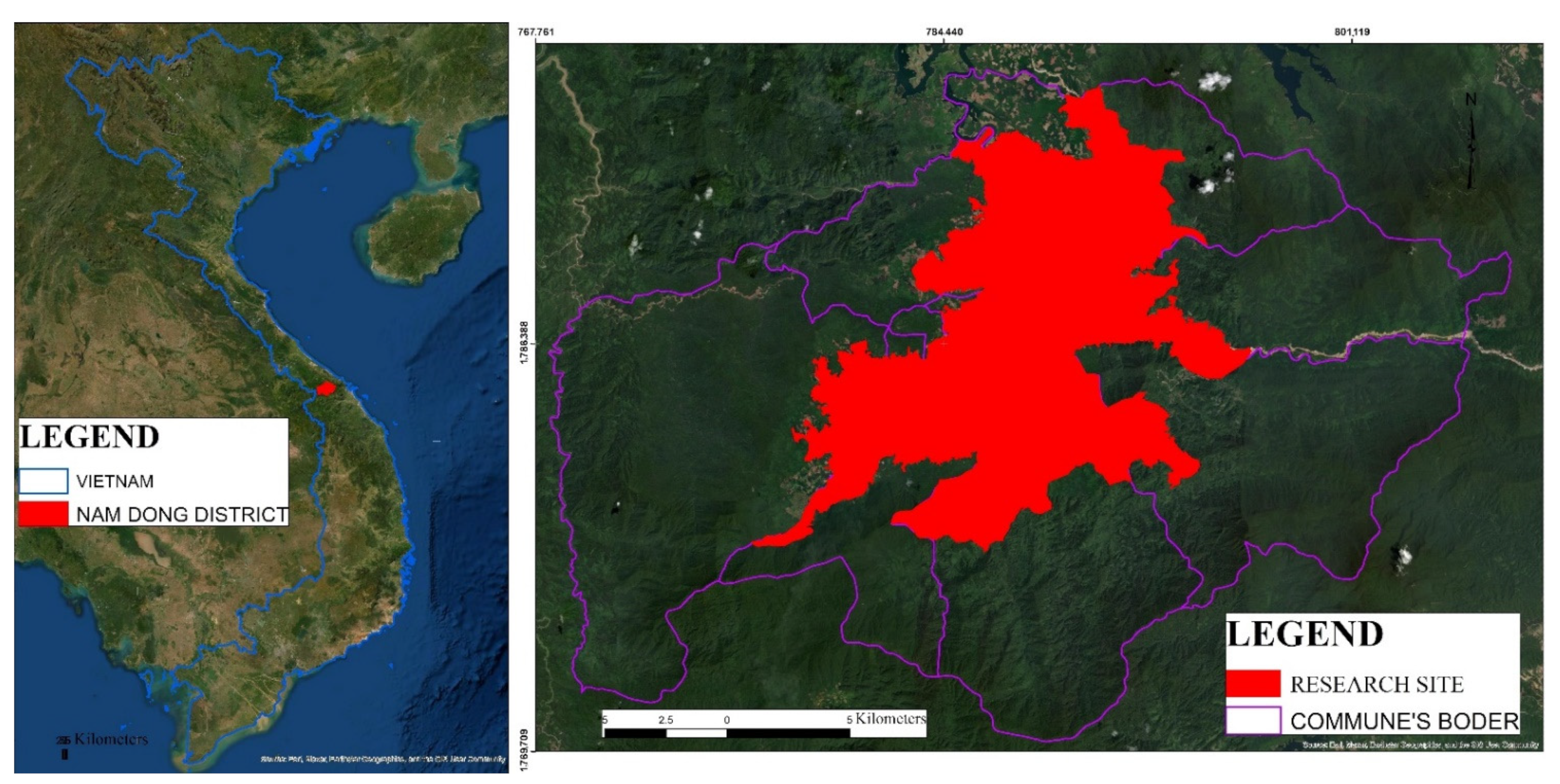
Figure 1. The location of Nam Dong district in Vietnam, including the research site.
Land 11 02184 g001
Figure 2. Possible degree of two triangular fuzzy numbers μ (M2M1) (Cited: Wang et al., 2021 [59]).
Land 11 02184 g002
Figure 3. (a) Soil types map. (b) Slope map. (c) Soil depths map. (d) Soil Organic Carbon map. (e) Soil texture map. (f) Soil pH map.
Land 11 02184 g003aLand 11 02184 g003bLand 11 02184 g003cLand 11 02184 g003d
Figure 4. The differences in criteria weighting by AHP and FAHP.
Land 11 02184 g004
Figure 5. (a) Suitability map for acacia plantation by the AHP method. (b) Suitability map for acacia plantation by FAHP method.
Land 11 02184 g005
Figure 6. Comparison of coefficient of determination of both methods.
Land 11 02184 g006
Figure 7. Suitability map for acacia plantation (FAHP method) and current land use types.
Land 11 02184 g007
Table 1. The scales for pairwise comparison by AHP and FAHP.
AHP Scale FAHP   Scale   ( l , m , u ) Description
9(9,9,9)Criterion   i is extremely more important than criterion j
7(6,7,8)Criterion   i is strongly more important than criterion j
5(4,5,6)Criterion   i is more important than criterion j
3(2,3,4) Criterion   i is slightly more important than criterion j
1(1,1,1)Criteria   i is equally important as criterion j
1/3(1/4,1/3,1/2) Criterion   i is slightly less important than criterion j
1/5(1/6,1/5,1/4)Criterion   i is less important than criterion j
1/7(1/8,1/7,1/6)Criterion   i is strongly less important than criterion j
1/9(1/9,1/9,1/9)Criterion   i is extremely less important than criterion j
2;4;6;8(1,2,3);(3,4,5);(5,6,7),(7,8,9)Used to represent compromise between the priorities listed
The AHP is conducted as in previous research [9,10], and FAHP has been implemented following certain steps as indicated here [57,58,59].
Table 2. Random Index based on the number of criteria.
n12345678910
RI000.580.901.121.241.321.411.451.49
Table 3. Scale for scoring according to MCDA approaches.
Score   ( X i ) DefinitionSuitable Class
7–9Criterion is suitable for acacia plantation without any concerns.Highly suitability
5–7Criterion is suitable for acacia plantation with few concerns.Moderately suitability
3–5Criterion may be suitable for acacia plantation with many concerns.Low suitability
1–3Criterion is unsuitable for acacia plantation.None suitability
Table 4. Descriptive Statistics of selected plots.
VariablesNumberMinimumMaximumMeanStd. Deviation
Scores of AHP395.648.127.180.76
Scores of FAHP395.558.237.320.85
Yield (Tons/ha)3939.054.046.033.70
Table 5. Attributes of each criterion and its score.
CriterionAttributesArea
(Hectares)
Score
(Geometric Mean)
Soil typesHyperferrali- Hyperdystric ACRISOLS78886.5
Umbri-Hyperdystric ACRISOLS5487.5
Umbri- Ferric ACRISOLS36245.8
Plinthic ACRISOLS1846.3
Dystric FLUVISOLS12168.0
Soil depthSoil depth ≥ 100 cm14808.5
70 cm ≤ Soil depth < 100 cm20756.9
50 cm ≤ Soil depth < 70 cm12663.5
30 cm ≤ Soil depth < 50 cm7982.0
Soil depth < 30 cm78411.8
Soil textureSandy—Loam78797.8
Loam26366.2
Clay29465.1
SlopeSlope < 30 78448.7
30 ≤ Slope < 809478.5
80 ≤ Slope < 150 15127.0
150 ≤ Slope < 200 8135.3
200 ≤ Slope < 250 10383.5
Slope ≥ 25013071.0
Soil Organic Carbon1% < SOC ≤ 2%92707.8
SOC ≤ 1%41916.2
Soil pH4.0 ≤ soil pH value < 4.510546.5
4.5 ≤ soil pH value < 5.012,4067.5
Table 6. The pairwise comparison matrix and criteria weight by AHP method.
CriteriaSoil TypesSoil DepthSoil TextureSlopeSOCSoil pHWeightingRank
Soil types0.090.090.100.090.080.100.096
Soil depth0.290.280.240.300.300.260.281
Soil texture0.100.130.110.090.100.120.114
Slope0.260.240.300.260.290.230.262
SOC0.180.150.160.140.150.190.163
Soil pH0.090.110.100.120.080.100.105
λ m a x = 6.03;        C I = 0.03          C R = 0.005 < 0.1
Table 7. The pairwise comparison matrix by FAHP.
CriteriaSoil TypesSoil DepthSoil TextureSlopeSOCSoil pH
Soil types1.001.001.000.230.310.470.630.921.310.260.340.500.380.510.740.641.011.48
Soil depth2.143.224.261.001.001.001.372.193.161.041.361.791.351.952.651.552.213.18
Soil texture0.761.081.600.320.460.731.001.001.000.280.360.510.490.651.000.691.121.70
Slope2.022.983.880.560.740.961.962.773.521.001.001.001.251.892.741.672.273.02
SOC1.351.972.610.380.510.741.001.532.050.360.530.801.001.001.001.461.982.47
Soil pH0.670.991.560.310.450.650.590.891.460.330.440.600.400.500.691.001.001.00
Table 8. The Degree of Possibility of Mi > Mj and criteria weighting by FAHP.
CriteriaDegree of Possibility of Mi > MjDegree of Possibility (Mi)WeightingRank
Soil types 0.130.890.130.490.960.130.046
Soil depth1.00 1.001.001.001.001.000.321
Soil texture1.000.26 0.270.621.000.260.084
Slope1.000.981.00 1.001.000.980.312
SOC1.000.611.000.62 1.000.610.193
Soil pH1.000.190.930.190.55 0.190.065
λ m a x m = 6.05    C R m = 0.008 < 0.1    λ m a x g = 6.04     C R g = 0.007 < 0.1
Table 9. The current land use and suitability class for acacia plantations.
Current Land Use TypesSuitability ClassTotal
(Hectares)
HighModerateLowNone
Acacia1277392 77519420
Grass, Shrub10124 15140
Paddy Rice1646 112282
Rubber15404839914523574
Vegetables20 1131
Total (Hectares)310290599934113,447
Publisher’s Note: MDPI stays neutral with regard to jurisdictional claims in published maps and institutional affiliations.