
Optimal Landfill Site Selection for Solid Waste of Three Municipalities Based on Boolean and Fuzzy Methods: A Case Study in Kermanshah Province, Iran

 and
and 
Abstract
1. Introduction
2. Materials
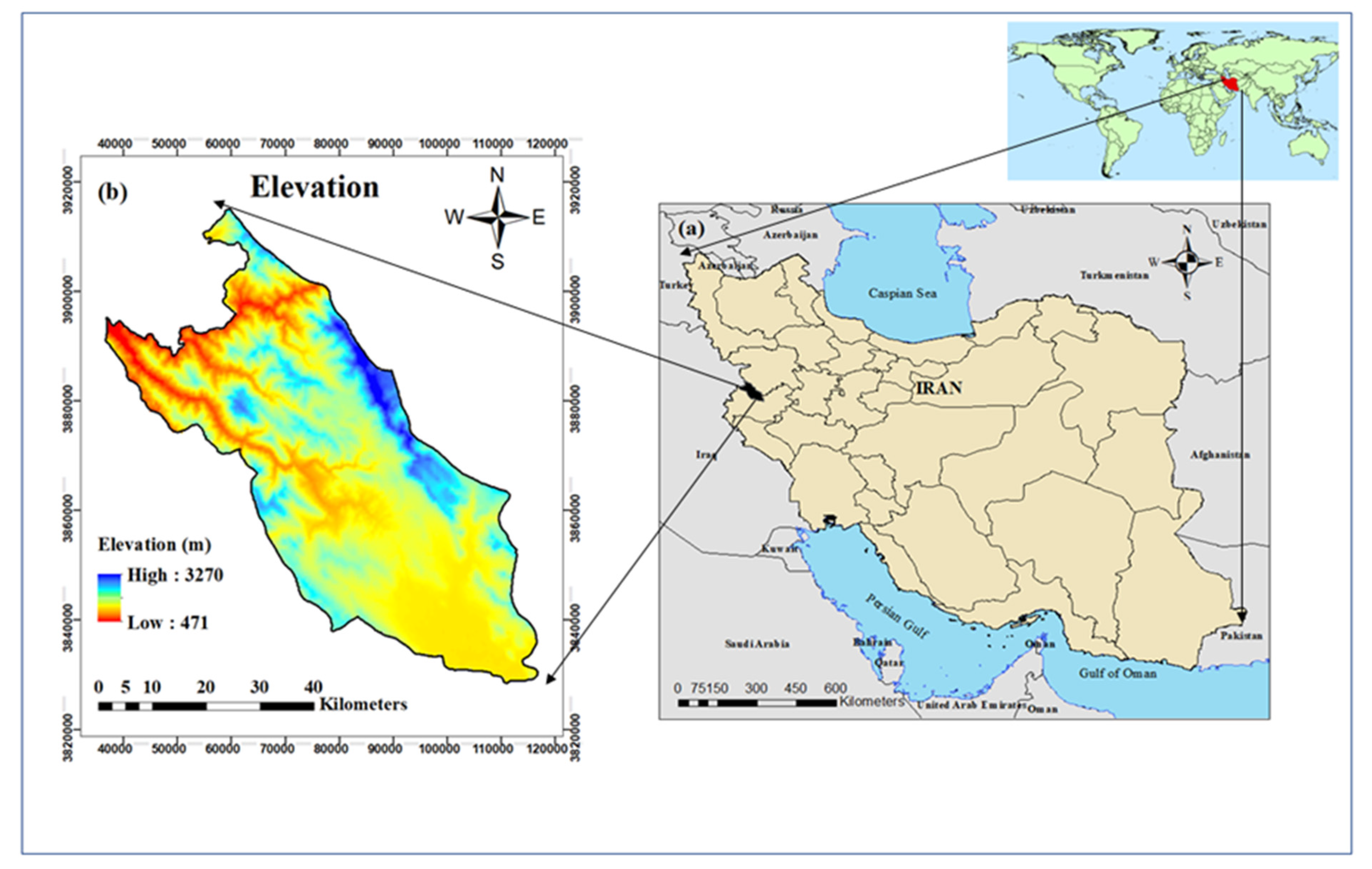
2.1. Study Area
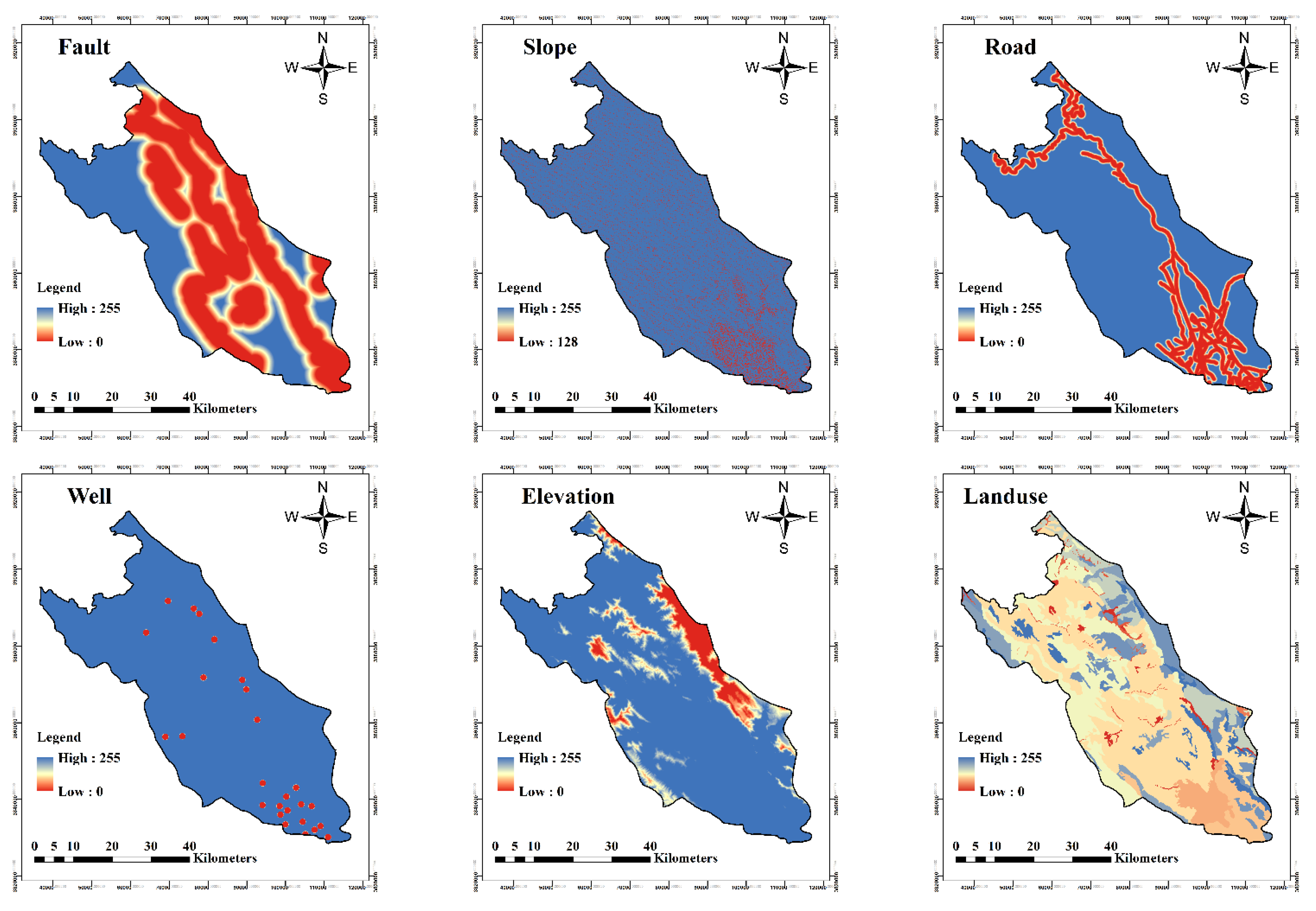
2.2. Data Preparation
Description of Factors and Constraints
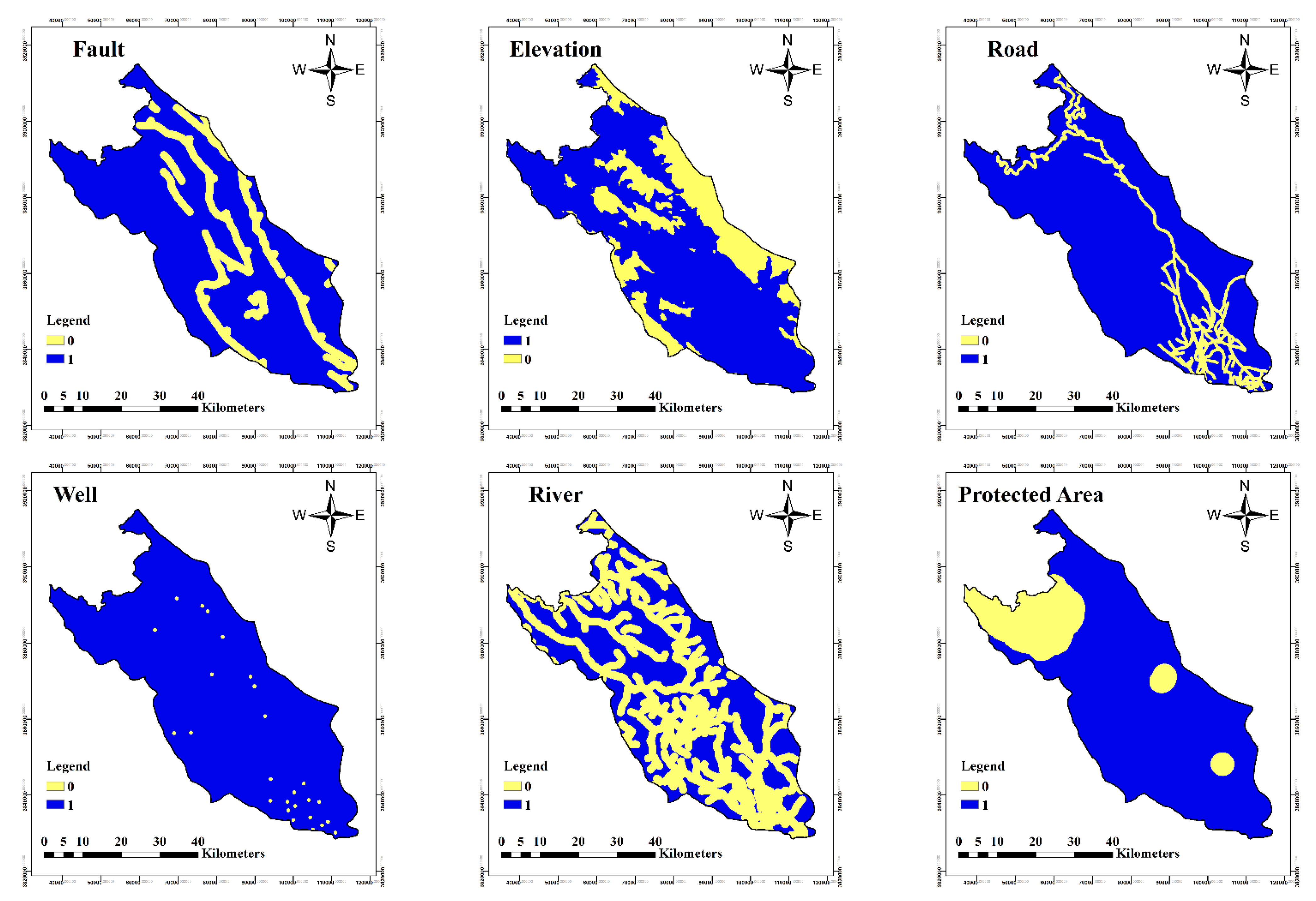
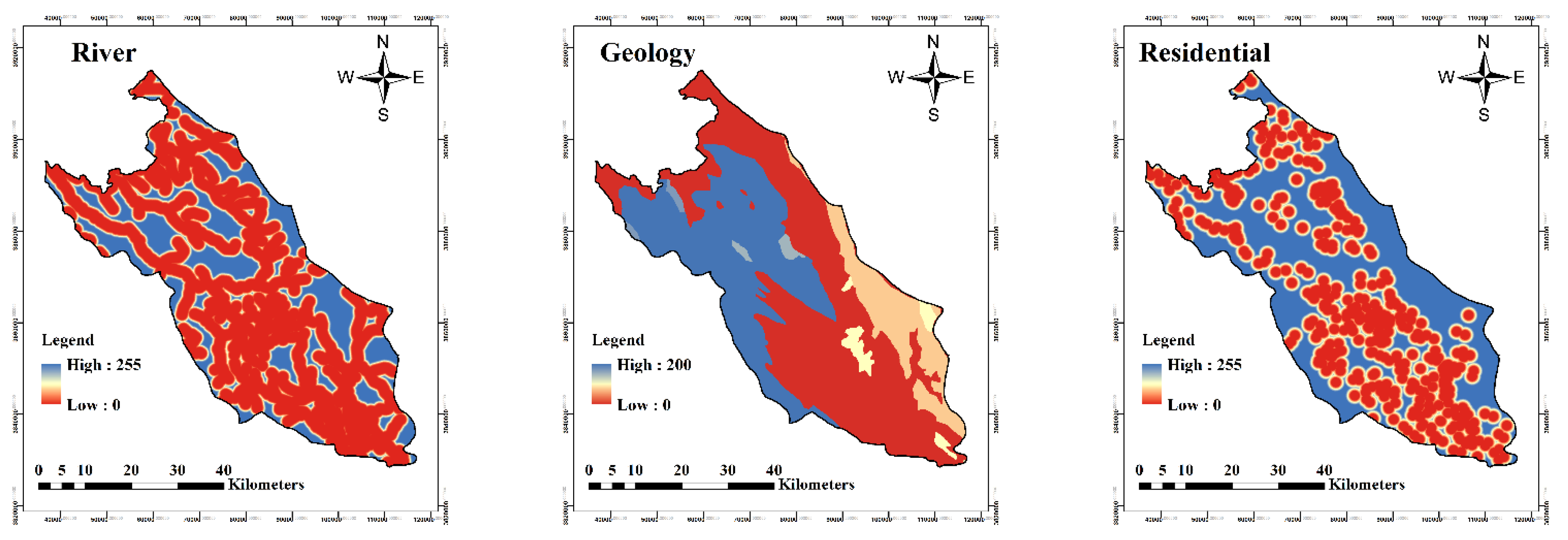
- Factors
- Constraints
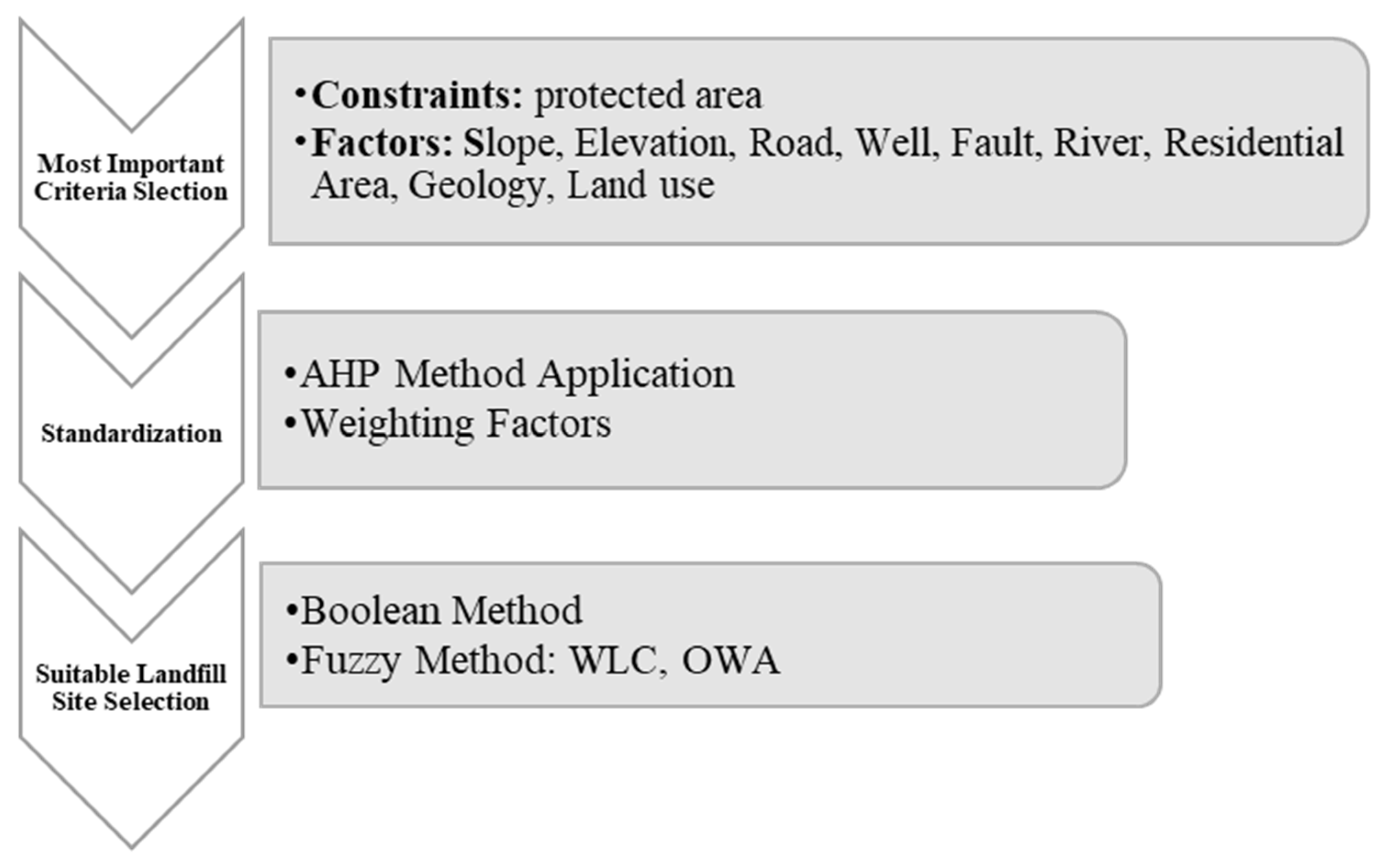
3. Methodology
3.1. Research Framework
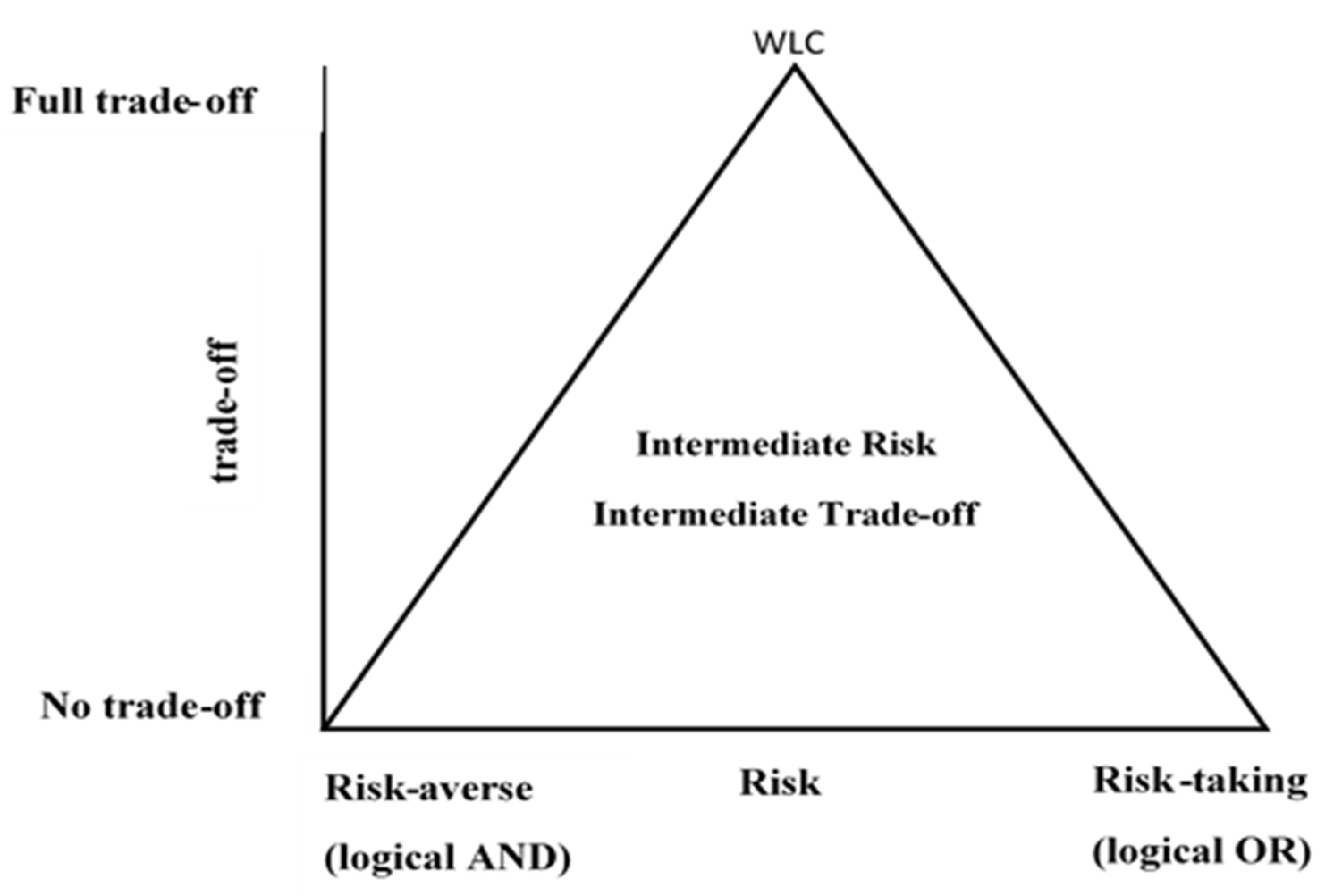
3.1.1. Weighted Linear Combination
3.1.2. Ordered Weighted Averaging
4. Results and Discussion
5. Conclusions
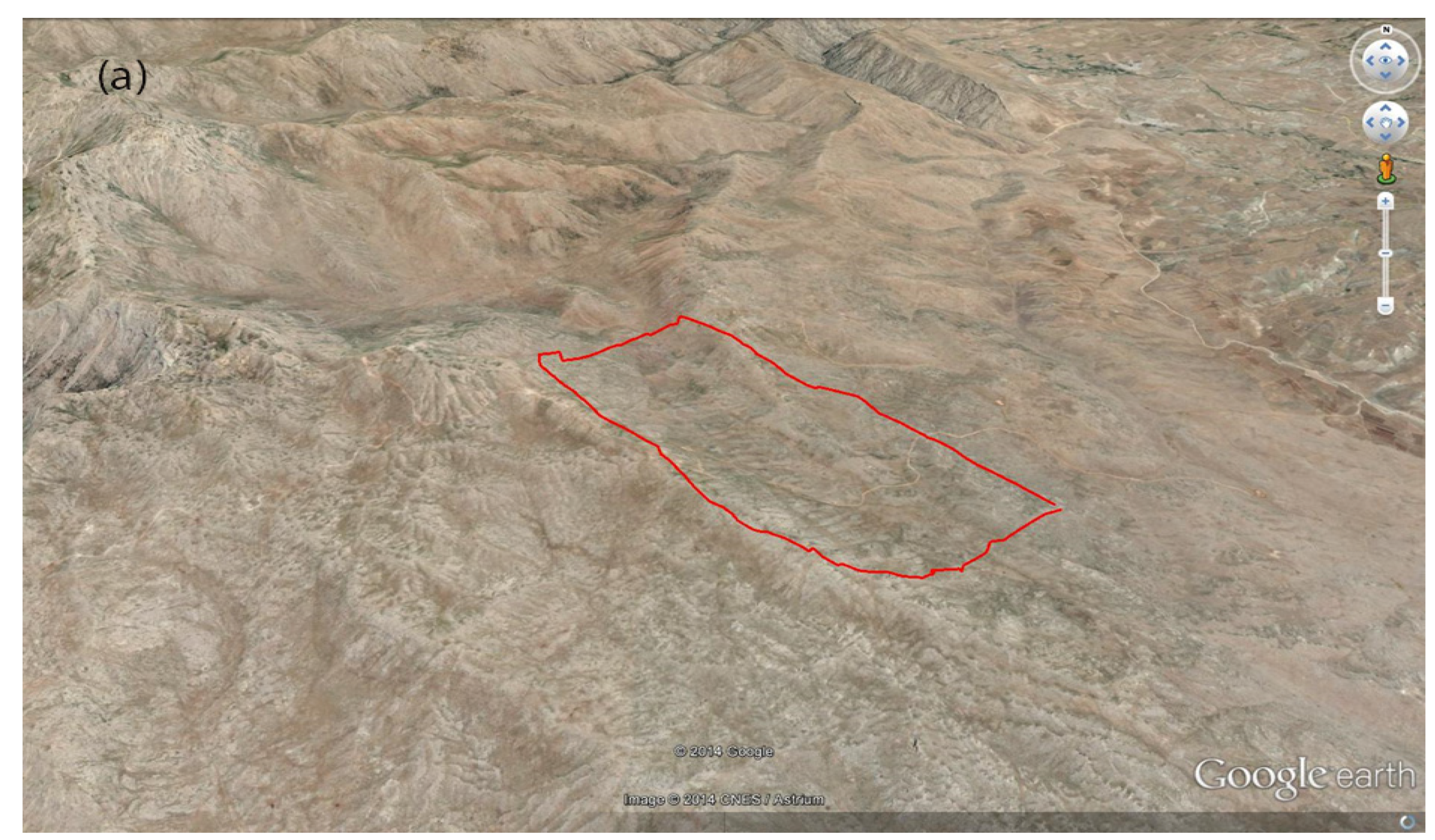
- The location of the case study is in a mountainous area with steep slopes which decreases the final suitability. By surveying the current landfills in these three cities, it was concluded that some criteria are not regarded, such as site area for future, distance from the residential area, well, fault, river, and agriculture.
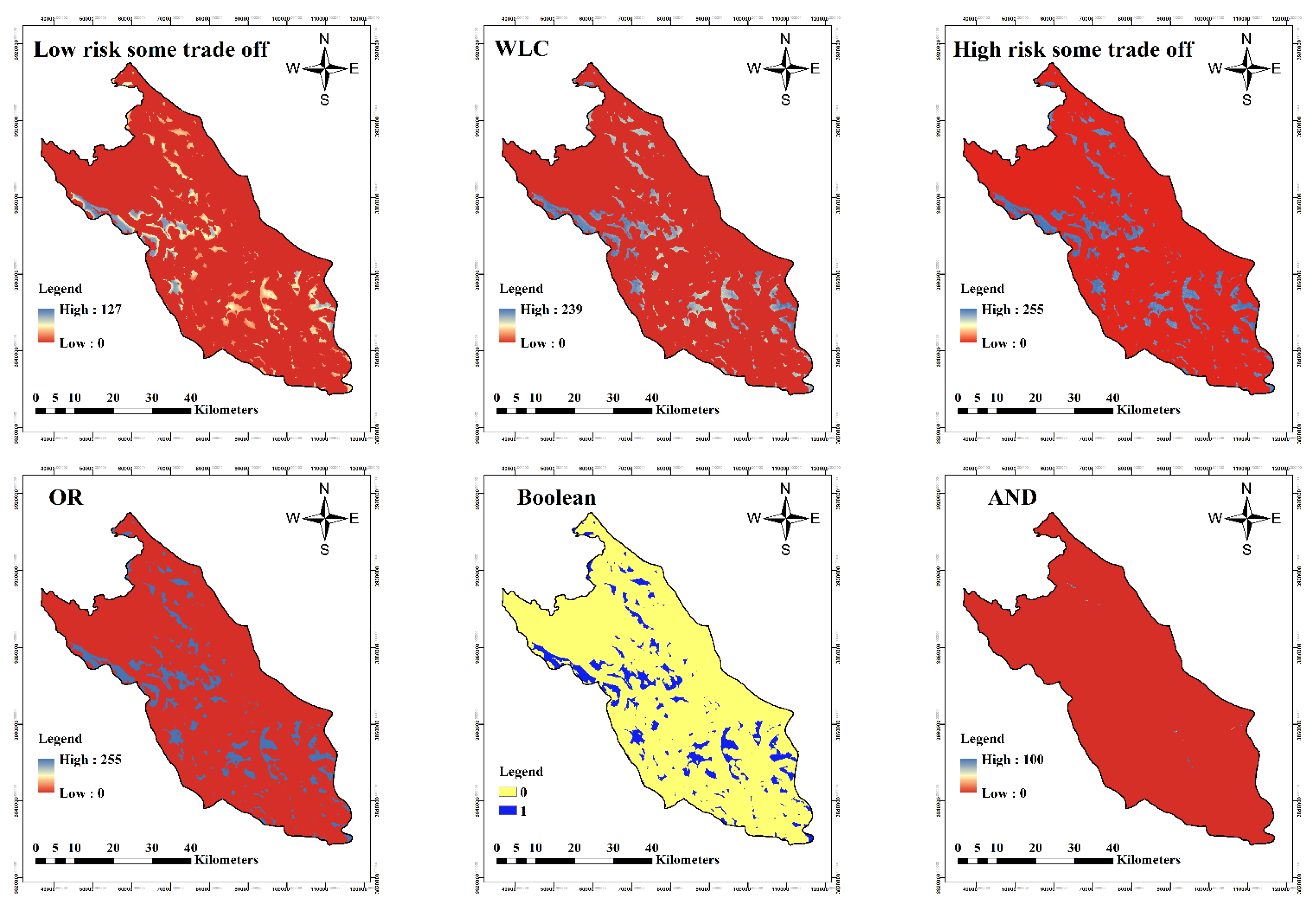
- Due to the different criteria units used in the site selection, the final data were standardized by weighting the criteria, and then the suitability map was produced. Therefore, in the Boolean method, there is a limit to the selection of places that have little area. Among these methods, OWA and WLC showed better efficiency, due to the constraint in the Boolean method.
- Out of 15 sites that were chosen based on the required criteria, two sites were considered the most suitable candidates since they matched all the requirements. Ultimately, only one site was introduced in this research based on land use, economics, social criteria, and other factors.
Author Contributions
Funding
Data Availability Statement
Acknowledgments
Conflicts of Interest
References
- Rahimi, S.; Hafezalkotob, A.; Monavari, S.M.; Hafezalkotob, A.; Rahimi, R. Sustainable landfill site selection for municipal solid waste based on a hybrid decision-making approach: Fuzzy group BWM-MULTIMOORA-GIS. J. Clean. Prod. 2020, 248, 119186. [Google Scholar] [CrossRef]
- Sayadi, M.; Rezaei, M.; Rezaei, A. Fraction distribution and bioavailability of sediment heavy metals in the environment surrounding MSW landfill: A case study. Environ. Monit. Assess. 2015, 187, 4110. [Google Scholar] [CrossRef]
- Golkar, F.; Mousavi, S.M. Variation of XCO2 anomaly patterns in the Middle East from OCO-2 satellite data. Int. J. Digit. Earth 2022, 15, 1218–1234. [Google Scholar] [CrossRef]
- Mousavi, S.M.; Dinan, N.M.; Ansarifard, S.; Sonnentag, O. Analyzing spatio-temporal patterns in atmospheric carbon dioxide concentration across Iran from 2003 to 2020. Atmos. Environ. X 2022, 14, 100163. [Google Scholar] [CrossRef]
- Mallick, J. Municipal Solid Waste Landfill Site Selection Based on Fuzzy-AHP and Geoinformation Techniques in Asir Region Saudi Arabia. Sustainability 2021, 13, 1538. [Google Scholar] [CrossRef]
- Şener, E.; Şener, Ş. Landfill site selection using integrated fuzzy logic and analytic hierarchy process (AHP) in lake basins. Arab. J. Geosci. 2020, 13, 1130. [Google Scholar] [CrossRef]
- Javaheri, H.; Nasrabadi, T.; Jafarian, M.; Rowshan, G.; Khoshnam, H. Site selection of municipal solid waste landfills using analytical hierarchy process method in a geographical information technology environment in Giroft. J. Environ. Health Sci. Eng. 2006, 3, 177–184. [Google Scholar]
- Joshi, R.; Ahmed, S. Status and challenges of municipal solid waste management in India: A review. Cogent Environ. Sci. 2016, 2, 1139434. [Google Scholar] [CrossRef]
- Mandal, K. Review on evolution of municipal solid waste management in India: Practices, challenges and policy implications. J. Mater. Cycles Waste Manag. 2019, 21, 1263–1279. [Google Scholar]
- Besharati Fard, M.; Hamidi, D.; Ebadi, M.; Alavi, J.; McKay, G. Optimum landfill site selection by a hybrid multi-criteria and multi-Agent decision-making method in a temperate and humid climate: BWM-GIS-FAHP-GT. Sustain. Cities Soc. 2022, 79, 103641. [Google Scholar] [CrossRef]
- David, V.E.; John, Y.; Hussain, S. Rethinking sustainability: A review of Liberia’s municipal solid waste management systems, status, and challenges. J. Mater. Cycles Waste Manag. 2020, 22, 1299–1317. [Google Scholar] [CrossRef]
- Nabavi-Pelesaraei, A.; Mohammadkashi, N.; Naderloo, L.; Abbasi, M.; Chau, K.-W. Principal of environmental life cycle assessment for medical waste during COVID-19 outbreak to support sustainable development goals. Sci. Total Environ. 2022, 827, 154416. [Google Scholar] [CrossRef] [PubMed]
- Nanda, S.; Berruti, F. Municipal solid waste management and landfilling technologies: A review. Environ. Chem. Lett. 2021, 19, 1433–1456. [Google Scholar] [CrossRef]
- Pujara, Y.; Pathak, P.; Sharma, A.; Govani, J. Review on Indian Municipal Solid Waste Management practices for reduction of environmental impacts to achieve sustainable development goals. J. Environ. Manag. 2019, 248, 109238. [Google Scholar] [CrossRef]
- Babalola, A.; Busu, I. Selection of Landfill Sites for Solid Waste Treatment in Damaturu Town-Using GIS Techniques. J. Environ. Prot. 2011, 2, 1–10. [Google Scholar] [CrossRef]
- Rezaeisabzevar, Y.; Bazargan, A.; Zohourian, B. Landfill site selection using multi criteria decision making: Influential factors for comparing locations. J. Environ. Sci. 2020, 93, 170–184. [Google Scholar] [CrossRef]
- Bottero, M.; Comino, E.; Riggio, V. Application of the analytic hierarchy process and the analytic network process for the assessment of different wastewater treatment systems. Environ. Model. Softw. 2011, 26, 1211–1224. [Google Scholar] [CrossRef]
- Fernando, R.L.S. Solid waste management of local governments in the Western Province of Sri Lanka: An implementation analysis. Waste Manag. 2019, 84, 194–203. [Google Scholar] [CrossRef]
- Rahmasary, A.N.; Robert, S.; Chang, I.; Jing, W.; Park, J.; Bluemling, B.; Koop, S.; van Leeuwen, K. Overcoming the challenges of water, waste and climate change in Asian cities. Environ. Manag. 2019, 63, 520–535. [Google Scholar] [CrossRef]
- Abdel-Shafy, H.I.; Mansour, M.S. Solid waste issue: Sources, composition, disposal, recycling, and valorization. Egypt. J. Pet. 2018, 27, 1275–1290. [Google Scholar] [CrossRef]
- Isalou, A.; Zamani, V.; Shahmoradi, B.; Alizadeh, H. Landfill site selection using integrated fuzzy logic and analytic network process (F-ANP). Environ. Earth Sci. 2013, 68, 1745–1755. [Google Scholar] [CrossRef]
- Rouhani, A. Municipal Solid Waste Disposal Site Selection Using Remote Sensing Technology and AHP Process (Case Study: Khesht city, Fars Province, Iran). Brill. Eng. 2021, 3, 4535. [Google Scholar] [CrossRef]
- Akbari, V.; Rajabi, M.; Chavoshi, S.; Shams, R. Landfill site selection by combining GIS and fuzzy multi criteria decision analysis, case study: Bandar Abbas, Iran. World Appl. Sci. J. 2008, 3, 39–47. [Google Scholar]
- Curcic, S.; Tadic, D.; Pavlovic, M.; Arsovski, S.; Milunovic, S. Fuzzy multi-criteria model for selecting the best location for a regional landfill. Rev. Chim. 2011, 62, 825–831. [Google Scholar]
- Rezazadeh, M.; Seyedmahalleh, E.S.; Seyedmahalleh, E.S.; Mehrdadi, N.; Kootenaei, F.G. Landfill Site Selection for Babol Using Fuzzy logic Method. J. Civ. Eng. Urban. 2014, 4, 261–265. [Google Scholar]
- Danesh, G.; Monavari, M.; Omrani, G.A.; Karbasi, A.; Farsad, F. Application of Multi-Criteria Decision-Making Models Based on Geographic Information Systems in Locating Hazardous Waste Disposal Sites (Case Study: Bushehr Province). Environ. Sci. Technol. 2019, 23, 87–101. [Google Scholar]
- Sisay, G.; Gebre, S.L.; Getahun, K. GIS-based potential landfill site selection using MCDM-AHP modeling of Gondar Town, Ethiopia. Afr. Geogr. Rev. 2020, 40, 105–124. [Google Scholar] [CrossRef]
- Dashtian, A.; Rouhani, A.; Dashtian, A. Municipal Solid Waste Disposal Site Selection Using Remote Sensing Technology and AHP Process (Case Study: Khesht city, Fars Province, Iran). J. Brill. Eng. 2022, 2, 4535. [Google Scholar]
- Kaghazchi, M.E.; Pourmanafi, S.; Peykanpour Fard, R. Urban landfill site selection with combined environmental and socio-economic criteria in Naein County and estimation of its possible emitted biogas. Environ. Sci. 2021, 19, 53–70. [Google Scholar] [CrossRef]
- Mortazavi Chamchali, M.; Mohebbi Tafreshi, A.; Mohebbi Tafreshi, G. Utilizing GIS linked to AHP for landfill site selection in Rudbar County of Iran. Geo. J. 2021, 86, 163–183. [Google Scholar] [CrossRef]
- Chabok, M.; Asakereh, A.; Bahrami, H.; Jaafarzadeh, N.O. Selection of MSW landfill site by fuzzy-AHP approach combined with GIS: Case study in Ahvaz, Iran. Environ. Monit. Assess. 2020, 192, 433. [Google Scholar] [CrossRef]
- Khorsandi, H.; Faramarzi, A.; Aghapour, A.A.; Jafari, S.J. Landfill site selection via integrating multi-criteria decision techniques with geographic information systems: A case study in Naqadeh, Iran. Environ. Monit. Assess. 2019, 191, 730. [Google Scholar] [CrossRef]
- Omidikhah Deylami, M.; Monavari, M.; Omrani, G.A. Landfill Site Selection with Regional and Local Screening Method in East of Guilan Province. Town Ctry. Plan. 2013, 5, 101–132. [Google Scholar] [CrossRef]
- Manguri, S.B.H.; Hamza, A.A. Sanitary Landfill Site Selection Using Spatial-AHP for Pshdar Area, Sulaymaniyah, Kurdistan Region/Iraq. Iran. J. Sci. Technol. Trans. Civ. Eng. 2022, 46, 1345–1358. [Google Scholar] [CrossRef]
- Benezzine, G.; Zouhri, A.; Koulali, Y. AHP and GIS-Based Site Selection for a Sanitary Landfill: Case of Settat Province, Morocco. J. Ecol. Eng. 2022, 23, 1–13. [Google Scholar] [CrossRef]
- Carević, I.; Sibinović, M.; Manojlović, S.; Batoćanin, N.; Petrović, A.S.; Srejić, T. Geological Approach for landfill site selection: A case study of Vršac Municipality, Serbia. Sustainability 2021, 13, 7810. [Google Scholar] [CrossRef]
- Kilicoglu, C.; Cetin, M.; Aricak, B.; Sevik, H. Site selection by using the multi-criteria technique—a case study of Bafra, Turkey. Environ. Monit. Assess. 2020, 192, 608. [Google Scholar] [CrossRef]
- Asif, K.; Chaudhry, M.N.; Ashraf, U.; Ali, I.; Ali, M. A GIS-based multi-criteria evaluation of landfill site selection in Lahore, Pakistan. Pol. J. Environ. Stud. 2020, 29, 1511–1521. [Google Scholar] [CrossRef]
- Barzehkar, M.; Dinan, N.M.; Mazaheri, S.; Tayebi, R.M.; Brodie, G.I. Landfill site selection using GIS-based multi-criteria evaluation (case study: SaharKhiz Region located in Gilan Province in Iran). SN Appl. Sci. 2019, 1, 1082. [Google Scholar] [CrossRef]
- Chamchali, M.M.; Ghazifard, A. A comparison of fuzzy logic and TOPSIS methods for landfill site selection according to field visits, engineering geology approach and geotechnical experiments (case study: Rudbar County, Iran). Waste Manag. Res. 2021, 39, 325–350. [Google Scholar] [CrossRef]
- Pasalari, H.; Nodehi, R.N.; Mahvi, A.H.; Yaghmaeian, K.; Charrahi, Z. Landfill site selection using a hybrid system of AHP-Fuzzy in GIS environment: A case study in Shiraz city, Iran. Methods X 2019, 6, 1454–1466. [Google Scholar] [CrossRef] [PubMed]
- Zarin, R.; Azmat, M.; Naqvi, S.R.; Saddique, Q.; Ullah, S. Landfill site selection by integrating fuzzy logic, AHP, and WLC method based on multi-criteria decision analysis. Environ. Sci. Pollut. Res. Int. 2021, 28, 19726–19741. [Google Scholar] [CrossRef]
- Ghosh, S.; Das Chatterjee, N.; Dinda, S. Urban ecological security assessment and forecasting using integrated DEMATEL-ANP and CA-Markov models: A case study on Kolkata Metropolitan Area, India. Sustain. Cities Soc. 2021, 68, 102773. [Google Scholar] [CrossRef]
- Mohsin, M.; Ali, S.A.; Shamim, S.K.; Ahmad, A. A GIS-based novel approach for suitable sanitary landfill site selection using integrated fuzzy analytic hierarchy process and machine learning algorithms. Environ. Sci. Pollut. Res. Int. 2022, 29, 31511–31540. [Google Scholar] [CrossRef] [PubMed]
- Ali, S.A.; Parvin, F.; Al-Ansari, N.; Pham, Q.B.; Ahmad, A.; Raj, M.S.; Anh, D.T.; Ba, L.H.; Thai, V.N. Sanitary landfill site selection by integrating AHP and FTOPSIS with GIS: A case study of Memari Municipality, India. Environ. Sci. Pollut. Res. Int. 2021, 28, 7528–7550. [Google Scholar] [CrossRef] [PubMed]
- Majid, M.; Mir, B.A. Landfill site selection using GIS based multi criteria evaluation technique. A case study of Srinagar city, India. Environ. Chall. 2021, 3, 100031. [Google Scholar] [CrossRef]
- Ali, S.A.; Ahmad, A. Suitability analysis for municipal landfill site selection using fuzzy analytic hierarchy process and geospatial technique. Environ. Earth Sci. 2020, 79, 227. [Google Scholar] [CrossRef]
- Karimi, H.; Amiri, S.; Huang, J.; Karimi, A. Integrating GIS and multi-criteria decision analysis for landfill site selection, case study: Javanrood County in Iran. Int. J. Environ. Sci. Technol. 2019, 16, 7305–7318. [Google Scholar] [CrossRef]
- Al-Ruzouq, R.; Abdallah, M.; Shanableh, A.; Alani, S.; Obaid, L.; Gibril, M.B.A. Waste to energy spatial suitability analysis using hybrid multi-criteria machine learning approach. Environ. Sci. Pollut. Res. 2022, 29, 2613–2628. [Google Scholar] [CrossRef]
- Bilgilioglu, S.S.; Gezgin, C.; Orhan, O.; Karakus, P. A GIS-based multi-criteria decision-making method for the selection of potential municipal solid waste disposal sites in Mersin, Turkey. Environ. Sci. Pollut. Res. 2022, 29, 5313–5329. [Google Scholar] [CrossRef]
- Cobos-Mora, S.L.; Guamán-Aucapiña, J.; Zúñiga-Ruiz, J. Suitable site selection for transfer stations in a solid waste management system using analytical hierarchy process as a multi-criteria decision analysis: A case study in Azuay-Ecuador. Environ. Dev. Sustain. 2022, 1–34. [Google Scholar] [CrossRef]
- Gorsevski, P.V.; Donevska, K.R.; Mitrovski, C.D.; Frizado, J.P. Integrating multi-criteria evaluation techniques with geographic information systems for landfill site selection: A case study using ordered weighted average. Waste Manag. 2012, 32, 287–296. [Google Scholar] [CrossRef] [PubMed]
- Sharifi, M.; Hadidi, M.; Vessali, E.; Mosstafakhani, P.; Taheri, K.; Shahoie, S.; Khodamoradpour, M. Integrating multi-criteria decision analysis for a GIS-based hazardous waste landfill sitting in Kurdistan Province, western Iran. Waste Manag. 2009, 29, 2740–2758. [Google Scholar] [CrossRef]
- Soleymani, M.; Asakereh, A.; Safieddin Ardebili, S.M. A GIS-based multi-criteria fuzzy approach to select a suitable location for a MSW-based power plant and landfill: A case study, Khuzestan province, Iran. Environ. Monit. Assess. 2022, 194, 1–20. [Google Scholar] [CrossRef]
- Eghtesadifard, M.; Afkhami, P.; Bazyar, A. An integrated approach to the selection of municipal solid waste landfills through GIS, K-Means and multi-criteria decision analysis. Environ. Res. 2020, 185, 109348. [Google Scholar] [CrossRef] [PubMed]
- Özkan, B.; Özceylan, E.; Sarıçiçek, İ. GIS-based MCDM modeling for landfill site suitability analysis: A comprehensive review of the literature. Environ. Sci. Pollut. Res. 2019, 26, 30711–30730. [Google Scholar] [CrossRef] [PubMed]
- Bahrani, S.; Ebadi, T.; Ehsani, H.; Yousefi, H.; Maknoon, R. Modeling landfill site selection by multi-criteria decision making and fuzzy functions in GIS, case study: Shabestar, Iran. Environ. Earth Sci. 2016, 75, 337. [Google Scholar] [CrossRef]
- Rahmat, Z.G.; Niri, M.V.; Alavi, N.; Goudarzi, G.; Babaei, A.A.; Baboli, Z.; Hosseinzadeh, M. Landfill site selection using GIS and AHP: A case study: Behbahan, Iran. KSCE J. Civ. Eng. 2017, 21, 111–118. [Google Scholar] [CrossRef]
- Soroudi, M.; Omrani, G.; Moataar, F.; Jozi, S.A. Modelling an Integrated Fuzzy Logic and Multi-Criteria Approach for Land Capability Assessment for Optimized Municipal Solid Waste Landfill Siting Yeast. Pol. J. Environ. Stud. 2018, 27, 313–323. [Google Scholar] [CrossRef]
- Mahini, A.S.; Gholamalifard, M. Siting MSW landfills with a weighted linear combination methodology in a GIS environment. Int. J. Environ. Sci. Technol. 2006, 3, 435–445. [Google Scholar] [CrossRef]
- Drobne, S.; Lisec, A. Multi-attribute decision analysis in GIS: Weighted linear combination and ordered weighted averaging. Informatica 2009, 33, 459–474. [Google Scholar]
- Eastman, J. IDRISI Selva: Guide to GIS and Image Processing; Clark University: Worcester, MA, USA, 2012. [Google Scholar]
- VK, E.A.D. A GIS Multicriteria Model for Landfill Sitting. Glob. NEST J. 2007, 9, 29–34. [Google Scholar]
- Schernthanner, H. Fuzzy Logic Approach for Landslide Susceptibility Mapping, “Rio Blanco”, Nicaragua; na: 2005. Available online: https://www.researchgate.net/publication/285386772_Fuzzy_logic_approach_for_landslide_susceptibility_mapping_Rio_Blanco_Nicaragua_Schernthanner_Harald (accessed on 11 September 2022).
- Mahiny, A.S.; Gholamalifard, M. Linking SLEUTH urban growth modeling to multi criteria evaluation for a dynamic allocation of sites to landfill. Proceedings of International Conference on Computational Science and Its Applications, Santander, Spain, 20–23 June 2011; pp. 32–43. [Google Scholar]
- Yager, R.R. On ordered weighted averaging aggregation operators in multicriteria decisionmaking. IEEE Trans. Syst. Man Cybern. 1988, 18, 183–190. [Google Scholar] [CrossRef]
- Ferretti, V.; Pomarico, S. Ecological land suitability analysis through spatial indicators: An application of the Analytic Network Process technique and Ordered Weighted Average approach. Ecol. Indic. 2013, 34, 507–519. [Google Scholar] [CrossRef]
- Jiang, H.; Eastman, J.R. Application of fuzzy measures in multi-criteria evaluation in GIS. Int. J. Geogr. Inf. Sci. 2000, 14, 173–184. [Google Scholar] [CrossRef]
- Yager, R.R. Including importances in OWA aggregations using fuzzy systems modeling. IEEE Trans. Fuzzy Syst. 1998, 6, 286–294. [Google Scholar] [CrossRef]
- Malczewski, J. Fuzzy screening for land suitability analysis. Geogr. Environ. Model. 2002, 6, 27–39. [Google Scholar] [CrossRef]
- Malczewski, J. GIS and Multicriteria Decision Analysis; John Wiley & Sons: Hoboken, NJ, USA, 1999. [Google Scholar]
- Ayeni, B. The design of spatial decision support systems in urban and regional planning. In Decision Support Systems in Urban Planning; Routledge: London, UK, 2003; pp. 20–33. [Google Scholar]
- Khan, D.; Samadder, S.R. A simplified multi-criteria evaluation model for landfill site ranking and selection based on AHP and GIS. J. Environ. Eng. Landsc. Manag. 2015, 23, 267–278. [Google Scholar] [CrossRef]


| Population | Average Annual Temperatures (°C) | Precipitation (mm) | Forest Areas (ha) | Dryland Cultivation (ha) | Irrigated Cultivation (ha) | Solid Waste Production (ton/day) | |
|---|---|---|---|---|---|---|---|
| Javanrood | 75,169 | 16.5 | 590.9 | 47,925 | 19,064 | 2647 | 100 |
| Paveh | 60,431 | 15.6 | 803 | 46,875 | 384 | 1854 | 40 |
| Ravansar | 47,657 | 15.1 | 536.9 | 18,225 | 26,028 | 9784 | 30 |
| total | 183,257 | - | 180 |
| Criteria | Buffer Area | Rating | Reference | |
|---|---|---|---|---|
| Slope | 32°< 24–32° 16–24° 8–16° 8°> | 1 2 3 4 5 | [41] | |
| Elevation | 300 m> 2500 m< 300–900 m 900–1500 m 1500–2500m | 1 2 3 4 5 | [55] | |
| River | 0–1000 m 1000–1500 m 1500–2000 m 2000–2500 m 2500 m< | 1 2 3 4 5 | [56] | |
| Well | 0–500 m 500–1000 m 1000–1500 m 1500–2000 m 2000 m< | 1 2 3 4 5 | [16] | |
| Road | 0–300 m 1500 m< 300–600 m 600–900 m 900–1500 m | 1 2 3 4 5 | [57] | |
| Fault | 0–500 m 500–1000 m 1000–1500 m 1500–2000 m 2000 m< | 1 2 3 4 5 | [58] | |
| Residential area | Urban area | 0–1000 m 1000–2000 m 2000–3000 m 3000- 4000 m 4000 m< | 1 2 3 4 5 | [31] |
| Rural area | 0–500 m 500–1500 m 1500–2000 m 2000–2500 m 2500 m< | 1 2 3 4 5 | ||
| Protected area | 0–1000 m 1000–1500 m 1500–2000 m 2000–2500 m 2500 m< | 1 2 3 4 5 | [59] | |
| Factor | Control Points a, b | Control Point c, d | Function | Function | Boolean Logic | Environmental Condition |
|---|---|---|---|---|---|---|
| Slope | 11 | 30 | Sigmoidal | decreasing | - | - |
| Elevation | 1800 | 3000 | Linear | decreasing | 1800–3000 | - |
| Distance from river | 1000 | 2000 | Sigmoidal | increasing | 1000 | 500–800 |
| Distance from road | 300 | 1000 | Sigmoidal | decreasing | 400 | 300 |
| Distance from well | 600 | 900 | Sigmoidal | increasing | 500 | 400 |
| Land use | 0 | 0.8 | Linear | increasing | - | - |
| Geology | 0 | 0.8 | Linear | increasing | - | - |
| Distance from fault | 2000 | 5000 | Linear | Increasing | 1000 | 200 |
| Distance from residential areas | 1000 | 2000 | Linear | increasing | 1000 | 1000 |
| 1 | 2 | 3 | 4 | 5 | 6 | 7 | 8 | 9 | Weights of Factors | Consistency Ratio | ||
|---|---|---|---|---|---|---|---|---|---|---|---|---|
| 1 | Geology | 1 | 0.0312 | CR = 0.01 | ||||||||
| 2 | Elevation | 5 | 1 | 0.1705 | ||||||||
| 3 | Distance from river | 2 | 1.3 | 1 | 0.0571 | |||||||
| 4 | Distance from road | 2 | 1.3 | 1 | 1 | 0.0571 | ||||||
| 5 | Distance from well | 2 | 1.3 | 1 | 1 | 1 | 0.0571 | |||||
| 6 | Land use | 4 | 1.2 | 2 | 2 | 2 | 1 | 0.1058 | ||||
| 7 | Slope | 7 | 2 | 5 | 5 | 5 | 3 | 1 | 0.2936 | |||
| 8 | Distance from fault | 5 | 1 | 3 | 3 | 3 | 2 | 1.2 | 1 | 0.1705 | ||
| 9 | Distance from residential areas | 2 | 1.3 | 1 | 1 | 1 | 1.3 | 1.5 | 1.3 | 1 | 0.0571 |
| Land Use | Fuzzy Value | Boolean Value |
|---|---|---|
| Agriculture | 102 | 1 |
| Garden | 55 | 1 |
| Dense forest | 128 | 1 |
| Dryland farming | 128 | 1 |
| Good range | 178 | 1 |
| Low forest | 153 | 1 |
| River | 0 | 0 |
| Mix(agriculture-garden) | 76 | 1 |
| Mix (agriculture-dryland farming) | 115 | 1 |
| Mix (dryland farming-x) | 128 | 1 |
| Mix (low forest_ x) | 165 | 1 |
| Mix (moderate forest_ x) | 140 | 1 |
| Mix (moderate range_ x) | 216 | 1 |
| Mix (poor range_ x) | 242 | 1 |
| Mix (urban-x) | 0 | 0 |
| Moderate forest | 128 | 1 |
| Moderate range | 229 | 1 |
| Poor range | 255 | 1 |
| Rock | 0 | 0 |
| Urban | 0 | 0 |
| Water | 0 | 0 |
| Woodland | 0 | 1 |
| Geology | Fuzzy | Boolean |
|---|---|---|
| Bangestan formation | 200 | 1 |
| Shely limestone | 170 | 1 |
| Sandstone | 100 | 1 |
| Biston limestone | 75 | 1 |
| Traces/Deposit | 25 | 0 |
| Method | Order | Trade-Off | ORness | ANDness |
|---|---|---|---|---|
| AND | (1, 0, 0, 0, 0, 0, 0, 0, 0) | 0 | 0 | 1 |
| LRST (MIDAND) | (0.5, 0.2, 0.1, 0.06, 0.05, 0.04, 0.03, 0.02, 0) | 0.61 | 0.165 | 0.835 |
| WLC | (0.0909, 0.0909, 0.0909, 0.0909, 0.0909, 0.0909, 0.0909, 0.0909, 0.0909,) | 1 | 0.5 | 0.5 |
| HRST (MIDOR) | (0, 0.02, 0.03, 0.04, 0.05, 0.06, 0.1, 0.2, 0.5) | 0.61 | 0.8375 | 0.1625 |
| OR | (0, 0, 0, 0, 0, 0, 0, 0, 0, 0, 1) | 0 | 1 | 0 |
| New ID | Hectare | Average | Max Value | Min Value | Old ID |
|---|---|---|---|---|---|
| 1 | 48 | 233 | 235 | 227 | 1547 |
| 2 | 136 | 231 | 235 | 225 | 1552 |
| 3 | 115 | 230 | 232 | 225 | 1687 |
| 4 | 1963 | 228 | 236 | 225 | 2 |
| 5 | 40 | 228 | 232 | 225 | 1627 |
| New ID | Hectare | Average | Max Value | Min Value | Old ID |
|---|---|---|---|---|---|
| 1 | 42 | 106 | 119 | 80 | 13 |
| 2 | 65 | 100 | 110 | 80 | 31 |
| 3 | 58 | 99 | 110 | 80 | 129 |
| 4 | 98 | 98 | 110 | 80 | 206 |
| New ID | Hectare | Average | Max Value | Min Value | Old ID |
|---|---|---|---|---|---|
| 1 | 633 | 253 | 253 | 253 | 2 |
| 2 | 47 | 253 | 253 | 253 | 150 |
| 3 | 152 | 253 | 253 | 253 | 546 |
| 4 | 75 | 253 | 253 | 253 | 687 |
| 5 | 117 | 253 | 253 | 253 | 725 |
| 6 | 40 | 253 | 253 | 253 | 780 |
Publisher’s Note: MDPI stays neutral with regard to jurisdictional claims in published maps and institutional affiliations. |
© 2022 by the authors. Licensee MDPI, Basel, Switzerland. This article is an open access article distributed under the terms and conditions of the Creative Commons Attribution (CC BY) license (https://creativecommons.org/licenses/by/4.0/).
Share and Cite
Mousavi, S.M.; Darvishi, G.; Mobarghaee Dinan, N.; Naghibi, S.A. Optimal Landfill Site Selection for Solid Waste of Three Municipalities Based on Boolean and Fuzzy Methods: A Case Study in Kermanshah Province, Iran. Land 2022, 11, 1779. https://doi.org/10.3390/land11101779
Mousavi SM, Darvishi G, Mobarghaee Dinan N, Naghibi SA. Optimal Landfill Site Selection for Solid Waste of Three Municipalities Based on Boolean and Fuzzy Methods: A Case Study in Kermanshah Province, Iran. Land. 2022; 11(10):1779. https://doi.org/10.3390/land11101779
Chicago/Turabian StyleMousavi, Seyed Mohsen, Golnaz Darvishi, Naghmeh Mobarghaee Dinan, and Seyed Amir Naghibi. 2022. "Optimal Landfill Site Selection for Solid Waste of Three Municipalities Based on Boolean and Fuzzy Methods: A Case Study in Kermanshah Province, Iran" Land 11, no. 10: 1779. https://doi.org/10.3390/land11101779
APA StyleMousavi, S. M., Darvishi, G., Mobarghaee Dinan, N., & Naghibi, S. A. (2022). Optimal Landfill Site Selection for Solid Waste of Three Municipalities Based on Boolean and Fuzzy Methods: A Case Study in Kermanshah Province, Iran. Land, 11(10), 1779. https://doi.org/10.3390/land11101779