Abstract
Water scarcity is a problem in Brazil’s northern semi-arid domain. Montes Claros is the most populated Minas Gerais city in this context, and its socio-economic problems are related to water consumption and management. Aiming to help assess these problems, this study presents a new hydrogeological characterization. The 3D geological model was developed using drilling data from 125 public wells, field campaigns and satellite images for hydrogeological interpretation. The area has two main different aquifer systems underlying the Vieira River Watershed. The first is a karstic fissured aquifer, located in the Lagoa do Jacaré limestone Formation. The second is fissured aquifer systems in metapelites from the Serra da Santa Helena and Serra da Saudade Formations, which are characterized by low hydraulic transmissivity and locally higher specific capacity zones related to their structural features or carbonate intercalations. Monitoring data from new manual and automatic methods carried out in 16 selected points highlight that variations are related to (1) hydrogeological domains, (2) oscillations related to interference from neighboring wells, and (3) seasonal variation and irregular pluviometry in the region. This is important information that can help update our hydrogeological knowledge, provide information on surface and groundwater flow dynamics, and improve water resource management, with the aim of ensuring sustainability in exploitation.
1. Introduction
The Vieira River watershed is in Montes Claros, southeastern Brazil. It is an important regional economic pole bordering the driest Brazilian region in a predominantly semi-arid climate [1]. Since the 1980s there have been struggles related to water supply and demand in this region [2], which have intensified on account of urban and industrial expansion [3].
In this scenario, the use of groundwater from water-bearing formations has become an important alternative to meet the water needs of the local population. In the 1970s, there was significant agro-industrial development in Montes Claros due to public policies focused on agricultural irrigation and similar incentives. However, such policies triggered water conflicts in the following decade [4].
Population and industrial growth put pressure on surface and groundwater availability [5,6], causing aquifer overexploitation and eventual scarcity [7,8]. This aquifer overexploitation is responsible for extremely significant variations in water table levels, and in constantly expanding urban regions, water quality can also suffer serious damage, which is intensified by the lowering of piezometric levels [9]. Semi-arid regions are even more sensitive to these socioeconomic advances when associated with climate variations and constraints related to water availability. Even as a country with abundant water availability, Brazil presents continental geographic dimensions and climatic and relief variations that provide a totally irregular distribution of these resources, especially in semi-arid areas [10,11,12]. In addition to the social, economic and climatic context, the Vieira River watershed is geologically inserted into a karst environment, which adds complexity to the water availability, especially of groundwater, as well as the local and regional water flow, due to its heterogeneity [13,14,15].
In Brazil, many studies have been developed focusing on water resource management and water scarcity reduction over the last few years [16,17]. In a similar context to the present work, where land use and occupation, climatic aspects and the karst geological environment add specific conditions, other authors have also presented results regarding aquifer characterization, flow modeling and water availability assessment [17,18,19,20,21,22,23,24].
The present research aims to present new results related to the hydrogeological characterization of the Vieira River watershed. To carry this out, the main goals are: (1) to characterize the hydrogeological domains using data from geological mapping, satellite images and publicly available well construction data; and (2) monitor them regularly using automated and manual data for later comparison with rainfall data and different land uses to see and discuss general and local variations. In the water scarcity scenario, we aim to contribute to the assessment of local water availability, especially by discussing new data obtained from surface and groundwater monitoring which could support proposals of water management in the semi-arid environment located in karstic terrains in Montes Claros, Minas Gerais (Brazil).
2. The Vieira River Watershed
2.1. Geography
The Vieira watershed is in Montes Claros, northern Minas Gerais State, Brazil. The studied area is located within two major watersheds: São Francisco River and Verde Grande River (Figure 1). Montes Claros is the largest city in northern Minas Gerais, with 400,000 inhabitants, and is located ca. 422 km from Belo Horizonte, the state capital.
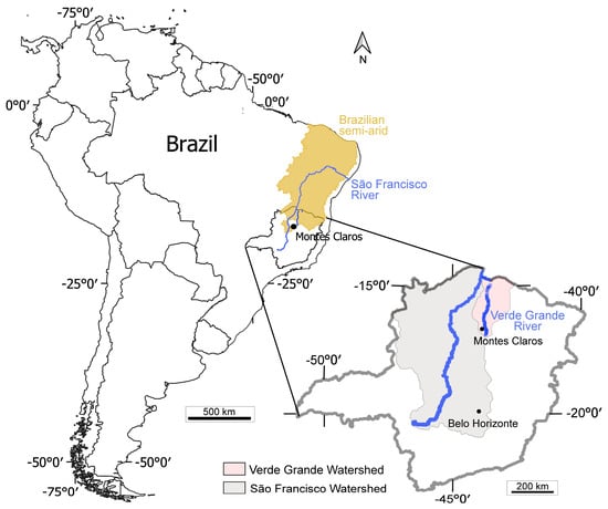
Figure 1.
Location of the studied area in South America. Montes Claros is a city in northern Minas Gerais State, southeastern Brazil, and Verde Grande River is a tributary of the 2860 km long São Francisco River, the largest exclusively Brazilian watershed, occupying 8% of the country with an area of ca. 630,000 km2. The area is also located within the southern part of the Brazilian semi-arid region [25].
In the 1960s, Montes Claros began to be changed by economic and industrial acceleration policies promoted by the Governmental Agency for the Development of the Northeast (Superintendência do Desenvolvimento do Nordeste, SUDENE), which focused on semi-arid regions. Since then, it has been developed into an industrial park that mainly serves the civil construction, health, food production and textile sectors [26,27].
Due to the geographic and climatologic characteristics of the studied region, the rainfall is concentrated in a very well-marked temporal period, with prolonged droughts between the months of April and October, as evidenced in Figure 2. Due to the seasonal characteristic water scarcity, the distribution of water is not always continuous and uniform, and rationing occurs (i.e., when the responsible concessionaire limits the distribution by regions or by time frequency and a minimum amount is supplied to the population). To fill this gap, for decades, the population has been building wells that are mostly not regulated by legislation or even registered. In recent years, COPASA (Companhia de Saneamento de Minas Gerais, the local concessionaire) has also started to use groundwater more frequently, and is now responsible for almost 10% of the water distribution.
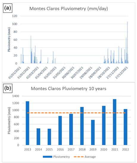
Figure 2.
(a) Rainfall in Montes Claros for the year of 2021 [28], where the dry season from May to September and the rainy season from October to April are well-marked. (b) Pluviometry data for the last ten years in Montes Claros, highlighting average values of 920 mm/year (dotted line) and annual variations [28].
2.2. Hydrography
The Vieira River watershed is included in the Verde Grande River watershed, a tributary of the São Francisco River. Agricultural production that supplies food for important cities, such as Montes Claros, is only possible because of irrigation provided by the Verde Grande River watershed [3].
The entire Montes Claros urban area is in the Vieira River watershed. Regarding pluviometry, the study area presented an average rainfall of around 920 mm/year for the last 10 years (Figure 2b) with smaller values towards the north, which is coincident with the Brazilian semi-arid region (Figure 3a). The region presents a rugged relief, with altitudes ranging from 1036 m in the karst region to 561 m in the Rio Vieira valley (Figure 3b).
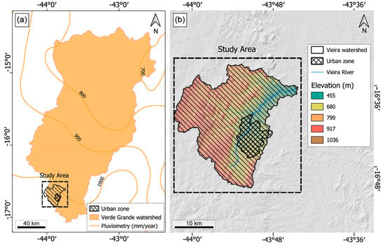
Figure 3.
(a) Studied area (Vieira River watershed) and pluviometry data in the Verde Grande River watershed [29], with rainfall increasing in the south and decreasing in the north when moving further into the Brazilian semi-arid area. (b) Vieira River watershed elevation, with higher ground in the east, and the location of the urban zone in western lower relief areas. The elevation decreases to the east, following the Vieira River. Adapted from [13].
Less than 10% of the Vieira River watershed is occupied by an urban area, which has no relevance for specific agricultural activities. In general, the land mostly comprises forests and rural areas [1].
2.3. Geology
The Vieira River watershed is inserted into the São Francisco Craton [30], a structure formed by Archean and Paleoproterozoic rocks overlayed by Proterozoic and Phanerozoic sedimentary units [31]. The Bambuí Group is the main outcrop in the studied region, and is represented by Proterozoic units that are locally covered by Phanerozoic deposits. Regionally, the Bambuí Group extends over 300,000 km2 along the São Francisco River Basin [32], reaching thicknesses of about 3000 m [33]. The group is divided into five different units [34], with the Sete Lagoas Formation at the base, which is overlayed by the Serra da Santa Helena, Lagoa do Jacaré, Serra da Saudade and Três Marias Formations at the top. Only three of these formations are outcrops in the studied area [35,36], with the Bambuí Group represented by the Serra da Santa Helena, Lagoa do Jacaré and Serra da Saudade Formations.
The basement of the sequence is composed of the metasiltstones of the Serra da Santa Helena Formation overlayed by limestone and metasiltstone of the Lagoa do Jacaré Formation, with metasediments of the Serra da Saudade Formation on top. These stratigraphic packages present smooth kilometric folds with persistent and remarkable faults and fractures in the NNE–SSW direction [36,37].
3. Methodology
To evaluate the actual water scarcity scenarios in the region of the Vieira River watershed, new data and interpretations were generated concerning a detailed geological (mainly geomorphological, structural and lithological) and hydrogeological characterization of the area, with three main features:
- Geology: Satellite image interpretation was performed to define the large geomorphological and structural compartments. The images were obtained from the National Institute for Space Research (Instituto Nacional de Pesquisas Espaciais (INPE) [38] and processed in open QGIS software, which were used to track the basin’s boundaries, carry out photointerpretation, and track large-scale alignments and structures. To detail the geological characterization, field campaigns were conducted and more than 125 geological logs of underground wells were used to build a new geological map and a three-dimensional (3D) model using the Leapfrog Geo software (version 2022.1.0) by Seequent.
- Hydrogeology: Based on new geological information and structural interpretations, the major aquifer systems were individualized. New monitoring data, both manual and automatic, were collected throughout the basin and used to characterize and understand the local and seasonal variations in the groundwater in each lithological domain.
- Monitoring: Field campaigns were carried out to locate and monitor wells with a regular spatial distribution among the different hydrogeological domains. As previously described, due to the large number of unlicensed wells within private properties, a small number of wells could be selected and authorized to install pressure gauges (divers) to obtain automatic readings. Several wells were instrumented and pumped. The spatial well distribution could not be regular considering that most wells are in the Montes Claros urban area and in the metapelitic aquifer domain.
During the field campaigns, five divers (Solinst and Schlumberger pressure sensors) and two baros (Solinst) were installed to obtain data every six hours for over a year, from December 2020 to March 2022, with a total of over 11,000 measures. On the eleven manual wells, the water level was registered by considering a measure associated with the dry and the rainy season, corresponding to August 2021 and March 2022, respectively.
For the automated points, manual readings were obtained from groundwater level meters (wells) and a micromolinet (river) to correlate the pressure data with the potentiometric or water table.
At the Vieira River watershed, sixteen points were selected for groundwater monitorization from the river spring (point 15; Figure 4) to the creek downstream (point 16; Figure 4), and manual (eleven points) and automated (five points) data were collected (Figure 4).
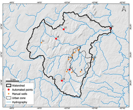
Figure 4.
Spatial distribution of automated and manual water monitorization points in the Vieira River watershed, both superficial and in wells, as well as local hydrography converging into Vieira River. Even though points are spread across Vieira River watershed, most are located near the urban zone.
4. Results
Due to the relevance of water issues in the studied region, state and federal agencies have developed several water management studies and strategies. The region contains a complex karstic aquifer system, and a geological detailed study was the basis for a satisfactory delimitation of aquifer systems, their connections and potential water availability.
4.1. Geology
Some important surface data was obtained in the field campaign (Figure 5). First, there is a more relevant frequency and dominance of metapelitic rocks in the whole eastern flatland region, mostly red and yellowish metasiltstones with intercalations of metaclaystones. In the central part of the watershed, two main occurrences were found: (I) on the top of hills, there is a predominance of limestone (calcarenites to calcilutites), whose color vary between light and dark gray, with intercalations of marls and metasiltstones; and (II) red to yellowish metasiltstones with clay-rich levels and intercalations of carbonates.
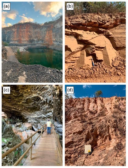
Figure 5.
Examples of the outcropping limestone and metapelites of the Serra da Santa Helena and Lagoa do Jacaré Formations. (a) Limestone quarry (called Sobrita) from Lagoa do Jacaré Formation. (b) Metasiltstone outcrop near the contact region with the carbonatic domain from Lagoa do Jacaré Formation. (c) Lapa Grande Cave from Lagoa do Jacaré Formation. (d) Metasiltstone outcrop from Serra da Santa Helena Formation.
To complement the field data and build a 3D geological model, data from previous work and wells were also used. When comparting field work from previous research and classifications, the central area was considered to be a part of the Lagoa do Jacaré Formation, the western area was related to the Serra da Saudade Formation and the eastern metapelitic rocks could be related to more than one unit. Independently, if it is related to the upper portion of the Serra da Santa Helena Formation or to the basement of the Lagoa do Jacaré Formation, the increasingly restricted occurrence of limestone north of the urban area in topographically flattened surfaces indicates the possibility that the Serra da Santa Helena Formation is outcropping. In this case, for hydrogeological purposes, the distinction of large carbonate and metapelitic domains is essentially more important than the adopted formation nomenclature. Therefore, regardless of the formation, the metapelitic domain is well delimited, and the main outputs of a numerical model will present some variations.
From a 700-well database from SIAGAS [39], only about 125 had geological descriptions obtained during drilling; thus, these were used in the preparation of the geological database. These reports included information such as general information (e.g., name, owner, and installation date), location (e.g., coordinates, hydrographic basin and city), construction information (e.g., drilling, diameters, grout and pump), geological profile (e.g., drilled lithologies), water entrance points and depth.
These data were tabulated and structured for use in the Leapfrog Geo software to obtain a geological model (Figure 6a), and new information from satellite images and geological mapping was also considered.
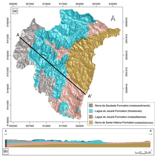
Figure 6.
(a) Three-dimensional geological model from the Vieira River watershed created in Leapfrog Geo from regional data, well construction profiles and geological mapping. The model divided formations from the Bambuí Group: basal Serra de Santa Helena Formation (metasiltstones), metasiltstones and limestone from Lagoa do Jacaré Formation, and last, Serra da Saudade Formation (metasediments). The urban area mainly overlays Serra de Santa Helena Formation. (b) Geological cross section A-A´(NW–SE), with units dipping to the NW, where a special correlation between units can be seen (see Section 2.3).
4.2. Hydrogeology
There are three aquifer systems in the Vieira River watershed, which are granular, karstic fissured aquifers and poor fractured formations (Figure 7). Figure 6b highlights (in blue) the Lagoa do Jacaré Formation, which corresponds to the karstic fissured hydrogeological unit. Other domains of lower transmissivity associated with the metapelitic layers described in the Serra da Santa Helena and Serra da Saudade Formations are also mapped (Figure 6b), and those can locally be classified and behave as an aquitard, but also present the characteristics of a poor aquifer, with production potential higher in calcareous intercalations and contact zones.
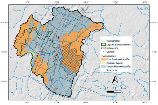
Figure 7.
Lapa Grande State Park including main geological structures, cavities [40] and aquifer systems of Vieira River watershed. The urban zone is located mostly above poor, fractured aquifers from Serra de Santa Helena Formation (see Figure 6a), and granular aquifers are restricted to the west. Most of the area is included in a karstic fissured aquifer, mostly from Lagoa do Jacaré Formation (see Figure 6a). Hydrogeologically, it is also seen that most drainage is on geological structures, with the most prominent being fold-related remarkable faults and fractures in the NNE–SSW direction, and karstic cavities follow the same pattern.
The dominant Lagoa do Jacaré Formation mostly consists of limestone, in which the karstic fissured aquifer is formed [13]. On this geological unit, there is the important local karstic system known as Lapa Grande State Park, where several structures and characteristic features occur, i.e., caves, lakes, swallets and sinkholes (Figure 7). This karstic fissured domain is structurally heterogeneous and consequently spatial permeability varies. Test results gave hydrodynamic parameters [1], showing this high variability, with the storage coefficient in fracture zones varying up to 4000 times, which is expected for the given geological environment. Regarding the hydraulic conductivity of the fractures, it presented low values (average of 0.07 m/day).
Poor fractured aquifers are developed in metasiltstones and metamudstones from the Serra da Santa Helena and Serra da Saudade Formations and are characterized by low hydraulic-transmissivity metapelitic layers. Locally, this type of system resembles a karstic fissured aquifer system with carbonate intercalations and/or with a low thickness, as in the Lagoa do Jacaré Formation. It commonly presents passages in which it behaves as an aquitard, a characteristic also recognized in literature regarding the local and regional settings. The urban Montes Claros zone is in the poor, fractured aquifer, a fact that supports the reason for low groundwater productivity in this area.
According to previous studies [1], the main recharge zone of the basin coincides with the topographical high where the Lagoa do Jacaré Formation limestone emerges, located mainly in the Lapa Grande State Park. Due to differences in the hydraulic gradient and new analyses of the potentiometric surfaces in conjunction with the structural features, a local underground flow is observed in the NW/SE direction, different from the regional SW/NE flow [13]. The analysis of surface waters and their connections with the subsoil also suggests this interpretation locally.
There are already some results and analysis regarding the potentiometric level and specific capacity of local aquifers [13]. The wells show an average of 86 m deep, reaching up to 230 m. The average groundwater level is ca. 14.5 m deep, with a maximum around 60 m. Most of these wells are in limestone and metapelites from the Lagoa do Jacaré and Serra da Santa Helena Formations.
Over 70% of the groundwater wells are in the Montes Claros urban area, and are mostly used for domestic and industrial activities (Figure 8a). In this area, the groundwater is deeper (ca. 600 m) because of geomorphological features and possible dewatering caused by the large concentration of wells there. The specific capacity data (m3/h/m) came mainly from pumping tests carried out during groundwater well abstraction. This urban area is in the metapelitic domain that is related to intercalations of limestone and metasiltstones, which explains the low values of specific capacity (Figure 8b). This lower productivity is mainly associated with the intercalating of metasiltstones and metamudstones from the Lagoa do Jacaré and Serra da Santa Helena Formations, which result in a poor, fractured aquifer. The same geological domain is commonly classified as an aquitard due to his low transmissivity and productivity.
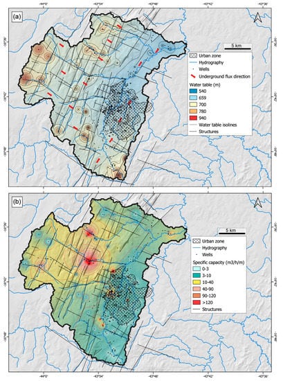
Figure 8.
(a) Groundwater level variation and groundwater flow direction (SW and NE, towards Vieira River). (b) Specific capacity in Vieira River watershed with anomalies observed in the northern karstic area. As mentioned, most wells are located in the urban zone or near structures, and superficial hydrography is controlled by geological structures.
In the urban area, higher water specific capacity zones are related to intersections of NNE–SSW alignments. These are related to regional structures and main orthogonal fractures (WNW–ESE), which are commonly represented by the confluence of watercourses such as the Vieira River and Dos Bois Creek.
In addition to the specific capacity values obtained from SIAGAS wells and interpolated in this work (Figure 8b), other works [41] also present hydrodynamic parameters for lithotypes in northern Minas Gerais, with emphasis on transmissivity ranges in the two main aquifers presented in this work. Transmissivity values (T) vary between 7.17 × 10⁻⁵ m/s2 and 8.74 × 10⁻⁴ m/s2 for karstic fissured aquifers and around 7.50 × 10⁻⁶ m/s2 for poor, fractured aquifers, which in the area would be associated with metasiltstones.
5. Discussion
In Figure 9, it is possible to observe different groundwater level variations from the manual monitoring data collected from fourteen wells in the area. As the main distribution of wells is in the urban area, most wells are in metapelitic regions except for automated well 12 and manual well 9, which were drilled into the limestone of the Lagoa do Jacaré Formation (Figure 4). Well 11 and well 14 are in regions of relevant intercalations of both metapelitic and limestone layers. The other wells are located mainly in the metasiltstones of the Lagoa do Jacaré Formation and Serra da Santa Helena Formation.
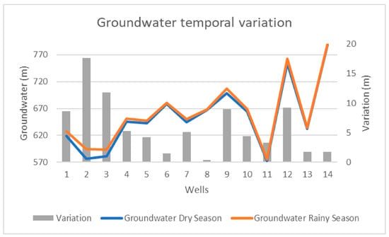
Figure 9.
Temporal groundwater level variation between dry season and rainy season in 14 wells.
From the graph’s secondary axis, it is possible to identify two groups with higher seasonal groundwater variations. The first group is represented by wells 1, 2 and 3, which are in the urban region and within a metapelitic domain. At these wells, there is groundwater oscillation between 8.60 and 17.62 m at the end of the rainy season (March 2022), demonstrating anomalous values compared to the other groups (Figure 9).
It is important to emphasize that well 2 had the highest groundwater level variation (Figure 9) and is in a region with a sequence of industrial wells, where some of them are equipped and pumped according to the companies’ needs. This situation is particularly relevant during the dry season, as it coincides with more restrictions on water distribution, and sometimes with severe rationing.
Groundwater exploitation in an area with a lower specific capacity (Figure 8b) interferes with neighboring wells 1 and 3, and also contributes to the justification of the highest groundwater variation. The other group, with a significant groundwater difference between the dry and rainy periods, is represented by wells 9 and 12 (Figure 9), which are precisely those drilled in the Lagoa do Jacaré Formation limestone, where greater natural oscillation is expected due to the karst domain having very well-developed and connected features.
The main recharge zone of the Vieira River watershed occurs in the karstic environment, having complex connections, high specific capacities (Figure 8b), and abrupt and larger variations when compared to the other monitored wells. Figure 10 shows data obtained every 6 h for automated wells, where it is possible to observe similar behaviors and larger variations in response to rainfall.
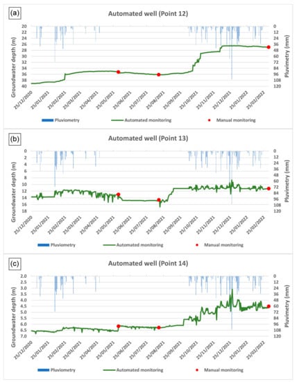
Figure 10.
Automated data for the three wells (points 12 (a), 13 (b) and 14 (c); Figure 4) in the karst domain, where wells 12 and 14 are located north of the studied area and well 13 is near the urban area. There seems to be a trend between point 12 (a) and 14 (c) of decreasing groundwater depth, which is not seen in point 13 (b).
At automated monitoring points in the karst domains, well 12 presented the greatest variation in the water level depth (greater than 10 m; Figure 10) and is directly associated with rainfall, demonstrating an almost immediate elevation of the groundwater level, which is expected for areas that present typical underground connections in this geological environment. The same pattern is not observed in well 14 (Figure 10), mainly because it is closer to the metapelites at the limestone’s base and shows a softer oscillation behavior.
Well 13 presents high negative oscillations (Figure 10) and suggests strong indications of interference caused by the neighboring wells. This point, which has several other wells in the neighborhood, has already been operated in situations of need as confirmed by the area (Viveiros Park) manager. This pattern is very similar to the behavior observed in wells 1, 2 and 3. As seen in Figure 4, these wells are located within the urban area, which presents a large concentration of registered and clandestine wells that have industrial and domestic use. The observed variations at these points (wells 1, 2, 3 and 13) are typical of the pumping interference found in wells that are very close to each other; a situation confirmed in the field and shown in Figure 4, which is very commonly observed in urban areas with low surface water availability and leads to overloading the aquifer.
Automated monitoring was also implemented in the Vieira River spring and downstream (Figure 11). The region is rural and has no urban interference, and therefore does not present external contributions to the watershed, such as sewage. The observed oscillation in point 15 (spring; Figure 4) is clearly related to precipitation, with a reduction of more than 50% in the flow between the dry and rainy periods as a response to the irregular pluviometric frequency in the region. The same response of oscillation due to rainfall is observed for point 16, which is downstream of the Vieira River. However, this monitoring point is located at the end of the entire course of the river in the watershed, which includes all hydrographic contributions, but also urban effluents and sewage. This additional variable is directly correlated with water quantity (scarcity) and severely impacts the water river quality.
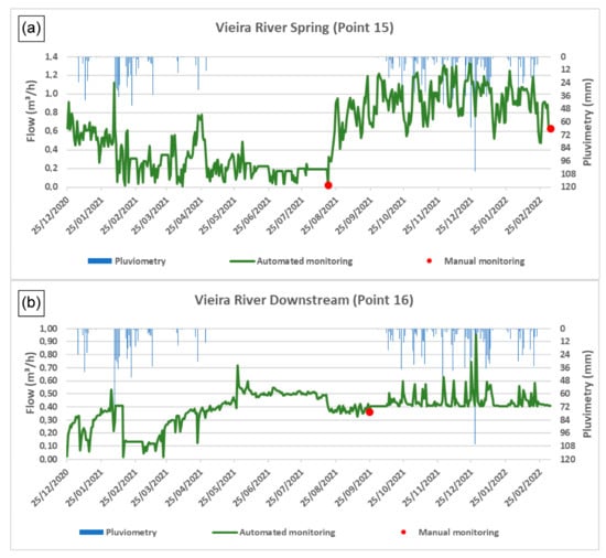
Figure 11.
Automated flow monitoring near Vieira River spring (a) and downstream (b), far from interference from the urban zone. Point 15 corresponds to Vieira River spring (a), while point 16 is downstream (b). The flow change in point 15 can be easily related to pluviometry, while interference at point 16 could be related to tributary rivers and urban zone contributions.
6. Conclusions
In Montes Claros, a semi-arid climate predominates, with an annual average rainfall of less than 1000 mm over the last decade. The irregular rainfall, concentrated between November and February and extending into March in some years, generates a need for groundwater consumption that presents large seasonal variations. As observed in the pluviometric history (Figure 2), there is also great variability in the annual rainfall distribution, which is characteristic of the local climate and impacted by climate change, as evidenced in Brazil, particularly in this semi-arid region.
Based on field work and the well data used to update the 3D geological model (Figure 6), this study characterized two aquifer systems underlying the Vieira River watershed (Figure 7): a karstic fissured aquifer (the Lagoa do Jacaré limestone Formation) and poor, fractured aquifer systems (metapelites from Serra da Santa Helena and Serra da Saudade Formations). Surface and groundwater monitoring by conventional and automated methods (see Figure 9, Figure 10 and Figure 11) proved variations in the watershed and the aquifer system related to (1) hydrogeological domains, (2) oscillations related to interference from neighboring wells, and (3) seasonal variations and irregular pluviometry data in the region. The results suggests characteristic elements of groundwater stress, which are intensified in regions with interference between pumping wells, as seen mainly in the urban region (see Figure 8).
This is very important information for updating local hydrogeological knowledge. Regarding the surface and groundwater flow dynamics, this information can be used to propose new water resource management techniques with the aim of ensuring sustainability in the exploitation of local aquifer systems, especially the karstic aquifer represented by the Lagoa do Jacaré Formation, which is the most important recharge area in the studied region. Future studies should focus on the distinction between the two geological formations, the Serra da Santa Helena and Lagoa do Jacaré Formations, and quantify the number of local wells and their water consumption to intensify monitoring, allowing us to draw conclusions at a higher level of detail. In addition to the three-dimensional (3D) geological model, this information can be used as input for a conceptual hydrogeological model proposed for this area.
Author Contributions
Conceptualization, A.P.B.; methodology, A.P.B.; software, A.P.B. and A.R.N.S.; validation, A.P.B. and I.M.H.R.A.; formal analysis, A.P.B. and R.S.d.P.; investigation, A.P.B.; resources, A.P.B., I.M.H.R.A. and R.S.d.P.; data curation, A.P.B. and R.S.d.P.; writing—original draft preparation, A.P.B.; writing—review and editing, A.P.B., I.M.H.R.A., E.A.G.M., R.S.d.P. and A.R.N.S.; visualization, A.P.B. and I.M.H.R.A.; supervision, A.P.B. and I.M.H.R.A.; project administration, A.P.B. and I.M.H.R.A.; funding acquisition, A.P.B. and I.M.H.R.A. All authors have read and agreed to the published version of the manuscript.
Funding
This work has received no external funding, but is supported and framed within the activities of the FCT: Foundation for Science and Technology, I.P., projects UIDB/04683/2020 and UIDP/04683/2020.
Data Availability Statement
Publicly available datasets were analyzed in this study. These data can be found here: http://siagasweb.cprm.gov.br/layout/ accessed on (1 July 2020). The rest of the presented data is available upon request from the corresponding author; the data are not publicly available due to their large quantity.
Conflicts of Interest
The authors declare no conflict of interest.
References
- Hidrogeologia dos Ambientes Cársticos da Bacia do Rio São Francisco Para a Gestão de Recursos Hídricos, Agência Nacional de Águas (ANA). Available online: https://metadados.snirh.gov.br/geonetwork/srv/por/catalog.search#/metadata/11828587-8176-4eb9-a367-0e4cdf9b2e3d (accessed on 26 April 2023).
- Estudo da Disponibilidade Hídrica Subterrânea do Norte de Minas Gerais, Projeto Águas do Norte de Minas (PANM), Relatório de Integração (2018), Brazilian Geological Survey (CPRM). Available online: https://rigeo.cprm.gov.br/handle/doc/21117 (accessed on 26 April 2023).
- Vieira, E.O.; Sandoval-Solis, S. Water resources sustainability index for a water-stressed basin in Brazil. J. Hydrol. Reg. Stud. 2018, 19, 97–109. [Google Scholar] [CrossRef]
- Plano de Recursos Hídricos da Bacia Hidrográfica do Rio Verde Grande, Agência Nacional de Águas (ANA). Available online: https://cdn.agenciapeixevivo.org.br/media/2020/01/PRH-DA-BACIA-DO-RIO-VERDE-GRANDE.pdf (accessed on 26 April 2023).
- Grafton, R.Q.; Williams, J.; Pittock, J.; Toucher, M.L.W. Global insights into water resources, climate change and governance. Nat. Clim. Chang. 2013, 3, 315–321. [Google Scholar] [CrossRef]
- Mattos, J.B.; Santos, D.A.; Filho, C.A.T.F.; Santos, T.J.; Dos Santos, M.G.; Paula, F.C.F. Water production in a Brazilian montane rainforest: Implications for water resources management. Environ. Sci. Policy 2018, 84, 52–59. [Google Scholar] [CrossRef]
- Acharyya, A. Groundwater, Climate Change and Sustainable Well Being of the Poor: Policy options for South Asia, China and Africa. Procedia Soc. Behav. Sci. 2014, 157, 226–235. [Google Scholar] [CrossRef]
- Selby, J.; Hoffmann, C. Beyond scarcity: Rethinking water, climate change and conflict in the Sudan. Glob. Environ. Chang. 2014, 29, 360–370. [Google Scholar] [CrossRef]
- Ilyushin, Y.V.; Asadulagi, M.A.M. Development of a Distributed Control System for the Hydrodynamic Processes of Aquifers, Taking into Account Stochastic Disturbing Factors. Water 2023, 15, 770. [Google Scholar] [CrossRef]
- Krol, M.S.; Bronstert, A. Regional integrated modelling of climate change impacts on natural resources and resource usage in semi-arid Northeast Brazil. Environ. Model. Softw. 2007, 22, 259–268. [Google Scholar] [CrossRef]
- Montenegro, S.; Ragab, R. Impact of a possible climate and land use changes in the semi-arid regions: A case study from North Eastern Brazil. J. Hydrol. 2012, 434, 55–68. [Google Scholar] [CrossRef]
- Herrera-Pantoja, M.; Hiscock, K.M. Projected impacts of climate change on water availability indicators in a semi-arid region of central Mexico. Environ. Sci. Policy 2015, 54, 81–89. [Google Scholar] [CrossRef]
- Bhering, A.P.; Antunes, I.M.H.R.; Marques, E.A.G.; Paula, R.S. Geological and Hydrogeological review of a semi-arid region with conflicts to water availability (Southeastern Brazil). Environ. Res. 2021, 202, 111756. [Google Scholar] [CrossRef]
- Bakalowicz, M. Karst groundwater: A challenge for new resources. Hydrogeol. J. 2005, 13, 148–160. [Google Scholar] [CrossRef]
- Goldscheider, N.; Drew, D. Methods in Karst Hydrogeology; Taylor and Francis Group: London, UK, 2007; 264p. [Google Scholar]
- Krol, M.; Jaeger, A.; Bronstert, A.; Güntner, A. Integrated modelling of climate, water, soil, agricultural and socio-economic processes: A general introduction of the methodology and some exemplary results from the semi-arid north-east of Brazil. J. Hydrol. 2006, 328, 417–431. [Google Scholar] [CrossRef]
- Braga, L.T.P.; Velásquez, L.N.M.; Fleming, P.M.; Rodrigues, P.C.H.; Da Silva, S.M. Investigação da recarga do tipo localizada nos aquíferos cársticos do Grupo Bambuí em região semi-árida, norte de MG. In Proceedings of the XVI Congresso Brasileiro de Águas Subterrâneas, São Luis, Brazil, 3 September 2010. [Google Scholar]
- Karmann, I. Evolução e Dinâmica Atual do Sistema Cárstico do Alto Vale do Rio Ribeira de Iguape, Sudeste do Estado de São Paulo. Ph.D. Thesis, Universidade de São Paulo, São Paulo, Brazil, 1994. [Google Scholar]
- Auler, A.S. Karst Evolution and Palaeoclimate of Eastern Brazil. Ph.D. Thesis, University of Bristol, Bristol, UK, 1999. [Google Scholar]
- Pessoa, P.F.P. Hidrogeologia dos Aquíferos Cobertos de Lagoa Santa, MG. Ph.D. Thesis, Universidade Federal de Minas Gerais, Belo Horizonte, Brazil, 2005. [Google Scholar]
- Paula, R.S.; Velásquez, L.N.M. Modelagem numérica de fluxo de um aquífero cárstico-fissural. Águas Subterrâneas 2013, 27, 66–78. [Google Scholar] [CrossRef]
- Soares, L.C.; Velásquez, L.N.M. Estimativa da recarga aquífera na Bacia do Rio Riachão, norte de Minas Gerais. Águas Subterrâneas 2013, 27, 104–120. [Google Scholar] [CrossRef]
- Ninanya, H.; Guiguer, N.; Vargas, E.A., Jr.; Nascimento, G.; Araujo, E.; Cazarin, C.L. Analysis of water control in an underground mine under strong karst media influence (Vazante mine, Brazil). Hydrogeol. J. 2018, 26, 2257–2282. [Google Scholar] [CrossRef]
- Paula, R.S. Modelo Conceitual de Fluxo dos Aquíferos Pelíticos-Carbonáticos da Região da APA Carste de Lagoa Santa, MG. Ph.D. Thesis, Universidade Federal de Minas Gerais, Belo Horizonte, Brazil, 2019. [Google Scholar]
- Delimitation of the Semi-Arid, Superintendência de Desenvolvimento do Nordeste (SUDENE). Available online: http://www.sudene.gov.br/delimitacao-do-semiarido (accessed on 31 January 2020).
- Leite, M.E. Geoprocessamento Aplicado ao Estudo do Espaço Urbano: O Caso da Cidade de Montes Claros/MG. Master’s Thesis, Universidade Federal de Uberlândia, Uberlândia, Brazil, 2006. [Google Scholar]
- Leite, M.E.; Santos, I.S.; Almeida, J.W.L. Mudança de Uso do Solo na Bacia do Rio Vieira, em Montes Claros/MG. Rev. Bras. Geogr. Física 2011, 4, 779–792. [Google Scholar] [CrossRef]
- Station Data, Instituto Nacional de Metereologia (INMET). Available online: https://tempo.inmet.gov.br/ (accessed on 2 February 2022).
- Pluviometric Atlas of Brazil (2013), Brazilian Geological Survey (CPRM). Available online: http://www.cprm.gov.br/publique/Hidrologia/Mapas-e-Publicacoes/Atlas-Pluviometrico-do-Brasil-1351.html (accessed on 13 May 2020).
- Almeida, F.F.M. O Cráton do São Francisco. Rev. Bras. Geociências 1977, 7, 349–364. [Google Scholar]
- Alkmim, F.F.; Martins-Neto, M.A. Proterozoic first-order sedimentary sequences of the São Francisco craton, eastern Brazil. Mar. Pet. Geol. 2012, 33, 127–139. [Google Scholar] [CrossRef]
- Caxito, F.A.; Frei, R.; Uhlein, G.J.; Dias, T.G.; Árting, T.B.; Uhlein, A. Multiproxy geochemical and isotope stratigraphy records of a Neoproterozoic Oxygenation Event in the Ediacaran Sete Lagoas cap carbonate, Bambuí Group, Brazil. Chem. Geol. 2018, 481, 119–132. [Google Scholar] [CrossRef]
- Martins-Neto, M.A.; Pedrosa-Soares, A.C.; Lima, S.A.A. Tectono-sedimentary evolution of sedimentary basins from Late Paleoproterozoic to Late Neoproterozoic in the São Francisco craton and Araçuaí fold belt, eastern Brazil. Sediment. Geol. 2001, 141, 343–370. [Google Scholar] [CrossRef]
- Dardenne, M.A. Síntese sobre a estratigrafia do Grupo Bambuí no Brasil Central. In Proceedings of the 30th Congresso Brasileiro de Geologia, Recife, Brazil, November 1978. [Google Scholar]
- Projeto Norte de Minas. Available online: http://www.portalgeologia.com.br/index.php/mapa/ (accessed on 27 April 2023).
- Geologia e Recursos Minerais da Folha Montes Claros, SE.23-X-A-VI: Estado de Minas Gerais, Brazilian Geological Survey (CPRM). Available online: https://rigeo.cprm.gov.br/handle/doc/18279 (accessed on 27 April 2023).
- Chaves, M.L.D.S.; Andrade, K.W.; Benitez, L. Geologia integrada das Folhas Jequitaí, Bocaiúva e Montes Claros (1:100.000), norte de Minas Gerais. Geonomos 2011, 19, 1–7. [Google Scholar] [CrossRef]
- TOPODATA—Banco de Dados Geomorfométricos do Brasil, Instituto Nacional de Pesquisas Espaciais (INPE). Available online: http://www.dsr.inpe.br/topodata/ (accessed on 5 May 2023).
- SIAGAS—Sistema de Informações de Águas Subterrâneas, Brazilian Geological Survey (CPRM). Available online: http://siagasweb.cprm.gov.br/layout/ (accessed on 1 July 2020).
- CANIE—Cadastro Nacional de Informações Espeleológicas, Centro Nacional de Pesquisa e Conservação de Cavernas, (CECAV). Available online: http://www.icmbio.gov.br/cecav/canie.html (accessed on 31 January 2020).
- Águas do Norte de Minas, PANM: Estudo da Disponibilidade Hídrica Subterrânea do Norte de Minas Gerais: Relatório de Integração, Brazilian Geological Survey (CPRM). Available online: https://rigeo.cprm.gov.br/jspui/handle/doc/21117 (accessed on 26 May 2023).
Disclaimer/Publisher’s Note: The statements, opinions and data contained in all publications are solely those of the individual author(s) and contributor(s) and not of MDPI and/or the editor(s). MDPI and/or the editor(s) disclaim responsibility for any injury to people or property resulting from any ideas, methods, instructions or products referred to in the content. |
© 2023 by the authors. Licensee MDPI, Basel, Switzerland. This article is an open access article distributed under the terms and conditions of the Creative Commons Attribution (CC BY) license (https://creativecommons.org/licenses/by/4.0/).