Abstract
Land suitability assessment for irrigation is critical to inform as well as manage current and future irrigated agriculture production systems. Land suitability analysis determines whether a given land area could potentially be used for specific crop production. The objective of this study was to identify the availability of suitable land for surface irrigation systems for the production of millet, sorghum, sugarcane, and wheat production in the Lower Omo Gibe plain, Southern Ethiopia. Land suitability analysis was performed by a parametric method using factors such as soil texture, effective soil depth, Calcium Carbonate (CaCO3), soil electrical conductivity (ECe), drainage class, and slope. Five land suitability classes were identified that include highly suitable (S1), moderately suitable (S2), marginally suitable (S3), currently not suitable (N1), and permanently not suitable (N2). Results showed that 6.6, 7.5, 6.6, and 6.6% of the study area mostly located in the western part of the basin, were highly suitable (S1) for irrigated millets, sorghum, sugarcane, and wheat crops production, respectively. However, the mountainous areas in the central part of the basin were classified as N2 due to the steep slope and shallow soil depth. Overall, the results of the study revealed that the use of various suitability analysis techniques could assist in identifying suitable land for irrigated agriculture.
1. Introduction
The concept of land evaluation refers to predicting the performance of land over time by considering the type of land use, as defined by Van Diepen [1] and Rossiter [2]. The strategic land-use decisions are then based on these predictions. Therefore, soil surveys are the primary basis for evaluating land. According to the Food and Agricultural Organization (FAO), suitability is based on crop requirements and land characteristics, measuring how well the characteristics of a land unit match the demands of a particular land use [3]. A land suitability assessment is therefore a prerequisite to assessing agricultural production sustainably. Ethiopia has the second-largest population after Nigeria in Africa, and 79.6% of its people live in rural areas and rely primarily on low-productivity agriculture [4]. There are abundant water resources in Ethiopia; it receives about 980 billion m3 of rainwater each year [5,6]. According to Awulachew [7], 30 to 70 million ha of land could be cultivated. Awulachew [5] estimated Ethiopia’s potential irrigable land to be 5.3 million ha, which includes 1.65 million ha that could be irrigated using groundwater or rainwater.
A parametric approach is proposed for identifying the suitability of land for irrigation and crop production based on soil physical and chemical parameters [8]. The soil properties and topography of a piece of land determine its suitability for irrigation. Researchers have used parametric systems to evaluate land suitability for surface, sprinkler, and drip irrigation, as well as for different crops in different watersheds. Lanfredi and Ronchi [9] used a parametric methodology similar to [8] for examining the suitability of land for rain-fed agriculture in Kilte Awlaelo, Tigray, Ethiopia. Based on the literature and the opinions of experts, factors that affect irrigation land suitability for surface irrigation have been identified. The climatic requirements of the selected crops, such as precipitation, mean temperature, and relative humidity during the growing cycle, are some of several factors to be taken into account [8,10,11]. Land characteristics include physical soil characteristics including texture, course fragment, soil depth, CaCO3, gypsum, and soil fertility features like apparent ECE, base saturation, sum of basic cations, PH, organic carbon, as well as salinity and alkalinity. Factors that affect the suitability of an area for surface irrigation were identified and used for this study. These factors are important for the growth and development of crops and farm management. Landform variables such as soil depth, slope, drainage class texture, calcium carbonate (CaCO3), electrical conductivity (EC), and pH were used to generate a map describing the suitability of land to irrigate crops such as barley, teff, millet, sorghum, wheat, maize, peas, beans, chickpeas, and groundnuts. A parametric land evaluation approach was used by Gebremariam and Zhang [12] to evaluate rain-fed crop production in Tigray, Ethiopia. According to the study, topographic constraints mainly affect the suitability of land for cultivation. Their study area had moderate to steep slopes and escarpments as well as shallow soils that were unsuitable for retaining moisture. A study by Mahari and Alebachew [13] evaluated the suitability of soil properties in the Bicheat watershed of Dejen district, Ethiopia, for irrigation. Parametric methods were used to evaluate soil properties such as texture, depth, EC, drainage, CaCO3 content, and slope of the study area. A steep slope, gravelly soil texture, and shallow depth of soil made 120 ha of land permanently unsuitable.
Albaji and Alboshokeh [14] carried out a land suitability evaluation study in the Fakkeh region, southwest Iran, for key crops such as wheat, alfalfa, maize, and barley, covering 43,700 ha was undertaken by using a parametric method. In their investigation, a physical property of the soil, especially light soil texture, was the most significant limiting factor in the production of wheat, alfalfa, and barley. Similarly, In Fars province in southern Iran, Azadi and Baghernejad [15] used a parametric approach to evaluate land suitability for wheat and sugar beet cultivation in 15,000 ha of land. Due to relative humidity limitations caused by the growing cycle, their study showed that the area is moderately suitable for wheat and highly suitable for sugar beet. They suggested a modification of climatic suitability since the mean temperature during the growth cycle is the main limiting factor for irrigated wheat. Mathewos et al. [16] evaluated the land suitability of Bilate Alaba sub-watershed for maize, sorghum, and wheat production under rainfed conditions. A maximum limitation and parametric methods were used to determine land suitability categories. An approach for evaluating the suitability of a watershed for surface irrigation was used by Weldeabzgi et al. [17]. As a result of the land suitability evaluation, a total area of 3064 ha (72.6%) was marginally suitable, while 1154 ha (27.4%) were currently unsuitable. In addition to land suitability for crop cultivation analysis, many researchers have applied a parametric land evaluation approach to different irrigation methods for their area of interest [18,19,20,21,22,23,24].
A large irrigation command area in the southern part of Ethiopia, the lower Omo Gibe basin is under development for sugarcane production to supply the sugar factories. The government also plans to irrigate the area with wheat. Therefore, it was essential to evaluate the suitability of the land for major crops in this region. The major grains, maize, wheat, and sorghum have long contributed to food security in Ethiopia [25] and mostly grown in the highland parts of the country [26]. In order to inform future land allocation and development planning in the lower Omo Gibe basin, southern Ethiopia, this study evaluated and compared land suitability for surface irrigation-based production of millet, sorghum, sugarcane, and wheat. A combination of geographical information system (GIS) and parametric methods was used.
2. Materials and Methods
2.1. Description of the Study Area
The study was carried out in the lower Omo Gibe basin in southern Ethiopia. The basin is located between latitude 5°17′12″ to 6°24′15″ N and longitude 35°37′15″ to 36°4′30″ E. The area of the watershed is 2530 km2, and elevations range between 368 and 807 m a.m.s.l (Figure 1). According to rainfall data collected from the meteorological stations within the study area, the basin receives on average 972 mm per year of rainfall, with deficient rainfall in months of December to February. The average minimum and maximum monthly temperatures in the study area were 18.8 °C and 35.5 °C, respectively. The annual mean temperature of the watershed is 26.8 °C (Figure 2).
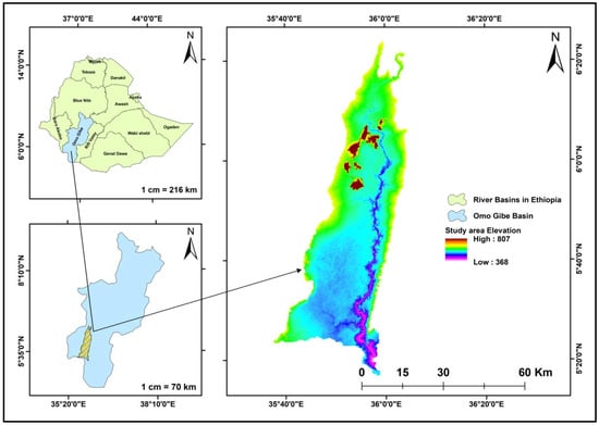
Figure 1.
Location of the study area in relation to river basins in Ethiopia and the Omo-Gibe basin.
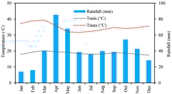
Figure 2.
Monthly mean minimum and maximum temperatures, as well as monthly mean rainfall records, are based on observations from 1981 to 2020.
The study area is characterized mainly by gentle land features. The major soil types of the study area are Chromic Luvisols, Eutric Leptosols, Eutric Fluvisols, Eutric Vertisols, Lithic Leptosols, Sodic Solonchaks, and Petric Gypsisols. The major land uses of the watershed are forest land (57.7%), cropland (16.9%), shrub land (15.5%), grassland (7.6%), and the remaining (2.3%) of land is covered with water bodies, flooded vegetation, built-up area, and bare land (Figure 3).
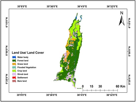
Figure 3.
Land use/land cover types of the study area.
Surface irrigation is widely practiced in the study area. A surface irrigation system has been constructed along the Omo and Sharman rivers to meet the crop water needs during the summer and winter seasons by constructing headwork structure across the rivers. A large portion of this area is irrigated for sugarcane cultivation. In addition to wheat, sorghum, millets, barley, and maize, irrigation is planned for these crops.
2.2. Data Collection and Analysis
The study used soil data from Ethiopia’s Ministry of Water and Energy, the harmonized world soil database (HWSD) v1.2, and a digital elevation model with a spatial resolution of 12.5 m obtained from https://search.asf.alaska.edu/ accessed on 10 June 2022 for slope analysis. The land use/land cover map was downloaded from https://livingatlas.arcgis.com/landcover/ accessed on 5 June 2022 and had a 10 m resolution.
Analysis was conducted for each physical land suitability factor to evaluate the suitability of the suggested land for surface irrigation after the necessary data had been gathered from different sources. The major land suitability analysis factors considered for irrigation-based crop production in this study were slope, drainage properties, texture, effective soil depth, CaCO3 status, and EC. A weighted assessment of each factor was conducted to identify suitable areas for surface irrigation. Data analysis was done in Microsoft Excel 2019 (Microsoft Office, Redmond, WA, USA) based on the rating scale of topographic and soil requirements for the selected crops [8].
2.3. Suitability Assessment Method
To determine land suitability classes, the FAO method recommends the parametric method procedure stated by Sys et al. [8] was used based on selected crop requirements and measured landscape and soil parameters (Table 1). A soil’s capacity to retain water is strongly influenced by its capacity to drain, the amount of organic carbon present, and the texture of the soil [27]. Based on their ability to retain water, four different types of soil textures were identified: very high holding capacity (silt, silt loam, and silty clay loam), high holding capacity (silty clay and clay), low holding capacity (loamy sands), and very low holding capacity (e.g., sands). The hydraulic conductivity of the soil is influenced by a variety of factors. According to Benson and Daniel [28], the soil composition, permeant properties, void ratio, structure, and degree of saturation during permeation were the five variables that had the most influence on hydraulic conductivity. Several land characteristics were combined in this model, including physical and chemical soil characteristics (texture, depth, CaCO3, pH, and EC), topography (slope), and wetness characteristics (drainage) to identify land suitability. Based on the workflow shown in Figure 4, land suitability maps were created for the 21 soil mapping units using ArcGIS 10.3.1.

Table 1.
Topographic and soil requirements—Wheat, sugarcane, sorghum, and millets [8].
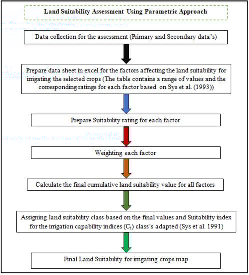
Figure 4.
Flow chart of parametric approach for assessing land suitability for irrigating crops.
Soil and topographic factors are considered on a numerical scale ranging from 0 to 100%, attributes having certain limitation gets a low rate up, and a high rate is assigned to the most appropriate attribute, which corresponds to a suitability rating based on a parametric evaluation method. The Storie method provides this index as a multiplicative of each characteristic [29], and it is mathematically expressed in (Equation (1)) as follows:
where: Ci represents the irrigation suitability index, A represents the soil texture rating, B represents the soil depth rating, C represents the CaCO3 status rating, D represents the electro conductivity rating, E represents the drainage rating, and F represents the slope rating. The value of the capability index is used to determine suitability categories (Table 2).
Table 2.
Suitability index for the irrigation capability indices (Ci) classes [30].
3. Results and Discussion
3.1. Suitability of Thematic Maps
The land suitability maps for different crops were prepared based on a parametric approach using a digital soil map. The topography and soil characteristics of the study area allowed the detection of 21 soil series. Table 3 shows topographic characteristics such as slope and soil properties such as soil texture, effective soil depth, salinity, drainage, and calcium carbonate content (Figure 5).
Table 3.
The study area’s soil physicochemical parameters.
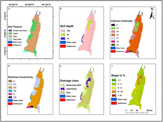
Figure 5.
Topography and soil physical and chemical properties of the study area: (a) Soil texture, (b) Soil Depth (cm), (c) Calcium Carbonate (CaCO3) (%), (d) Electrical Conductivity (dS m−1), (e) Drainage class, and (f) Slope (%).
3.1.1. Soil Physical Properties
Clay is the dominant textural class in the basin, covering 71.2% of the land area. A clay soil texture is highly suitable for wheat, sugarcane, sorghum, and millet production according to Sys et al. [8] landscape and soil requirements guideline, followed by 24.9, 3.3, and 0.52% of loam, clay loam, and sandy clay loam, respectively (Figure 5a). The soil texture influences soil pore spaces, as well as the soil permeability and infiltration rate, which are important factors in soil physical analysis for surface irrigation suitability evaluation [31].
In the study area, soil depth varies from 10 to 100 cm (Figure 5b). as per African Geological map data base Quaternary sediments, Tertiary extrusive and intrusive rock, and Tertiary are the geological features of the study area below the topsoil depth, with respective area coverage of 2162.1 km2, 275.8 km2, and 91.7 km2. Moreover, soil depth plays a significant role in determining whether a farm is suitable for surface irrigation. Surface irrigation is beneficial for deep soils since they have an impact on crop rooting depth. With soil depths of 100 cm, Eutric Fluvisols, Petric Gypsisols, Chromic Luvisols, Sodic Solonchaks, and Eutric Vertisols occur in the study area. On the other hand, Eutric Leptosols and Lithic Leptosols were located 30 and 10 cm below the surface, respectively. As shown in Table 3, the soil drainage in the basin was classified as moderately well-drained, poorly drained, and imperfectly drained (Figure 5e). For evaluating surface irrigation suitability, soil drainage is also an influential factor because it handles excess water on the surface. Without this continuous leaching, salt may build up to levels that may be harmful to the landscape and crops. Proper drainage of a specific area is essential to allow the continuous movement of water and salt through the profile [32].
3.1.2. Soil Chemical Properties
According to Figure 5d, salinity values ranged from 0 to 6 Ds m−1 in the study area which shows highly suitable for sorghum, moderate suitable for sugarcane and millets, and marginal suitable for wheat (Table 1). Average soil calcium carbonate (CaCO3) values ranged from 0 to 4.8%. The highest CaCO3 value of 4.8% was observed in land series coded 14, 15, and 16, and the lowest 0% was recorded in land series coded 12 and 13 (Figure 5c). Despite the fact that calcium carbonate (CaCO3) levels vary across the study area, the range is considered highly suitable for all selected crops.
3.1.3. Slope Evaluation for Growing Field Crops
There are three types of land management methods at the farm level: (1) irrigated agriculture, (2) full mechanization, and (3) low management. By producing a slope suitability map for the full mechanization category in this study, topographic suitability for the cultivation of the selected crops was determined. As shown in (Figure 5f), the slope map was divided into five classes based on the topographic requirement for mechanized surface irrigation as flat (0–2%), gently sloping (2–4%), moderately steep (4–8%), steep (8–16%), and very steep (>16%). Accordingly, the entire watershed has been classified as flat (Land series coded—1, 5, 7, 10, 12, 14, and 17), gentle (Land series coded—2, 15, and 18), moderately steep (Land series coded—3, 6, 8, 11, 13, 16, and 19), steep (Land series coded—4, and 20), and very steep (Land series coded—9, and 21). Thus, surface irrigation is effective in 22.7% of the watershed due to flat and gentle slopes. The slope of a land surface describes its steepness, and it is an influential characteristic of terrain. The slope plays a significant role in plants’ growth, according to Mohammad et al. [33]. Thus, topography directly affects runoff response and soil infiltration rates. Further, they found that a higher slope reduces rainwater infiltration and recharges groundwater by letting more water flow through the topsoil.
3.1.4. Soil Suitability Evaluation for Growing Field Crops
Table 4, Table 5 and Table 6 show the results of a land suitability analysis for surface irrigation using the parametric evaluation method. The selected crops have a high potential for production under irrigation as long as the irrigation water requirements are met. In total, 6.6, 6.6, 7.5, and 6.6% of the study area are highly suitable (S1) for growing wheat, sugarcane, sorghum, and millets. The moderately suitable regions cover a comparatively higher percentage of wheat, sugarcane, sorghum, and millets than highly suitable regions, with 9.2, 9.7, 10, and 11.3%, respectively. There are 42.5, 68.7, 41.5, and 41.1% of the total studied area that are marginally suitable for growing irrigated wheat, sugarcane, sorghum, and millets, respectively. Furthermore, 35.2, 7.8, 35.5, and 35.5% of the study area are currently unsuitable for irrigating wheat, sugarcane, sorghum, and millets, respectively. Approximately 4.4, 5.0, 3.4, and 3.4% of the total land area is permanently unsuitable for wheat, sugarcane, sorghum, and millets.
Table 4.
The Ci values and suitability classes of surface irrigation for each land series using the parametric land suitability analysis method [29].
Table 5.
Suitability for surface irrigation of wheat, sugarcane, sorghum, and millets distribution.
Table 6.
The land series corresponding to crop and suitability class for a different composition.
3.2. Land Suitability for Crops
As shown in Figure 6 and Table 5, land series coded 1, 2, 5, and 12 (167.1 km2, 6.6%) have high suitability for all studied crops, while land series coded 14 and 15 (21.83 km2, 0.9%) are highly suitable for only sorghum. Land series coded 3, 6, and 13 (214.5 km2, 8.5%) show moderate suitability for all studied crops (wheat, sugarcane, sorghum, and millets), and land series coded 14, and 15 (21.8 km2, 0.86%) indicate moderate suitability for sugarcane only. Land series 8 (53.8 km2, 2.13%) exhibits moderate suitability for millets only. Land series coded 3, 6, 13, and 16 (235.9 km2, 9.3%) exhibit moderate suitability for sugarcane and sorghum. Land series coded 3, 6, 7, and 13 (241.5 km2, 9.5%) show moderate suitability for wheat, sorghum, and millets.
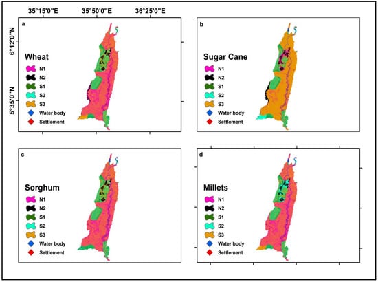
Figure 6.
Land suitability map classes for (a) Wheat, (b) Sugarcane, (c) Sorghum, and, (d) Millets.
Land series coded 4, 17, and 18 (1009.4 km2, 39.9%) show marginal suitability for all crops, Series coded 7 and 19 (760.6 km2, 30.1%) show marginal suitability for sugarcane only, and Land series coded 4, 8, 17, and 18 (1063.3 km2, 42.2%) show marginal suitability for wheat and sorghum. Land series coded 4, 14, 16, 17, and 18 covering (1041.9 km2, 41.2%) are marginally suitable for wheat and millets. Similarly, land series coded 4, 10, 17, and 18 (1026.9 km2, 40.6%) demonstrate marginal suitability for sorghum and millets. Land series coded 20 (153.2 km2, 6.1%) exhibits low suitability (not suitable for all crops currently). Land series coded 10 (17.6 km2, 0.7%) exhibits low suitability (currently unsuitable) for wheat only. Land in series coded 8 (53.8 km2, 2.1%) shows low suitability (currently unsuitable) only for sugarcane. In addition, land series coded 11, 19, and 20, which cover (909.9 km2, 35.9%), exhibit low suitability (currently not suitable) for sorghum and millets, and Land series coded 19 and 20 (886.8 km2, 35.1%) exhibit low suitability (currently not suitable) for wheat, sorghum, and millets. Finally, land series coded 9 and 21 (86.9 km2, 3.4%) are permanently unsuitable for all crops (Figure 7). Land series coded 10 (17.6 km2, 0.7%) is permanently unsuitable for all crops, and land series coded 9, 11, and 21 (110.0 km2, 4.4%) are permanently unsuitable for wheat and sugarcane (Table 5 and Table 6).
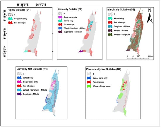
Figure 7.
The land series codes corresponding to crop and suitability class.
The scientific approach to evaluating land suitability can play an indispensable role in boosting irrigated cropland and crop production for a specific area by considering different influencing factors [34]. This research will be useful in evaluating and assessing the potential crop yield of the study area and soil and climate degradation of cultivated lands in the lower Omo basin in southern Ethiopia. Integrated, the parametric method with a GIS environment has been widely used to assess land suitability [14,15,16,17]. Furthermore, El-Aziz [35] determined that a parametric approach was used to determine the suitability of specific areas for a wide range of crops by evaluating the actual soil parameters.
4. Conclusions
Land suitability evaluation is vital for the sustainable development of the regions with effective management and utilization of the land resource. Accurate assessment methods give better results and allow for the establishment of improved management plans. Based on a parametric land suitability evaluation system, this study evaluated the suitability of surface irrigation-based production of millet, sorghum, sugarcane, and wheat on a 2530 km2 area of land in the lower Omo Gibe basin in Southern Ethiopia. Soil texture, effective soil depth, Calcium carbonate (CaCO3), the electrical conductivity of soil solution (ECE), drainage, and slope were recognized as factors affecting land suitability for production of the selected crops in the study area.
Due to steep slopes and shallow soil depth, sorghum and millets are classified as permanently unsuitable in land series 9 and 11. Poor soil drainage and steep slopes affect land series 19, 20, and 21 in the studied area. These land series are also designated as permanently unsuitable for wheat cultivation. The study results showed that land series coded 1, 2, 5, and 12 (167.1 km2, 6.6%) have high suitability for all studied crops, and land series coded 14 and 15 (21.83 km2, 0.9%) are highly suitable for only sorghum. The land series coded 9 and 21 (86.9 km2, 3.4%) are permanently unsuitable for all studied crops. And land series coded 10 (17.6 km2, 0.7%) is permanently unsuitable for all crops, in addition to land series coded 9, 11 and 21 (110.0 km2, 4.4%) are permanently unsuitable for wheat and sugarcane.
Many options can be raised for the sustainable use of the land for crop production in the study area. Most importantly identification of the suitable land for specific crop will increase the agricultural productivity. For illustration, irrigating the crops in their specific suitable land series; amending some of the limiting factors such as pH through the application of fertilizers can lower the alkalinity effect in the soil (e.g., In land series coded 14, 15, and 16 in case of cultivating wheat); application of soil and water conservation measures to increase soil depth (e.g., Land series coded 7, 8, 9, 10 and 11 in case of cultivating sugarcane); and changing the land use type (e.g., land series coded 4, 9, 20 and 21 in case of cultivating sorghum) to other use types such as forest land because these land ‘series’ are located in such a steep area not suitable to irrigate. The study gives an insight into which type of crop included in this study (i.e., millet, sorghum, sugarcane, and wheat) is more feasible in which part of the basin and thus enhances decision-making processes. The use of geospatial data and techniques can be applied for increasing agricultural productivity by selecting a suitable crop for each land category.
Author Contributions
Conceptualization, Y.G.H., T.G.A. and M.Y.; methodology, Y.G.H., T.G.A., M.Y. and M.A.M.; software, Y.G.H., T.G.A. and M.A.M.; validation, Y.G.H., T.G.A., M.Y., D.A.M. and M.A.M.; formal analysis, Y.G.H. and T.G.A.; investigation, Y.G.H.; resources, Y.G.H. and T.G.A.; data curation, Y.G.H. and T.G.A.; writing—original draft preparation, Y.G.H.; writing—review and editing, T.G.A., M.Y., A.M.M., F.T.T., H.K.B., E.A.K., E.A.D., A.B.M. and M.A.M.; visualization, Y.G.H., T.G.A., M.Y. and F.T.T.; supervision, T.G.A., F.T.T. and M.Y. All authors have read and agreed to the published version of the manuscript.
Funding
This research received no external funding.
Data Availability Statement
The data that support the findings of this study are available at the corresponding author upon reasonable request.
Conflicts of Interest
The authors declare no conflict of interest.
References
- Van Diepen, C.A.; Van Keulen, H.; Wolf, J.; Berkhout, J.A.A. Land evaluation: From intuition to quantification. In Advances in Soil Science; Stewart, B.A., Ed.; Springer: New York, NY, USA, 1991; pp. 139–204. [Google Scholar]
- Rossiter, D.G. A theoretical framework for land evaluation (with discussion). Geoderma 1996, 72, 165–202. [Google Scholar] [CrossRef]
- FAO. A Framework for Land Evaluation: Soils Bulletin: 32; Food and Agriculture Organization of the United Nations: Rome, Italy, 1976. [Google Scholar]
- World Population Prospects—Population Division. United Nations Department of Economic and Social Affairs, Population Division. Available online: https://www.un.org/development/desa/pd/.un.org (accessed on 9 November 2019).
- Kassa, M.; Andualem, T.G. Review of Irrigation Practice in Ethiopia, Lessons from Israel. Irrig. Drain. Syst. Eng. 2020, 9, 1. [Google Scholar]
- Andualem, T.G.; Kassa, M.; Getachew Demeke, G.; Hewa, G.; Dar, I.A.; Pham, Q.B.; Yamada, T.J. Grand Ethiopian Renaissance Dam and hydrologic hegemony over Abbay Basin. Sustain. Water Resour. Manag. 2021, 7, 102. [Google Scholar] [CrossRef]
- Awulachew, S.B. Irrigation Potential in Ethiopia: Constraints and Opportunities for Enhancing the System; International Water Management Institute: Colombo, Sri Lanka, 2010. [Google Scholar]
- Sys, I.C.; Van Ranst, B.; Debaveye, J.; Beernaert, F. Land Evaluation; Part III, Crop Requirements, Agricultural Publication No. 7; General Administration for Development Cooperation: Brussels, Belgium, 1993. [Google Scholar]
- Lanfredi Sofia, C.; Ronchi, M. Land Evaluation in Kilte Awulaelo—Tigray Region, Ethiopia. In 29th Course Professional Master. Geomatics and Natural Resources Evaluation; IAO: Florence, Italy, 2009; Available online: http://www.iao.florence.it/training/geomatics/KilteAwulaelo/Ethiopia_29.pdf (accessed on 6 May 2022).
- Worqlul, A.W.; Collick, A.S.; Rossiter, D.G.; Langan, S.; Steenhuis, T.S. Assessment of surface water irrigation potential in the Ethiopian highlands: The Lake Tana Basin. Catena 2015, 129, 76–85. [Google Scholar] [CrossRef]
- Worqlul, A.W.; Jeong, J.; Dile, Y.T.; Osorio, J.; Schmitter, P.; Gerik, T.; Srinivasan, R.; Clark, N. Assessing potential land suitable for surface irrigation using groundwater in Ethiopia. Appl. Geogr. 2017, 85, 1–13. [Google Scholar] [CrossRef]
- Gebremariam, M.A.; Zhang, J. Land evaluation in the Enderta District—Tigray, Ethiopia. In 28th Course Professional Master, Inclusive; IAO: Florence, Italy, 2008; Available online: http://www.iao.florence.it/training/geomatics/EndertaDistrict/Ethiopia_28.pdf (accessed on 5 May 2022).
- Mahari, A.; Alebachew, A.; Markos, D. Land Suitability Evaluation for Irrigation in Dejen District, Ethiopia. Int. J. Sci. Res. Publ. 2013, 3, 1–3. [Google Scholar]
- Albaji, M.; Ibrahim, A. Assessing agricultural land suitability in the Fakkeh region, Iran. Outlook Agric. 2017, 46, 57–65. [Google Scholar] [CrossRef]
- Azadi, A.; Baghernejad, M. Qualitative land suitability assessment and estimating land production potential for main irrigated crops in northern of Fars province. Agric. For. 2018, 64, 263–276. [Google Scholar] [CrossRef]
- Mathewos, M.; Dananto, M.; Erkossa, T.; Mulugeta, G. Parametric Land Suitability Assessment for Rainfed Agriculture: The Case of Bilate Alaba Sub-watershed, Southern Ethiopia. Agrotechnology 2018, 7, 183. [Google Scholar] [CrossRef]
- Weldeabzgi, G.G.; Ketema, T.; Gashu, G.; Deressa, S. Land suitability evaluation for surface irrigation development using parametric evaluation approach: The case of Gudina Wacho watershed, Western Ethiopia. Int. J. Agric. Sci. Food Technol. 2021, 7, 302–309. [Google Scholar]
- Dengize, O. A Comparison of different irrigation methods based on the parametric evaluation approach. Turk. J. Agric. For. 2006, 30, 21–29. [Google Scholar]
- Albaji, M.; Landi, A.; Boroomand Nasab, S.; Moravej, K. Land Suitability Evaluation for Surface and Drip Irrigation in Shavoor Plain Iran. J. Appl. Sci. 2008, 8, 654–659. [Google Scholar] [CrossRef][Green Version]
- Naseri, A.A.; Rezania, A.A.; Albaji, M. Investigation of soil quality for different irrigation systems in Lali Plain, Iran. J. Food Agric. Environ. 2009, 7, 955–960. [Google Scholar]
- Teka, K.; Van Rompaey, A.; Poesen, J. Land Suitability Assessment for Different Irrigation Methods in Korir Watershed, Northern Ethiopia. J. Drylands 2010, 3, 214–219. [Google Scholar]
- Jovzi, M.; Albaji, M.; Gharibzadeh, A. Investigating the suitability of lands for surface and under-pressure (drip and sprinkler) irrigation in Miheh Plain. Res. J. Environ. Sci. 2012, 6, 51–61. [Google Scholar]
- Rabia, A.H.; Figueredo, H.; Huong, T.L.; Lopez, B.A.A.; Solomon, H.W.; Alessandro, V. Land Suitability Analysis for Policy Making Assistance: A GIS Based Land Suitability Comparison between Surface and Drip Irrigation Systems. Int. J. Environ. Sci. Dev. 2013, 4, 1. [Google Scholar] [CrossRef]
- Albaji, M.; Golabi, M.; Egdernejad, A.; Nazarizadeh, F. Assessment of different irrigation systems in Albaji Plain. Water Sci. Technol. Water Supply 2014, 14, 778–786. [Google Scholar] [CrossRef]
- Taffesse, A.S.; Dorosh, P.; Gemessa, S.A. Crop production in Ethiopia: Regional patterns and trends. In Food and Agriculture in Ethiopia: Progress and Policy Challenges; University of Pennsylvania Press: Philadelphia, PA, USA, 2012; pp. 53–83. [Google Scholar]
- Teshome, M. Population growth and cultivated land in rural Ethiopia: Land use dynamics, access, farm size, and fragmentation. Res. Environ. 2014, 4, 148–161. [Google Scholar]
- Saxton, K.E.; Rawls, W.J. Soil water characteristics estimates by texture and organic matter for hydrologic solutions. Soil Sci. Soc. Am. J. 2006, 70, 1569–1578. [Google Scholar] [CrossRef]
- Benson, C.; Daniel, D. Influence of clods on hydraulic conductivity of compacted clay. J. Geotech. Eng. ASCE 1990, 116, 1231–1248. [Google Scholar] [CrossRef]
- Storie, R.E. Storie Index Soil Rating; Special Publication, No. 3203; University of California, Division of Agriculture Sciences: Oakland, CA, USA, 1978. [Google Scholar]
- Sys, C.; Van Ranst, E.; Debaveye, J. Land Evaluation. Part I: Principles in Land Evaluation and Crop Production Calculations; Agricultural Publications Nr. 7; GADC: Brussels, Belgium, 1991. [Google Scholar]
- FAO. Guidelines: Land Evaluation for Irrigated Agriculture; FAO Soils Bulletin 55; FAO: Rome, Italy, 1985. [Google Scholar]
- Williams, D.E. A rapid mano metric method for determination of calcium carbonate in soil. Soil Sci. Am. Proc. 1949, 13, 127–129. [Google Scholar] [CrossRef]
- Mohammad, F.R.; Chowdhury, S.J.; Riad, A.; Quamrul, H.M. Morphometric Analysis of Major Watersheds in Barind Tract, Bangladesh: A Remote Sensing and GIS-based Approach for Water Resource Management. Hydrology 2017, 8, 86–95. [Google Scholar]
- Hagos, Y.G.; Mengie, M.A.; Andualem, T.G.; Yibeltal, M.; Linh, N.T.T.; Tenagashaw, D.Y.; Hewa, G. Land Suitability Assessment for Surface irrigation development at Ethiopian highlands using geospatial technology. Appl. Water Sci. 2022, 12, 98. [Google Scholar] [CrossRef]
- Abd El-Aziz, S.H. Evaluation of land suitability for main irrigated crops in the North-Western Region of Libya. Eurasian J. Soil Sci. 2018, 7, 73–86. [Google Scholar] [CrossRef]
Publisher’s Note: MDPI stays neutral with regard to jurisdictional claims in published maps and institutional affiliations. |
© 2022 by the authors. Licensee MDPI, Basel, Switzerland. This article is an open access article distributed under the terms and conditions of the Creative Commons Attribution (CC BY) license (https://creativecommons.org/licenses/by/4.0/).