1. Introduction
All around the world and under global warming, drought has been a major concern of sustainable water resources management because of the vast negative impacts, e.g., on the environment, food security, agriculture, energy, access to safe drinking water, public health, and public hygiene [
1,
2,
3]. In classical definitions, drought has been defined as a natural phenomenon due to climate variability (single drought driver). However, in those definitions, the influence of interaction between anthropogenic activities and natural processes on drought phenomena, propagation, and characteristics have not been considered [
4,
5,
6,
7]. The environment, hydrological processes and the state of water in different parts of the terrestrial phase of the hydrological cycle can be altered both directly and indirectly due to human effects on water resources [
8]. In our human-influenced era, human interventions and hydro-climate variability are known as the main factors for the occurrence of hydrological drought [
6,
9]. It is undeniable that the multi-directional relationship between human influences, as societal processes, and natural drought processes have a key role in drought management [
10] in the Anthropocene [
6,
7]. In order to get a better vision of the interplay between humans, climate and hydrology, hydrologists need to consider drought as a complex interdisciplinary phenomenon instead of a purely natural phenomenon. It should be noted that in areas with high levels of human intervention, using traditional drought indices will lead to poor assessment. Therefore, drought research needs to modify from single drivers and uni-directional to multiple drivers and multi-directional [
10]. In order to overcome the gaps in understanding drought phenomena in the Anthropocene, water resources management needs a new framework to involve human processes as human drivers in drought definition.
Recently, there has been a call to introduce new drought definitions and approaches by which the anthropogenic influence on drought phenomenon has been included [
11,
12]. Consequently, drought has been defined by combining natural and anthropogenic drivers of drought [
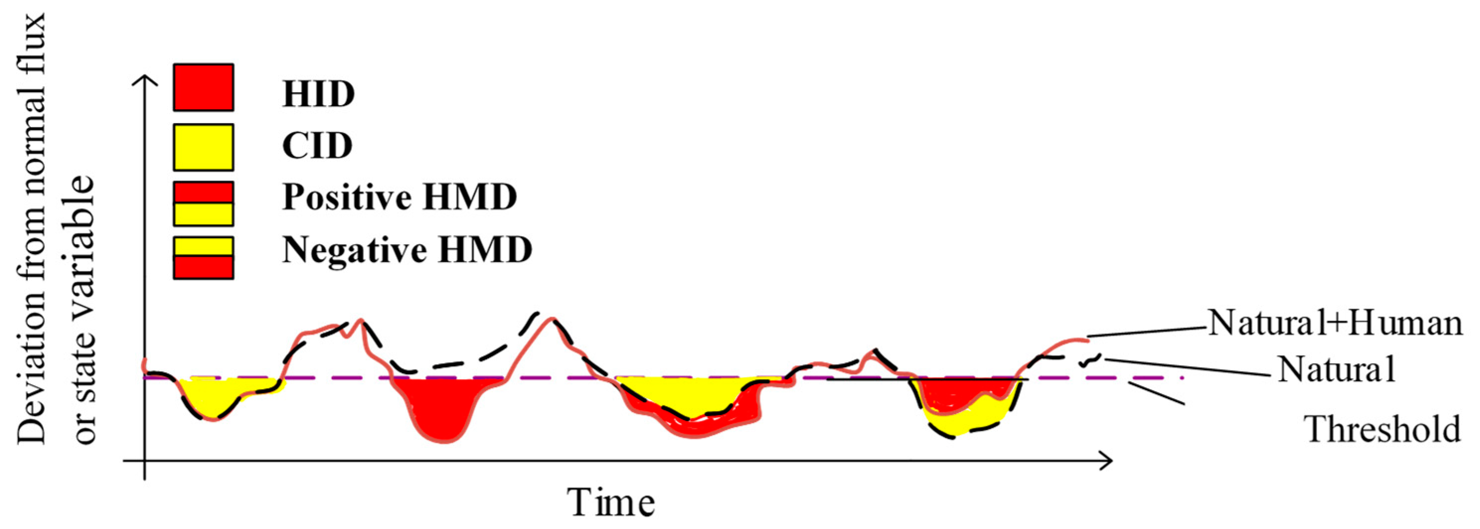
7]. Climate-induced drought is a type of hydrological drought caused only by natural drought drivers. In this type of drought, the anthropogenic drivers of drought are non-existent. Human-induced drought has been increasing due to human activities and anthropogenic drivers of drought in the absence of natural drivers [
6]. Finally, as a combination and simultaneously interaction of both natural and anthropogenic drivers, human-modified drought has been categorized as a third type of drought in the Anthropocene. Long-term human modification has the potential to mitigate or exacerbate human-induced drought severity, so that there can be both positive and negative human-modified drought. In vulnerable arid and semi-arid environments, human-modified drought has become a common natural hazard mainly because of the low annual precipitation, high level of human pressure on the water system, due to agricultural and industrial development, and rapid population growth.
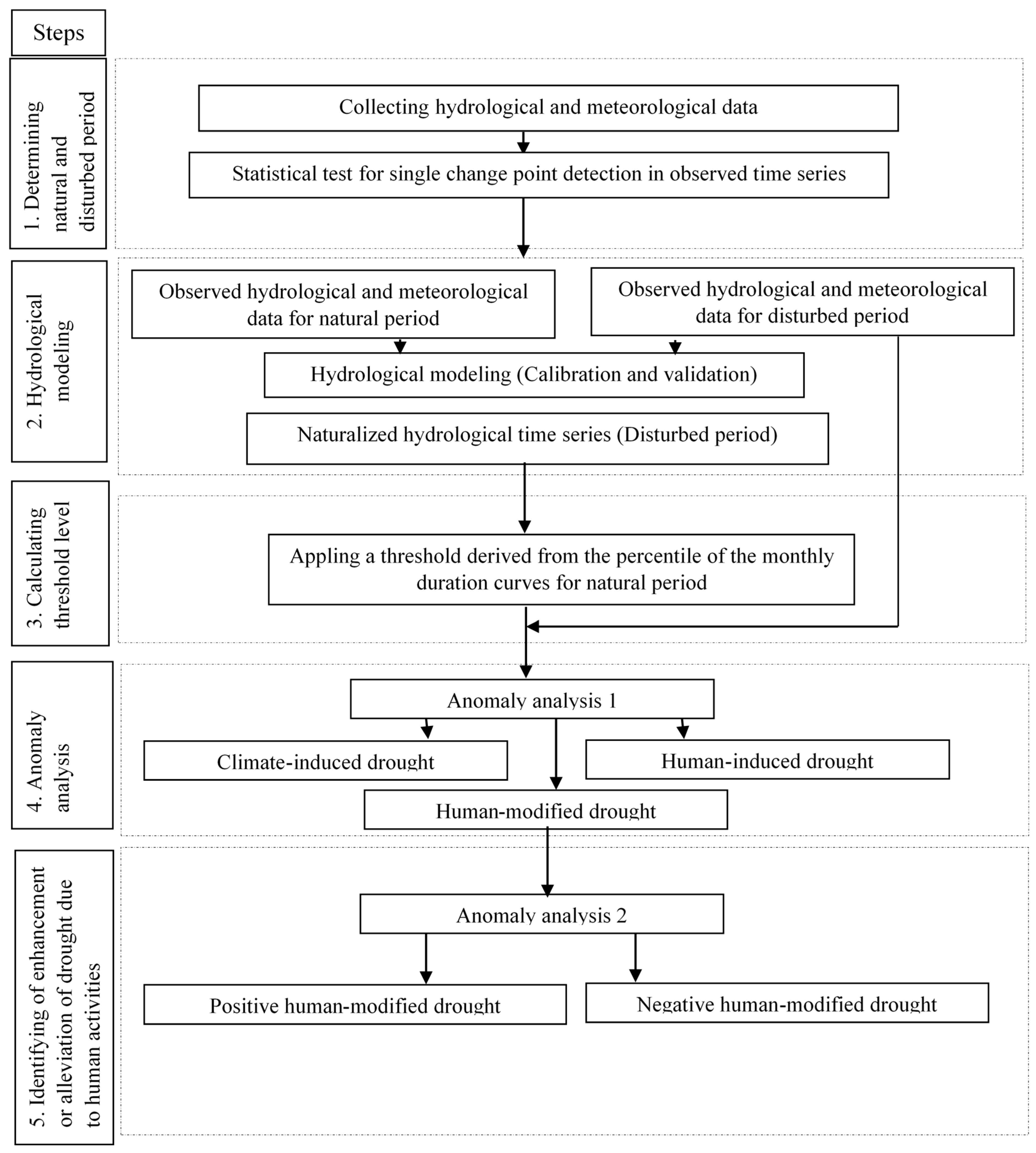
Until now, different approaches have been developed to quantify human influence on hydrological drought, e.g., (i) observation-modelling; (ii) upstream-downstream; (iii) paired catchment; (iv) pre-post-disturbance; and (v) large-scale screening.
The “observation-modelling” approach (i) is based on making a comparison between naturalized simulated and human-influenced observed drought events [
11]. This method is based on the availability of hydrological and meteorological data for the natural and disturbed period, irrespective of the region. It is possible to choose different kinds of hydrological models in the framework, e.g., stochastic, lumped and conceptual or physically based models. The kinds of required hydrometeorological variables depend on the choice of hydrological model. The “upstream-downstream” approach (ii) compares upstream drought events, which are not supposed to be affected by disturbance, with drought events downstream. This method needs observation time series of the variable of interest. Existing possible non-linear relationships between upstream and downstream can be a source of uncertainty in human drought studies using this method [
11,
12]. The “paired catchment” approach (iii) can quantify the human effect through comparing two nearby catchments with similar physical characteristics including the human affected catchment and the control benchmark catchment (with no human activity of interest) [
11]. This approach is a classical method in hydrology by which the impact of disturbance on the catchment hydrology can be detected [
13,
14]. The climatic variability can be assessed by considering the same time period [
15]. The “pre-post-disturbance” approach (iv) can make a before and after comparison between hydrological droughts of specific disturbances (pre-post-disturbance) [
16,
17] (e.g., Liu et al., 2016). In this approach, it is difficult to compare two different periods and make a distinction between the human effect and climate variability and climate change [
17]. The “large-scale screening” approach (v) can quantify different drivers of hydrological processes through large samples [
18] or comparative hydrology [
8]. The negative points of this approach are a need for too many catchments with long time series of hydrological variables and the type and degree of human changes in the hydrological system for each catchment should be available [
11].
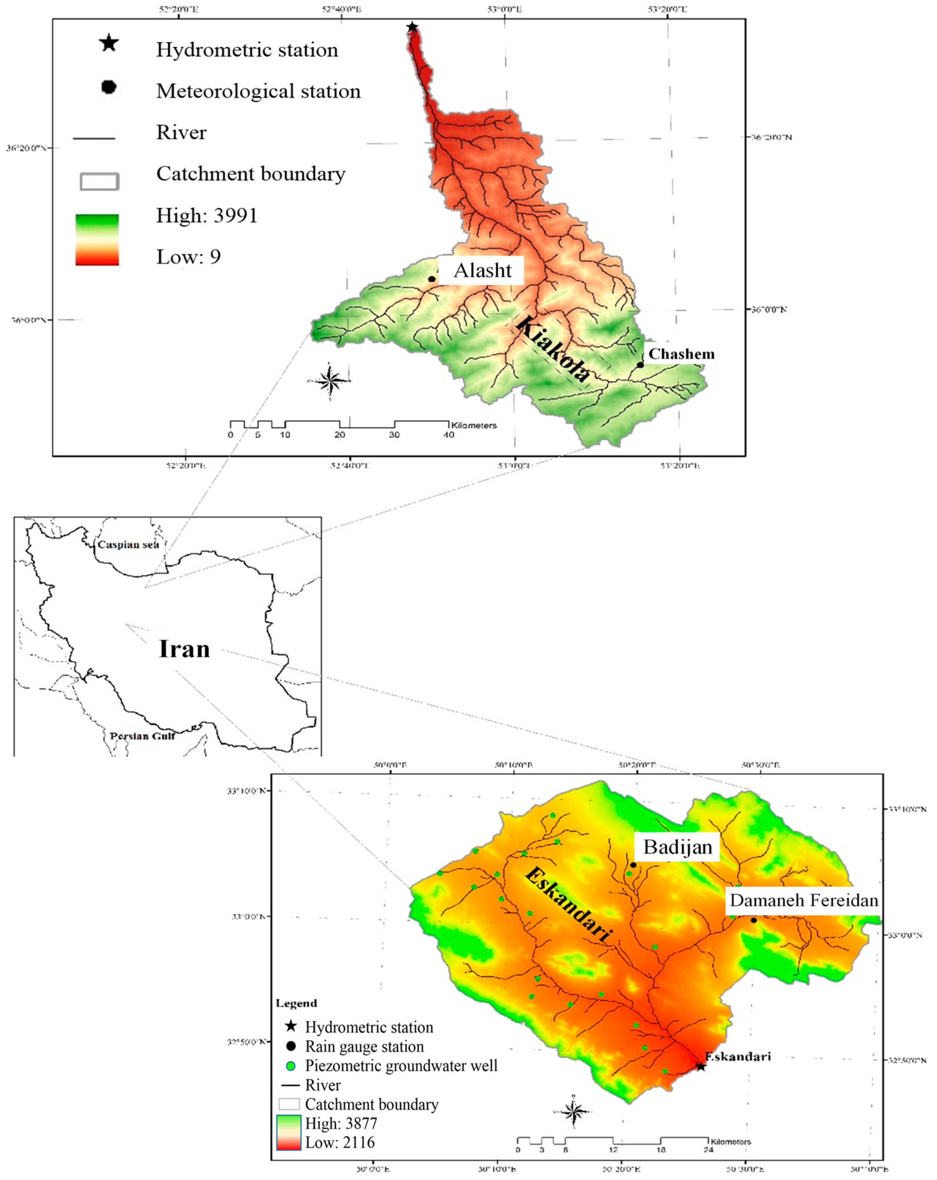
The aim of the current research was extending the “observation-modelling” approach as a step-wise methodology to assess different drought types in the human-influenced era, e.g., climate-induced, human-induced and human-modified droughts. In addition, quantifying alleviated or enhanced human-modified droughts is the second purpose of this study. Designing a methodology to identify the human-modified drought type is the motivation for the research. Therefore, the observation-modelling approach was utilized and extended to quantify the human effect on hydrological drought. The capability of the expanded methodology was assessed in two case studies in Iran, e.g., Kiakola and Eskandari (with major human intervention concerns) to answer three main questions as follows:
- (i)
What are the main and dominant types of drought?
- (ii)
How have human interventions changed drought types?
- (iii)
How has human modification enhanced or alleviated modified droughts?
The paper was formed as follows. In
Section 2, the case studies are explained in detail. The expanded approach and methodology are then described in
Section 3. Next, the results of the quantification of different hydrological droughts in the Anthropocene are shown in
Section 4. Finally, the discussion and conclusion are presented in
Section 5 and
Section 6, respectively.
5. Discussion
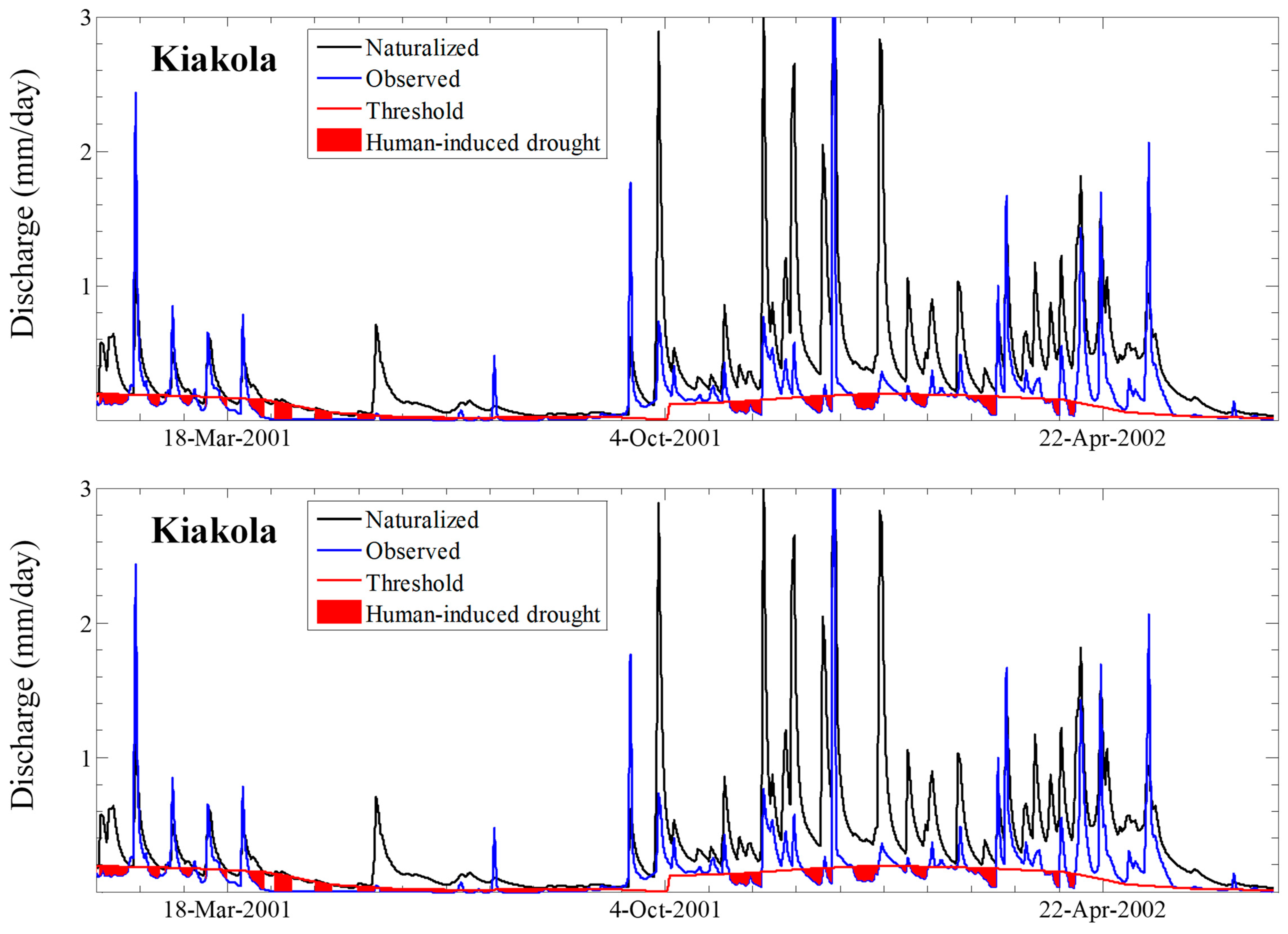
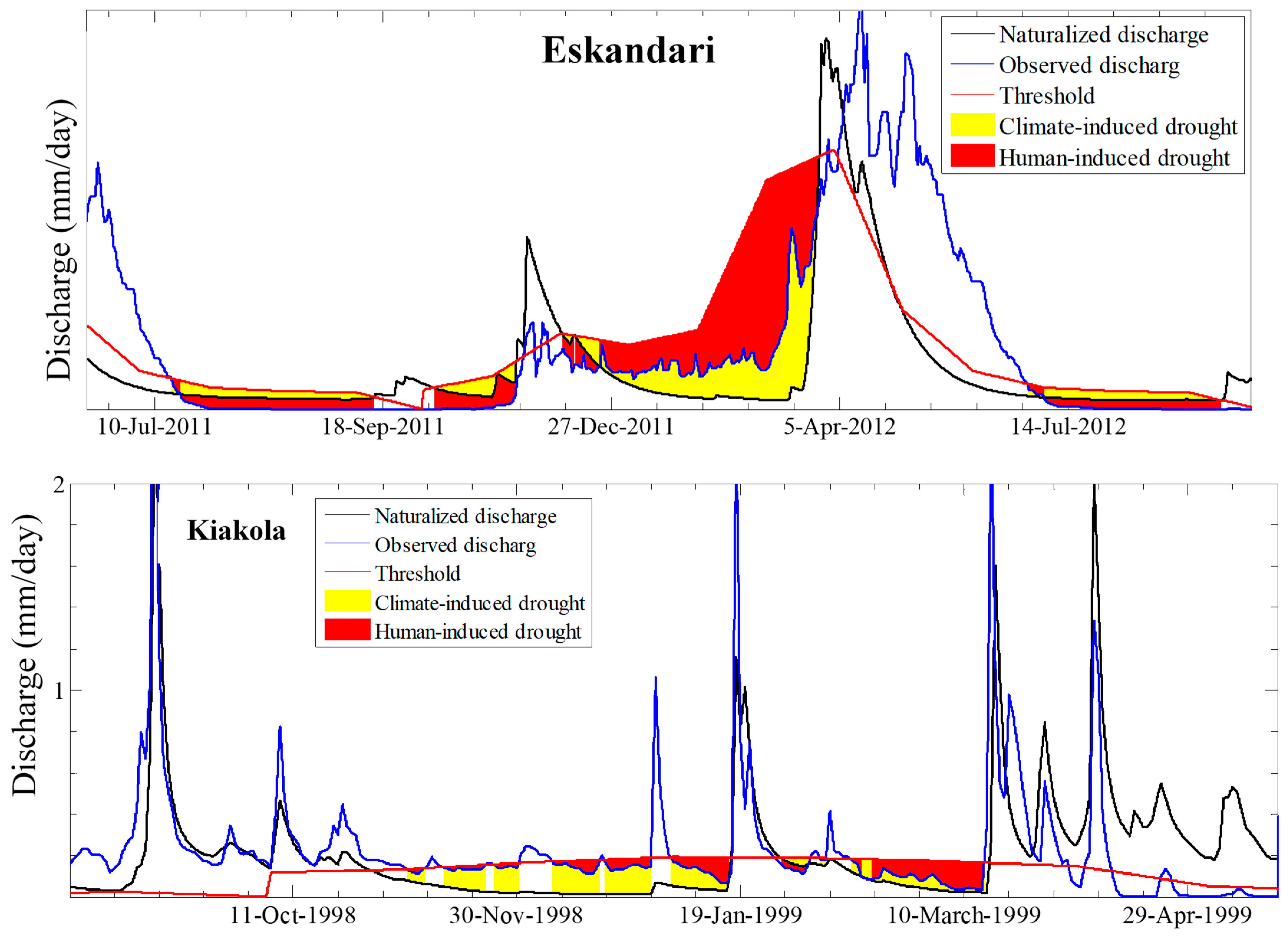
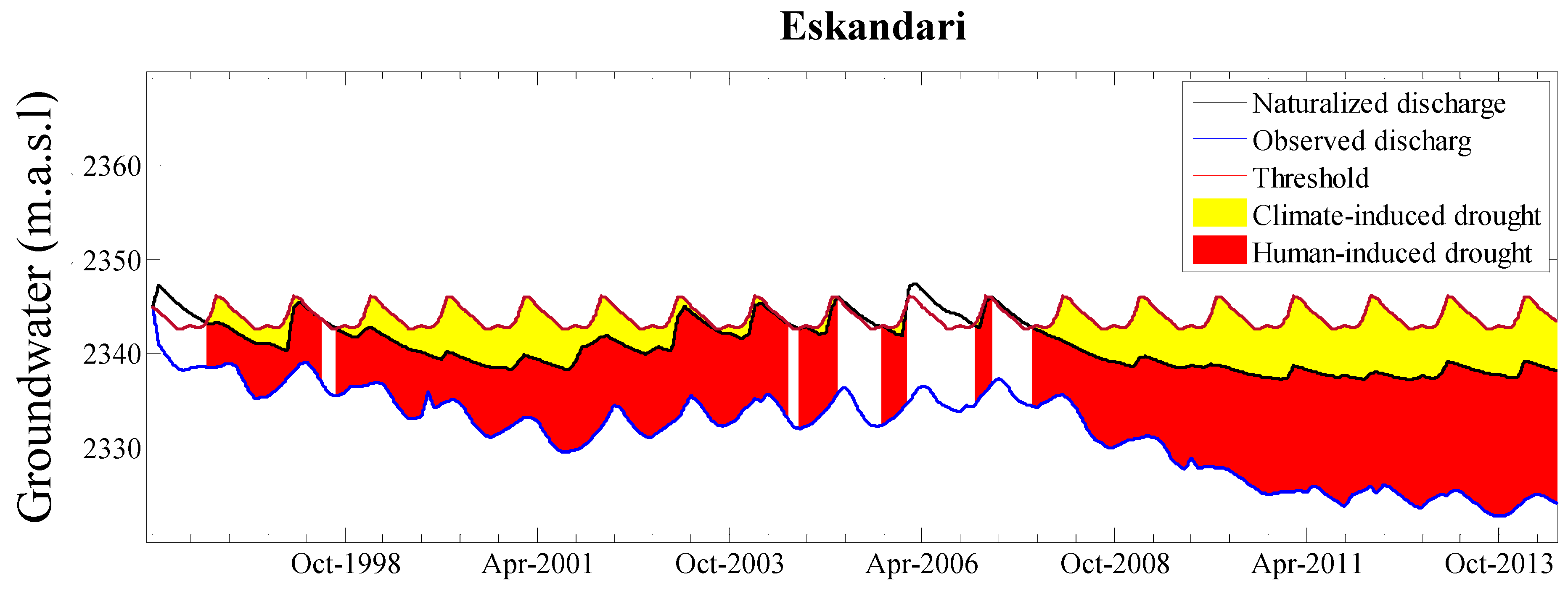
The current study presented a methodology by which the enhancing or alleviating effects of human drought drivers (
Figure 2) have been evaluated through extending the “observation-modelling” approach presented by Van Loon and Van Lanen (2013) [
6,
33,
48]. To demonstrate the extended approach and quantify positive and negative modified events, two Iranian catchments were chosen as examples with notable human intervention and different climatic conditions. For drought analysis, the monthly-variable thresholds were identified (Step 3) and anomaly analysis performed (Step 4). In this section, the application of other thresholds in drought specification and the portion of positive and negative modified droughts (Step 5) have been assessed by applying various percentiles, e.g., the 50th, 70th and 90th. The 90th and 50th values of thresholds were the lower and higher percentiles, respectively. The statistical summary of the results is shown in
Table 7. Applying different thresholds by various percentile values can alter the values of modified droughts. The results showed that in comparison to the 50th and 70th percentiles, the application of the 90th percentile threshold has created fewer modified droughts events with lower deficit volumes and shorter durations. The percentage of positive and negative modified droughts were not altered significantly by imposing various threshold and values of negative modified events were computed about 78–99%. The portion of positive modified groundwater events was altered between 0–17.9%, which was also very insignificant.
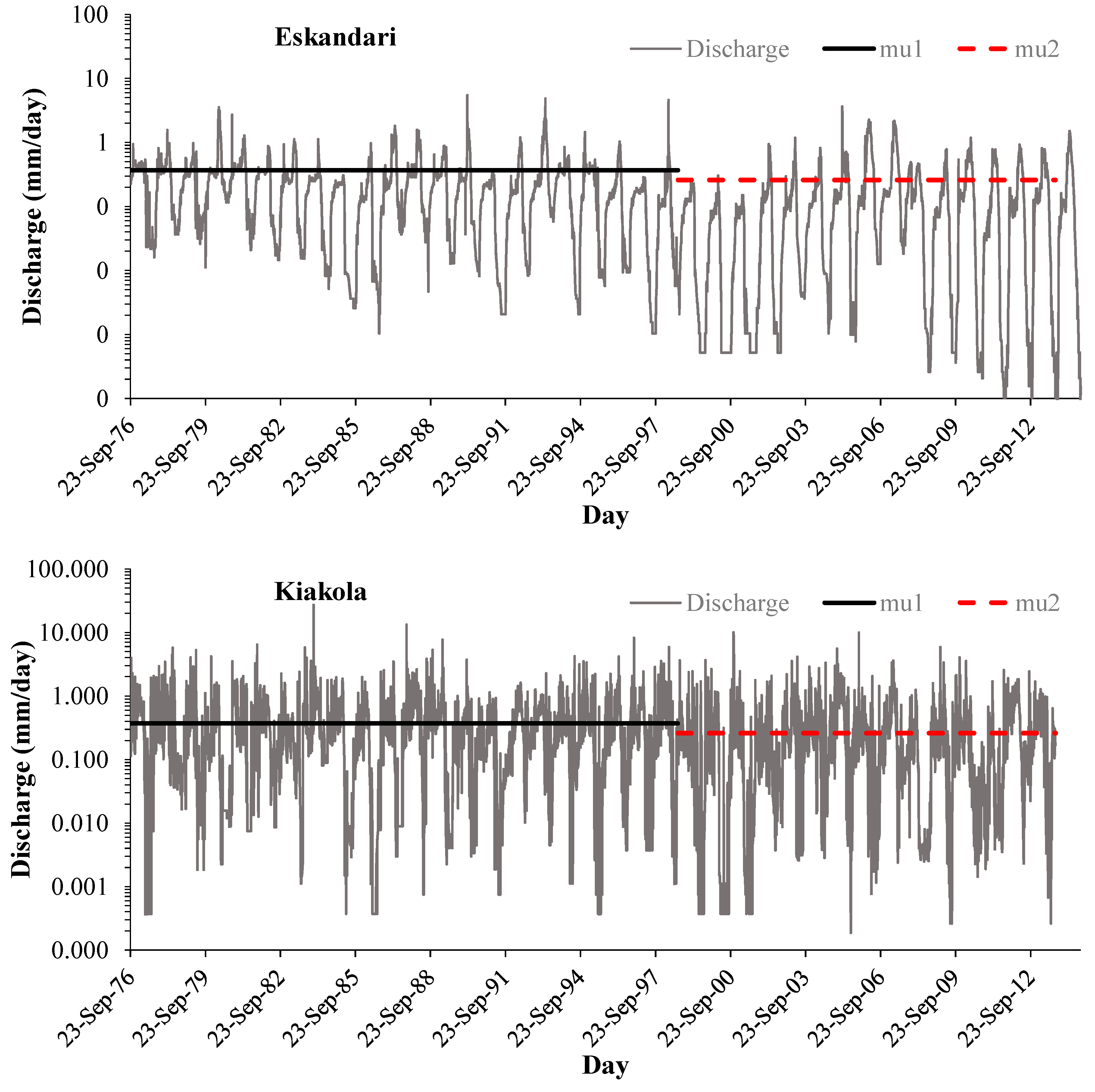
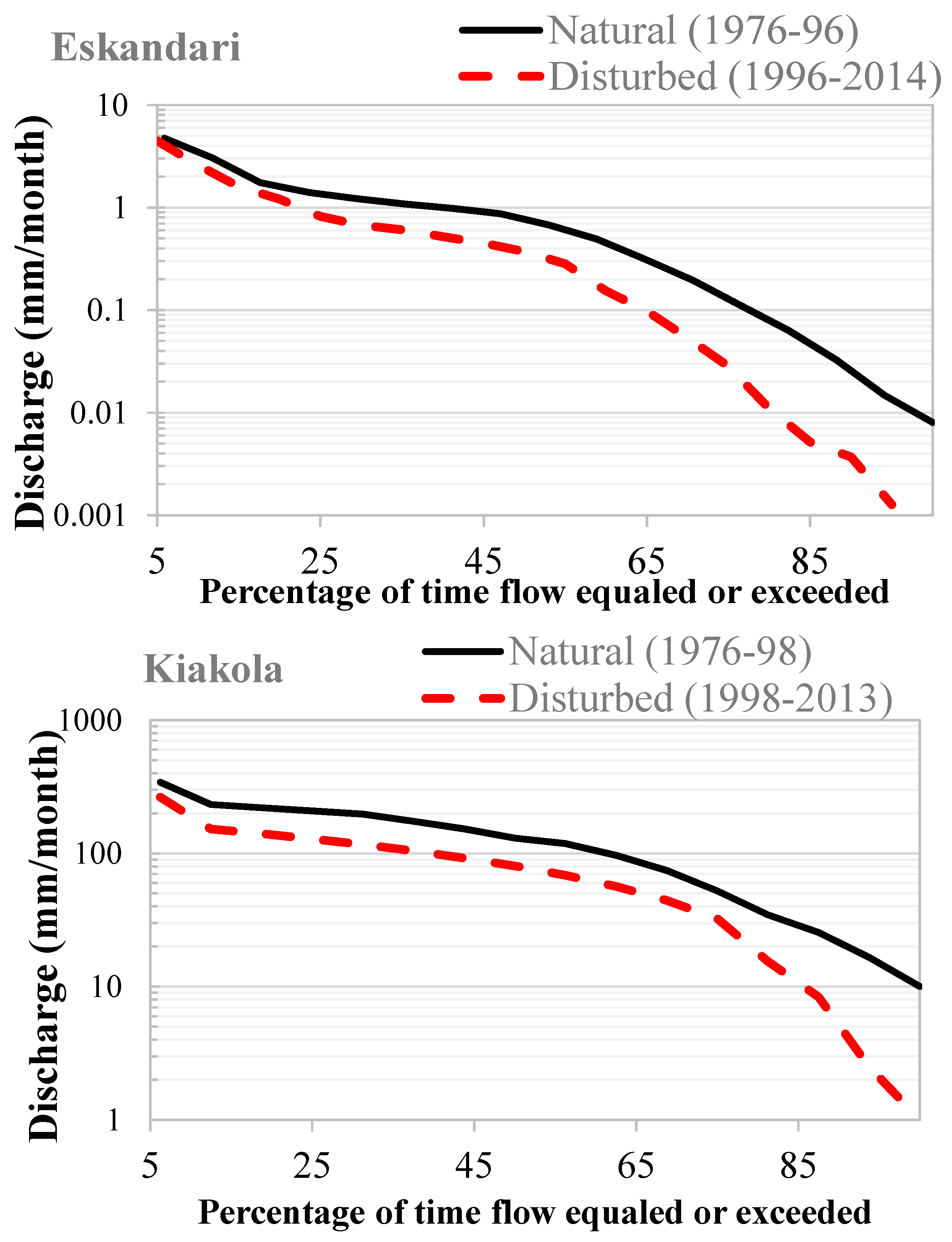
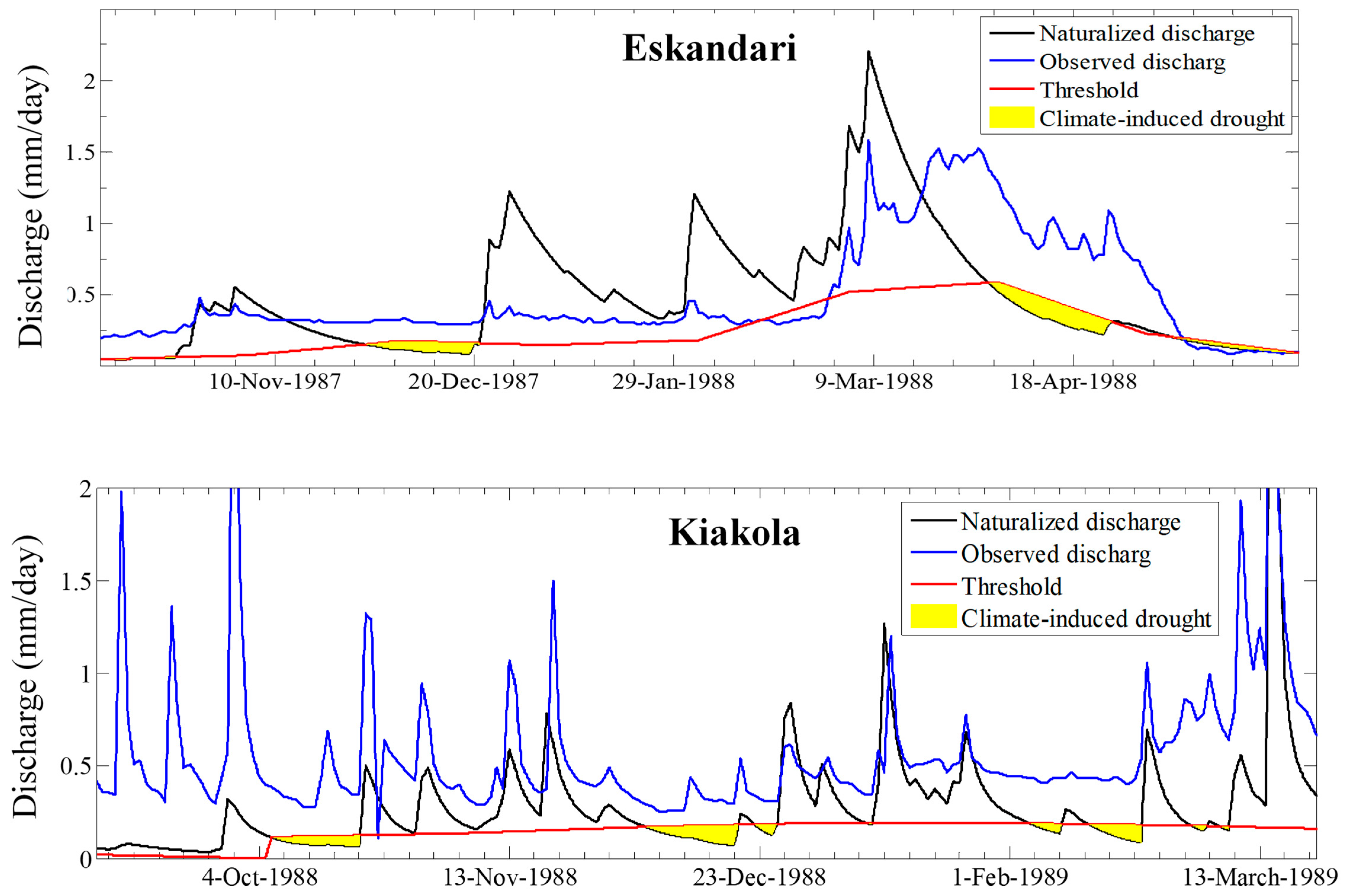
The obtained results showed that during the study period, human activities have a negative influence on the hydrological system in the Iranian catchments. In Eskandari, the positive and negative modified droughts happened in the wet season (November–March) and dry season (summer), respectively (
Figure 12 and
Figure 13). The positive events were also not considerable events in terms of the number of events, deficit volume and durations. Hence, the system was not able to recover from severe negative events during the wet season. To supply the water demand during the dry season, the abstraction of groundwater and surface water resources was increased. Therefore, the most severe natural droughts, i.e., climate-induced events, were turned into negative modified events in the dry season [
75,
76].
As mentioned in the introduction section, different approaches have been developed to quantify human influences on hydrological drought, e.g., observed-modelled, upstream-downstream, paired catchment, pre-post-disturbance, and large-scale screening.
At first, the “observed-modelled” framework was applied to quantify drought and water scarcity in the discharge and groundwater time series for the period of 1980–2000 in the Upper-Guadiana catchment in Spain [
33]. Discharge, rainfall and temperature were input data for rainfall-runoff modelling by the HBV model. In another study, the performance of the approach was evaluated in three catchments in the Czech Republic (Svitata and BILINA catchments) and the Netherlands (Poelsbeek catchment) to quantify drought and water scarcity [
48]. The lumped conceptual BILAN model and distributed physically-based SIMGRO were utilized as a hydrological model in the Czech Republic and the Netherlands, respectively. In 2016, this approach was applied to introduce and quantify three new concepts of watershed drought (WD), watershed water scarcity (WWS), and streamflow water scarcity (SWS) in Luanhe river basin, China [
2]. The physically-based semi-distributed SWAT model was applied to model runoff time series. Daily rainfall and discharge data of 21 stations, temperature and land use maps (1970 and 1980) were the input data. This method is based on the availability of hydrological and meteorological data for the natural and disturbed periods, irrespective of the region. The observed-modelled approach had acceptable performance in all the aforementioned studies. Naturalization of the hydrological system can be performed by hydrological modelling as a central point of the current methodology. It is possible to choose different kinds of hydrological models in the framework, e.g., stochastic, lumped and conceptual or physically based models. Therefore, the kinds of necessary hydrometeorological data depend on the choice of hydrological model. At the global scale, satellite hydrological data can be utilized. However, the high uncertainties of these kinds of data should be considered. Naturalization of the disturbed period time series is challenging and is extremely dependent on the precise calibration of the model, the regionalization methods and data about type and degree of human interventions with a suitable resolution.
Uncertainty is an intrinsic part of any hydrological modelling. In addition, the quality and quantity of hydrometeorological data of arid and semi-arid regions have been the biggest concern of modelling. In the selected case studies, long time series of observed hydrometeorological data were not available. The spatial distribution of rain gauges has also likely impacted on the modelling. Besides that, security issues and water conflicts and chaos that have occurred over the past years have led to a reduction in the availability of information in many parts of Iran. As precise quantitative or qualitative information on water resource development projects in the Eskandari catchment was not possible to provide because of security issues. In the current research, we tried to minimize the uncertainty to an acceptable level by using a genetic calibration algorithm (GAP optimization) to find an optimal parameter set. Selection of the threshold level type is a challenging issue. In arid and semi-arid regions, most of the time the rainfall is zero. In addition, the discharge time series contains considerable zero or close to zero values. Therefore, it is possible to detect extended dry periods for several months [
77,
78,
79]. Hence, it is possible to utilize the threshold of 50th percentile to be safe of a threshold of zero [
80,
81,
82].
The results of the current research with the presented methodology for two Iranian catchments has corresponded well to drought analysis during (2001–2009) in Australia. The information of climate (ENSO, STR, PDO, and IOD indexes), water resources (AWRA hydrological model), economic factors, and remote sensing data were used to quantify “Millennium Drought” [
83]. The previous study has also demonstrated that the deficit of negative modified drought has increased more the 50% because of the over-abstraction from underground water resources [
10].
Whether the occurrence of modified drought was dependent on the purpose and reservoir management has been discussed [
10]. The effect of reservoirs on hydrological drought in the Huasco basin in northern Chile has been assessed through the upstream-downstream approach for a long-term period of (1965–2013) [
12]. The approach was utilized for the observation and modelled streamflow time series to analyze the post-dam and pre-dam periods as disturbed and undisturbed periods, respectively. For a similar analysis, the naturalized and human-influenced scenarios were generated using WEAP (Water Evaluation and Planning) modelled data. For the same period, the natural differences were quantified between upstream and downstream using calculation of downstream changes relative to upstream. In addition, human changes during the disturbed period were calculated by accounting natural differences. The results showed that the data and methods for drought analysis in the Anthropocene need to be chosen carefully. As calculating the threshold for the undisturbed period as a reference period, made it possible to exclude the human impact from normal conditions. In addition, they showed how the two methods of the threshold level and standardized indices differed due to the differences between the methods and including or excluding the human changes in the “undisturbed” situation [
12]. The “paired-catchment” approach was applied in the UK (Chemler catchment as benchmark and Blackwater catchment) and Australia (Cockburn catchment as benchmark and Cox catchment) to quantify the human influence on hydrological drought [
11]. The results demonstrated that this approach has been able to quantify drought by observation data. However, they noted that the main limitation of the method was the uncertainty of observation and modelled data.
During the past decades, the Eskandari catchment has suffered from severe droughts especially during 1998–2001 [
83]. Over half of the population in the Zayandehrood basin has been influenced by the extended drought in 1998–2001 [
84]. During 1995–2011, land use changes as the main human activity have increased the areas of agricultural lands by about 11%. Therefore, the vulnerability of the hydrological system to drought has increased because of a decrease in the water flow. In 1997–2016, the areas of different land uses were also changed [
28]. The residential and agricultural areas have increased from 3679.8 km
2 and 7602.8 km
2 to 8574.05 km
2 and 8636.8 km
2, respectively. Rangelands and forest areas have decreased from 26,041.8 km
2 and 1499.8 km
2 to 21,285.5 km
2 and 930.54 km
2, respectively [
25]. Increasing irrigated areas during 1996–2000, crop pattern changes, and applying 20% conversion from wheat to rice cropping have increased water consumption and the risk of hydrological drought. In Eskandari, more than 60% of irrigation water was supplied through groundwater abstraction [
85]. In this area, water use efficiencies of all irrigation systems were very low (34%). Between 1956 and 2006, the rate of population growth has increased by about 5.9%. Hence, domestic and industrial demands have increased and hydrological droughts have aggregated. The construction of new water resources developments (e.g., Chadegan Reservoir and Kohrang Tunnels, from 1953–2020), by which the average annual yield increased from 1200 MCM in 1996 to 1790 MCM in 2010, could not overcome the vulnerability to drought under management practices.
In the Kiakola catchment, between 1991 and 2013 forest lands were reduced about 14.9% (from 83,902.75 ha to 71,424.71 ha). The areas of irrigated land, dry agricultural lands, rangelands and residential areas have increased by 46.8% (from 1017.82 ha to 1493.82 ha), 31.1% (from 23,272.06 ha to 30,520.31 ha), 4.7% (95,826.45 ha to 100,307.5 ha) and 17.5% (from 1563.77 ha to 1837.72 ha), respectively [
20]. In the Kiakola, a large portion of the water demand was supplied from groundwater (63.1%) and the rest was provided from surface water resources (36.9%). About 87.8%, 11.4% and 0.9% of groundwater resources were allocated for agriculture, drinking and industry purposes, respectively [
86].


