Abstract
Going beyond previous work, this paper presents a systematic literature review that explores the deployment of satellites, drones, and ground-based sensors for yield prediction in agriculture. It covers multiple aspects of the topic, including crop types, key sensor platforms, data analysis techniques, and performance in estimating yield. To this end, datasets from Scopus and Web of Science were analyzed, resulting in the full review of 269 out of 1429 retrieved publications. Our study revealed that China (93 articles, >1800 citations) and the USA (58 articles, >1600 citations) are prominent contributors in this field; while satellites were the primary remote sensing platform (62%), followed by airborne (30%) and proximal sensors (27%). Additionally, statistical methods were used in 157 articles, and model-based approaches were utilized in 60 articles, while machine learning and deep learning were employed in 142 articles and 62 articles, respectively. When comparing methods, machine learning and deep learning methods exhibited high accuracy in crop yield prediction, while other techniques also demonstrated success, contingent on the specific crop platform and method employed. The findings of this study serve as a comprehensive roadmap for researchers and farmers, enabling them to make data-driven decisions and optimize agricultural practices, paving the way towards a fully digitized yield prediction.
Keywords:
remote sensing; vegetation index; platforms; sensors; satellite; proximal; airborne; digital agriculture 4.0 1. Introduction
Estimating crop production is a crucial component in agriculture and has proven to be an effective approach for addressing food security concerns [1]. The World Health Organization [2] estimates that 820 million people worldwide still have insufficient access to food, while the Food and Agriculture Organization (FAO) projects a 70% increase in food demand required to support the global population of 9.1 billion by 2050 [3]. The droughts, floods, and heatwaves brought on by climate change are also putting added pressure on food production in many regions of the world [3]. In this context, yield prediction is an essential strategy that empowers farmers and the agricultural industry to manage resources efficiently, make informed decisions, and plan the harvesting, storage, processing, and logistics operations of the production, leading to increased productivity and cost savings. Moreover, timely forecasts enable farmers to plan for potential risks, such as severe weather events or pest outbreaks, allowing them to take prompt action and mitigate their impact [4]. Nevertheless, the estimation of crop production is a complex and intricate process that depends on a multitude of factors, such as the microclimate, weather, soil characteristics, fertilizer usage, and seed variety [5]. Therefore, numerous methods and techniques have been developed and used for optimizing yield prediction and improving the effectiveness of the developed models [6]. Precision agriculture could play a key role to yield estimation by utilizing various sensors including satellites, drones, and ground-based sensors, transforming the process of yield prediction by generating a plethora of data [7].
There have been a number of review papers focusing on the use of smart farming for yield prediction which offer insights into the challenges and opportunities of using remote sensing for crop management [8,9,10]. Several of these articles focus on the yield prediction of particular crops that are widely grown, such as maize, rice, sugarcane, sugar beet, and vines [11,12,13,14,15], while others include a more general overview of remote sensing technologies for specific application domains, such as crop management, crop monitoring, phenology, and other ecophysiological processes [16,17,18,19]. As reported [20], the relationship between vegetation indices obtained from remote sensing images (proximal, Unmanned Aerial Vehicles—UAVs, satellites) and crop yield is not static, but varies by vegetation stage. Towards this direction, a review of 69 studies by Benos et al. [21] highlighted a number of prediction levels at a specific vegetation stage or time before harvest. Schauberger et al. [22] performed a systematic review of crop yield forecasting methods in three often-used data domains: weather, remote sensing, and crop mask. By reviewing a large database (covering more than 350 articles), they reported that the most commonly-used models include statistical, process-based, and machine-learning models.
In relation to machine-learning models, the growing adoption of AI has allowed a noteworthy rise of studies focused on yield prediction [23,24,25]. Machine learning (ML) models treat the output, the crop yield, as an implicit function of the input variables, such as weather components and soil conditions, which can be very complex [26]. Many studies have used supervised and unsupervised learning, including various analytical models like Decision Trees, Random Forest, Support Vector Machines, Bayesian Networks, and Artificial Neural Networks [26,27,28]. Even though several review papers deliver a narrative overview of the topic [29,30,31], limited studies examine in depth all the necessary aspects for yield estimation. In this context, Van Klompenburg et al. [32] provided a systematic review of ML methods in yield prediction, including 567 relevant studies from six electronic databases. According to their findings, the algorithms that are most widely used were Neural Networks (NN) and Linear Regression algorithms, followed by Random Forest (RF) and Support Vector Machines (SVM). The most applied deep learning (DL) algorithm is Convolutional Neural Networks (CNN), and the other widely-used algorithms are Long-Short Term Memory (LSTM) and Deep Neural Networks (DNN). These findings are aligned with the systematic review of Oikonomidis et al. [33], who also reported the rapid increase of DL methods in crop yield prediction over the last five years. Similarly, the systematic review conducted by Muruganantham et al. [20] concluded that the performance and accuracy of the DL approach for crop yield prediction are better when compared to traditional ML approaches. Nevertheless, they are difficult to train and need recently developed hardware and optimization methodologies [34]. Large amounts of data are required to achieve good accuracy, and the complexity of DL approaches increases the algorithm’s time complexity [35]. When assessing ML techniques for achieving high levels of prediction performance, special attention should be given to different scales. Although prediction models at the regional scale could exhibit good accuracy, their usefulness to inform the decision-making of individual farmers might be severely limited according to the systematic review of Leukel et al. [36]. The review also accentuated the greater effort required for collecting field-level yield data (e.g., in-field sampling) compared with accessing readily available yield data from governmental bodies and regional associations. Wang et al. [33] also evaluated the applicability of DL for yield prediction on multiple scales and listed some representative studies regarding the nature of application and performance.
Although research has made great strides and crop yield prediction models can estimate the actual yield reasonably, better model performance is still desirable [37]. In the pursuit of enhancing agricultural productivity and ensuring food security, there is a pressing need for further advancements in yield prediction techniques. To address this requirement, this study aims to conduct a comprehensive systematic literature review, focusing on the deployment and integration of cutting-edge technologies such as satellites, airborne, and ground-based sensors in the context of crop yield prediction. By synthesizing this knowledge, we aim to provide valuable guidance for researchers, policymakers, and practitioners in the agriculture sector to make informed decisions and develop improved crop management strategies. Specifically, our review goes beyond previous work by combining multiple aspects of the topic including crop types, key sensors and platforms, data analysis techniques, and their respective performance for estimating yields. To this end, the following research questions are developed to guide the study:
- Which countries have been the key contributors to research related to the deployment of satellites, airborne, and ground-based sensors for crop yield prediction?
- Which crop types have been predominantly used for yield estimation in the context of remote sensing technologies?
- What are the most commonly employed remote sensing platforms and data analysis techniques for predicting crop yields in the existing literature?
- Among the various methods and platforms utilized, which ones have demonstrated better performance and accuracy in predicting crop yields?
By answering the above questions, this paper aims at providing a comprehensive and objective framework of the topic. It also identifies gaps in the existing research, and highlights hotspots where further investigation is needed in this rapidly growing field.
2. Materials and Methods
2.1. Scientific Article Search
In this study, peer-reviewed articles related to the application of remote sensing technologies in yield prediction were extracted, aiming to identify relevant studies from the earliest instances to the present day. To this end, a systematic search procedure was developed by utilizing Scopus “www.scopus.com (accessed on 1 February 2023)” and Web of Science (WoS) “www.webofscience.com (accessed on 1 February 2023)” search engines following the Preferred Reporting Items for Systematic Reviews and Meta-Analyses (PRISMA) framework [38]. Specifically, the PRISMA Statement consists of a 27-item checklist and a four-phase flow diagram, aiming at helping authors improve the reporting of systematic reviews and meta-analyses [38]. To ensure a comprehensive selection of relevant research articles for the analysis, the study’s approach was designed based on framed research questions and the aim of the review. It was acknowledged that using “yield prediction” alone as a search string would have generated a large number of published articles from various application fields that were not likely related to the aim of the review, leading to a complicated search. Therefore, the research words have been deliberately chosen, also considering relevant systematic reviews [22,32,39] to narrow down the focus from a main concept to a central idea. Specifically, the query used for encompassing all the works related to the topic without risking excluding any item is presented in Table 1.

Table 1.
Search engines and queries that were used for the scope of this study.
Then, a filtering step was conducted by exploiting the exclusion criteria directly available in the Scopus and WoS search engine, that is, document type, language, and publication year. Open-access articles published in the English language were only selected, while review articles and conference papers were excluded. This was based on the fact that open-access publishing adheres to the principles of open science, fostering transparency and ensuring that research is readily accessible for thorough examination, and thereby upholding the fundamental tenets of scientific integrity. Furthermore, the time span of the investigation encompassed the entire body of literature from 2002 to 2022.
The search query generated 725 records through Scopus and 704 through WoS, with publication data containing information on the “Author, Title, Source”, “Abstract, Keyword, Addresses”, and “Cited, References and Use” categories, organized into fields. Moreover, by removing the repeated and review articles across the two selected databases, 864 articles were screened by title and abstract.
2.2. Article Selection Criteria
The initially retrieved articles were chosen based on specific criteria, including the type of remote sensing technology utilized in the study and the method employed for yield prediction. Analyzing the abstracts of these articles aided in identifying relevant keywords and assisting in the article selection process. To ensure the relevance and focus of the review, the following exclusion criteria were applied:
- Records not pertinent to the research objective (e.g., satellite RNA in plant pathology) were excluded;
- Articles falling within the agricultural sector but not directly related to crop yield prediction were also removed from consideration;
- Publications that did not incorporate the use of satellites, airborne, or ground-based sensors for crop yield prediction were excluded;
- Literature search for articles that are published between 1 January 2002 to 31 December 2022;
- Articles were included only if they forecasted crop yield, either in absolute or relative terms, and provided performance metrics for evaluation. In order to ensure consistency and comparability, particular attention was given to the presence of evaluation metrics such as R2 (the coefficient of determination) and error metrics like the Root Mean Square Error (RMSE). Studies lacking these metrics were omitted from the dataset to standardize the evaluation process.
After applying all the exclusion criteria, a total of 456 full text articles were assessed for eligibility. Figure 1 presents the process for article selection and rejection from databases, based on the PRISMA framework.
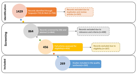
Figure 1.
Systematic review procedure for article selection.
The eligibility process involved thoroughly analyzing the full articles to ensure that only the studies that met the necessary aforementioned criteria were included. As a result, a total of 269 studies were deemed suitable and incorporated into this comprehensive review.
2.3. Scientific Studies Classification & Statistical Analysis
The selected papers were tabulated and standardized to enable comparison and systematic evaluation by extracting the following variables from each study:
- Study data: lead author, year, title, citations;
- Experiment setup: study region, type of crop;
- Platform type: Satellite, Airborne Measurements (Unmanned Aerial Systems—UAS or Manned Flight), Ground based Measurements;
- Method type: machine learning, statistical analysis, model-based approach, Vegetation Indices (VIs);
- Evaluation: performance measures (e.g., R2, RMSE, MAE).
Subsequently, the actual data collected from the papers were subjected to statistical analysis using XLSTAT software version 2016 from Addinsoft (www.xlstat.com, accessed on 1 April 2023). This analysis involved determining the number of research articles produced annually and by type. Additionally, further analyses were conducted based on crop type, platform type, sensor type, and the method’s focus area for each year over the past two decades.
3. Results and Discussion
One of the principal findings of this study pertains to the number of publications per year from 2002 to 2022, which sheds light on the evolving trends and research activity in the field of yield prediction using remote sensing technologies. According to Figure 2, from 2002 to 2012, the publication rate was low, with an average of roughly one paper per year. However, between 2013 to 2017, the publication rate increased to an average of approximately six papers annually, indicating a growth stage. From 2018 onwards, a rapid increase in publications is evident, confirming the growing interest among researchers, which also reflects the yield prediction used in the literature. Specifically, the number of publications surged from 15 in 2018 to 42 in 2020 and reached its peak at 92 in 2022.
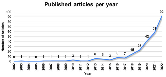
Figure 2.
Number of publications per year throughout the period 2002 to 2022.
The higher number of articles in the last years can be explained by a confluence of factors, such as technological advancements in the Information and Communications Technology (ICT) area, augmented research funding, and an expanding understanding of remote sensing applications.
The list of selected papers for the review is summarized in Appendix A, Table A1, which includes relevant information such as the Title, Crop, Method, and Platform used in each study. This comprehensive summary allows readers to access and refer to the key details of the selected papers efficiently, aiding in the understanding and evaluation of the research conducted for the review.
3.1. Key Contributor Countries
This systematic review also provided insights into the geographical distribution of research and the key contributors in the field. Specifically, studies have been conducted in 55 countries (Figure 3), with China most frequently appearing, followed by the USA, India, Australia, and Brazil. There are also many experiments in developing countries, but often only with a single study on a single crop. Forecasting efforts in Europe are spread out geographically, largely following country size and production share, with a dearth of studies particularly in Eastern Europe. It is important to highlight that these findings are related to the study areas within the articles, not the countries of authorship.
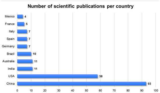
Figure 3.
Top 10 countries in terms of publications 2002–2022.
The most active country in terms of experiments for the whole period encompassed by this study is, clearly, China with over 93 publications. Following closely, the USA ranks second with 58 publications. India and Australia occupy the third and fourth positions, respectively, with 11 research studies each, while Brazil closely trails with 10 studies. In a more detached group, the majority then consists of European countries (Germany, Spain, Italy, France) with <8 publications.
The number of citations received is often used as a proxy for research quality. However, it should be noted that this metric alone may not provide a completely accurate representation, as various factors, including the research institute, the researchers’ country of origin, and the target audience, could influence citation counts [40]. Figure 4 illustrates the impact of research from different countries, and it becomes evident that China and the USA stand out, outperforming other countries in terms of citations. Notably, European countries, such as Germany and Spain, follow at a considerable distance with less than 370 citations, while Australia and Brazil are positioned further down the ranking. It is essential to highlight that these rankings are based on the currently available information and may be subject to updates as more recent citations become accessible, potentially influencing the relative positions of the countries in the future.

Figure 4.
Geographical distribution of citations for all the selected articles (2002–2022).
By examining publication patterns and citation metrics, it was possible to identify the countries that have made significant contributions to the topic of interest, helping researchers understand the global landscape of research and identify potential collaboration opportunities. It is evident that the USA and China have emerged as the most influential countries in the field of crop yield estimation using remote sensing technologies. These two (2) nations have demonstrated a significant presence with a substantial number of research articles focused on crop yield estimation, remote sensing applications, and related subjects. Moreover, their prominent position in terms of citations underscores their consistent production of high-quality research, substantial contributions to advancements in the field, and a profound understanding of effectively harnessing remote sensing data for accurate yield prediction. The notable impact of their research could be explained by the fact that they have the biggest economies and invest heavily in research and development. Consequently, they employ a large number of researchers who produce research publications [41].
3.2. Crops Used for Yield Estimation
The choice of crops for yield estimation is a pivotal aspect of research in the field of remote sensing-based agriculture. Through a thorough analysis of the literature, the study identified the most frequently studied crops used in yield estimation through remote sensing techniques. In total, the research encompassed a diverse array of crops, amounting to 48 different types, which were further classified into nine categories based on the Food and Agriculture Organization (FAO)’s classification [42]. Figure 5 illustrates the number of studies that included crops from each category and the prominent crops that have been extensively researched in the field of remote sensing-based yield estimations. Several studies addressed multiple crops, which means the total number of crops illustrated is greater than the number of studies analyzed.

Figure 5.
Categories of crops included in literature between 2002 and 2022.
Wheat (including durum wheat), maize, and rice emerge as highly studied crops, not only within the cereal category, but also overall. Additionally, oilseed crops, with soybeans leading the way, also receive significant attention in scientific publications. On the other hand, the fruits and nuts category along with vegetables and melons appeared to be the least researched category in terms of publications. It is noted that the category “Grass crops” comprises various crops, including Bachiaria pastures, Grassland, Miscanthus, perennial bioenergy grass, and ryegrass. Similarly, the category of “tomato” also includes research on processing tomato crops (Figure 6).
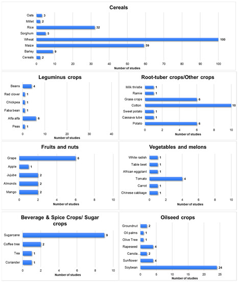
Figure 6.
Number of studies per crop category and crop.
Overall, the prominent crops that were commonly utilized for yield prediction included cereals and oilseed crops. These crops were selected due to their nutritional value and, therefore, their economic significance, data availability, and relevance to global food security [43,44]. Another key factor influencing their widespread use could be the availability of extensive datasets, encompassing historical yield records, agronomic practices, and weather data. Such data availability facilitates researchers in conducting comprehensive yield prediction studies with greater ease. Moreover, these crops do not exhibit complex structure-like vineyards and orchards that may affect remote sensing results [45]. The frequent application of agricultural practices like irrigation and pruning that are conducted in other crops such as vineyards and orchards, could also affect the interpretation of the remote sensing results [46]. As a result, researchers may face additional technical challenges and data processing requirements for these crops. In contrast, cereals and oilseed crops generally experience less interference from such practices, leading to more reliable and consistent remote sensing outcomes.
3.3. Remote Sensing Platforms for Yield Forecasting Used in the Literature
The literature on remote sensing platforms for crop yield forecasting is vast and diverse. Different remote sensing platforms have different advantages and limitations in terms of spatial resolution, temporal resolution, spectral resolution, radiometric resolution, coverage area, revisit frequency, data availability, data cost, and data processing requirements. Therefore, selecting the most suitable remote sensing platform for a specific crop yield forecasting application depends on several factors, such as the type of crop, the scale of analysis, the purpose of forecasting, the available resources, and the user preferences.
The results indicate that various remote sensing platforms were widely utilized for crop yield estimation, with many studies employing multiple platforms simultaneously. Notably, the majority of the reviewed studies (62%) utilized satellite remotely-sensed data to generate yield forecasts throughout the growing season. However, for small-scale studies conducted on experimental plots, ground-based sensors (27%) or airborne sensors (30%) were more commonly employed (Figure 7). Nonetheless, even in cases where multiple platforms were used, satellites remained the primary choice for crop yield estimation. This diverse usage of remote sensing platforms underscores their versatility and the benefits they offer in gathering essential data for crop yield forecasting across different spatial scales and agricultural contexts.

Figure 7.
Remote sensing platforms for yield forecasting used in the literature.
Satellites play a crucial role in crop yield prediction by utilizing a diverse range of sensors to measure electromagnetic radiation reflected or emitted from the Earth’s surface. Equipped with these sensors, satellites enable the spatial and multitemporal monitoring of soil and crop characteristics at different growth stages, providing valuable data for yield estimation. Figure 8 depicts the most common satellite systems used for yield prediction. Among the satellites commonly employed for this purpose, the Moderate Resolution Imaging Spectroradiometer (MODIS) emerges as the most frequently used, followed by Sentinel-2, Landsat, and Satellite pour l’Observation de la Terre (SPOT). Additionally, Synthetic Aperture Radar (SAR) sensors have also been utilized, with Sentinel-1 being the most prominent one.
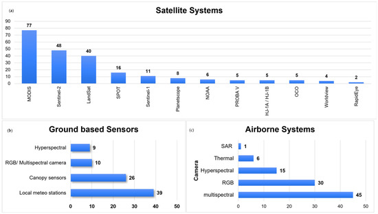
Figure 8.
(a) Satellite platforms for yield forecasting used in the literature; (b) ground-based platforms for yield forecasting used in the literature; (c) airborne platforms for yield forecasting used in the literature.
Yield predictions could also be derived based on data recorded from airborne platforms. According to the findings of this study, out of the total 269 studies reviewed, 84 of them utilized airborne data for crop yield prediction, including four manned flights. Among these, 45 studies utilized multispectral cameras, 30 studies deployed RGB cameras, and 15 studies utilized hyperspectral data. The least commonly used sensors were the thermal and synthetic aperture radar (SAR). It is obvious that several studies deployed more than one sensor, indicating the integration of multiple data sources to improve the accuracy and comprehensiveness of crop yield prediction models. The diverse usage of these sensors underscores the significance of integrating different data types to capture various aspects of crop growth and health for more informed yield forecasting.
In the case of ground-based sensors, the instruments were grouped based on their functionalities and applications. Specifically, the canopy sensors and analyzers category encompassed instruments for Chlorophyll Measurement (SPAD), Crop Health, and Nutrient Management (e.g., GreenSeeker, NTech Industries, Ukiah, CA, USA and CropCircle, Holland Scientific Inc., Lincoln, NA, USA), as well as Spectral Analysis and Canopy Analysis sensors (e.g., Spectroradiometer, spectrometers, Li-Cor 2000 Plant Canopy Analyzer, Li-Cor, Lincoln, NE, USA). Local meteorological stations were extensively deployed, appearing in 39 studies, making them the most commonly used ground-based sensors. Following closely, canopy sensors were frequently employed in the research. However, thermal sensors and LiDAR/Laser scanner data were the least deployed among the ground-based sensor categories.
Summarizing the results, researchers primarily utilized satellite platforms to acquire the necessary data for their studies. Satellites, compared to the rest of the platforms, can cover large areas and provide high temporal resolution, while being cost effective [47]. Moreover, satellites can be used in multisource data integration, such as the integration of optical and SAR remote sensing [48]. These advantages can explain why the majority of the studies incorporated satellite remote sensing approaches.
Respectively, UAS encompasses high spatial ground resolution and the ability to provide flexible and timely surveillance. However, UAS surveys require the storage and management of large amounts of data and preprocessing, while the datasets generated are limited to those collected by the user [49]. Consequently, deploying UASs on a commercial scale involves significant expenses, encompassing equipment, data processing, and software costs, which can be a substantial investment for small-scale farmers [50,51]. On the other hand, proximal sensors present distinct advantages in terms of precision and cost-effectiveness in agriculture. Since most of these sensors are active, they are not as restricted by weather conditions. Due to the close proximity in which the data are collected, there is less atmospheric interference, leading to more accurate data as well as high spatial resolution [52]. Nevertheless, they also have limitations pertaining to coverage, data interpretation, maintenance demands, and initial expenses. Therefore, the evaluation of the specific needs and available resources is essential when contemplating the adoption of remote sensor technology.
3.4. Data Analysis Techniques for Yield Forecasting Used in the Literature
Analyzing remote sensing products for yield prediction involves a range of methodologies that encompass ML, DL, statistical, and model-based approaches. These methods leverage the power of remote sensing data to estimate and predict crop yields accurately.
Based on the findings of this study (Figure 9), a statistical analysis is the most prevalent method employed for crop yield prediction in the reviewed studies. Following the statistical analysis, machine learning (ML) and deep learning (DL) methods are also widely used for yield estimation. In contrast, model-based approaches are observed to be utilized less frequently. Statistical analysis techniques often provide straightforward and interpretable relationships between variables, making them a popular choice for analyzing and understanding the impact of different factors on crop yields. Machine learning and deep learning methods, on the other hand, excel at capturing complex patterns and relationships in large and high-dimensional datasets, which is particularly advantageous when dealing with remote sensing data.
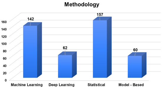
Figure 9.
Overview of the methodological approach in the studies considered.
One of the significant discoveries of this study is the prominence of the Random Forest algorithm, which appeared in 89 studies, making it the most commonly used approach for crop yield prediction. This is aligned with the findings of another systematic review by van Klompenburg et al. [32], which reported that Random Forest is one of the most used models along with Linear Regression and the Gradient Boosting Tree. Following closely, Support Vector Machine (SVM) was featured in more than 52 studies, while Linear regressors were utilized in over 30 studies. Both XGBoost and Partial Least Square Regression (PLSR) are also frequently utilized, with more than 20 and 11 studies, respectively. It is worth noting that the Lasso Regression is another commonly used regularization technique (>14 studies), employing an L1 penalty to encourage sparsity in the model, resulting in the selection of relevant features. Similarly, the Ridge regression (>eight studies) is a variation of Linear Regression that incorporates a regularization term to prevent overfitting and enhance model performance when addressing multicollinearity. These methods have garnered significant attention in various research studies and applications, demonstrating their efficacy and versatility in yield prediction. Moving on to Neural Networks, Artificial Neural Networks (ANN) and Convolutional Neural Networks (CNN) take the lead as the top-ranked approaches, with 16 and 13 studies, respectively.
An intriguing observation from the study is that there were only three studies that employed ML and DL approaches between 2007 and 2010, whereas the vast majority of these studies were published from 2017 to 2022. This significant increase in the use of ML/DL techniques in recent years indicates a growing interest and recognition of the power and potential of these advanced methods for crop yield prediction using remote sensing data.
Model-based approaches, though less prevalent in this context, offer valuable insights and predictions by simulating the entire crop growth process and its intricate relationship with the environment from an ecological physiology perspective. These models integrate various factors such as crop characteristics, soil conditions, climate, and management practices to comprehensively simulate crucial physiological processes, including crop respiration, photosynthesis, phenology, biomass accumulation, crop distribution, and ultimately estimate crop yields. In this systematic review, several model-based approaches appeared for crop yield prediction using remote sensing data. It is essential to emphasize that model-based approaches typically necessitate a range of inputs, making remotely-sensed weather and biomass data particularly valuable for obtaining temporal and spatial information on a large scale.
Among model-based approaches, the Decision Support System for Agrotechnology Transfer (DSSAT) model [53] stood out with 13 featured studies, providing valuable insights into agricultural management practices and crop responses to environmental conditions. The Simple Algorithm For Yield model (SAFY) and WOrld FOod STudies (WOFOST) model [54,55,56] were each present in seven studies, offering simulations of crop growth under water-limited conditions and diverse environmental scenarios, respectively. AQUACROP [57,58,59], used in four studies, focused on crop water productivity, evaluating yield responses to water availability and irrigation management. The Agricultural Production Systems Simulator (APSIM) model [60,61,62] was investigated in three studies, encompassing various aspects of crop growth and management. Additionally, the PROSAIL (Prospect and Sail) model, deployed in seven studies, served as a radiative transfer model, enabling the assessment of crop health through light interactions in vegetation canopies. While it does not directly generate yield predictions, it was employed in conjunction with other models (APSIM, WOFROST) to extract Leaf Area Index (LAI) values, which were then used to estimate biomass.
It is important to note that different crop models operate based on distinct driving factors. For example, WOFOST focuses on carbon dioxide (CO2), water, and temperature effects on yield, while AQUACROP emphasizes the impact of water stress on crop growth and yield, making it effective for simulating irrigation scenarios. APSIM, being a process-based model, considers a diverse range of soil processes, in addition to water balance and nutrient transformations [63]. Moreover, researchers have explored the benefits of coupled models, which combine two or more models with different principles and types. This approach aims to overcome the limitations of individual models, while capitalizing on their strengths, resulting in an improved simulation accuracy, modeling system stability, and reduced operational costs. These advances in model-based approaches contribute to a deeper understanding of crop–environment interactions and aid in making informed decisions for sustainable agricultural practices.
Each approach offered distinct advantages and addressed specific research objectives, enabling the extraction of meaningful information from remote sensing data for crop yield estimations. Specifically, the Statistical Analysis and Machine Learning methods are often used in crop yield estimation due to their ability to handle complex nonlinear relationships in high-dimensional datasets, as well as known parametric structures and unobserved cross-sectional heterogeneity [64]. Additionally, the performance of Deep Learning methods may be inadequate due to the fact that they heavily rely on the quality of the extracted features [65]. Finally, the low use of model-based methods on crop yield prediction could be explained by their high requirements for data and computational resources, and on their low flexibility compared to the other methods [66].
3.5. Spectral Vegetation Indices
Among the numerous vegetation indices developed, several have gained widespread adoption due to their effectiveness and versatility. As indicated by the results (Figure 10), the Normalized Difference Vegetation Index (NDVI) emerges as the most commonly used Vegetation Index. This can be explained by the high correlation this index presented, with key yield variables such as above ground biomass, crop height, and Leaf Area Index (LAI) [67,68]. The NDVI is also the most well-documented spectral vegetation index in the literature, resulting in reliable and accurate estimates of crop health and productivity, which are crucial for yield prediction [69]. Following closely is the Enhanced Vegetation Index (EVI), an improved vegetation index that addresses some of the limitations of the NDVI, particularly in areas with dense vegetation or atmospheric interference. Additionally, the LAI and Green Normalized Difference Vegetation Index (GNDVI) are widely employed in the studies. Each index offers unique advantages and applications, depending on specific research or monitoring objectives. Researchers, agronomists, and environmental scientists rely on these indices to analyze vegetation dynamics, assess crop health, monitor land cover changes, and make informed management decisions.
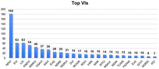
Figure 10.
Most widely used vegetation indices (VIs) for crop yield prediction.
It is evident that various vegetation indices have gained popularity for their effectiveness, with the Normalized Difference Vegetation Index (NDVI) being the most widely used. The NDVI’s strong correlation with key yield factors like biomass, crop height, and LAI contributes to its prevalence. The Enhanced Vegetation Index (EVI) is also popular, addressing the NDVI’s limitations in dense vegetation or atmospheric conditions. The Leaf Area Index (LAI) and Green Normalized Difference Vegetation Index (GNDVI) are frequently employed too. These indices aid researchers, agronomists, and environmental scientists in analyzing vegetation, assessing crop health, monitoring land changes, and making informed decisions.
3.6. Accuracy Performance per Crop Category
Assessing accuracy performance per crop category is crucial for understanding the effectiveness of different methods and platforms in estimating yields for specific crops, aiding in informed decision-making and optimizing agricultural practices. Consequently, the highest performance measures (R2) obtained for each study were extracted and organized into tables based on crop categories.
When comparing different methods in the case of sugar (Table 2), beverage, and spice crops, ML techniques exhibit high performance, as shown in the table (Table 2). Specifically, the Random Forest method stands out with a noteworthy RMSE of 1.51 t/ha and an R2 value of 0.94. It surpasses other methods including the Classification and Regression Tree, Support Vector Regression, and K-Nearest Neighbor [70]. This finding is in line with the results obtained by Canata et al. [71], where RF regression outperformed Multiple Linear Regression (MLR) in predicting sugarcane yields. Similarly, Martello et al. found that the RF regression yielded superior results in predicting coffee tree yields [72].
Table 2.
Reported method, platform, and R2, for sugar, beverage, and spice crop category.
Furthermore, the most common platform used was satellite systems, indicating encouraging prediction accuracies (R2 = 0.87) and RMSE = 11.33 (t·ha−1) when compared to actual harvested yields [78]. Additionally, the utilization of SAR-based yield prediction models have also proved the potential to assist and support sugar mill technicians in refining yield estimates [75]. Nevertheless, a study by Duveiller et al. [77] highlights that the estimation of sugarcane yield is influenced by various aspects, namely: (1) the way time is regarded (thermal or calendar); (2) the purity of the signal; (3) how the information is extracted from the time series (i.e., the type of metrics); and (4) the timing of when the information is available. These factors can explain the different range of R2 values retrieved from satellites for yield prediction (Table 2). Moral et al. [76] suggest that the empirical NDVI model is the most suitable approach for estimating sugarcane yield at the field level due to its simplicity and high accuracy throughout the entire crop cycle. In contrast to linear, logarithmic, power, and exponential models, a separate study [74] demonstrates that the polynomial model exhibits a significantly improved performance.
In the context of model-based yield prediction, the findings indicate a medium to high performance, with R2 values ranging from 0.64 to 0.86. This can be explained by the selection of the model. A study conducted in the USA compared three statistical models that incorporated remote sensing and weather data. Among these models, the SiPAR model demonstrated a superior yield prediction compared to the cumulated DNVI (CNDVI) and Kumar and Monteith (K–M) models [79].
In the crop category of Vegetables and Melons (Table 3), ML techniques have demonstrated a high performance as well, achieving an R2 value of 0.90. Apart from the deployed method, the selection of the VI plays a crucial role in achieving an optimal performance. According to the study conducted by Suarez et al. [83], the optimal results were produced when the Renormalized Vegetation Index (RDVI), Soil Adjusted Vegetation Index (SAVI), and Optimized Soil Adjusted Vegetation Index (OSAVI) were the predictor variables (R2 = 0.77), with the lowest σ (10.75 t/ha) achieved with RDVI. EVI2 also performed better (R2 = 0.55) than GNDVI (R2 = 0.29). Another study [84] focusing on processing tomato crops identified plant height and VIs during the early to mid-fruit formation period as significant variables for predicting shoot masses. Notably, the NDVI and Weighted Difference Vegetation Index (WDVI) were found to be significantly important for predicting tomato weight, while VIs one (1) month prior to harvest were significant in predicting fruit quantity.
Table 3.
Reported method, platform, and R2 for the Vegetables and Melons crop category.
Moreover, recent findings [88] suggest a strong correlation between the development stages of the primary canopy in processing tomatoes and their final yield. This correlation may indicate a crucial stage during which the crops undergo discernible changes that can be detected using satellite-derived data. Additional research demonstrates the possibility of predicting average tomato biomass and yield up to 8 weeks before harvest, as well as at the individual plant level up to 4 weeks prior to harvest [89]. By employing time-series phenotypic features derived from UAVs, researchers observed a strong individual correlation between these features and the actual yield. Linear Regression models produced high values (R2 > 0.7) in this regard [90].
In the context of oilseed crops (Table 4), the utilization of satellite NDVI series, captured fifty (50) days prior to harvest, has proven to be a reasonably accurate approach for estimating sunflower yields [91]. Furthermore, the effectiveness of Evolutionary Product-Unit Neural Network (EPUNN) models has been explored, revealing a superior accuracy compared to linear SMLR models, both in the training set and generalization set [92]. In the case of rapeseed yield estimation, plot-level VIs and leaf-related abundance showed a strong correlation, with an R2 value above 0.75. Among the tested VIs, multiplying the NDVI, Chlorophyll Index Red Edge (CIred edge), Transformed Vegetation Index (TVI), and SAVI by short-stalk-leaf abundance yielded the most accurate results for yield estimation in rapeseed [93]. When it comes to model-based methods [63], the WOFOST model in comparison with the coupled CASA-WOFOST model demonstrated a faster running speed in yield simulations while maintaining a similar accuracy. This makes the proposed CASA-WOFOST model suitable for large-scale assessments using high-spatial-resolution images to obtain accurate yield simulations. An investigation was conducted to assess the potential of multisensor optical and multiorbital SAR data for monitoring winter rapeseed crops using the SAFY agrometeorological model. The results demonstrated that the assimilation of both SAR-derived dry matter (DM) and the optically derived Green Area Index (GAI) allowed for better control of the model compared to using SAR or optical data alone. This integration notably improved the optimization of parameters governing dry matter partitioning into leaves and effective light-use efficiency [94]. Another crucial aspect in satellite-based crop yield estimation is the spatial and temporal resolution of the deployed satellites. As highlighted by Chen et al. [95], sparse time series of satellite remote sensing, caused by low-temporal-frequency and/or cloud contamination, pose significant challenges for accurate crop yield estimation at regional to national scales. To address this limitation, the blending of high-spatial-resolution but low-temporal-frequency images with low-spatial-resolution but high-temporal-frequency images was proposed. This approach aims to increase the temporal resolution, while preserving essential spatial details, potentially enhancing the accuracy of crop yield estimations.
Table 4.
Reported methods, platforms, and R2 for the Oilseed Crop category.
It is not surprising to find numerous studies that involve soybeans in their research, as soybean is a widely cultivated and economically important crop. A study [111] comparing various spatial resolutions found compelling evidence in favor of higher resolution imagery over lower resolution options. The authors suggest selecting an NDVI resolution that matches or exceeds the current cropland mask resolution, taking into consideration factors such as computation cost. Notably, an interesting finding from another research study [122] is that county-scale models perform relatively poorly in field-scale validation (R2 = 0.32), particularly in high-yielding fields. However, these county-scale models show a similar performance to field-scale models when evaluated at the county level (R2 = 0.82).
In the Fruits and Nuts category (Table 5), orchard yield estimation has predominantly been conducted using proximal sensing and airborne sensing, or a combination of both along with satellite data. High-resolution satellite images have also been employed as a standalone method, achieving a satisfactory performance with an R2-value of 0.87 [125,126]. The high efficiency of these methods could be attributed to their reliance on visual counting and the utilization of high-resolution data, which enable accurate and efficient orchard production estimations. Few studies used above-ground remote sensing to estimate tree production. The correlation between tree production and remotely-assessed features is not generic, and has to be calibrated for each orchard and each year to include climate and site effects [127].
Table 5.
Reported methods, platforms, and R2 for the Fruits and Nuts crop category.
In relation to root tuber and other crops (Table 6), ML approaches are quite common, achieving a higher (>0.90) performance in terms of accuracy when compared to other methods. In cotton cultivation, developing efficient tools for precise yield estimation before harvest is crucial, and the UAV multispectral remote sensing system holds significant potential for rapidly, accurately, and economically assessing agricultural crop characteristics and yields. The connection between crop growth indicators like LAI and chlorophyll with canopy spectral reflectance allows spectral indices collected during the growing season to be utilized for crop yield estimation, given the correlation between yield and the amount of photosynthetic tissue. This enables wide-scale application, contrasting with traditional measurements of agronomic parameters such as LAI and chlorophyll [137]. Additionally, the feasibility of estimating cotton yield using low-altitude UAV imaging was verified in this study [138].
Table 6.
Reported methods, platforms, and R2 for the Root tuber and other crops category.
Researchers used mixed data sources, including airborne satellites and proximal sensors, to gather information and insights about leguminous crops (Table 7). Some studies may solely focus on using ML or DL algorithms, while others might combine both approaches or incorporate statistical methods for enhanced accuracy and interpretability. In the study conducted by Minch et al. [159], efficient flight parameters were investigated to create successful models for determining canopy heights, specifically for alfalfa yield estimation. The researchers strongly recommend using a flight parameter within the range of 50–75°, as it is likely to yield optimal data for accurate canopy height estimation in alfalfa fields.
Table 7.
Reported methods, platforms, and R2 for the Leguminous crop category.
The category of cereals encompasses a wide range of methods and platforms, prompting its separation into two tables: cereals (Table 8), and maize and wheat (Table 9).
Table 8.
Reported methods, platforms, and R2 for the cereal crop category.
Table 9.
Reported methods, platforms, and R2 for wheat and maize.
In the table focusing on wheat and maize (Table 9), it becomes evident that these crops have received special attention in the literature. The number of research papers dedicated to studying wheat and maize yield prediction is higher compared to other cereals, indicating their prominence in agricultural research. Moreover, the utilization of diverse approaches in predicting the yields of wheat and maize is also noteworthy. Researchers have explored a wide range of methods and platforms, including various machine learning algorithms, statistical models, and remote sensing technologies such as UAV multispectral imaging and satellite data.
Upon close examination of the provided table (Table 9), it becomes evident that a definitive and uniform trend in the methodologies employed for yield prediction is lacking. However, maize and, secondarily, wheat, rice, and soybean have emerged as extensively studied crops through the application of machine learning techniques. This observation is in accordance with the insights documented by Benos et al. [21]. The authors also reported that UAVs are constantly gaining ground against satellites mainly because of their flexibility and ability to provide images with high resolution under any weather conditions. Satellites, on the other hand, could supply time-series over large areas. At the same time, the range of approaches utilized aligns with a prior study [22] that has also observed a variety of methods used in predicting yields for staple crops, emphasizing that each new setting requires appropriate validation.
This information can be valuable for policymakers, farmers, and researchers to make informed decisions, optimize agricultural practices, and address food security challenges in an ever-changing climate and agricultural landscape.
Overall, the results emphasize the importance of assessing an accuracy performance for specific crop categories to enhance yield estimation methods. The highest performance measures (R2) from various studies were compiled into tables based on crop categories. Machine Learning (ML) techniques, particularly Random Forest, excel in predicting sugar, beverage, and spice crops. Satellite systems, including the Synthetic Aperture Radar (SAR), prove effective for sugarcane yield prediction. In vegetables, ML methods give promising results, considering key vegetation indices. Orchards benefit from proximal and airborne sensing, while leguminous crops are studied using a mix of ML, DL, and statistical methods. Wheat and maize receive extensive attention, employing diverse methods including ML, DL, statistical, and model-based approaches.
Finally, it is necessary to pinpoint an important constraint of this study. Due to the extensive volume of articles analyzed and the diverse methodologies employed therein, specific details concerning the performance assessment were not documented. These details include whether cross-validation was utilized, whether the testing dataset was segregated, or if the same dataset was employed for both training and model validation.
4. Conclusions
By employing this systematic approach to data analysis, the study aims to provide valuable insights into the trends, patterns, and contributions of different methodologies and technologies in the field of crop yield prediction using remote sensing tools.
Understanding the geographical distribution of research efforts and the significant academic institution in this domain is crucial for comprehending the research landscape. Our research revealed that China (93 articles with over 1800 citations) and the USA (58 articles with over 1600 citations) are key contributors to the field of crop yield prediction using remote sensing techniques. Based on the results, cereal crops (185 papers) emerged as the most commonly studied for yield estimation with wheat being the most predominant crop. Among the remote sensing platforms, satellites (62%) were the most frequently employed platforms followed by airborne (30%) and proximal sensors (27%). The study extensively evaluated various algorithms and models for predicting crop yields based on remote sensing data. In terms of methodologies, machine learning was featured in 142 articles, while deep learning was employed in 62 articles for the purpose of yield prediction. Furthermore, statistical methods were utilized in 157 articles, and model-based approaches were featured in 60 articles as mechanisms for predicting crop yields. The performance of machine learning and deep learning methods has shown high accuracy in crop yield prediction, while other techniques have also demonstrated success depending on the crop and method. These insights offer a comprehensive understanding of the research domain and could guide future advancements in remote sensing-based crop yield estimations.
By consolidating and analyzing data from multiple studies, our research contributes to a comprehensive understanding of the current state of remote sensing-based crop yield estimation. This synthesis helps identify trends, gaps, and areas of progress in the research domain, providing valuable guidance for future studies in this area. The identified influential countries, methodologies, and successful algorithms can serve as a foundation for designing more effective and targeted research.
The findings of this study hold the potential to advance the accuracy and applicability of remote sensing-based crop yield estimation techniques. This, in turn, could contribute to improved agricultural management practices, increased food security, and sustainable agriculture. The comprehensive overview provided by this research empowers the scientific community to make informed decisions and develop innovative approaches to further enhance the accuracy and utility of remote sensing-based crop yield estimation methods in the future.
Author Contributions
N.D.: principal investigation, research supervision, data collection, data preprocessing, study design and methodology, statistical and formal analysis, and manuscript writing; E.A.: investigation, research supervision, study design and methodology, data curation, statistical and formal analysis, cross validation, and manuscript writing; E.L. and O.K.: data collection, data preprocessing, and manuscript review and editing; D.K. and S.F.: principal investigation, research supervision and manuscript revision and editing. All authors have read and agreed to the published version of the manuscript.
Funding
This research received no external funding.
Data Availability Statement
The data used in this manuscript is open and can be accessed through Scopus and WOS search engines.
Conflicts of Interest
The authors declare no conflict of interest.
Appendix A
Table A1 includes the list of studies that were analyzed in the context of the systematic review.
Table A1.
List of studies included in the systematic review.
Table A1.
List of studies included in the systematic review.
| Article | References | Crop | Method | Platform | Year | |
|---|---|---|---|---|---|---|
| 1 | Comparison of earth observing-1 ALI and Landsat ETM+ for crop identification and yield prediction in Mexico | [219] | Maize, Wheat | Statistical | Satellite | 2003 |
| 2 | Early prediction of crop production using drought indices at different timescales and remote sensing data: application in the Ebro Valley (north-east Spain) | [174] | Wheat, Barley | Statistical | Satellite | 2006 |
| 3 | Estimating crop yield from multi-temporal satellite data using multivariate regression and neural network techniques | [102] | Maize, Soybean | ML/DL Statistical | Satellite | 2007 |
| 4 | Mapping sunflower yield as affected by Ridolfia segetum patches and elevation by applying evolutionary product unit neural networks to remote sensed data | [92] | Sunflower | ML/DL Statistical | Airborne | 2008 |
| 5 | Use of Vegetation Health Data for Estimation of Aus Rice Yield in Bangladesh | [184] | Rice | Statistical | Satellite | 2009 |
| 6 | Integrating Vegetation Indices Models and Phenological Classification with Composite SAR and Optical Data for Cereal Yield Estimation in Finland (Part I) | [175] | Summer Wheat, Barley, and Oats | Statistical | Satellite × Airborne × Proximal | 2010 |
| 7 | Cereal Yield Modeling in Finland Using Optical and Radar Remote Sensing | [172] | Cereal | Statistical | Satellite | 2010 |
| 8 | Application of vegetation indices for agricultural crop yield prediction using neural network techniques | [245] | Maize | ML/DL | Airborne | 2010 |
| 9 | Using SPOT data and leaf area index for rice yield estimation in Egyptian Nile delta | [185] | Rice | Statistical | Satellite | 2011 |
| 10 | Estimating regional wheat yield from the shape of decreasing curves of green area index temporal profiles retrieved from MODIS data | [255] | Wheat | Statistical | Satellite | 2012 |
| 11 | Forecasting regional sugarcane yield based on time integral and spatial aggregation of MODIS NDVI | [73] | Sugarcane | Statistical | Satellite × Proximal | 2013 |
| 12 | Estimating regional winter wheat yield by assimilation of time series of HJ-1 CCD NDVI into WOFOST-ACRM model with Ensemble Kalman Filter | [284] | Wheat | Model based | Satellite | 2013 |
| 13 | Enhanced processing of 1-km spatial resolution fAPAR time series for sugarcane yield forecasting and monitoring | [77] | Sugarcane | Statistical | Satellite | 2013 |
| 14 | Remote sensing based yield estimation in a stochastic framework—Case study of durum wheat in Tunisia | [256] | Wheat | Statistical | Satellite | 2013 |
| 15 | Rice yield forecasting models using satellite imagery in Egypt | [186] | Rice | Statistical | Satellite | 2013 |
| 16 | Remotely Sensed Rice Yield Prediction Using Multi-Temporal NDVI Data Derived from NOAA’s-AVHRR | [187] | Rice | Statistical | Satellite | 2013 |
| 17 | Corn yield forecasting in northeast China using remotely sensed spectral indices and crop phenology metrics | [218] | Maize | Statistical | Satellite | 2014 |
| 18 | Estimation of the dynamics and yields of cereals in a semi-arid area using remote sensing and the SAFY growth model | [176] | Wheat and Barley | Model based Statistical | Satellite | 2014 |
| 19 | The use of ALOS/PALSAR data for estimating sugarcane productivity | [75] | Sugarcane | Statistical | Satellite | 2014 |
| 20 | Toward a satellite-based system of sugarcane yield estimation and forecasting in smallholder farming conditions: A case study on reunion island | [76] | Sugarcane | Statistical | Satellite | 2014 |
| 21 | Combined spectral and spatial modeling of corn yield based on aerial images and crop surface models acquired with an unmanned aircraft system | [215] | Maize | Statistical | Airborne | 2014 |
| 22 | Using a remote sensing-supported hydro-agroecological model for field-scale simulation of heterogeneous crop growth and yield: Application for wheat in central Europe | [326] | Wheat | Model based Statistical | Satellite × Proximal | 2015 |
| 23 | Improving winter wheat yield estimation by assimilation of the leaf area index from Landsat TM and MODIS data into the WOFOST model | [267] | Wheat | Model based Statistical | Satellite | 2015 |
| 24 | Assimilation of two variables derived from hyperspectral data into the DSSAT-CERES model for grain yield and quality estimation | [294] | Wheat | Model based Statistical | Proximal | 2015 |
| 25 | Assessment of multimodel ensemble seasonal hindcasts for satellite-based rice yield prediction | [208] | Rice | Statistical | Satellite × Proximal | 2016 |
| 26 | Early Maize Yield Forecasting from Remotely Sensed Temperature/Vegetation Index Measurements | [217] | Maize | Statistical | Satellite | 2016 |
| 27 | Correlation maps to assess soybean yield from EVI data in Paraná State, Brazil | [106] | Soybean | Statistical | Satellite | 2016 |
| 28 | Estimation of winter wheat biomass and yield by combining the aquacrop model and field hyperspectral data | [295] | Wheat | Model based Statistical | Proximal | 2016 |
| 29 | Improving spring maize yield estimation at field scale by assimilating time-series HJ-1 CCD data into the WOFOST model using a new method with fast algorithms | [229] | Maize | Model based | Satellite | 2016 |
| 30 | Prediction of potato crop yield using precision agriculture techniques | [139] | Potato | Statistical | Satellite | 2016 |
| 31 | Rice yield estimation using below cloud remote sensing images acquired by unmanned airborne vehicle system | [210] | Rice | Statistical | Airborne | 2016 |
| 32 | Cotton growth modeling and assessment using unmanned aircraft system visual-band imagery | [143] | Cotton | Statistical | Airborne | 2016 |
| 33 | Daily mapping of 30 m LAI and NDVI for grape yield prediction in California vineyards | [128] | Vineyards | Statistical | Satellite × Proximal | 2017 |
| 34 | Analysis of meteorological variations on wheat yield and its estimation using remotely sensed data. A case study of selected districts of Punjab Province, Pakistan (2001–14) | [257] | Wheat | Statistical | Satellite | 2017 |
| 35 | Forecasting winter wheat yields using MODIS NDVI data for the Central Free State region | [258] | Wheat | Statistical | Satellite | 2017 |
| 36 | Using MODIS Data to Predict Regional Corn Yields | [216] | Maize | Statistical | Satellite | 2017 |
| 37 | Improving Winter Wheat Yield Estimation from the CERES-Wheat Model to Assimilate Leaf Area Index with Different Assimilation Methods and Spatio-Temporal Scales | [327] | Wheat | Model based | Satellite × Proximal | 2017 |
| 38 | Estimation of winter wheat above-ground biomass using unmanned aerial vehicle-based snapshot hyperspectral sensor and crop height improved models | [319] | Wheat | ML Statistical | Airborne × Proximal | 2017 |
| 39 | Assimilation of temporal-spatial leaf area index into the CERES-Wheat model with ensemble Kalman filter and uncertainty assessment for improving winter wheat yield estimation | [300] | Wheat | Model based | Proximal | 2017 |
| 40 | Winter Wheat Production Estimation Based on Environmental Stress Factors from Satellite Observations | [268] | Wheat | Model based Statistical | Satellite | 2018 |
| 41 | Exploring the potential of high-resolution worldview-3 Imagery for estimating yield of mango | [126] | Mango | ML/DL Statistical | Satellite | 2018 |
| 42 | Utilizing Collocated Crop Growth Model Simulations to Train Agronomic Satellite Retrieval Algorithms | [224] | Maize | Model based ML/DL | Satellite | 2018 |
| 43 | Regional crop gross primary productivity and yield estimation using fused Landsat-MODIS data | [160] | Alfalfa, Barley, Maize, Wheat, Peas | Statistical | Satellite | 2018 |
| 44 | Assessing the variability of corn and soybean yields in central Iowa using high spatiotemporal resolution multi-satellite imagery | [108] | Maize and Soybean | Statistical | Satellite | 2018 |
| 45 | Remote estimation of rapeseed yield with unmanned aerial vehicle (UAV) imaging and spectral mixture analysis | [93] | Rapeseed | Statistical | Airborne × Proximal | 2018 |
| 46 | Spatiotemporal analysis of LANDSAT Data for crop yield prediction | [74] | Sugarcane | Statistical | Satellite | 2018 |
| 47 | Multi-year mapping of major crop yields in an irrigation district from high spatial and temporal resolution vegetation index | [91] | Maize, Sunflower | ML | Satellite | 2018 |
| 48 | Forecasting of cereal yields in a semi-arid area using the simple algorithm for yield estimation (Safy) agro-meteorological model combined with optical spot/hrv images | [177] | Wheat, Barley | Model based | Satellite | 2018 |
| 49 | Crop yield estimation using satellite images: Comparison of linear and non-linear model | [103] | Soybean, Maize | ML/DL Statistical | Satellite | 2018 |
| 50 | Estimation of Maize grain yield using multispectral satellite data sets (SPOT 5) and the random forest algorithm | [236] | Maize | ML | Satellite | 2018 |
| 51 | Estimating rice production in the Mekong Delta, Vietnam, utilizing time series of Sentinel-1 SAR data | [189] | Rice | ML | Satellite | 2018 |
| 52 | Modeling and Testing of Growth Status for Chinese Cabbage and White Radish with UAV-Based RGB Imagery | [85] | Chinese Cabbage, and White Radish | Statistical | Airborne | 2018 |
| 53 | Mango yield mapping at the orchard scale based on tree structure and land cover assessed by UAV | [127] | Mango | Statistical | Airborne | 2018 |
| 54 | Forecasting maize yield at field scale based on high-resolution satellite imagery | [220] | Maize | Statistical | Satellite | 2018 |
| 55 | Improving Site-Specific Maize Yield Estimation by Integrating Satellite Multispectral Data into a Crop Model | [226] | Maize | Model based | Satellite | 2019 |
| 56 | Determination of Appropriate Remote Sensing Indices for Spring Wheat Yield Estimation in Mongolia | [334] | Wheat | Statistical | Satellite × Proximal | 2019 |
| 57 | Maize yield estimation in West Africa from crop process-induced combinations of multi-domain remote sensing indices | [237] | Maize | ML Statistical Model based | Satellite | 2019 |
| 58 | A high-resolution, integrated system for rice yield forecasting at district level | [192] | Rice | Model based | Satellite | 2019 |
| 59 | Assimilating MODIS data-derived minimum input data set and water stress factors into CERES-Maize model improves regional corn yield predictions | [227] | Maize | Model based | Satellite | 2019 |
| 60 | County-level soybean yield prediction using deep CNN-LSTM model | [112] | Soybean | ML/DL | Satellite | 2019 |
| 61 | Synergistic integration of optical and microwave satellite data for crop yield estimation | [115] | Maize, Wheat, Soybean | ML Statistical | Satellite | 2019 |
| 62 | Using Solar-Induced Chlorophyll Fluorescence Observed by OCO-2 to Predict Autumn Crop Production in China | [105] | Rice, Maize, Sorghum, Millet, Sweet Potato, and Soybeans | Statistical | Satellite | 2019 |
| 63 | Crop yield estimation using time-series MODIS data and the effects of cropland masks in Ontario, Canada | [107] | Maize and Soybean | Statistical | Satellite | 2019 |
| 64 | California Almond Yield Prediction at the Orchard Level with a Machine Learning Approach | [133] | Almonds | ML/DL Statistical | Satellite × Airborne | 2019 |
| 65 | Joint assimilation of leaf area index and soil moisture from sentinel-1 and sentinel-2 data into the WOFOST model for winter wheat yield estimation | [285] | Wheat | Model based | Satellite | 2019 |
| 66 | High resolution wheat yield mapping using Sentinel-2 | [274] | Wheat | ML Statistical | Satellite | 2019 |
| 67 | Evaluation of regional estimates of winter wheat yield by assimilating three remotely sensed reflectance datasets into the coupled WOFOST–PROSAIL model | [278] | Wheat | Model based | Satellite | 2019 |
| 68 | Assimilating Soil Moisture Retrieved from Sentinel-1 and Sentinel-2 Data into WOFOST Model to Improve Winter Wheat Yield Estimation | [286] | Wheat | Model based | Satellite | 2019 |
| 69 | Improving jujube fruit tree yield estimation at the field scale by assimilating a single Landsat remotely-sensed LAI into the WOFOST model | [135] | Jujube | Model based | Satellite | 2019 |
| 70 | Assimilation of remotely-sensed LAI into WOFOST model with the SUBPLEX algorithm for improving the field-scale jujube yield forecasts | [136] | Jujube | Model based | Satellite | 2019 |
| 71 | Potato yield prediction using machine learning techniques and Sentinel 2 data | [140] | Potato | ML Statistical | Satellite | 2019 |
| 72 | Assessing Multiple Years’ Spatial Variability of Crop Yields Using Satellite Vegetation Indices | [80] | Wheat, Sunflower, and Coriander | Statistical | Satellite | 2019 |
| 73 | Field-scale rice yield estimation using sentinel-1A synthetic aperture radar (SAR) data in coastal saline region of Jiangsu Province, China | [188] | Rice | Statistical | Satellite | 2019 |
| 74 | Rice Yield Estimation Using Parcel-Level Relative Spectral Variables From UAV-Based Hyperspectral Imagery | [211] | Rice | Statistical | Airborne | 2019 |
| 75 | Establishment of Plot-Yield Prediction Models in Soybean Breeding Programs Using UAV-Based Hyperspectral Remote Sensing | [120] | Soybean | Statistical | Airborne | 2019 |
| 76 | Principal variable selection to explain grain yield variation in winter wheat from features extracted from UAV imagery | [301] | Wheat | ML Statistical | Airborne | 2019 |
| 77 | Biomass prediction of heterogeneous temperate grasslands using an SFM approach based on UAV imaging. | [154] | Grassland | Statistical | Airborne | 2019 |
| 78 | Accuracy of carrot yield forecasting using proximal hyperspectral and satellite multispectral data | [83] | Carrot | Statistical | Satellite | 2020 |
| 79 | Sight for Sorghums: Comparisons of Satellite- and Ground-Based Sorghum Yield Estimates in Mali | [182] | Sorghum | Statistical | Satellite | 2020 |
| 80 | Combining multi-source data and machine learning approaches to predict winter wheat yield in the conterminous United States | [329] | Wheat | ML/DL | Satellite × Proximal | 2020 |
| 81 | Multilevel Deep Learning Network for County-Level Corn Yield Estimation in the U.S. Corn Belt | [240] | Maize | ML/DL | Satellite × Proximal | 2020 |
| 82 | Assessing the benefit of satellite-based Solar-Induced Chlorophyll Fluorescence in crop yield prediction | [121] | Maize and Soybean | ML/DL | Satellite × Proximal | 2020 |
| 83 | Estimation of potato yield using satellite data at a municipal level: A machine learning approach | [141] | Potato | ML | Satellite × Proximal | 2020 |
| 84 | Rice Yield Estimation Based on an NPP Model With a Changing Harvest Index | [193] | Rice | Model based | Satellite | 2020 |
| 85 | To blend or not to blend? A framework for nationwide landsat-MODIS data selection for crop yield prediction | [95] | Canola, Wheat, and Barley | Statistical | Satellite | 2020 |
| 86 | Combining Optical, Fluorescence, Thermal Satellite, and Environmental Data to Predict County-Level Maize Yield in China Using Machine Learning Approaches | [241] | Maize | ML/DL | Satellite | 2020 |
| 87 | Prediction of winter wheat yield based on multi-source data and machine learning in China | [265] | Wheat | ML/DL | Satellite | 2020 |
| 88 | The ability of sun-induced chlorophyll fluorescence from OCO-2 and MODIS-EVI to monitor spatial variations of soybean and maize yields in the midwestern USA | [104] | Maize and Soybean | ML/DL Statistical | Satellite | 2020 |
| 89 | Reconstruction of time series leaf area index for improving wheat yield estimates at field scales by fusion of Sentinel-2, -3 and MODIS imagery | [263] | Wheat | Statistical | Satellite | 2020 |
| 90 | Using HJ-CCD image and PLS algorithm to estimate the yield of field-grown winter wheat | [259] | Wheat | Statistical | Satellite | 2020 |
| 91 | Predicting soybean yield at the regional scale using remote sensing and climatic data | [109] | Soybean | Statistical | Satellite | 2020 |
| 92 | High-Resolution Soybean Yield Mapping Across the US Midwest Using Subfield Harvester Data | [122] | Soybean | ML Statistical | Satellite × Proximal | 2020 |
| 93 | Estimating Wheat Grain Yield Using Sentinel-2 Imagery and Exploring Topographic Features and Rainfall Effects on Wheat Performance in Navarre, Spain | [320] | Wheat | ML Statistical | Satellite × Proximal | 2020 |
| 94 | Predicting wheat yield at the field scale by combining high-resolution Sentinel-2 satellite imagery and crop modelling | [333] | Wheat | Statistical | Satellite × Proximal | 2020 |
| 95 | Vineyard yield estimation using 2-D proximal sensing: A multitemporal approach | [129] | Vineyards | ML | Satellite × Proximal | 2020 |
| 96 | Yield prediction by machine learning from UAS-based multi-sensor data fusion in soybean | [123] | Soybean | ML | Airborne × Proximal | 2020 |
| 97 | Remote sensing techniques and stable isotopes as phenotyping tools to assess wheat yield performance: Effects of growing temperature and vernalization | [317] | Wheat | Statistical | Airborne × Proximal | 2020 |
| 98 | Crop yield prediction using multitemporal UAV data and spatio-temporal deep learning models | [178] | Wheat, Barley, and Oats | ML/DL | Airborne × Proximal | 2020 |
| 99 | Validation of white oat yield estimation models using vegetation indices | [181] | White Oat | Statistical | Proximal | 2020 |
| 100 | The role of topography, soil, and remotely sensed vegetation condition towards predicting crop yield | [124] | Maize and Soybean | ML/DL Statistical | Satellite × Proximal | 2020 |
| 101 | Deep phenotyping of yield-related traits in wheat | [296] | Wheat | Statistical | Proximal | 2020 |
| 102 | High-Throughput Field Phenotyping Traits of Grain Yield Formation and Nitrogen Use Efficiency: Optimizing the Selection of Vegetation Indices and Growth Stages | [297] | Wheat | Statistical | Proximal | 2020 |
| 103 | A study on trade-offs between spatial resolution and temporal sampling density for wheat yield estimation using both thermal and calendar time | [260] | Wheat | Statistical | Satellite | 2020 |
| 104 | Estimating yields of household fields in rural subsistence farming systems to study food security in Burkina Faso | [169] | Beans, Maize, Sorghum, and Millet | ML | Satellite | 2020 |
| 105 | Ensemble Machine Learning Methods to Estimate the Sugarcane Yield Based on Remote Sensing Information | [70] | Sugarcane | ML Statistical | Satellite | 2020 |
| 106 | Integrating Landsat-8 and Sentinel-2 Time Series Data for Yield Prediction of Sugarcane Crops at the Block Level | [78] | Sugarcane | ML Statistical | Satellite | 2020 |
| 107 | Alfalfa yield prediction using UAV-based hyperspectral imagery and ensemble learning | [162] | Alfa Alfa | ML/DL | Airborne | 2020 |
| 108 | Estimation of the yield and plant height of winter wheat using UAV-based hyperspectral images | [312] | Wheat | ML/DL | Airborne | 2020 |
| 109 | Aerial hyperspectral imagery and deep neural networks for high-throughput yield phenotyping in wheat | [313] | Wheat | ML/DL | Airborne | 2020 |
| 110 | Modified Red Blue Vegetation Index for Chlorophyll Estimation and Yield Prediction of Maize from Visible Images Captured by UAV | [243] | Maize | ML/DL | Airborne | 2020 |
| 111 | A Canopy Information Measurement Method for Modern Standardized Apple Orchards Based on UAV Multimodal Information | [134] | Apple | ML/DL | Airborne | 2020 |
| 112 | Soybean yield prediction from UAV using multimodal data fusion and deep learning | [117] | Soybean | ML/DL | Airborne | 2020 |
| 113 | Nondestructive estimation of potato yield using relative variables derived from multi-period LAI and hyperspectral data based on weighted growth stage | [67] | Potato | ML | Airborne | 2020 |
| 114 | Use of UAS Multispectral Imagery at Different Physiological Stages for Yield Prediction and Input Resource Optimization in Corn | [246] | Maize | ML/DL Statistical | Airborne | 2020 |
| 115 | Predicting Biomass and Yield in a Tomato Phenotyping Experiment Using UAV Imagery and Random Forest | [89] | Tomato | ML | Airborne | 2020 |
| 116 | Correlating the Plant Height of Wheat with Above-Ground Biomass and Crop Yield Using Drone Imagery and Crop Surface Model, A Case Study from Nepal | [305] | Wheat | Statistical | Airborne | 2020 |
| 117 | Yield estimation in cotton using UAV-based multi-sensor imagery | [144] | Cotton | Statistical | Airborne | 2020 |
| 118 | Bayesian Calibration of the Aquacrop-OS Model for Durum Wheat by Assimilation of Canopy Cover Retrieved from VENµS Satellite Data | [280] | Wheat | Model based | 2020 | |
| 119 | Crop yield prediction through proximal sensing and machine learning algorithms | [142] | Potato | ML Statistical | 2020 | |
| 120 | Seasonal bean yield forecast for non-irrigated croplands through climate and vegetation index data: Geospatial effects | [170] | Beans | Statistical | Satellite × Proximal | 2021 |
| 121 | A deep learning framework under attention mechanism for wheat yield estimation using remotely sensed indices in the Guanzhong Plain, PR China | [330] | Wheat | ML/DL | Satellite × Proximal | 2021 |
| 122 | Geographically and temporally weighted neural network for winter wheat yield prediction | [331] | Wheat | ML/DL Model based Statistical | Satellite × Proximal | 2021 |
| 123 | Improving Wheat Yield Estimates by Integrating a Remotely Sensed Drought Monitoring Index Into the Simple Algorithm for Yield Estimate Model | [332] | Wheat | Model based | Satellite × Proximal | 2021 |
| 124 | Integration of a crop growth model and deep learning methods to improve satellite-based yield estimation of winter wheat in henan province, china | [322] | Wheat | ML/DL Model based | Satellite × Proximal | 2021 |
| 125 | Cereal yield forecasting with satellite drought-based indices, weather data and regional climate indices using machine learning in morocco | [179] | Wheat, Barley | ML Statistical | Satellite × Proximal | 0.88 |
| 126 | A million kernels of truth: Insights into scalable satellite maize yield mapping and yield gap analysis from an extensive ground dataset in the US Corn Belt | [228] | Maize | Model based | Satellite | 2021 |
| 127 | Yield forecasting with machine learning and small data: What gains for grains? | [180] | Wheat, Barley | ML Statistical Model based | Satellite | 2021 |
| 128 | The ARYA crop yield forecasting algorithm: Application to the main wheat exporting countries | [287] | Wheat | Model based | Satellite | 2021 |
| 129 | Corn Biomass Estimation by Integrating Remote Sensing and Long-Term Observation Data Based on Machine Learning Techniques | [242] | Maize | ML/DL | Satellite | 2021 |
| 130 | Exploiting Hierarchical Features for Crop Yield Prediction Based on 3-D Convolutional Neural Networks and Multikernel Gaussian Process | [293] | Wheat | ML/DL | Satellite | 2021 |
| 131 | Crop yield prediction from multi-spectral, multi-temporal remotely sensed imagery using recurrent 3D convolutional neural networks | [1] | Wheat, Maize | ML/DL Statistical | Satellite | 2021 |
| 132 | Prediction of Crop Yield Using Phenological Information Extracted from Remote Sensing Vegetation Index | [232] | Maize | ML | Satellite | 2021 |
| 133 | NDVI Variation and Yield Prediction in Growing Season: A Case Study with Tea in Tanuyen Vietnam | [81] | Tea | ML | Satellite | 2021 |
| 134 | Forecasting Oil Crops Yields on the Regional Scale Using Normalized Difference Vegetation Index | [98] | Sunflower, Winter Rape, and Soybean | Statistical | Satellite | 2021 |
| 135 | Relationship between MODIS Derived NDVI and Yield of Cereals for Selected European Countries | [173] | Cereal | Statistical | Satellite | 2021 |
| 136 | Remote and proximal sensing-derived spectral indices and biophysical variables for spatial variation determination in vineyards | [125] | Vineyards | Statistical | Satellite × Proximal | 2021 |
| 137 | Machine learning models based on remote and proximal sensing as potential methods for in-season biomass yields prediction in commercial sorghum fields | [183] | Sorghum | ML/DL | Satellite × Proximal | 2021 |
| 138 | Machine learning models based on remote and proximal sensing as potential methods for in-season biomass yields prediction in commercial sorghum fields | [247] | Maize | ML Statistical | Satellite × Proximal | 2021 |
| 139 | Long-Term Hindcasts of Wheat Yield in Fields Using Remotely Sensed Phenology, Climate Data and Machine Learning | [321] | Wheat | ML/DL Statistical Model based | Satellite × Proximal | 2021 |
| 140 | Predicting Maize Yield at the Plot Scale of Different Fertilizer Systems by Multi-Source Data and Machine Learning Methods | [248] | Maize | ML Statistical | Satellite × Proximal | 2021 |
| 141 | Forecasting Rainfed Agricultural Production in Arid and Semi-Arid Lands Using Learning Machine Methods: A Case Study | [166] | Chickpea | ML | Satellite × Proximal | 2021 |
| 142 | Wheat yield prediction based on unmanned aerial vehicles-collected red–green–blue imagery | [316] | Wheat | ML/DL Statistical | Airborne × Proximal | 2021 |
| 143 | Entropy Weight Ensemble Framework for Yield Prediction of Winter Wheat Under Different Water Stress Treatments Using Unmanned Aerial Vehicle-Based Multispectral and Thermal Data | [318] | Wheat | Statistical | Airborne × Proximal | 2021 |
| 144 | Assimilation of LAI Derived from UAV Multispectral Data into the SAFY Model to Estimate Maize Yield | [230] | Maize | Model based | Airborne × Proximal | 2021 |
| 145 | Grain Yield Estimation in Rice Breeding Using Phenological Data and Vegetation Indices Derived from UAV Images | [194] | Rice | ML Model based | Airborne × Proximal | 2021 |
| 146 | The feasibility of hand-held thermal and UAV-based multispectral imaging for canopy water status assessment and yield prediction of irrigated African eggplant (Solanum aethopicum L.) | [86] | African Eggplant | Statistical | Airborne × Proximal | 2021 |
| 147 | Improving Biomass and Grain Yield Prediction of Wheat Genotypes on Sodic Soil Using Integrated High-Resolution Multispectral, Hyperspectral, 3D Point Cloud, and Machine Learning Techniques | [314] | Wheat | ML/DL Statistical | Airborne × Proximal | 2021 |
| 148 | Assimilation of coupled microwave/thermal infrared soil moisture profiles into a crop model for robust maize yield estimates over Southeast United States | [231] | Maize | Model based | Proximal | 2021 |
| 149 | An LSTM neural network for improving wheat yield estimates by integrating remote sensing data and meteorological data in the Guanzhong Plain, PR China | [298] | Wheat | ML/DL | Proximal | 2021 |
| 150 | Crop yield prediction based on agrometeorological indexes and remote sensing data | [249] | Maize | ML | Proximal | 2021 |
| 151 | A satellite-based method for national winter wheat yield estimating in china | [279] | Wheat | Model based | Satellite | 2021 |
| 152 | Estimation of Winter Wheat Yield in Arid and Semiarid Regions Based on Assimilated Multi-Source Sentinel Data and the CERES-Wheat Model | [281] | Wheat | Model based | Satellite | 2021 |
| 153 | Winter wheat yield estimation based on assimilated Sentinel-2 images with the CERES-Wheat model | [270] | Wheat | Model based Statistical | Satellite | 2021 |
| 154 | Sugarcane Yield Mapping Using High-Resolution Imagery Data and Machine Learning Technique | [71] | Sugarcane | ML | Satellite | 2021 |
| 155 | Estimation of Crop Yield From Combined Optical and SAR Imagery Using Gaussian Kernel Regression | [190] | Rice | ML | Satellite | 2021 |
| 156 | Integrated method for rice cultivation monitoring using Sentinel-2 data and Leaf Area Index | [191] | Rice | ML | Satellite | 2021 |
| 157 | Remote Sensing-Based Estimation of Advanced Perennial Grass Biomass Yields for Bioenergy | [156] | Perennial Bioenergy Grass | Statistical | Satellite | 2021 |
| 158 | Prediction of Crop Yield for New Mexico Based on Climate and Remote Sensing Data for the 1920–2019 Period | [161] | Alfalfa, Wheat, Maize, and Sorghum | Statistical | Satellite | 2021 |
| 159 | Broadacre Crop Yield Estimation Using Imaging Spectroscopy from Unmanned Aerial Systems (UAS): A Field-Based Case Study with Snap Bean | [167] | Snap Bean | ML/DL | Airborne | 2021 |
| 160 | Combining spectral and textural information in UAV hyperspectral images to estimate rice grain yield | [197] | Rice | ML Statistical | Airborne | 2021 |
| 161 | Temporal Vegetation Indices and Plant Height from Remotely Sensed Imagery Can Predict Grain Yield and Flowering Time Breeding Value in Maize via Machine Learning Regression | [254] | Maize | ML Statistical | Airborne | 2021 |
| 162 | Rice Yield Estimation Based on Vegetation Index and Florescence Spectral Information from UAV Hyperspectral Remote Sensing | [212] | Rice | Statistical | Airborne | 2021 |
| 163 | Creating a Field-Wide Forage Canopy Model Using UAVs and Photogrammetry Processing | [159] | Alfa Alfa | ML | Airborne | 2021 |
| 164 | Maize yield prediction at an early developmental stage using multispectral images and genotype data for preliminary hybrid selection | [244] | Maize | ML/DL | Airborne | 2021 |
| 165 | The Application of an Unmanned Aerial System and Machine Learning Techniques for Red Clover-Grass Mixture Yield Estimation under Variety Performance Trials. | [165] | Red Clover | ML/DL | Airborne | 2021 |
| 166 | Predicting within-field variability in grain yield and protein content of winter wheat using UAV-based multispectral imagery and machine learning approaches | [302] | Winter Wheat | ML/DL | Airborne | 2021 |
| 167 | Cotton yield estimation model based on machine learning using time series UAV remote sensing data | [145] | Cotton | ML/DL | Airborne | 2021 |
| 168 | Assessment of Ensemble Learning to Predict Wheat Grain Yield Based on UAV-Multispectral Reflectance | [307] | Wheat | ML | Airborne | 2021 |
| 169 | Prediction of plant-level tomato biomass and yield using machine learning with unmanned aerial vehicle imagery | [84] | Processing Tomato | ML Statistical | Airborne | 2021 |
| 170 | Improving Accuracy of Herbage Yield Predictions in Perennial Ryegrass with UAV-Based Structural and Spectral Data Fusion and Machine Learning | [155] | Perennial Ryegrass | ML | Airborne | 2021 |
| 171 | Unmanned Aircraft System- (UAS-) Based High-Throughput Phenotyping (HTP) for Tomato Yield Estimation | [90] | Tomato | ML | Airborne | 2021 |
| 172 | Estimation of Fractional Photosynthetically Active Radiation From a Canopy 3D Model; Case Study: Almond Yield Prediction | [132] | Almonds | Statistical | Airborne | 2021 |
| 173 | Combining Spectral and Texture Features of UAV Images for the Remote Estimation of Rice LAI throughout the Entire Growing Season | [209] | Rice | Statistical | Airborne | 2021 |
| 174 | Predicting Table Beet Root Yield with Multispectral UAS Imagery | [87] | Table Beet | Statistical | Airborne | 2021 |
| 175 | Alfalfa (Medicago sativa L.) crop vigor and yield characterization using high-resolution aerial multispectral and thermal infrared imaging technique | [163] | Alfa Alfa | Statistical | Airborne | 2021 |
| 176 | Ramie Yield Estimation Based on UAV RGB Images | [152] | Ramie | Statistical | Airborne | 2021 |
| 177 | Early Estimation of Olive Production from Light Drone Orthophoto, through Canopy Radius | [99] | Olive Tree | Statistical | Airborne | 2021 |
| 178 | Predicting rice yield at pixel scale through synthetic use of crop and deep learning models with satellite data in South and North Korea | [199] | Rice | ML/DL Model based | Satellite × Proximal | 2022 |
| 179 | Improving wheat yield estimates using data augmentation models and remotely sensed biophysical indices within deep neural networks in the Guanzhong Plain, PR China | [323] | Wheat | ML/DL Statistical | Satellite × Proximal | 2022 |
| 180 | Coupling remote sensing and crop growth model to estimate national wheat yield in Ethiopia | [324] | Wheat | Statistical Model based | Satellite × Proximal | 2022 |
| 181 | Assessing the impacts of natural disasters on rice production in Jiangxi, China | [207] | Rice | Statistical | Satellite × Proximal | 2022 |
| 182 | Estimating Groundnut Yield in Smallholder Agriculture Systems Using PlanetScope Data | [96] | Groundnut | ML Statistical | Satellite × Proximal | 2022 |
| 183 | A dataset of winter wheat aboveground biomass in China during 2007–2015 based on data assimilation | [282] | Wheat | Model based | Satellite | 2022 |
| 184 | Accurately mapping global wheat production system using deep learning algorithms | [288] | Wheat | ML/DL | Satellite | 2022 |
| 185 | Improving the Forecasting of Winter Wheat Yields in Northern China with Machine Learning–Dynamical Hybrid Subseasonal-to-Seasonal Ensemble Prediction | [275] | Wheat | ML | Satellite | 2022 |
| 186 | Integrating climate and satellite remote sensing data for predicting county-level wheat yield in China using machine learning methods | [25] | Wheat | ML | Satellite | 2022 |
| 187 | A Geographically Weighted Random Forest Approach to Predict Corn Yield in the US Corn Belt | [233] | Maize | ML | Satellite | 2022 |
| 188 | Spatial Rice Yield Estimation Using Multiple Linear Regression Analysis, Semi-Physical Approach and Assimilating SAR Satellite Derived Products with DSSAT Crop Simulation Model | [200] | Rice | Statistical Model based | Satellite | 2022 |
| 189 | Regional Yield Estimation for Sugarcane Using MODIS and Weather Data: A Case Study in Florida and Louisiana, United States of America | [79] | Sugarcane | Model based | Satellite | 2022 |
| 190 | Rice Yield Prediction and Model Interpretation Based on Satellite and Climatic Indicators Using a Transformer Method | [201] | Rice | ML/DL | Satellite | 2022 |
| 191 | Extreme Gradient Boosting for yield estimation compared with Deep Learning approaches | [113] | Soybean | ML/DL | Satellite | 2022 |
| 192 | Developing a Dual-Stream Deep-Learning Neural Network Model for Improving County-Level Winter Wheat Yield Estimates in China | [289] | Wheat | ML/DL | Satellite | 2022 |
| 193 | A New Framework for Winter Wheat Yield Prediction Integrating Deep Learning and Bayesian Optimization | [290] | Wheat | ML/DL | Satellite | 2022 |
| 194 | Improving Winter Wheat Yield Forecasting Based on Multi-Source Data and Machine Learning | [277] | Wheat | ML Statistical | Satellite | 2022 |
| 195 | Remote Sensing—Based Assessment of the Water-Use Efficiency of Maize over a Large, Arid, Regional Irrigation District | [221] | Maize | Statistical | Satellite | 2022 |
| 196 | In-Season Wheat Yield Forecasting at High Resolution Using Regional Climate Model and Crop Model | [283] | Wheat | Model based | Satellite | 2022 |
| 197 | Winter Wheat Yield Prediction Using an LSTM Model from MODIS LAI Products | [291] | Wheat | ML/DL | Satellite | 2022 |
| 198 | Downscaling solar-induced chlorophyll fluorescence for field-scale cotton yield estimation by a two-step convolutional neural network | [146] | Cotton | ML/DL Statistical | Satellite | 2022 |
| 199 | High-resolution crop yield and water productivity dataset generated using random forest and remote sensing | [234] | Maize, Wheat | ML | Satellite | 2022 |
| 200 | Soybean yield prediction using remote sensing in Southwestern Piauí State, Brazil. | [110] | Soybean | Statistical | Satellite | 2022 |
| 201 | A generalized model to predict large-scale crop yields integrating satellite-based vegetation index time series and phenology metrics | [222] | Maize | Statistical | Satellite | 2022 |
| 202 | Improving crop yield estimation by applying higher resolution satellite NDVI imagery and high-resolution cropland masks | [111] | Maize, Soybeans, Spring Wheat, and Winter Wheat | Statistical | Satellite | 2022 |
| 203 | Wheat growth monitoring and yield estimation based on remote sensing data assimilation into the SAFY crop growth model | [325] | Wheat | Statistical Model based | Satellite × Proximal | 2022 |
| 204 | Simulation of Spatiotemporal Variations in Cotton Lint Yield in the Texas High Plains | [147] | Cotton | Model based | Satellite × Proximal | 2022 |
| 205 | Crop Yield Estimation at Field Scales by Assimilating Time Series of Sentinel-2 Data Into a Modified CASA-WOFOST Coupled Model | [63] | Wheat, Rape, Milk Thistle, and Potato | Model based Statistical | Satellite × Proximal | 2022 |
| 206 | Estimating Maize Yield in the Black Soil Region of Northeast China Using Land Surface Data Assimilation: Integrating a Crop Model and Remote Sensing | [250] | Maize | Model based ML | Satellite × Proximal | 2022 |
| 207 | Assimilation of Remote Sensing Data into Crop Growth Model for Yield Estimation: A Case Study from India | [97] | Rice, Groundnut, Maize | ML/DL Model based | Satellite × Proximal | 2022 |
| 208 | Evaluation of Random Forests (RF) for Regional and Local-Scale Wheat Yield Prediction in Southeast Australia | [328] | Wheat | ML | Satellite × Proximal | 2022 |
| 209 | Assimilation of Multisensor Optical and Multiorbital SAR Satellite Data in a Simplified Agrometeorological Model for Rapeseed Crops Monitoring | [94] | Winter Rapeseed | Model based | Satellite × Proximal | 2022 |
| 210 | Maize yield prediction using NDVI derived from Sentinal 2 data in Siddipet district of Telangana state | [213] | Maize | Statistical | Satellite Proximal | 2022 |
| 211 | Maize Yield Estimation in Intercropped Smallholder Fields Using Satellite Data in Southern Malawi | [223] | Maize | Statistical | Satellite × Proximal | 2022 |
| 212 | Multispectral remote sensing for accurate acquisition of rice phenotypes: Impacts of radiometric calibration and unmanned aerial vehicle flying altitudes | [196] | Rice | ML/DL | Airborne × Proximal | 2022 |
| 213 | Predicting In-Season Corn Grain Yield Using Optical Sensors | [214] | Maize | Statistical | Airborne × Proximal | 2022 |
| 214 | Cotton yield prediction using drone derived LAI and chlorophyll content | [137] | Cotton | Statistical | Airborne × Proximal | 2022 |
| 215 | Remotely Sensed Prediction of Rice Yield at Different Growth Durations Using UAV Multispectral Imagery | [203] | Rice | Statistical | Airborne × Proximal | 2022 |
| 216 | Correlation between Ground Measurements and UAV Sensed Vegetation Indices for Yield Prediction of Common Bean Grown under Different Irrigation Treatments and Sowing Periods | [168] | Beans | Statistical | Airborne × Proximal | 2022 |
| 217 | Detecting Intra-Field Variation in Rice Yield With Unmanned Aerial Vehicle Imagery and Deep Learning | [195] | Rice | ML/DL Statistical | Airborne × Proximal | 2022 |
| 218 | Comparison of Winter Wheat Yield Estimation Based on Near-Surface Hyperspectral and UAV Hyperspectral Remote Sensing Data | [315] | Wheat | ML/DL Statistical | Airborne × Proximal | 2022 |
| 219 | Estimating Yield-Related Traits Using UAV-Derived Multispectral Images to Improve Rice Grain Yield Prediction | [204] | Rice | ML Statistical | Airborne × Proximal | 2022 |
| 220 | Cotton Yield Estimation From Aerial Imagery Using Machine Learning Approaches | [148] | Cotton | ML | Airborne × Proximal | 2022 |
| 221 | Rice Yield Estimation Based on Continuous Wavelet Transform With Multiple Growth Period | [205] | Rice | ML Statistical | Proximal | 2022 |
| 222 | Deciphering the contributions of spectral and structural data to wheat yield estimation from proximal sensing | [299] | Wheat | ML/DL | Proximal | 2022 |
| 223 | End-to-end deep learning for directly estimating grape yield from ground-based imagery | [130] | Vineyards | ML/DL | Proximal | 2022 |
| 224 | Comparing a New Non-Invasive Vineyard Yield Estimation Approach Based on Image Analysis with Manual Sample-Based Methods | [131] | Vineyards | ML Statistical | Proximal | 2022 |
| 225 | Predictive Modeling of Above-Ground Biomass in Brachiaria Pastures from Satellite and UAV Imagery Using Machine Learning Approaches | [157] | Brachiaria Pastures | ML | Satellite × Airborne | 2022 |
| 226 | Transfer-Learning-Based Approach for Yield Prediction of Winter Wheat from Planet Data and SAFY Model | [264] | Wheat | ML/DL Model based | Satellite | 2022 |
| 227 | Evaluation of Different Modelling Techniques with Fusion of Satellite, Soil and Agro-Meteorological Data for the Assessment of Durum Wheat Yield under a Large Scale Application | [271] | Wheat | ML Model based | Satellite | 2022 |
| 228 | Kernel Ridge Regression Hybrid Method for Wheat Yield Prediction with Satellite-Derived Predictors | [276] | Wheat | ML Statistical | Satellite | 2022 |
| 229 | Early season prediction of within-field crop yield variability by assimilating CubeSat data into a crop model | [252] | Maize | Statistical Model based | Satellite | 2022 |
| 230 | Assessing the Yield of Wheat Using Satellite Remote Sensing-Based Machine Learning Algorithms and Simulation Modeling | [272] | Wheat | ML Model based | Satellite | 2022 |
| 231 | Linking Remote Sensing with APSIM through Emulation and Bayesian Optimization to Improve Yield Prediction | [225] | Maize | ML/DL Model based | Satellite | 2022 |
| 232 | Subfield maize yield prediction improves when in-season crop water deficit is included in remote sensing imagery-based models | [253] | Maize | ML Model based | Satellite | 2022 |
| 233 | Wheat Crop Yield Estimation using Geomatics Tools in Saharanpur District | [262] | Wheat | Statistical | Satellite | 2022 |
| 234 | Early Prediction of Coffee Yield in the Central Highlands of Vietnam Using a Statistical Approach and Satellite Remote Sensing Vegetation Biophysical Variables | [82] | Coffee Tree | Statistical Model based | Satellite | 2022 |
| 235 | A deep learning multi-layer perceptron and remote sensing approach for soil health based crop yield estimation | [266] | Wheat | ML/DL Statistical | Satellite | 2022 |
| 236 | Field-level crop yield estimation with PRISMA and Sentinel-2 | [114] | Maize, Rice, Soybean, Wheat | ML | Satellite | 2022 |
| 237 | Wheat yield estimation using remote sensing data based on machine learning approaches | [292] | Wheat | ML/DL | Satellite | 2022 |
| 238 | Winter Wheat Yield Estimation Based on Optimal Weighted Vegetation Index and BHT-ARIMA Model | [269] | Wheat | Statistical Model based | Satellite | 2022 |
| 239 | Oil Palm Yield Estimation Based on Vegetation and Humidity Indices Generated from Satellite Images and Machine Learning Techniques | [100] | Palm Oil | ML/DL | Satellite | 2022 |
| 240 | Soya Yield Prediction on a Within-Field Scale Using Machine Learning Models Trained on Sentinel-2 and Soil Data | [116] | Soybean | ML | Satellite | 2022 |
| 241 | Coffee-Yield Estimation Using High-Resolution Time-Series Satellite Images and Machine Learning | [72] | Coffee Tree | ML Statistical | Satellite | 2022 |
| 242 | Alfalfa yield estimation based on time series of Landsat 8 and PROBA-V images: An investigation of machine learning techniques and spectral-temporal features | [164] | Alfa Alfa | ML Statistical | Satellite | 2022 |
| 243 | A Comprehensive Comparison of Machine Learning and Feature Selection Methods for Maize Biomass Estimation Using Sentinel-1 SAR, Sentinel-2 Vegetation Indices, and Biophysical Variables | [235] | Maize | ML | Satellite | 2022 |
| 244 | In-Season Prediction of Corn Grain Yield through PlanetScope and Sentinel-2 Images | [238] | Maize | ML Statistical | Satellite | 2022 |
| 245 | Wheat Yield Estimation Using Remote Sensing Indices Derived from Sentinel-2 Time Series and Google Earth Engine in a Highly Fragmented and Heterogeneous Agricultural Region | [273] | Wheat | ML Statistical | Satellite | 2022 |
| 246 | Field Data Collection Methods Strongly Affect Satellite-Based Crop Yield Estimation | [239] | Maize | ML Statistical | Satellite | 2022 |
| 247 | Development of a Multi-Scale Tomato Yield Prediction Model in Azerbaijan Using Spectral Indices from Sentinel-2 Imagery | [88] | Processing Tomato | Statistical | Satellite | 2022 |
| 248 | The Potential of Using Radarsat-2 Satellite Image for Modeling and Mapping Wheat Yield in a Semiarid Environment | [261] | Wheat | Statistical | Satellite | 2022 |
| 249 | Radiative transfer model inversion using high-resolution hyperspectral airborne imagery—Retrieving maize LAI to access biomass and grain yield | [251] | Maize | Statistical Model based | Airborne | 2022 |
| 250 | UAV-Based Hyperspectral and Ensemble Machine Learning for Predicting Yield in Winter Wheat | [306] | Wheat | ML | Airborne | 2022 |
| 251 | Multisite and Multitemporal Grassland Yield Estimation Using UAV-Borne Hyperspectral Data | [153] | Grassland | ML | Airborne | 2022 |
| 252 | Transferability of Models for Predicting Rice Grain Yield from Unmanned Aerial Vehicle (UAV) Multispectral Imagery across Years, Cultivars and Sensors | [198] | Rice | ML Statistical | Airborne | 2022 |
| 253 | Field-scale rice yield estimation based on UAV-based MiniSAR data with Ku band and modified water-cloud model of panicle layer at panicle stage | [206] | Rice | Statistical Model based | Airborne | 2022 |
| 254 | UAV Remote Sensing for High-Throughput Phenotyping and for Yield Prediction of Miscanthus by Machine Learning Techniques | [158] | Miscanthus | ML Statistical Model based | Airborne | 2022 |
| 255 | UAV Remote Sensing Prediction Method of Winter Wheat Yield Based on the Fused Features of Crop and Soil | [303] | Wheat | ML/DL | Airborne | 2022 |
| 256 | Deep Convolutional Neural Network for Rice Density Prescription Map at Ripening Stage Using Unmanned Aerial Vehicle-Based Remotely Sensed Images | [202] | Rice | ML/DL | Airborne | 2022 |
| 257 | Estimation of soybean yield parameters under lodging conditions using RGB information from unmanned aerial vehicles | [118] | Soybean | ML/DL | Airborne | 2022 |
| 258 | Improving Wheat Yield Prediction Accuracy Using LSTM-RF Framework Based on UAV Thermal Infrared and Multispectral Imagery | [304] | Wheat | ML/DL | Airborne | 2022 |
| 259 | Yield estimation of high-density cotton fields using low-altitude UAV imaging and deep learning | [138] | Cotton | ML/DL Statistical | Airborne | 2022 |
| 260 | Preharvest phenotypic prediction of grain quality and yield of durum wheat using multispectral imaging | [311] | Wheat | ML/DL Statistical | Airborne | 2022 |
| 261 | Estimation of soybean grain yield from multispectral high-resolution UAV data with machine learning models in West Africa | [119] | Soybean | ML | Airborne | 2022 |
| 262 | Cotton Yield Estimation Using the Remotely Sensed Cotton Boll Index from UAV Images | [149] | Cotton | ML Statistical | Airborne | 2022 |
| 263 | UAV-based multi-sensor data fusion and machine learning algorithm for yield prediction in wheat | [308] | Wheat | ML | Airborne | 2022 |
| 264 | Prediction of Field-Scale Wheat Yield Using Machine Learning Method and Multi-Spectral UAV Data | [309] | Wheat | ML. | Airborne | 2022 |
| 265 | Cotton Yield Estimation Based on Vegetation Indices and Texture Features Derived From RGB Image | [150] | Cotton | ML Statistical | Airborne | 2022 |
| 266 | Estimation of plant height and yield based on UAV imagery in faba bean (Vicia faba L.) | [171] | Faba Bean | ML Statistical | Airborne | 2022 |
| 267 | The Optimal Phenological Phase of Maize for Yield Prediction with High-Frequency UAV Remote Sensing | [310] | Maize | ML | Airborne | 2022 |
| 268 | High-Resolution Flowering Index for Canola Yield Modelling | [101] | Canola Seed | Statistical | Airborne | 2022 |
| 269 | UAV-Based Multispectral Imagery for Estimating Cassava Tuber Yields | [151] | Cassava Tuber | Statistical | Airborne | 2022 |
References
- Qiao, M.; He, X.; Cheng, X.; Li, P.; Luo, H.; Zhang, L.; Tian, Z. Crop Yield Prediction from Multi-Spectral, Multi-Temporal Remotely Sensed Imagery Using Recurrent 3D Convolutional Neural Networks. Int. J. Appl. Earth Obs. Geoinf. 2021, 102, 102436. [Google Scholar] [CrossRef]
- WHO. World Hunger Is Still Not Going down after Three Years and Obesity Is Still Growing—UN Report. Available online: https://www.who.int/news/item/15-07-2019-world-hunger-is-still-not-going-down-after-three-years-and-obesity-is-still-growing-un-report (accessed on 17 May 2023).
- The-Sustainable-Development-Goals-Report-2022.Pdf. Available online: https://unstats.un.org/sdgs/report/2022/The-Sustainable-Development-Goals-Report-2022.pdf (accessed on 20 August 2023).
- Mase, A.S.; Prokopy, L.S. Unrealized Potential: A Review of Perceptions and Use of Weather and Climate Information in Agricultural Decision Making. Weather Clim. Soc. 2014, 6, 47–61. [Google Scholar] [CrossRef]
- Xu, X.; Gao, P.; Zhu, X.; Guo, W.; Ding, J.; Li, C.; Zhu, M.; Wu, X. Design of an Integrated Climatic Assessment Indicator (ICAI) for Wheat Production: A Case Study in Jiangsu Province, China. Ecol. Indic. 2019, 101, 943–953. [Google Scholar] [CrossRef]
- Chlingaryan, A.; Sukkarieh, S.; Whelan, B. Machine Learning Approaches for Crop Yield Prediction and Nitrogen Status Estimation in Precision Agriculture: A Review. Comput. Electron. Agric. 2018, 151, 61–69. [Google Scholar] [CrossRef]
- Wu, B.; Zhang, M.; Zeng, H.; Tian, F.; Potgieter, A.B.; Qin, X.; Yan, N.; Chang, S.; Zhao, Y.; Dong, Q.; et al. Challenges and Opportunities in Remote Sensing-Based Crop Monitoring: A Review. Natl. Sci. Rev. 2023, 10, nwac290. [Google Scholar] [CrossRef]
- Ali, A.M.; Abouelghar, M.; Belal, A.A.; Saleh, N.; Yones, M.; Selim, A.I.; Amin, M.E.S.; Elwesemy, A.; Kucher, D.E.; Maginan, S.; et al. Crop Yield Prediction Using Multi Sensors Remote Sensing (Review Article). Egypt. J. Remote Sens. Space Sci. 2022, 25, 711–716. [Google Scholar] [CrossRef]
- Atzberger, C. Advances in Remote Sensing of Agriculture: Context Description, Existing Operational Monitoring Systems and Major Information Needs. Remote Sens. 2013, 5, 949–981. [Google Scholar] [CrossRef]
- Huang, J.; Gómez-Dans, J.L.; Huang, H.; Ma, H.; Wu, Q.; Lewis, P.E.; Liang, S.; Chen, Z.; Xue, J.-H.; Wu, Y.; et al. Assimilation of Remote Sensing into Crop Growth Models: Current Status and Perspectives. Agric. For. Meteorol. 2019, 276, 107609. [Google Scholar] [CrossRef]
- Tandzi, L.N.; Mutengwa, C.S. Estimation of Maize (Zea mays L.) Yield Per Harvest Area: Appropriate Methods. Agronomy 2020, 10, 29. [Google Scholar] [CrossRef]
- Hongo, C.; Niwa, K. Yield prediction of sugar beet using agricultural spatial information. J. Jpn. Soc. Precis. Eng. 2013, 79, 991–994. [Google Scholar] [CrossRef]
- Dela Torre, D.M.G.; Gao, J.; Macinnis-Ng, C. Remote Sensing-Based Estimation of Rice Yields Using Various Models: A Critical Review. Geo-Spat. Inf. Sci. 2021, 24, 580–603. [Google Scholar] [CrossRef]
- Som-Ard, J.; Atzberger, C.; Izquierdo-Verdiguier, E.; Vuolo, F.; Immitzer, M. Remote Sensing Applications in Sugarcane Cultivation: A Review. Remote Sens. 2021, 13, 4040. [Google Scholar] [CrossRef]
- Giovos, R.; Tassopoulos, D.; Kalivas, D.; Lougkos, N.; Priovolou, A. Remote Sensing Vegetation Indices in Viticulture: A Critical Review. Agriculture 2021, 11, 457. [Google Scholar] [CrossRef]
- Pinter, P.J., Jr.; Hatfield, J.L.; Schepers, J.S.; Barnes, E.M.; Moran, M.S.; Daughtry, C.S.T.; Upchurch, D.R. Remote Sensing for Crop Management. Photogramm. Eng. Remote Sens. 2003, 69, 647–664. [Google Scholar] [CrossRef]
- Dobrota, C.T.; Carpa, R.; Butiuc-Keul, A. Analysis of Designs Used in Monitoring Crop Growth Based on Remote Sensing Methods. Turk. J. Agric. For. 2021, 45, 730–742. [Google Scholar] [CrossRef]
- Potgieter, A.B.; Zhao, Y.; Zarco-Tejada, P.J.; Chenu, K.; Zhang, Y.; Porker, K.; Biddulph, B.; Dang, Y.P.; Neale, T.; Roosta, F.; et al. Evolution and Application of Digital Technologies to Predict Crop Type and Crop Phenology in Agriculture. Silico Plants 2021, 3, diab017. [Google Scholar] [CrossRef]
- Inoue, Y. Synergy of Remote Sensing and Modeling for Estimating Ecophysiological Processes in Plant Production. Plant Prod. Sci. 2003, 6, 3–16. [Google Scholar] [CrossRef]
- Muruganantham, P.; Wibowo, S.; Grandhi, S.; Samrat, N.H.; Islam, N. A Systematic Literature Review on Crop Yield Prediction with Deep Learning and Remote Sensing. Remote Sens. 2022, 14, 1990. [Google Scholar] [CrossRef]
- Benos, L.; Tagarakis, A.C.; Dolias, G.; Berruto, R.; Kateris, D.; Bochtis, D. Machine Learning in Agriculture: A Comprehensive Updated Review. Sensors 2021, 21, 3758. [Google Scholar] [CrossRef]
- Schauberger, B.; Jägermeyr, J.; Gornott, C. A Systematic Review of Local to Regional Yield Forecasting Approaches and Frequently Used Data Resources. Eur. J. Agron. 2020, 120, 126153. [Google Scholar] [CrossRef]
- Rashid, M.; Bari, B.S.; Yusup, Y.; Kamaruddin, M.A.; Khan, N. A Comprehensive Review of Crop Yield Prediction Using Machine Learning Approaches with Special Emphasis on Palm Oil Yield Prediction. IEEE Access 2021, 9, 63406–63439. [Google Scholar] [CrossRef]
- Darwin, B.; Dharmaraj, P.; Prince, S.; Popescu, D.E.; Hemanth, D.J. Recognition of Bloom/Yield in Crop Images Using Deep Learning Models for Smart Agriculture: A Review. Agronomy 2021, 11, 646. [Google Scholar] [CrossRef]
- Zhou, W.; Liu, Y.; Ata-Ul-Karim, S.T.; Ge, Q.; Li, X.; Xiao, J. Integrating Climate and Satellite Remote Sensing Data for Predicting County-Level Wheat Yield in China Using Machine Learning Methods. Int. J. Appl. Earth Obs. Geoinf. 2022, 111, 102861. [Google Scholar] [CrossRef]
- Jeong, J.H.; Resop, J.P.; Mueller, N.D.; Fleisher, D.H.; Yun, K.; Butler, E.E.; Timlin, D.J.; Shim, K.-M.; Gerber, J.S.; Reddy, V.R.; et al. Random Forests for Global and Regional Crop Yield Predictions. PLoS ONE 2016, 11, e0156571. [Google Scholar] [CrossRef]
- Basso, B.; Cammarano, D.; Carfagna, E. Review of Crop Yield Forecasting Methods and Early Warning Systems. In Proceedings of the First Meeting of the Scientific Advisory Committee of the Global Strategy to Improve Agricultural and Rural Statistics, Rome, Italy, 18–19 July 2013. [Google Scholar]
- Darra, N.; Espejo-Garcia, B.; Kasimati, A.; Kriezi, O.; Psomiadis, E.; Fountas, S. Can Satellites Predict Yield? Ensemble Machine Learning and Statistical Analysis of Sentinel-2 Imagery for Processing Tomato Yield Prediction. Sensors 2023, 23, 2586. [Google Scholar] [CrossRef]
- Zheng, C.; Abd-elrahman, A.; Whitaker, V. Remote Sensing and Machine Learning in Crop Phenotyping and Management, with an Emphasis on Applications in Strawberry Farming. Remote Sens. 2021, 13, 531. [Google Scholar] [CrossRef]
- Diaz-Gonzalez, F.A.; Vuelvas, J.; Correa, C.A.; Vallejo, V.E.; Patino, D. Machine Learning and Remote Sensing Techniques Applied to Estimate Soil Indicators—Review. Ecol. Indic. 2022, 135, 108517. [Google Scholar] [CrossRef]
- Jhajharia, K.; Mathur, P. A Comprehensive Review on Machine Learning in Agriculture Domain. IAES Int. J. Artif. Intell. 2022, 11, 753–763. [Google Scholar] [CrossRef]
- Van Klompenburg, T.; Kassahun, A.; Catal, C. Crop Yield Prediction Using Machine Learning: A Systematic Literature Review. Comput. Electron. Agric. 2020, 177, 105709. [Google Scholar] [CrossRef]
- Oikonomidis, A.; Catal, C.; Kassahun, A. Deep Learning for Crop Yield Prediction: A Systematic Literature Review. N. Z. J. Crop Hortic. Sci. 2023, 51, 1–26. [Google Scholar] [CrossRef]
- Goodfellow, I.; Bengio, Y.; Courville, A. Deep Learning; MIT Press: Cambridge, MA, USA, 2016; ISBN 978-0-262-33737-3. [Google Scholar]
- Khaki, S.; Pham, H.; Wang, L. Simultaneous Corn and Soybean Yield Prediction from Remote Sensing Data Using Deep Transfer Learning. Sci. Rep. 2021, 11, 11132. [Google Scholar] [CrossRef] [PubMed]
- Leukel, J.; Zimpel, T.; Stumpe, C. Machine Learning Technology for Early Prediction of Grain Yield at the Field Scale: A Systematic Review. Comput. Electron. Agric. 2023, 207, 107721. [Google Scholar] [CrossRef]
- Filippi, P.; Jones, E.J.; Wimalathunge, N.S.; Somarathna, P.D.S.N.; Pozza, L.E.; Ugbaje, S.U.; Jephcott, T.G.; Paterson, S.E.; Whelan, B.M.; Bishop, T.F.A. An Approach to Forecast Grain Crop Yield Using Multi-Layered, Multi-Farm Data Sets and Machine Learning. Precis. Agric. 2019, 20, 1015–1029. [Google Scholar] [CrossRef]
- Moher, D.; Liberati, A.; Tetzlaff, J.; Altman, D.G. Preferred Reporting Items for Systematic Reviews and Meta-Analyses: The PRISMA Statement. Int. J. Surg. 2010, 8, 336–341. [Google Scholar] [CrossRef]
- Barriguinha, A.; de Castro Neto, M.; Gil, A. Vineyard Yield Estimation, Prediction, and Forecasting: A Systematic Literature Review. Agronomy 2021, 11, 1789. [Google Scholar] [CrossRef]
- Dainelli, R.; Saracco, F. Bibliometric and Social Network Analysis on the Use of Satellite Imagery in Agriculture: An Entropy-Based Approach. Agronomy 2023, 13, 576. [Google Scholar] [CrossRef]
- Xie, Y.; Ji, L.; Zhang, B.; Huang, G. Evolution of the Scientific Literature on Input–Output Analysis: A Bibliometric Analysis of 1990–2017. Sustainability 2018, 10, 3135. [Google Scholar] [CrossRef]
- CLASSIFICATION OF CROPS. Available online: https://www.fao.org/fileadmin/templates/ess/documents/world_census_of_agriculture/appendix3_r7.pdf (accessed on 20 August 2023).
- Dutta, A.; Trivedi, A.; Nath, C.P.; Gupta, D.S.; Hazra, K.K. A Comprehensive Review on Grain Legumes as Climate-smart Crops: Challenges and Prospects. Environ. Chall. 2022, 7, 100479. [Google Scholar] [CrossRef]
- Wang, J.; Vanga, S.K.; Saxena, R.; Orsat, V.; Raghavan, V. Effect of Climate Change on the Yield of Cereal Crops: A Review. Climate 2018, 6, 41. [Google Scholar] [CrossRef]
- Nieto, H.; Kustas, W.P.; Torres-Rúa, A.; Alfieri, J.G.; Gao, F.; Anderson, M.C.; White, W.A.; Song, L.; del Mar Alsina, M.; Prueger, J.H.; et al. Evaluation of TSEB Turbulent Fluxes Using Different Methods for the Retrieval of Soil and Canopy Component Temperatures from UAV Thermal and Multispectral Imagery. Irrig. Sci. 2019, 37, 389–406. [Google Scholar] [CrossRef]
- Espinoza, C.Z.; Khot, L.R.; Sankaran, S.; Jacoby, P.W. High Resolution Multispectral and Thermal Remote Sensing-Based Water Stress Assessment in Subsurface Irrigated Grapevines. Remote Sens. 2017, 9, 961. [Google Scholar] [CrossRef]
- Babaeian, E.; Sadeghi, M.; Jones, S.B.; Montzka, C.; Vereecken, H.; Tuller, M. Ground, Proximal, and Satellite Remote Sensing of Soil Moisture. Rev. Geophys. 2019, 57, 530–616. [Google Scholar] [CrossRef]
- Zhao, R.; Li, Y.; Ma, M. Mapping Paddy Rice with Satellite Remote Sensing: A Review. Sustainability 2021, 13, 503. [Google Scholar] [CrossRef]
- Darra, N.; Kasimati, A.; Koutsiaras, M.; Psiroukis, V.; Fountas, S. Digital Transformation of SMEs in Agriculture. In SMEs in the Digital Era; Edward Elgar Publishing: Dewey Court Northampton, MA, USA, 2023; pp. 65–83. ISBN 978-1-80392-164-8. [Google Scholar]
- Honrado, J.L.E.; Solpico, D.B.; Favila, C.M.; Tongson, E.; Tangonan, G.L.; Libatique, N.J.C. UAV Imaging with Low-Cost Multispectral Imaging System for Precision Agriculture Applications. In Proceedings of the 2017 IEEE Global Humanitarian Technology Conference (GHTC), San Jose, CA, USA, 19–22 July 2017; pp. 1–7. [Google Scholar]
- Abdullahi, H.S.; Mahieddine, F.; Sheriff, R.E. Technology Impact on Agricultural Productivity: A Review of Precision Agriculture Using Unmanned Aerial Vehicles. In Proceedings of the Wireless and Satellite Systems, Bradford, UK, 6–7 July 2015; Pillai, P., Hu, Y.F., Otung, I., Giambene, G., Eds.; Springer International Publishing: Cham, Switzerland, 2015; pp. 388–400. [Google Scholar]
- Shaver, T.M.; Khosla, R.; Westfall, D.G. Evaluation of Two Ground-Based Active Crop Canopy Sensors in Maize: Growth Stage, Row Spacing, and Sensor Movement Speed. Soil Sci. Soc. Am. J. 2010, 74, 2101–2108. [Google Scholar] [CrossRef]
- Jones, J.W.; Hoogenboom, G.; Porter, C.H.; Boote, K.J.; Batchelor, W.D.; Hunt, L.A.; Wilkens, P.W.; Singh, U.; Gijsman, A.J.; Ritchie, J.T. The DSSAT Cropping System Model. Eur. J. Agron. 2003, 18, 235–265. [Google Scholar] [CrossRef]
- Boogaard, H.; Wolf, J.; Supit, I.; Niemeyer, S.; van Ittersum, M. A Regional Implementation of WOFOST for Calculating Yield Gaps of Autumn-Sown Wheat across the European Union. Field Crops Res. 2013, 143, 130–142. [Google Scholar] [CrossRef]
- Curnel, Y.; de Wit, A.J.W.; Duveiller, G.; Defourny, P. Potential Performances of Remotely Sensed LAI Assimilation in WOFOST Model Based on an OSS Experiment. Agric. For. Meteorol. 2011, 151, 1843–1855. [Google Scholar] [CrossRef]
- Van Ittersum, M.K.; Leffelaar, P.A.; van Keulen, H.; Kropff, M.J.; Bastiaans, L.; Goudriaan, J. On Approaches and Applications of the Wageningen Crop Models. Eur. J. Agron. 2003, 18, 201–234. [Google Scholar] [CrossRef]
- Raes, D.; Steduto, P.; Hsiao, T.C.; Fereres, E. AquaCrop—The FAO Crop Model to Simulate Yield Response to Water: II. Main Algorithms and Software Description. Agron. J. 2009, 101, 438–447. [Google Scholar] [CrossRef]
- Hsiao, T.C.; Heng, L.; Steduto, P.; Rojas-Lara, B.; Raes, D.; Fereres, E. AquaCrop—The FAO Crop Model to Simulate Yield Response to Water: III. Parameterization and Testing for Maize. Agron. J. 2009, 101, 448–459. [Google Scholar] [CrossRef]
- Steduto, P.; Hsiao, T.C.; Raes, D.; Fereres, E. AquaCrop—The FAO Crop Model to Simulate Yield Response to Water: I. Concepts and Underlying Principles. Agron. J. 2009, 101, 426–437. [Google Scholar] [CrossRef]
- Archontoulis, S.V.; Miguez, F.E.; Moore, K.J. A Methodology and an Optimization Tool to Calibrate Phenology of Short-Day Species Included in the APSIM PLANT Model: Application to Soybean. Environ. Model. Softw. 2014, 62, 465–477. [Google Scholar] [CrossRef]
- Keating, B.A.; Carberry, P.S.; Hammer, G.L.; Probert, M.E.; Robertson, M.J.; Holzworth, D.; Huth, N.I.; Hargreaves, J.N.G.; Meinke, H.; Hochman, Z.; et al. An Overview of APSIM, a Model Designed for Farming Systems Simulation. Eur. J. Agron. 2003, 18, 267–288. [Google Scholar] [CrossRef]
- Wang, E.; Robertson, M.J.; Hammer, G.L.; Carberry, P.S.; Holzworth, D.; Meinke, H.; Chapman, S.C.; Hargreaves, J.N.G.; Huth, N.I.; McLean, G. Development of a Generic Crop Model Template in the Cropping System Model APSIM. Eur. J. Agron. 2002, 18, 121–140. [Google Scholar] [CrossRef]
- Ji, F.; Meng, J.; Cheng, Z.; Fang, H.; Wang, Y. Crop Yield Estimation at Field Scales by Assimilating Time Series of Sentinel-2 Data Into a Modified CASA-WOFOST Coupled Model. IEEE Trans. Geosci. Remote Sens. 2022, 60, 4400914. [Google Scholar] [CrossRef]
- Crane-Droesch, A. Machine Learning Methods for Crop Yield Prediction and Climate Change Impact Assessment in Agriculture. Environ. Res. Lett. 2018, 13, 114003. [Google Scholar] [CrossRef]
- Elavarasan, D.; Vincent, P.M.D. Crop Yield Prediction Using Deep Reinforcement Learning Model for Sustainable Agrarian Applications. IEEE Access 2020, 8, 86886–86901. [Google Scholar] [CrossRef]
- Wang, X.; Huang, J.; Feng, Q.; Yin, D. Winter Wheat Yield Prediction at County Level and Uncertainty Analysis in Main Wheat-Producing Regions of China with Deep Learning Approaches. Remote Sens. 2020, 12, 1744. [Google Scholar] [CrossRef]
- Luo, S.; He, Y.; Li, Q.; Jiao, W.; Zhu, Y.; Zhao, X. Nondestructive Estimation of Potato Yield Using Relative Variables Derived from Multi-Period LAI and Hyperspectral Data Based on Weighted Growth Stage. Plant Methods 2020, 16, 150. [Google Scholar] [CrossRef]
- Sishodia, R.P.; Ray, R.L.; Singh, S.K. Applications of Remote Sensing in Precision Agriculture: A Review. Remote Sens. 2020, 12, 3136. [Google Scholar] [CrossRef]
- Huang, S.; Tang, L.; Hupy, J.P.; Wang, Y.; Shao, G. A commentary review on the use of normalized difference vegetation index (NDVI) in the era of popular remote sensing. J. For. Res. 2021, 32, 1–6. [Google Scholar] [CrossRef]
- Singla, S.; Garg, R.; Dubey, O. Ensemble Machine Learning Methods to Estimate the Sugarcane Yield Based on Remote Sensing Information. Rev. D’intell. Artif. 2020, 34, 731–743. [Google Scholar] [CrossRef]
- Canata, T.F.; Wei, M.C.F.; Maldaner, L.F.; Molin, J.P. Sugarcane Yield Mapping Using High-Resolution Imagery Data and Machine Learning Technique. Remote Sens. 2021, 13, 232. [Google Scholar] [CrossRef]
- Martello, M.; Molin, J.P.; Wei, M.C.F.; Canal Filho, R.; Nicoletti, J.V.M. Coffee-Yield Estimation Using High-Resolution Time-Series Satellite Images and Machine Learning. AgriEngineering 2022, 4, 888–902. [Google Scholar] [CrossRef]
- Mulianga, B.; Bégué, A.; Simoes, M.; Todoroff, P. Forecasting Regional Sugarcane Yield Based on Time Integral and Spatial Aggregation of MODIS NDVI. Remote Sens. 2013, 5, 2184–2199. [Google Scholar] [CrossRef]
- Singla, S.K.; Garg, R.D.; Dubey, O.P. Spatiotemporal Analysis of LANDSAT Data for Crop Yield Prediction. J. Eng. Sci. Technol. Rev. 2018, 11, 9–17. [Google Scholar] [CrossRef]
- Picoli, M.C.A.; Lamparelli, R.A.C.; Sano, E.E.; Rocha, J.V. The Use of ALOS/PALSAR Data for Estimating Sugarcane Productivity. Eng. Agríc. 2014, 34, 1245–1255. [Google Scholar] [CrossRef]
- Morel, J.; Todoroff, P.; Bégué, A.; Bury, A.; Martiné, J.-F.; Petit, M. Toward a Satellite-Based System of Sugarcane Yield Estimation and Forecasting in Smallholder Farming Conditions: A Case Study on Reunion Island. Remote Sens. 2014, 6, 6620–6635. [Google Scholar] [CrossRef]
- Duveiller, G.; López-Lozano, R.; Baruth, B. Enhanced Processing of 1-Km Spatial Resolution fAPAR Time Series for Sugarcane Yield Forecasting and Monitoring. Remote Sens. 2013, 5, 1091–1116. [Google Scholar] [CrossRef]
- Rahman, M.M.; Robson, A. Integrating Landsat-8 and Sentinel-2 Time Series Data for Yield Prediction of Sugarcane Crops at the Block Level. Remote Sens. 2020, 12, 1313. [Google Scholar] [CrossRef]
- Hu, S.; Shi, L.; Zha, Y.; Zeng, L. Regional Yield Estimation for Sugarcane Using MODIS and Weather Data: A Case Study in Florida and Louisiana, United States of America. Remote Sens. 2022, 14, 3870. [Google Scholar] [CrossRef]
- Ali, A.; Martelli, R.; Lupia, F.; Barbanti, L. Assessing Multiple Years’ Spatial Variability of Crop Yields Using Satellite Vegetation Indices. Remote Sens. 2019, 11, 2384. [Google Scholar] [CrossRef]
- Phan, P.; Chen, N.; Xu, L.; Dao, D.M.; Dang, D. NDVI Variation and Yield Prediction in Growing Season: A Case Study with Tea in Tanuyen Vietnam. Atmosphere 2021, 12, 962. [Google Scholar] [CrossRef]
- Thao, N.T.T.; Khoi, D.N.; Denis, A.; Viet, L.V.; Wellens, J.; Tychon, B. Early Prediction of Coffee Yield in the Central Highlands of Vietnam Using a Statistical Approach and Satellite Remote Sensing Vegetation Biophysical Variables. Remote Sens. 2022, 14, 2975. [Google Scholar] [CrossRef]
- Suarez, L.A.; Robson, A.; McPhee, J.; O’Halloran, J.; van Sprang, C. Accuracy of Carrot Yield Forecasting Using Proximal Hyperspectral and Satellite Multispectral Data. Precis. Agric. 2020, 21, 1304–1326. [Google Scholar] [CrossRef]
- Tatsumi, K.; Igarashi, N.; Mengxue, X. Prediction of Plant-Level Tomato Biomass and Yield Using Machine Learning with Unmanned Aerial Vehicle Imagery. Plant Methods 2021, 17, 77. [Google Scholar] [CrossRef] [PubMed]
- Kim, D.-W.; Yun, H.S.; Jeong, S.-J.; Kwon, Y.-S.; Kim, S.-G.; Lee, W.S.; Kim, H.-J. Modeling and Testing of Growth Status for Chinese Cabbage and White Radish with UAV-Based RGB Imagery. Remote Sens. 2018, 10, 563. [Google Scholar] [CrossRef]
- Mwinuka, P.R.; Mbilinyi, B.P.; Mbungu, W.B.; Mourice, S.K.; Mahoo, H.F.; Schmitter, P. The Feasibility of Hand-Held Thermal and UAV-Based Multispectral Imaging for Canopy Water Status Assessment and Yield Prediction of Irrigated African Eggplant (Solanum aethopicum L). Agric. Water Manag. 2021, 245, 106584. [Google Scholar] [CrossRef]
- Chancia, R.; van Aardt, J.; Pethybridge, S.; Cross, D.; Henderson, J. Predicting Table Beet Root Yield with Multispectral UAS Imagery. Remote Sens. 2021, 13, 2180. [Google Scholar] [CrossRef]
- Psiroukis, V.; Darra, N.; Kasimati, A.; Trojacek, P.; Hasanli, G.; Fountas, S. Development of a Multi-Scale Tomato Yield Prediction Model in Azerbaijan Using Spectral Indices from Sentinel-2 Imagery. Remote Sens. 2022, 14, 4202. [Google Scholar] [CrossRef]
- Johansen, K.; Morton, M.J.L.; Malbeteau, Y.; Aragon, B.; Al-Mashharawi, S.; Ziliani, M.G.; Angel, Y.; Fiene, G.; Negrão, S.; Mousa, M.A.A.; et al. Predicting Biomass and Yield in a Tomato Phenotyping Experiment Using UAV Imagery and Random Forest. Front. Artif. Intell. 2020, 3, 28. [Google Scholar] [CrossRef] [PubMed]
- Chang, A.; Jung, J.; Yeom, J.; Maeda, M.M.; Landivar, J.A.; Enciso, J.M.; Avila, C.A.; Anciso, J.R. Unmanned Aircraft System- (UAS-) Based High-Throughput Phenotyping (HTP) for Tomato Yield Estimation. J. Sens. 2021, 2021, 8875606. [Google Scholar] [CrossRef]
- Yu, B.; Shang, S. Multi-Year Mapping of Major Crop Yields in an Irrigation District from High Spatial and Temporal Resolution Vegetation Index. Sensors 2018, 18, 3787. [Google Scholar] [CrossRef] [PubMed]
- Gutiérrez, P.A.; López-Granados, F.; Peña-Barragán, J.M.; Jurado-Expósito, M.; Gómez-Casero, M.T.; Hervás-Martínez, C. Mapping Sunflower Yield as Affected by Ridolfia Segetum Patches and Elevation by Applying Evolutionary Product Unit Neural Networks to Remote Sensed Data. Comput. Electron. Agric. 2008, 60, 122–132. [Google Scholar] [CrossRef]
- Gong, Y.; Duan, B.; Fang, S.; Zhu, R.; Wu, X.; Ma, Y.; Peng, Y. Remote Estimation of Rapeseed Yield with Unmanned Aerial Vehicle (UAV) Imaging and Spectral Mixture Analysis. Plant Methods 2018, 14, 70. [Google Scholar] [CrossRef] [PubMed]
- Allies, A.; Roumiguié, A.; Fieuzal, R.; Dejoux, J.-F.; Jacquin, A.; Veloso, A.; Champolivier, L.; Baup, F. Assimilation of Multisensor Optical and Multiorbital SAR Satellite Data in a Simplified Agrometeorological Model for Rapeseed Crops Monitoring. IEEE J. Sel. Top. Appl. Earth Obs. Remote Sens. 2022, 15, 1123–1138. [Google Scholar] [CrossRef]
- Chen, Y.; McVicar, T.R.; Donohue, R.J.; Garg, N.; Waldner, F.; Ota, N.; Li, L.; Lawes, R. To Blend or Not to Blend? A Framework for Nationwide Landsat–MODIS Data Selection for Crop Yield Prediction. Remote Sens. 2020, 12, 1653. [Google Scholar] [CrossRef]
- Kpienbaareh, D.; Mohammed, K.; Luginaah, I.; Wang, J.; Bezner Kerr, R.; Lupafya, E.; Dakishoni, L. Estimating Groundnut Yield in Smallholder Agriculture Systems Using PlanetScope Data. Land 2022, 11, 1752. [Google Scholar] [CrossRef]
- Gumma, M.K.; Kadiyala, M.D.M.; Panjala, P.; Ray, S.S.; Akuraju, V.R.; Dubey, S.; Smith, A.P.; Das, R.; Whitbread, A.M. Assimilation of Remote Sensing Data into Crop Growth Model for Yield Estimation: A Case Study from India. J. Indian Soc. Remote Sens. 2022, 50, 257–270. [Google Scholar] [CrossRef]
- Lykhovyd, P.V. Forecasting Oil Crops Yields on the Regional Scale Using Normalized Difference Vegetation Index. J. Ecol. Eng. 2021, 22, 53–57. [Google Scholar] [CrossRef]
- Ortenzi, L.; Violino, S.; Pallottino, F.; Figorilli, S.; Vasta, S.; Tocci, F.; Antonucci, F.; Imperi, G.; Costa, C. Early Estimation of Olive Production from Light Drone Orthophoto, through Canopy Radius. Drones 2021, 5, 118. [Google Scholar] [CrossRef]
- Watson-Hernández, F.; Gómez-Calderón, N.; da Silva, R.P. Oil Palm Yield Estimation Based on Vegetation and Humidity Indices Generated from Satellite Images and Machine Learning Techniques. AgriEngineering 2022, 4, 279–291. [Google Scholar] [CrossRef]
- Fernando, H.; Ha, T.; Attanayake, A.; Benaragama, D.; Nketia, K.A.; Kanmi-Obembe, O.; Shirtliffe, S.J. High-Resolution Flowering Index for Canola Yield Modelling. Remote Sens. 2022, 14, 4464. [Google Scholar] [CrossRef]
- Li, A.; Liang, S.; Wang, A.; Qin, J. Estimating Crop Yield from Multi-Temporal Satellite Data Using Multivariate Regression and Neural Network Techniques. Photogramm. Eng. Remote Sens. 2007, 73, 1149–1157. [Google Scholar] [CrossRef]
- Sayago, S.; Bocco, M. Crop Yield Estimation Using Satellite Images: Comparison of Linear and Non-Linear Models. AgriScientia 2018, 35, 1–9. [Google Scholar] [CrossRef]
- Gao, Y.; Wang, S.; Guan, K.; Wolanin, A.; You, L.; Ju, W.; Zhang, Y. The Ability of Sun-Induced Chlorophyll Fluorescence From OCO-2 and MODIS-EVI to Monitor Spatial Variations of Soybean and Maize Yields in the Midwestern USA. Remote Sens. 2020, 12, 1111. [Google Scholar] [CrossRef]
- Wei, J.; Tang, X.; Gu, Q.; Wang, M.; Ma, M.; Han, X. Using Solar-Induced Chlorophyll Fluorescence Observed by OCO-2 to Predict Autumn Crop Production in China. Remote Sens. 2019, 11, 1715. [Google Scholar] [CrossRef]
- Figueiredo, G.K.D.A.; Brunsell, N.A.; Higa, B.H.; Rocha, J.V.; Lamparelli, R.A.C. Correlation Maps to Assess Soybean Yield from EVI Data in Paraná State, Brazil. Sci. Agric. 2016, 73, 462–470. [Google Scholar] [CrossRef]
- Liu, J.; Shang, J.; Qian, B.; Huffman, T.; Zhang, Y.; Dong, T.; Jing, Q.; Martin, T. Crop Yield Estimation Using Time-Series MODIS Data and the Effects of Cropland Masks in Ontario, Canada. Remote Sens. 2019, 11, 2419. [Google Scholar] [CrossRef]
- Gao, F.; Anderson, M.; Daughtry, C.; Johnson, D. Assessing the Variability of Corn and Soybean Yields in Central Iowa Using High Spatiotemporal Resolution Multi-Satellite Imagery. Remote Sens. 2018, 10, 1489. [Google Scholar] [CrossRef]
- Stepanov, A.; Dubrovin, K.; Sorokin, A.; Aseeva, T. Predicting Soybean Yield at the Regional Scale Using Remote Sensing and Climatic Data. Remote Sens. 2020, 12, 1936. [Google Scholar] [CrossRef]
- Soybean Yield Prediction Using Remote Sensing in Southwestern Piauí State, Brazil—Portal Embrapa. Available online: https://www.embrapa.br/en/busca-de-publicacoes/-/publicacao/1138334/soybean-yield-prediction-using-remote-sensing-in-southwestern-piaui-state-brazil (accessed on 7 July 2023).
- Roznik, M.; Boyd, M.; Porth, L. Improving Crop Yield Estimation by Applying Higher Resolution Satellite NDVI Imagery and High-Resolution Cropland Masks. Remote Sens. Appl. Soc. Environ. 2022, 25, 100693. [Google Scholar] [CrossRef]
- Sun, J.; Di, L.; Sun, Z.; Shen, Y.; Lai, Z. County-Level Soybean Yield Prediction Using Deep CNN-LSTM Model. Sensors 2019, 19, 4363. [Google Scholar] [CrossRef] [PubMed]
- Huber, F.; Yushchenko, A.; Stratmann, B.; Steinhage, V. Extreme Gradient Boosting for Yield Estimation Compared with Deep Learning Approaches. Comput. Electron. Agric. 2022, 202, 107346. [Google Scholar] [CrossRef]
- Marshall, M.; Belgiu, M.; Boschetti, M.; Pepe, M.; Stein, A.; Nelson, A. Field-Level Crop Yield Estimation with PRISMA and Sentinel-2. ISPRS J. Photogramm. Remote Sens. 2022, 187, 191–210. [Google Scholar] [CrossRef]
- Mateo-Sanchis, A.; Piles, M.; Muñoz-Marí, J.; Adsuara, J.E.; Pérez-Suay, A.; Camps-Valls, G. Synergistic Integration of Optical and Microwave Satellite Data for Crop Yield Estimation. Remote Sens. Environ. 2019, 234, 111460. [Google Scholar] [CrossRef]
- Pejak, B.; Lugonja, P.; Antić, A.; Panić, M.; Pandžić, M.; Alexakis, E.; Mavrepis, P.; Zhou, N.; Marko, O.; Crnojević, V. Soya Yield Prediction on a Within-Field Scale Using Machine Learning Models Trained on Sentinel-2 and Soil Data. Remote Sens. 2022, 14, 2256. [Google Scholar] [CrossRef]
- Maimaitijiang, M.; Sagan, V.; Sidike, P.; Hartling, S.; Esposito, F.; Fritschi, F.B. Soybean Yield Prediction from UAV Using Multimodal Data Fusion and Deep Learning. Remote Sens. Environ. 2020, 237, 111599. [Google Scholar] [CrossRef]
- Bai, D.; Li, D.; Zhao, C.; Wang, Z.; Shao, M.; Guo, B.; Liu, Y.; Wang, Q.; Li, J.; Guo, S.; et al. Estimation of Soybean Yield Parameters under Lodging Conditions Using RGB Information from Unmanned Aerial Vehicles. Front. Plant Sci. 2022, 13, 1012293. [Google Scholar] [CrossRef]
- Alabi, T.R.; Abebe, A.T.; Chigeza, G.; Fowobaje, K.R. Estimation of Soybean Grain Yield from Multispectral High-Resolution UAV Data with Machine Learning Models in West Africa. Remote Sens. Appl. Soc. Environ. 2022, 27, 100782. [Google Scholar] [CrossRef]
- Zhang, X.; Zhao, J.; Yang, G.; Liu, J.; Cao, J.; Li, C.; Zhao, X.; Gai, J. Establishment of Plot-Yield Prediction Models in Soybean Breeding Programs Using UAV-Based Hyperspectral Remote Sensing. Remote Sens. 2019, 11, 2752. [Google Scholar] [CrossRef]
- Peng, B.; Guan, K.; Zhou, W.; Jiang, C.; Frankenberg, C.; Sun, Y.; He, L.; Köhler, P. Assessing the Benefit of Satellite-Based Solar-Induced Chlorophyll Fluorescence in Crop Yield Prediction. Int. J. Appl. Earth Obs. Geoinf. 2020, 90, 102126. [Google Scholar] [CrossRef]
- Dado, W.T.; Deines, J.M.; Patel, R.; Liang, S.-Z.; Lobell, D.B. High-Resolution Soybean Yield Mapping Across the US Midwest Using Subfield Harvester Data. Remote Sens. 2020, 12, 3471. [Google Scholar] [CrossRef]
- Herrero-Huerta, M.; Rodriguez-Gonzalvez, P.; Rainey, K.M. Yield Prediction by Machine Learning from UAS-Based Multi-Sensor Data Fusion in Soybean. Plant Methods 2020, 16, 78. [Google Scholar] [CrossRef] [PubMed]
- Franz, T.E.; Pokal, S.; Gibson, J.P.; Zhou, Y.; Gholizadeh, H.; Tenorio, F.A.; Rudnick, D.; Heeren, D.; McCabe, M.; Ziliani, M.; et al. The Role of Topography, Soil, and Remotely Sensed Vegetation Condition towards Predicting Crop Yield. Field Crops Res. 2020, 252, 107788. [Google Scholar] [CrossRef]
- Darra, N.; Psomiadis, E.; Kasimati, A.; Anastasiou, A.; Anastasiou, E.; Fountas, S. Remote and Proximal Sensing-Derived Spectral Indices and Biophysical Variables for Spatial Variation Determination in Vineyards. Agronomy 2021, 11, 741. [Google Scholar] [CrossRef]
- Rahman, M.M.; Robson, A.; Bristow, M. Exploring the Potential of High Resolution WorldView-3 Imagery for Estimating Yield of Mango. Remote Sens. 2018, 10, 1866. [Google Scholar] [CrossRef]
- Sarron, J.; Malézieux, É.; Sané, C.A.B.; Faye, É. Mango Yield Mapping at the Orchard Scale Based on Tree Structure and Land Cover Assessed by UAV. Remote Sens. 2018, 10, 1900. [Google Scholar] [CrossRef]
- Sun, L.; Gao, F.; Anderson, M.C.; Kustas, W.P.; Alsina, M.M.; Sanchez, L.; Sams, B.; McKee, L.; Dulaney, W.; White, W.A.; et al. Daily Mapping of 30 m LAI and NDVI for Grape Yield Prediction in California Vineyards. Remote Sens. 2017, 9, 317. [Google Scholar] [CrossRef]
- Hacking, C.; Poona, N.; Poblete-Echeverria, C. Vineyard Yield Estimation Using 2-D Proximal Sensing: A Multitemporal Approach. OENO One 2020, 54, 793–812. [Google Scholar] [CrossRef]
- Olenskyj, A.G.; Sams, B.S.; Fei, Z.; Singh, V.; Raja, P.V.; Bornhorst, G.M.; Earles, J.M. End-to-End Deep Learning for Directly Estimating Grape Yield from Ground-Based Imagery. Comput. Electron. Agric. 2022, 198, 107081. [Google Scholar] [CrossRef]
- Victorino, G.; Braga, R.P.; Santos-Victor, J.; Lopes, C.M. Comparing a New Non-Invasive Vineyard Yield Estimation Approach Based on Image Analysis with Manual Sample-Based Methods. Agronomy 2022, 12, 1464. [Google Scholar] [CrossRef]
- Zhang, X.; Pourreza, A.; Cheung, K.H.; Zuniga-Ramirez, G.; Lampinen, B.D.; Shackel, K.A. Estimation of Fractional Photosynthetically Active Radiation From a Canopy 3D Model; Case Study: Almond Yield Prediction. Front. Plant Sci. 2021, 12, 1614. [Google Scholar] [CrossRef] [PubMed]
- Zhang, Z.; Jin, Y.; Chen, B.; Brown, P. California Almond Yield Prediction at the Orchard Level With a Machine Learning Approach. Front. Plant Sci. 2019, 10, 809. [Google Scholar] [CrossRef]
- Sun, G.; Wang, X.; Yang, H.; Zhang, X. A Canopy Information Measurement Method for Modern Standardized Apple Orchards Based on UAV Multimodal Information. Sensors 2020, 20, 2985. [Google Scholar] [CrossRef]
- Bai, T.; Zhang, N.; Mercatoris, B.; Chen, Y. Improving Jujube Fruit Tree Yield Estimation at the Field Scale by Assimilating a Single Landsat Remotely-Sensed LAI into the WOFOST Model. Remote Sens. 2019, 11, 1119. [Google Scholar] [CrossRef]
- Bai, T.; Wang, S.; Meng, W.; Zhang, N.; Wang, T.; Chen, Y.; Mercatoris, B. Assimilation of Remotely-Sensed LAI into WOFOST Model with the SUBPLEX Algorithm for Improving the Field-Scale Jujube Yield Forecasts. Remote Sens. 2019, 11, 1945. [Google Scholar] [CrossRef]
- Shanmugapriya, P.; Latha, K.R.; Pazhanivelan, S.; Kumaraperumal, R.; Karthikeyan, G.; Sudarmanian, N.S. Cotton Yield Prediction Using Drone Derived LAI and Chlorophyll Content. J. Agrometeorol. 2022, 24, 348–352. [Google Scholar] [CrossRef]
- Li, F.; Bai, J.; Zhang, M.; Zhang, R. Yield Estimation of High-Density Cotton Fields Using Low-Altitude UAV Imaging and Deep Learning. Plant Methods 2022, 18, 55. [Google Scholar] [CrossRef]
- Al-Gaadi, K.A.; Hassaballa, A.A.; Tola, E.; Kayad, A.G.; Madugundu, R.; Alblewi, B.; Assiri, F. Prediction of Potato Crop Yield Using Precision Agriculture Techniques. PLoS ONE 2016, 11, e0162219. [Google Scholar] [CrossRef]
- Gómez, D.; Salvador, P.; Sanz, J.; Casanova, J.L. Potato Yield Prediction Using Machine Learning Techniques and Sentinel 2 Data. Remote Sens. 2019, 11, 1745. [Google Scholar] [CrossRef]
- Salvador, P.; Gómez, D.; Sanz, J.; Casanova, J.L. Estimation of Potato Yield Using Satellite Data at a Municipal Level: A Machine Learning Approach. ISPRS Int. J. Geo-Inf. 2020, 9, 343. [Google Scholar] [CrossRef]
- Abbas, F.; Afzaal, H.; Farooque, A.A.; Tang, S. Crop Yield Prediction through Proximal Sensing and Machine Learning Algorithms. Agronomy 2020, 10, 1046. [Google Scholar] [CrossRef]
- Chu, T.; Chen, R.; Landivar, J.A.; Maeda, M.M.; Yang, C.; Starek, M.J. Cotton Growth Modeling and Assessment Using Unmanned Aircraft System Visual-Band Imagery. J. Appl. Rem. Sens. JARS 2016, 10, 036018. [Google Scholar] [CrossRef]
- Feng, A.; Zhou, J.; Vories, E.D.; Sudduth, K.A.; Zhang, M. Yield Estimation in Cotton Using UAV-Based Multi-Sensor Imagery. Biosyst. Eng. 2020, 193, 101–114. [Google Scholar] [CrossRef]
- Xu, W.; Chen, P.; Zhan, Y.; Chen, S.; Zhang, L.; Lan, Y. Cotton Yield Estimation Model Based on Machine Learning Using Time Series UAV Remote Sensing Data. Int. J. Appl. Earth Obs. Geoinf. 2021, 104, 102511. [Google Scholar] [CrossRef]
- Kang, X.; Huang, C.; Zhang, L.; Zhang, Z.; Lv, X. Downscaling Solar-Induced Chlorophyll Fluorescence for Field-Scale Cotton Yield Estimation by a Two-Step Convolutional Neural Network. Comput. Electron. Agric. 2022, 201, 107260. [Google Scholar] [CrossRef]
- Jeong, S.; Shin, T.; Ban, J.-O.; Ko, J. Simulation of Spatiotemporal Variations in Cotton Lint Yield in the Texas High Plains. Remote Sens. 2022, 14, 1421. [Google Scholar] [CrossRef]
- Rodriguez-Sanchez, J.; Li, C.; Paterson, A.H. Cotton Yield Estimation From Aerial Imagery Using Machine Learning Approaches. Front. Plant Sci. 2022, 13, 870181. [Google Scholar] [CrossRef]
- Shi, G.; Du, X.; Du, M.; Li, Q.; Tian, X.; Ren, Y.; Zhang, Y.; Wang, H. Cotton Yield Estimation Using the Remotely Sensed Cotton Boll Index from UAV Images. Drones 2022, 6, 254. [Google Scholar] [CrossRef]
- Ma, Y.; Ma, L.; Zhang, Q.; Huang, C.; Yi, X.; Chen, X.; Hou, T.; Lv, X.; Zhang, Z. Cotton Yield Estimation Based on Vegetation Indices and Texture Features Derived From RGB Image. Front. Plant Sci. 2022, 13, 925986. [Google Scholar] [CrossRef]
- Rattanasopa, K.; Saengprachatanarug, K.; Wongpichet, S.; Posom, J.; Saikaew, K.; Ungsathittavorn, K.; Pilawut, S.; Chinapas, A.; Taira, E. UAV-Based Multispectral Imagery for Estimating Cassava Tuber Yields. Eng. Agric. Environ. Food 2022, 15, 1–12. [Google Scholar] [CrossRef]
- Fu, H.; Wang, C.; Cui, G.; She, W.; Zhao, L. Ramie Yield Estimation Based on UAV RGB Images. Sensors 2021, 21, 669. [Google Scholar] [CrossRef]
- Wengert, M.; Wijesingha, J.; Schulze-Brüninghoff, D.; Wachendorf, M.; Astor, T. Multisite and Multitemporal Grassland Yield Estimation Using UAV-Borne Hyperspectral Data. Remote Sens. 2022, 14, 2068. [Google Scholar] [CrossRef]
- Grüner, E.; Astor, T.; Wachendorf, M. Biomass Prediction of Heterogeneous Temperate Grasslands Using an SfM Approach Based on UAV Imaging. Agronomy 2019, 9, 54. [Google Scholar] [CrossRef]
- Pranga, J.; Borra-Serrano, I.; Aper, J.; De Swaef, T.; Ghesquiere, A.; Quataert, P.; Roldán-Ruiz, I.; Janssens, I.A.; Ruysschaert, G.; Lootens, P. Improving Accuracy of Herbage Yield Predictions in Perennial Ryegrass with UAV-Based Structural and Spectral Data Fusion and Machine Learning. Remote Sens. 2021, 13, 3459. [Google Scholar] [CrossRef]
- Hamada, Y.; Zumpf, C.R.; Cacho, J.F.; Lee, D.; Lin, C.-H.; Boe, A.; Heaton, E.; Mitchell, R.; Negri, M.C. Remote Sensing-Based Estimation of Advanced Perennial Grass Biomass Yields for Bioenergy. Land 2021, 10, 1221. [Google Scholar] [CrossRef]
- Alvarez-Mendoza, C.I.; Guzman, D.; Casas, J.; Bastidas, M.; Polanco, J.; Valencia-Ortiz, M.; Montenegro, F.; Arango, J.; Ishitani, M.; Selvaraj, M.G. Predictive Modeling of Above-Ground Biomass in Brachiaria Pastures from Satellite and UAV Imagery Using Machine Learning Approaches. Remote Sens. 2022, 14, 5870. [Google Scholar] [CrossRef]
- Impollonia, G.; Croci, M.; Ferrarini, A.; Brook, J.; Martani, E.; Blandinières, H.; Marcone, A.; Awty-Carroll, D.; Ashman, C.; Kam, J.; et al. UAV Remote Sensing for High-Throughput Phenotyping and for Yield Prediction of Miscanthus by Machine Learning Techniques. Remote Sens. 2022, 14, 2927. [Google Scholar] [CrossRef]
- Minch, C.; Dvorak, J.; Jackson, J.; Sheffield, S.T. Creating a Field-Wide Forage Canopy Model Using UAVs and Photogrammetry Processing. Remote Sens. 2021, 13, 2487. [Google Scholar] [CrossRef]
- He, M.; Kimball, J.S.; Maneta, M.P.; Maxwell, B.D.; Moreno, A.; Beguería, S.; Wu, X. Regional Crop Gross Primary Productivity and Yield Estimation Using Fused Landsat-MODIS Data. Remote Sens. 2018, 10, 372. [Google Scholar] [CrossRef]
- Yadav, K.; Geli, H.M.E. Prediction of Crop Yield for New Mexico Based on Climate and Remote Sensing Data for the 1920–2019 Period. Land 2021, 10, 1389. [Google Scholar] [CrossRef]
- Feng, L.; Zhang, Z.; Ma, Y.; Du, Q.; Williams, P.; Drewry, J.; Luck, B. Alfalfa Yield Prediction Using UAV-Based Hyperspectral Imagery and Ensemble Learning. Remote Sens. 2020, 12, 2028. [Google Scholar] [CrossRef]
- Chandel, A.K.; Khot, L.R.; Yu, L.-X. Alfalfa (Medicago sativa L.) Crop Vigor and Yield Characterization Using High-Resolution Aerial Multispectral and Thermal Infrared Imaging Technique. Comput. Electron. Agric. 2021, 182, 105999. [Google Scholar] [CrossRef]
- Azadbakht, M.; Ashourloo, D.; Aghighi, H.; Homayouni, S.; Shahrabi, H.S.; Matkan, A.; Radiom, S. Alfalfa Yield Estimation Based on Time Series of Landsat 8 and PROBA-V Images: An Investigation of Machine Learning Techniques and Spectral-Temporal Features. Remote Sens. Appl. Soc. Environ. 2022, 25, 100657. [Google Scholar] [CrossRef]
- Li, K.-Y.; Burnside, N.G.; Sampaio de Lima, R.; Villoslada Peciña, M.; Sepp, K.; Yang, M.-D.; Raet, J.; Vain, A.; Selge, A.; Sepp, K. The Application of an Unmanned Aerial System and Machine Learning Techniques for Red Clover-Grass Mixture Yield Estimation under Variety Performance Trials. Remote Sens. 2021, 13, 1994. [Google Scholar] [CrossRef]
- Rezapour, S.; Jooyandeh, E.; Ramezanzade, M.; Mostafaeipour, A.; Jahangiri, M.; Issakhov, A.; Chowdhury, S.; Techato, K. Forecasting Rainfed Agricultural Production in Arid and Semi-Arid Lands Using Learning Machine Methods: A Case Study. Sustainability 2021, 13, 4607. [Google Scholar] [CrossRef]
- Hassanzadeh, A.; Zhang, F.; van Aardt, J.; Murphy, S.P.; Pethybridge, S.J. Broadacre Crop Yield Estimation Using Imaging Spectroscopy from Unmanned Aerial Systems (UAS): A Field-Based Case Study with Snap Bean. Remote Sens. 2021, 13, 3241. [Google Scholar] [CrossRef]
- Lipovac, A.; Bezdan, A.; Moravčević, D.; Djurović, N.; Ćosić, M.; Benka, P.; Stričević, R. Correlation between Ground Measurements and UAV Sensed Vegetation Indices for Yield Prediction of Common Bean Grown under Different Irrigation Treatments and Sowing Periods. Water 2022, 14, 3786. [Google Scholar] [CrossRef]
- Karst, I.G.; Mank, I.; Traoré, I.; Sorgho, R.; Stückemann, K.-J.; Simboro, S.; Sié, A.; Franke, J.; Sauerborn, R. Estimating Yields of Household Fields in Rural Subsistence Farming Systems to Study Food Security in Burkina Faso. Remote Sens. 2020, 12, 1717. [Google Scholar] [CrossRef]
- Gonzalez-Gonzalez, M.A.; Guertin, D.P. Seasonal Bean Yield Forecast for Non-Irrigated Croplands through Climate and Vegetation Index Data: Geospatial Effects. Int. J. Appl. Earth Obs. Geoinf. 2021, 105, 102623. [Google Scholar] [CrossRef]
- Ji, Y.; Chen, Z.; Cheng, Q.; Liu, R.; Li, M.; Yan, X.; Li, G.; Wang, D.; Fu, L.; Ma, Y.; et al. Estimation of Plant Height and Yield Based on UAV Imagery in Faba Bean (Vicia faba L.). Plant Methods 2022, 18, 26. [Google Scholar] [CrossRef] [PubMed]
- Laurila, H.; Karjalainen, M.; Kleemola, J.; Hyyppä, J. Cereal Yield Modeling in Finland Using Optical and Radar Remote Sensing. Remote Sens. 2010, 2, 2185–2239. [Google Scholar] [CrossRef]
- Panek, E.; Gozdowski, D. Relationship between MODIS Derived NDVI and Yield of Cereals for Selected European Countries. Agronomy 2021, 11, 340. [Google Scholar] [CrossRef]
- Vicente-Serrano, S.M.; Cuadrat-Prats, J.M.; Romo, A. Early Prediction of Crop Production Using Drought Indices at Different Time-scales and Remote Sensing Data: Application in the Ebro Valley (North-east Spain). Int. J. Remote Sens. 2006, 27, 511–518. [Google Scholar] [CrossRef]
- Laurila, H.; Karjalainen, M.; Hyyppä, J.; Kleemola, J. Integrating Vegetation Indices Models and Phenological Classification with Composite SAR and Optical Data for Cereal Yield Estimation in Finland (Part I). Remote Sens. 2010, 2, 76–114. [Google Scholar] [CrossRef]
- Chahbi, A.; Zribi, M.; Lili-Chabaane, Z.; Duchemin, B.; Shabou, M.; Mougenot, B.; Boulet, G. Estimation of the Dynamics and Yields of Cereals in a Semi-Arid Area Using Remote Sensing and the SAFY Growth Model. Int. J. Remote Sens. 2014, 35, 1004–1028. [Google Scholar] [CrossRef]
- Chahbi Bellakanji, A.; Zribi, M.; Lili-Chabaane, Z.; Mougenot, B. Forecasting of Cereal Yields in a Semi-Arid Area Using the Simple Algorithm for Yield Estimation (SAFY) Agro-Meteorological Model Combined with Optical SPOT/HRV Images. Sensors 2018, 18, 2138. [Google Scholar] [CrossRef]
- Nevavuori, P.; Narra, N.; Linna, P.; Lipping, T. Crop Yield Prediction Using Multitemporal UAV Data and Spatio-Temporal Deep Learning Models. Remote Sens. 2020, 12, 4000. [Google Scholar] [CrossRef]
- Bouras, E.H.; Jarlan, L.; Er-Raki, S.; Balaghi, R.; Amazirh, A.; Richard, B.; Khabba, S. Cereal Yield Forecasting with Satellite Drought-Based Indices, Weather Data and Regional Climate Indices Using Machine Learning in Morocco. Remote Sens. 2021, 13, 3101. [Google Scholar] [CrossRef]
- Meroni, M.; Waldner, F.; Seguini, L.; Kerdiles, H.; Rembold, F. Yield Forecasting with Machine Learning and Small Data: What Gains for Grains? Agric. For. Meteorol. 2021, 308–309, 108555. [Google Scholar] [CrossRef]
- Coelho, A.P.; de Faria, R.T.; Leal, F.T.; Barbosa, J.d.A.; Rosalen, D.L. Validation of White Oat Yield Estimation Models Using Vegetation Indices. Bragantia 2020, 79, 236–241. [Google Scholar] [CrossRef]
- Lobell, D.B.; Di Tommaso, S.; You, C.; Yacoubou Djima, I.; Burke, M.; Kilic, T. Sight for Sorghums: Comparisons of Satellite- and Ground-Based Sorghum Yield Estimates in Mali. Remote Sens. 2020, 12, 100. [Google Scholar] [CrossRef]
- Habyarimana, E.; Baloch, F.S. Machine Learning Models Based on Remote and Proximal Sensing as Potential Methods for In-Season Biomass Yields Prediction in Commercial Sorghum Fields. PLoS ONE 2021, 16, e0249136. [Google Scholar] [CrossRef] [PubMed]
- Rahman, A.; Roytman, L.; Krakauer, N.Y.; Nizamuddin, M.; Goldberg, M. Use of Vegetation Health Data for Estimation of Aus Rice Yield in Bangladesh. Sensors 2009, 9, 2968–2975. [Google Scholar] [CrossRef] [PubMed]
- Aboelghar, M.; Arafat, S.; Abo Yousef, M.; El-Shirbeny, M.; Naeem, S.; Massoud, A.; Saleh, N. Using SPOT Data and Leaf Area Index for Rice Yield Estimation in Egyptian Nile Delta. Egypt. J. Remote Sens. Space Sci. 2011, 14, 81–89. [Google Scholar] [CrossRef]
- Noureldin, N.A.; Aboelghar, M.A.; Saudy, H.S.; Ali, A.M. Rice Yield Forecasting Models Using Satellite Imagery in Egypt. Egypt. J. Remote Sens. Space Sci. 2013, 16, 125–131. [Google Scholar] [CrossRef]
- Huang, J.; Wang, X.; Li, X.; Tian, H.; Pan, Z. Remotely Sensed Rice Yield Prediction Using Multi-Temporal NDVI Data Derived from NOAA’s-AVHRR. PLoS ONE 2013, 8, e70816. [Google Scholar] [CrossRef]
- Wang, J.; Dai, Q.; Shang, J.; Jin, X.; Sun, Q.; Zhou, G.; Dai, Q. Field-Scale Rice Yield Estimation Using Sentinel-1A Synthetic Aperture Radar (SAR) Data in Coastal Saline Region of Jiangsu Province, China. Remote Sens. 2019, 11, 2274. [Google Scholar] [CrossRef]
- Clauss, K.; Ottinger, M.; Leinenkugel, P.; Kuenzer, C. Estimating Rice Production in the Mekong Delta, Vietnam, Utilizing Time Series of Sentinel-1 SAR Data. Int. J. Appl. Earth Obs. Geoinf. 2018, 73, 574–585. [Google Scholar] [CrossRef]
- Alebele, Y.; Wang, W.; Yu, W.; Zhang, X.; Yao, X.; Tian, Y.; Zhu, Y.; Cao, W.; Cheng, T. Estimation of Crop Yield From Combined Optical and SAR Imagery Using Gaussian Kernel Regression. IEEE J. Sel. Top. Appl. Earth Obs. Remote Sens. 2021, 14, 10520–10534. [Google Scholar] [CrossRef]
- Ali, A.M.; Savin, I.; Poddubskiy, A.; Abouelghar, M.; Saleh, N.; Abutaleb, K.; El-Shirbeny, M.; Dokukin, P. Integrated Method for Rice Cultivation Monitoring Using Sentinel-2 Data and Leaf Area Index. Egypt. J. Remote Sens. Space Sci. 2021, 24, 431–441. [Google Scholar] [CrossRef]
- Pagani, V.; Guarneri, T.; Busetto, L.; Ranghetti, L.; Boschetti, M.; Movedi, E.; Campos-Taberner, M.; Garcia-Haro, F.J.; Katsantonis, D.; Stavrakoudis, D.; et al. A High-Resolution, Integrated System for Rice Yield Forecasting at District Level. Agric. Syst. 2019, 168, 181–190. [Google Scholar] [CrossRef]
- Wang, F.; Wang, F.; Hu, J.; Xie, L.; Yao, X. Rice Yield Estimation Based on an NPP Model With a Changing Harvest Index. IEEE J. Sel. Top. Appl. Earth Obs. Remote Sens. 2020, 13, 2953–2959. [Google Scholar] [CrossRef]
- Ge, H.; Ma, F.; Li, Z.; Du, C. Grain Yield Estimation in Rice Breeding Using Phenological Data and Vegetation Indices Derived from UAV Images. Agronomy 2021, 11, 2439. [Google Scholar] [CrossRef]
- Bellis, E.S.; Hashem, A.A.; Causey, J.L.; Runkle, B.R.K.; Moreno-García, B.; Burns, B.W.; Green, V.S.; Burcham, T.N.; Reba, M.L.; Huang, X. Detecting Intra-Field Variation in Rice Yield With Unmanned Aerial Vehicle Imagery and Deep Learning. Front. Plant Sci. 2022, 13, 716506. [Google Scholar] [CrossRef]
- Luo, S.; Jiang, X.; Yang, K.; Li, Y.; Fang, S. Multispectral Remote Sensing for Accurate Acquisition of Rice Phenotypes: Impacts of Radiometric Calibration and Unmanned Aerial Vehicle Flying Altitudes. Front. Plant Sci. 2022, 13, 958106. [Google Scholar] [CrossRef]
- Wang, F.; Yi, Q.; Hu, J.; Xie, L.; Yao, X.; Xu, T.; Zheng, J. Combining Spectral and Textural Information in UAV Hyperspectral Images to Estimate Rice Grain Yield. Int. J. Appl. Earth Obs. Geoinf. 2021, 102, 102397. [Google Scholar] [CrossRef]
- Zheng, H.; Ji, W.; Wang, W.; Lu, J.; Li, D.; Guo, C.; Yao, X.; Tian, Y.; Cao, W.; Zhu, Y.; et al. Transferability of Models for Predicting Rice Grain Yield from Unmanned Aerial Vehicle (UAV) Multispectral Imagery across Years, Cultivars and Sensors. Drones 2022, 6, 423. [Google Scholar] [CrossRef]
- Jeong, S.; Ko, J.; Yeom, J.-M. Predicting Rice Yield at Pixel Scale through Synthetic Use of Crop and Deep Learning Models with Satellite Data in South and North Korea. Sci. Total Environ. 2022, 802, 149726. [Google Scholar] [CrossRef]
- Pazhanivelan, S.; Geethalakshmi, V.; Tamilmounika, R.; Sudarmanian, N.S.; Kaliaperumal, R.; Ramalingam, K.; Sivamurugan, A.P.; Mrunalini, K.; Yadav, M.K.; Quicho, E.D. Spatial Rice Yield Estimation Using Multiple Linear Regression Analysis, Semi-Physical Approach and Assimilating SAR Satellite Derived Products with DSSAT Crop Simulation Model. Agronomy 2022, 12, 2008. [Google Scholar] [CrossRef]
- Liu, Y.; Wang, S.; Chen, J.; Chen, B.; Wang, X.; Hao, D.; Sun, L. Rice Yield Prediction and Model Interpretation Based on Satellite and Climatic Indicators Using a Transformer Method. Remote Sens. 2022, 14, 5045. [Google Scholar] [CrossRef]
- Wei, L.; Luo, Y.; Xu, L.; Zhang, Q.; Cai, Q.; Shen, M. Deep Convolutional Neural Network for Rice Density Prescription Map at Ripening Stage Using Unmanned Aerial Vehicle-Based Remotely Sensed Images. Remote Sens. 2022, 14, 46. [Google Scholar] [CrossRef]
- Luo, S.; Jiang, X.; Jiao, W.; Yang, K.; Li, Y.; Fang, S. Remotely Sensed Prediction of Rice Yield at Different Growth Durations Using UAV Multispectral Imagery. Agriculture 2022, 12, 1447. [Google Scholar] [CrossRef]
- Bascon, M.V.; Nakata, T.; Shibata, S.; Takata, I.; Kobayashi, N.; Kato, Y.; Inoue, S.; Doi, K.; Murase, J.; Nishiuchi, S. Estimating Yield-Related Traits Using UAV-Derived Multispectral Images to Improve Rice Grain Yield Prediction. Agriculture 2022, 12, 1141. [Google Scholar] [CrossRef]
- Gu, C.; Ji, S.; Xi, X.; Zhang, Z.; Hong, Q.; Huo, Z.; Li, W.; Mao, W.; Zhao, H.; Zhang, R.; et al. Rice Yield Estimation Based on Continuous Wavelet Transform With Multiple Growth Periods. Front. Plant Sci. 2022, 13, 931789. [Google Scholar] [CrossRef]
- Wang, Z.; Wang, S.; Wang, H.; Liu, L.; Li, Z.; Zhu, Y.; Wang, K. Field-Scale Rice Yield Estimation Based on UAV-Based MiniSAR Data with Ku Band and Modified Water-Cloud Model of Panicle Layer at Panicle Stage. Front. Plant Sci. 2022, 13, 1001779. [Google Scholar] [CrossRef]
- Fu, X.; Zhao, G.; Wu, W.; Xu, B.; Li, J.; Zhou, X.; Ke, X.; Li, Y.; Li, W.; Zhou, C.; et al. Assessing the Impacts of Natural Disasters on Rice Production in Jiangxi, China. Int. J. Remote Sens. 2022, 43, 1919–1941. [Google Scholar] [CrossRef]
- Chun, J.A.; Kim, S.; Lee, W.-S.; Oh, S.M.; Lee, H. Assessment of Multimodel Ensemble Seasonal Hindcasts for Satellite-Based Rice Yield Prediction. J. Agric. Meteorol. 2016, 72, 107–115. [Google Scholar] [CrossRef]
- Yang, K.; Gong, Y.; Fang, S.; Duan, B.; Yuan, N.; Peng, Y.; Wu, X.; Zhu, R. Combining Spectral and Texture Features of UAV Images for the Remote Estimation of Rice LAI throughout the Entire Growing Season. Remote Sens. 2021, 13, 3001. [Google Scholar] [CrossRef]
- Teoh, C.C.; Mohd Nadzim, N.; Mohd Shahmihaizan, M.J.; Mohd Khairil Izani, I.; Faizal, K.; Mohd Shukry, H.B. Rice Yield Estimation Using Below Cloud Remote Sensing Images Acquired by Unmanned Airborne Vehicle System. Int. J. Adv. Sci. Eng. Inf. Technol. 2016, 6, 516–519. [Google Scholar] [CrossRef]
- Wang, F.; Wang, F.; Zhang, Y.; Hu, J.; Huang, J.; Xie, J. Rice Yield Estimation Using Parcel-Level Relative Spectral Variables From UAV-Based Hyperspectral Imagery. Front. Plant Sci. 2019, 10, 453. [Google Scholar] [CrossRef] [PubMed]
- Wang, F.; Yao, X.; Xie, L.; Zheng, J.; Xu, T. Rice Yield Estimation Based on Vegetation Index and Florescence Spectral Information from UAV Hyperspectral Remote Sensing. Remote Sens. 2021, 13, 3390. [Google Scholar] [CrossRef]
- Anil Kumar, D.; Neelima, T.L.; Srikanth, P.; Uma Devi, M.; Suresh, K.; Murthy, C.S. Maize Yield Prediction Using NDVI Derived from Sentinal 2 Data in Siddipet District of Telangana State. J. Agrometeorol. 2022, 24, 165–168. [Google Scholar] [CrossRef]
- Oglesby, C.; Fox, A.A.A.; Singh, G.; Dhillon, J. Predicting In-Season Corn Grain Yield Using Optical Sensors. Agronomy 2022, 12, 2402. [Google Scholar] [CrossRef]
- Geipel, J.; Link, J.; Claupein, W. Combined Spectral and Spatial Modeling of Corn Yield Based on Aerial Images and Crop Surface Models Acquired with an Unmanned Aircraft System. Remote Sens. 2014, 6, 10335–10355. [Google Scholar] [CrossRef]
- Ban, H.-Y.; Kim, K.S.; Park, N.-W.; Lee, B.-W. Using MODIS Data to Predict Regional Corn Yields. Remote Sens. 2017, 9, 16. [Google Scholar] [CrossRef]
- Holzman, M.E.; Rivas, R.E. Early Maize Yield Forecasting From Remotely Sensed Temperature/Vegetation Index Measurements. IEEE J. Sel. Top. Appl. Earth Obs. Remote Sens. 2016, 9, 507–519. [Google Scholar] [CrossRef]
- Wang, M.; Tao, F.; Shi, W. Corn Yield Forecasting in Northeast China Using Remotely Sensed Spectral Indices and Crop Phenology Metrics. J. Integr. Agric. 2014, 13, 1538–1545. [Google Scholar] [CrossRef]
- Lobell, D.B.; Asner, G.P. Comparison of Earth Observing-1 ALI and Landsat ETM+ for Crop Identification and Yield Prediction in Mexico. IEEE Trans. Geosci. Remote Sens. 2003, 41, 1277–1282. [Google Scholar] [CrossRef]
- Schwalbert, R.A.; Amado, T.J.C.; Nieto, L.; Varela, S.; Corassa, G.M.; Horbe, T.A.N.; Rice, C.W.; Peralta, N.R.; Ciampitti, I.A. Forecasting Maize Yield at Field Scale Based on High-Resolution Satellite Imagery. Biosyst. Eng. 2018, 171, 179–192. [Google Scholar] [CrossRef]
- Jiang, L.; Yang, Y.; Shang, S. Remote Sensing—Based Assessment of the Water-Use Efficiency of Maize over a Large, Arid, Regional Irrigation District. Remote Sens. 2022, 14, 2035. [Google Scholar] [CrossRef]
- Ji, Z.; Pan, Y.; Zhu, X.; Zhang, D.; Wang, J. A Generalized Model to Predict Large-Scale Crop Yields Integrating Satellite-Based Vegetation Index Time Series and Phenology Metrics. Ecol. Indic. 2022, 137, 108759. [Google Scholar] [CrossRef]
- Li, C.; Chimimba, E.G.; Kambombe, O.; Brown, L.A.; Chibarabada, T.P.; Lu, Y.; Anghileri, D.; Ngongondo, C.; Sheffield, J.; Dash, J. Maize Yield Estimation in Intercropped Smallholder Fields Using Satellite Data in Southern Malawi. Remote Sens. 2022, 14, 2458. [Google Scholar] [CrossRef]
- Levitan, N.; Gross, B. Utilizing Collocated Crop Growth Model Simulations to Train Agronomic Satellite Retrieval Algorithms. Remote Sens. 2018, 10, 1968. [Google Scholar] [CrossRef]
- Dokoohaki, H.; Rai, T.; Kivi, M.; Lewis, P.; Gómez-Dans, J.L.; Yin, F. Linking Remote Sensing with APSIM through Emulation and Bayesian Optimization to Improve Yield Prediction. Remote Sens. 2022, 14, 5389. [Google Scholar] [CrossRef]
- Joshi, V.R.; Thorp, K.R.; Coulter, J.A.; Johnson, G.A.; Porter, P.M.; Strock, J.S.; Garcia y Garcia, A. Improving Site-Specific Maize Yield Estimation by Integrating Satellite Multispectral Data into a Crop Model. Agronomy 2019, 9, 719. [Google Scholar] [CrossRef]
- Ban, H.-Y.; Ahn, J.-B.; Lee, B.-W. Assimilating MODIS Data-Derived Minimum Input Data Set and Water Stress Factors into CERES-Maize Model Improves Regional Corn Yield Predictions. PLoS ONE 2019, 14, e0211874. [Google Scholar] [CrossRef] [PubMed]
- Deines, J.M.; Patel, R.; Liang, S.-Z.; Dado, W.; Lobell, D.B. A Million Kernels of Truth: Insights into Scalable Satellite Maize Yield Mapping and Yield Gap Analysis from an Extensive Ground Dataset in the US Corn Belt. Remote Sens. Environ. 2021, 253, 112174. [Google Scholar] [CrossRef]
- Cheng, Z.; Meng, J.; Wang, Y. Improving Spring Maize Yield Estimation at Field Scale by Assimilating Time-Series HJ-1 CCD Data into the WOFOST Model Using a New Method with Fast Algorithms. Remote Sens. 2016, 8, 303. [Google Scholar] [CrossRef]
- Peng, X.; Han, W.; Ao, J.; Wang, Y. Assimilation of LAI Derived from UAV Multispectral Data into the SAFY Model to Estimate Maize Yield. Remote Sens. 2021, 13, 1094. [Google Scholar] [CrossRef]
- Mishra, V.; Cruise, J.F.; Mecikalski, J.R. Assimilation of Coupled Microwave/Thermal Infrared Soil Moisture Profiles into a Crop Model for Robust Maize Yield Estimates over Southeast United States. Eur. J. Agron. 2021, 123, 126208. [Google Scholar] [CrossRef]
- Ji, Z.; Pan, Y.; Zhu, X.; Wang, J.; Li, Q. Prediction of Crop Yield Using Phenological Information Extracted from Remote Sensing Vegetation Index. Sensors 2021, 21, 1406. [Google Scholar] [CrossRef] [PubMed]
- Khan, S.N.; Li, D.; Maimaitijiang, M. A Geographically Weighted Random Forest Approach to Predict Corn Yield in the US Corn Belt. Remote Sens. 2022, 14, 2843. [Google Scholar] [CrossRef]
- Cheng, M.; Jiao, X.; Shi, L.; Penuelas, J.; Kumar, L.; Nie, C.; Wu, T.; Liu, K.; Wu, W.; Jin, X. High-Resolution Crop Yield and Water Productivity Dataset Generated Using Random Forest and Remote Sensing. Sci. Data 2022, 9, 641. [Google Scholar] [CrossRef] [PubMed]
- Xu, C.; Ding, Y.; Zheng, X.; Wang, Y.; Zhang, R.; Zhang, H.; Dai, Z.; Xie, Q. A Comprehensive Comparison of Machine Learning and Feature Selection Methods for Maize Biomass Estimation Using Sentinel-1 SAR, Sentinel-2 Vegetation Indices, and Biophysical Variables. Remote Sens. 2022, 14, 4083. [Google Scholar] [CrossRef]
- Ngie, A.; Ahmed, F. Estimation of Maize Grain Yield Using Multispectral Satellite Data Sets (SPOT 5) and the Random Forest Algorithm. S. Afr. J. Geomat. 2018, 7, 11–30. [Google Scholar] [CrossRef]
- Leroux, L.; Castets, M.; Baron, C.; Escorihuela, M.-J.; Bégué, A.; Lo Seen, D. Maize Yield Estimation in West Africa from Crop Process-Induced Combinations of Multi-Domain Remote Sensing Indices. Eur. J. Agron. 2019, 108, 11–26. [Google Scholar] [CrossRef]
- Li, F.; Miao, Y.; Chen, X.; Sun, Z.; Stueve, K.; Yuan, F. In-Season Prediction of Corn Grain Yield through PlanetScope and Sentinel-2 Images. Agronomy 2022, 12, 3176. [Google Scholar] [CrossRef]
- Tiedeman, K.; Chamberlin, J.; Kosmowski, F.; Ayalew, H.; Sida, T.; Hijmans, R.J. Field Data Collection Methods Strongly Affect Satellite-Based Crop Yield Estimation. Remote Sens. 2022, 14, 1995. [Google Scholar] [CrossRef]
- Sun, J.; Lai, Z.; Di, L.; Sun, Z.; Tao, J.; Shen, Y. Multilevel Deep Learning Network for County-Level Corn Yield Estimation in the U.S. Corn Belt. IEEE J. Sel. Top. Appl. Earth Obs. Remote Sens. 2020, 13, 5048–5060. [Google Scholar] [CrossRef]
- Zhang, L.; Zhang, Z.; Luo, Y.; Cao, J.; Tao, F. Combining Optical, Fluorescence, Thermal Satellite, and Environmental Data to Predict County-Level Maize Yield in China Using Machine Learning Approaches. Remote Sens. 2020, 12, 21. [Google Scholar] [CrossRef]
- Geng, L.; Che, T.; Ma, M.; Tan, J.; Wang, H. Corn Biomass Estimation by Integrating Remote Sensing and Long-Term Observation Data Based on Machine Learning Techniques. Remote Sens. 2021, 13, 2352. [Google Scholar] [CrossRef]
- Guo, Y.; Wang, H.; Wu, Z.; Wang, S.; Sun, H.; Senthilnath, J.; Wang, J.; Robin Bryant, C.; Fu, Y. Modified Red Blue Vegetation Index for Chlorophyll Estimation and Yield Prediction of Maize from Visible Images Captured by UAV. Sensors 2020, 20, 5055. [Google Scholar] [CrossRef]
- Danilevicz, M.F.; Bayer, P.E.; Boussaid, F.; Bennamoun, M.; Edwards, D. Maize Yield Prediction at an Early Developmental Stage Using Multispectral Images and Genotype Data for Preliminary Hybrid Selection. Remote Sens. 2021, 13, 3976. [Google Scholar] [CrossRef]
- Panda, S.S.; Ames, D.P.; Panigrahi, S. Application of Vegetation Indices for Agricultural Crop Yield Prediction Using Neural Network Techniques. Remote Sens. 2010, 2, 673–696. [Google Scholar] [CrossRef]
- Barzin, R.; Pathak, R.; Lotfi, H.; Varco, J.; Bora, G.C. Use of UAS Multispectral Imagery at Different Physiological Stages for Yield Prediction and Input Resource Optimization in Corn. Remote Sens. 2020, 12, 2392. [Google Scholar] [CrossRef]
- Zhu, B.; Chen, S.; Cao, Y.; Xu, Z.; Yu, Y.; Han, C. A Regional Maize Yield Hierarchical Linear Model Combining Landsat 8 Vegetative Indices and Meteorological Data: Case Study in Jilin Province. Remote Sens. 2021, 13, 356. [Google Scholar] [CrossRef]
- Meng, L.; Liu, H.L.; Ustin, S.; Zhang, X. Predicting Maize Yield at the Plot Scale of Different Fertilizer Systems by Multi-Source Data and Machine Learning Methods. Remote Sens. 2021, 13, 3760. [Google Scholar] [CrossRef]
- Zhu, X.; Guo, R.; Liu, T.; Xu, K. Crop Yield Prediction Based on Agrometeorological Indexes and Remote Sensing Data. Remote Sens. 2021, 13, 2016. [Google Scholar] [CrossRef]
- Cui, Y.; Liu, S.; Li, X.; Geng, H.; Xie, Y.; He, Y. Estimating Maize Yield in the Black Soil Region of Northeast China Using Land Surface Data Assimilation: Integrating a Crop Model and Remote Sensing. Front. Plant Sci. 2022, 13, 915109. [Google Scholar] [CrossRef] [PubMed]
- Kayad, A.; Rodrigues, F.A.; Naranjo, S.; Sozzi, M.; Pirotti, F.; Marinello, F.; Schulthess, U.; Defourny, P.; Gerard, B.; Weiss, M. Radiative Transfer Model Inversion Using High-Resolution Hyperspectral Airborne Imagery—Retrieving Maize LAI to Access Biomass and Grain Yield. Field Crops Res. 2022, 282, 108449. [Google Scholar] [CrossRef] [PubMed]
- Ziliani, M.G.; Altaf, M.U.; Aragon, B.; Houborg, R.; Franz, T.E.; Lu, Y.; Sheffield, J.; Hoteit, I.; McCabe, M.F. Early Season Prediction of Within-Field Crop Yield Variability by Assimilating CubeSat Data into a Crop Model. Agric. For. Meteorol. 2022, 313, 108736. [Google Scholar] [CrossRef]
- Shuai, G.; Basso, B. Subfield Maize Yield Prediction Improves When In-Season Crop Water Deficit Is Included in Remote Sensing Imagery-Based Models. Remote Sens. Environ. 2022, 272, 112938. [Google Scholar] [CrossRef]
- Adak, A.; Murray, S.C.; Božinović, S.; Lindsey, R.; Nakasagga, S.; Chatterjee, S.; Anderson, S.L.; Wilde, S. Temporal Vegetation Indices and Plant Height from Remotely Sensed Imagery Can Predict Grain Yield and Flowering Time Breeding Value in Maize via Machine Learning Regression. Remote Sens. 2021, 13, 2141. [Google Scholar] [CrossRef]
- Kouadio, L.; Duveiller, G.; Djaby, B.; El Jarroudi, M.; Defourny, P.; Tychon, B. Estimating Regional Wheat Yield from the Shape of Decreasing Curves of Green Area Index Temporal Profiles Retrieved from MODIS Data. Int. J. Appl. Earth Obs. Geoinf. 2012, 18, 111–118. [Google Scholar] [CrossRef]
- Meroni, M.; Marinho, E.; Sghaier, N.; Verstrate, M.M.; Leo, O. Remote Sensing Based Yield Estimation in a Stochastic Framework—Case Study of Durum Wheat in Tunisia. Remote Sens. 2013, 5, 539–557. [Google Scholar] [CrossRef]
- Mumtaz, R.; Baig, S.; Fatima, I. Analysis of Meteorological Variations on Wheat Yield and Its Estimation Using Remotely Sensed Data. A Case Study of Selected Districts of Punjab Province, Pakistan (2001-14). Ital. J. Agron. 2017, 12, 3. [Google Scholar] [CrossRef]
- Mashaba, Z.; Chirima, G.; Botai, J.O.; Combrinck, L.; Munghemezulu, C.; Dube, E. Forecasting Winter Wheat Yields Using MODIS NDVI Data for the Central Free State Region. S. Afr. J. Sci. 2017, 113, 1–6. [Google Scholar] [CrossRef]
- Zhang, P.-P.; Zhou, X.-X.; Wang, Z.-X.; Mao, W.; Li, W.-X.; Yun, F.; Guo, W.-S.; Tan, C.-W. Using HJ-CCD Image and PLS Algorithm to Estimate the Yield of Field-Grown Winter Wheat. Sci. Rep. 2020, 10, 5173. [Google Scholar] [CrossRef]
- Durgun, Y.Ö.; Gobin, A.; Duveiller, G.; Tychon, B. A Study on Trade-Offs between Spatial Resolution and Temporal Sampling Density for Wheat Yield Estimation Using Both Thermal and Calendar Time. Int. J. Appl. Earth Obs. Geoinf. 2020, 86, 101988. [Google Scholar] [CrossRef]
- Barbouchi, M.; Lhissou, R.; Abdelfattah, R.; El Alem, A.; Chokmani, K.; Ben Aissa, N.; Cheikh M’hamed, H.; Annabi, M.; Bahri, H. The Potential of Using Radarsat-2 Satellite Image for Modeling and Mapping Wheat Yield in a Semiarid Environment. Agriculture 2022, 12, 315. [Google Scholar] [CrossRef]
- Gupta, A.K.; Soni, P. Wheat Crop Yield Estimation Using Geomatics Tools in Saharanpur District. Indian J. Agric. Res. 2021, 56, 519–526. [Google Scholar] [CrossRef]
- Zhou, X.; Wang, P.; Tansey, K.; Zhang, S.; Li, H.; Tian, H. Reconstruction of Time Series Leaf Area Index for Improving Wheat Yield Estimates at Field Scales by Fusion of Sentinel-2, -3 and MODIS Imagery. Comput. Electron. Agric. 2020, 177, 105692. [Google Scholar] [CrossRef]
- Zhao, Y.; Han, S.; Meng, Y.; Feng, H.; Li, Z.; Chen, J.; Song, X.; Zhu, Y.; Yang, G. Transfer-Learning-Based Approach for Yield Prediction of Winter Wheat from Planet Data and SAFY Model. Remote Sens. 2022, 14, 5474. [Google Scholar] [CrossRef]
- Han, J.; Zhang, Z.; Cao, J.; Luo, Y.; Zhang, L.; Li, Z.; Zhang, J. Prediction of Winter Wheat Yield Based on Multi-Source Data and Machine Learning in China. Remote Sens. 2020, 12, 236. [Google Scholar] [CrossRef]
- Tripathi, A.; Tiwari, R.K.; Tiwari, S.P. A Deep Learning Multi-Layer Perceptron and Remote Sensing Approach for Soil Health Based Crop Yield Estimation. Int. J. Appl. Earth Obs. Geoinf. 2022, 113, 102959. [Google Scholar] [CrossRef]
- Huang, J.; Tian, L.; Liang, S.; Ma, H.; Becker-Reshef, I.; Huang, Y.; Su, W.; Zhang, X.; Zhu, D.; Wu, W. Improving Winter Wheat Yield Estimation by Assimilation of the Leaf Area Index from Landsat TM and MODIS Data into the WOFOST Model. Agric. For. Meteorol. 2015, 204, 106–121. [Google Scholar] [CrossRef]
- Sui, J.; Qin, Q.; Ren, H.; Sun, Y.; Zhang, T.; Wang, J.; Gong, S. Winter Wheat Production Estimation Based on Environmental Stress Factors from Satellite Observations. Remote Sens. 2018, 10, 962. [Google Scholar] [CrossRef]
- Deng, Q.; Wu, M.; Zhang, H.; Cui, Y.; Li, M.; Zhang, Y. Winter Wheat Yield Estimation Based on Optimal Weighted Vegetation Index and BHT-ARIMA Model. Remote Sens. 2022, 14, 1994. [Google Scholar] [CrossRef]
- Liu, Z.; Wang, C.; Bi, R.; Zhu, H.; He, P.; Jing, Y.; Yang, W. Winter Wheat Yield Estimation Based on Assimilated Sentinel-2 Images with the CERES-Wheat Model. J. Integr. Agric. 2021, 20, 1958–1968. [Google Scholar] [CrossRef]
- Lekakis, E.; Zaikos, A.; Polychronidis, A.; Efthimiou, C.; Pourikas, I.; Mamouka, T. Evaluation of Different Modelling Techniques with Fusion of Satellite, Soil and Agro-Meteorological Data for the Assessment of Durum Wheat Yield under a Large Scale Application. Agriculture 2022, 12, 1635. [Google Scholar] [CrossRef]
- Meraj, G.; Kanga, S.; Ambadkar, A.; Kumar, P.; Singh, S.K.; Farooq, M.; Johnson, B.A.; Rai, A.; Sahu, N. Assessing the Yield of Wheat Using Satellite Remote Sensing-Based Machine Learning Algorithms and Simulation Modeling. Remote Sens. 2022, 14, 3005. [Google Scholar] [CrossRef]
- Saad El Imanni, H.; El Harti, A.; El Iysaouy, L. Wheat Yield Estimation Using Remote Sensing Indices Derived from Sentinel-2 Time Series and Google Earth Engine in a Highly Fragmented and Heterogeneous Agricultural Region. Agronomy 2022, 12, 2853. [Google Scholar] [CrossRef]
- Hunt, M.L.; Blackburn, G.A.; Carrasco, L.; Redhead, J.W.; Rowland, C.S. High Resolution Wheat Yield Mapping Using Sentinel-2. Remote Sens. Environ. 2019, 233, 111410. [Google Scholar] [CrossRef]
- Cao, J.; Wang, H.; Li, J.; Tian, Q.; Niyogi, D. Improving the Forecasting of Winter Wheat Yields in Northern China with Machine Learning–Dynamical Hybrid Subseasonal-to-Seasonal Ensemble Prediction. Remote Sens. 2022, 14, 1707. [Google Scholar] [CrossRef]
- Ahmed, A.A.M.; Sharma, E.; Jui, S.J.J.; Deo, R.C.; Nguyen-Huy, T.; Ali, M. Kernel Ridge Regression Hybrid Method for Wheat Yield Prediction with Satellite-Derived Predictors. Remote Sens. 2022, 14, 1136. [Google Scholar] [CrossRef]
- Sun, Y.; Zhang, S.; Tao, F.; Aboelenein, R.; Amer, A. Improving Winter Wheat Yield Forecasting Based on Multi-Source Data and Machine Learning. Agriculture 2022, 12, 571. [Google Scholar] [CrossRef]
- Huang, J.; Ma, H.; Sedano, F.; Lewis, P.; Liang, S.; Wu, Q.; Su, W.; Zhang, X.; Zhu, D. Evaluation of Regional Estimates of Winter Wheat Yield by Assimilating Three Remotely Sensed Reflectance Datasets into the Coupled WOFOST–PROSAIL Model. Eur. J. Agron. 2019, 102, 1–13. [Google Scholar] [CrossRef]
- Fu, Y.; Huang, J.; Shen, Y.; Liu, S.; Huang, Y.; Dong, J.; Han, W.; Ye, T.; Zhao, W.; Yuan, W. A Satellite-Based Method for National Winter Wheat Yield Estimating in China. Remote Sens. 2021, 13, 4680. [Google Scholar] [CrossRef]
- Upreti, D.; Pignatti, S.; Pascucci, S.; Tolomio, M.; Huang, W.; Casa, R. Bayesian Calibration of the Aquacrop-OS Model for Durum Wheat by Assimilation of Canopy Cover Retrieved from VENµS Satellite Data. Remote Sens. 2020, 12, 2666. [Google Scholar] [CrossRef]
- Liu, Z.; Xu, Z.; Bi, R.; Wang, C.; He, P.; Jing, Y.; Yang, W. Estimation of Winter Wheat Yield in Arid and Semiarid Regions Based on Assimilated Multi-Source Sentinel Data and the CERES-Wheat Model. Sensors 2021, 21, 1247. [Google Scholar] [CrossRef] [PubMed]
- Huang, H.; Huang, J.; Li, X.; Zhuo, W.; Wu, Y.; Niu, Q.; Su, W.; Yuan, W. A Dataset of Winter Wheat Aboveground Biomass in China during 2007–2015 Based on Data Assimilation. Sci. Data 2022, 9, 200. [Google Scholar] [CrossRef]
- Kirthiga, S.M.; Patel, N.R. In-Season Wheat Yield Forecasting at High Resolution Using Regional Climate Model and Crop Model. AgriEngineering 2022, 4, 1054–1075. [Google Scholar] [CrossRef]
- Ma, H.; Huang, J.; Zhu, D.; Liu, J.; Su, W.; Zhang, C.; Fan, J. Estimating Regional Winter Wheat Yield by Assimilation of Time Series of HJ-1 CCD NDVI into WOFOST–ACRM Model with Ensemble Kalman Filter. Math. Comput. Model. 2013, 58, 759–770. [Google Scholar] [CrossRef]
- Pan, H.; Chen, Z.; de Wit, A.; Ren, J. Joint Assimilation of Leaf Area Index and Soil Moisture from Sentinel-1 and Sentinel-2 Data into the WOFOST Model for Winter Wheat Yield Estimation. Sensors 2019, 19, 3161. [Google Scholar] [CrossRef] [PubMed]
- Zhuo, W.; Huang, J.; Li, L.; Zhang, X.; Ma, H.; Gao, X.; Huang, H.; Xu, B.; Xiao, X. Assimilating Soil Moisture Retrieved from Sentinel-1 and Sentinel-2 Data into WOFOST Model to Improve Winter Wheat Yield Estimation. Remote Sens. 2019, 11, 1618. [Google Scholar] [CrossRef]
- Franch, B.; Vermote, E.; Skakun, S.; Santamaria-Artigas, A.; Kalecinski, N.; Roger, J.-C.; Becker-Reshef, I.; Barker, B.; Justice, C.; Sobrino, J.A. The ARYA Crop Yield Forecasting Algorithm: Application to the Main Wheat Exporting Countries. Int. J. Appl. Earth Obs. Geoinf. 2021, 104, 102552. [Google Scholar] [CrossRef]
- Luo, Y.; Zhang, Z.; Cao, J.; Zhang, L.; Zhang, J.; Han, J.; Zhuang, H.; Cheng, F.; Tao, F. Accurately Mapping Global Wheat Production System Using Deep Learning Algorithms. Int. J. Appl. Earth Obs. Geoinf. 2022, 110, 102823. [Google Scholar] [CrossRef]
- Huang, H.; Huang, J.; Feng, Q.; Liu, J.; Li, X.; Wang, X.; Niu, Q. Developing a Dual-Stream Deep-Learning Neural Network Model for Improving County-Level Winter Wheat Yield Estimates in China. Remote Sens. 2022, 14, 5280. [Google Scholar] [CrossRef]
- Di, Y.; Gao, M.; Feng, F.; Li, Q.; Zhang, H. A New Framework for Winter Wheat Yield Prediction Integrating Deep Learning and Bayesian Optimization. Agronomy 2022, 12, 3194. [Google Scholar] [CrossRef]
- Wang, J.; Si, H.; Gao, Z.; Shi, L. Winter Wheat Yield Prediction Using an LSTM Model from MODIS LAI Products. Agriculture 2022, 12, 1707. [Google Scholar] [CrossRef]
- Cheng, E.; Zhang, B.; Peng, D.; Zhong, L.; Yu, L.; Liu, Y.; Xiao, C.; Li, C.; Li, X.; Chen, Y.; et al. Wheat Yield Estimation Using Remote Sensing Data Based on Machine Learning Approaches. Front. Plant Sci. 2022, 13, 1090970. [Google Scholar] [CrossRef] [PubMed]
- Qiao, M.; He, X.; Cheng, X.; Li, P.; Luo, H.; Tian, Z.; Guo, H. Exploiting Hierarchical Features for Crop Yield Prediction Based on 3-D Convolutional Neural Networks and Multikernel Gaussian Process. IEEE J. Sel. Top. Appl. Earth Obs. Remote Sens. 2021, 14, 4476–4489. [Google Scholar] [CrossRef]
- Li, Z.; Wang, J.; Xu, X.; Zhao, C.; Jin, X.; Yang, G.; Feng, H. Assimilation of Two Variables Derived from Hyperspectral Data into the DSSAT-CERES Model for Grain Yield and Quality Estimation. Remote Sens. 2015, 7, 12400–12418. [Google Scholar] [CrossRef]
- Jin, X.; Kumar, L.; Li, Z.; Xu, X.; Yang, G.; Wang, J. Estimation of Winter Wheat Biomass and Yield by Combining the AquaCrop Model and Field Hyperspectral Data. Remote Sens. 2016, 8, 972. [Google Scholar] [CrossRef]
- Prey, L.; Schmidhalter, U. Deep Phenotyping of Yield-Related Traits in Wheat. Agronomy 2020, 10, 603. [Google Scholar] [CrossRef]
- Prey, L.; Hu, Y.; Schmidhalter, U. High-Throughput Field Phenotyping Traits of Grain Yield Formation and Nitrogen Use Efficiency: Optimizing the Selection of Vegetation Indices and Growth Stages. Front. Plant Sci. 2020, 10, 1672. [Google Scholar] [CrossRef]
- Tian, H.; Wang, P.; Tansey, K.; Zhang, J.; Zhang, S.; Li, H. An LSTM Neural Network for Improving Wheat Yield Estimates by Integrating Remote Sensing Data and Meteorological Data in the Guanzhong Plain, PR China. Agric. For. Meteorol. 2021, 310, 108629. [Google Scholar] [CrossRef]
- Li, Q.; Jin, S.; Zang, J.; Wang, X.; Sun, Z.; Li, Z.; Xu, S.; Ma, Q.; Su, Y.; Guo, Q.; et al. Deciphering the Contributions of Spectral and Structural Data to Wheat Yield Estimation from Proximal Sensing. Crop J. 2022, 10, 1334–1345. [Google Scholar] [CrossRef]
- Li, H.; Jiang, Z.; Chen, Z.; Ren, J.; Liu, B. Hasituya Assimilation of Temporal-Spatial Leaf Area Index into the CERES-Wheat Model with Ensemble Kalman Filter and Uncertainty Assessment for Improving Winter Wheat Yield Estimation. J. Integr. Agric. 2017, 16, 2283–2299. [Google Scholar] [CrossRef]
- Li, J.; Veeranampalayam-Sivakumar, A.-N.; Bhatta, M.; Garst, N.D.; Stoll, H.; Stephen Baenziger, P.; Belamkar, V.; Howard, R.; Ge, Y.; Shi, Y. Principal Variable Selection to Explain Grain Yield Variation in Winter Wheat from Features Extracted from UAV Imagery. Plant Methods 2019, 15, 123. [Google Scholar] [CrossRef] [PubMed]
- Zhou, X.; Kono, Y.; Win, A.; Matsui, T.; Tanaka, T.S.T. Predicting Within-Field Variability in Grain Yield and Protein Content of Winter Wheat Using UAV-Based Multispectral Imagery and Machine Learning Approaches. Plant Prod. Sci. 2021, 24, 137–151. [Google Scholar] [CrossRef]
- Tian, Z.; Zhang, Y.; Liu, K.; Li, Z.; Li, M.; Zhang, H.; Wu, J. UAV Remote Sensing Prediction Method of Winter Wheat Yield Based on the Fused Features of Crop and Soil. Remote Sens. 2022, 14, 5054. [Google Scholar] [CrossRef]
- Shen, Y.; Mercatoris, B.; Cao, Z.; Kwan, P.; Guo, L.; Yao, H.; Cheng, Q. Improving Wheat Yield Prediction Accuracy Using LSTM-RF Framework Based on UAV Thermal Infrared and Multispectral Imagery. Agriculture 2022, 12, 892. [Google Scholar] [CrossRef]
- Panday, U.S.; Shrestha, N.; Maharjan, S.; Pratihast, A.K.; Shahnawaz; Shrestha, K.L.; Aryal, J. Correlating the Plant Height of Wheat with Above-Ground Biomass and Crop Yield Using Drone Imagery and Crop Surface Model, A Case Study from Nepal. Drones 2020, 4, 28. [Google Scholar] [CrossRef]
- Li, Z.; Chen, Z.; Cheng, Q.; Duan, F.; Sui, R.; Huang, X.; Xu, H. UAV-Based Hyperspectral and Ensemble Machine Learning for Predicting Yield in Winter Wheat. Agronomy 2022, 12, 202. [Google Scholar] [CrossRef]
- Fei, S.; Hassan, M.A.; He, Z.; Chen, Z.; Shu, M.; Wang, J.; Li, C.; Xiao, Y. Assessment of Ensemble Learning to Predict Wheat Grain Yield Based on UAV-Multispectral Reflectance. Remote Sens. 2021, 13, 2338. [Google Scholar] [CrossRef]
- Fei, S.; Hassan, M.A.; Xiao, Y.; Su, X.; Chen, Z.; Cheng, Q.; Duan, F.; Chen, R.; Ma, Y. UAV-Based Multi-Sensor Data Fusion and Machine Learning Algorithm for Yield Prediction in Wheat. Precis. Agric. 2023, 24, 187–212. [Google Scholar] [CrossRef]
- Bian, C.; Shi, H.; Wu, S.; Zhang, K.; Wei, M.; Zhao, Y.; Sun, Y.; Zhuang, H.; Zhang, X.; Chen, S. Prediction of Field-Scale Wheat Yield Using Machine Learning Method and Multi-Spectral UAV Data. Remote Sens. 2022, 14, 1474. [Google Scholar] [CrossRef]
- Yang, B.; Zhu, W.; Rezaei, E.E.; Li, J.; Sun, Z.; Zhang, J. The Optimal Phenological Phase of Maize for Yield Prediction with High-Frequency UAV Remote Sensing. Remote Sens. 2022, 14, 1559. [Google Scholar] [CrossRef]
- Vatter, T.; Gracia-Romero, A.; Kefauver, S.C.; Nieto-Taladriz, M.T.; Aparicio, N.; Araus, J.L. Preharvest Phenotypic Prediction of Grain Quality and Yield of Durum Wheat Using Multispectral Imaging. Plant J. 2022, 109, 1507–1518. [Google Scholar] [CrossRef]
- Tao, H.; Feng, H.; Xu, L.; Miao, M.; Yang, G.; Yang, X.; Fan, L. Estimation of the Yield and Plant Height of Winter Wheat Using UAV-Based Hyperspectral Images. Sensors 2020, 20, 1231. [Google Scholar] [CrossRef] [PubMed]
- Moghimi, A.; Yang, C.; Anderson, J.A. Aerial Hyperspectral Imagery and Deep Neural Networks for High-Throughput Yield Phenotyping in Wheat. Comput. Electron. Agric. 2020, 172, 105299. [Google Scholar] [CrossRef]
- Roy Choudhury, M.; Das, S.; Christopher, J.; Apan, A.; Chapman, S.; Menzies, N.W.; Dang, Y.P. Improving Biomass and Grain Yield Prediction of Wheat Genotypes on Sodic Soil Using Integrated High-Resolution Multispectral, Hyperspectral, 3D Point Cloud, and Machine Learning Techniques. Remote Sens. 2021, 13, 3482. [Google Scholar] [CrossRef]
- Feng, H.; Tao, H.; Fan, Y.; Liu, Y.; Li, Z.; Yang, G.; Zhao, C. Comparison of Winter Wheat Yield Estimation Based on Near-Surface Hyperspectral and UAV Hyperspectral Remote Sensing Data. Remote Sens. 2022, 14, 4158. [Google Scholar] [CrossRef]
- Zeng, L.; Peng, G.; Meng, R.; Man, J.; Li, W.; Xu, B.; Lv, Z.; Sun, R. Wheat Yield Prediction Based on Unmanned Aerial Vehicles-Collected Red–Green–Blue Imagery. Remote Sens. 2021, 13, 2937. [Google Scholar] [CrossRef]
- Rezzouk, F.Z.; Gracia-Romero, A.; Kefauver, S.C.; Gutiérrez, N.A.; Aranjuelo, I.; Serret, M.D.; Araus, J.L. Remote Sensing Techniques and Stable Isotopes as Phenotyping Tools to Assess Wheat Yield Performance: Effects of Growing Temperature and Vernalization. Plant Sci. 2020, 295, 110281. [Google Scholar] [CrossRef]
- Fei, S.; Hassan, M.A.; Ma, Y.; Shu, M.; Cheng, Q.; Li, Z.; Chen, Z.; Xiao, Y. Entropy Weight Ensemble Framework for Yield Prediction of Winter Wheat Under Different Water Stress Treatments Using Unmanned Aerial Vehicle-Based Multispectral and Thermal Data. Front. Plant Sci. 2021, 12, 730181. [Google Scholar] [CrossRef]
- Yue, J.; Yang, G.; Li, C.; Li, Z.; Wang, Y.; Feng, H.; Xu, B. Estimation of Winter Wheat Above-Ground Biomass Using Unmanned Aerial Vehicle-Based Snapshot Hyperspectral Sensor and Crop Height Improved Models. Remote Sens. 2017, 9, 708. [Google Scholar] [CrossRef]
- Segarra, J.; González-Torralba, J.; Aranjuelo, Í.; Araus, J.L.; Kefauver, S.C. Estimating Wheat Grain Yield Using Sentinel-2 Imagery and Exploring Topographic Features and Rainfall Effects on Wheat Performance in Navarre, Spain. Remote Sens. 2020, 12, 2278. [Google Scholar] [CrossRef]
- Evans, F.H.; Shen, J. Long-Term Hindcasts of Wheat Yield in Fields Using Remotely Sensed Phenology, Climate Data and Machine Learning. Remote Sens. 2021, 13, 2435. [Google Scholar] [CrossRef]
- Xie, Y.; Huang, J. Integration of a Crop Growth Model and Deep Learning Methods to Improve Satellite-Based Yield Estimation of Winter Wheat in Henan Province, China. Remote Sens. 2021, 13, 4372. [Google Scholar] [CrossRef]
- Zhang, J.; Tian, H.; Wang, P.; Tansey, K.; Zhang, S.; Li, H. Improving Wheat Yield Estimates Using Data Augmentation Models and Remotely Sensed Biophysical Indices within Deep Neural Networks in the Guanzhong Plain, PR China. Comput. Electron. Agric. 2022, 192, 106616. [Google Scholar] [CrossRef]
- Beyene, A.N.; Zeng, H.; Wu, B.; Zhu, L.; Gebremicael, T.G.; Zhang, M.; Bezabh, T. Coupling Remote Sensing and Crop Growth Model to Estimate National Wheat Yield in Ethiopia. Big Earth Data 2022, 6, 18–35. [Google Scholar] [CrossRef]
- Ma, C.; Liu, M.; Ding, F.; Li, C.; Cui, Y.; Chen, W.; Wang, Y. Wheat Growth Monitoring and Yield Estimation Based on Remote Sensing Data Assimilation into the SAFY Crop Growth Model. Sci. Rep. 2022, 12, 5473. [Google Scholar] [CrossRef]
- Hank, T.B.; Bach, H.; Mauser, W. Using a Remote Sensing-Supported Hydro-Agroecological Model for Field-Scale Simulation of Heterogeneous Crop Growth and Yield: Application for Wheat in Central Europe. Remote Sens. 2015, 7, 3934–3965. [Google Scholar] [CrossRef]
- Li, H.; Chen, Z.; Liu, G.; Jiang, Z.; Huang, C. Improving Winter Wheat Yield Estimation from the CERES-Wheat Model to Assimilate Leaf Area Index with Different Assimilation Methods and Spatio-Temporal Scales. Remote Sens. 2017, 9, 190. [Google Scholar] [CrossRef]
- Pang, A.; Chang, M.W.L.; Chen, Y. Evaluation of Random Forests (RF) for Regional and Local-Scale Wheat Yield Prediction in Southeast Australia. Sensors 2022, 22, 717. [Google Scholar] [CrossRef]
- Wang, Y.; Zhang, Z.; Feng, L.; Du, Q.; Runge, T. Combining Multi-Source Data and Machine Learning Approaches to Predict Winter Wheat Yield in the Conterminous United States. Remote Sens. 2020, 12, 1232. [Google Scholar] [CrossRef]
- Tian, H.; Wang, P.; Tansey, K.; Han, D.; Zhang, J.; Zhang, S.; Li, H. A Deep Learning Framework under Attention Mechanism for Wheat Yield Estimation Using Remotely Sensed Indices in the Guanzhong Plain, PR China. Int. J. Appl. Earth Obs. Geoinf. 2021, 102, 102375. [Google Scholar] [CrossRef]
- Feng, L.; Wang, Y.; Zhang, Z.; Du, Q. Geographically and Temporally Weighted Neural Network for Winter Wheat Yield Prediction. Remote Sens. Environ. 2021, 262, 112514. [Google Scholar] [CrossRef]
- Han, D.; Wang, P.; Tansey, K.; Zhang, S.; Tian, H.; Zhang, Y.; Li, H. Improving Wheat Yield Estimates by Integrating a Remotely Sensed Drought Monitoring Index Into the Simple Algorithm for Yield Estimate Model. IEEE J. Sel. Top. Appl. Earth Obs. Remote Sens. 2021, 14, 10383–10394. [Google Scholar] [CrossRef]
- Zhao, Y.; Potgieter, A.B.; Zhang, M.; Wu, B.; Hammer, G.L. Predicting Wheat Yield at the Field Scale by Combining High-Resolution Sentinel-2 Satellite Imagery and Crop Modelling. Remote Sens. 2020, 12, 1024. [Google Scholar] [CrossRef]
- Tuvdendorj, B.; Wu, B.; Zeng, H.; Batdelger, G.; Nanzad, L. Determination of Appropriate Remote Sensing Indices for Spring Wheat Yield Estimation in Mongolia. Remote Sens. 2019, 11, 2568. [Google Scholar] [CrossRef]
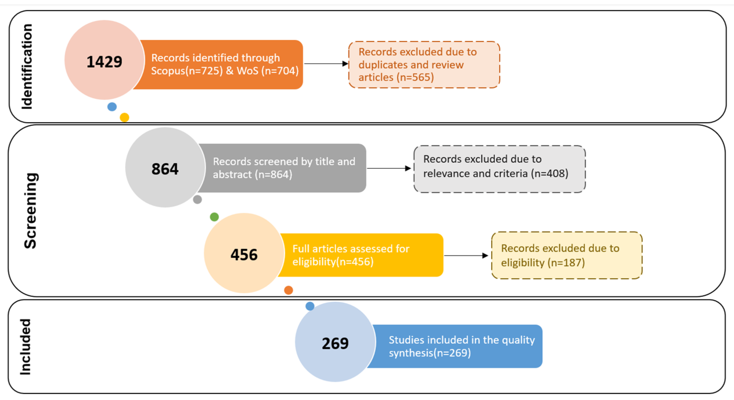
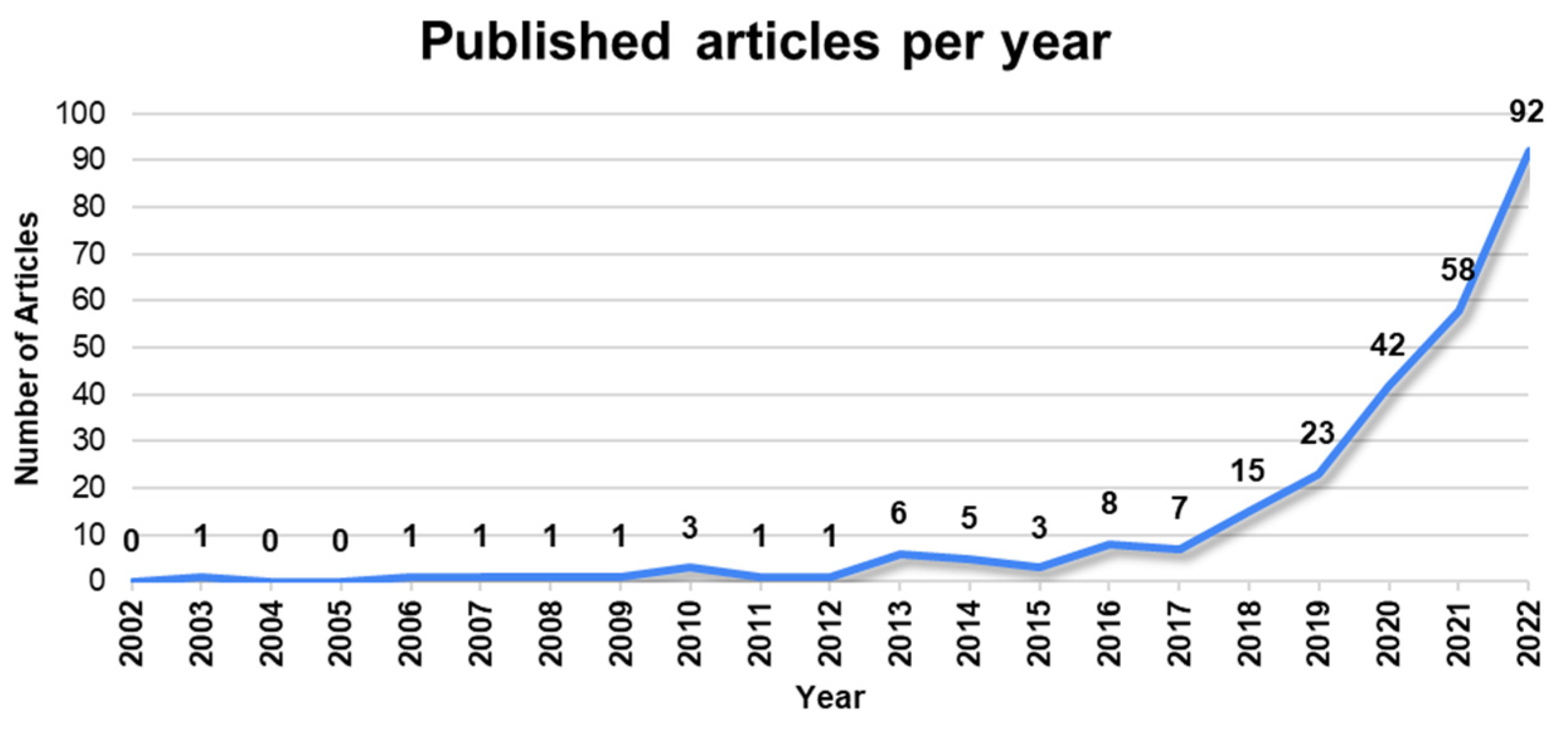

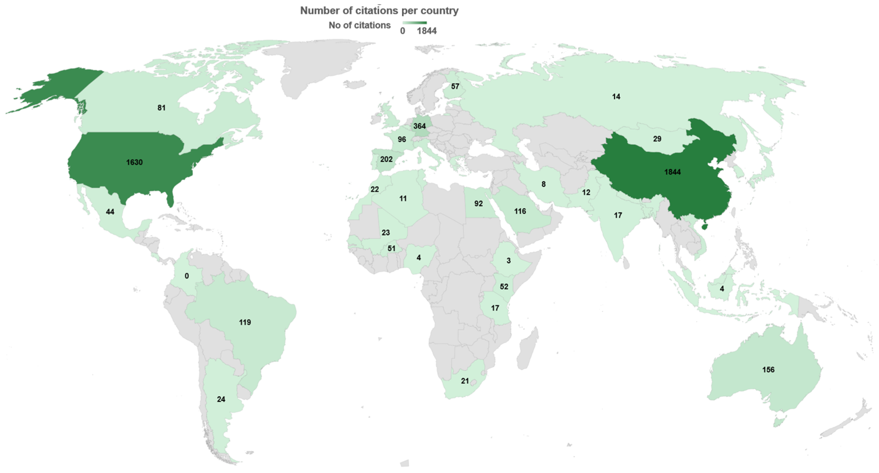

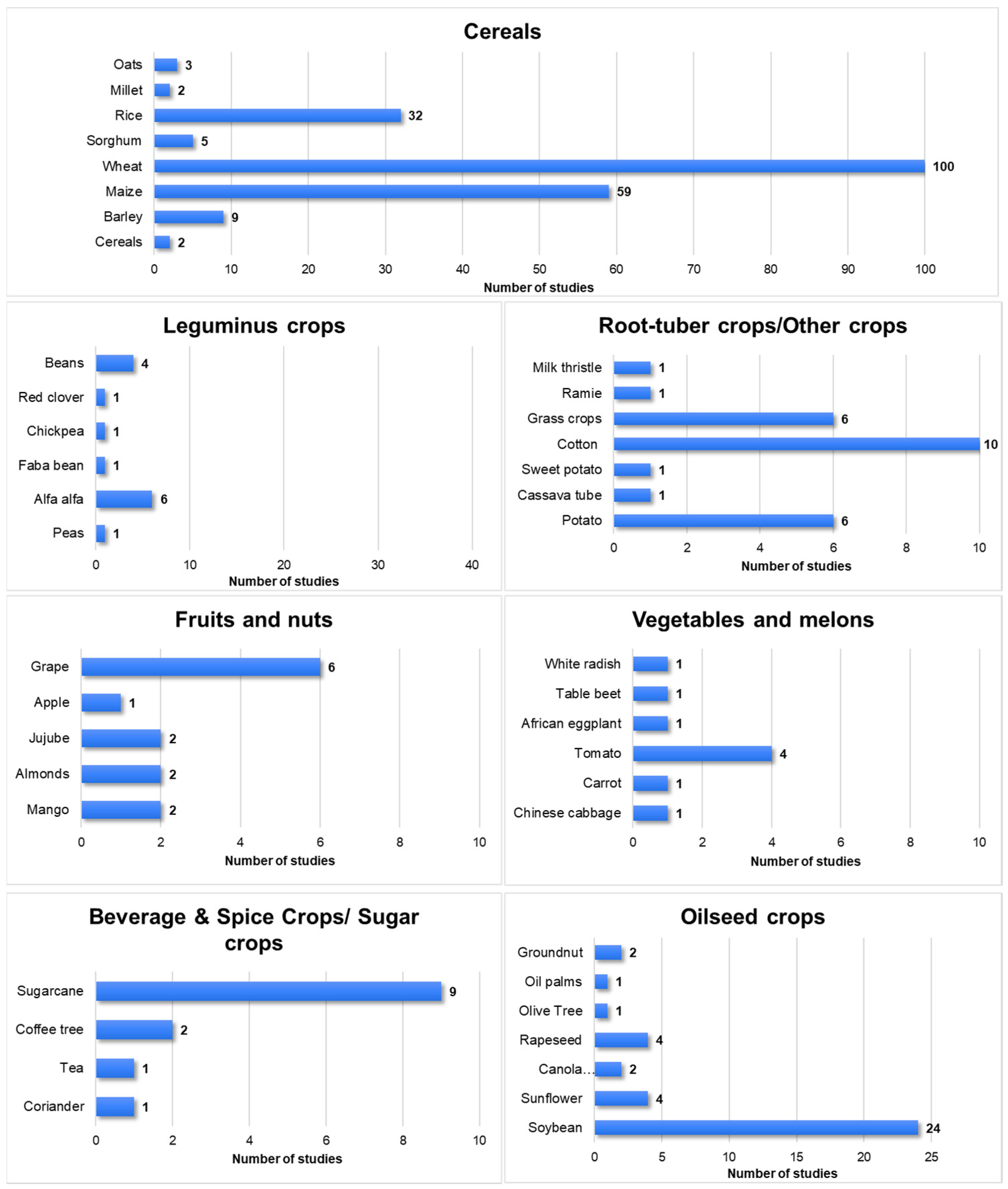
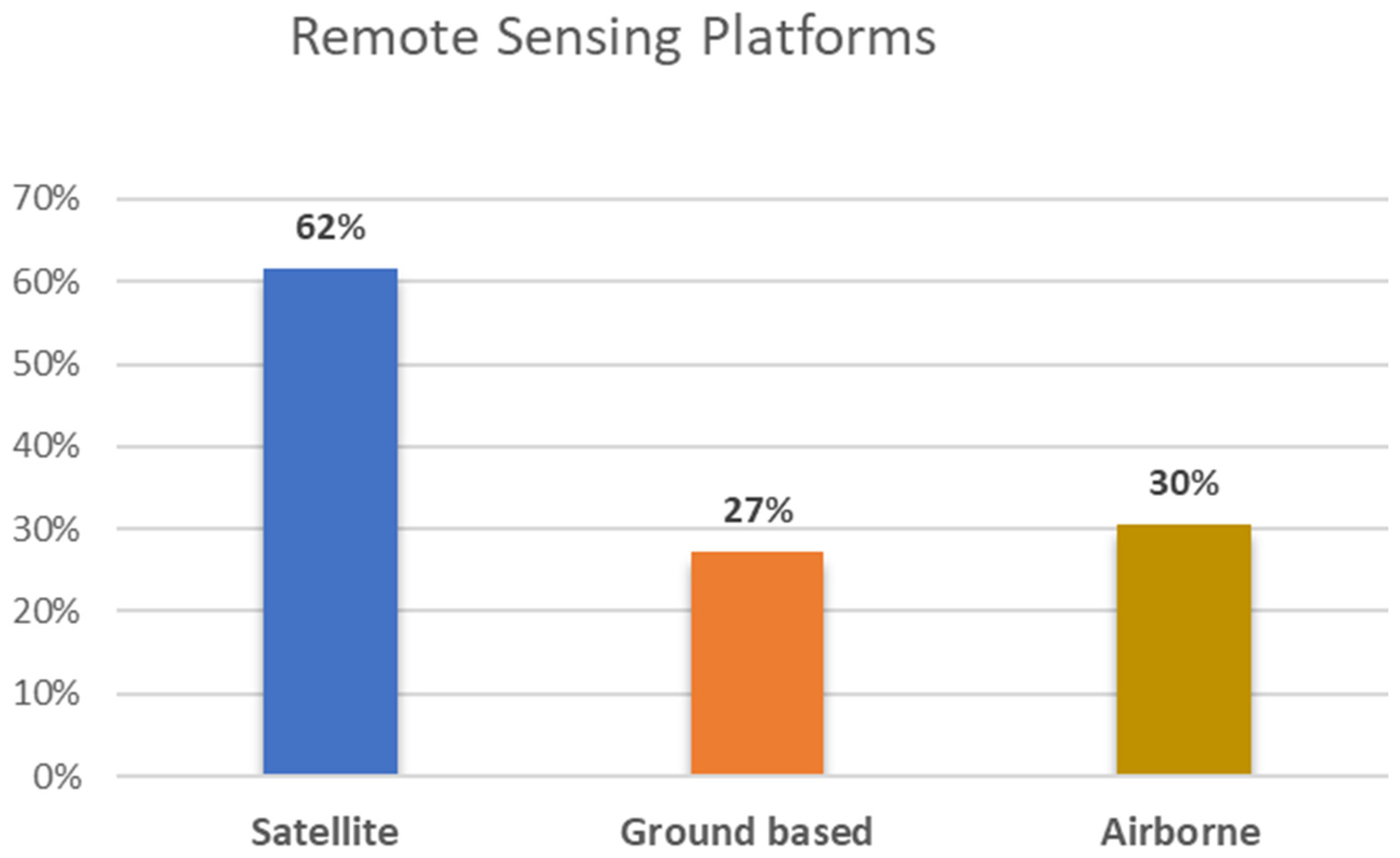
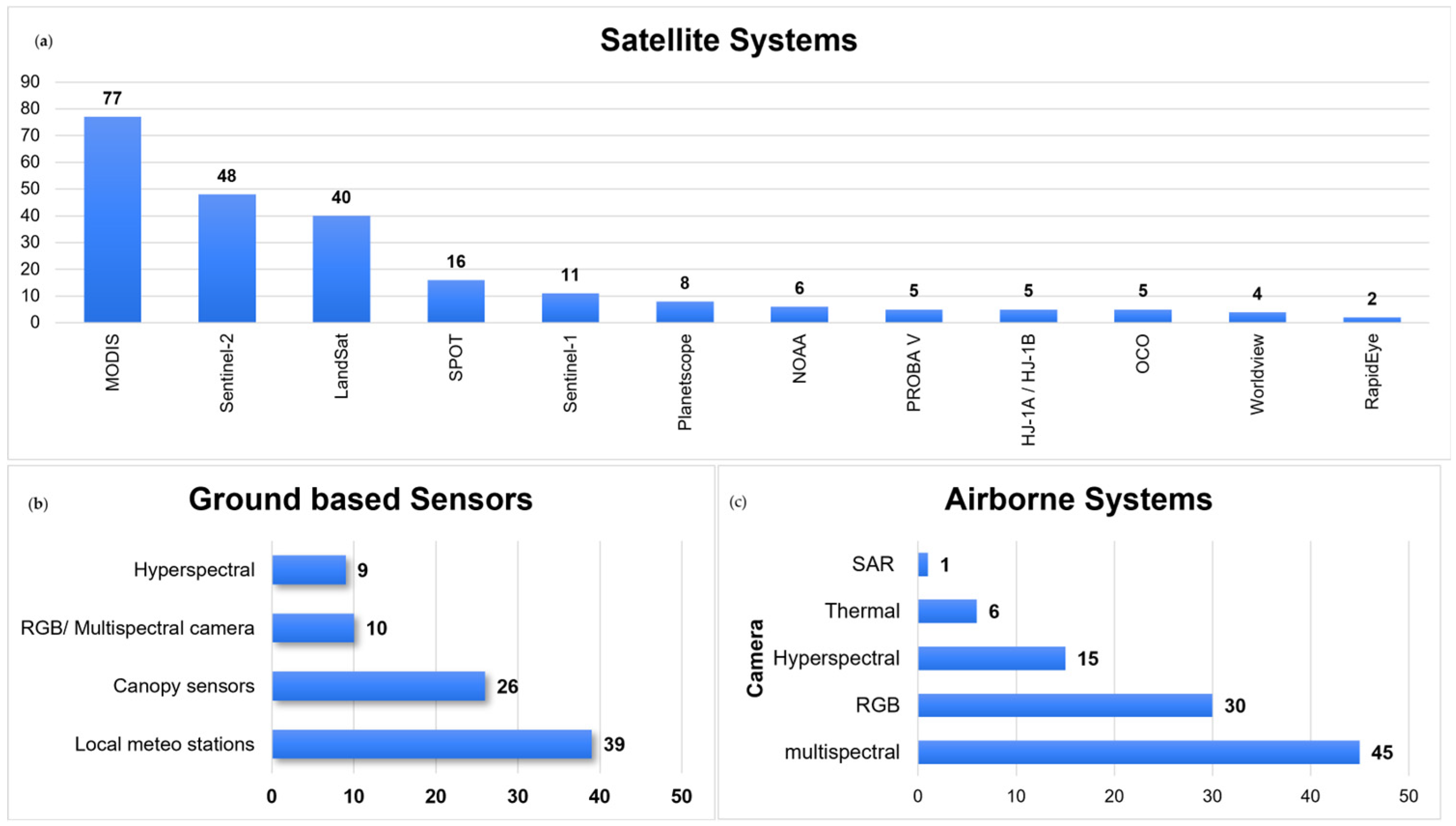

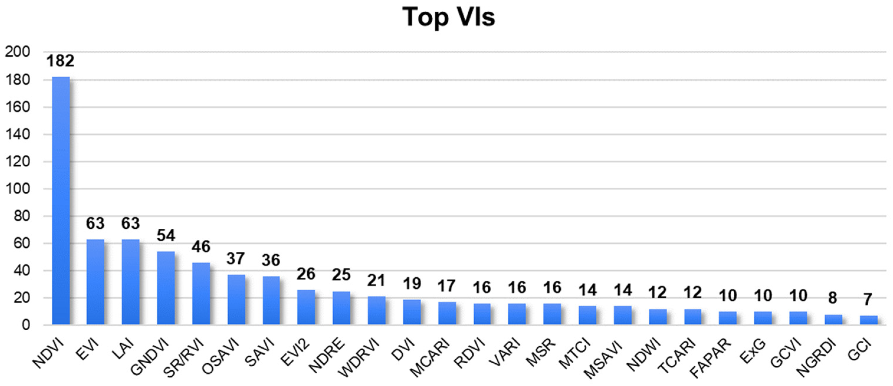
Disclaimer/Publisher’s Note: The statements, opinions and data contained in all publications are solely those of the individual author(s) and contributor(s) and not of MDPI and/or the editor(s). MDPI and/or the editor(s) disclaim responsibility for any injury to people or property resulting from any ideas, methods, instructions or products referred to in the content. |
© 2023 by the authors. Licensee MDPI, Basel, Switzerland. This article is an open access article distributed under the terms and conditions of the Creative Commons Attribution (CC BY) license (https://creativecommons.org/licenses/by/4.0/).