Highlights
What are the main findings?
- In the Gojjam sub-basins, satellite rainfall products capture broad rainfall patterns but exhibit distinct strengths and limitations.
- These products consistently overestimate light rainfall and underestimate heavy rainfall, with systematic errors becoming more dominant as intensity increases.
What are the implications of the main findings?
- Product-specific calibration is required to correct characteristic biases, particularly reducing missed light rainfall in CHIRPS and false alarms in MSWEP/TAMSAT.
- Sub-basin scale evaluation underscores the importance of localized calibration for reliable hydrological modeling and climate assessments in Ethiopia’s complex highland terrain.
Abstract
Satellite-based rainfall products (SRPs) are indispensable for hydro-climatological research, particularly in data-limited environments such as Ethiopia. This study systematically evaluates the performance of three widely used SRPs: Climate Hazards Group InfraRed Precipitation with Station data version 2 (CHIRPS), Tropical Applications of Meteorology using Satellite and ground-based observations version 3.1 (TAMSAT), and Multi-Source Weighted Ensemble Precipitation version 2.8 (MSWEP) across the North and South Gojjam sub-basins of the Abbay Basin. Using ground observations as benchmarks, spatial and temporal accuracy was assessed under varying elevation and rainfall intensity conditions, employing bias decomposition, error analysis, and detection metrics. Results show that rainfall variability in the region is shaped more by the local climate and topography than elevation, with elevation alone proving a weak predictor (R2 < 0.5). Among the products, MSWEP v2.8 demonstrated the highest daily rainfall detection skill (≈ 87–88%), followed by TAMSAT (≈78%), while CHIRPS detected only about half of rainfall events (≈54%) and tended to overestimate no-rain days. MSWEP’s error composition is dominated by low random error (~52%), though it slightly overestimates rainfall and rainy days. TAMSAT provides finer-resolution data that capture localized variability and dry conditions well, with the lowest false alarm rate and moderate random error (~59%). CHIRPS exhibits weaker daily performance, dominated by high random error (~66%) and missed bias, though it improves at monthly scales and better captures heavy and violent rainfall. Seasonally, SRPs reproduce MAM rainfall reasonably well across both sub-basins, but their performance deteriorates markedly in JJAS, particularly in the south. These findings highlight the importance of sub-basin scale analysis and demonstrate that random versus systematic error composition is critical for understanding product reliability. The results provide practical guidance for selecting and calibrating SRPs in mountainous regions, supporting improved water resource management, climate impact assessment, and hydrological modeling in data-scarce environments.
1. Introduction
Rainfall is a fundamental component of the hydrological cycle and a key determinant of basin hydrology, influencing water availability, ecosystem health, and socioeconomic activities [1]. Accurate characterization of the spatial and temporal distributions of rainfall is, therefore, essential for hydrological modeling, water resource management, and climate impact assessments. In particular, hydrological models require high-resolution meteorological data to evaluate the effects of anthropogenic activities and climate change, thereby supporting sustainable decision-making [2].
However, the spatial coverage of meteorological stations in many regions, especially in developing countries such as Ethiopia, remains insufficient to capture the inherent spatiotemporal variability of rainfall. Station densities are rarely achieved in Ethiopia because of the high costs of installation, maintenance challenges, and the complex climate and topography that characterize much of the country [3]. Furthermore, long-term rainfall records necessary for climate change studies are often incomplete or contain gaps caused by instrument failure, measurement errors, and data management issues, which propagate uncertainties in hydrological analyses.
The advent of remote sensing technologies has revolutionized rainfall monitoring by providing satellite-based rainfall products derived from microwave and infrared sensors [4]. These SRPs offer finer spatial and temporal resolutions than traditional gauge networks do and can fill observational gaps, especially in data-scarce regions. Despite providing valuable information, they are constrained by spatial and temporal accuracy issues that depend on terrain complexity, rainfall intensity, and sensor characteristics. These limitations have been demonstrated in practice: for example, ref. [5] reported biases as high as 2700 mm, rendering SRPs unsuitable for direct water balance modeling without correction, while ref. [6] showed in the Beressa watershed that SRPs often miss peak rainfall events and exhibit distinct error patterns that cannot be resolved through simple bias adjustments. Such evidence highlights that the applicability of SRPs is determined by the magnitude of errors or biases, underscoring the need for careful validation and product selection before their use in hydrological or climate applications, with ground-based observations serving as the critical benchmark [6,7].
Extensive global research has validated satellite rainfall products such as MSWEP and CHIRPS across diverse climatic and geographic regions. MSWEP has proven highly reliable across seasons and terrains, excelling in daily climatology and rain-to-no-rain detection in regions such as the Indo-Pak cryosphere and India, though requiring bias correction for short-duration extremes [8,9,10,11]. CHIRPS performs well at monthly scales and in arid to semi-arid highlands, including Yemen, but is less effective for daily extremes [12,13]. Both CHIRPS and MSWEP capture broad rainfall variability in large basins such as the Himalaya, the Yellow River, and Chile, yet face challenges with fine-scale intensity classification [14,15,16].
Across Africa, CHIRPS, MSWEP, and TAMSAT have been widely validated, demonstrating complementary strengths and limitations across regions and scales. CHIRPS captures rainfall gradients and supports flood monitoring in Burkina Faso, while TAMSAT is effective for drought applications; both slightly underestimate rainfall but remain reliable alternatives to sparse gauge data [17,18]. Inter-comparisons over east and southern Africa reveal strong agreement and improving consistency despite terrain challenges, with CHIRPS excelling at decadal and monthly scales and TAMSAT at the daily scale [19]. CHIRPS has proven reliable for drought monitoring and annual rainfall patterns in eastern Africa, though weaker at capturing daily extremes [20,21]. Regional studies highlight terrain sensitivity, with CHIRPS and TAMSAT reliable in Nigerian highlands but prone to rainfall intensity biases [22], MSWEP performing well in Morocco’s Drâa Basin, and CHIRPS showing a tendency of false positives [23].
In Ethiopia’s Abbay Basin, recent studies have evaluated CHIRPS, TAMSAT, and MSWEP, revealing significant spatial and temporal variability in accuracy, with each product showing distinct strengths and limitations [24]. CHIRPS and MSWEP perform better in tropical/subtropical areas, while TAMSAT excels in temperate/alpine regions [25]. Validation across the Upper Blue Nile and other basins emphasized the need to assess satellite estimates before operational use [5,26,27]. Local studies further showed that rainfall regime, season, integration time, and terrain strongly influence accuracy [28]. Despite these limitations, SRPs have been adopted for rainfall variability and trend analysis [29,30,31,32,33], watershed hydrology and water balance modeling [34,35,36,37,38,39,40], and drought monitoring [41,42,43,44,45]. CHIRPS is frequently used for drought monitoring and monthly rainfall estimation [42,45,46], while MSWEP and TAMSAT are more effective for capturing daily rainfall variability [40,47,48,49]. Overall, diverse validation efforts confirm that no single dataset can fully capture Ethiopia’s complex rainfall variability, underscoring the need for systematic validation, local bias correction, and application-specific tailoring [50,51].
Although progress has been made, substantial challenges remain. Most previous studies have focused on broader basin scales, with limited attention given to sub-basin scale heterogeneity. Furthermore, the interaction between elevation and rainfall variability and how this affects satellite product performance has not been fully addressed in these sub-basins. This study addresses these gaps by providing a detailed, sub-basin scale evaluation of CHIRPS, MSWEP, and TAMSAT satellite rainfall products in the North and South Gojjam sub-basins of the Abbay Basin, Ethiopia. This research explores spatial and temporal rainfall patterns and evaluates how accurately satellite products capture these dynamics compared with ground-based observations, especially under varying elevation and rainfall intensity conditions. The objectives include (1) assessing the performance of the selected satellite datasets, (2) analyzing the relationship between elevation and rainfall distribution, and (3) identifying the sources of total bias error and related variability source of error in satellite rainfall estimates. These findings offer valuable guidance for selecting, calibrating, and applying satellite rainfall products in complex mountainous environments.
2. Material and Methods
2.1. Study Area
2.1.1. Location and Elevation
North Gojjam and South Gojjam are two neighboring sub-basins located within the Abay Basin (Upper Blue Nile Basin), one of the largest basins in Ethiopia. Geographically, North Gojjam lies between 10.06° and 11.72° east longitude and 37.23° and 38.53° north latitude, whereas South Gojjam is situated between 9.84° and 11.12° east longitude and between 6.19° and 38.17° north latitude (Figure 1). North Gojjam encompasses parts of East Gojjam, West Gojjam, and South Gondar Zones, whereas South Gojjam covers portions of East Gojjam, West Gojjam, and Agew Zones.
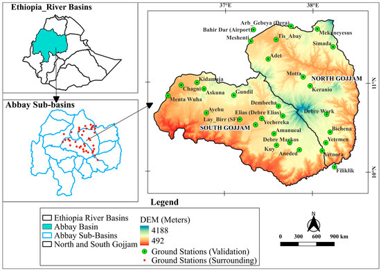
Figure 1.
Ethiopia’s Abbay River Basin highlighting the North and South Gojjam sub-basins, surrounding ground stations, selected validation sites, and the digital elevation model (DEM) of the two sub-basins.
In terms of area, South Gojjam is larger, covering approximately 16,762.3 km2, which is approximately 2372.8 km2 greater than North Gojjam’s 14,389.5 km2. The elevation in these sub-basins varies considerably. North Gojjam reaches a maximum elevation of 4112 m, which is slightly higher than South Gojjam’s maximum elevation of 3976 m. The mountainous area known as the Choke Mountain, which marks the boundary between the two sub-basins, contains the highest elevations in both regions. The mean elevation is higher in North Gojjam at 2248.6 m than in South Gojjam at 1968 m. However, South Gojjam has greater elevation variability, with a standard deviation of 505.6 m, surpassing North Gojjam’s standard deviation of 474 m.
2.1.2. Rainfall, Land Use and Agro-Ecology
The rainfall patterns in both the North and South Gojjam sub-basins exhibit a single peak, with the main rainy season occurring from June to September (JJAS). In the northern sub-basin, the annual rainfall ranges from 810 to 1815 mm, with lower amounts recorded in the western and southern areas and higher rainfall concentrated in the highland regions. In contrast, the southern sub-basin receives between 845 and 2030 mm of rainfall annually, with the southeastern part experiencing lower rainfall and the northern areas receiving higher amounts [52]. Notably, rainfall variability is greater across stations in the southern sub-basin, where both the peak timing and rainfall amounts tend to be greater than those in the northern basin (Figure 2).
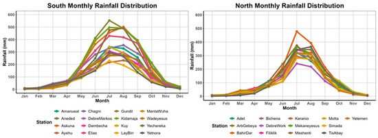
Figure 2.
Seasonal rainfall patterns and variability from January to December across all stations.
With respect to land use, data from the European Space Agency’s (ESA) World Cover 10 m v200 dataset indicate that agriculture (cropland) is the dominant land cover in both sub-basins (Figure 3). However, the southern sub-basin has a greater proportion of tree cover, whereas the northern sub-basin features more grassland and shrub land (Table 1).
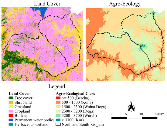
Figure 3.
Map of agro-ecological classes and land use patterns within the study area.

Table 1.
Land use class percent coverage for each sub-basin.
Following the Atlas of the Ethiopian Rural Economy [53] that traditionally classified the country using the elevation range to differentiate the Agro-Ecological Zone (AEZ), the study basins classified (Figure 3) using a digital elevation model (DEM) 30 m resolution of the Shuttle Radar Topography Mission (SRTM) datasets from a United States geological survey (USGS) https://earthexplorer.usgs.gov/ (accessed on 19 December 2021). North Gojjam is dominated by middle-altitude to highland zones (Woina Dega and Dega), whereas South Gojjam has more lowland (Kolla) and middle-altitude areas.
2.2. Data Sources
2.2.1. Ground Station Data
Ground station data from Ethiopia’s National Meteorological Agency (NMA) were used to validate satellite rainfall estimates. The validation period was chosen based on data availability, focusing on years with the most complete records. Stations with observations spanning 2009–2018 were included, totaling 29 sites: 16 in the South Gojjam sub-basin and 13 in the North Gojjam sub-basin. Stations with more than 20% missing data were excluded from the analysis.
Data Quality Control and Processing
Meteorological datasets often contain gaps due to instrument failure, limited access, or recording errors, which can bias conclusions. Missing values were filled using the normal ratio method, drawing on data from nearby stations with strong correlations. Outliers were identified with the Climate Data Tool (CDT) and confirmed through a visual inspection of time-series plots. Verified outliers were corrected using the maximum rainfall recorded for the same day and month at each station. Data visualization was performed in R Studio 2025.05.0 and Excel, while maps were produced in QGIS 3.34.10.
2.2.2. Satellite Rainfall Products (SRPs)
Satellite rainfall products are indispensable for monitoring precipitation in regions with sparse and unevenly distributed ground observations. Among these, TAMSAT v3.1, CHIRPS v2.0, and MSWEP v2.8 are widely utilized due to their extensive temporal coverage and methodological diversity. In this study, the performance of each product was assessed using its native spatial resolution to avoid uncertainties associated with re-gridding and re-sampling.
TAMSAT v3.1
TAMSAT is a satellite-based rainfall product designed primarily for Africa, utilizing thermal infrared data from Meteosat satellites. It estimates rainfall by detecting cold cloud tops associated with precipitating storm systems using the Cold Cloud Duration (CCD) method, calibrated with pentad rain gauge data. The product offers high spatial resolution at approximately 0.0375 degrees equivalent to about 4 km and provides rainfall estimates at daily and pentad time scales from 1983 to the near present [54]. TAMSAT v3.1 features enhanced accuracy and spatial consistency compared to earlier versions, making it effective for capturing rainfall variability.
CHIRPS v2.0
CHIRPS is a thermal infrared rainfall product that estimates precipitation from global CCD data. It is calibrated using the Tropical Rainfall Measuring Mission (TRMM) 3B42 version 7 data and corrected with gauge information from the World Meteorological Organization’s (WMO) Global Telecommunication System (GTS), the Global Historical Climatology Network (GHCN), the Global Summary of the Day (GSOD), the Southern African Science Service Centre for Climate Change and Adaptive Land Management (SASSCAL), and national meteorological agencies. CHIRPS offers a spatial resolution of approximately 0.05 degrees, equivalent to about 5 km, and provides a long historical record from 1981 up to near present. This product mainly covers land areas between 50 degrees south and 50 degrees north latitude [55].
MSWEP v2.8
MSWEP is a global merged precipitation dataset that integrates satellite observations, ground-based rain gauges, and atmospheric reanalysis data to produce gauge-corrected daily rainfall estimates at a 0.1-degree spatial resolution equivalent to about 10 km. It utilizes diverse inputs, including microwave and infrared satellite data, to enhance accuracy and coverage. It offers three-hourly, daily, and monthly rainfall data from 1979 to 2020 [56]. For this study, the gauge-corrected dataset was used.
2.3. SRPs Performance Validation and Metrics
The pixel-to-point approach was used to validate SRPs, as it is the most appropriate in regions with sparse ground station networks where pixel-to-pixel comparisons may introduce bias. Spatial comparisons were carried out to evaluate consistency among SRPs. Because of the limited number of stations, no interpolation was applied; instead, rainfall gradients (increasing and decreasing patterns) were examined and cross-checked against previous study findings and the mean annual point rainfall distribution from existing stations. In addition, a 10-year mean annual bias relative to ground observations was calculated to assess the overall magnitude and direction of bias agreement among SRPs.
Rainfall detection was assessed at the daily scale using event based classification (Table 2), where hits, misses, false alarms, and correct negatives were identified according to a rain/no rain threshold of ≥1 mm/day. These daily comparisons provided the basis for evaluating SRPs’ ability to capture rainfall occurrence, with performance measured using occurrence based metrics (Table 3).
Table 2.
Rain-to-no-rain classification criteria for satellites and ground stations.
Table 3.
Satellite rainfall estimate performance metrics.
Rainfall totals were evaluated at daily, monthly, and seasonal scales, with totals assessed using statistical metrics (Table 3). Seasonal aggregates were examined with particular focus on the Abbay Basin’s key rainfall periods: JJAS (June–September), which contributes the majority of annual precipitation, and MAM (March–May), which provides critical early rains. Additionally, rainfall representation was examined by comparing SRPs with ground station observations in terms of variability and totals, where statistical measures (Table 3) were applied to evaluate mean values and dispersions.
2.4. Distribution of Rainfall Frequency and Intensity Categories
Rainfall events were classified into intensity categories: no rain, <1 mm/day; light rain, 1–10 mm/day; moderate, 10–20 mm/day; heavy, 20–40 mm/day; violent, ≥40 mm/day. These categories were used to validate SRPs performance across intensity [65,66,67]. Rainfall frequency within each category was calculated by dividing the number of events in that class to the total number of observations. Moreover, rainfall contribution of each intensity class was assessed by dividing the total rainfall in each category by the overall rainfall sum. This analysis provided insights into the rainfall characteristics of each sub-basin and the ability of SRPs to represent both frequency and intensity distributions. Finally, for each class, the probability of detection (POD; Table 3) was calculated together with hit bias, missed bias, false bias, and random error.
2.5. Application of Bias Decomposition in Satellite Rainfall Estimates
- Error component decomposition
Total bias was decomposed into hit bias, miss bias, and false bias following the approach of [68], which prevents the cancelation of opposing errors and reveals the true sources of discrepancy in satellite rainfall estimates. However, this approach suffers from the limitation of magnitude simplification, as all detected rainfall errors are aggregated into a single hit bias, which obscures differences between underestimation and overestimation across rainfall intensities. Recent studies have attempted to address this limitation [69] improved the scheme by disaggregating hit bias into over-hit and under-hit, thereby better capturing intensity errors. More recently, ref. [70] proposed a new event-based scheme that decomposes bias into ten components, explicitly accounting for occurrence, timing, and intensity errors. In this study bias decomposition across rainfall intensity categories (light, moderate, heavy, very heavy) were applied to address magnitude simplification and reveals systematic biases within specific intensity ranges.
The daily total bias was decomposed to those three components, as demonstrated by [71]. Hit, missed, and false biases were calculated using Equations (1)–(3), respectively, by dividing the total of each component by the overall sum of daily rainfall recorded at ground stations.
where is the Satellite rainfall estimate for day i, is the Ground station rainfall measurement for day i, and n the total number of daily data pairs (the number of days being compared).
- 2.
- Mean square error decomposition
The mean squared error (MSE) decomposition method, introduced by [72], separates error into systematic (Es) and random (Er) components. This approach has been widely applied to evaluate satellite precipitation estimates, addressing the limitations of single-error measures [71,73]. In this study, it is used to assess the error components of SRPs and their regional differences. Similarly to the error component decomposition, mean square error was also performed for each rain event category.
Decomposition of MSE: It can be decomposed into systematic error and random error. Formally, the decomposition is expressed as:
Es: → difference between the fitted satellite estimate and ground truth.
Er: → difference between the actual satellite estimate and its fitted value.
Linear Fit for Systematic Component:
where Er is the random error, Es systematic error, fitted satellite rainfall estimate, a slope and b intercept, Satellite rainfall estimate for day i, Ground station rainfall measurement for day i, and n the total number of daily data pairs (the number of days being compared).
2.6. Elevation-Dependent Variations
The elevation influences were examined to evaluate the performance of SRPs across different elevations. To identify elevation related trends, the coefficient of determination (R2) between elevation and rainfall was calculated following the approach of [74]. Point values were extracted from each grid cell across the basins to establish elevation–rainfall relationships. In addition, correlations were computed between evaluation metric values (such as bias, RMSE, and correlation coefficient) and the corresponding station elevations to assess how SRPs accuracy varied with terrain. As demonstrated in [74], products whose accuracy improves with elevation tend to perform better than those whose accuracy deteriorates with elevation. This rationale guided our analysis, while our procedure allowed us to quantify both direct and indirect impacts of elevation on rainfall estimates and error characteristics.
2.7. Comparative Statistical Testing of Satellite Rainfall Products
Because rainfall metrics are often non-normal and sample sizes vary across sub-basins, robust statistical procedures were applied to avoid spurious differences. Two objectives guided the analysis: (i) within-region product comparisons across multiple metrics, and (ii) cross-region consistency of satellite estimates.
Confidence Intervals
- Bootstrap CIs: For product pair differences, using percentile bounds (2.5th–97.5th) from resampling.
- T-based CIs: For individual metrics (e.g., RMSE, R2, and POD) based on Student’s t-distribution.
Within-Region Comparisons
Paired product comparisons (CHIRPS vs. TAMSAT, CHIRPS vs. MSWEP, TAMSAT vs. MSWEP) employed bootstrap resampling, Wilcoxon signed-rank tests, and Holm correction.
- (H_0): Mean difference = 0 (no difference)
- (H_1): Mean difference ≠ 0 (products differ)
Cross-Region Consistency
Performance between the North and the South was tested using Welch’s t-test (for unequal variances and sample sizes) [75] and the Wilcoxon rank-sum (Mann–Whitney) test [76,77].
- (H_0): Metrics equal/same distribution across regions
- (H_1): Metrics differ across regions
3. Results and Discussion
3.1. Spatial Comparison and Annual Bias of SRPs
Ground station data (Figure 4) show that five stations in the South Gojjam sub-basin recorded high annual rainfall totals exceeding 1700 mm, while no stations in the North Gojjam sub-basin reached this level despite sharing similar agro-ecological conditions. Elevation differences may partly explain this variation: North Gojjam ranges from 1030 to 4090 m a.s.l., with highlands between 2800 and 4090 m, whereas South Gojjam spans 725 to 3930 m, with highlands between 2200 and 3930 m. Interestingly, despite its higher elevation, North Gojjam recorded maximum annual rainfall between 1300 and 1535 mm, compared to 2000 to 2500 mm in South Gojjam. These discrepancies suggest that rainfall distribution does not strictly follow elevation gradients, reinforcing the view that elevation alone does not determine rainfall amounts [47,58].
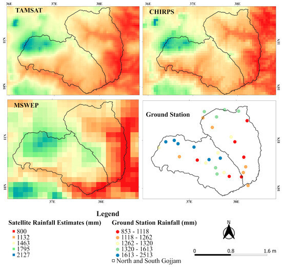
Figure 4.
Spatial representation of mean annual rainfall from satellite rainfall products (gridded) and ground station observations (point data), based on 2009–2018 averages.
As shown spatially in Figure 4, the CHIRPS and TAMSAT satellite products exhibited similar rainfall distribution patterns, highlighting high rainfall over the highest mountain range above 3700 m (Kur). In contrast, MSWEP displayed more pronounced rainfall in this elevated peak (Choke Mountain). All satellite products consistently indicated relatively high rainfall over the northern highlands of the South Gojjam sub-basin, aligning with [52], who reported rainfall exceeding 1400 mm in this region. Overall, the satellite estimates effectively captured the general spatial pattern reported by [52]: lower rainfall in the southeastern part and higher rainfall in the northern part of South Gojjam, as well as reduced rainfall in the western and southern areas and increased rainfall in the highland zones of North Gojjam despite some differences in absolute rainfall amounts.
The relative bias distribution analysis revealed consistent agreement in both the direction and magnitude of bias at 23 out of 29 stations. Specifically, 12 stations showed overestimation, while 11 stations exhibited underestimation. Among the remaining six stations, TAMSAT and CHIRPS agreed in bias direction at four locations. This spatial consistency aligns with findings by [59], who reported that MSWEP and CHIRPS generally exhibit similar bias patterns across Ethiopia’s agro-ecological zone except for the temperate zone. Likewise, ref. [26] found that TAMSAT version 3 performs comparably to CHIRPS in capturing long-term climatological patterns.
The relative bias analysis revealed mixed under- and overestimation across stations without evident link with elevation however, South Gojjam presented a greater bias range than North Gojjam did. On average, MSWEP had a +2% bias in both sub-basins, TAMSAT +0.1 to 3%, and CHIRPS −0.1 to −4.4% for South and North, respectively.
3.2. Performance of SRPs in Capturing and Representing Rainfall Variability
As indicated in Table 4, when annual rainfall statistics from both study basins are combined into a single dataset, the resulting mean and standard deviation are lower than those calculated for the South sub-basin alone, which suggests that a lumped evaluation may obscure important local differences and potentially mislead the final conclusions and selection of SRPs. Rainfall in the South is more variable than that in the North, and satellite rainfall estimates tend to align more closely with the less variable North basin, indicating that SRPs generally perform better in areas with lower rainfall variability.
Table 4.
Summary statistics of gauge observations and SRPs for rainfall variability analysis (mean, SD, CV).
When individual SRPs are compared, TAMSAT consistently has higher mean and standard deviation values than the other products do, especially for the annual mean in both the lumped and separate basin analyses, reflecting its tendency to capture greater rainfall variability (Table 4). In the North sub-basin, MSWEP provides rainfall estimates closest to ground station observations. The other products also perform well, where CHIRPS underestimates variability by approximately 2% and TAMSAT overestimates it by 2%. However, in the southern sub-basins, all the SRPs underestimate rainfall variability, with CHIRPS and TAMSAT underestimating by approximately 13%, and MSWEP performs the worst, underestimating variability by approximately 20%. The consistent underestimation of variability in South Gojjam by all the SRPs points to challenges related to complex terrain or rainfall patterns.
Figure 5 demonstrates that satellite-derived data effectively reproduce the general rainfall pattern, especially capturing the peak amounts observed during the main rainy season. The 95% CI shows that south stations have wider true mean than north, indicating more variable estimates than stable ones in the north. However, relying only on the mean rainfall can overlook important local variations and the ability of SRPs to detect extreme events. To address this, the standard deviation was also analyzed to assess how well SRPs capture local variability. The findings show significant discrepancies in standard deviation during the rainy season in both sub-basins. SRPs are more effective at capturing rainfall variability in the North than in the South, which may be due to the more stable pattern of rainfall in that sub-basin. When specific products are compared, MSWEP is the least effective at capturing variability in both sub-basins.
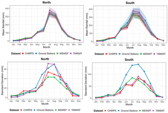
Figure 5.
Mean (with 95% confidence intervals) and standard deviation of rainfall compared with satellite rainfall estimates.
3.3. Rainfall Total Detection Capability
Figure 6 illustrates the evaluation of daily rainfall detection across the two sub-basins. MSWEP performs the best overall, showing the highest correlation (0.51), the lowest errors (MAE 3.5 mm, RMSE 7 mm), and superior efficiency (mean NSE = 0.15). TAMSAT follows with moderate correlation (0.47), errors (MAE 3.7 mm), and efficiency (0.05). CHIRPS performs the poorest, with the lowest correlation (0.37), the highest errors (MAE 4.3 mm), and predominantly negative efficiency values.
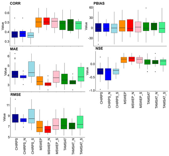
Figure 6.
Statistical metrics for daily rainfall validation, with S for South Gojjam, N for North Gojjam, and un-suffixed metrics showing combined performance.
Pairwise comparisons further confirm that MSWEP consistently outperforms CHIRPS and TAMSAT across most performance dimensions. Significant differences were observed in correlation, error magnitudes (MAE, RMSE), and efficiency (NSE) in both sub-basins (Supplementary Table S2). Bias (PBIAS) differences were not consistently significant, particularly in the northern region, although CHIRPS tended to underestimate rainfall more strongly in the south.
Cross-region comparisons revealed that all products exhibited significantly higher mean absolute error in the south, indicating better performance in the north (Supplementary Table S3). Other metrics showed no consistent regional differences. In North Gojjam, all products tended to overestimate rainfall, with relatively stable and consistent performance metrics; MSWEP in particular demonstrated a pronounced positive bias. In the southern sub-basins, MSWEP continued to overestimate rainfall on average, whereas both TAMSAT and CHIRPS generally underestimated it. In South Gojjam, conditions proved more challenging, with larger biases overall. Here, the satellite products showed both significant underestimations and overestimations, reflecting the complex terrain and meteorological factors influencing rainfall measurements.
The literature supports these patterns. Several studies report a general underestimation of CHIRPS rainfall [28,58,61], although localized overestimation has been noted in the central highlands of the Abbay basin [24]. Both CHIRPS and TAMSAT have been found to overestimate rainfall in low-elevation zones but underestimate it at higher elevations within South Gojjam [48]. Similarly, ref. [78] highlighted a general underestimation by both products in the Gumara watershed. TAMSAT has also been reported to underestimate rainfall by about 30% over the Blue Nile basin [5]. MSWEP, on the other hand, tends to overestimate rainfall in most zones but underestimates it in alpine areas [25]. Overall, CHIRPS mostly underestimates rainfall, TAMSAT shows mixed biases depending on elevation and climate zone, and MSWEP generally overestimates except in alpine regions, consistent with the regional differences observed in this study.
3.4. Rainfall Occurrence Detection Capability
The POD is highest for the MSWEP, averaging 87% across the study area, with 90% in the southern basin and 84% in the northern basin. TAMSAT follows with a mean POD of 78% (81% South, 75% North), whereas CHIRPS detects only 54% of rainfall events (56% South, 51% North) (Figure 7). This aligns with a study in the Lake Tana Basin, where TAMSAT outperforms (with a POD of 85% on average) CHIRPS, which misses 40–45% of rainfall events [28]; similarly, ref. [24] observed this pattern of low detection capability (55%) by CHIRPS in highland regions of the Abbay Basin. However, in certain agro-ecological zones, CHIRPS shows higher POD (67–89%), comparable to TAMSAT and MSWEP [25].
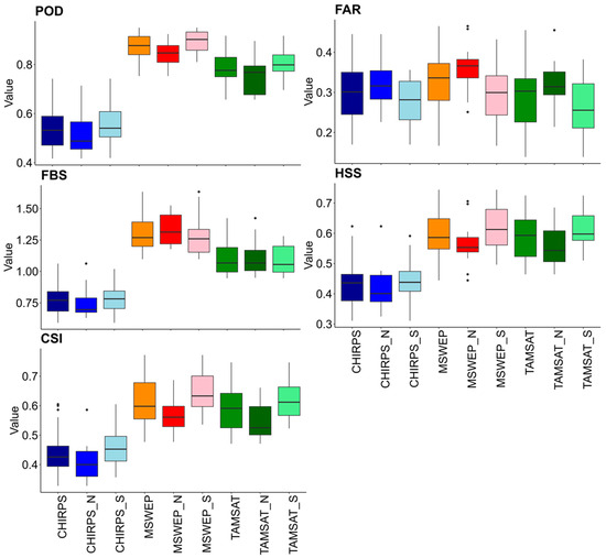
Figure 7.
Categorical metrics for daily rainfall validation, with S for South Gojjam, N for North Gojjam, and un-suffixedmetrics showing combined performance.
The FAR is relatively high for all products, TAMSAT has the lowest mean FAR of 29%, followed by CHIRPS at 30%, and MSWEP has the highest FAR at 33%. The FBS indicates that MSWEP and TAMSAT tend to overestimate rainy days, with MSWEP’s station level FBS reaching 1.6, indicating a stronger overestimation. Conversely, CHIRPS underestimates rainy days, with an FBS of 0.77 on average. The southern basin consistently has lower FBS values than the northern basin does. The higher FAR of MSWEP corresponds to its significant overestimation of rainfall frequency. This trend of overestimation of rainy days and underestimation by TAMSAT and CHIRPS, respectively, was reported in a study in the Blue Nile Basin [28]. MSWEP version 2.2 was observed to often overestimate the number of rainfall days, whereas CHIRPS tends to underestimate the frequency of rainy days [27].
The HSSs reflect similar patterns: MSWEP and TAMSAT perform comparably well, with scores of approximately 60% across the study area, whereas the CHIRPS scores are lower, at approximately 43%. TAMSAT is outperformed by MSWEP by approximately 1%, following the same regional trends. The overall detection shows better result for the South basin than in the North basin across all the metrics and products.
Pairwise comparisons revealed that MSWEP consistently outperformed CHIRPS and TAMSAT in detection. Also, significant differences were observed in POD, FBS, CSI, and HSS in both sub-basins (Supplementary Table S2). For HSS, CHIRPS consistently exhibited significantly lower skill than both MSWEP and TAMSAT in both regions, confirming its weaker detection capability. By contrast, differences between TAMSAT and MSWEP were not significant, indicating comparable HSS performance between those two products. FAR did not show significant differences, suggesting comparable performance among products. Cross-region comparisons revealed that TAMSAT and MSWEP also showed significant regional differences in detection skill, with lower POD, CSI, and HSS and higher FAR in the north (Supplementary Table S3). CHIRPS did not show significant detection differences, only borderline trends in FAR and CSI.
3.5. Rainfall Intensity and Frequency Representation for SRPs
The frequency distribution by rainfall intensity class indicates (Figure 8) that TAMSAT aligns most closely with ground observations compared to CHIRPS and MSWEP. CHIRPS tends to overestimate the occurrence of no-rain days and underestimate light rainfalls, while MSWEP shows the opposite. CHIRPS is, however, capable of detecting heavy and violent rainfall intensities, whereas TAMSAT exhibits the highest skill in identifying dry days.
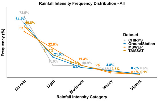
Figure 8.
Comparison of rainfall frequency from satellite estimates and ground stations across intensity classes (all stations).
A heat map of rainfall rate contributions reveals similar pattern of precipitation between the South and North sub-basins (Figure 9). A comparison of the SRPs against the gauge data revealed that all the products tended to overestimate moderate rainfall contributions in both basins. Light rainfall is overestimated by MSWEP and TAMSAT but underestimated by CHIRPS; however, heavy rainfall is underestimated by MSWEP and TAMSAT. Violent rainfall occurrences are minimal in MSWEP and TAMSAT, with CHIRPS underestimating heavy and violent events but performing closer to gauge observations within a 1–3% margin. This is also evident from the frequency plot (Figure 9), as well; [78] reported better performance in high-rainfall categories. Notably, no rainfall contributions appear at approximately 1% in either region; however, only MSWEP showed 1.5% in the south and 2% in the north, implying a higher prevalence of no-rain conditions detected by MSWEP, indicative of a drizzling effect.
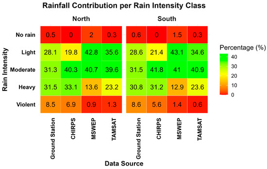
Figure 9.
Rainfall contribution per intensity class: satellite rainfall products versus ground stations (heat map representation).
3.6. Observed Bias Components and Error Patterns in Satellite Rainfall Estimates
The overall hit bias analysis of SRPs indicates that MSWEP underestimates rainfall by about 14%, TAMSAT by 6%, while CHIRPS overestimates by 14% (Figure 10). Missed bias was detected highest for CHIRPS (38%), moderate for TAMSAT (15%), and the lowest for MSWEP (8%). False bias values were similar across sub-basins (23–24%). At the sub-basin level, performance was generally consistent, though false bias distributions were more variable in the South and more compact in the North. Hit bias patterns were stable across products, with CHIRPS showing higher mean values, while missed bias tended to be greater in the South for all SRPs.
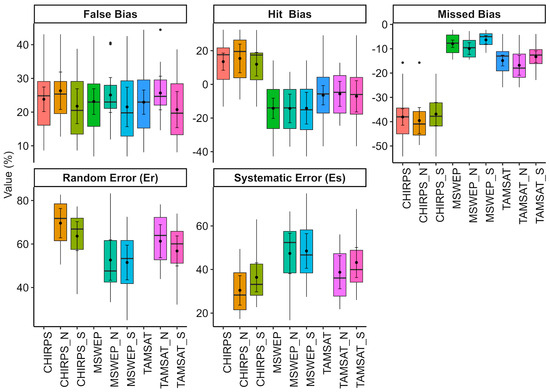
Figure 10.
Error decomposition in satellite rainfall products for North (N) and South (S) Gojjam with 95% Confidence Intervals.
Pairwise analyses (Supplementary Table S4) confirmed significant differences in hit bias among products; however, because hit bias is aggregated across the time series, these mean differences do not directly reflect detection skill, and no product can be deemed definitively superior for hits. In contrast, missed bias results were more conclusive: CHIRPS consistently exhibited the largest missed bias, MSWEP the smallest, and TAMSAT intermediate, with differences statistically significant in both sub-basins. False bias differences were small and not consistently significant, indicating broadly similar false alarm rates. Cross-region comparisons showed that CHIRPS and TAMSAT performed similarly between North and South, with no significant variation, while MSWEP displayed a significant regional effect in missed bias, with the North sub-basin missing more events than the South. For hit and false bias, no product showed consistent regional differences (Supplementary Table S5).
These findings are consistent with those reported for the Upper Tekeze Basin by [79], where CHIRPS exhibited an overestimated hit bias along with a relatively higher missed bias during the wet season. Over the Lake Tana Basin, both false rains and missed rains were found to contribute substantially to the overall rainfall bias for CMORPH [80]. Global analysis has found that hit bias and false errors are the major contributors to the total bias for most areas of the world [71]. Here in this study, for TAMSAT and MSWEP, false bias was generally the dominant source; however, at certain stations, hit bias emerged as the primary contributor, indicating that both factors play a role. In contrast, for CHIRPS, the bias was mainly driven by missed rainfall events, with false rains also contributing to some extent.
The mean square error (MSE) decomposition analysis revealed distinct error structures across the satellite rainfall products. CHIRPS exhibited the highest proportion of random error (66%), with systematic error accounting for 34% and a relatively wide range of 33%. TAMSAT followed with 59% random error and 41% systematic error, accompanied by a moderate range of 18%. In contrast, MSWEP demonstrated the lowest random error contribution (52%) and the highest systematic component (48%), with a narrow range of only 4%, indicating greater consistency (Figure 10). Overall, random error was found to be the major component of the total mean squared error, consistent with global findings reported by [71]. Additionally, pairwise analyses across products (Supplementary Table S6) reveal a consistent ranking of product performance. Random error (Er) was found to be higher for CHIRPS than both TAMSAT and MSWEP, while TAMSAT was also higher than MSWEP (Supplementary Table S6) with no significant regional difference.
3.7. Bias (Error) Decomposition Across Rainfall Intensity Categories
Table 5 indicates that the POD generally increases with rising rainfall intensity, from light to violent, across most satellite products. An exception is TAMSAT, which shows no improvement in POD during violent rainfall events. In addition, the missed bias tends to decrease as rainfall intensity increases, suggesting greater accuracy in detecting heavier rainfall and likely reflecting the reduced number of detectable events at higher intensities. Similar findings were reported in [68], where satellite rainfall products performed well in identifying strong precipitation events, though challenges remain in accurately capturing rainfall amplitudes and in consistently missed light rainfall events.
Table 5.
Probability of Detection (POD) and error decomposition of satellite rainfall estimates across intensity classes.
For no-rain conditions, CHIRPS and TAMSAT stand out with notably high POD values of 96 and 90, respectively, indicating strong performance in identifying dry days. In contrast, MSWEP exhibits a more gradual improvement in POD across varying rainfall intensities. Supporting evidence includes [5], who reported a high detection rate of 91 for very light rainfall (<0.1 mm) by TAMSAT in the Upper Blue Nile Basin, and ref. [65], who reported a median POD for no rain between 0.89 and 0.91 for TAMSAT in the Awash River Basin. Multiple studies have confirmed that satellite rainfall products exhibit strong ability to distinguish rain-to-no-rain events, with particular strength in identifying dry conditions [9,27,50,78].
The error decomposition of hit bias across rainfall intensity classes indicates that SRPs consistently overestimate light rainfall events, while underestimating rainfall at higher intensities, with the degree of underestimation increasing in the extreme categories. Random error decreases as intensity rises, meaning that systematic error becomes the dominant contributor at extreme rainfall levels. Similar findings were reported in [71], which highlighted large proportions of systematic error and underestimation of precipitation volumes in events exceeding 40 mm/day, and in [73], which showed that systematic error increases with the rain rate.
In Ethiopia, consistent patterns have been observed: rainfall in the 1–10 mm/day range is often overestimated, while rainfall above 25 mm/day is underestimated, with the magnitude of underestimation increasing with accumulation for CHIRPS and TAMSAT [28]. Comparable underestimations in higher rainfall categories were also noted in [78]. Other studies [27,50] found that detection accuracy generally declines with increasing rainfall intensity, with reduced detection ability at higher rain rates also reported in [65]. In contrast, the present findings indicate improved detection with increasing rainfall intensity, reflected in decreasing missed bias and increasing hit bias due to systematic errors. This suggests that SRPs may misclassify rainfall intensity, contributing to elevated hit bias in light rainfall categories. Despite differences among products, a similar trend emerges: missed and false biases are more common in low-intensity events, while hit bias tends to overestimate low-intensity precipitation and underestimate high-intensity rainfall [81].
SRPs differ most in their ability to detect light rainfall events, where statistically significant differences are observed (Supplementary Tables S7–S10 and Figure 11). TAMSAT and MSWEP reduce missed detections in light rainfall, but this improvement comes at the cost of substantially more false alarms, while CHIRPS shows fewer missed detections overall, though it tends toward more false alarms in heavy and violent rainfall categories; these differences are not statistically significant. For heavier rainfall events (moderate, heavy, and violent), all three products perform similarly, with no significant differences detected. MSWEP exhibits the highest false alarm rate (Figure 7), predominantly associated with low-intensity or fractional rainfall events, as confirmed by the false bias analysis (Figure 11) and false bias scores (Table 5). In contrast, TAMSAT produces false alarms in moderate and heavy categories, while CHIRPS occasionally does so in violent rainfall events, meaning that although MSWEP’s false alarms are concentrated in low-intensity rainfall, CHIRPS and TAMSAT generate fewer false alarms but in more impactful categories. Regionally, satellite products perform similarly across North and South Gojjam for moderate, heavy, and violent rainfall, but light rainfall detection shows clear differences: TAMSAT and MSWEP record significantly fewer missed detections in South Gojjam compared to North, though this improvement is offset by more false alarms in North. CHIRPS consistently shows significantly higher random errors than both MSWEP and TAMSAT in light, moderate, and heavy rainfall categories (Holm-adjusted p < 0.05), while differences are not significant in violent rainfall. Comparisons between TAMSAT and MSWEP are mixed, with significant differences in moderate rainfall.
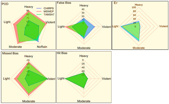
Figure 11.
Radar chart of SRP error decomposition by rain event category.
3.8. Elevation Dependent Variations in the Detection and Accuracy of SRPs
The elevation rainfall plot (Figure 12) shows a positive trend, but weak R2 values (less than 0.5) across all SRPs and sub-basins suggest elevation alone poorly explains rainfall variability. The relationship is stronger in the North sub-basin, implying elevation has more influence there. Differences in the coefficient of determination among the SRPs can be attributed to differences in spatial resolution and data density. MSWEP, with its coarser spatial resolution, results in higher R2 values. Conversely, finer resolutions that capture spatial heterogeneity such as TAMSAT and CHIRPS have lower R2 values. Thus, variations in R2 among the products correspond with their spatial resolution and the scale of relationship is assessed.
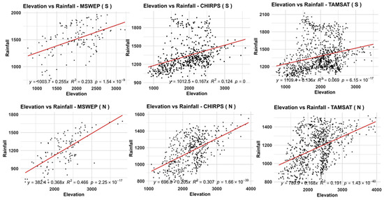
Figure 12.
Elevation dependence of satellite rainfall products: rainfall distribution across elevation increments.
Further analysis (Figure 13) reveled across all stations CHIRPS and TAMSAT exhibit significant negative correlations between elevation and several categorical metrics, especially POD, FBS, FB, and CSI, indicating that as elevation increases these products miss more events and show stronger detection bias, whereas MSWEP shows no significant relationships. In the North, significant positive correlations between elevation and error-type metrics (Er for CHIRPS and MSWEP) indicate that errors increase with elevation (significant for MSWEP only), while most skill and categorical metrics remain non-significant, implying that elevation mainly affects the magnitude of error rather than overall detection structure. In the South, CHIRPS and TAMSAT display strong, significant negative correlations between elevation and POD and FBS, revealing that their event detection skill deteriorates markedly at higher southern elevations, whereas MSWEP again shows no significant change with elevation, reinforcing its comparatively robust performance across terrain.
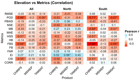
Figure 13.
Heat map showing correlations between elevation and rainfall metrics/errors across South and North Gojjam, with statistically significant values marked by *.
Previous studies support these findings. For instance, studies by [74,82] note that PERSIANN underestimates rainfall at high elevations due to weak orographic sensitivity. These findings are consistent with the decreasing rainfall trend observed at high elevations in the South (Figure 12), which may contribute to systematic biases in SRPs estimates. Similarly, [83] linked TAMSAT’s underestimation at high elevations to challenges in detecting warm-topped shallow convection, also noted by [5] at highland stations. Persistent underestimation by CHIRPS has been documented by [58], with CHIRPS was found to be the least effective in detecting daily rainfall above 1500 m a.s.l. In contrast MSWEP appeared largely unaffected by elevation [27].
3.9. Monthly and Seasonal Total Rainfall Performance
Monthly performance analysis showed (Table 6) better results than daily data. CHIRPS consistently led across most metrics, aligning with [24,48]. MSWEP and TAMSAT also performed well (R2 greater than 0.6), with only minor differences among SRPs. Bias patterns mirrored those at the daily scale. These results support earlier findings that SRPs’ accuracy improves with temporal aggregation, confirming their reliability in capturing monthly rainfall patterns.
Table 6.
Performance evaluation of satellite rainfall estimates at monthly and seasonal scales.
At the seasonal scale, MAM rainfall is reproduced reasonably well in both regions, with R2 and NSE around 0.5–0.7, moderate MAE/RMSE, and only modest over- or underestimation. In contrast, JJAS performance is much weaker: while R2 remains moderate in the North, NSE drops to 0.2–0.4 there and becomes strongly negative (−0.8 to −1.4) in the South, accompanied by substantially larger MAE and RMSE, indicating that all products struggle to capture JJAS totals, especially over South Gojjam.
Across products and regions, most monthly differences are not statistically significant in correlation, bias, or efficiency (Supplementary Tables S11–S16). Significant contrasts mainly involve TAMSAT: in both North and South, CHIRPS and MSWEP have significantly lower MAE/RMSE and higher NSE than TAMSAT for monthly and JJAS rainfall, while CHIRPS and MSWEP rarely differ significantly from each other. For MAM, products are statistically similar in MAE, RMSE, and NSE within each region; the main significant differences are that TAMSAT has lower R2 and more negative bias than the others. Cross-region tests show that, for JJAS, all products perform significantly worse in the South than in the North, with lower R2 and much lower NSE, whereas regional differences for monthly and MAM metrics are generally not significant.
4. Conclusions
Satellite-based rainfall products (SRPs) are indispensable for hydro-climatology research, providing broad spatial coverage, filling gaps in ground observations, and supporting climate modeling and water resource planning. In the North and South Gojjam sub-basins, SRPs reproduce the broad rainfall distribution patterns effectively, but their accuracy is constrained by complex terrain, elevation effects, and rainfall variability. Rainfall patterns are shaped more by local climate and topography than elevation alone, with South Gojjam experiencing heavier and more variable rainfall compared to the more uniform North. Although rainfall generally increases with elevation, weak correlations (R2 < 0.5) indicate that elevation alone is not a reliable predictor, particularly in the South. All SRPs tend to underestimate rainfall variability in the South, while performing more reliably in the North. Bias decomposition and error analysis reveal that random error dominates for some products, while systematic error is more pronounced for others. Detection skill improves with rainfall intensity, but light rainfall events remain the most difficult to capture. Seasonal evaluations show better agreement during MAM than JJAS, though regional biases persist.
MSWEP demonstrates strong consistency, with the highest correlation to ground data, lowest error metrics, and superior daily rainfall detection. Its error composition is dominated by low random error (~52%), making it the most stable across regions. Bias patterns include slight overestimation of rainfall and rainy days, plus low-intensity false alarms (false bias as a key source). Performance improves with temporal aggregation (monthly, especially MAM), though variability is smoothed in complex terrain like South Gojjam.
TAMSAT provides finer-resolution data that capture localized variability and align well with station data, particularly for dry conditions. It has the lowest false alarm rate and performs better in detecting rainfall occurrence in the South basin. Its error composition shows moderate random error (~59%), reflecting mixed stability. TAMSAT tends to underestimate rainfall during MAM, shows declining detection skill with elevation, and misclassifies rainfall intensity despite improvements at higher intensities.
CHIRPS exhibits weaker daily performance but improves at monthly scales. Its error composition is dominated by high random error (~66%), reflecting greater variability and missed events. CHIRPS overestimates zero-rain days and underestimates light rainfall yet captures heavy and violent rainfall closer to gauges. Missed bias increases with elevation, particularly in the South, and moderate rainfall is often overestimated. Seasonally, it overestimates in MAM and underestimates in JJAS, with efficiency diverging between North (positive) and South (negative).
While this study provides valuable insights into the performance of satellite rainfall products over the Upper Blue Nile Basin, several limitations should be noted. Complete independence of the validation gauges from calibration datasets cannot be fully guaranteed. The relatively small gauge network may reduce representativeness. The analysis period (2009–2018) may not capture longer-term variability. Elevation was the only terrain factor considered, while other attributes (slope, aspect, agro-ecological zones) may also influence errors. Finally, categorical rainfall events with limited samples yield wide confidence intervals, so conclusions for these categories should be interpreted cautiously.
Future research should expand the gauge network to improve spatial coverage, incorporate longer time periods to capture climate variability, and apply multivariate approaches that include slope, aspect, and land use factors. In addition, spatial autocorrelation tests and advanced error decomposition methods could provide deeper insights into product performance and uncertainty across diverse hydro-climatic settings.
Supplementary Materials
The following supporting information is available online at: https://www.mdpi.com/article/10.3390/rs18010002/s1, Tables S1–S16: Station locations (S1); cross-product/region comparisons of continuous/categorical metrics, bias decomposition (hit/missed/false), systematic/random errors (all intensities, monthly, MAM, JJAS) for CHIRPS, TAMSAT, MSWEP in North/South Gojjam; Figure S1: Significant elevation-metrics correlations.
Author Contributions
T.T.G. conceptualized the methodology, conducted data analysis, and drafted the manuscript. A.M.M. and B.A. contributed to manuscript writing, review, editing, and provided supervision. All authors have read and agreed to the published version of the manuscript.
Funding
This research did not receive finical support from external sources.
Data Availability Statement
Gauge data from the Ethiopian NMA are restricted; satellite rainfall products (CHIRPS, MSWEP, TAMSAT) are publicly available. Derived datasets are available from the corresponding author upon reasonable request.
Acknowledgments
The authors gratefully acknowledge the Africa Center of Excellence for Water Management (ACEWM) at Addis Ababa University for providing financial support for this study. Special thanks are extended to the National Meteorological Agency (NMA) for supplying the rainfall data used for validation.
Conflicts of Interest
The authors declare no conflicts of interest.
References
- Gebremicael, T.G.; Mohamed, Y.A.; Zaag, P.V.; Hagos, E.Y. Temporal and spatial changes of rainfall and streamflow in the Upper Tekezē–Atbara river basin, Ethiopia. Hydrol. Earth Syst. Sci. 2017, 21, 2127–2142. [Google Scholar] [CrossRef]
- Dos Santos, V.; Oliveira, R.J.; Datok, P.; Sauvage, S.; Paris, A.; Gosset, M.; Sánchez-Pérez, J. Evaluating the performance of multiple satellite-based precipitation products in the Congo River Basin using the SWAT model. J. Hydrol. Reg. Stud. 2022, 42, 101168. [Google Scholar] [CrossRef]
- Tola, F.T.; Dadi, D.K.; Kenea, T.T.; Dinku, T. Weather and climate services in Ethiopia: Progress, challenges, and opportunities. Front. Clim. 2025, 7, 1551188. [Google Scholar] [CrossRef]
- Hong, Y.; Tang, G.; Ma, Y.; Huang, Q.; Han, Z.; Zeng, Z.; Yang, Y.; Wang, C.; Guo, X. Remote Sensing Precipitation: Sensors, Retrievals, Validations, and Applications; Springer: Berlin/Heidelberg, Germany, 2018; pp. 1–23. [Google Scholar] [CrossRef]
- Abera, W.; Brocca, L.; Rigon, R. Comparative evaluation of different satellite rainfall estimation products and bias correction in the Upper Blue Nile (UBN) basin. Atmos. Res. 2016, 178–179, 471–483. [Google Scholar] [CrossRef]
- Gebremichael, M.; Anagnostou, E.N.; Bitew, M.M. Critical Steps for Continuing Advancement of Satellite Rainfall Applications for Surface Hydrology in the Nile River Basin. JAWRA J. Am. Water Resour. Assoc. 2010, 46, 361–366. [Google Scholar] [CrossRef]
- Dinku, T.; Ceccato, P.; Grover-Kopec, E.; Lemma, M.; Connor, S.J.; Ropelewski, C.F. Validation of satellite rainfall products over East Africa’s complex topography. Int. J. Remote. Sens. 2007, 28, 1503–1526. [Google Scholar] [CrossRef]
- Nair, A.S.; Indu, J. Performance Assessment of Multi-Source Weighted-Ensemble Precipitation (MSWEP) Product over India. Climate 2017, 5, 2. [Google Scholar] [CrossRef]
- Alijanian, M.; Rakhshandehroo, G.R.; Mishra, A.K.; Dehghani, M. Evaluation of satellite rainfall climatology using CMORPH, PERSIANN-CDR, PERSIANN, TRMM, MSWEP over Iran. Int. J. Climatol. 2017, 37, 4896–4914. [Google Scholar] [CrossRef]
- Ali, S.; Chen, Y.; Azmat, M.; Kayumba, P.M.; Ahmed, Z.; Mind’je, R.; Ghaffar, A.; Qin, J.; Tariq, A. Long-Term Performance Evaluation of the Latest Multi-Source Weighted-Ensemble Precipitation (MSWEP) over the Highlands of Indo-Pak (1981–2009). Remote. Sens. 2022, 14, 4773. [Google Scholar] [CrossRef]
- Paul, S.; Sharma, P.J.; Teegavarapu, R.S. Rain event detection and magnitude estimation during Indian summer monsoon: Comprehensive assessment of gridded precipitation datasets across hydroclimatically diverse regions. Atmos. Res. 2025, 313, 107761. [Google Scholar] [CrossRef]
- Al-Falahi, A.H.; Saddique, N.; Spank, U.; Gebrechorkos, S.H.; Bernhofer, C. Evaluation the Performance of Several Gridded Precipitation Products over the Highland Region of Yemen for Water Resources Management. Remote. Sens. 2020, 12, 2984. [Google Scholar] [CrossRef]
- Liu, C.Y.; Aryastana, P.; Liu, G.R.; Huang, W.R. Assessment of satellite precipitation product estimates over Bali Island. Atmos. Res. 2020, 244, 105032. [Google Scholar] [CrossRef]
- Zambrano-Bigiarini, M.; Nauditt, A.; Birkel, C.; Verbist, K.; Ribbe, L. Temporal and spatial evaluation of satellite-based rainfall estimates across the complex topographical and climatic gradients of Chile. Hydrol. Earth Syst. Sci. 2017, 21, 1295–1320. [Google Scholar] [CrossRef]
- An, Y.; Zhao, W.; Li, C.; Liu, Y. Evaluation of Six Satellite and Reanalysis Precipitation Products Using Gauge Observations over the Yellow River Basin, China. Atmosphere 2020, 11, 1223. [Google Scholar] [CrossRef]
- Prajapati, R.; Silwal, P.; Duwal, S.; Shrestha, S.; Kafle, A.S.; Talchabhadel, R.; Kumar, S. Detectability of rainfall characteristics over a mountain river basin in the Himalayan region from 2000 to 2015 using ground- and satellite-based products. Theor. Appl. Clim. 2021, 147, 185–204. [Google Scholar] [CrossRef]
- Dembélé, M.; Zwart, S.J. Evaluation and comparison of satellite-based rainfall products in Burkina Faso, West Africa. Int. J. Remote. Sens. 2016, 37, 3995–4014. [Google Scholar] [CrossRef]
- Garba, J.N.; Diasso, U.J.; Waongo, M.; Sawadogo, W.; Daho, T. Performance evaluation of satellite-based rainfall estimation across climatic zones in Burkina Faso. Theor. Appl. Clim. 2023, 154, 1051–1073. [Google Scholar] [CrossRef]
- Cattani, E.; Ferguglia, O.; Merino, A.; Levizzani, V. Precipitation Products’ Inter–Comparison over East and Southern Africa 1983–2017. Remote. Sens. 2021, 13, 4419. [Google Scholar] [CrossRef]
- Mekonnen, K.; Velpuri, N.M.; Leh, M.; Akpoti, K.; Owusu, A.; Tinonetsana, P.; Hamouda, T.; Ghansah, B.; Paranamana, T.P.; Munzimi, Y. Accuracy of satellite and reanalysis rainfall estimates over Africa: A multi-scale assessment of eight products for continental applications. J. Hydrol. Reg. Stud. 2023, 49, 101514. [Google Scholar] [CrossRef]
- Ageet, S.; Fink, A.H.; Maranan, M.; Diem, J.E.; Hartter, J.; Ssali, A.L.; Ayabagabo, P. Validation of Satellite Rainfall Estimates over Equatorial East Africa. J. Hydrometeorol. 2022, 23, 129–148. [Google Scholar] [CrossRef]
- Salami, A.A.; Olanrewaju, R.M.; Olorunfemi, J.F. Performance assessment of satellite rainfall estimates in rain detection capabilities at different thresholds over Nigeria. Hydrol. Sci. J. 2024, 69, 1997–2009. [Google Scholar] [CrossRef]
- Khettouch, A.; Hssaisoune, M.; Hermans, T.; Aouijil, A.; Bouchaou, L. Ground validation of satellite-based precipitation estimates over poorly gauged catchment: The case of the Drâa basin in Central-East Morocco. Mediterr. Geosci. Rev. 2023, 5, 159–175. [Google Scholar] [CrossRef]
- Taye, M.; Mengistu, D.; Sahlu, D. Performance evaluation of multiple satellite rainfall data sets in central highlands of Abbay Basin, Ethiopia. Eur. J. Remote. Sens. 2023, 56, 2233686. [Google Scholar] [CrossRef]
- Addisu, S.; Aniley, E.; Gashaw, T.; Kelemu, S.; Demessie, S.F. Evaluating the performances of gridded satellite products in simulating the rainfall characteristics of Abay Basin, Ethiopia. Sustain. Environ. 2024, 10, 2381349. [Google Scholar] [CrossRef]
- Ayehu, G.T.; Tadesse, T.; Gessesse, B.; Dinku, T. Validation of new satellite rainfall products over the Upper Blue Nile Basin, Ethiopia. Atmos. Meas. Tech. 2018, 11, 1921–1936. [Google Scholar] [CrossRef]
- Abebe, S.A.; Qin, T.; Yan, D.; Gelaw, E.B.; Workneh, H.T.; Kun, W.; Liu, S.; Dong, B. Spatial and Temporal Evaluation of the Latest High-Resolution Precipitation Products over the Upper Blue Nile River Basin, Ethiopia. Water 2020, 12, 3072. [Google Scholar] [CrossRef]
- Fenta, A.A.; Yasuda, H.; Shimizu, K.; Ibaraki, Y.; Haregeweyn, N.; Kawai, T.; Belay, A.S.; Sultan, D.; Ebabu, K. Evaluation of satellite rainfall estimates over the Lake Tana basin at the source region of the Blue Nile River. Atmos. Res. 2018, 212, 43–53. [Google Scholar] [CrossRef]
- Alemu, M.M.; Bawoke, G.T. Analysis of spatial variability and temporal trends of rainfall in Amhara region, Ethiopia. J. Water Clim. Chang. 2019, 11, 1505–1520. [Google Scholar] [CrossRef]
- Ayehu, G.T.; Tadesse, T.; Gessesse, B. Spatial and temporal trends and variability of rainfall using long-term satellite product over the Upper Blue Nile Basin in Ethiopia. Remote Sens. Earth Syst. Sci. 2021, 4, 199–215. [Google Scholar] [CrossRef]
- Bayable, G.; Amare, G.; Alemu, G.; Gashaw, T. Spatiotemporal variability and trends of rainfall and its association with Pacific Ocean Sea surface temperature in West Harerge Zone, Eastern Ethiopia. Environ. Syst. Res. 2021, 10, 7. [Google Scholar] [CrossRef]
- Mohammed, J.A.; Yimam, Z.A. Spatiotemporal variability and trend analysis of rainfall in Beshilo sub-basin, Upper Blue Nile (Abbay) Basin of Ethiopia. Arab. J. Geosci. 2022, 15, 1387. [Google Scholar] [CrossRef]
- Bewket, W.; Tibebe, D.; Teferi, E.; Degefu, M.A. Changes in mean and extreme rainfall indices over a problemscape in central Ethiopia. Environ. Chall. 2024, 15, 100883. [Google Scholar] [CrossRef]
- Thiemig, V.; Rojas, R.; Zambrano-Bigiarini, M.; De Roo, A. Hydrological evaluation of satellite-based rainfall estimates over the Volta and Baro-Akobo Basin. J. Hydrol. 2013, 499, 324–338. [Google Scholar] [CrossRef]
- Knoche, M.; Fischer, C.; Pohl, E.; Krause, P.; Merz, R. Combined uncertainty of hydrological model complexity and satellite-based forcing data evaluated in two data-scarce semi-arid catchments in Ethiopia. J. Hydrol. 2014, 519, 2049–2066. [Google Scholar] [CrossRef]
- Jung, H.C.; Getirana, A.; Policelli, F.; McNally, A.; Arsenault, K.R.; Kumar, S.; Tadesse, T.; Peters-Lidard, C.D. Upper Blue Nile basin water budget from a multi-model perspective. J. Hydrol. 2017, 555, 535–546. [Google Scholar] [CrossRef]
- Alato, A.A. Satellite Based Rainfall and Potential Evaporation for Streamflow Simulation and Water Balance Assessment: A case Study in Wabi Watershed, Ethiopia. Master’s Thesis, University of Twente, Enschede, The Netherlands, 2019. [Google Scholar]
- Duan, Z.; Tuo, Y.; Liu, J.; Gao, H.; Song, X.; Zhang, Z.; Yang, L.; Mekonnen, D.F. Hydrological evaluation of open-access precipitation and air temperature datasets using SWAT in a poorly gauged basin in Ethiopia. J. Hydrol. 2019, 569, 612–626. [Google Scholar] [CrossRef]
- Goshime, D.W.; Absi, R.; Haile, A.T.; Ledésert, B.; Rientjes, T. Bias-Corrected CHIRP Satellite Rainfall for Water Level Simulation, Lake Ziway, Ethiopia. J. Hydrol. Eng. 2020, 25, 05020024. [Google Scholar] [CrossRef]
- Ibrahim, A.H.; Molla, D.D.; Lohani, T.K. Performance evaluation of satellite-based rainfall estimates for hydrological modeling over Bilate river basin, Ethiopia. World J. Eng. 2022, 21, 1–15. [Google Scholar] [CrossRef]
- Bayissa, Y.; Tadesse, T.; Demisse, G.; Shiferaw, A. Evaluation of Satellite-Based Rainfall Estimates and Application to Monitor Meteorological Drought for the Upper Blue Nile Basin, Ethiopia. Remote Sens. 2017, 9, 669. [Google Scholar] [CrossRef]
- Bayissa, Y.A.; Tadesse, T.; Svoboda, M.; Wardlow, B.; Poulsen, C.; Swigart, J.; Van Andel, S.J. Developing a satellite-based combined drought indicator to monitor agricultural drought: A case study for Ethiopia. GIScience Remote Sens. 2019, 56, 718–748. [Google Scholar] [CrossRef]
- Tesfamariam, B.G.; Melgani, F.; Gessesse, B. Rainfall retrieval and drought monitoring skill of satellite rainfall estimates in the Ethiopian Rift Valley Lakes Basin. J. Appl. Remote. Sens. 2019, 13, 014522. [Google Scholar] [CrossRef]
- Taye, M.; Sahlu, D.; Zaitchik, B.F.; Neka, M. Evaluation of Satellite Rainfall Estimates for Meteorological Drought Analysis over the Upper Blue Nile Basin, Ethiopia. Geosciences 2020, 10, 352. [Google Scholar] [CrossRef]
- Dejene, T.; Dalle, G.; Woldeamanuel, T.; Mekuyie, M. Temporal climate conditions and spatial drought patterns across rangelands in pastoral areas of West Guji and Borana zones, Southern Ethiopia. Pastoralism 2023, 13, 18. [Google Scholar] [CrossRef]
- Shalishe, A.; Berihu, T.; Arba, Y. Performance evaluation of multi-satellite rainfall products for analyzing rainfall variability in Abaya–Chamo basin: Southern Ethiopia. J. Earth Syst. Sci. 2024, 133, 139. [Google Scholar] [CrossRef]
- Dinku, T.; Funk, C.; Peterson, P.; Maidment, R.; Tadesse, T.; Gadain, H.; Ceccato, P. Validation of the CHIRPS satellite rainfall estimates over eastern Africa. Q. J. R. Meteorol. Soc. 2018, 144, 292–312. [Google Scholar] [CrossRef]
- Malede, D.A.; Agumassie, T.A.; Kosgei, J.R.; Pham, Q.B.; Andualem, T.G. Evaluation of Satellite Rainfall Estimates in a Rugged Topographical Basin Over South Gojjam Basin, Ethiopia. J. Indian Soc. Remote Sens. 2022, 50, 1333–1346. [Google Scholar] [CrossRef]
- Asefw, E.T.; Ayehu, G.T. Validating the Skills of Satellite Rainfall Products and Spatiotemporal Rainfall Variability Analysis over Omo River Basin in Ethiopia. Hydrology 2024, 12, 36–51. [Google Scholar] [CrossRef]
- Wodebo, D.Y.; Melesse, A.M.; Woldesenbet, T.A.; Mekonnen, K.; Amdihun, A.; Korecha, D.; Tedla, H.Z.; Corzo, G.; Teshome, A. Comprehensive performance evaluation of satellite-based and reanalysis rainfall estimate products in Ethiopia: For drought, flood, and water resources applications. J. Hydrol. Reg. Stud. 2025, 57, 102150. [Google Scholar] [CrossRef]
- Romilly, T.G.; Gebremichael, M. Evaluation of satellite rainfall estimates over Ethiopian river basins. Hydrol. Earth Syst. Sci. 2011, 15, 1505–1514. [Google Scholar] [CrossRef]
- Yilma, A.D.; Awulachew, S.B. Characterization and Atlas of the Blue Nile Basin and Its Sub Basins; International Water Management Institute (IWMI): Colombo, Sri Lanka, 2009. [Google Scholar]
- Tadesse, M.; Alemu, B.; Bekele, G.; Tebikew, T.; Chamberlin, J.; Benson, T. Atlas of the Ethiopian Rural Economy; International Food Policy Research Institute (IFPRI): Washington, DC, USA; Central Statistical Agency, Ethiopian Development Research Institute: Addis Ababa, Ethiopia, 2006. [Google Scholar]
- Maidment, R.I.; Grimes, D.; Black, E.; Tarnavsky, E.; Young, M.; Greatrex, H.; Allan, R.P.; Stein, T.; Nkonde, E.; Senkunda, S.; et al. A new, long-term daily satellite-based rainfall dataset for operational monitoring in Africa. Sci. Data 2017, 4, 170063. [Google Scholar] [CrossRef]
- Funk, C.; Peterson, P.; Landsfeld, M.; Pedreros, D.; Verdin, J.; Shukla, S.; Husak, G.; Rowland, J.; Harrison, L.; Hoell, A.; et al. The climate hazards infrared precipitation with stations—A new environmental record for monitoring extremes. Sci. Data 2015, 2, 150066. [Google Scholar] [CrossRef]
- Beck, H.E.; Wood, E.F.; Pan, M.; Fisher, C.K.; Miralles, D.G.; van Dijk, A.I.J.M.; McVicar, T.R.; Adler, R.F. MSWEP V2 Global 3-Hourly 0.1° Precipitation: Methodology and Quantitative Assessment. Bull. Am. Meteorol. Soc. 2019, 100, 473–500. [Google Scholar] [CrossRef]
- Dinku, T.; Alessandrini, S.; Evangelisti, M.; Rojas, O. A description and evaluation of FAO satellite rainfall estimation algorithm. Atmos. Res. 2015, 163, 48–60. [Google Scholar] [CrossRef]
- Gebremicael, T.G.; Mohamed, Y.A.; van der Zaag, P.; Gebremedhin, A.; Gebremeskel, G.; Yazew, E.; Kifle, M. Evaluation of multiple satellite rainfall products over the rugged topography of the Tekeze-Atbara basin in Ethiopia. Int. J. Remote Sens. 2019, 40, 4326–4345. [Google Scholar] [CrossRef]
- Aniley, E.; Gashaw, T.; Abraham, T.; Demessie, S.F.; Bayabil, H.K.; Worqlul, A.W.; van Oel, P.R.; Dile, Y.T.; Chukalla, A.D.; Haileslassie, A.; et al. Evaluating the performances of gridded satellite/reanalysis products in representing the rainfall climatology of Ethiopia. Geocarto Int. 2023, 38, 2278329. [Google Scholar] [CrossRef]
- Dinku, T.; Chidzambwa, S.; Ceccato, P.; Connor, S.J.; Ropelewski, C.F. Validation of high-resolution satellite rainfall products over complex terrain. Int. J. Remote Sens. 2008, 29, 4097–4110. [Google Scholar] [CrossRef]
- Belay, A.S.; Fenta, A.A.; Yenehun, A.; Nigate, F.; Tilahun, S.A.; Moges, M.M.; Dessie, M.; Adgo, E.; Nyssen, J.; Chen, M.; et al. Evaluation and Application of Multi-Source Satellite Rainfall Product CHIRPS to Assess Spatio-Temporal Rainfall Variability on Data-Sparse Western Margins of Ethiopian Highlands. Remote Sens. 2019, 11, 2688. [Google Scholar] [CrossRef]
- Tadesse, K.E.; Melesse, A.M.; Abebe, A.; Lakew, H.B.; Paron, P. Evaluation of Global Precipitation Products over Wabi Shebelle River Basin, Ethiopia. Hydrology 2022, 9, 66. [Google Scholar] [CrossRef]
- Moriasi, D.N.; Arnold, J.G.; Van Liew, M.W.; Bingner, R.L.; Harmel, R.D.; Veith, T.L. Model Evaluation Guidelines for Systematic Quantification of Accuracy in Watershed Simulations. Trans. ASABE 2007, 50, 885–900. [Google Scholar] [CrossRef]
- Nash, J.E.; Sutcliffe, J.V. River Flow Forecasting through Conceptual Model. Part 1—A Discussion of Principles. J. Hydrol. 1970, 10, 282–290. [Google Scholar] [CrossRef]
- Mekonnen, K.; Melesse, A.M.; Woldesenbet, T.A. Spatial evaluation of satellite-retrieved extreme rainfall rates in the Upper Awash River Basin, Ethiopia. Atmos. Res. 2021, 249, 105192. [Google Scholar] [CrossRef]
- Gebremichael, M.; Bitew, M.M.; Hirpa, F.A.; Tesfay, G.N. Accuracy of satellite rainfall estimates in the Blue Nile Basin: Lowland plain versus highland mountain. Water Resour. Res. 2014, 50, 8775–8790. [Google Scholar] [CrossRef]
- Alemseged, T.H.; Tom, R. Evaluation of regional climate model simulations of rainfall over the Upper Blue Nile basin. Atmos. Res. 2015, 161–162, 57–64. [Google Scholar] [CrossRef]
- Tian, Y.; Peters-Lidard, C.D.; Eylander, J.B.; Joyce, R.J.; Huffman, G.J.; Adler, R.F.; Hsu, K.; Turk, F.J.; Garcia, M.; Zeng, J. Component analysis of errors in satellite-based precipitation estimates. J. Geophys. Res. Atmos. 2009, 114, D24101. [Google Scholar] [CrossRef]
- Chaudhary, S.; Dhanya, C. An improved error decomposition scheme for satellite-based precipitation products. J. Hydrol. 2021, 598, 126434. [Google Scholar] [CrossRef]
- Li, R.; Guilloteau, C.; Kirstetter, P.; Foufoula-Georgiou, E. A New Event-Based Error Decomposition Scheme for Satellite Precipitation Products. Geophys. Res. Lett. 2023, 50, e2023GL105343. [Google Scholar] [CrossRef]
- Chen, H.; Yong, B.; Kirstetter, P.E.; Wang, L.; Hong, Y. Global component analysis of errors in three satellite-only global precipitation estimates. Hydrol. Earth Syst. Sci. 2021, 25, 3087–3104. [Google Scholar] [CrossRef]
- Willmott, C.J. On the Validation of Models. Phys. Geogr. 1981, 2, 184–194. [Google Scholar] [CrossRef]
- AghaKouchak, A.; Mehran, A.; Norouzi, H.; Behrangi, A. Systematic and random error components in satellite precipitation data sets. Geophys. Res. Lett. 2012, 39, L09406. [Google Scholar] [CrossRef]
- Hirpa, F.A.; Gebremichael, M.; Hopson, T. Evaluation of High-Resolution Satellite Precipitation Products over Very Complex Terrain in Ethiopia. J. Appl. Meteorol. Climatol. 2010, 49, 1044–1051. [Google Scholar] [CrossRef]
- Welch, B.L. The generalization of ‘student’s’ Problem when several different population varlances are involved. Biometrika 1947, 34, 28–35. [Google Scholar] [CrossRef]
- Wilcoxon, F. Individual Comparisons by Ranking Methods. Biom. Bull. 1945, 1, 80–270. [Google Scholar] [CrossRef]
- Mann, H.B.; Whitney, D.R. On a Test of Whether one of Two Random Variables is Stochastically Larger than the Other. Ann. Math. Stat. 1947, 18, 50–60. [Google Scholar] [CrossRef]
- Mersha, G.T.; Mekuriaw, A. Evaluation of daily based satellite rainfall estimates for flood monitoring in Gumera Watershed, Amhara region, Ethiopia. Cogent Soc. Sci. 2025, 11, 2433690. [Google Scholar] [CrossRef]
- Gebremedhin, M.A.; Lubczynski, M.W.; Maathuis, B.H.; Teka, D. Novel approach to integrate daily satellite rainfall with in-situ rainfall, Upper Tekeze Basin, Ethiopia. Atmos. Res. 2021, 248, 105192. [Google Scholar] [CrossRef]
- Haile, A.T.; Yan, F.; Habib, E. Accuracy of the CMORPH satellite-rainfall product over Lake Tana Basin in Eastern Africa. Atmos. Res. 2015, 163, 177–187. [Google Scholar] [CrossRef]
- Wang, J.; Chen, H.; Xu, C.Y.; Zeng, Q.; Wang, Q.; Kim, J.S.; Chen, J.; Guo, S. Tracking the error sources of spatiotemporal differences in TRMM accuracy using error decomposition method. Hydrol. Res. 2018, 49, 1960–1976. [Google Scholar] [CrossRef]
- Adane, G.B.; Hirpa, B.A.; Lim, C.H.; Lee, W.K. Evaluation and Comparison of Satellite-Derived Estimates of Rainfall in the Diverse Climate and Terrain of Central and Northeastern Ethiopia. Remote Sens. 2021, 13, 1275. [Google Scholar] [CrossRef]
- Young, M.P.; Williams, C.J.R.; Chiu, J.C.; Maidment, R.I.; Chen, S.H. Investigation of Discrepancies in Satellite Rainfall Estimates over Ethiopia. J. Hydrometeorol. 2014, 15, 2347–2369. [Google Scholar] [CrossRef]


Disclaimer/Publisher’s Note: The statements, opinions and data contained in all publications are solely those of the individual author(s) and contributor(s) and not of MDPI and/or the editor(s). MDPI and/or the editor(s) disclaim responsibility for any injury to people or property resulting from any ideas, methods, instructions or products referred to in the content. |
© 2025 by the authors. Licensee MDPI, Basel, Switzerland. This article is an open access article distributed under the terms and conditions of the Creative Commons Attribution (CC BY) license.