
DS Net: A Dual-Coded Segmentation Network Leveraging Large Model Prior Knowledge for Intelligent Landslide Extraction


 ,
,
Abstract
1. Introduction
- (1)
- A library of landslide identification samples was created using high-resolution remote sensing imagery and landslide boundary data obtained through field validation.
- (2)
- The large model has billions or even hundreds of billions of parameters. It is trained by inputting large amounts of data, enabling the computer to acquire human-like “thinking” abilities and perform a variety of complex tasks, including image generation. In this paper, we design DSNet, which realizes the dynamic alignment and deep fusion of local details with global context, image features with domain knowledge, and significantly improves the accuracy and reliability of landslide detection through the multi-attention mechanism of Prior Knowledge Integration (PKI) module and Cross-Feature Aggregation (CFA) module.
- (3)
- Test the model’s prediction results on the landslide sample set under different data augmentation modes to determine the optimal data augmentation strategy for landslide identification within the study area.
2. Materials and Methods
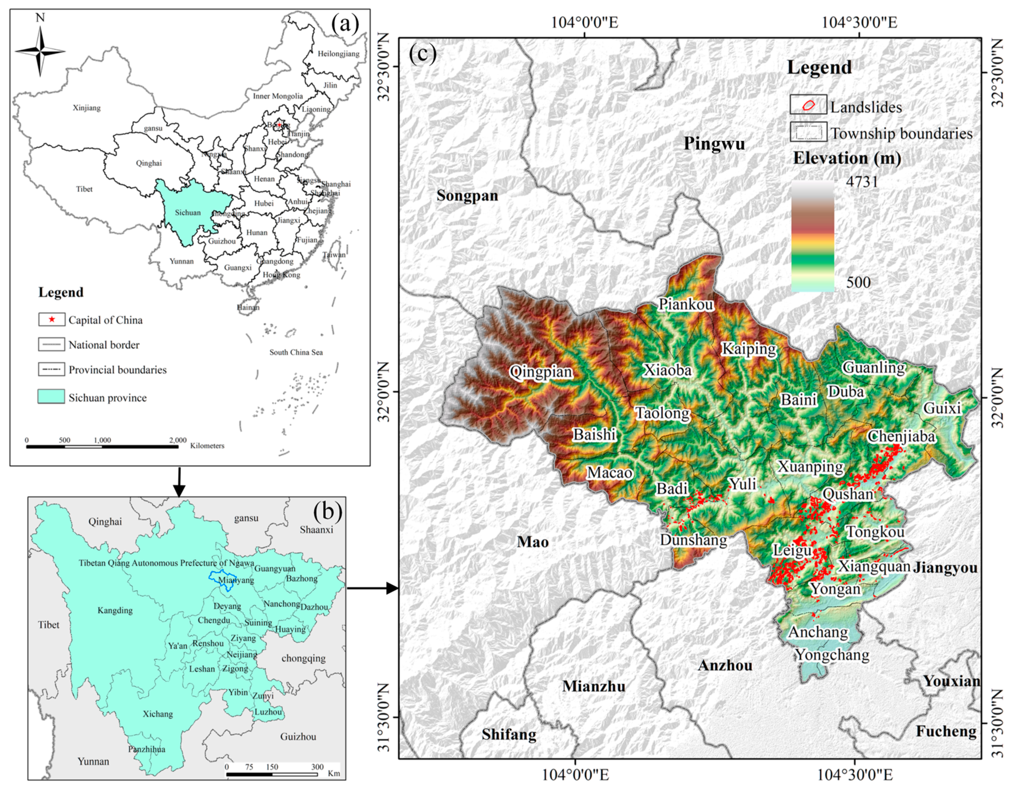
2.1. Study Area
2.2. Production of a Landslide Identification Database
- (1)
- Based on the existing landslide interpretation signs, the vector editing tool in ArcGIS 10.8 was used to edit the remote sensing images in TIFF format (Figure 2), and the boundaries were manually outlined through visual interpretation. Since the accuracy of boundary outlining directly affects the quality of the landslide sample library, to improve the precision of landslide samples and the accuracy of model training, it is necessary to strictly control vector outlining errors during the process. The error range of the outlined vector boundaries should be kept within 1–2 pixels.
- (2)
- ArcGIS software was used to assign attributes to the landslide interpretation data by adding a “label” attribute field to the outlined landslide boundary data. The landslide attribute field was assigned a value of “1”, while the non-landslide background was assigned a value of “0”.
- (3)
- Python 3.6, combined with the GDAL library, was used to convert vector files into raster files based on the assigned attribute field values. The relevant information was read from the raster files to create binary maps, ultimately generating the label data required for constructing the vegetation sample library. Additionally, it was ensured that the generated raster data matched the number of rows and columns in the image data.
- (4)
- Due to limited computer memory, the entire remote sensing image contains too much information to be used directly as input for the network model. Therefore, the remote sensing image and its corresponding landslide labeling data must be divided into several smaller images to ensure compatibility with the model for training. To simplify the processing of remote sensing images and enable the network model to better extract detailed landslide features while ensuring effective convergence, the dataset was divided into images of 256 × 256 pixels.
- (5)
- After processing through the sample segmentation operation, a total of 4879 high-resolution images were obtained, forming the remote sensing landslide sample library. To ensure sample diversity and make the dataset as varied as possible, the data were randomly divided into training, validation, and test sets in a ratio of 6:2:2. The training set, consisting of 2927 images, was used for model training to extract features. The validation set, comprising 976 images, was used to evaluate the model during training, while the test set, also consisting of 976 images, was used to assess the model’s performance.
2.3. Methods
2.3.1. Dual-Coded Segmentation Network (DSNet) Architecture
2.3.2. Swin Transformer
2.3.3. Evaluation Indicators
2.3.4. Implementation Details
3. Results and Analysis
3.1. Analysis of Ablation Experiment Results
3.2. Visual Analysis of Experimental Results
3.3. Comparison with Other Semantic Segmentation Models
4. Discussion
4.1. Comparison and Analysis of Different Data Enhancement Patterns
4.2. The Model Adaptation Capability of DSNet on the Bijie Dataset
4.3. Application of DS Net in Other Scenarios
4.4. Limitations and Future Work
5. Conclusions
- The DS Network with the Swin Transformer as the encoder demonstrates better accuracy compared to ResNet50 and ResNet101 in ablation experiments;
- The DS Net model excels in landslide identification tasks, significantly outperforming comparison models such as SegFormer, SegNeXt, FeedFormer, and U-MixFormer across all evaluation metrics, with specific improvements ranging from 3.5% to 7.3%;
- In the landslide identification task, excessive data enhancement can disrupt key image features and introduce noise, leading to performance degradation of the DSNet model. Therefore, the relationship between enhancement intensity and model performance must be carefully balanced.
- While DSNet achieves superior performance (Recall = 0.879, F1 = 0.882), its current limitation lies in accurately segmenting small, elongated landslides due to dataset gaps and weak edge features. Future work will combine UAV/LiDAR-based 3D morphology augmentation and GAN-generated synthetic samples with algorithm-level enhancements integrating aspect-ratio-guided attention and active contour post-processing.
Author Contributions
Funding
Data Availability Statement
Conflicts of Interest
References
- Liu, X.L.; Miao, C. Large-Scale Assessment of Landslide Hazard, Vulnerability and Risk in China. Geomat. Nat. Hazards Risk 2018, 9, 1037–1052. [Google Scholar] [CrossRef]
- Zhang, L.; Guo, Z.X.; Qi, S.; Zhao, T.H.; Wu, B.C.; Li, P. Landslide Susceptibility Evaluation and Determination of Critical Influencing Factors in Eastern Sichuan Mountainous Area, China. Ecol. Indic. 2024, 169, 112911. [Google Scholar] [CrossRef]
- Samia, J.; Temme, A.; Bregt, A.K.; Wallinga, J.; Stuiver, J.; Guzzetti, F.; Ardizzone, F.; Rossi, M. Implementing Landslide Path Dependency in Landslide Susceptibility Modelling. Landslides 2018, 15, 2129–2144. [Google Scholar] [CrossRef]
- Yang, Y.; Song, S.L.; Yue, F.C.; He, W.; Shao, W.; Zhao, K.; Nie, W. Superpixel-Based Automatic Image Recognition for Landslide Deformation Areas. Eng. Geol. 2019, 259, 105166. [Google Scholar] [CrossRef]
- Xun, Z.Y.; Zhao, C.Y.; Kang, Y.; Liu, X.J.; Liu, Y.Y.; Du, C.Y. Automatic Extraction of Potential Landslides by Integrating an Optical Remote Sensing Image with an InSAR-Derived Deformation Map. Remote Sens. 2022, 14, 2669. [Google Scholar] [CrossRef]
- Huang, F.M.; Liu, K.J.; Li, Z.Y.; Zhou, X.T.; Zeng, Z.Q.; Li, W.B.; Huang, J.S.; Catani, F.; Chang, Z.L. Single Landslide Risk Assessment Considering Rainfall-Induced Landslide Hazard and the Vulnerability of Disaster-Bearing Body. Geol. J. 2024, 59, 2549–2565. [Google Scholar] [CrossRef]
- Guo, L.J.; Miao, F.S.; Zhao, F.C.; Wu, Y.P. Data Mining Technology for the Identification and Threshold of Governing Factors of Landslide in the Three Gorges Reservoir Area. Stoch. Environ. Res. Risk Assess. 2022, 36, 3997–4012. [Google Scholar] [CrossRef]
- Goetz, J.N.; Brenning, A.; Petschko, H.; Leopold, P. Evaluating Machine Learning and Statistical Prediction Techniques for Landslide Susceptibility Modeling. Comput. Geosci. 2015, 81, 1–11. [Google Scholar] [CrossRef]
- Chen, T.H.K.; Prishchepov, A.; Fensholt, R.; Sabel, C.E. Detecting and Monitoring Long-Term Landslides in Urbanized Areas with Nighttime Light Data and Multi-Seasonal Landsat Imagery across Taiwan from 1998 to 2017. Remote Sens. Environ. 2019, 225, 317–327. [Google Scholar] [CrossRef]
- Lissak, C.; Bartsch, A.; De Michele, M.; Gomez, C.; Maquaire, O.; Raucoules, D.; Roulland, T. Remote Sensing for Assessing Landslides and Associated Hazards. Surv. Geophys. 2020, 41, 1391–1435. [Google Scholar] [CrossRef]
- Ren, P.Z.; Xiao, Y.; Chang, X.J.; Huang, P.Y.; Li, Z.H.; Gupta, B.B.; Chen, X.J.; Wang, X. A Survey of Deep Active Learning. ACM Comput. Surv. 2022, 54, 1–40. [Google Scholar] [CrossRef]
- Caroppo, A.; Leone, A.; Siciliano, P. Comparison Between Deep Learning Models and Traditional Machine Learning Approaches for Facial Expression Recognition in Ageing Adults. J. Comput. Sci. Technol. 2020, 35, 1127–1146. [Google Scholar] [CrossRef]
- Chen, L.Y.; Li, S.B.; Bai, Q.; Yang, J.; Jiang, S.L.; Miao, Y.M. Review of Image Classification Algorithms Based on Convolutional Neural Networks. Remote Sens. 2021, 13, 4712. [Google Scholar] [CrossRef]
- Zhang, R.; Lv, J.C.; Yang, Y.J.; Wang, T.Y.; Liu, G.X. Analysis of the Impact of Terrain Factors and Data Fusion Methods on Uncertainty in Intelligent Landslide Detection. Landslides 2024, 21, 1849–1864. [Google Scholar] [CrossRef]
- Dong, A.A.; Dou, J.; Li, C.D.; Chen, Z.Q.; Ji, J.; Xing, K.; Zhang, J.; Daud, H. Accelerating Cross-Scene Co-Seismic Landslide Detection Through Progressive Transfer Learning and Lightweight Deep Learning Strategies. IEEE Trans. Geosci. Remote Sens. 2024, 62. [Google Scholar] [CrossRef]
- Song, Y.; Song, Y.X.; Wang, C.N.; Wu, L.W.; Wu, W.C.; Li, Y.; Li, S.C.; Chen, A.Q. Landslide Susceptibility Assessment through Multi-Model Stacking and Meta-Learning in Poyang County, China. Geomat. Nat. Hazards Risk 2024, 15, 2354499. [Google Scholar] [CrossRef]
- Lv, P.Y.; Ma, L.S.; Li, Q.M.; Du, F. ShapeFormer: A Shape-Enhanced Vision Transformer Model for Optical Remote Sensing Image Landslide Detection. IEEE J. Sel. Top. Appl. Earth Obs. Remote Sens. 2023, 16, 2681–2689. [Google Scholar] [CrossRef]
- Chen, X.R.; Zhao, C.Y.; Lu, Z.; Xi, J.B. Landslide Inventory Mapping Based on Independent Component Analysis and UNet plus: A Case of Jiuzhaigou, China. IEEE J. Sel. Top. Appl. Earth Obs. Remote Sens. 2024, 17, 2213–2223. [Google Scholar] [CrossRef]
- Dias, P.; Potnis, A.; Guggilam, S.; Yang, L.; Tsaris, A.; Medeiros, H.; Lunga, D. An Agenda for Multimodal Foundation Models for Earth Observation. In Proceedings of the IGARSS 2023-2023 IEEE International Geoscience and Remote Sensing Symposium, Pasadena, CA, USA, 16–21 July 2023; pp. 1237–1240. [Google Scholar]
- Jiao, L.; Huang, Z.; Lu, X.; Liu, X.; Yang, Y.; Zhao, J.; Zhang, J.; Hou, B.; Yang, S.; Liu, F. Brain-Inspired Remote Sensing Foundation Models and Open Problems: A Comprehensive Survey. IEEE J. Sel. Top. Appl. Earth Obs. Remote Sens. 2023, 16, 10084–10120. [Google Scholar] [CrossRef]
- Kirillov, A.; Mintun, E.; Ravi, N.; Mao, H.; Rolland, C.; Gustafson, L.; Xiao, T.; Whitehead, S.; Berg, A.C.; Lo, W.-Y. Segment Anything. In Proceedings of the IEEE/CVF international Conference on Computer Vision, Paris, France, 2–6 October 2023; pp. 4015–4026. [Google Scholar]
- Cheng, B.; Choudhuri, A.; Misra, I.; Kirillov, A.; Girdhar, R.; Schwing, A.G. Mask2former for Video Instance Segmentation. arXiv 2021, arXiv:2112.10764. [Google Scholar]
- Ma, J.; He, Y.; Li, F.; Han, L.; You, C.; Wang, B. Segment Anything in Medical Images. Nat. Commun. 2024, 15, 654. [Google Scholar] [CrossRef] [PubMed]
- Lessee, M.A.N.; Hamburger, M.W.; Ferrara, M.R.; McLean, A.; FitzGerald, C. A Global Dataset and Model of Earthquake-Induced Landslide Fatalities. Landslides 2020, 17, 1363–1376. [Google Scholar] [CrossRef]
- Xu, Y.; Ouyang, C.; Xu, Q.; Wang, D.; Zhao, B.; Luo, Y. CAS Landslide Dataset: A Large-Scale and Multisensor Dataset for Deep Learning-Based Landslide Detection. Sci. Data 2024, 11, 12. [Google Scholar] [CrossRef] [PubMed]
- Ding, M.T.; Hu, K.H. Susceptibility Mapping of Landslides in Beichuan County Using Cluster and MLC Methods. Nat. Hazards 2014, 70, 755–766. [Google Scholar] [CrossRef]
- Qin, X.H.; Chen, Q.C.; Wu, M.L.; Tan, C.X.; Feng, C.J.; Meng, W. In-Situ Stress Measurements along the Beichuan-Yingxiu Fault after the Wenchuan Earthquake. Eng. Geol. 2015, 194, 114–122. [Google Scholar] [CrossRef]
- Radford, A.; Kim, J.W.; Hallacy, C.; Ramesh, A.; Goh, G.; Agarwal, S.; Sastry, G.; Askell, A.; Mishkin, P.; Clark, J. Learning Transferable Visual Models from Natural Language Supervision. In Proceedings of the International Conference on Machine Learning, PMLR, Online, 18–24 July 2021; pp. 8748–8763. [Google Scholar]
- Vaswani, A.; Shazeer, N.; Parmar, N.; Uszkoreit, J.; Jones, L.; Gomez, A.N.; Kaiser, Ł.; Polosukhin, I. Attention Is All You Need. In Proceedings of the Advances in Neural Information Processing Systems, Long Beach, CA, USA, 4–9 December 2017; pp. 5998–6008. [Google Scholar]
- Yang, L.; Zhang, R.-Y.; Li, L.; Xie, X. Simam: A Simple, Parameter-Free Attention Module for Convolutional Neural Networks. In Proceedings of the International conference on machine learning, PMLR, Online, 18–24 July 2021; pp. 11863–11874. [Google Scholar]
- Krizhevsky, A.; Sutskever, I.; Hinton, G.E. ImageNet Classification with Deep Convolutional Neural Networks. In Proceedings of the Advances in Neural Information Processing Systems; Pereira, F., Burges, C.J., Bottou, L., Weinberger, K.Q., Eds.; Curran Associates, Inc.: Red Hook, NY, USA, 2012; Volume 25. [Google Scholar]
- Han, K.; Wang, Y.H.; Chen, H.T.; Chen, X.H.; Guo, J.Y.; Liu, Z.H.; Tang, Y.H.; Xiao, A.; Xu, C.J.; Xu, Y.X.; et al. A Survey on Vision Transformer. IEEE Trans. Pattern Anal. Mach. Intell. 2023, 45, 87–110. [Google Scholar] [CrossRef]
- Parvaiz, A.; Khalid, M.A.; Zafar, R.; Ameer, H.; Ali, M.; Fraz, M.M. Vision Transformers in Medical Computer Vision-A Contemplative Retrospection. Eng. Appl. Artif. Intell. 2023, 122, 106126. [Google Scholar] [CrossRef]
- Xu, H.M.; Xu, Q.; Cong, F.Y.; Kang, J.; Han, C.; Liu, Z.Y.; Madabhushi, A.; Lu, C. Vision Transformers for Computational Histopathology. IEEE Rev. Biomed. Eng. 2024, 17, 63–79. [Google Scholar] [CrossRef]
- Liu, Z.; Lin, Y.; Cao, Y.; Hu, H.; Wei, Y.; Zhang, Z.; Lin, S.; Guo, B. Swin Transformer: Hierarchical Vision Transformer Using Shifted Windows. In Proceedings of the IEEE/CVF International Conference on Computer Vision, Montreal, BC, Canada, 11–17 October 2021; pp. 10012–10022. [Google Scholar]
- Hong, H.Y.; Pradhan, B.; Sameen, M.I.; Kalantar, B.; Zhu, A.X.; Chen, W. Improving the Accuracy of Landslide Susceptibility Model Using a Novel Region-Partitioning Approach. Landslides 2018, 15, 753–772. [Google Scholar] [CrossRef]
- Lv, J.C.; Zhang, R.; Wu, R.Z.; Bao, X.; Liu, G.X. Landslide Detection Based on Pixel-Level Contrastive Learning for Semi-Supervised Semantic Segmentation in Wide Areas. Landslides 2024, 22, 1087–1105. [Google Scholar] [CrossRef]
- Nohani, E.; Khazaei, S.; Dorjahangir, M.; Asadi, H.; Elkaee, S.; Mahdavi, A.; Hatamiafkoueieh, J.; Tiefenbacher, J.P. Delineating Flood-Prone Areas Using Advanced Integration of Reduced-Error Pruning Tree with Different Ensemble Classifier Algorithms. ACTA Geophys. 2024, 72, 3473–3484. [Google Scholar] [CrossRef]
- Asadi, M.; Mokhtari, L.G.; Shirzadi, A.; Shahabi, H.; Bahrami, S. A Comparison Study on the Quantitative Statistical Methods for Spatial Prediction of Shallow Landslides (Case Study: Yozidar-Degaga Route in Kurdistan Province, Iran). Environ. EARTH Sci. 2022, 81, 51. [Google Scholar] [CrossRef]
- He, K.; Zhang, X.; Ren, S.; Sun, J. Deep Residual Learning for Image Recognition. In Proceedings of the IEEE Conference on Computer Vision and Pattern Recognition, Las Vegas, NV, USA, 27–30 June 2016; pp. 770–778. [Google Scholar]
- Xie, E.; Wang, W.; Yu, Z.; Anandkumar, A.; Alvarez, J.M.; Luo, P. SegFormer: Simple and Efficient Design for Semantic Segmentation with Transformers. Adv. Neural Inf. Process. Syst. 2021, 34, 12077–12090. [Google Scholar]
- Guo, M.H.; Lu, C.Z.; Hou, Q.; Liu, Z.; Cheng, M.M.; Hu, S.M. Segnext: Rethinking Convolutional Attention Design for Semantic Segmentation. arXiv 2022, arXiv:2209.08575. [Google Scholar]
- Shim, J.; Yu, H.; Kong, K.; Kang, S.-J. Feedformer: Revisiting Transformer Decoder for Efficient Semantic Segmentation. In Proceedings of the AAAI Conference on Artificial Intelligence, Washington, DC, USA, 7–14 February 2023; Volume 37, pp. 2263–2271. [Google Scholar]
- Yeom, S.-K.; von Klitzing, J. U-MixFormer: UNet-like Transformer with Mix-Attention for Efficient Semantic Segmentation. arXiv 2023, arXiv:2312.06272. [Google Scholar]
- Wei, R.L.; Ye, C.M.; Sui, T.B.; Zhang, H.J.; Ge, Y.G.; Li, Y. A Feature Enhancement Framework for Landslide Detection. Int. J. Appl. EARTH Obs. Geoinf. 2023, 124, 103521. [Google Scholar] [CrossRef]
- Liu, Y.F.; Yang, H.L.; Jiao, R.C.; Wang, Z.P.; Wang, L.Y.; Zeng, W.; Han, J.F. A New Deformation Enhancement Method Based on Multitemporal InSAR for Landslide Surface Stability Assessment. IEEE J. Sel. Top. Appl. EARTH Obs. Remote Sens. 2024, 17, 11086–11100. [Google Scholar] [CrossRef]
- Qi, J.H.; Chen, H.; Chen, F.P. Extraction of Landslide Features in UAV Remote Sensing Images Based on Machine Vision and Image Enhancement Technology. Neural Comput. Appl. 2022, 34, 12283–12297. [Google Scholar] [CrossRef]
- Lin, H.J.; Li, L.; Qiang, Y.; Xu, X.L.; Liang, S.Y.; Chen, T.; Yang, W.J.; Zhang, Y. A Method for Landslide Identification and Detection in High-Precision Aerial Imagery: Progressive CBAM-U-Net Model. Earth Sci. Inform. 2024, 17, 5487–5498. [Google Scholar] [CrossRef]
- Lian, X.G.; Li, Y.; Wang, X.B.; Shi, L.F.; Xue, C.H. Research on Identification and Location of Mining Landslide in Mining Area Based on Improved YOLO Algorithm. Drones 2024, 8, 150. [Google Scholar] [CrossRef]
- Ji, S.; Yu, D.; Shen, C.; Li, W.; Xu, Q. Landslide Detection from an Open Satellite Imagery and Digital Elevation Model Dataset Using Attention Boosted Convolutional Neural Networks. Landslides 2020, 17, 1337–1352. [Google Scholar] [CrossRef]
- Zhang, X.K.; Yu, W.K.; Pun, M.O.; Shi, W.Z. Cross-Domain Landslide Mapping from Large-Scale Remote Sensing Images Using Prototype-Guided Domain-Aware Progressive Representation Learning. ISPRS J. Photogramm. Remote Sens. 2023, 197, 1–17. [Google Scholar] [CrossRef]
- Zhu, Q.Q.; Zhang, Y.N.; Wang, L.Z.; Zhong, Y.F.; Guan, Q.F.; Lu, X.Y.; Zhang, L.P.; Li, D.R. A Global Context-Aware and Batch-Independent Network for Road Extraction from VHR Satellite Imagery. ISPRS J. Photogramm. Remote Sens. 2021, 175, 353–365. [Google Scholar] [CrossRef]


| Model | Parameters (M) | Average Training Time (s/Epoch) | FLOPs (G) |
|---|---|---|---|
| DSNet | 238.14 | 415 | 198.92 |
| Models | OA | P | Recall | F1_Score |
|---|---|---|---|---|
| Swin Transformer | 0.895 | 0.843 | 0.814 | 0.828 |
| DS Net | 0.926 | 0.884 | 0.879 | 0.882 |
| Models | OA | P | Recall | F1_Score |
|---|---|---|---|---|
| FeedFormer | 0.890 | 0.829 | 0.814 | 0.821 |
| SegFormer | 0.889 | 0.811 | 0.837 | 0.824 |
| SegNeXt | 0.890 | 0.825 | 0.822 | 0.823 |
| U-MixFormer | 0.891 | 0.836 | 0.808 | 0.822 |
| DS Net (ours) | 0.926 | 0.884 | 0.879 | 0.882 |
| Models | OA | P | Recall | F1_Score |
|---|---|---|---|---|
| FeedFormer | 0.955 | 0.758 | 0.844 | 0.780 |
| SegFormer | 0.956 | 0.734 | 0.865 | 0.794 |
| SegNeXt | 0.951 | 0.772 | 0.842 | 0.772 |
| U-MixFormer | 0.961 | 0.772 | 0.850 | 0.809 |
| DS Net (ours) | 0.969 | 0.823 | 0.868 | 0.845 |
| No. | Locations | Image Size | Triggers |
|---|---|---|---|
| 1 | A Luoi, Vietnam | 7346 × 4096 | Rainfall |
| 2 | Asakura, Japan | 5632 × 3584 | Earthquake |
| 3 | Askja, Iceland | 4151 × 2763 | Snow and glacier melting |
| 4 | Big Sur, United States | 1748 × 1748 | Loose soil and rock splitting |
| 5 | Chimanimani, Zimbabwe | 10,808 × 7424 | Tropical cyclone |
| 6 | Jiuzhaigou, China | 5888 × 6313 | Earthquake |
| 7 | Kaikoura, New Zealand | 4977 × 3897 | Earthquake |
| 8 | Kodagu, India | 8704 × 6912 | Rainfall |
| 9 | Kupang, Indonesia | 1946 × 1319 | Rainfall |
| 10 | Kurucasile, Turkey | 8192 × 4608 | Flood |
| 11 | Los Lagos, Chile | 8533 × 4077 | Glacier melting and rainfall |
| 12 | Osh, Kyrgyzstan | 8860 × 7193 | Melting snow and rainfall |
| 13 | Santa Catarina, Brazil | 4864 × 3072 | Torrential rain |
| 14 | Shimen, China | 1861 × 1749 | Rainfall |
| 15 | Taitung, China | 3840 × 3840 | Typhoon and rainfall |
| 16 | Tbilisi, Georgia | 5588 × 5632 | Flood |
| 17 | Tenejapa, Mexico | 4200 × 1301 | Hurricane |
| Models | OA | P | Recall | F1_Score |
|---|---|---|---|---|
| FeedFormer | 0.879 | 0.645 | 0.795 | 0.712 |
| SegFormer | 0.895 | 0.683 | 0.816 | 0.743 |
| SegNeXt | 0.797 | 0.476 | 0.873 | 0.616 |
| U-MixFormer | 0.889 | 0.674 | 0.785 | 0.725 |
| DS Net (ours) | 0.897 | 0.661 | 0.856 | 0.745 |
Disclaimer/Publisher’s Note: The statements, opinions and data contained in all publications are solely those of the individual author(s) and contributor(s) and not of MDPI and/or the editor(s). MDPI and/or the editor(s) disclaim responsibility for any injury to people or property resulting from any ideas, methods, instructions or products referred to in the content. |
© 2025 by the authors. Licensee MDPI, Basel, Switzerland. This article is an open access article distributed under the terms and conditions of the Creative Commons Attribution (CC BY) license (https://creativecommons.org/licenses/by/4.0/).
Share and Cite
Wang, X.; Zhong, D.; Liu, C.; Song, X.; Xu, L.; Deng, Y.; Li, S. DS Net: A Dual-Coded Segmentation Network Leveraging Large Model Prior Knowledge for Intelligent Landslide Extraction. Remote Sens. 2025, 17, 1912. https://doi.org/10.3390/rs17111912
Wang X, Zhong D, Liu C, Song X, Xu L, Deng Y, Li S. DS Net: A Dual-Coded Segmentation Network Leveraging Large Model Prior Knowledge for Intelligent Landslide Extraction. Remote Sensing. 2025; 17(11):1912. https://doi.org/10.3390/rs17111912
Chicago/Turabian StyleWang, Xiao, Dongsheng Zhong, Chenghao Liu, Xiaochuan Song, Luting Xu, Yue Deng, and Shaoda Li. 2025. "DS Net: A Dual-Coded Segmentation Network Leveraging Large Model Prior Knowledge for Intelligent Landslide Extraction" Remote Sensing 17, no. 11: 1912. https://doi.org/10.3390/rs17111912
APA StyleWang, X., Zhong, D., Liu, C., Song, X., Xu, L., Deng, Y., & Li, S. (2025). DS Net: A Dual-Coded Segmentation Network Leveraging Large Model Prior Knowledge for Intelligent Landslide Extraction. Remote Sensing, 17(11), 1912. https://doi.org/10.3390/rs17111912