

Characteristics of Co-Seismic Surface Rupture of the 2021 Maduo Mw 7.4 Earthquake and Its Tectonic Implications for Northern Qinghai–Tibet Plateau
 ,
,  ,
, 
Abstract
:1. Introduction
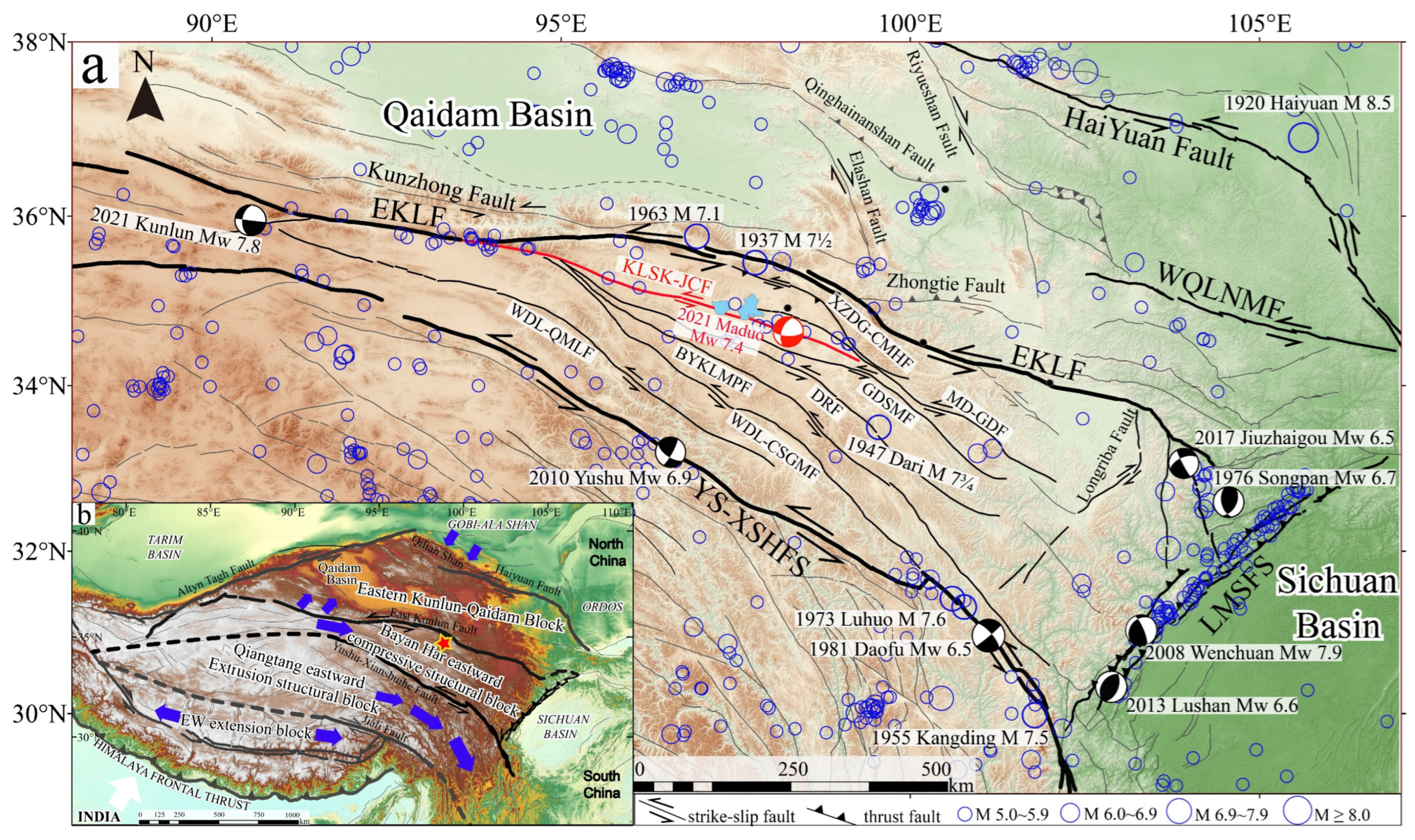
2. Tectonic Setting
3. Data and Methods
4. Results
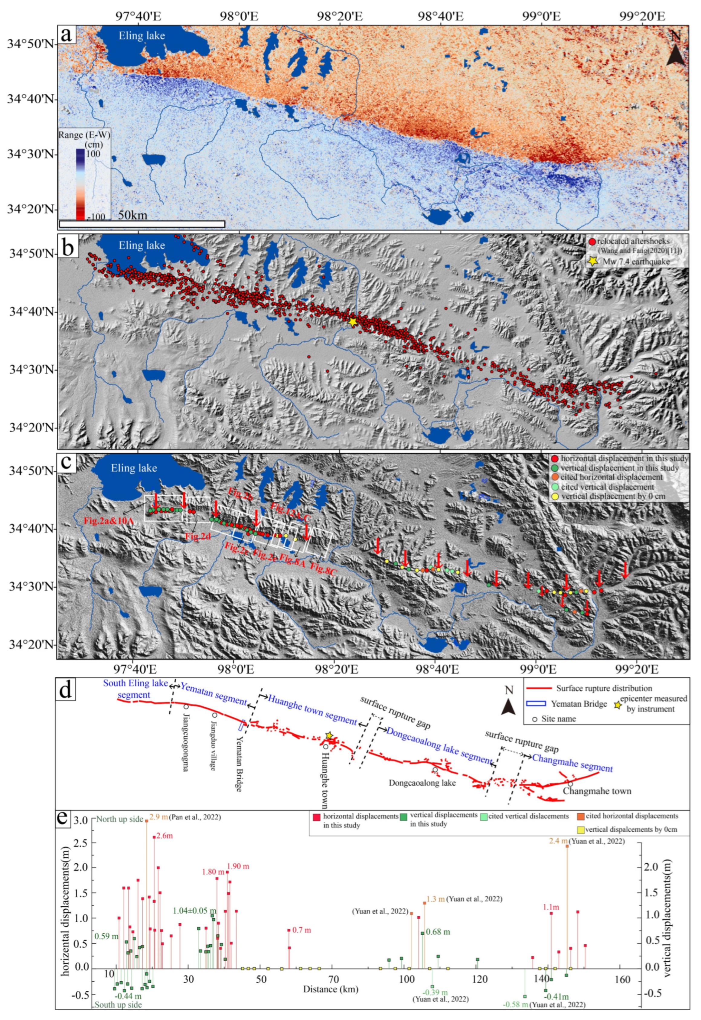
4.1. Segmentation of Surface Rupture of the Maduo Earthquake
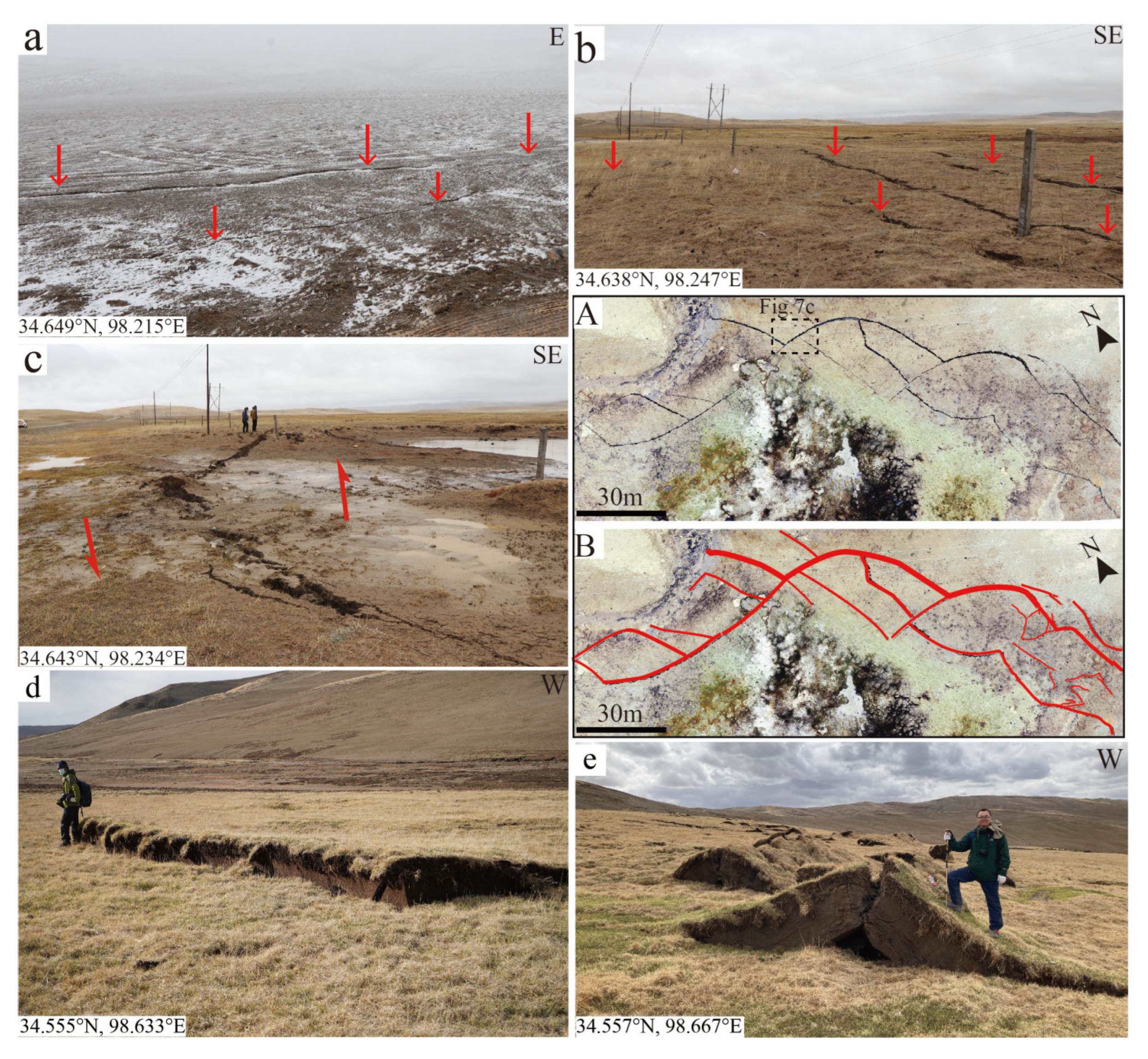
4.2. Characteristics and Morphology of the Co-Seismic Surface Ruptures


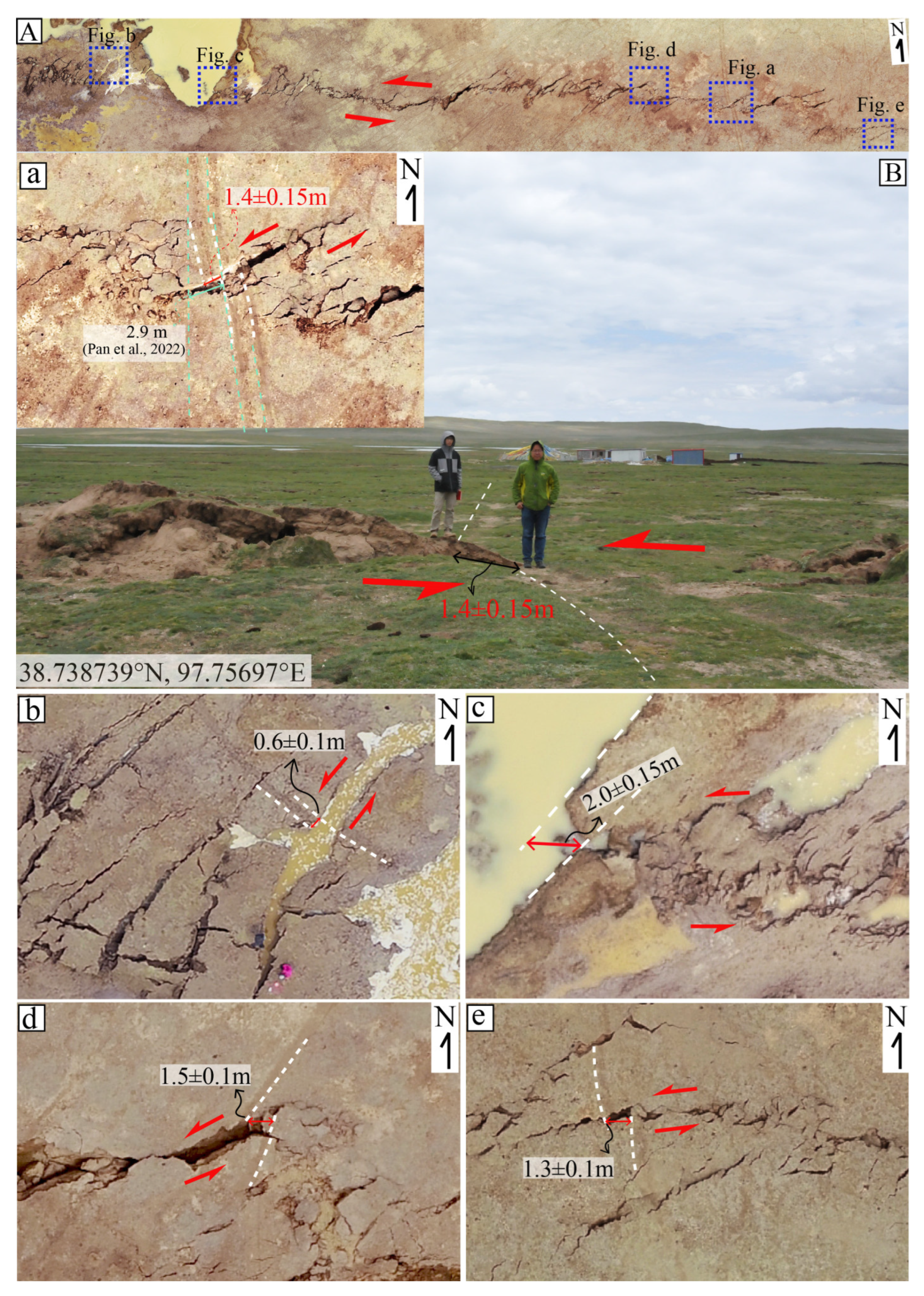
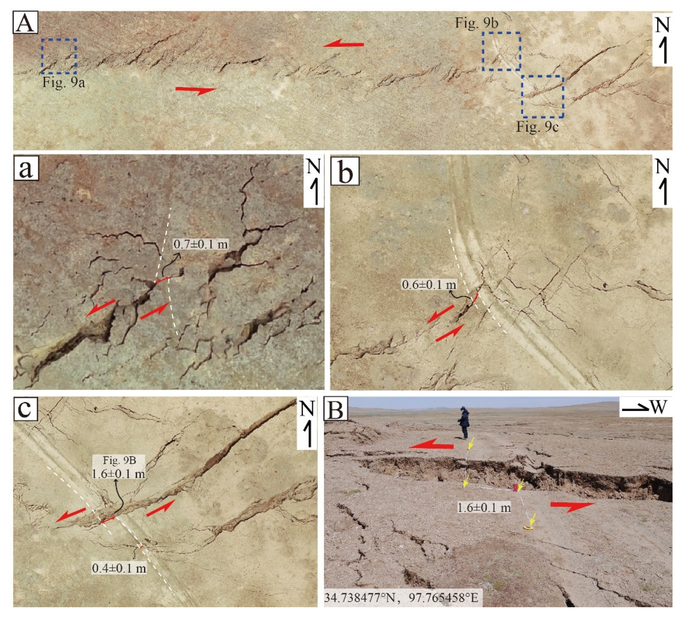
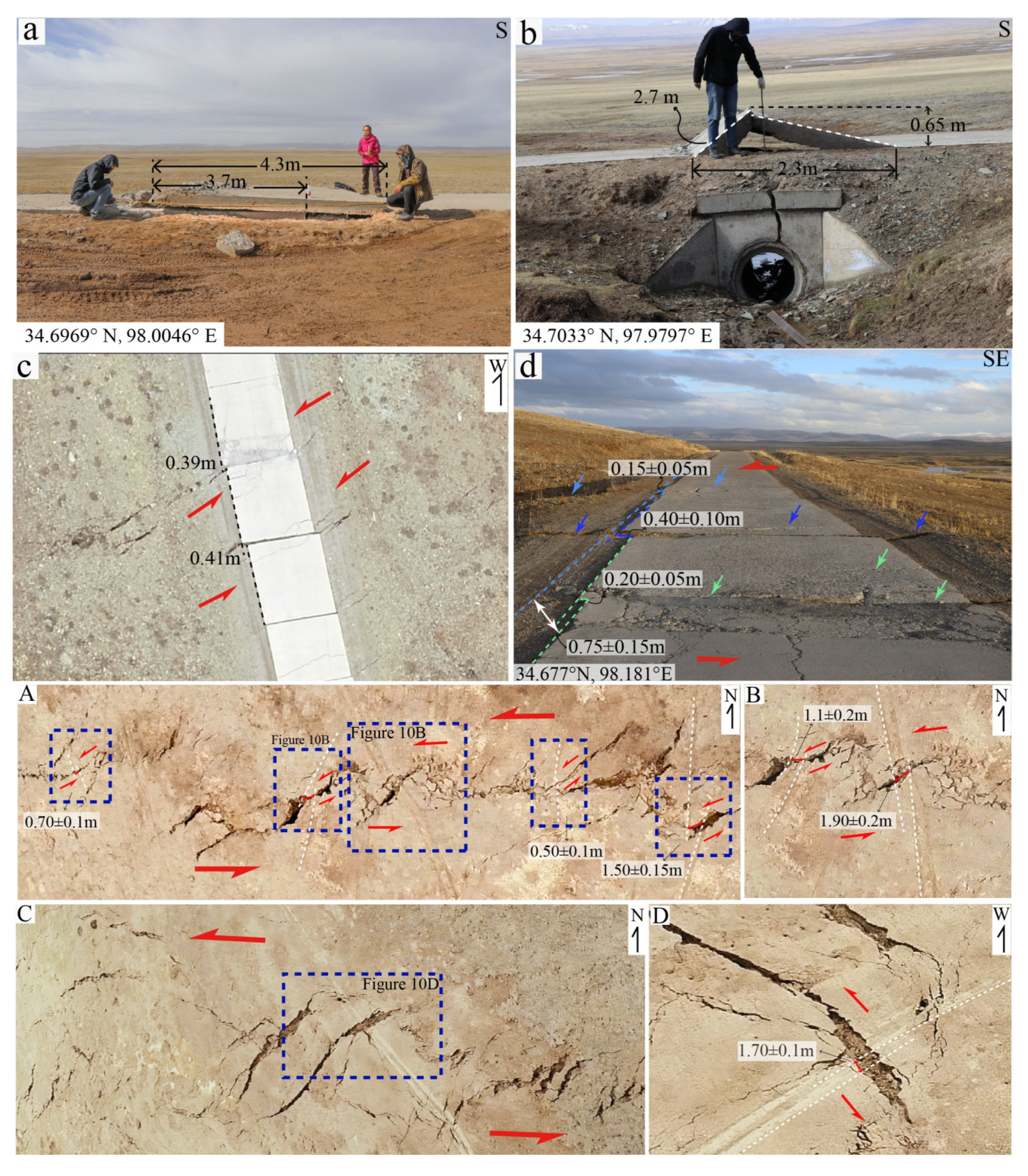
4.3. Co-Seismic Horizontal Displacements
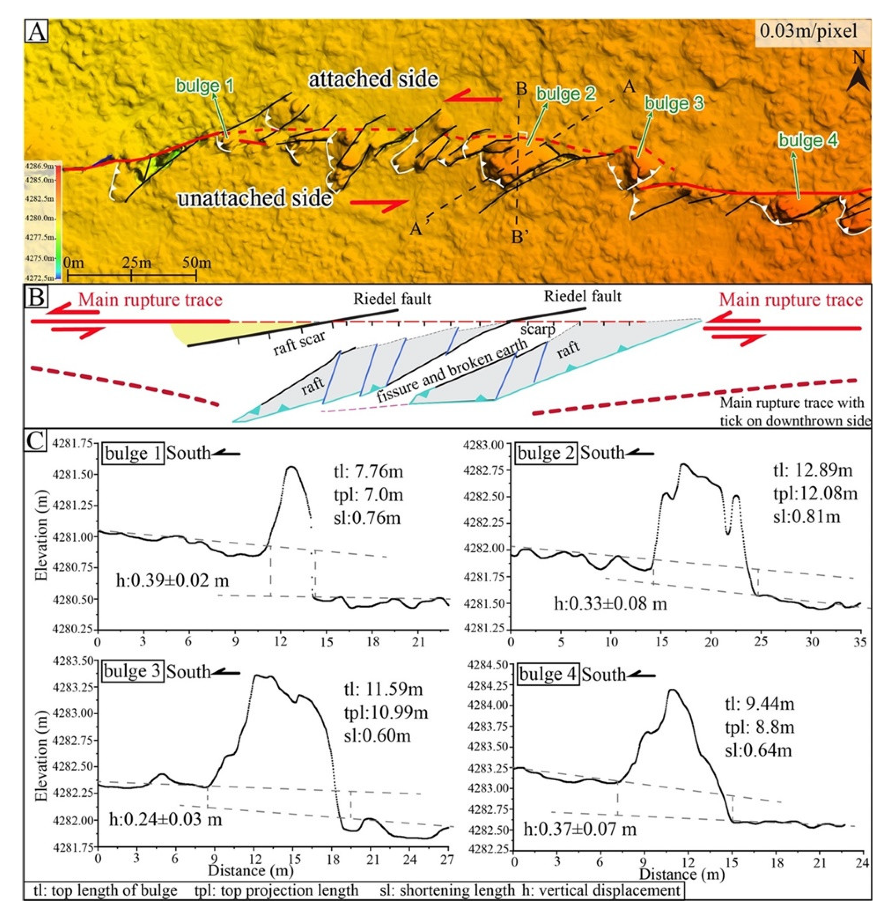
4.4. The Shortening of the Compressive Bulges along the Co-Seismic Surface Rupture of the South Eling Lake Segment
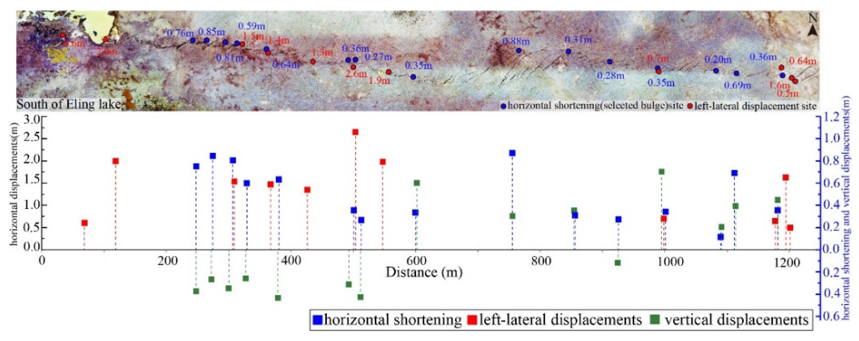
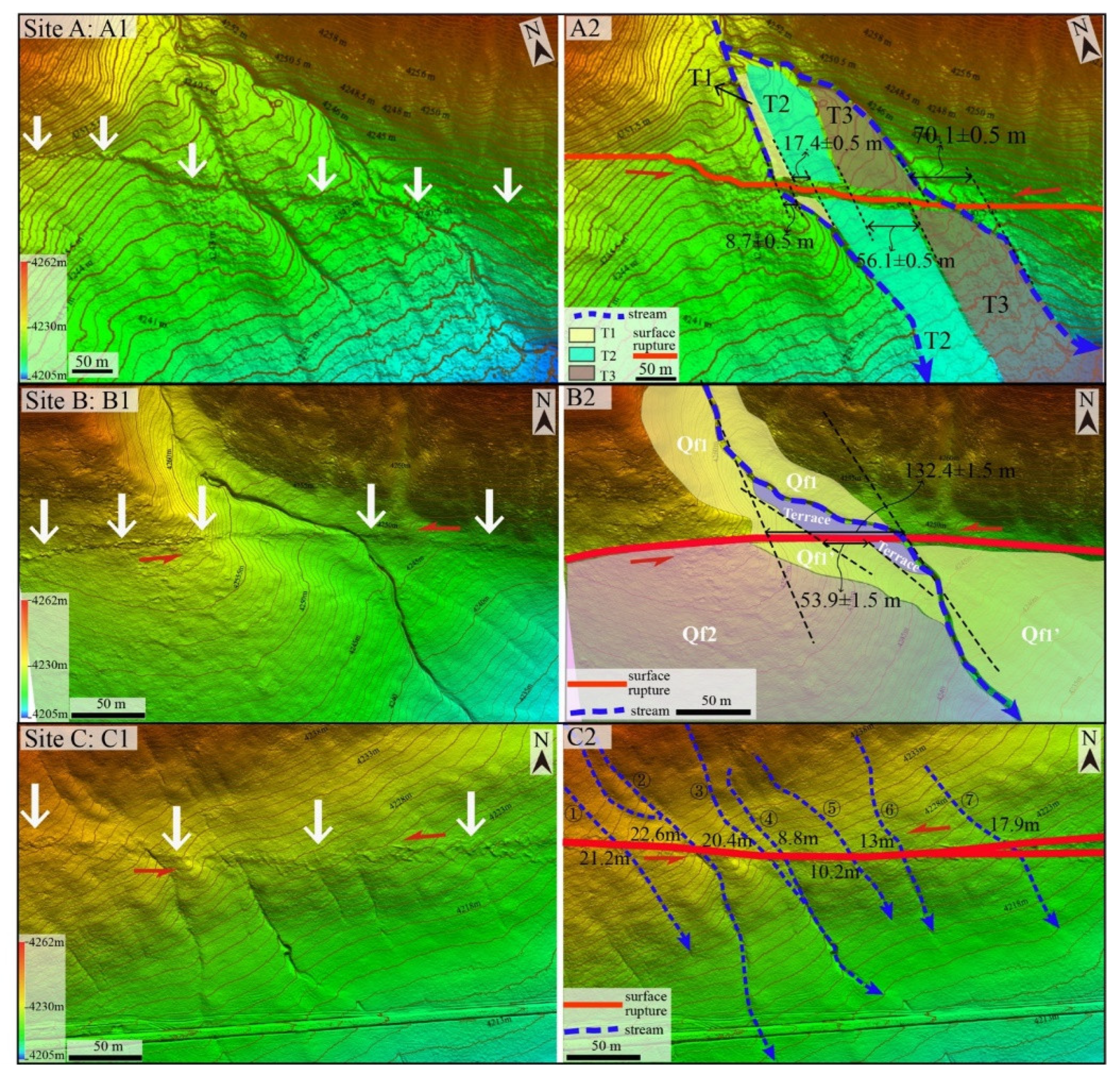
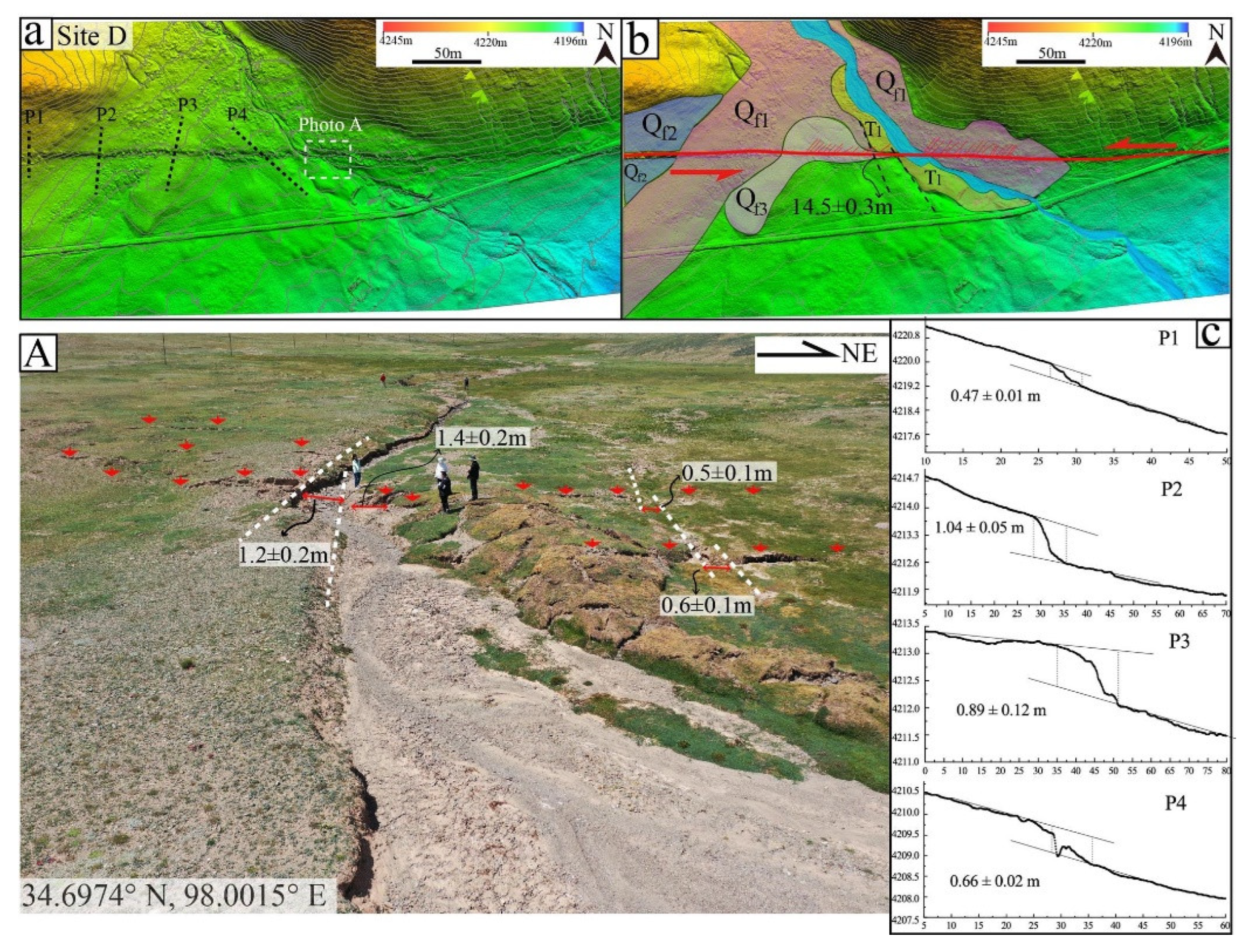
4.5. Cumulative Displacements Associated with the Co-Seismic Surface Rupture
5. Discussion
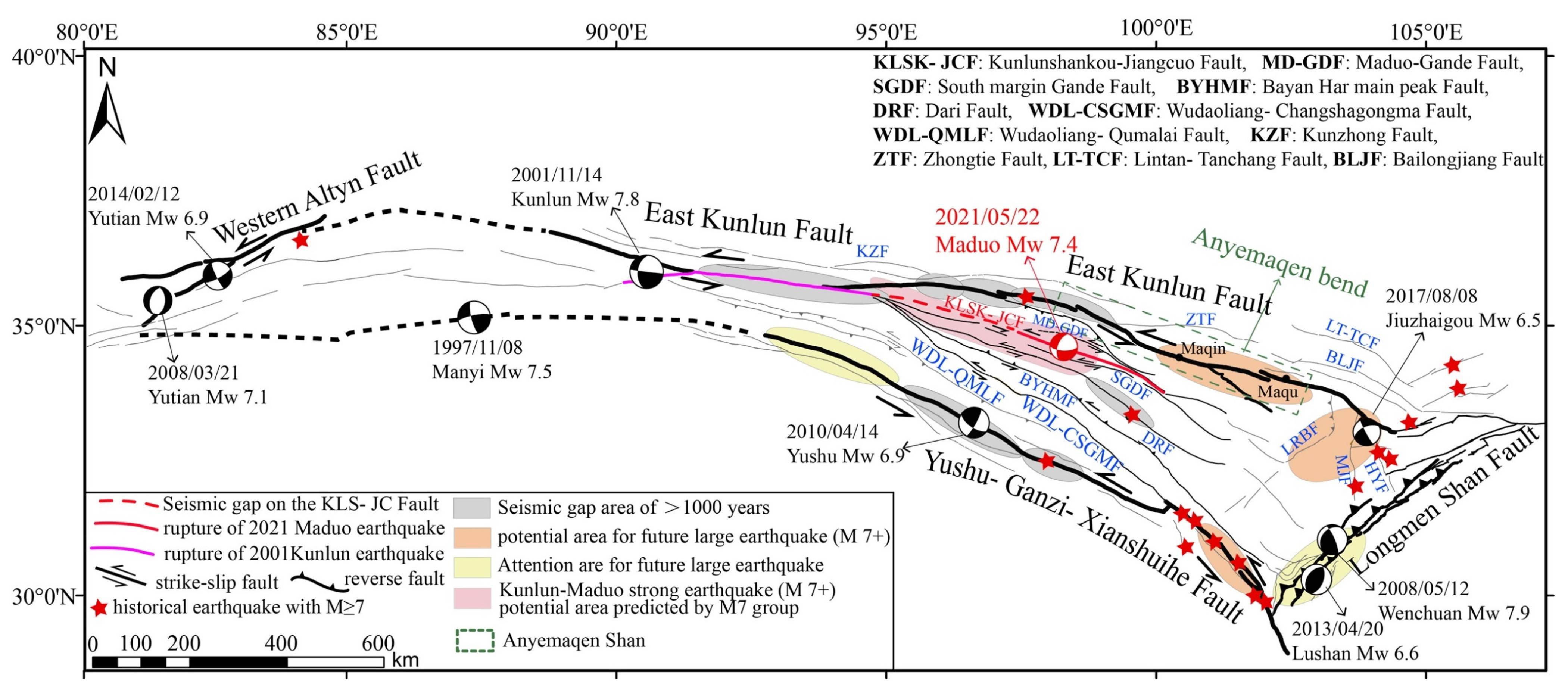
5.1. The Seismic Gap on the Kunlunshankou-Jiangcuo Fault
5.2. The Tectonic Implications of the Bayan Har Block Indicated by the Maduo Earthquake
5.3. Seismic Hazard around the Bayan Har Block
6. Conclusions
- (1)
- The 2021 Mw 7.4 Maduo earthquake produced an NWW-trending ~160 km-long surface rupture stretching from south Eling Lake in the west to Changmahe town in the east. The earthquake occurred as a result of the predominantly left-lateral strike-slip faulting with a component of normal dip-slip. The seismogenic fault is the Kunlunshankou-Jiangcuo Fault, which ruptured the Jiangcuo Fault segment (east segment of KLSK-JCF) in the 2021 Maduo earthquake.
- (2)
- The co-seismic surface rupture mainly consists of distinct shear faults, right stepping en echelon tensional cracks, mole track structures, and widely distributed water blasting, sand liquefaction, and earthquake pits. The maximum sinistral strike-slip displacement is ~2.6 m and the maximum vertical displacement is ~1.5 m.
- (3)
- The deformation of the Bayan Har Block is under the mutual and coordinated control of the main East Kunlun Fault and the other six NW-trending left-lateral strike-slip subfaults (the Maduo-Gande Fault, the Kunlunshankou-Jiangcuo Fault, the Gande south margin Fault, the Dari Fault, the Bayan Har main mountain Fault, and the Wudaoliang-Changshagongma Fault). The main East Kunlun Fault together with these subfaults constitutes a broad and dispersive northern boundary of the Bayan Har Block. The Mw 7.4 Maduo earthquake indicated that the Bayan Har Block still has the potential to produce strong earthquakes of M7+. The Maqin-Maqu segment on the northern boundary, the middle segment of the Xianshuihe Fault, and the Longriba Fault area should be particularly scrutinized for their intermediate-term large earthquake potentials.
Author Contributions
Funding
Data Availability Statement
Acknowledgments
Conflicts of Interest
References
- Klinger, Y.; Xu, X.; Tapponnier, P.; Van der Woerd, J.; Lasserre, C.; King, G. High-Resolution Satellite Imagery Mapping of the Surface Rupture and Slip Distribution of the MW 7.8, 14 November 2001 Kokoxili Earthquake, Kunlun Fault, Northern Tibet, China. Bull. Seism. Soc. Am. 2005, 95, 1970–1987. [Google Scholar] [CrossRef]
- Lin, A.; Ren, Z.; Jia, D.; Wu, X. Co-seismic thrusting rupture and slip distribution produced by the 2008 MW 7.9 Wenchuan earthquake, China. Tectonophysics 2009, 471, 203–215. [Google Scholar] [CrossRef]
- Chen, H.; Qu, C.; Zhao, D.; Ma, C.; Shan, X. Rupture Kinematics and Coseismic Slip Model of the 2021 MW 7.3 Maduo (China) Earthquake: Implications for the Seismic Hazard of the Kunlun Fault. Remote Sens. 2021, 13, 3327. [Google Scholar] [CrossRef]
- Chen, K.; Avouac, J.; Geng, J.; Liang, C.; Zhang, Z.; Li, Z.; Zhang, S. The 2021 MW 7.4 Madoi Earthquake: An Archetype Bilateral Slip-Pulse Rupture Arrested at a Splay Fault. Geophys. Res. Lett. 2022, 49, e2021GL095243. [Google Scholar] [CrossRef]
- Xu, L.; Chen, Q.; Zhao, J.-J.; Liu, X.-W.; Xu, Q.; Yang, Y.-H. An Integrated Approach for Mapping Three-Dimensional CoSeismic Displacement Fields from Sentinel-1 TOPS Data Based on DInSAR, POT, MAI and BOI Techniques: Application to the 2021 MW 7.4 Maduo Earthquake. Remote Sens. 2021, 13, 4847. [Google Scholar] [CrossRef]
- Zhao, D.; Qu, C.; Chen, H.; Shan, X.; Song, X.; Gong, W. Tectonic and Geometric Control on Fault Kinematics of the 2021 MW 7.3 Maduo (China) Earthquake Inferred from Interseismic, Coseismic, and Postseismic InSAR Observations. Geophys. Res. Lett. 2021, 48, e2021GL095417. [Google Scholar] [CrossRef]
- Zhang, X.; Feng, W.; Du, H.; Samsonov, S.; Yi, L. Supershear Rupture During the 2021 MW 7.4 Maduo, China, Earthquake. Geophys. Res. Lett. 2022, 49, e2022GL097984. [Google Scholar] [CrossRef]
- He, L.; Feng, G.; Wu, X.; Lu, H.; Xu, W.; Wang, Y.; Liu, J.; Hu, J.; Li, Z. Coseismic and Early Postseismic Slip Models of the 2021 MW 7.4 Maduo Earthquake (Western China) Estimated by Space-Based Geodetic Data. Geophys. Res. Lett. 2021, 48, e2021GL095860. [Google Scholar] [CrossRef]
- He, K.; Wen, Y.; Xu, C.; Zhao, Y. Fault Geometry and Slip Distribution of the 2021 MW 7.4 Maduo, China, Earthquake Inferred from InSAR Measurements and Relocated Aftershocks. Seism. Res. Lett. 2022, 93, 8–20. [Google Scholar] [CrossRef]
- Jin, Z.; Fialko, Y. Coseismic and Early Postseismic Deformation Due to the 2021 M7.4 Maduo (China) Earthquake. Geophys. Res. Lett. 2021, 48, e2021GL095213. [Google Scholar] [CrossRef]
- Wang, W.; Fang, L.; Wu, J.; Tu, H.; Chen, L.; Lai, G.; Zhang, L. Aftershock sequence relocation of the 2021 MS7.4 Maduo Earthquake, Qinghai, China. Sci. China Earth Sci. 2021, 64, 1371–1380. [Google Scholar] [CrossRef]
- Molnar, P.; Tapponnier, P. Cenozoic Tectonics of Asia: Effects of a Continental Collision: Features of recent continental tectonics in Asia can be interpreted as results of the India-Eurasia collision. Science 1975, 189, 419–426. [Google Scholar] [CrossRef] [PubMed]
- Ren, Z.; Zhang, Z. Structural analysis of the 1997 MW 7.5 Manyi earthquake and the kinematics of the Manyi fault, central Tibetan Plateau. J. Southeast Asian Earth Sci. 2019, 179, 149–164. [Google Scholar] [CrossRef]
- Xu, X.; Yu, G.; Klinger, Y.; Tapponnier, P.; Van Der Woerd, J. Reevaluation of surface rupture parameters and faulting segmentation of the 2001 Kunlunshan earthquake (MW 7.8), northern Tibetan Plateau, China. J. Geophys. Res. Earth Surf. 2006, 111. [Google Scholar] [CrossRef]
- Burchfiel, B.; Royden, L.; Van Der Hilst, R.; Hager, B.; Chen, Z.; King, R.; Li, C.; Lu, J.; Yao, H.; Kirby, E. A geological and geophysical context for the Wenchuan earthquake of 12 May 2008, Sichuan, People’s Republic of China. GSA Today 2008, 18, 4. [Google Scholar] [CrossRef]
- Shen, Z.-K.; Sun, J.; Zhang, P.; Wan, Y.; Wang, M.; Burgmann, R.; Zeng, Y.; Gan, W.; Liao, H.; Wang, Q. Slip maxima at fault junctions and rupturing of barriers during the 2008 Wenchuan earthquake. Nat. Geosci. 2009, 2, 718–724. [Google Scholar] [CrossRef]
- Li, C.-Y.; Pang, J.; Zhang, Z.-Q. Characteristics, Geometry, and Segmentation of the Surface Rupture Associated with the 14 April 2010 Yushu Earthquake, Eastern Tibet, China. Bull. Seism. Soc. Am. 2012, 102, 1618–1638. [Google Scholar] [CrossRef]
- Xu, X.; Wen, X.-Z.; Han, Z.; Chen, G.; Li, C.; Zheng, W.; Zhnag, S.; Ren, Z.; Xu, C.; Tan, X.; et al. Lushan M S7.0 earthquake: A blind reserve-fault event. Chin. Sci. Bull. 2013, 58, 3437–3443. [Google Scholar] [CrossRef]
- Sun, J.; Yue, H.; Shen, Z.; Fang, L.; Zhan, Y.; Sun, X. The 2017 Jiuzhaigou Earthquake: A Complicated Event Occurred in a Young Fault System. Geophys. Res. Lett. 2018, 45, 2230–2240. [Google Scholar] [CrossRef]
- Harkins, N.; Kirby, E.; Shi, X.; Wang, E.; Burbank, D.; Chun, F. Millennial slip rates along the eastern Kunlun fault: Implications for the dynamics of intracontinental deformation in Asia. Lithosphere 2010, 2, 247–266. [Google Scholar] [CrossRef] [Green Version]
- Kirby, E.; Harkins, N.; Wang, E.; Shi, X.; Fan, C.; Burbank, D. Slip rate gradients along the eastern Kunlun fault. Tectonics 2007, 26. [Google Scholar] [CrossRef]
- Liu, J.; Ren, Z.; Zhang, H.; Li, C.; Zhang, Z.; Zheng, W.; Li, X.; Liu, C. Slip Rates Along the Laohushan Fault and Spatial Variation in Slip Rate Along the Haiyuan Fault Zone. Tectonics 2022, 41, e2021TC006992. [Google Scholar] [CrossRef]
- Ren, J.; Xu, X.; Yeats, R.S.; Zhang, S. Millennial slip rates of the Tazang fault, the eastern termination of Kunlun fault: Implications for strain partitioning in eastern Tibet. Tectonophysics 2013, 608, 1180–1200. [Google Scholar] [CrossRef]
- Van der Woerd, J.; Ryerson, F.J.; Tapponnier, P.; Meriaux, A.-S.; Gaudemer, Y.; Meyer, B.; Finkel, R.C.; Caffee, M.W.; Guoguang, Z.; Zhiqin, X. Uniform slip-rate along the Kunlun Fault: Implications for seismic behaviour and large-scale tectonics. Geophys. Res. Lett. 2000, 27, 2353–2356. [Google Scholar] [CrossRef]
- Van Der Woerd, J.; Tapponnier, P.; Ryerson, F.J.; Meriaux, A.-S.; Meyer, B.; Gaudemer, Y.; Finkel, R.C.; Caffee, M.W.; Guoguang, Z.; Xu, Z. Uniform postglacial slip-rate along the central 600 km of the Kunlun Fault (Tibet), from 26Al, 10Be, and 14C dating of riser offsets, and climatic origin of the regional morphology. Geophys. J. Int. 2002, 148, 356–388. [Google Scholar] [CrossRef]
- Li, C.; Lv, L.; Wang, X.; Li, X. Late quaternary slip behavior of the Yushu fault and the 2010 Ms 7.1 Yushu earthquake, eastern Tibetan Plateau. J. Struct. Geol. 2019, 118, 284–298. [Google Scholar] [CrossRef]
- Chen, Z.; Burchfiel, B.C.; Liu, Y.; King, R.W.; Royden, L.H.; Tang, W.; Wang, E.; Zhao, J.; Zhang, X. Global Positioning System measurements from eastern Tibet and their implications for India/Eurasia intercontinental deformation. J. Geophys. Res. Solid Earth 2000, 105, 16215–16227. [Google Scholar] [CrossRef]
- Densmore, A.L.; Ellis, M.A.; Li, Y.; Zhou, R.J.; Hancock, G.S.; Richardson, R. Active tectonics of the Beichuan and Pengguan faults at the eastern margin of the Tibetan Plateau. Tectonics 2007, 26. [Google Scholar] [CrossRef]
- Kirby, E.; Whipple, K.X.; Burchfiel, B.C.; Tang, W.; Berger, G.; Sun, Z.; Chen, Z. Neotectonics of the Min Shan, China: Implications for mechanisms driving Quaternary deformation along the eastern margin of the Tibetan Plateau. GSA Bull. 2000, 112, 375–393. [Google Scholar] [CrossRef]
- Deng, Q.; Ran, Y.; Yang, X.; Min, W.; Chu, Q. Active Tectonic Map of China; Seismological Press: Beijing, China, 2007. (In Chinese) [Google Scholar]
- Tapponnier, P.; Zhiqin, X.; Roger, F.; Meyer, B.; Arnaud, N.; Wittlinger, G.; Jingsui, Y. Oblique Stepwise Rise and Growth of the Tibet Plateau. Science 2001, 294, 1671–1677. [Google Scholar] [CrossRef]
- Xiong, R.; Ren, J.; Zhang, J.; Yang, P.; Li, Z. Late Quaternary active characteristics of the Gande segment in the Maduo-Gande fault zone. Earthquake 2010, 30, 65–73. (In Chinese) [Google Scholar] [CrossRef]
- Liang, M.; Yang, Y.; Du, F.; Gong, Y.; Sun, W.; Zhao, M.; He, Q. Late Quaternary activity of the central segment of the Dari fault and restudy of the surface rupture zone of the 1947 M7¾ Dari earthquake, Qinghai Province. Seismol. Geol. 2020, 42, 703–714. (In Chinese) [Google Scholar] [CrossRef]
- Ren, Z.; Zielke, O.; Yu, J. Active tectonics in 4D high-resolution. J. Struct. Geol. 2018, 117, 264–271. [Google Scholar] [CrossRef]
- Yuan, Z.; Li, T.; Su, P.; Sun, H.; Ha, G.; Guo, P.; Chen, G.; Jobe, J.T. Large Surface-Rupture Gaps and Low Surface Fault Slip of the 2021 MW 7.4 Maduo Earthquake Along a Low-Activity Strike-Slip Fault, Tibetan Plateau. Geophys. Res. Lett. 2022, 49, e2021GL096874. [Google Scholar] [CrossRef]
- Pan, J.; Li, H.; Chevalier, M.-L.; Tapponnier, P.; Bai, M.; Li, C.; Liu, F.; Liu, D.; Wu, K.; Wang, P.; et al. Co-seismic rupture of the 2021, M 7.4 Maduo earthquake (Northern Tibet): Short-cutting of the Kunlun fault big bend. Earth Planet. Sci. Lett. 2022, 594, 117703. [Google Scholar] [CrossRef]
- Working Group of M7. Study on the Mid-to-Long Term Potential of Large Earthquake on the China Continent; Seismological Press: Beijing, China, 2021; pp. 233–238. (In Chinese) [Google Scholar]
- Pan, J.; Bai, M.; Li, C.; Liu, F.; Li, H.; Liu, D.; Chevalier, M.-L.; Wu, K.; Wang, P.; Lu, H.; et al. Coseismic surface rupture and seismogenic structure of the 2021-05-22 Maduo(Qinghai) Ms 7.4 earthquake. Acta Geologica Sinica. 2021, 95, 1655–1670. (In Chinese) [Google Scholar] [CrossRef]
- Kirby, E.; Harkins, N. Distributed deformation around the eastern tip of the Kunlun fault. Geol. Rundsch. 2013, 102, 1759–1772. [Google Scholar] [CrossRef]
- Su, Q.; Wang, X.; Yuan, D.; Zhang, H.; Lu, H.; Xie, H. Secondary faulting plays a key role in regulating the Cenozoic crustal deformation in the northeastern Qinghai-Tibet Plateau. Terra Nova 2022, 34, 231–243. [Google Scholar] [CrossRef]
- Yang, Z.; Zhao, D.; Dong, Y.; Cheng, B. Crustal flow and fluids affected the 2021 M7.4 Maduo earthquake in Northeast Tibet. J. Southeast Asian Earth Sci. 2021, 225, 105050. [Google Scholar] [CrossRef]
- Qi-Dong, D.; Shao-Ping, C.; Ji, M.; Peng, D. Seismic Activities and Earthquake Potential in the Tibetan Plateau. Chin. J. Geophys. 2014, 57, 678–697. [Google Scholar] [CrossRef]
- Wang, M.; Wang, F.; Jiang, X.; Tian, J.; Li, Y.; Sun, J.; Shen, Z.-K. GPS determined coseismic slip of the 2021 MW 7.4 Maduo, China, earthquake and its tectonic implication. Geophys. J. Int. 2022, 228, 2048–2055. [Google Scholar] [CrossRef]
- Van Der Woerd, J.; Ryerson, F.J.; Tapponnier, P.; Gaudemer, Y.; Finkel, R.; Meriaux, A.-S.; Caffee, M.; Guoguang, Z.; Qunlu, H. Holocene left-slip rate determined by cosmogenic surface dating on the Xidatan segment of the Kunlun fault (Qinghai, China). Geology 1998, 26, 695–698. [Google Scholar] [CrossRef]
- Li, C.-F.; He, Q.-L.; Zhao, G.-G. Paleo-earthquake studies on the eastern section of the Kunlun fault. Acta Seism. Sin. 2005, 18, 64–71. [Google Scholar] [CrossRef]
- Junlong, Z. On fault evidence for a large earthquake in the late fifteenth century, Eastern Kunlun fault, China. J. Seism. 2017, 21, 1397–1405. [Google Scholar] [CrossRef]

Publisher’s Note: MDPI stays neutral with regard to jurisdictional claims in published maps and institutional affiliations. |
© 2022 by the authors. Licensee MDPI, Basel, Switzerland. This article is an open access article distributed under the terms and conditions of the Creative Commons Attribution (CC BY) license (https://creativecommons.org/licenses/by/4.0/).
Share and Cite
Xie, H.; Li, Z.; Yuan, D.; Wang, X.; Su, Q.; Li, X.; Wang, A.; Su, P. Characteristics of Co-Seismic Surface Rupture of the 2021 Maduo Mw 7.4 Earthquake and Its Tectonic Implications for Northern Qinghai–Tibet Plateau. Remote Sens. 2022, 14, 4154. https://doi.org/10.3390/rs14174154
Xie H, Li Z, Yuan D, Wang X, Su Q, Li X, Wang A, Su P. Characteristics of Co-Seismic Surface Rupture of the 2021 Maduo Mw 7.4 Earthquake and Its Tectonic Implications for Northern Qinghai–Tibet Plateau. Remote Sensing. 2022; 14(17):4154. https://doi.org/10.3390/rs14174154
Chicago/Turabian StyleXie, Hong, Zhimin Li, Daoyang Yuan, Xianyan Wang, Qi Su, Xin Li, Aiguo Wang, and Peng Su. 2022. "Characteristics of Co-Seismic Surface Rupture of the 2021 Maduo Mw 7.4 Earthquake and Its Tectonic Implications for Northern Qinghai–Tibet Plateau" Remote Sensing 14, no. 17: 4154. https://doi.org/10.3390/rs14174154
APA StyleXie, H., Li, Z., Yuan, D., Wang, X., Su, Q., Li, X., Wang, A., & Su, P. (2022). Characteristics of Co-Seismic Surface Rupture of the 2021 Maduo Mw 7.4 Earthquake and Its Tectonic Implications for Northern Qinghai–Tibet Plateau. Remote Sensing, 14(17), 4154. https://doi.org/10.3390/rs14174154