The authors wish to make the following corrections to this paper [1]:
In the original article, there was a mistake in Figure 3 as published. During the review process, the reviewer recommends using the percentages of the changes to replace the specific number changes of the area of subsidence exceeding 50 mm among the three sub-plains (Section 4.1, Paragraph 2). Therefore, we revised the relevant text based on the reviewer’s suggestion. Moreover, the specific number changes are shown by Figure 3c. However, due to our negligence, Figure 3c did not use the latest version in the online version. And which leads to the difference between the area of subsidence exceeding 50 mm in Figure 3c and the area of subsidence exceeding 50 mm in Paragraph 2 (Section 4.1). To avoid misunderstanding, we intend to revise Figure 3. The corrected Figure 3 appears below. The authors apologize for any inconvenience caused and state that the scientific conclusions are unaffected. The original article has been updated.
Replace
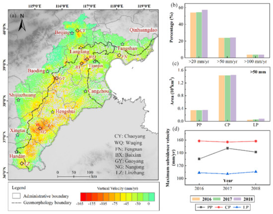
Figure 3.
(a) Mean vertical displacement velocities throughout the NCP derived from the Sentinel-1A (S1A) data by using persistent scatterer interferometric synthetic aperture radar (PS-InSAR), (b) statistics of the subsidence rates at persistent scatterer (PS) points, (c) changes in the area with subsidence over 50 mm from 2016 to 2018, and (d) changes in the maximum subsidence rates from 2016 to 2018: PP, CP, and LP represent the piedmont alluvial-proluvial plain, central alluvial-lacustrine plain, and littoral plain, respectively.
With
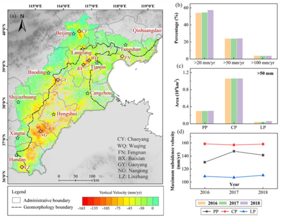
Figure 3.
(a) Mean vertical displacement velocities throughout the NCP derived from the Sentinel-1A (S1A) data by using persistent scatterer interferometric synthetic aperture radar (PS-InSAR), (b) statistics of the subsidence rates at persistent scatterer (PS) points, (c) changes in the area with subsidence over 50 mm from 2016 to 2018, and (d) changes in the maximum subsidence rates from 2016 to 2018: PP, CP, and LP represent the piedmont alluvial-proluvial plain, central alluvial-lacustrine plain, and littoral plain, respectively.
Conflicts of Interest
The authors declare no conflict of interest.
Reference
- Shi, M.; Gong, H.; Gao, M.; Chen, B.; Zhang, S.; Zhou, C. Recent Ground Subsidence in the North China Plain, China, Revealed by Sentinel-1A Datasets. Remote Sens. 2020, 12, 3579. [Google Scholar] [CrossRef]
Publisher’s Note: MDPI stays neutral with regard to jurisdictional claims in published maps and institutional affiliations. |
© 2021 by the authors. Licensee MDPI, Basel, Switzerland. This article is an open access article distributed under the terms and conditions of the Creative Commons Attribution (CC BY) license (http://creativecommons.org/licenses/by/4.0/).