
GPS-Based Multi-Temporal Variation in Precipitable Water over the Territory of Poland

 , , and
Abstract
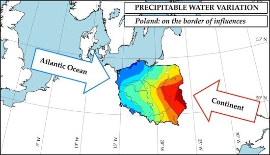
1. Introduction
2. Materials and Methods
3. Results
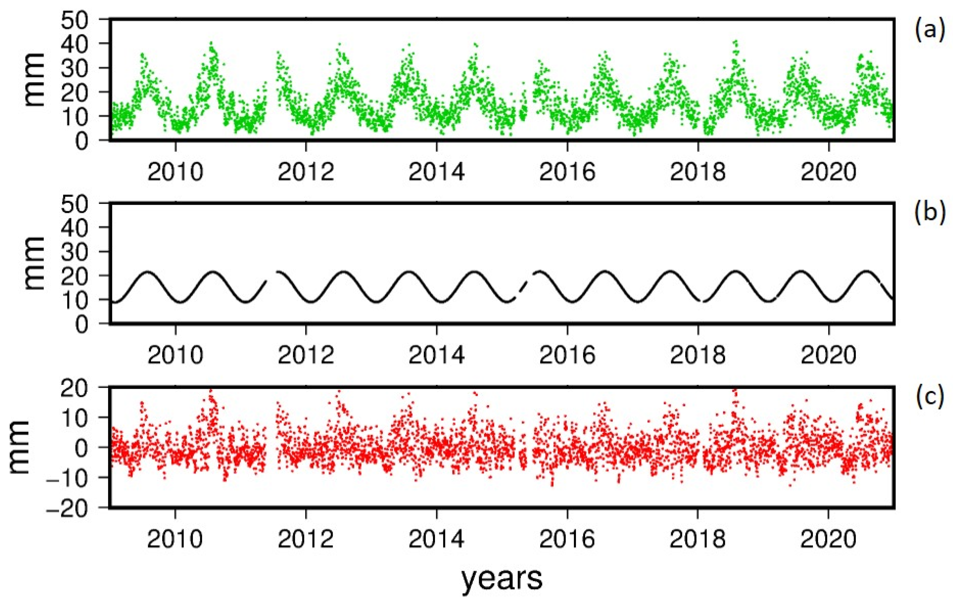
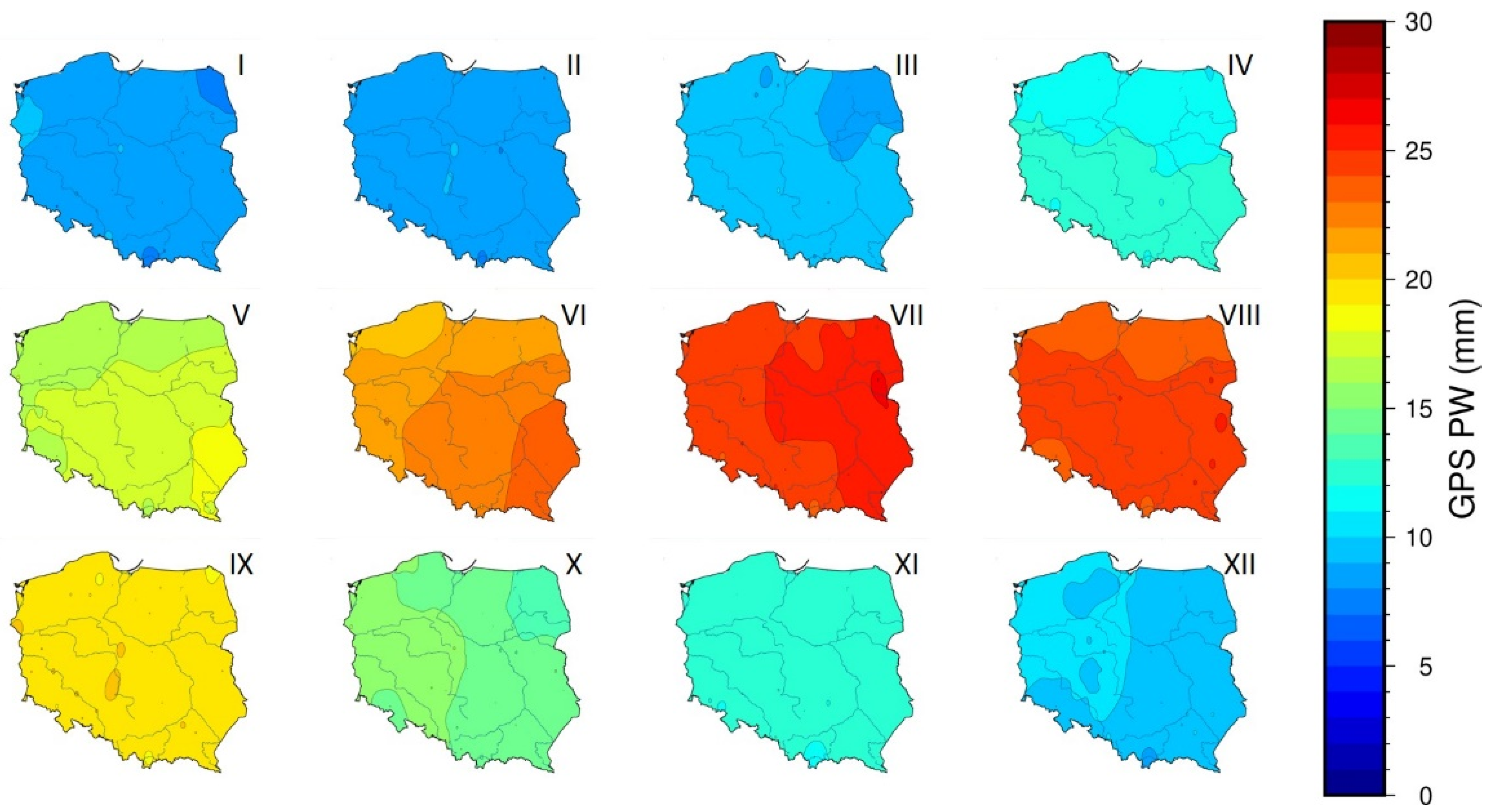
3.1. General Statistics on the GPS PW Changes
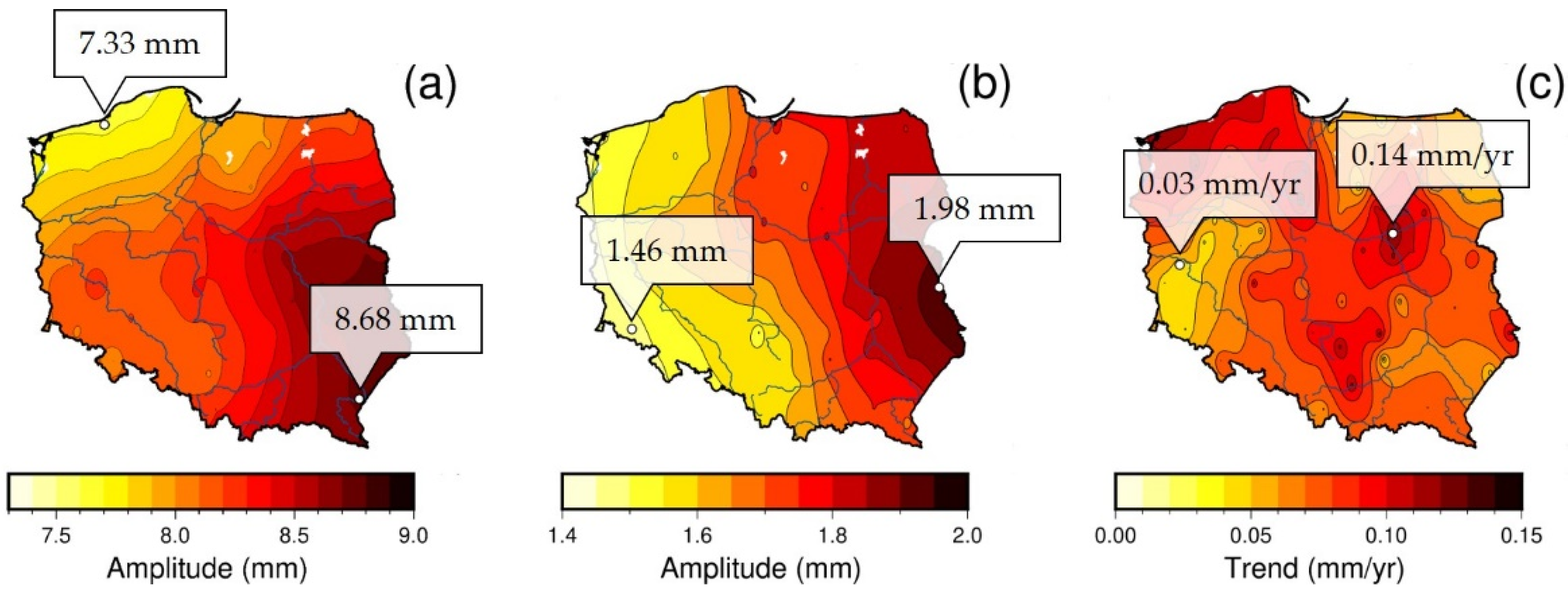
3.2. Longterm Variation of PW
3.3. Comparison with the RS Data
4. Discussion
5. Conclusions
Author Contributions
Funding
Institutional Review Board Statement
Informed Consent Statement
Data Availability Statement
Acknowledgments
Conflicts of Interest
References
- Arnell, N.W.; Lowe, J.A.; Challinor, A.J.; Osborn, T.J. Global and regional impacts of climate change at different levels of global temperature increase. Clim. Chang. 2019, 155, 377–391. [Google Scholar] [CrossRef]
- Stocker, T.F.; Qin, D.; Plattner, G.-K.; Tignor, M.; Allen, S.K.; Boschung, J.; Nauels, A.; Xia, Y.; Bex, V.; Midgley, P.M. (Eds.) IPCC, 2013: Climate Change 2013: The Physical Science Basis. Contribution of Working Group I to the Fifth Assessment Report of the Intergovern-mental Panel on Climate Change; Cambridge University Press: Cambridge, UK; New York, NY, USA, 2013; p. 1535. [Google Scholar]
- PAGES 2k Consortium. Consistent multidecadal variability in global temperature reconstructions and simulations over the Common Era. Nat. Geosci. 2019, 12, 643–649. [Google Scholar] [CrossRef] [PubMed]
- Hawkins, E.; Ortega, P.; Suckling, E.; Schurer, A.; Heherl, G.; Jones, P.; Joshi, M.; Osborn, J.T.; Masson-Delmotte, V.; Mignot, J.; et al. Estimating changes in global temperature since the preindustrial period. Bull. Am. Meteorol. Soc. 2017, 98, 1841–1856. [Google Scholar] [CrossRef]
- Glossary of American Meteorological Society. Available online: https://glossary.ametsoc.org/wiki/Precipitable_water (accessed on 30 June 2021).
- Kożuchowski, K. Annual course of the abundance of precipitation in Poland. Prz. Geofiz. 2015, 60, 27–38. (In Polish) [Google Scholar]
- Kożuchowski, K. Atmospheric precipitable water and precipitations in Poland. Prz. Geofiz. 2016, 61, 151–169. (In Polish) [Google Scholar]
- Richling, A.; Ostaszewska, K. Geografia Fizyczna Polski; State Scientific Publishers, PWN: Warszawa, Poland, 2005. (In Polish) [Google Scholar]
- Kożuchowski, K. Klimat Polski. Nowe Spojrzenie; State Scientific Publishers, PWN: Warszawa, Poland, 2011. (In Polish) [Google Scholar]
- Troller, M.; Geiger, A.; Brockmann, E.; Kahle, H.-G. Determination of the spatial and temporal variation of tropospheric water vapour using CGPS networks. Geophys. J. Int. 2006, 167, 509–520. [Google Scholar] [CrossRef]
- Bevis, M.; Businger, S.; Herring, T.A.; Rocken, C.; Anthes, R.A.; Ware, R.H. GPS meteorology: Remote sensing of atmospheric water vapour using the global positioning system. J. Geophys. Res. 1992, 15787–15801. [Google Scholar] [CrossRef]
- Bar-Sever, Y.E.; Kroger, P.M.; Borjesson, J.A. Estimating horizontal gradients of tropospheric path delay with a single GPS receiver. J. Geophys. Res. 1998, 103, 5019–5035. [Google Scholar] [CrossRef]
- Li, X.; Zus, F.; Lu, C.; Dick, G.; Ning, T.; Ge, M.; Wickert, J.; Schuh, H. Retrieving of atmospheric parameters from multi-GNSS in real time: Validation with water vapour radiometer and numerical weather model. J. Geophys. Res. Atmos. 2015. [Google Scholar] [CrossRef]
- Zus, F.; Douša, J.; Kačmařík, M.; Václavovic, P.; Balidakis, K.; Dick, G.; Wickert, J. Improving GNSS Zenith Wet Delay Interpolation by Utilizing Tropospheric Gradients: Experiments with a Dense Station Network in Central Europe in the Warm Season. Remote Sens. 2019, 11, 674. [Google Scholar] [CrossRef]
- He, Q.; Shen, Z.; Wan, M.; Li, L. Precipitable Water Vapour Converted from GNSS-ZTD and ERA5 Datasets for the Monitoring of Tropical Cyclones. IEEE Access 2020, 8, 87275–87290. [Google Scholar] [CrossRef]
- Ejigu, Y.G.; Teferle, F.N.; Klos, A.; Bogusz, J.; Hunegnaw, A. Monitoring and prediction of hurricane tracks using GPS tropospheric products. GPS Solut. 2021, 25, 76. [Google Scholar] [CrossRef]
- Stepniak, K.; Bock, O.; Wielgosz, P. Reduction of ZTD outliers through improved GNSS data processing and screening strategies. Atmos. Meas. Tech. 2018, 11, 1347–1361. [Google Scholar] [CrossRef]
- Nykiel, G.; Figurski, M.; Baldysz, Z. Analysis of GNSS sensed precipitable water vapour and tropospheric gradients during the derecho event in Poland of 11th August 2017. J. Atmos. Sol. Terr. Phys. 2019, 193, 1–14. [Google Scholar] [CrossRef]
- Hadas, T.; Kaplon, J.; Bosy, J.; Sierny, J.; Wilgan, K. Near-real-time regional troposphere models for the GNSS precise point positioning technique. Meas. Sci. Technol. 2013, 24, 055003. [Google Scholar] [CrossRef]
- Tondas, D.; Kapłon, J.; Rohm, W. Ultra-fast near real-time estimation of troposphere parameters and coordinates from GPS data. Measurement 2020, 162, 107849. [Google Scholar] [CrossRef]
- Łos, M.; Smolak, K.; Guerova, G.; Rohm, W. GNSS-Based Machine Learning Storm Nowcasting. Remote Sens. 2020, 12, 2536. [Google Scholar] [CrossRef]
- Araszkiewicz, A.; Brockmann, E.; Dousa, J. EPN-Repro2: A reference GNSS tropospheric data set over Europe. Atmos. Meas. Tech. 2017, 10, 1689–1705. [Google Scholar] [CrossRef]
- Baldysz, Z.; Nykiel, G.; Figurski, M.; Szafranek, K.; Kroszczynski, K. Investigation of the 16-year and 18-year ZTD Time Series Derived from GPS DATA Processing. Acta Geophys. 2015, 63, 1103–1125. [Google Scholar] [CrossRef]
- Baldysz, Z.; Nykiel, G.; Araszkiewicz, A.; Figurski, M.; Szafranek, K. Comparison of GPS tropospheric delays derived from two consecutive EPN reprocessing campaigns from the point of view of climate monitoring. Atmos. Meas. Tech. 2016, 9, 4861–4877. [Google Scholar] [CrossRef]
- Baldysz, Z.; Nykiel, G.; Figurski, M.; Araszkiewicz, A. Assessment of the Impact of GNSS Processing Strategies on the Long-Term Parameters of 20 Years IWV Time Series. Remote Sens. 2018, 10, 496. [Google Scholar] [CrossRef]
- Bosy, J.; Graszka, W.; Leończyk, M. ASG-EUPOS. A Multifunctional Precise Satellite Positioning System in Poland. Eur. J. Navig. 2007, 5, 2–6. [Google Scholar]
- Liwosz, T.; Ryczywolski, M. Verification of the Polish geodetic reference frame by means of a new solution based on permanent GNSS data from the years 2011-2014. Rep. Geod. Geoinform. 2016, 102, 52–66. [Google Scholar] [CrossRef][Green Version]
- Herring, T.A.; King, R.W.; Floyd, A.; McClusky, S.C. Documentation for the GAMIT GPS Analysis Software 10,70; Massachusetts Institute of Technology Internal Report; Massachusetts Institute of Technology: Cambridge, MA, USA, 2018. [Google Scholar]
- Bruyninx, C.; Legrand, J.; Fabian, A.; Pottiaux, E. GNSS metadata and data validation in the EUREF Permanent Network. GPS Solut. 2019, 23, 106. [Google Scholar] [CrossRef]
- Araszkiewicz, A.; Voelksen, C. The impact of the antenna phase center models on the coordinates in the EUREF Permanent Network. GPS Solut. 2017, 21, 747–757. [Google Scholar] [CrossRef]
- Boehm, J.; Werl, B.; Schuh, H. Troposphere mapping functions for GPS and very long baseline interferometry from European Centre for Medium-Range Weather Forecasts operational analysis data. J. Geophys. Res. 2006, 111, B02406. [Google Scholar] [CrossRef]
- Hersbach, H.; Bell, B.; Berrisford, P.; Biavati, G.; Horányi, A.; Muñoz Sabater, J.; Nicolas, J.; Peubey, C.; Radu, R.; Rozum, I.; et al. ERA5 hourly data on single levels from 1979 to present. Copernic. Clim. Chang. Serv. Clim. Data Store 2018. [Google Scholar] [CrossRef]
- Polish Climate Monitoring Bulletin 2019; Institute of Meteorology and Water Management—National Research Institute: Warsaw, Poland, 2020.
- Witek, M.; Bednorz, E.; Forycka-Lawniczak, H. Kontynentalizm termiczny w Europie. Bad. Fizjogr. 2015, A, 171–182. (In Polish) [Google Scholar] [CrossRef]
- Lorenc, H. Atlas klimatu Polski; Institute of Meteorology and Water Management: Warsaw, Poland, 2005; ISBN 83-88897-43-8. (In Polish) [Google Scholar]
- Schwartz, B.; Govett, M. A Hydrostatically Consistent North American Radiosonde Data Base at the Forecast Systems Laboratory, 1946-Present, Forecast Systems Laboratory, Boulder Colorado, 1992. Available online: https://ruc.noaa.gov/raobs/radiosonde.pdf (accessed on 20 June 2021).
- Stull, R. Practical Meteorology: An Algebra-Based Survey of Atmospheric Science; The University of British Columbia: Vancouver, BC, Canada, 2016. [Google Scholar]
- Kottek, M.; Grieser, J.; Beck, C.; Rudolf, B.; Rubel, F. World map of the Köppen-Geiger climate classification updated. Meteorol. Z. 2006, 15, 259–263. [Google Scholar] [CrossRef]
- Cedro, A.; Walczakiewicz, S. Podstawy meteorologii i klimatologii Polski. In Odnawialne Źródła Energii w Polsce ze Szczególnym Uwzględnieniem Województwa Zachodniopomorskiego; Swiatek, M., Cedro, A., Eds.; ZAPOL: Szczecin, Poland, 2017. (In Polish) [Google Scholar]
- Okołowicz, W.; Martyn, D. Regiony klimatyczne Polski. In Atlas Geograficzny Polski; Polish Cartographic Publishers PPWK: Warsaw, Poland, 1979. (In Polish) [Google Scholar]
- Wypych, A.; Bochenek, B.; Różycki, M. Atmospheric Moisture Content over Europe and the Northern Atlantic. Atmosphere 2018, 9, 18. [Google Scholar] [CrossRef]
- Kruczyk, M. Long Series of GNSS Integrated Precipitable Water as a Climate Change Indicator. Rep. Geod. Geoinform. 2016, 99, 1–18. [Google Scholar] [CrossRef]
- NOAA National Centers for Environmental Information, State of the Climate: Global Climate Report for Annual 2020, Published Online January 2021. Available online: https://www.ncdc.noaa.gov/sotc/global/202013 (accessed on 28 June 2021).
- Oke, T.R. City size and the urban heat island. Atmos. Environ. 1967, 7, 769–779. [Google Scholar] [CrossRef]
- Bulletin of The National Hydrological and Meteorological Service: October 2010; Institute of Meteorology and Water Management: Warsaw, Poland, 2010; Volume 10, Available online: https://danepubliczne.imgw.pl/data/dane_pomiarowo_obserwacyjne/Biuletyn_PSHM/Biuletyn_PSHM_2010_10_(pazdziernik).pdf (accessed on 29 June 2021).
- Wessel, P.; Luis, J.F.; Uieda, L.; Scharroo, R.; Wobbe, F.; Smith, W.H.F.; Tian, D. The Generic Mapping Tools version 6. Geochem. Geophys. Geosyst. 2019, 20, 5556–5564. [Google Scholar] [CrossRef]


| Group | Parameter Notes |
|---|---|
| Software | GAMIT |
| Observations | GPS, ionosphere-free code and phase combination |
| Orbits | IGS08 1, IGS14 |
| Antenna models | transmitters: IGS08 1, IGS14 receivers: individual calibrations for ASG-EUPOS and selected EPN stations, IGS08 1, IGS14 for rest |
| Clocks | Estimated |
| Ionosphere | “iono-free” + higher order |
| Troposphere | VMF1 as an a priori, 1 h ZTD estimated and 24 h gradient |
| Tide displacement | IERS2010, FES2004 |
| Non-tidal displacement | None |
| Param. | I | II | III | IV | V | VI | VII | VIII | IX | X | XI | XII |
|---|---|---|---|---|---|---|---|---|---|---|---|---|
| Mean (mm) | 8.48 | 8.06 | 9.92 | 11.32 | 16.48 | 21.21 | 23.83 | 23.04 | 18.05 | 13.58 | 11.29 | 8.88 |
| St. dev. (mm) | 0.58 | 1.94 | 1.93 | 2.70 | 3.55 | 4.58 | 5.64 | 5.43 | 5.24 | 3.99 | 3.67 | 2.92 |
| Parameters | GPS: REDZ RS: 12,120 | GPS: BOGI RS: 12,374 | GPS: BOGO RS: 12,374 | GPS: WROC RS: 12,425 | ||||
|---|---|---|---|---|---|---|---|---|
| Distance (km) | 42 | 8 | 8 | 13 | ||||
| Bias (mm) and std. (mm) | −0.08 ± 3.28 | −0.35 ± 3.47 | −0.36 ± 3.46 | −1.21 ± 3.36 | ||||
| GNSS | RS | GNSS | RS | GNSS | RS | GNSS | RS | |
| St. dev. (mm) | 4.76 | 4.03 | 5.17 | 4.13 | 5.18 | 4.13 | 4.85 | 3.97 |
| Annual (mm) | 7.64 | 7.61 | 8.61 | 7.61 | 8.54 | 7.61 | 8.23 | 7.33 |
| Semi-annual (mm) | 1.57 | 1.41 | 1.78 | 1.30 | 1.76 | 1.30 | 1.56 | 1.16 |
| Linear trend (mm/year) | 0.105 | 0.004 | 0.124 | 0.001 | 0.138 | 0.001 | 0.058 | 0.022 |
Publisher’s Note: MDPI stays neutral with regard to jurisdictional claims in published maps and institutional affiliations. |
© 2021 by the authors. Licensee MDPI, Basel, Switzerland. This article is an open access article distributed under the terms and conditions of the Creative Commons Attribution (CC BY) license (https://creativecommons.org/licenses/by/4.0/).
Share and Cite
Araszkiewicz, A.; Kiliszek, D.; Mierzwiak, M.; Nowak Da Costa, J.; Szołucha, M. GPS-Based Multi-Temporal Variation in Precipitable Water over the Territory of Poland. Remote Sens. 2021, 13, 2960. https://doi.org/10.3390/rs13152960
Araszkiewicz A, Kiliszek D, Mierzwiak M, Nowak Da Costa J, Szołucha M. GPS-Based Multi-Temporal Variation in Precipitable Water over the Territory of Poland. Remote Sensing. 2021; 13(15):2960. https://doi.org/10.3390/rs13152960
Chicago/Turabian StyleAraszkiewicz, Andrzej, Damian Kiliszek, Michał Mierzwiak, Joanna Nowak Da Costa, and Marcin Szołucha. 2021. "GPS-Based Multi-Temporal Variation in Precipitable Water over the Territory of Poland" Remote Sensing 13, no. 15: 2960. https://doi.org/10.3390/rs13152960
APA StyleAraszkiewicz, A., Kiliszek, D., Mierzwiak, M., Nowak Da Costa, J., & Szołucha, M. (2021). GPS-Based Multi-Temporal Variation in Precipitable Water over the Territory of Poland. Remote Sensing, 13(15), 2960. https://doi.org/10.3390/rs13152960