How Do Urban Parks Provide Bird Habitats and Birdwatching Service? Evidence from Beijing, China


Abstract
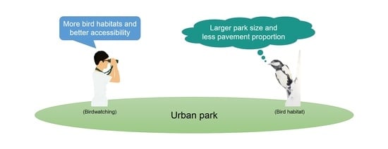
1. Introduction
2. Materials and Methods
2.1. Study Area
2.2. Data
2.2.1. Bird Census
2.2.2. Possible Influencing Factors: Park Characteristics and Land Cover
2.2.3. Birdwatching Record
2.3. Modeling Bird Habitats in Parks
2.4. Analyses
3. Results
3.1. Bird Census and Modeling
3.2. Spatial Patterns and Relationships of Park’s Bird Habitats and Birdwatching Records
3.3. Park Characteristics Explaining Variations in Bird Habitat Area and Birdwatching Activities
4. Discussion
4.1. Spatial Patterns of Parks with Bird Habitats and Birdwatching Record
4.2. Relationship between Parks with Bird Habitats and Birdwatching Record
4.3. Impacts of Park Characteristics on Bird Habitats and Birdwatching
4.4. Limitations
5. Conclusions
Supplementary Materials
Author Contributions
Funding
Acknowledgments
Conflicts of Interest
References
- Goddard, M.A.; Dougill, A.J.; Benton, T.G. Scaling up from gardens: Biodiversity conservation in urban environments. Trends Ecol. Evol. 2010, 25, 90–98. [Google Scholar] [CrossRef]
- Fuller, R.A.; Irvine, K.N.; Devine-Wright, P.; Warren, P.H.; Gaston, K.J. Psychological benefits of greenspace increase with biodiversity. Biol. Lett. 2007, 3, 390–394. [Google Scholar] [CrossRef] [PubMed]
- Ratcliffe, E.; Gatersleben, B.; Sowden, P.T. Bird sounds and their contributions to perceived attention restoration and stress recovery. J. Environ. Psychol. 2013, 36, 221–228. [Google Scholar] [CrossRef]
- Brock, M.; Perino, G.; Sugden, R. The Warden Attitude: An Investigation of the Value of Interaction with Everyday Wildlife. Environ. Resour. Econ. 2017, 67, 127–155. [Google Scholar] [CrossRef]
- Clucas, B.; Rabotyagov, S.; Marzluff, J.M. How much is that birdie in my backyard? A cross-continental economic valuation of native urban songbirds. Urban Ecosyst. 2015, 18, 251–266. [Google Scholar] [CrossRef]
- Hedblom, M.; Heyman, E.; Antonsson, H.; Gunnarsson, B. Bird song diversity influences young people’s appreciation of urban landscapes. Urban For. Urban Green. 2014, 13, 469–474. [Google Scholar] [CrossRef]
- Hedblom, M.; Knez, I.; Gunnarsson, B. Bird Diversity Improves the Well-Being of City Residents. In Ecology and Conservation of Birds in Urban Environments; Springer: Cham, Switzerland, 2017; pp. 287–306. [Google Scholar] [CrossRef]
- Jokimaki, J.; Suhonen, J. Distribution and habitat selection of wintering birds in urban environments. Landsc. Urban Plan. 1998, 39, 253–263. [Google Scholar] [CrossRef]
- Fernández-Juricic, E.; Poston, R.; De Collibus, K.; Morgan, T.; Bastain, B.; Martin, C.; Jones, K.; Treminio, R. Microhabitat selection and singing behavior patterns of male house finches (Carpodacus mexicanus) in urban parks in a heavily urbanized landscape in the Western US. Urban Habitats 2005, 3, 49–69. [Google Scholar]
- Chen, S.; Ding, P.; Zheng, G.; Wang, Y. Bird community patterns in response to the island features of urban woodlots in eastern China. Front. Biol. China 2006, 1, 448–454. [Google Scholar] [CrossRef]
- Fernandez-Juricic, E.; Jokimäki, J. A habitat island approach to conserving birds in urban landscapes: Case studies from southern and northern Europe. Biodivers. Conserv. 2001, 10, 2023–2043. [Google Scholar] [CrossRef]
- Seewagen, C.L.; Slayton, E.J. Mass Changes Of Migratory Landbirds During Stopovers in A New York City Park. Wilson J. Ornithol. 2008, 120, 296–303. [Google Scholar] [CrossRef]
- Cabrera-Cruz, S.A.; Cohen, E.B.; Smolinsky, J.A.; Buler, J.J. Artificial Light at Night is Related to Broad-Scale Stopover Distributions of Nocturnally Migrating Landbirds along the Yucatan Peninsula, Mexico. Remote Sens. 2020, 12, 395. [Google Scholar] [CrossRef]
- Kellert, S.R.; Brown, P.J. Human dimensions information in wildlife management, policy, and planning: Introductory comments to the special issue on human dimensions in wildlife management. Leis. Sci. Interdiscip. J. 1985, 7, 269–280. [Google Scholar] [CrossRef]
- Vas, K. Birding blogs as indicators of birdwatcher characteristics and trip preferences: Implications for birding destination planning and development. J. Destin. Mark. Manag. 2017, 6, 33–45. [Google Scholar] [CrossRef]
- Morelli, F.; Benedetti, Y.; Su, T.; Zhou, B.; Moravec, D.; Šímová, P.; Liang, W. Taxonomic diversity, functional diversity and evolutionary uniqueness in bird communities of Beijing’s urban parks: Effects of land use and vegetation structure. Urban For. Urban Green. 2017, 23, 84–92. [Google Scholar] [CrossRef]
- Graves, R.A.; Pearson, S.M.; Turner, M.G. Effects of bird community dynamics on the seasonal distribution of cultural ecosystem services. Ambio 2018, 48, 280–292. [Google Scholar] [CrossRef]
- Ma, Z.; Cheng, Y.; Wang, J.; Fu, X. The rapid development of birdwatching in mainland China: A new force for bird study and conservation. Bird Conserv. Int. 2012, 23, 259–269. [Google Scholar] [CrossRef]
- McGarigal, K. FRAGSTATS Help. Documentation for FRAGSTATS 4; University of Massachusetts: Amherst, MA, USA, 2015. [Google Scholar]
- Fernández-Juricic, E. Spatial and temporal analysis of the distribution of forest specialists in an urban-fragmented landscape (Madrid, Spain). Landsc. Urban Plan. 2004, 69, 17–32. [Google Scholar] [CrossRef]
- Huang, Y.; Zhao, Y.; Li, S.; von Gadow, K. The Effects of habitat area, vegetation structure and insect richness on breeding bird populations in Beijing urban parks. Urban For. Urban Green. 2015, 14, 1027–1039. [Google Scholar] [CrossRef]
- Xie, S.; Lu, F.; Cao, L.; Zhou, W.; Ouyang, Z. Multi-scale factors influencing the characteristics of avian communities in urban parks across Beijing during the breeding season. Sci. Rep. 2016, 6, 29350. [Google Scholar] [CrossRef]
- Schutz, C.; Schulze, C.H. Functional diversity of urban bird communities: Effects of landscape composition, green space area and vegetation cover. Ecol. Evol. 2015, 5, 5230–5239. [Google Scholar] [CrossRef] [PubMed]
- Fernández-Juricic, E. Bird community composition patterns in urban parks of Madrid_the role of age, size and isolation 2000. Ecol. Res. 2000, 15, 373–383. [Google Scholar] [CrossRef]
- Zhou, W.; Pickett, S.T.A.; Cadenasso, M.L. Shifting concepts of urban spatial heterogeneity and their implications for sustainability. Landsc. Ecol. 2016, 32, 15–30. [Google Scholar] [CrossRef]
- Stagoll, K.; Manning, A.D.; Knight, E.; Fischer, J.; Lindenmayer, D.B. Using bird–habitat relationships to inform urban planning. Landsc. Urban Plan. 2010, 98, 13–25. [Google Scholar] [CrossRef]
- Grafius, D.R.; Corstanje, R.; Siriwardena, G.M.; Plummer, K.E.; Harris, J.A. A bird’s eye view: Using circuit theory to study urban landscape connectivity for birds. Landsc. Ecol. 2017, 32, 1771–1787. [Google Scholar] [CrossRef]
- Amaya-Espinel, J.D.; Hostetler, M.; Henríquez, C.; Bonacic, C. The influence of building density on Neotropical bird communities found in small urban parks. Landsc. Urban Plan. 2019, 190, 103578. [Google Scholar] [CrossRef]
- Souza, F.L.; Valente-Neto, F.; Severo-Neto, F.; Bueno, B.; Ochoa-Quintero, J.M.; Laps, R.R.; Bolzan, F.; de Oliveira Roque, F. Impervious surface and heterogeneity are opposite drivers to maintain bird richness in a Cerrado city. Landsc. Urban Plan. 2019, 192, 103643. [Google Scholar] [CrossRef]
- Marzluff, J.M.; Bowman, R.; Donnelly, R. (Eds.) Avian Ecology and Conservation in an Urbanizing World; Springer Science & Business Media: New York, NY, USA, 2001. [Google Scholar]
- Zhou, D.; Chu, L.M. How would size, age, human disturbance, and vegetation structure affect bird communities of urban parks in different seasons? J. Ornithol. 2012, 153, 1101–1112. [Google Scholar] [CrossRef]
- Davis, A.Y.; Belaire, A.; Fafran, M.A.; Milz, D.; Sweeney, E.R.; Loss, S.R.; Minor, E.S. Green infrastructure and bird diversity across an urban socioeconomic gradient. Ecosphere 2012, 3, 105. [Google Scholar] [CrossRef]
- Le Louarn, M.; Clergeau, P.; Strubbe, D.; Deschamps-Cottin, M. Dynamic species distribution models reveal spatiotemporal habitat shifts in native range-expanding versus non-native invasive birds in an urban area. J. Avian Biol. 2018, 49, e01527. [Google Scholar] [CrossRef]
- Sushinsky, J.R.; Rhodes, J.R.; Possingham, H.P.; Gill, T.K.; Fuller, R.A. How should we grow cities to minimize their biodiversity impacts? Glob. Chang. Biol. 2013, 19, 401–410. [Google Scholar] [CrossRef] [PubMed]
- Booth, J.E.; Gaston, K.J.; Evans, K.L.; Armsworth, P.R. The value of species rarity in biodiversity recreation: A birdwatching example. Biol. Conserv. 2011, 144, 2728–2732. [Google Scholar] [CrossRef]
- Cumming, G.S.; Maciejewski, K. Reconciling community ecology and ecosystem services: Cultural services and benefits from birds in South African National Parks. Ecosyst. Serv. 2017, 28, 219–227. [Google Scholar] [CrossRef]
- Kuang, W.; Dou, Y. Investigating the Patterns and Dynamics of Urban Green Space in China’s 70 Major Cities Using Satellite Remote Sensing. Remote Sens. 2020, 12, 1929. [Google Scholar] [CrossRef]
- Baker, F.; Smith, C.; Cavan, G. A Combined Approach to Classifying Land Surface Cover of Urban Domestic Gardens Using Citizen Science Data and High Resolution Image Analysis. Remote Sens. 2018, 10, 537. [Google Scholar] [CrossRef]
- Fisher, J.R.B.; Acosta, E.A.; Dennedy-Frank, P.J.; Kroeger, T.; Boucher, T.M.; Pettorelli, N.; Buchanan, G. Impact of satellite imagery spatial resolution on land use classification accuracy and modeled water quality. Remote Sens. Ecol. Conserv. 2018, 4, 137–149. [Google Scholar] [CrossRef]
- Sobrino, J.A.; Irakulis, I. A Methodology for Comparing the Surface Urban Heat Island in Selected Urban Agglomerations Around the World from Sentinel-3 SLSTR Data. Remote Sens. 2020, 12, 2052. [Google Scholar] [CrossRef]
- Romaguera, M.; Vaughan, R.G.; Ettema, J.; Izquierdo-Verdiguier, E.; Hecker, C.A.; van der Meer, F.D. Detecting geothermal anomalies and evaluating LST geothermal component by combining thermal remote sensing time series and land surface model data. Remote Sens. Environ. 2018, 204, 534–552. [Google Scholar] [CrossRef]
- Wang, R.; Gao, W.; Peng, W. Downscale MODIS Land Surface Temperature Based on Three Different Models to Analyze Surface Urban Heat Island: A Case Study of Hangzhou. Remote Sens. 2020, 12, 2134. [Google Scholar] [CrossRef]
- Ermida, S.L.; Trigo, I.F.; DaCamara, C.C.; Roujean, J.-L. Assessing the potential of parametric models to correct directional effects on local to global remotely sensed LST. Remote Sens. Environ. 2018, 209, 410–422. [Google Scholar] [CrossRef]
- Heck, E.; de Beurs, K.M.; Owsley, B.C.; Henebry, G.M. Evaluation of the MODIS collections 5 and 6 for change analysis of vegetation and land surface temperature dynamics in North and South America. ISPRS J. Photogramm. Remote Sens. 2019, 156, 121–134. [Google Scholar] [CrossRef]
- Bleyhl, B.; Baumann, M.; Griffiths, P.; Heidelberg, A.; Manvelyan, K.; Radeloff, V.C.; Zazanashvili, N.; Kuemmerle, T. Assessing landscape connectivity for large mammals in the Caucasus using Landsat 8 seasonal image composites. Remote Sens. Environ. 2017, 193, 193–203. [Google Scholar] [CrossRef]
- Richter, R.; Heim, A.; Heim, W.; Kamp, J.; Vohland, M. Combining Multiband Remote Sensing and Hierarchical Distance Sampling to Establish Drivers of Bird Abundance. Remote Sens. 2019, 12, 38. [Google Scholar] [CrossRef]
- Cai, D.; Fraedrich, K.; Guan, Y.; Guo, S.; Zhang, C.; Carvalho, L.M.V.; Zhu, X. Causality of Biodiversity Loss: Climate, Vegetation, and Urbanization in China and America. Sensors 2019, 19, 4499. [Google Scholar] [CrossRef]
- Jacob, A.L.; Bonnell, T.R.; Dowhaniuk, N.; Hartter, J. Topographic and spectral data resolve land cover misclassification to distinguish and monitor wetlands in western Uganda. ISPRS J. Photogramm. Remote Sens. 2014, 94, 114–126. [Google Scholar] [CrossRef]
- Zielewska-Büttner, K.; Heurich, M.; Müller, J.; Braunisch, V. Remotely Sensed Single Tree Data Enable the Determination of Habitat Thresholds for the Three-Toed Woodpecker (Picoides tridactylus). Remote Sens. 2018, 10, 1972. [Google Scholar] [CrossRef]
- Bonthoux, S.; Lefèvre, S.; Herrault, P.-A.; Sheeren, D. Spatial and Temporal Dependency of NDVI Satellite Imagery in Predicting Bird Diversity over France. Remote Sens. 2018, 10, 1136. [Google Scholar] [CrossRef]
- Remelgado, R.; Leutner, B.; Safi, K.; Sonnenschein, R.; Kuebert, C.; Wegmann, M.; Pettorelli, N.; Ryan, S. Linking animal movement and remote sensing-mapping resource suitability from a remote sensing perspective. Remote Sens. Ecol. Conserv. 2018, 4, 211–224. [Google Scholar] [CrossRef]
- Wicaksono, P.; Aryaguna, P.A.; Lazuardi, W. Benthic Habitat Mapping Model and Cross Validation Using Machine-Learning Classification Algorithms. Remote Sens. 2019, 11, 1279. [Google Scholar] [CrossRef]
- Pettorelli, N.; Schulte to Bühne, H.; Tulloch, A.; Dubois, G.; Macinnis-Ng, C.; Queirós, A.M.; Keith, D.A.; Wegmann, M.; Schrodt, F.; Stellmes, M.; et al. Satellite remote sensing of ecosystem functions: Opportunities, challenges and way forward. Remote Sens. Ecol. Conserv. 2018, 4, 71–93. [Google Scholar] [CrossRef]
- Pilant, A.; Endres, K.; Rosenbaum, D.; Gundersen, G. US EPA EnviroAtlas Meter-Scale Urban Land Cover (MULC): 1-m Pixel Land Cover Class Definitions and Guidance. Remote Sens. 2020, 12, 1909. [Google Scholar] [CrossRef] [PubMed]
- Morris, K.M.; Soehren, E.C.; Woodrey, M.S.; Rush, S.A. Habitat-Suitability Model for the Yellow Rail (Coturnicops noveboracensis) in the Northern Gulf Coast of Alabama and Mississippi, USA. Remote Sens. 2020, 12, 848. [Google Scholar] [CrossRef]
- Merow, C.; Smith, M.J.; Silander, J.A. A practical guide to MaxEnt for modeling species’ distributions: What it does, and why inputs and settings matter. Ecography 2013, 36, 1058–1069. [Google Scholar] [CrossRef]
- Phillips, S.J.; Anderson, R.P.; Schapire, R.E. Maximum entropy modeling of species geographic distributions. Ecol. Model. 2006, 190, 231–259. [Google Scholar] [CrossRef]
- Gallardo, B.; zu Ermgassen, P.S.E.; Aldridge, D.C.; Veech, J. Invasion ratcheting in the zebra mussel (Dreissena polymorpha) and the ability of native and invaded ranges to predict its global distribution. J. Biogeogr. 2013, 40, 2274–2284. [Google Scholar] [CrossRef]
- Evangelista, P.; Stohlgren, T.; Morisette, J.; Kumar, S. Mapping Invasive Tamarisk (Tamarix): A Comparison of Single-Scene and Time-Series Analyses of Remotely Sensed Data. Remote Sens. 2009, 1, 519–533. [Google Scholar] [CrossRef]
- Liu, X.; Liu, H.; Gong, H.; Lin, Z.; Lv, S. Appling the One-Class Classification Method of Maxent to Detect an Invasive Plant Spartina alterniflora with Time-Series Analysis. Remote Sens. 2017, 9, 1120. [Google Scholar] [CrossRef]
- Qian, Y.; Zhou, W.; Yu, W.; Pickett, S.T.A. Quantifying spatiotemporal pattern of urban greenspace: New insights from high resolution data. Landsc. Ecol. 2015, 30, 1165–1173. [Google Scholar] [CrossRef]
- Bureau of Statistics of Beijing. Changes and Characteristics of Beijing’s Population Development in 2014. Available online: http://tjj.beijing.gov.cn/zxfbu/202002/t20200216_1636952.html (accessed on 22 May 2015).
- Beijing Municipal Administration Center of the Parks. The Report of Beijing Municipal Administration Center on the 2010 Work Summary and the 2011 Work Plan. Available online: http://report.bjmacp.gov.cn/xxgkxx.ASPX?newsid=112677 (accessed on 1 December 2016).
- Beijing Gardening and Greening Bureau. The Urban Parks of Beijing. Available online: http://yllhj.beijing.gov.cn/ggfw/gyfjqyl/cs/ (accessed on 1 January 2018).
- Beijing Municipal Administration of Culture and Tourism. Statistical Table of Maximum Carrying Capacity of A-Level Tourist Scenic in Beijing. Available online: http://whlyj.beijing.gov.cn/zwgk/tzgg/201809/P020200407399785305222.doc (accessed on 1 December 2018).
- The Report of Beijing Municipal Administration Center of Parks on the 2017 Work Summary and the 2018 Work Plan. Available online: http://gygl.beijing.gov.cn/xxgk/xxgk_ghjh/201912/t20191218_1269293.html (accessed on 23 March 2018).
- Bird Watch China Society. The Checklist of Birds of Beijing (2014 Edition); Bird Watch China Society: Beijing, China, 2014. [Google Scholar]
- IUCN. IUCN Endangered Species Redlist. 2016. Available online: http://www.iucnredlist.org (accessed on 9 November 2015).
- Cheng, Y.X.; Wang, J.Y.; He, X.; Ma, Z.J. Present status and development of birdwatching in mainland China. J. East China Norm. Univ. 2013, 2, 63. [Google Scholar]
- Walther, B.A.; White, A. The emergence of birdwatching in China: History, demographics, activities, motivations, and environmental concerns of Chinese birdwatchers. Bird Conserv. Int. 2018, 28, 1–13. [Google Scholar] [CrossRef]
- Bird Watch China Society. The Topic of Birdwatching in Urban Green Island. Available online: http://bbs.cbw.org.cn/forum.php?mod=forumdisplay&fid=26 (accessed on 30 June 2018).
- Friends of Nature Wild Bird Society. Bird Survey 20 Years: Friends of Nature Wild Bird Society Publish Bird Survey Results at Beijing. Available online: http://www.sohu.com/a/116242097_403458 (accessed on 15 October 2016).
- Fuller, R.J.; Langslow, D.R. Estimating numbers of birds by point counts: How long should counts last? Bird Study 1984, 31, 195–202. [Google Scholar] [CrossRef]
- Tu, X.; Huang, G.; Wu, J. Contrary to common observations in the west, urban park access is only weakly related to neighborhood socioeconomic conditions in Beijing, China. Sustainability 2018, 10, 1115. [Google Scholar] [CrossRef]
- China Birdwatching Record Center. Available online: http://www.szbird.org.cn/birdtalker.net/index.asp (accessed on 24 September 2020).
- Cai, Q. Birds of Beijing; Beijing Publishing House: Beijing, China, 1988. [Google Scholar]
- Zhao, Z.J. The Hand Book of Birds of China; Jilin Science and Technology Press House: Changchun, China, 2001. [Google Scholar]
- Gower, J.C. A General Coefficient of Similarity and Some of Its Properties. Biometrics 1971, 4, 857–891. [Google Scholar] [CrossRef]
- Swenson, N.G. Functional And Phylogenetic Ecology in R; Springer Science+Business Media: New York, NY, USA, 2014; pp. 68–70. [Google Scholar] [CrossRef]
- Elith, J.; Leathwick, J. Predicting species distributions from museum and herbarium records using multiresponse models fitted with multivariate adaptive regression splines. Divers. Distrib. 2007, 13, 265–275. [Google Scholar] [CrossRef]
- Dallimer, M.; Irvine, K.N.; Skinner, A.M.J.; Davies, Z.G.; Rouquette, J.R.; Maltby, L.L.; Warren, P.H.; Armsworth, P.R.; Gaston, K.J. Biodiversity and the Feel-Good Factor: Understanding Associations between Self-Reported Human Well-being and Species Richness. BioScience 2012, 62, 47–55. [Google Scholar] [CrossRef]
- Schipperijn, J.; Stigsdotter, U.K.; Randrup, T.B.; Troelsen, J. Influences on the use of urban green space—A case study in Odense, Denmark. Urban For. Urban Green. 2010, 9, 25–32. [Google Scholar] [CrossRef]
- Carrasco, L.; Giam, X.; Papeş, M.; Sheldon, K. Metrics of Lidar-Derived 3D Vegetation Structure Reveal Contrasting Effects of Horizontal and Vertical Forest Heterogeneity on Bird Species Richness. Remote Sens. 2019, 11, 743. [Google Scholar] [CrossRef]


| Variable | Explanation | Data Source |
|---|---|---|
| Bird distribution map | Presence–absence dataset for each breeding guild | Bird census survey |
| Land cover type | Woodland, grassland, waterbody, pavements, building, road, bare land | Landsat ETM+ image, 2016 |
| Normalized difference vegetation index (NDVI) | R: reflectance value at the red band | Landsat ETM+ image, 2016 |
| Slope | Develop from Digital Elevation Model (DEM 30) through 3D analysis | DEM 30, 2011 |
| Distance to city center | Direct distance from the site to city center | Landsat ETM+ image, 2016 |
| Distance to waterbody | Direct distance to the nearest waterbody | Landsat ETM+ image, 2016 |
| Independent Variable | Dependent Variable | |||
|---|---|---|---|---|
| Area of Bird Habitat (n = 61) | Number of Birdwatching Records (n = 26) | |||
| Standardized Coefficient | Significance | Standardized Coefficient | Significance | |
| Park size | 1.011 | <0.001 | 1.756 | <0.001 |
| Park age | 0.292 | <0.001 | —— | —— |
| PLAND_pavements | −0.613 | <0.001 | —— | —— |
| CONNECT | 0.143 | 0.023 | —— | —— |
| LPI_pavements | 0.228 | 0.002 | —— | —— |
| PD_woodland | 0.230 | 0.003 | —— | —— |
| LSI_woodland | —— | —— | −1.085 | 0.002 |
| Area of bird habitat | —— | —— | 0.820 | <0.001 |
| Category | Indicators with Significant Differences (p < 0.05) | Mean Value with Birdwatching (n = 26) 1 | Mean Value Without Bird Watching (n = 76) 1 |
|---|---|---|---|
| Basic indicator | Park size | 86.37 | 24.87 |
| Park age | 48.73 | 19.00 | |
| Urbanization | Distance to city center | 6825.18 | 8889.76 |
| Accessibility | Number of bus stop | 42.96 | 26.28 |
| Number of subway station | 1.56 | 0.79 | |
| neighbor road density | 63.51 | 45.19 | |
| Landscape composition and configuration | PLAND_woodland | 56.05 | 70.50 |
| PLAND_pavements | 6.73 | 9.21 | |
| PD_woodland | 156.85 | 239.89 | |
| ED_waterbody | —— | —— |
© 2020 by the authors. Licensee MDPI, Basel, Switzerland. This article is an open access article distributed under the terms and conditions of the Creative Commons Attribution (CC BY) license (http://creativecommons.org/licenses/by/4.0/).
Share and Cite
Zhang, Z.; Huang, G. How Do Urban Parks Provide Bird Habitats and Birdwatching Service? Evidence from Beijing, China. Remote Sens. 2020, 12, 3166. https://doi.org/10.3390/rs12193166
Zhang Z, Huang G. How Do Urban Parks Provide Bird Habitats and Birdwatching Service? Evidence from Beijing, China. Remote Sensing. 2020; 12(19):3166. https://doi.org/10.3390/rs12193166
Chicago/Turabian StyleZhang, Zhengkai, and Ganlin Huang. 2020. "How Do Urban Parks Provide Bird Habitats and Birdwatching Service? Evidence from Beijing, China" Remote Sensing 12, no. 19: 3166. https://doi.org/10.3390/rs12193166
APA StyleZhang, Z., & Huang, G. (2020). How Do Urban Parks Provide Bird Habitats and Birdwatching Service? Evidence from Beijing, China. Remote Sensing, 12(19), 3166. https://doi.org/10.3390/rs12193166