Atmospheric Correction of GOCI Using Quasi-Synchronous VIIRS Data in Highly Turbid Coastal Waters
Abstract
1. Introduction
2. Study Sites
3. Method
3.1. Previous AC Algorithms
3.2. The Development of the New AC Algorithm
- Extracting the ρa(NIRV) of VIIRS;
- Estimating the aerosol properties by ρa(NIRV);
- Calculating the ρa(λG) at GOCI observing geometries according to the aerosol properties; and
- Removing the ρa(λG) and completing the GOCI AC process.
4. Results and Discussion
5. Conclusions
Author Contributions
Funding
Acknowledgments
Conflicts of Interest
References
- Wang, M.H. A sensitivity study of the SeaWiFS atmospheric correction algorithm: Effects of spectral band variations. Remote Sens. Environ. 1999, 67, 348–359. [Google Scholar] [CrossRef]
- Wang, M.H. A refinement for the Rayleigh radiance computation with variation of the atmospheric pressure. Int. J. Remote Sens. 2005, 26, 5651–5663. [Google Scholar] [CrossRef]
- Wang, M.H. Rayleigh radiance computations for satellite remote sensing: Accounting for the effect of sensor spectral response function. Opt. Express 2016, 24, 2414–2429. [Google Scholar] [CrossRef] [PubMed]
- Gordon, H.R.; Wang, M. Retrieval of water-leaving radiance and aerosol optical thickness over the oceans with SeaWiFS: A preliminary algorithm. Appl. Opt. 1994, 33, 443–452. [Google Scholar] [CrossRef] [PubMed]
- Emberton, S.; Chittka, L.; Cavallaro, A.; Wang, M.H. Sensor Capability and Atmospheric Correction in Ocean Colour Remote Sensing. Remote Sens. 2016, 8, 1. [Google Scholar] [CrossRef]
- Ryu, J.H.; Han, H.J.; Cho, S.; Park, Y.J.; Ahn, Y.H. Overview of Geostationary Ocean Color Imager (GOCI) and GOCI Data Processing System (GDPS). Ocean Sci. J. 2012, 47, 223–233. [Google Scholar] [CrossRef]
- Hu, Z.F.; Pan, D.L.; He, X.Q.; Bai, Y. Diurnal Variability of Turbidity Fronts Observed by Geostationary Satellite Ocean Color Remote Sensing. Remote Sens. 2016, 8, 147. [Google Scholar] [CrossRef]
- Choi, J.K.; Min, J.E.; Noh, J.H.; Han, T.H.; Yoon, S.; Park, Y.J.; Moon, J.E.; Ahn, J.H.; Ahn, S.M.; Park, J.H. Harmful algal bloom (HAB) in the East Sea identified by the Geostationary Ocean Color Imager (GOCI). Harmful Algae 2014, 39, 295–302. [Google Scholar] [CrossRef]
- Liu, R.J.; Zhang, J.; Yao, H.Y.; Cui, T.W.; Wang, N.; Zhang, Y.; Wu, L.J.; An, J.B. Hourly changes in sea surface salinity in coastal waters recorded by Geostationary Ocean Color Imager. Estuar Coast Shelf Sci. 2017, 196, 227–236. [Google Scholar] [CrossRef]
- Choi, J.K.; Park, Y.J.; Ahn, J.H.; Lim, H.S.; Eom, J.; Ryu, J.H. GOCI, the world’s first geostationary ocean color observation satellite, for the monitoring of temporal variability in coastal water turbidity. J. Geophys. Res. Ocean. 2012, 117. [Google Scholar] [CrossRef]
- Vanhellemont, Q.; Ruddick, K. Advantages of high quality SWIR bands for ocean colour processing: Examples from Landsat-8. Remote Sens. Environ. 2015, 161, 89–106. [Google Scholar] [CrossRef]
- He, Q.J.; Chen, C.Q. A new approach for atmospheric correction of MODIS imagery in turbid coastal waters: A case study for the Pearl River Estuary. Remote Sens. Lett. 2014, 5, 249–257. [Google Scholar] [CrossRef]
- Wang, M.H.; Shi, W. Estimation of ocean contribution at the MODIS near-infrared wavelengths along the east coast of the US: Two case studies. Geophys. Res. Lett. 2005, 32. [Google Scholar] [CrossRef]
- Wang, M.H.; Shi, W. The NIR-SWIR combined atmospheric correction approach for MODIS ocean color data processing. Opt. Express 2007, 15, 15722–15733. [Google Scholar] [CrossRef] [PubMed]
- Jiang, L.D.; Wang, M.H. Improved near-infrared ocean reflectance correction algorithm for satellite ocean color data processing. Opt. Express 2014, 22, 21657–21678. [Google Scholar] [CrossRef]
- Cao, C.Y.; de Luccia, F.J.; Xiong, X.X.; Wolfe, R.; Weng, F.Z. Early On-Orbit Performance of the Visible Infrared Imaging Radiometer Suite Onboard the Suomi National Polar-Orbiting Partnership (S-NPP) Satellite. IEEE Trans. Geosci. Remote 2014, 52, 1142–1156. [Google Scholar] [CrossRef]
- Shi, W.; Zhang, Y.L.; Wang, M.H. Deriving Total Suspended Matter Concentration from the Near-Infrared-Based Inherent Optical Properties over Turbid Waters: A Case Study in Lake Taihu. Remote Sens. 2018, 10, 333. [Google Scholar] [CrossRef]
- Cao, C.Y.; Xiong, J.; Blonski, S.; Liu, Q.H.; Uprety, S.; Shao, X.; Bai, Y.; Weng, F.Z. Suomi NPP VIIRS sensor data record verification, validation, and long-term performance monitoring. J. Geophys. Res. Atmos. 2013, 118, 11664–11678. [Google Scholar] [CrossRef]
- Wang, M.H.; Son, S. VIIRS-derived chlorophyll-a using the ocean color index method. Remote Sens. Environ. 2016, 182, 141–149. [Google Scholar] [CrossRef]
- Bian, C.W.; Jiang, W.S.; Pohlmann, T.; Sundermann, J. Hydrography-Physical Description of the Bohai Sea. J. Coast. Res. 2016, 74, 1–12. [Google Scholar] [CrossRef]
- Wang, H.J.; Wang, A.M.; Bi, N.H.; Zeng, X.M.; Xiao, H.H. Seasonal distribution of suspended sediment in the Bohai Sea, China. Cont. Shelf Res. 2014, 90, 17–32. [Google Scholar] [CrossRef]
- Milliman, J.D.; Li, F.; Zhao, Y.Y.; Zheng, T.M.; Limeburner, R. Suspended Matter Regime in the Yellow Sea. Prog. Oceanogr. 1986, 17, 215–227. [Google Scholar] [CrossRef]
- Min, J.E.; Choi, J.K.; Yang, H.; Lee, S.; Ryu, J.H. Monitoring changes in suspended sediment concentration on the southwestern coast of Korea. J. Coast. Res. 2014, 133–138. [Google Scholar] [CrossRef]
- Dong, L.X.; Guan, W.B.; Chen, Q.; Li, X.H.; Liu, X.H.; Zeng, X.M. Sediment transport in the Yellow Sea and East China Sea. Estuar. Coast. Shelf Sci. 2011, 93, 248–258. [Google Scholar] [CrossRef]
- Wang, Y.; Shen, J.; He, Q.; Zhu, L.; Zhang, D. Seasonal variations of transport time of freshwater exchanges between Changjiang Estuary and its adjacent regions. Estuar. Coast. Shelf Sci. 2015, 157, 109–119. [Google Scholar] [CrossRef]
- Su, J.L.; Wang, K.S. Changjiang River Plume and Suspended Sediment Transport in Hangzhou Bay. Cont. Shelf Res. 1989, 9, 93–111. [Google Scholar]
- Saito, Y.; Yang, Z.S. Historical change of the Huanghe (Yellow River) and its impact on the sediment budget of the East China Sea. In Global Fluxs of Carbon and Its Related Substances in the Coastal Sea-Ocean Atmosphere System; M & J International: Yokohama, Japan, 1995. [Google Scholar]
- Bian, C.W.; Jiang, W.S.; Quan, Q.; Wang, T.; Greatbatch, R.J.; Li, W. Distributions of suspended sediment concentration in the Yellow Sea and the East China Sea based on field surveys during the four seasons of 2011. J. Mar. Syst. 2013, 121, 24–35. [Google Scholar] [CrossRef]
- Bian, C.W.; Jiang, W.S.; Greatbatch, R.J. An exploratory model study of sediment transport sources and deposits in the Bohai Sea, Yellow Sea, and East China Sea. J. Geophys. Res. Ocean. 2013, 118, 5908–5923. [Google Scholar] [CrossRef]
- Thuillier, G.; Herse, M.; Simon, P.C.; Labs, D.; Mandel, H.; Gillotay, D.; Foujols, T. The visible solar spectral irradiance from 350 to 850 nm as measured by the SOLSPEC spectrometer during the ATLAS I mission. Sol. Phys. 1998, 177, 41–61. [Google Scholar] [CrossRef]
- Gordon, H.R.; Wang, M.H. Influence of Oceanic Whitecaps on Atmospheric Correction of Ocean-Color Sensors. Appl. Opt. 1994, 33, 7754–7763. [Google Scholar] [CrossRef]
- Wang, M.H.; Bailey, S.W. Correction of sun glint contamination on the SeaWiFS ocean and atmosphere products. Appl. Opt. 2001, 40, 4790–4798. [Google Scholar] [CrossRef]
- Bailey, S.W.; Franz, B.A.; Werdell, P.J. Estimation of near-infrared water-leaving reflectance for satellite ocean color data processing. Opt. Express 2010, 18, 7521–7527. [Google Scholar] [CrossRef] [PubMed]
- Ahn, J.H.; Park, Y.J.; Ryu, J.H.; Lee, B.; Oh, I.S. Development of Atmospheric Correction Algorithm for Geostationary Ocean Color Imager (GOCI). Ocean Sci. J. 2012, 47, 247–259. [Google Scholar] [CrossRef]
- Lee, B.; Ahn, J.H.; Park, Y.J.; Kim, S.W. Turbid water atmospheric correction for GOCI: Modification of MUMM algorithm. Korean J. Remote Sens. 2013, 29, 173–182. [Google Scholar] [CrossRef]
- Park, Y.J.; Ahn, Y.H.; Han, H.J.; Yang, H.; Moon, J.E.; Ahn, J.H.; Lee, B.R.; Min, J.E.; Lee, S.J.; Kim, K.S.; et al. GOCI Level 2 Ocean Color Products (GDPS 1.3) Brief Algorithm Description; Korea Ocean Satellite Center, Korea Institute of Ocean Science and Technology: Ansan, Korea, 2014. [Google Scholar]
- Ruddick, K.G.; Ovidio, F.; Rijkeboer, M. Atmospheric correction of SeaWiFS imagery for turbid coastal and inland waters. Appl. Opt. 2000, 39, 897–912. [Google Scholar] [CrossRef] [PubMed]
- Goyens, C.; Jamet, C.; Schroeder, T. Evaluation of four atmospheric correction algorithms for MODIS-Aqua images over contrasted coastal waters. Remote Sens. Environ. 2013, 131, 63–75. [Google Scholar] [CrossRef]
- Hu, C.M.; Carder, K.L.; Muller-Karger, F.E. Atmospheric correction of SeaWiFS imagery over turbid coastal waters: A practical method. Remote Sens. Environ. 2000, 74, 195–206. [Google Scholar] [CrossRef]
- Huang, X.C.; Zhu, J.H.; Han, B.; Jamet, C.; Tian, Z.; Zhao, Y.L.; Li, J.; Li, T.J. Evaluation of Four Atmospheric Correction Algorithms for GOCI Images over the Yellow Sea. Remote Sens. 2019, 11, 1631. [Google Scholar] [CrossRef]
- Goyens, C.; Jamet, C.; Ruddick, K.G. Spectral relationships for atmospheric correction. II. Improving NASA’s standard and MUMM near infra-red modeling schemes. Opt. Express 2013, 21, 21176–21187. [Google Scholar] [CrossRef]
- Goyens, C.; Jamet, C.; Ruddick, K.G. Spectral relationships for atmospheric correction. I. Validation of red and near infra-red marine reflectance relationships. Opt. Express 2013, 21, 21162–21175. [Google Scholar] [CrossRef]
- Doxaran, D.; Froidefond, J.M.; Lavender, S.; Castaing, P. Spectral signature of highly turbid waters—Application with SPOT data to quantify suspended particulate matter concentrations. Remote Sens. Environ. 2002, 81, 149–161. [Google Scholar] [CrossRef]
- Wang, M.H.; Son, S.; Shi, W. Evaluation of MODIS SWIR and NIR-SWIR atmospheric correction algorithms using SeaBASS data. Remote Sens. Environ. 2009, 113, 635–644. [Google Scholar] [CrossRef]
- Wang, M.H.; Shi, W. Sensor Noise Effects of the SWIR Bands on MODIS-Derived Ocean Color Products. IEEE Trans. Geosci. Remote 2012, 50, 3280–3292. [Google Scholar] [CrossRef]
- Carswell, T.; Costa, M.; Young, E.; Komick, N.; Gower, J.; Sweeting, R. Evaluation of MODIS-Aqua Atmospheric Correction and Chlorophyll Products of Western North American Coastal Waters Based on 13 Years of Data. Remote Sens. 2017, 9, 1063. [Google Scholar] [CrossRef]
- Ye, H.B.; Chen, C.Q.; Yang, C.Y. Atmospheric Correction of Landsat-8/OLI Imagery in Turbid Estuarine Waters: A Case Study for the Pearl River Estuary. IEEE J. STARS 2017, 10, 252–261. [Google Scholar] [CrossRef]
- Ahmad, Z.; Franz, B.A.; McClain, C.R.; Kwiatkowska, E.J.; Werdell, J.; Shettle, E.P.; Holben, B.N. New aerosol models for the retrieval of aerosol optical thickness and normalized water-leaving radiances from the SeaWiFS and MODIS sensors over coastal regions and open oceans. Appl. Opt. 2010, 49, 5545–5560. [Google Scholar] [CrossRef]
- Yang, H.Y.; Gordon, H.R. Remote sensing of ocean color: Assessment of water-leaving radiance bidirectional effects on atmospheric diffuse transmittance. Appl. Opt. 1997, 36, 7887–7897. [Google Scholar] [CrossRef]
- Masmoudi, M.; Chaabane, M.; Tanre, D.; Gouloup, P.; Blarel, L.; Elleuch, F. Spatial and temporal variability of aerosol: Size distribution and optical properties. Atmos. Res. 2003, 66, 1–19. [Google Scholar] [CrossRef]
- Queface, A.J.; Piketh, S.J.; Annegarn, H.J.; Holben, B.N.; Uthui, R.J. Retrieval of aerosol optical thickness and size distribution from the CIMEL Sun photometer over Inhaca Island, Mozambique. J. Geophys. Res. Atmos. 2003, 108. [Google Scholar] [CrossRef]
- Franz, B.A. rhoa_to_rhoas—MS aerosol reflectance to SS aerosol reflectance. In Aerosol.c in SeaDAS Code; NASA’s Ocean Biology Processing Group (OBPG), 2004. Available online: http://seadas.gsfc.nasa.gov (accessed on 8 January 2016).
- McCarthy, S.C.; Gould, R.W.; Richman, J.; Kearney, C.; Lawson, A. Impact of Aerosol Model Selection on Water-Leaving Radiance Retrievals from Satellite Ocean Color Imagery. Remote Sens. 2012, 4, 3638–3665. [Google Scholar] [CrossRef]
- Cho, S. Introduction of GOCI and GOCI-II Mission with Lunar Calibration. In Lunar Calibration Workshop; EUMETSAT: Darmstadt, Germany; Available online: http://gsics.atmos.umd.edu/pub/Development/ LunarCalibrationWorkshop/4b_Cho_GOCI2.pdf (accessed on 10 August 2018).
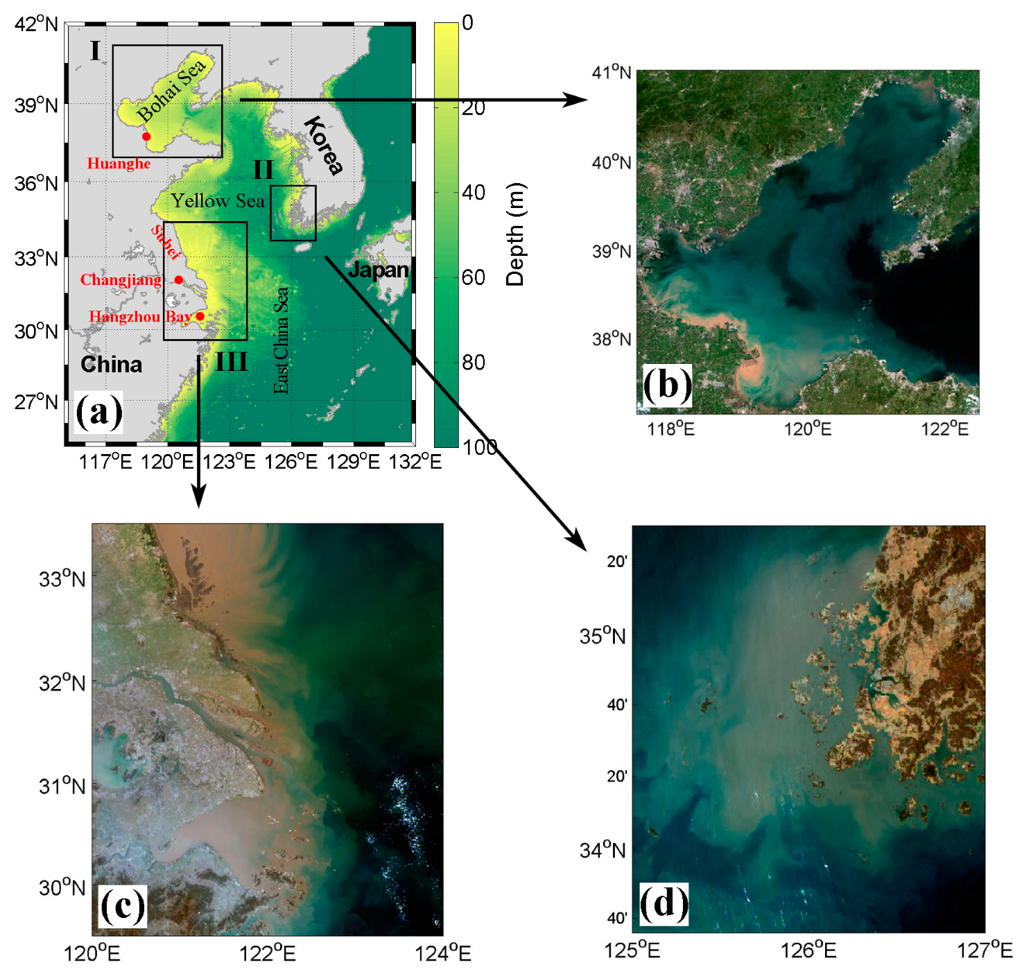
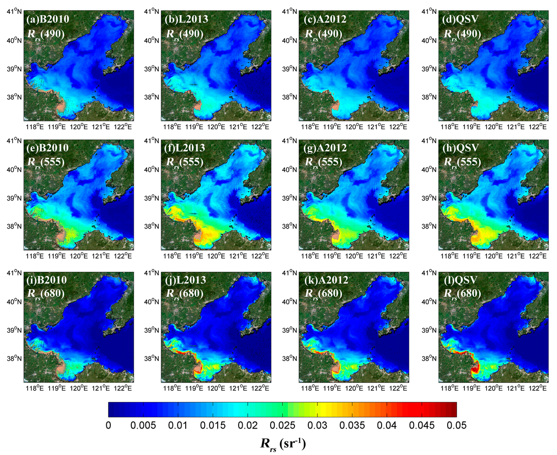
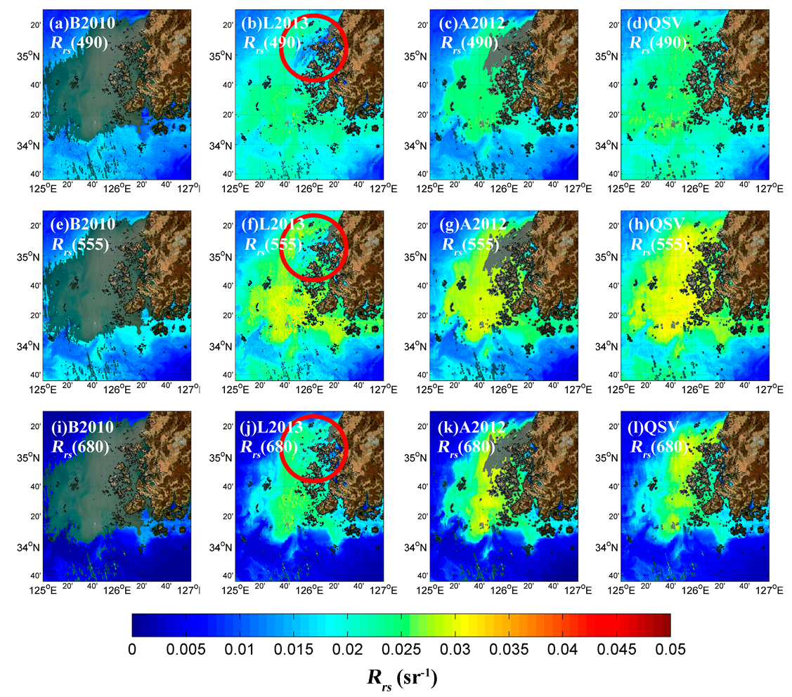
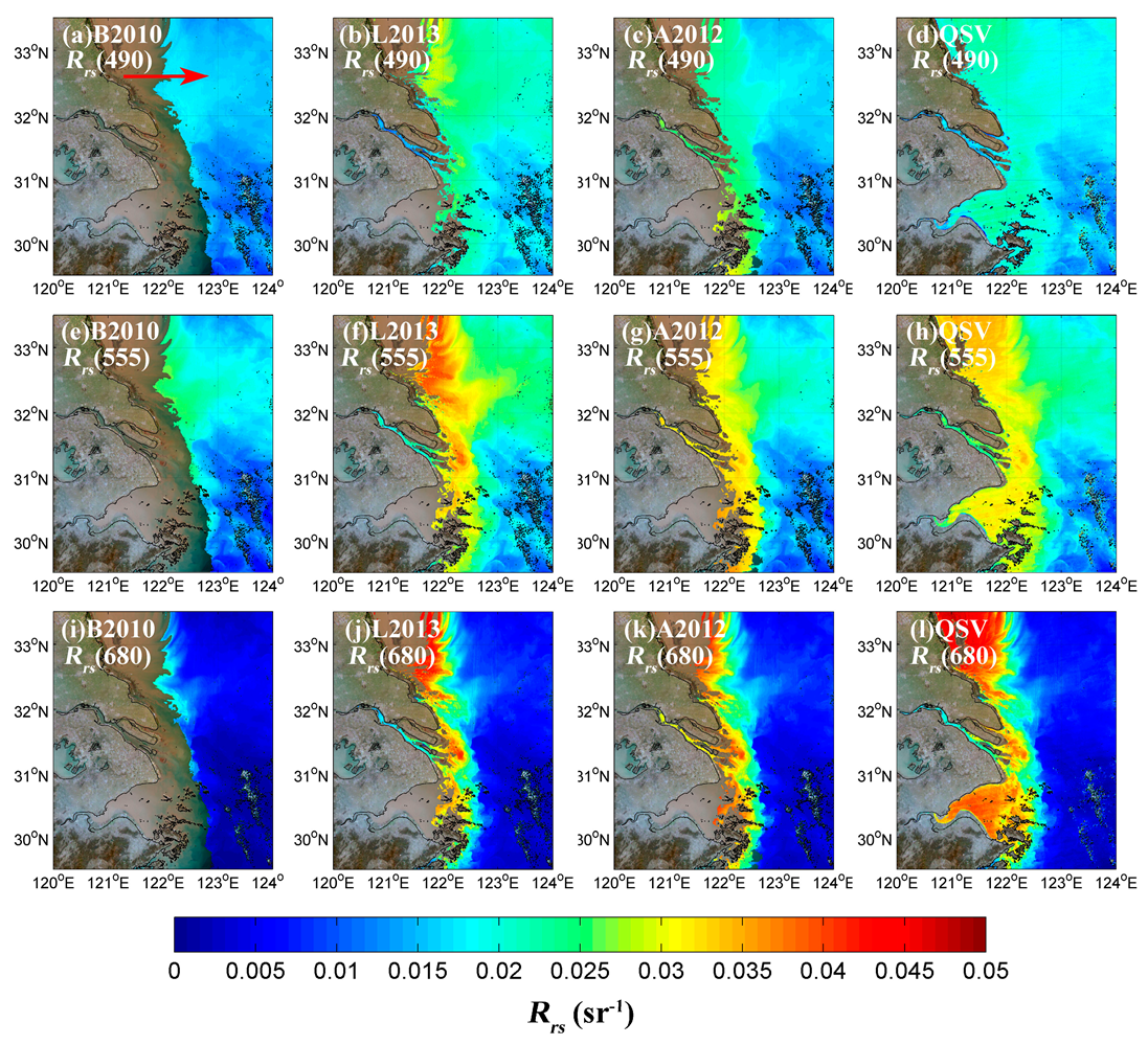

| Area | Location | Date (MM-DD-YY) | Time Lag (min) |
|---|---|---|---|
| I | Bohai Sea | 08-26-2016 | 9 |
| II | Southwest coast of Korea | 03-14-2017 | 21 |
| III | Changjiang Estuary | 03-01-2016 | 27 |
© 2019 by the authors. Licensee MDPI, Basel, Switzerland. This article is an open access article distributed under the terms and conditions of the Creative Commons Attribution (CC BY) license (http://creativecommons.org/licenses/by/4.0/).
Share and Cite
Wu, J.; Chen, C.; Nukapothula, S. Atmospheric Correction of GOCI Using Quasi-Synchronous VIIRS Data in Highly Turbid Coastal Waters. Remote Sens. 2020, 12, 89. https://doi.org/10.3390/rs12010089
Wu J, Chen C, Nukapothula S. Atmospheric Correction of GOCI Using Quasi-Synchronous VIIRS Data in Highly Turbid Coastal Waters. Remote Sensing. 2020; 12(1):89. https://doi.org/10.3390/rs12010089
Chicago/Turabian StyleWu, Jie, Chuqun Chen, and Sravanthi Nukapothula. 2020. "Atmospheric Correction of GOCI Using Quasi-Synchronous VIIRS Data in Highly Turbid Coastal Waters" Remote Sensing 12, no. 1: 89. https://doi.org/10.3390/rs12010089
APA StyleWu, J., Chen, C., & Nukapothula, S. (2020). Atmospheric Correction of GOCI Using Quasi-Synchronous VIIRS Data in Highly Turbid Coastal Waters. Remote Sensing, 12(1), 89. https://doi.org/10.3390/rs12010089


