Abstract
The three-leg 50-Years Roundabout at King Abdulaziz University (KAU) is known for its vibrance and important location as it is located at the center of several major buildings and hospitals. In recent years, the roundabout is witnessing a huge demand that influences the university road networks’ level of service, “LOS”, which in return, has negative impacts on students and faculties in terms of delay and travel time. Several treatments can be implemented along the roundabout. One of those treatments is applying restrictions during morning peak hours such as blocking and restricting specific lanes. This treatment has the advantage of reducing conflict points that cause sudden and frequent stops at the roundabout; as a result, delay and congestion occur. By reducing conflict points, traffic flow can be improved, in addition to enhancing safety and promoting sustainability. This paper examines the base condition of the 50-Years Roundabout in terms of traffic flow, LOS, delay, capacity, and toxic emissions, and proposes traffic system management (TSM) strategies through applying restricted and designated lanes to improve traffic condition. The study employs PTV Vissim, SIDRA Intersection, and Surrogate Safety Assessment Model “SSAM” to examine the base and proposed conditions. The results show a significant improvement through the reduction in conflict points, so that reflects the positive impacts on sustainability, congestion, delay, travel time, LOS, and overall toxic emissions.
Keywords:
capacity; circulating flow; delay; KAU; LOS; PTV Vissim; restricted lanes; roundabout; SIDRA Intersection; SSAM; emissions; sustainability 1. Introduction
Roundabouts have emerged as a widespread type of intersection control across the globe because they have proven safety and efficiency advantages. The modern roundabout, characterized by yield-at-entry control and geometric design elements that reduce the speed of entering traffic, was developed in the mid-20th century to rectify issues with the preceding traffic circles. Unlike large, traditional rotaries, modern roundabouts reduce conflict points and simplify traffic flow by yielding the right-of-way to traffic already in the circle and requiring entering traffic to yield []. These elements result in dramatically fewer severe collisions—studies demonstrate that roundabouts can reduce fatal crashes by about 90% compared to traditional signalized intersections []. As a result, their implementation has accelerated; for example, the United States built its first modern roundabout in 1990 and now boasts thousands of roundabouts (over 9000 as of the latest estimates) []. Roundabouts are also praised for improving operational performance by minimizing delays of vehicles as well as queues through continuous low-speed flow []. These advantages have rendered roundabouts an attractive alternative for improving safety and level of service (LOS) at intersections [].
However, the operation of multi-lane roundabouts under high traffic demand levels remains an issue. Under peak conditions, high demand and unfavorable driver behavior (e.g., hesitation in lane selection or failure to yield appropriately) may cause conflict points, congestion, and delay to increase []. That is, the same conditions roundabouts manage at medium traffic volume overburden roundabouts at high demand, leading to ineffective or even unsafe functioning of the intersection []. Previous studies have said that the capacity of traditional roundabouts may not be adequate for heavy traffic flow []. Additionally, complex designs may puzzle drivers; for instance, inappropriate responses and mixing up lane regulations in multi-lane roundabouts have been documented to heighten collision risks []. These are issues that have motivated transportation engineers to pursue improvement for roundabout performance under congested conditions.
Physical redesign is one method of enhancing roundabout performance. One example is the turbo roundabout, a Dutch design that was introduced in the 1990s, which uses raised lane separators to direct movements and eliminate weaving within the circle []. By requiring drivers to select direction prior to entry, turbo roundabouts significantly minimize conflict points and have been shown to offer safety and capacity benefits over traditional designs. Research cites that turbo roundabouts have the potential to increase vehicle capacity and decrease accidents compared to conventional multi-lane roundabouts []. Although useful, it takes extensive reconstruction to convert an existing roundabout to a turbo roundabout; and a turbo roundabout has limited use outside of its home country []. Therefore, there has been increasing interest in lower-cost, operational treatments that can provide some of the same advantages without complete reconstruction.
Current studies and empirical assessments show that the imposition of lane restriction measures on roundabouts can be an effective short-term solution to alleviate congestion during peak traffic hours []. The underlying principle of lane restriction is the restriction or channeling of certain traffic movement to specific lanes on the approach to a roundabout using strategies like signage, markings, or physical barriers, especially in cases of heightened vehicular flow. The dynamic blocking or reassignment of specific entry lanes can reduce conflict points and weave movements within the roundabout, thus potentially providing a more free-flowing movement for dominant traffic movements []. It has been found that even subtle treatments, like improved lane markings and assigned lane-use signs, can increase driver compliance and reduce improper maneuvers at roundabouts. For example, one field study recorded a 53% reduction in incorrect lane use following the application of pavement marking guides and signage on a multi-lane roundabout, which translated into safer and more effective entry behavior []. Similarly, other researchers have found that the delineation of lanes for particular movements can enhance yielding behavior and general throughput []. The results that are obtained are consistent with the expected advantages of lane restrictions; by funneling drivers into proper lanes or prohibiting the use of some lanes entirely, the roundabout functions more as a coordinated system, thereby reducing conflicts. Though similar concepts have been studied by other writers—i.e., metering round signals to manage long queues on a roundabout [], or lane reservation for specific categories of vehicles (i.e., buses or automated vehicles) []—the specific approach of peak-hour lane closure/allocation on a roundabout is uninvestigated. To the knowledge of the authors, no comprehensive examination of the direct effects of imposing approach lane restrictions on an existing roundabout has been conducted as presented in this study. This gap in the existing literature justifies the necessity of targeted research to ascertain if imposing lane restrictions can effectively convert the assumed safety and capacity advantages into tangible enhancements in the context of congested roundabouts.
The present research addresses this gap by studying the 50-Years Roundabout at King Abdulaziz University (KAU) in Jeddah, Saudi Arabia as a case study for applying lane restrictions. This roundabout—named in honor of the university’s 50th anniversary—is a critical junction on campus that has become notorious for severe traffic congestion during morning peak hours. Situated at the intersection of two major campus arteries (Al-Ehtifalat Street and Ali Murtada Street, near main gates 1 and 3), the roundabout connects key facilities including academic buildings, a large hospital, and administrative centers. It serves as the primary circulation point for a vast number of daily commuters. KAU enrolls over 11,000 students, and according to recent transportation surveys, approximately 98% of these students (along with thousands of staff and faculty) commute to campus by private vehicles []. This translates to an influx of more than 50,000 vehicle trips to the university each weekday morning, about 60% of which enter through the main gate that feeds directly into the 50-Years Roundabout []. The result is that demand at this roundabout far exceeds its nominal handling capacity each morning, leading to gridlock conditions that ripple through the campus road network. Field observations in 2024 documented extreme delays as vehicles have been recorded waiting on the approach at the height of the rush hour for a very long time []. Such congestion not only causes frustration and tardiness but also heightens the risk of collisions due to the dense packing and frequent stop-and-go situations observed. Improving traffic flow at this node is therefore of great importance to KAU’s overall mobility, safety, and sustainability.
Given the 50-Years Roundabout’s central role and chronic congestion, KAU’s traffic planners are exploring interventions that can be implemented relatively quickly and inexpensively. The strategy examined in this study is to implement restricted lanes during peak hours: in practice, this means selectively blocking or dedicating certain entry lanes to specific turning movements (straight, right, or U-turn) to eliminate weaving conflicts inside the roundabout. By reassigning movements to particular lanes and disallowing others, the roundabout’s operation is expected to mimic some aspects of a turbo roundabout (which forces directional choices before entry) but without requiring physical reconstruction. The goal of this paper is to evaluate whether such lane restriction treatments can significantly improve the roundabout’s performance in terms of traffic flow, delay, and safety surrogate measures. In particular, the study investigates the impact of the proposed peak-hour lane assignments on capacity, vehicle delay, level of service (LOS), and conflict points at the 50-Years Roundabout.
To achieve this, a comprehensive before-and-after analysis is conducted. The current conditions of the roundabout are first assessed through field data collection and standard analytical modeling. Traffic volume counts, approach geometries, and operational characteristics were obtained during typical morning peak periods to establish a baseline performance (including observed delays and calculated LOS). Then, the proposed restricted-lane scheme is designed and applied in a traffic simulation environment to estimate its effects. The evaluation employs the sixth edition of the Highway Capacity Manual (HCM) methodology for roundabouts alongside microscopic simulation using industry-standard software (PTV Vissim and SIDRA Intersection) to compare scenarios with and without the lane restrictions. In addition to utilizing SSAM to evaluate safety through comparing conflict points before and after applying the restricted lanes, by using both analytical and simulation approaches, the analysis captures a range of performance metrics and potential safety implications. The introduction of lane restrictions is expected to reduce the number of conflict points within the roundabout, which should translate to smoother flow through the intersection. This paper’s introduction is focused on framing the context and objectives; detailed literature on roundabout performance and prior improvement strategies is reviewed in a subsequent section.
In summary, this study provides an in-depth examination of the lane restriction strategy at a busy roundabout, aiming to determine its effectiveness in improving traffic conditions at King Abdulaziz University (KAU) and provide insights that can be applied to similar roundabouts with heavy traffic elsewhere. Overall, the study not only applies lane restriction to the 50-Years Roundabout but also contributes to the theoretical understanding of how such restricted and dedicated lanes affect traffic dynamics at the roundabouts. The study also presents a conceptual relationship between lane restriction, shockwave formation, and their dissipation mechanisms under varying driver behaviors.
2. Literature Review
Modern roundabouts have been widely adopted as safer, more efficient alternatives to traditional stop- or signal-controlled intersections []. They eliminate high-speed right-angle or left-turn conflict points, forcing only low-speed merging and diverging []. Empirical studies report dramatic safety gains: for example, one U.S. review found a 39–76% reduction in total crashes and a 90% reduction in fatal/injury crashes when replacing conventional intersections with roundabouts []. These safety benefits are coupled with operational improvements. When traffic volumes are within capacity, roundabouts often yield much lower delays and fewer stops than signalized intersections []. Before-and-after analyses show that average vehicle delays decreased by approximately 60–90% after conversions [] (with 13–23% fewer stops even in moderate-flow cases []). The continuous flow and reduced idling also bring environmental benefits: one study found that roundabout installations cut CO emissions by 15–45%, NOx by 21–44%, CO2 by 23–34%, and fuel consumption by 23–34%, compared to the previous signalized operations []. In summary, well-designed roundabouts tend to increase throughput and decrease both crash frequency and severity, often in a cost-effective way relative to major intersection rebuilds. These pressures are especially acute on university campuses with concentrated AM peaks, where heavy inflows are funneled through a few gates into an internal multi-lane roundabout, amplifying queue growth and delay.
Despite these advantages, two-lane (or multi-lane) roundabouts introduce new challenges. Each extra lane creates more conflict points (e.g., up to twelve vehicular conflict points for a two-lane approach vs. four for a single-lane approach), and drivers must choose lanes correctly on entry and exit. Studies note persistent driver confusion at new two-lane roundabouts: for example, 40% of surveyed drivers “were unsure” about which lane has the right-of-way or which lane they should be in []. The additional lane also creates a weaving section in the circulating roadway where entering and exiting streams merge and diverge, increasing crash potential. In practice, pre-entry mid-lane selection and the resulting weaving in the circulatory roadway are primary mechanisms driving conflicts and peak-period delay, indicating that correct lane choice before entry is pivotal for both safety and operations []. Indeed, multi-lane roundabouts often see smaller safety gains (or even worse safety outcomes) than single-lane ones when not properly managed. Under unbalanced high-demand conditions (e.g., a dominant arterial leg at rush hour), multi-lane roundabouts can saturate and develop long queues []. Standard capacity models (e.g., HCM procedures or empirical formulas) may require heavy calibration for triple-lane entries, and their predictions break down at extreme flows. To address imbalances, some researchers have proposed partial signal control: for instance, a Ghana case study showed that adding a signal phase for the dominant approach could boost roundabout capacity by up to 50% during peak periods, dramatically cutting queues while retaining roundabout safety advantages []. These approaches highlight that managing lane use is critical when traffic is near or beyond design capacity.
A variety of design and control strategies have been explored to improve performance under heavy flow. Geometric innovations like turbo roundabouts prevent lane-changing inside the circle by spiral channelizing each approach into fixed single lanes. Field and simulation studies indicate turbo roundabouts match or exceed conventional designs in safety and capacity []. For example, Dutch data show that, after adjusting for traffic volume, the safety performance of turbo roundabouts is comparable to single-lane roundabouts []. In practice, the first turbo roundabouts in the Netherlands yielded at least a 50% reduction in fatalities in their first decade of use []. By guiding each movement into its own tight spiral, turbo roundabouts effectively eliminate the weaving section []. However, fully reconstructing a conventional roundabout into a turbo design is costly and may face right-of-way or drainage constraints [].
Other strategies involve partial operational changes rather than full reconstruction. Researchers have tested metering and signalization tactics that regulate vehicle entry. For example, some proposals call for “metering signals” on one approach or timing changes to give preferential gaps to key streams []. In simulation, such metering often shows substantial throughput gains. The Ghana studies mentioned above provide one example; another line of research has explored transit metering or bus-priority phasing, finding that inserting short signal phases can dramatically lower delays for major flows while minimally affecting minor movements. Although these methods require detectors and controllers, they can be less expensive than grade separation.
A complementary set of improvements relies on signage, pavement markings, and lane assignments to influence driver behavior. Clear directional arrows, solid-line lane channels, and advance lane-choice signs help drivers pick the correct entry lane and discourage last-second lane changes []. Observational studies confirm that these are effective: one field experiment at a busy two-lane roundabout showed that extending solid lane-line markings and adding big lane arrows led to a significant drop in illegal turns and in wrong lane entries one month after implementation []. In other words, better lane guidance significantly reduced weaving and improper maneuvers. Such treatments are low-cost (mostly repaving or restriping and sign installation) and can be implemented quickly. However, their benefit depends on driver compliance; some drivers may still stray from marked lanes if enforcement is lax.
Furthermore, intelligent technology solutions have emerged. For instance, connected-vehicle systems could coordinate circulating gaps or broadcast entry advisories, and automated vehicles (AVs) could potentially be programmed to merge optimally []. A few simulation studies suggest that active coordination (e.g., visible light or DSRC communication in the circle) can drastically reduce delays and collisions under high volumes. One recent model showed an 80% reduction in simulated collisions when a hybrid VLC/DSRC system managed roundabout entries, indicating large potential gains (though this is early-stage research) []. Similarly, dedicated AV-only lanes have been evaluated: the idea is that if high-capability vehicles use one lane, the remaining human-driven lane becomes simpler. Initial results indicate only modest benefits unless AV penetration is very high; in low-AV scenarios, a reserved lane can even reduce overall capacity because it forces humans into fewer lanes []. In summary, tech-based strategies look promising for the future but have not yet been widely field-tested on real roundabouts, and they require specialized equipment or homogeneous fleets.
Despite this rich body of work on roundabout enhancements, no prior study has specifically examined dynamic closure of an entry lane during peak periods. The literature contains many related themes (turbo designs, lane channelization, signaling, fixed HOV/bus lanes, and driver-assistance systems) but none addresses the simple regulatory action of prohibiting a particular entry lane at certain times. This represents a clear research gap. Our study fills this gap by empirically testing the effect of peak-hour lane restrictions on a congested multi-lane roundabout. The rationale is straightforward: forbidding use of one entry lane compels all approaching vehicles onto the remaining lane, thereby eliminating the merge–weave conflicts that would otherwise occur. In other words, by removing one lane, the weaving section inside the circle is effectively removed, which theoretically suggests that it will reduce conflict points and smooth flow. We expect this “theory of change” to yield fewer loss-of-control or sideswipe interactions and to improve throughput during the busiest periods.
From a sustainability standpoint, entry-lane restrictions have attractive features. Unlike major construction or continuous metering, they require minimal capital investment, essentially only requiring new signs, pavement markings, and perhaps enforcement effort. Thus, the financial cost is very low. Implementation cost aside, success depends on public acceptance and compliance. If drivers observe the restriction, the roundabout operates with one fewer conflict lane at the time of highest demand, which should benefit all users overall. Equity issues are limited: while drivers from the restricted approach lose a lane, the resulting reduction in overall queue spillback and conflict density can improve conditions for everyone. On the other hand, care must be taken to communicate the restriction clearly; confusion or violation could negate the benefits. In sum, peak-period lane closure is a potentially high-reward, low-cost strategy, but its performance hinges on effective communication and enforcement. To support transferability, we outline implementation essentials (lane-control signs/VMS, pavement arrows, cones/delineators, enforcement window) and note that benefits are sensitive to driver compliance, which we examine via sensitivity tests.
Building on the gap outlined above, we proceed to empirically test a peak-hour entry-lane restriction using SIDRA and VISSIM with SSAM and an emissions model, reporting mean ± SD across seeds, confidence intervals, and demand/compliance sensitivities. Most prior studies have focused on permanent geometric designs, all-day signage/markings, or high-tech interventions. Very few have considered the strategy of dynamically or selectively restricting certain approach lanes during peak periods as a congestion mitigation tactic []. In fact, no prior research was found that explicitly examines prohibiting specific roundabout entry lanes or reassigning lane usage during rush hours to reduce conflict points []. This represents an important untapped approach to roundabout optimization. The present study addresses this gap by investigating the effectiveness of peak-hour lane restrictions (i.e., temporarily limiting certain movements to specific lanes) on a congested multi-lane roundabout. By evaluating how such targeted restrictions impact capacity, delays, and safety, this research contributes new insights into an operational strategy that has been suggested in concept but not yet rigorously studied. Ultimately, filling this gap helps transportation engineers identify whether peak-period lane assignment measures can deliver significant improvements in roundabout performance, complementing existing methods and advancing the state of knowledge in roundabout traffic management.
3. Study Area
The study area illustrated in Figure 1 and Figure 2 identifies the location of the 50-Years Roundabout, which is placed at the intersection of Al-Ehtifalat Street and Ali-Murtada Street. The roundabout is surrounded by several land-use activities, including educational, medical, cultural, and sports facilities. In addition, it serves as a meet point connecting Gate 01 and Gate 03, both of which experience high travel demand during peak periods. This study focuses on evaluating the operational performance of the roundabout, in particular, analyzing its three approach legs and circulating lanes. The site was monitored to collect data during morning peak hours (AM peak) and to conduct field observations related to traffic patterns, the proportion of heavy vehicles, conflict points, operating speeds, and other relevant parameters.
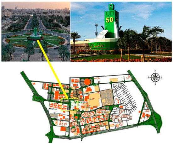
Figure 1.
Location of the 50-Years Roundabout at King Abdulaziz University (KAU).
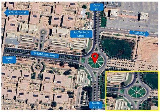
Figure 2.
Study area within the 50-Years Roundabout (Google Earth).
Addressing the traffic challenges at the 50-Years Roundabout and implementing particular Transportation System Management (TSM) strategies to improve traffic flow and enhance safety are crucial objectives for King Abdulaziz University (KAU). As mentioned earlier, KAU is one of the most significant trip attractors for educational purposes in Jeddah. According to KAU’s 2024 statistics, the university accommodates approximately 110,000 students of both genders. Based on the Jeddah Public Transport Program (JPTP) developed by the Jeddah Transport Company (JTC), approximately 98% of travelers depend on private vehicles for their daily trips []. Projecting this percentage to KAU’s population, assuming an average vehicle occupancy of 2.0 persons per vehicle, it translates to more than 50,000 vehicle trips generated by the university community. Field observations further indicate that over 60% of commuters access the campus through Gate 1, located along Al-Ehtifalat Street, to reach their destinations. The 50-Years Roundabout is located at the intersection of three major approaches: Gate 1 (Al-Ehtifalat Street), the northern campus section, and Gate 3 (Ali Murtada Street). This location is particularly strategic as it is considered as the main entrance and visual gateway to KAU. Several key facilities—such as the Deanship of Admission and Registration, King Faisal Ballroom, and the KAU Hospital—are located within walkable distance from the roundabout, further intensifying its traffic demand. According to field data -the highest demand coming from Gate 1 for the 50-Years Roundabout has led to severe vehicle delays and congestion. Recent observations state that the roundabout goes through significant delays and increased vehicular conflicts during peak hours, emphasizing the urgent need for temporary operational and geometric improvements.
4. Method and Procedures
The study employs microscopic traffic simulation using the PTV Vissim and SIDRA Intersection software to analyze traffic flow at the 50-Years Roundabout. In addition, the Surrogate Safety Assessment Model (SSAM) is utilized to evaluate safety performance by comparing conflict points before and after implementing the proposed treatment. PTV Vissim is used to model both the base condition and the proposed scenario, allowing for a comparative analysis of operational performance. Performance measures such as average delay and level of service (LOS) are used as primary indicators for evaluation. Results obtained from SIDRA Intersection are then compared with those extracted by Vissim to ensure consistency and model validation. The study also examines the effectiveness of applying Transportation System Management (TSM) strategies—particularly lane restriction and assignment techniques—as potential solutions to mitigate traffic congestion and improve overall roundabout performance.
Traffic data were collected through loop detectors and field observations conducted by three independent field teams to validate the accuracy of vehicle counts. Data collection processes covered all three approaches of the roundabout during the morning peak period (7:30 AM–8:30 AM), identified as the most congested hour of the day based on field observations, coinciding with the beginning of morning classes at 8:00 AM. As previously mentioned, and according to data from the Jeddah Transport Company (JTC), buses and high-occupancy vehicle (HOV) trips account for approximately 2% of the total traffic volume and are stochastically distributed across the network. The remaining trips are made by private passenger vehicles. Furthermore, the proposed condition is validated using a density map generated from the base condition to verify spatial consistency of congestion patterns. The capacity estimation of the roundabout is carried out using methodologies derived from the Highway Capacity Manual (HCM), as well as the empirical models proposed by Al-Madani et al. and Sindi.
4.1. HCM Model
The sixth Edition of the Highway Capacity Manual (HCM) provides procedures for analyzing roundabout performance using three primary flow components: v (entry flow rate), Vc (conflicting flow rate), and Vex (exit flow rate). Intersection analysis models typically follow either a regression-based or an analytical approach []. The regression model is developed from field data to establish relationships between geometric characteristics and performance measures such as capacity and delay. This type of model is often applied when information regarding driver behavior characteristics is incomplete or unavailable. On the other hand, analytical models, such as gap-acceptance models, are derived from traffic flow theory and field observations of driver behavior []. These models provide an analytical formulation that directly relates observed driver behavior to performance measures (e.g., capacity and delay). Both approaches are applicable to evaluating roundabout performance, and the HCM methodology incorporates elements of both in its analytical procedures []. The flow patterns within a roundabout—specifically the entering, circulating, and exiting flows—directly influence the capacity of each approach. The capacity of an approach decreases as the conflicting (circulating) flow increases. The circulating flow represents the principal source of conflict as it interacts with all entry movements. In instances where conflicts occur between circulating and entering streams, the exiting flow can further influence drivers’ gap-acceptance decisions and their reactions when entering the roundabout. Although this phenomenon is acknowledged in the HCM, it is not explicitly incorporated into the manual’s standard capacity estimation procedure, as its overall impact on total capacity is relatively limited. Multi-lane roundabouts, which feature two or more lanes on the entry and exit routes, present greater operational complexity than single-lane roundabouts due to differences in lane spacing and gap distribution. In some cases, the number of entry, exit, and turn lanes may vary across routes. Roundabouts with two traffic lanes and one or two entry and exit lanes are typically evaluated using the analytical methodology (gap acceptance). However, HCM recommends calibrating these capacity models to local conditions to represent driver behavior better and achieve greater predictive accuracy [].
The following equations are employed to estimate the capacity of the right and left entry lanes, respectively.
where
- Ce,R,pce = capacity of the right entry lane, adjusted for heavy vehicles (pc/h);
- Ce,L,pce = capacity of the left entry lane, adjusted for heavy vehicles (pc/h);
- vC,pce = conflicting flow rate (total of both lanes) (pc/h).
The first equation represents a regression-based best-fit model, which is consistent with the observed critical time periods. On the other hand, the second equation shows consistency with the observed critical time periods in both queued and non-queued conditions. Figure 3 shows the relationship between the inlet capacity of both single-lane and multi-lane roundabout entrances and the circular flow rate, expressed in passenger vehicles per hour (pc/h). As shown in the figure, the maximum inlet flow (vehicles/hour) gradually decreases with increasing circular flow [].
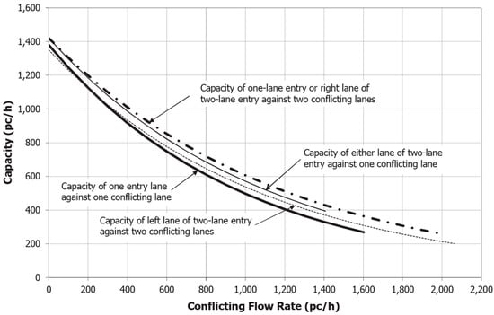
Figure 3.
Capacity of single-lane and multi-lane entries [].
4.2. Al-Madani’s Work
Al-Madani (2009) developed a model to estimate the capacity of three-lane roundabouts, particularly those with three-lane entries and three-lane circulating roadways []. The study examined 13 roundabouts in Bahrain and developed an exponential model that performed reasonably well compared with other well-known international models, including those presented in the HCM, German, and SIDRA methodologies, as illustrated in Figure 4. However, the developed model did not perform as accurately as expected, primarily due to the complexity of driver interactions and the limitations associated with estimating capacity at triple-lane roundabouts []. As a result, Al-Madani et al. emphasized the need for developing models that are more robust and adaptable to varying local and geometric conditions. The three-lane roundabout model proposed by Al-Madani is adopted in this study to estimate the entry and circulating capacities of the 50-Years Roundabout. In this analysis, all entry flows were recorded, allowing the model to be examined and applied to estimating circulating lane capacities under existing and proposed conditions.
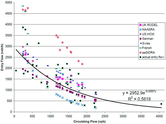
Figure 4.
Capacity of three-lane roundabout [].
The exponential equation presented below is used to estimate the capacity of the 50-Years Roundabout, which features three entry lanes and three-circulating lanes.
where
- C: Capacity of the three-entry/circulating lanes (veh/h);
- X: Conflicting traffic flow (veh/h).
4.3. Sindi’s Work
Sindi (2011) [] developed a modified capacity model based on the HCM entry-lane capacity model, integrating both gap acceptance and queuing theory approaches to estimate the capacity of single-lane roundabouts. The model was designed to be applicable to each approach (leg) of the roundabout and was calibrated using PTV Vissim. In Sindi’s formulation, pedestrian movements were assumed to occur in close proximity to the entry lanes; however, this factor is excluded in the present study since no pedestrian crossings are present at the 50-Years Roundabout. The equation below is employed in this study to support the capacity estimation process and to complement the analytical framework developed earlier [].
where
- C1c: Capacity of the circulating roadway between the exit and entry lanes of Leg 1 (veh/h);
- Vc1 = Demand on circulating roadway between the exit and entry lanes of Leg 1 (veh/h);
- Vped1 = Pedestrian demand crossing of Leg 1 in both directions combined (ped/h);
- tc = Minimum time headway within the circulating roadway traffic stream required for a vehicle on the entry lane to enter the circulating roadway (s);
- tf = Minimum time required for the non-first vehicle on the entry lane to make use of a time headway in the circulating roadway traffic stream to enter the roundabout (s);
- tc pedin = Minimum time headway within the pedestrian stream required for a vehicle on the entry lane to pass the pedestrian crossing (s) *;
- tf pedin = Minimum time required for the non-first vehicle on the entry lane to make use of time headway in the pedestrian stream to pass the pedestrian crossing (s) *.
* For this study, when there is no pedestrian crossing, tc pedin & tf pedin = 1
The equations presented above are utilized in Section 5 to estimate the capacity of the 50-Years Roundabout, and the obtained values are then compared with those derived from the HCM methodology, PTV Vissim, and SIDRA Intersection models (Figure 5).
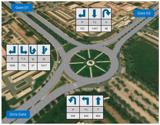
Figure 5.
Traffic counts for the base condition of all movement at the 50-Years Roundabout (PTV Vissim).
The proposed condition is aimed at reducing conflict points, thereby improving traffic flow and enhancing both operational efficiency and safety within the roundabout. Within this condition, three movements approach the circulating lanes from Gate 01, corresponding to the three available entry lanes. Each lane is dedicated for a specific movement to ensure smoother merging and minimize potential weaving conflicts. Specifically, the leftmost lane is assigned for left-turn and U-turn movements only while approaches from the north gate are restricted to two entry lanes. The right lane is dedicated for through movements only, while the middle lane accommodates left-turn and U-turn movements. The leftmost lane at this approach is closed (restricted) to prevent unnecessary conflicts and optimize lane utilization.
The approach from Gate 3 also has only two entry lanes. The right lane is designated for right-turn movements only, the middle lane is closed (restricted), and the left lane is assigned for through and U-turn movements. As illustrated in Figure 6 below, the base condition contains a total of twenty-six conflict points, comprising eight crossing, nine merging, and nine diverging conflicts. Under the proposed condition, the number of conflict points is reduced to eighteen, comprising four crossing, seven merging, and seven diverging conflicts. This means a reduction of eight conflict points, indicating a notable improvement in the roundabout’s overall safety and operational performance.
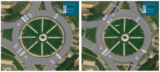
Figure 6.
Conflict points at the base (left side) and proposed (right side) conditions (PTV Vissim).
5. Results
5.1. PTV Vissim (Base Condition)
PTV Vissim Version 2025 (SP 09) is a multi-modal microscopic traffic simulation software developed by PTV Group. The software was employed to model and analyze the operational performance of the 50-Years Roundabout. The software is widely used in transportation engineering to simulate, analyze, and evaluate road networks across different modes of travel and control systems. In this study, the base condition of the 50-Years Roundabout was simulated in Vissim using 10 independent runs, each with a different random seed, to account for the stochastic nature of traffic flow and to ensure statistical reliability. The simulation was configured with a warm-up period of 900 s (15 min) followed by an evaluation period of 3600 s (1 h). A node was defined within the study area to extract performance indicators, including average delay and level of service (LOS), as summarized in Table 1. For model validation, the simulation results were compared with field data collected at the site. A density heat map, shown in Figure 7, was generated in Vissim to assess network performance visually. The map’s color scheme indicates traffic conditions: yellow represents free-flow or steady conditions, while red denotes heavy congestion and saturated flow.

Table 1.
Vissim simulation model’s result of the base condition.
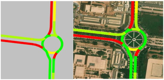
Figure 7.
Density maps of the base condition of 50-Years Roundabout (PTV Vissim).
Similarly, Google Maps was utilized to extract and verify real-time traffic conditions representing the current (base) scenario during the morning peak hour (7:30–8:30 AM). As illustrated in Figure 8 below, the two dotted black boxes highlight the red segments along Gate 01 (Al-Ehtifalat Street) and Gate 03 (Ali Murtada Street), which indicate heavy congestion and reduced traffic speeds during the observed period.
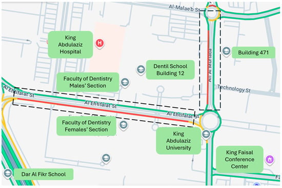
Figure 8.
Base condition of 50-Years Roundabout (Google Map).
It can be concluded that the PTV Vissim density map and Google Maps traffic data exhibit consistent results, as both highlight heavy congestion (shown in red) along Gate 1 (Al-Ehtifalat Street) and Gate 3 (Ali Murtada Street).
As shown in Table 1, the network operates at level of service (LOS) F along Link 1, which represents traffic coming from Gate 01, and along Link 5, which represents traffic from Gate 03. The average control delay is more than 2 min per vehicle, indicating severe congestion and poor operational performance under baseline conditions.
5.2. PTV Vissim (Proposed Condition)
The proposed model, which incorporates lane assignment and restriction strategies, has resulted in notable improvements in both level of service (LOS) and average delay. As demonstrated in the density maps in Figure 9 and Figure 10 below and summarized in Table 2 below, the proposed condition demonstrates a more uniform traffic distribution and substantial reductions in delay, indicating enhanced operational efficiency and overall network performance.
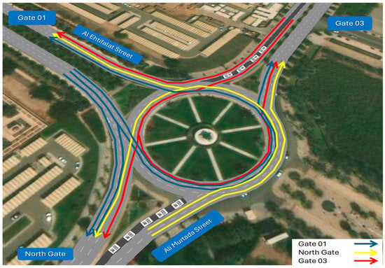
Figure 9.
Proposed condition of all movement at the 50-Years Roundabout (PTV Vissim).
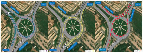
Figure 10.
Proposed condition for all movement of the three legs at the 50-Years Roundabout (PTV Vissim).

Table 2.
Vissim simulation model’s result of the proposed condition.
The density maps presented below in Figure 11 illustrate the improvements achieved under the proposed condition. The areas shown in yellow and green indicate zones of improved traffic flow and reduced congestion, while the blue lines represent the lanes restricted for exclusive use by emergency and traffic police vehicles.
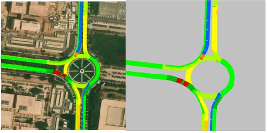
Figure 11.
Density maps of the proposed condition of 50-Years Roundabout (PTV Vissim).
Table 2 illustrates a remarkable improvement in the network’s operational performance under the proposed condition, reflected in a higher level of service (LOS) and reduced average delay. The result indicates that link 1 operates now at LOS D instead of LOS F, while link 5 has improved dramatically from LOS F to LOS A. The average control delay has decreased to approximately 13 s per vehicle, indicating a considerable enhancement in traffic flow efficiency and overall roundabout performance.
5.3. SIDRA Intersection (Base Condition)
SIDRA Intersection is a widely recognized analytical software used to analyze and evaluate the performance of various types of intersections, including roundabouts, signalized, and unsignalized junctions. The software applies the gap-acceptance method as a function of roundabout geometry to estimate entry capacity and assess overall operational performance. In this study, SIDRA Intersection was utilized to evaluate both the base and proposed conditions of the 50-Years Roundabout. The results obtained from SIDRA show close agreement with those from PTV Vissim, particularly in terms of average delay and level of service (LOS), thereby supporting the validity and consistency of the simulation findings.
Under the base conditions, analysis using the SIDRA Intersection indicates that Gate 1 and Gate 3 are operating at level of service (LOS) F, while the Girl’s Gate (North Gate) is operating at level of service (LOS) E. Overall, SIDRA reported poorer performance compared to PTV Vissim, both in terms of level of service and average control delay. These results shown below in Figure 12 and Table 3 indicate that the current traffic demand at the 50-Years Roundabout is excessively high, and that current network performance—without operational treatments or geometric modifications—is insufficient, resulting in severe congestion and long waits that can extend over long distances.
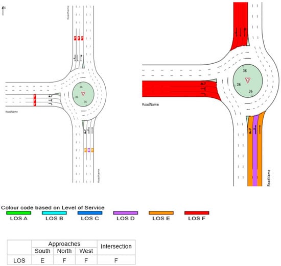
Figure 12.
SIDRA simulation model’s result of the base condition.

Table 3.
SIDRA simulation model’s result of the base condition.
5.4. SIDRA Intersection (Proposed Condition)
Under the proposed condition, the analysis using SIDRA Intersection also resulted in LOS F across all approaches. This outcome indicates that the traffic conditions remain critically congested, even after implementing the proposed treatment. Nevertheless, the average control delay was reduced by approximately 67%, which represents a substantial improvement and a noteworthy operational benefit. It is important to note that the input assumptions for the SIDRA-proposed condition differed slightly from those used in PTV Vissim. Specifically, the restricted lanes were modeled with a 1.00% assigned movement to represent emergency and traffic police vehicles, rather than being completely inactive (0%). This distinction may have contributed to the minor variation in the simulation results. As illustrated in Figure 13 below, the yellow-colored segments indicate LOS A, representing zones of free-flow conditions within the restricted-lane areas. In addition, Table 4 shows SIDRA results for the propsed condition.
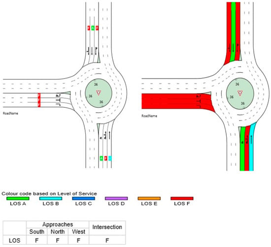
Figure 13.
SIDRA simulation model’s result of the proposed condition.

Table 4.
SIDRA simulation model’s result of the proposed condition.
5.5. Model Calibration and Statistical Analysis
The model calibration process involved comparing observed site data with simulated data generated by PTV Vissim. The model calibration used comparisons of observed and simulated flow data, as well as average speed and queue length for each approach. Data were collected at the site using detectors integrated into each approach lane to measure critical calibration parameters. The findings confirmed that the simulated data on traffic flow accurately corresponded to data collected from the site. The comparison of average speed derived from site-collected simulation data showed a deviation of ±10%, confirming the model’s accurate representation of driver behavior and car-following rules. Similarly, comparing simulated data on queue length with site measurements showed an average deviation of 15%. This validates that the model simulated site conditions accurately.
In the realm of statistical analysis, a simulation-based evaluation was conducted to assess operational effectiveness and compare outcomes from the proposed state with those from the base state. In order to incorporate the stochastic nature of driver behavior variation, 10 simulations were processed for each state with a distinct randomly generated seed. The average delay value was used as the primary evaluation criterion, and 95% CIs were derived to statistically prove the significance of the gap detected. The base state led to an average delay of roughly 134 s per vehicle with a standard deviation of 97.3 s. In comparison, the proposed state showed a substantial reduction in average delay of roughly 13 s with an 8.0 s standard deviation. The derived 95% CIs were [60.4, 207.1] for the base and [6.6, 18.6] for the proposed state. As these two values do not correspond to being comparable within a 95% CI framework on significance of difference tests at an alpha level of 0.05, it can be logically deduced that the detected gap within both states holds substantial significance at a 95% level of significance. This corroborates that a positive change of roughly 91% relative to the base state had been successfully accomplished by the proposed state.
A sensitivity analysis was also conducted to evaluate the responsiveness of the proposed model to variations in traffic demand. The traffic volume for each approach was systematically increased by 25%, 50%, 75%, and 100% to evaluate the model’s stability and applicability under different loading conditions. The results revealed that the proposed model maintained acceptable performance and operated at level of service (LOS) E under 25% and 50% increases in traffic volume. However, the model failed to sustain acceptable LOS when the volume increased by 75% and 100%, indicating a sharp deterioration in operational performance under oversaturated conditions. These findings suggest that the proposed model is applicable and reliable for use under moderate traffic demand, but its effectiveness diminishes significantly once the network reaches highly congested or oversaturated flow levels.
In addition, a sensitivity analysis was carried out to determine the responsiveness of the proposed model towards various levels of traffic flow. The traffic flow of each roadway approach was gradually expanded by 25%, 50%, 75%, and 100% of the existing original flow to test the proposed model’s stability and applicability for various loading levels. The outcomes of the analysis showed that the proposed model performed well and operated at level of service (LOS) E under 25% and 50% increases in traffic flow. However, the proposed model could not retain an acceptable LOS at 75% and 100% increases in traffic flow. Based on those outcomes of sensitivity analysis, it can be implicated that the proposed model remains valid and reliable for use at moderate levels of flow. Still, the proposed model’s applicability and efficiency decrease drastically at an increased oversaturated flow level.
5.6. Capacity
The capacity of the entry lanes for each approach at the 50-Years Roundabout varies in response to changes in the circulating traffic flow. As expected, the entry-lane capacity decreases as the circulating flow increases, due to the higher level of conflict and reduced available gaps for entering vehicles. Figure 14 below illustrates the circulating traffic flow corresponding to each approach, where the numerical values shown are utilized to estimate the entry-lane capacities. Using the capacity estimation equations presented earlier, the results summarized in Table 5 were obtained. As well, Figure 15 below illustrates the capacity estimation of entry approaches at the 50-Years Roundabout.
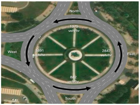
Figure 14.
Capacity of the circulating lanes of each approach (PTV Vissim).

Table 5.
Capacity estimation of entry approaches at the 50-Years Roundabout.
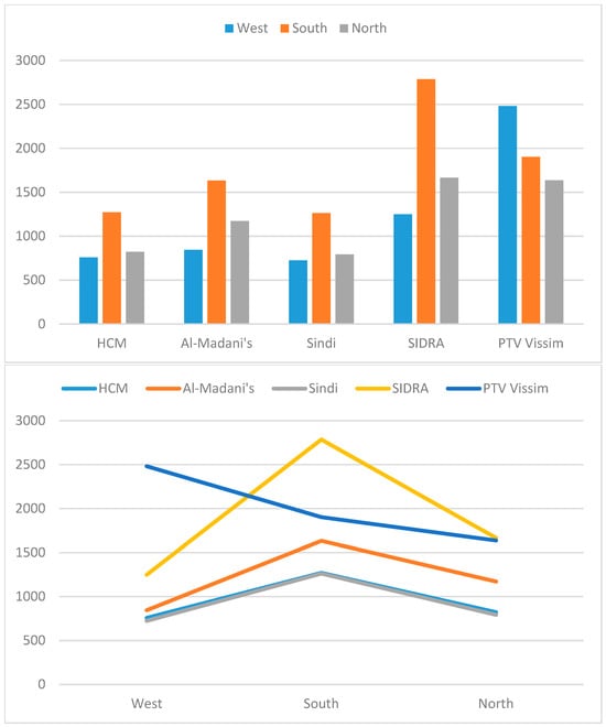
Figure 15.
Capacity estimation of entry approaches at the 50-Years Roundabout.
As presented in the table above, the differences between the HCM and Sindi models are minimal and statistically insignificant. The Al-Madani model performs reasonably well for three-lane entries, but it fails to accurately estimate the capacity for two-lane entries with three-circulating lanes, as it was originally developed for three-entry and three-circulating lane configurations. Both SIDRA Intersection and PTV Vissim tend to overestimate capacity, and therefore, neither model provides sufficiently reliable estimates for this specific roundabout configuration. In contrast, Sindi’s model yielded the lowest capacity values, which can be attributed to its analytical foundation that explicitly considers gap-acceptance behavior, headway distribution, and pedestrian interactions (when present).
The results obtained for the base condition are consistent with the field observations, where high congestion levels were recorded at Gate 01 (Al-Ehtifalat Street) and Gate 03 (Ali Murtada Street). It is evident that the approaches from Gates 01 and 03 experience severe congestion, reflecting higher traffic demand and operating at level of service (LOS) F, in contrast to the North Gate, which operates at LOS A. The explanation for this pattern is straightforward. Gate 01 serves as the main entrance to KAU, providing access to several key destinations around the 50-Years Roundabout, including—but not limited to—the Deanship of Admission and Registration, King Faisal Ballroom, KAU Hospital, and various academic colleges. Similarly, Gate 03 serves as the access route to several major colleges, such as the College of Engineering, English Language Institute, and College of Science, which collectively contribute to its high traffic demand. Additional contributing factors are linked to driver behavior, particularly the ineffective compliance with the yield-at-entry rule within the roundabout. This non-compliance increases the likelihood of traffic conflicts and potential crash exposure, thereby worsening operational conditions at these approaches.
The proposed model has made a substantial improvement in the operational performance of the proposed roundabout along all gates. The reduction in conflict points has led to an improved flow of traffic predominantly due to the proposed model’s capacity to release these vehicles better without generating constant braking. In addition to addressing congestion emerging from Gate 01, several intervention strategies may also be used. These may include diverting some of these incoming flows via alternate exits and organizing class and work timing to ensure more balanced peak flow. The proposed model analysis in the PTV Vissim simulation has made improvements to both the level of service and average delay. The average delay has been reduced from 131 s per vehicle to 13 s per vehicle. In other words, an 89% decrease in delays has been observed. These outcomes illustrate that the proposed scenario has made improvements to traffic flow by providing reduced delays and improved levels of service for the system. Based on the analysis of the density maps, there has been substantial enhancement of flow at Gate 03 (Ali Murtada Street) due to the reduced conflict points and the minimizing potential exposure to conflicts by the restricted lane configuration of the proposed model. This reduces exposure to potential conflicts and relates to providing stability to the proposed roundabout.
5.7. Safety
The Surrogate Safety Assessment Model (SSAM) was utilized to evaluate traffic safety performance and to compare the base and proposed conditions in terms of conflict type and severity. The software, developed by the Federal Highway Administration (FHWA), provides a robust analytical framework for assessing traffic safety through vehicle conflict analysis. In this study, SSAM was employed to analyze vehicle trajectory files generated from PTV Vissim simulations. SSAM classifies conflicts by conflict angle, identifying three primary types: rear-end, lane-change, and crossing. In addition, it assesses the severity of each conflict using the Time-to-Collision (TTC) metric. Figure 16 illustrates the number and types of conflicts for the base condition, whereas Figure 17 presents the same outputs for the proposed condition. A notable reduction in conflicts is observed between the two scenarios. Under the base condition, a total of 1141 conflicts were recorded, consisting of 839 rear-end, 300 lane-change, and 2 crossing conflicts. In contrast, the proposed condition produced only 32 conflicts, including 29 rear-end and 3 lane-change conflicts. This represents an approximate 97% reduction in total conflicts, demonstrating a substantial improvement in safety performance. These findings clearly indicate that the restricted-lane configuration significantly reduces potential conflict points, thereby enhancing traffic safety and promoting more stable and predictable traffic operations within the roundabout.
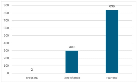
Figure 16.
Count of conflict type for the base condition.
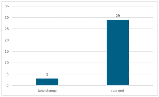
Figure 17.
Count of conflict type for the proposed condition.
5.8. Toxic Emissions
In addition to the traffic flow analysis, vehicle emissions were assessed to identify differences between the base and proposed scenarios. The PHEMlight model, part of Vissim, was used to estimate the toxic emissions produced by vehicles during the simulation. In Vissim analysis, toxic emissions consist of three primary pollutants: carbon monoxide (CO), nitrogen oxides (NOx), and volatile organic compounds (VOCs). Figure 18 compares emission levels between the base and proposed scenarios. The figure depicts the influence of the lane restriction technique applied at the 50-Years Roundabout.
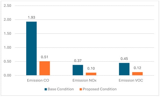
Figure 18.
Toxic emissions for the base and proposed condition (g/veh-km).
A substantial improvement can be observed when comparing the base and proposed conditions in terms of vehicular emissions. Carbon monoxide (CO) levels were reduced significantly from 1.93 g/veh-km to 0.51 g/veh-km, representing a 74% reduction. Similarly, nitrogen oxides (NOx) decreased from 0.37 g/veh-km to 0.10 g/veh-km, corresponding to an approximate 73% reduction. The same trend was observed for volatile organic compounds (VOCs), which declined from 0.45 g/veh-km to 0.12 g/veh-km, indicating a 73% reduction. Overall, the implementation of the restricted and assigned lane strategy has made a significant contribution to reducing vehicular emissions. These results highlight how such a traffic management approach can positively influence environmental performance, enhance sustainability, and promote healthier urban living conditions.
Although the primary discussion of this paper considers toxic emissions generated by vehicles, sustainability involves a far more comprehensive approach that incorporates factors such as social, economic, and environmental dimensions. For instance, a sustainable transport solution not only needs to offer low toxic emissions but should also ensure healthy living standards, increased security, minimized travel time and expenses, and an overall improved quality of life. The subject of sustainable transport thus encompasses a broader approach that seeks to improve human life.
6. Discussion
The outcome of the base model performs well as it relates to the observations obtained from the field measurements. High congestion levels were observed at Gate 01 (Al-Ehtifalat Street) and Gate 03 (Ali Murtada Street). Clearly, these two entries encountered severe congestion levels due to high traffic flow demand; thus, they work at the LOS F level of service as compared to the North Gate that works at LOS level A. The reasoning behind such an outcome appears straightforward. Gate 01 represents the primary entry point of King Abdulaziz University (KAU), giving access to important destinations around the 50-Years Roundabout such as Deanship of Admission and Registration, King Faisal Ballroom, KAU Hospital, and various academic colleges. Similarly, Gate 03 offers access towards important educational destinations such as the College of Engineering, English Language Institute, and College of Science. These factors cumulatively create a heavy demand for these entries. The additional factor that comes into play relates to the driver’s poor adherence to the yield-at-entry rule of the existing roundabout. This factor cumulatively increases the vulnerability of such entries towards potential exposure to traffic conflicts due to increased levels of congestion.
The proposed model shows noticeable improvements in the operational performance of the roundabout along all gates. The reduction in conflict points has led to improved flow of traffic, mainly due to the easier release of vehicles from the model, thereby reducing frequent and rapid stops. In addition to these adjustments, in order to offset congestion caused by arrivals at Gate 01, various measures such as the dispersal of incoming flow through adjacent gates and work-class schedule coordination to manage peak hours may be implemented. The simulation outcomes of the proposed model using PTV Vissim analyze substantial improvements in both level of service and average delay. The average delay reduces from 134 s per vehicle to 13 s per vehicle, and an overall 91% decrease in delay is obtained. These analysis outcomes undoubtedly state that the proposed model functions as an effective approach that assists in enhancing the flow of traffic. The controlled lane approach as depicted from the density maps lowers the flow of traffic as it decreases conflict points by minimizing exposure to potential conflicts on Gate 03 (Ali Murtada Street), thereby contributing towards improved and efficient operations at the roundabout.
The differences observed between the results obtained from PTV Vissim and SIDRA Intersection were expected, given the fundamental differences in their modeling approaches. Vissim employs a stochastic microscopic simulation framework that models each vehicle individually, considering multiple dynamic factors such as speed, headways, and lane-changing behavior. In addition, Vissim accounts for complex traffic phenomena that SIDRA does not explicitly capture, including fluctuations in flow, shockwave propagation, and queue spillbacks. In contrast, SIDRA Intersection adopts a deterministic analytical approach based on the Highway Capacity Manual (HCM) methodology. The HCM equations for delay and capacity are simplified, as the method was developed under the assumption of uniform and steady-state traffic conditions. As a result, the Vissim outputs provide a more realistic representation of actual traffic operations, since the software accounts for the stochastic variation in driver behavior and traffic interactions to a much greater extent than SIDRA. Furthermore, the PHEMlight model integrated within Vissim was utilized to estimate fuel consumption and CO2 emissions. Although the model is calibrated using European vehicle data, the relative differences between scenarios remain valid, as the same fleet composition was assumed in all simulation runs.
The differences noted in the comparison of the outcomes from the PTV Vissim and SIDRA Intersection simulation software were expected due to the vastly differing underlying approaches followed by the two software. Vissim follows a stochastic microscopic simulation approach that models the behavior of each vehicle on the road separately based on various dynamic parameters such as speed, headways, and lane changes. In addition, Vissim incorporates a complex traffic flow phenomenon that SIDRA Intersection misses. These include variations in flow rates, propagation of shockwaves, and queue overflow. The SIDRA Intersection follows a deterministic analysis approach using the Highway Capacity Manual Method. The formulas used in the HCM to compute capacity and delay were made simpler as it assumed uniform and steady-state conditions on the road. Hence, Vissim’s outputs better represent real-world road operations since it incorporates the stochastic variation in driver behavior and interactions much better than SIDRA. In addition to that, Vissim uses the PHEMlight model to determine fuel consumptions as well as the emission levels of carbon dioxide. Although the model is calibrated using European vehicle data, the relative differences between scenarios remain valid, as the same fleet composition was assumed in all simulation runs.
The overall findings of this study provide new insights into how temporary lane restrictions can positively influence traffic flow at the 50-Years Roundabout. These results support the theoretical hypothesis that operational lane management strategies can serve as proactive control measures to mitigate localized traffic shockwaves and enhance overall network stability and efficiency.
7. Recommendations
Implementing the restricted and assigned lane strategy can play a significant role in reducing congestion, delay, and travel time by minimizing conflict points at the 50-Years Roundabout. However, applying such lane restrictions as part of a Transportation System Management (TSM) strategy during peak hours requires raising awareness among students and visitors regarding the new traffic arrangements. Furthermore, the success of this strategy depends on the effective use of traffic control devices (TCDs)—including regulatory signs, traffic cones, and delineators—supported by the presence of traffic police officers along the study area to guide and redirect drivers, ensuring compliance and preventing unauthorized use of restricted lanes during peak periods.
8. Limitation
Though this study provides insightful information on operational performance and sustainability considerations of lane restriction strategies, several limitations are to be highlighted. First, the analysis is conducted at one specific location—the 50-Years Roundabout—that has specific geometric and traffic characteristics that cannot be taken to represent the general case for other roundabouts. Second, driver behavioral parameters were calibrated using limited field observations; additional data collection would help strengthen the robustness and accuracy of the model. Third, the study employed primarily simulation-based performance indicators; inclusion of empirical before-and-after field observations in future work would facilitate stronger testing of the model’s effectiveness in practice. Fourth, the analysis was limited to a certain range of traffic volumes, and the sensitivity analysis showed that the model performed poorly under very congested (over-saturation) conditions. Hence, the framework can be extended to compare performance across different demand levels and operational conditions. Future studies would further explore the extension of assigned and restricted lane strategies to four-legged (multi-leg) roundabouts and incorporate region-specific emission models such as MOVES or locally calibrated Saudi Arabian emission factors for higher environmental correctness and local relevance.
9. Conclusions
Traffic congestion is one of the direct consequences of increased travel demand that should be addressed immediately with effective measures to relieve road networks from excessive congestion and delay. Addressing the traffic challenges at the 50-Years Roundabout through the implementation of Transportation System Management (TSM) strategies is thus necessary for enhancing traffic flow and safety at King Abdulaziz University (KAU). KAU is among the most distinguished academic centers in Jeddah city, and the 50-Years Roundabout serves as a critical node within its transportation network. As a result of its strategic and central location, the roundabout links various major academic, administrative, and medical buildings such as the KAU Hospital and surrounding colleges. The existing operational condition of the roundabout suffers from heavy congestion, with average delays reaching up to two minutes per vehicle, against only 13 s per vehicle for the proposed condition. This stark contrast highlights the significant performance improvement achievable through TSM-based lane management strategies.
The proposed strategy involves applying partial lane restrictions and limiting vehicle movements to specific lanes during morning peak hours. The results illustrated significant improvements in both level of service (LOS) and average delay, in addition to a significant reduction in toxic emissions and conflict types. The proposed treatment proved to be applicable and effective at the 50-Years Roundabout, regardless of the prevailing traffic conditions at the entrances of Gate 01 (Al-Ehtifalat Street) and Gate 03 (Ali Murtada Street). These gates, which currently experience high traffic demand, could further benefit from the implementation of additional low-cost mitigation measures to enhance overall traffic conditions—a topic that lies beyond the scope of this study and warrants further investigation in future research.
The significant reduction in vehicle emissions following the implementation of the restricted- and dedicated-lane strategy is expected to play a crucial role in promoting sustainable urban living. High levels of carbon monoxide (CO), nitrogen oxides (NOₓ), and volatile organic compounds (VOCs) are known to negatively impact air quality, which, in turn, affects public health and the overall quality of life. Therefore, the noticeable decrease in these pollutants highlights the environmental benefits of adopting Transport System Management (TSM) strategies. To enhance the effectiveness of the implemented TSM measures, it is recommended to raise awareness among students and visitors about the lane restriction policy and its objectives. Furthermore, the deployment of traffic control devices (TCDs)—such as signs, cones, and delineators —supported by a traffic police presence along the study area, will help redirect drivers and ensure compliance with lane restrictions during peak hours, thereby improving both traffic management and environmental sustainability.
Author Contributions
Conceptualization, A.R.S. and H.S.T.; methodology, A.R.S. and H.S.T.; software, H.S.T. and A.S.A.; validation, H.S.T., A.S.A., and A.R.S.; formal analysis, H.S.T., A.S.A., and A.R.S. investigation, H.S.T., A.S.A., and A.R.S.; resources, H.S.T. and A.S.A.; data curation, A.R.S. and H.S.T.; writing—original draft preparation, A.R.S. and H.S.T.; writing—review and editing, H.S.T. and A.S.A.; visualization, H.S.T. and A.S.A.; supervision, A.R.S. and A.S.A.; project administration, A.R.S. and A.S.A.; funding acquisition, A.R.S. and A.S.A. All authors have read and agreed to the published version of the manuscript.
Funding
This project was funded by the Deanship of Scientific Research (DSR) at King Abdulaziz University, Jeddah, under grant no. (J: 63-135-1441). The authors, therefore, acknowledge with thanks DSR for technical and financial support.
Institutional Review Board Statement
Not applicable.
Informed Consent Statement
Not applicable.
Data Availability Statement
The original contributions presented in this study are included in the article. Further inquiries can be directed to the corresponding authors.
Conflicts of Interest
The authors declare no conflict of interest.
References
- Ahmed, H.; Easa, S.M. Multi-objective evaluation model of single-lane roundabouts. Transp. Res. Rec. 2021, 2675, 395–410. [Google Scholar] [CrossRef]
- Gkyrtis, K.; Kokkalis, A. An overview of the efficiency of roundabouts: Design aspects and contribution toward safer vehicle movement. Vehicles 2024, 6, 433–449. [Google Scholar] [CrossRef]
- Abolhassani, M.; Hassan, Y.; Kassim, A. Safety Impacts of Converting Stop-Controlled Intersections in Ottawa to Roundabouts. In Proceedings of the 8th International Conference on Civil Structural and Transportation Engineering (ICCSTE’23), Ottawa, ON, Canada, 4–6 June 2023. [Google Scholar]
- Severino, A.; Pappalardo, G.; Curto, S.; Trubia, S.; Olayode, I.O. Safety evaluation of flower roundabout considering autonomous vehicles operation. Sustainability 2021, 13, 10120. [Google Scholar] [CrossRef]
- Naeem, R.; Shoaib, R.M.; Ahmed, Z.; Razaq, A. A Literature Survey on Signalized and Non-Signalized Corridors. J. Syntax. Transform. 2024, 5, 1179–1187. [Google Scholar] [CrossRef]
- Hassan, M.; Al Nafees, A.; Shraban, S.S.; Mahin, H.D.; Paul, A.; An, H.K. A Comprehensive Review on the Impact of Gap Parameters for Multiple Types of Roundabouts in Different Traffic Conditions. Int. J. Integr. Eng. 2024, 16, 1–20. [Google Scholar] [CrossRef]
- Gallelli, V.; Perri, G.; Vaiana, R. Operational and safety management at intersections: Can the turbo-roundabout be an effective alternative to conventional solutions? Sustainability 2021, 13, 5103. [Google Scholar] [CrossRef]
- Salwan, A.; Easa, S.M.; Raju, N.; Arkatkar, S. Intersection sight distance characteristics of turbo roundabouts. Designs 2021, 5, 16. [Google Scholar] [CrossRef]
- Ren, L.; Qu, X.; Guan, H.; Easa, S.; Oh, E. Evaluation of roundabout capacity models: An empirical case study. J. Transp. Eng. 2016, 142, 04016066. [Google Scholar] [CrossRef]
- Scott, J.; Gordon, L. A Review of the Literature on Design and Performance of Multi Lane Roundabouts in Canada: The Case for Turbo Roundabouts. In Proceedings of the Canadian Society of Civil Engineering Annual Conference, Online, 26–29 May 2021; Springer Nature: Singapore, 2021; pp. 291–303. [Google Scholar]
- Leonardi, S.; Distefano, N. Turbo-roundabouts as an instrument for improving the efficiency and safety in urban area: An Italian case study. Sustainability 2023, 15, 3223. [Google Scholar] [CrossRef]
- Elhassy, Z.; Abou-Senna, H.; Shaaban, K.; Radwan, E. The Implications of Converting a High-Volume Multilane Roundabout into a Turbo Roundabout. J. Adv. Transp. 2020, 2020, 5472806. [Google Scholar] [CrossRef]
- Ma, J.; Wu, X.; Jiang, J. Lane restriction system to reduce the environmental cost of urban roads. Transp. Res. Part D Transp. Environ. 2023, 115, 103575. [Google Scholar] [CrossRef]
- Khattak, Z.H.; Smith, B.L.; Fontaine, M.D.; Ma, J.; Khattak, A.J. Active lane management and control using connected and automated vehicles in a mixed traffic environment. Transp. Res. Part C Emerg. Technol. 2022, 139, 103648. [Google Scholar] [CrossRef]
- Megat-Johari, N.; Megat-Johari, M.U.; Savolainen, P.; Gates, T.; Kassens-Noor, E. Examining driver compliance with a move-over/slow down law in consideration of vehicle type and messages displayed on upstream dynamic message signs. Transp. Res. Rec. 2021, 2675, 92–102. [Google Scholar] [CrossRef]
- Halawani, A.T. Advanced Techniques for Transit Priority at Roundabouts utilizing Signal Metering. Eng. Technol. Appl. Sci. Res. 2025, 15, 21611–21617. [Google Scholar] [CrossRef]
- Tumminello, M.L.; Macioszek, E.; Granà, A.; Giuffrè, T. A methodological framework to assess road infrastructure safety and performance efficiency in the transition toward cooperative driving. Sustainability 2023, 15, 9345. [Google Scholar] [CrossRef]
- King Abdulaziz University. An Overview of King Abdulaziz University Establishment. 2019. Available online: https://kau.edu.sa/en/page/historical-overview (accessed on 10 August 2025).
- Sindi, A. Conceptual intelligent travel demand modelling framework for universities: Case study—King Abdulaziz University. E3S Web Conf. 2022, 347, 01019. [Google Scholar] [CrossRef]
- Nambisan, S.S.; Parimi, V. A comparative evaluation of the safety performance of roundabouts and traditional intersection controls. ITE J. 2007, 77, 18. [Google Scholar]
- Li, Y.; Pan, B.; Chen, Z.; Xing, L. Developing a dynamic speed control system for mixed traffic flow to reduce collision risks near freeway bottlenecks. IEEE Trans. Intell. Transp. Syst. 2023, 24, 12560–12581. [Google Scholar] [CrossRef]
- Federal Highway Administration. Safety Design: Roundabouts; Publication No. FHWA-HRT-06-047; U.S. Department of Transportation: Washington, DC, USA, 2006. Available online: https://highways.dot.gov/media/9206 (accessed on 10 August 2025).
- Federal Highway Administration. Roundabouts: An Informational Guide; Publication No. FHWA-RD-00-067; U.S. Department of Transportation: Washington, DC, USA, 2000. Available online: https://www.fhwa.dot.gov/publications/research/safety/00067/00067.pdf (accessed on 12 August 2025).
- Leong, L.V.; Shafie, S.M. Traffic emissions before and after development based on traffic impact assessment. IOP Conf. Ser. Earth Environ. Sci. 2024, 1368, 012012. [Google Scholar] [CrossRef]
- Sulaiman, M.; Ramli, N.A.; Ibrahim, W.H.W.; Rasli, N.B.I.; Ismail, M.R.; Shith, S. Traffic emissions due to changes in road layout in developing township related to double track rail project constructions. Curr. World Environ. 2022, 17, 557. [Google Scholar] [CrossRef]
- Várhelyi, A. The effects of small roundabouts on emissions and fuel consumption: A case study. Transp. Res. Part D Transp. Environ. 2002, 7, 65–71. [Google Scholar] [CrossRef]
- Pulvirenti, G.; Distefano, N.; Leonardi, S.; Tollazzi, T. Are double-lane roundabouts safe enough? A chaid analysis of unsafe driving behaviors. Safety 2021, 7, 20. [Google Scholar] [CrossRef]
- Tumminello, M.L.; Macioszek, E.; Granà, A.; Giuffrè, T. Simulation-based analysis of “what-if” scenarios with connected and automated vehicles navigating roundabouts. Sensors 2022, 22, 6670. [Google Scholar] [CrossRef] [PubMed]
- Johnson, M.T. Effects of phi and view angle geometric principles on safety of multi-lane roundabouts. Transp. Res. Rec. 2023, 2677, 362–371. [Google Scholar] [CrossRef]
- Granà, A.; Giuffrè, T.; Macioszek, E.; Acuto, F. Estimation of passenger car equivalents for two-lane and turbo roundabouts using AIMSUN. Front. Built Environ. 2020, 6, 86. [Google Scholar] [CrossRef]
- Liu, Q.; Deng, J.; Shen, Y.; Wang, W.; Zhang, Z.; Lu, L. Safety and efficiency analysis of turbo roundabout with simulations based on the Lujiazui roundabout in Shanghai. Sustainability 2020, 12, 7479. [Google Scholar] [CrossRef]
- aele Mauro, R.; Cattani, M.; Guerrieri, M. Evaluation of the Safety Performance of Turbo Roundabouts by Means of a Potential Accident Rate Model. Balt. J. Road Bridge Eng. 2015, 10, 28–38. [Google Scholar] [CrossRef]
- Gallelli, V.; Vaiana, R. Safety improvements by converting a standard roundabout with unbalanced flow distribution into an egg turbo roundabout: Simulation approach to a case study. Sustainability 2019, 11, 466. [Google Scholar] [CrossRef]
- Kalašová, A.; Skřivánek Kubíková, S.; Čulík, K.; Palúch, J. Comparison of traffic flow characteristics of signal controlled intersection and turbo roundabout. Arch. Motoryz. 2020, 88, 19–36. [Google Scholar]
- Macioszek, E.; Kurek, A. A case study analysis of roundabouts entry capacity localised on one of the main road in Sosnowiec city (Poland). Zesz. Nauk. Transp./Politech. Śląska 2019, 105, 139–156. [Google Scholar] [CrossRef]
- Fernandes, P.; Teixeira, J.; Guarnaccia, C.; Bandeira, J.M.; Macedo, E.; Coelho, M.C. The potential of metering roundabouts: Influence in transportation externalities. Transp. Res. Rec. 2018, 2672, 21–34. [Google Scholar] [CrossRef]
- Wang, R.; Hu, J.; Zhang, X. Analysis of the driver’s behavior characteristics in low volume freeway interchange. Math. Probl. Eng. 2016, 2016, 2679516. [Google Scholar] [CrossRef]
- Finley, M.D.; Ullman, B.R. Field evaluation of in-lane pavement markings in advance of freeway interchanges. Transp. Res. Rec. 2011, 2250, 32–40. [Google Scholar] [CrossRef]
- Bakibillah, A.S.M.; Kamal, M.A.S.; Tan, C.P.; Susilawati, S.; Hayakawa, T.; Imura, J.I. Bi-level coordinated merging of connected and automated vehicles at roundabouts. Sensors 2021, 21, 6533. [Google Scholar] [CrossRef] [PubMed]
- Zadobrischi, E. Traffic and Vehicle Management in Roundabouts Through Systems Based on Dedicated Short-Range Communications and Visible Light Communications. Electronics 2025, 14, 317. [Google Scholar] [CrossRef]
- Talebpour, A.; Mahmassani, H.S.; Elfar, A. Investigating the effects of reserved lanes for autonomous vehicles on congestion and travel time reliability. Transp. Res. Rec. 2017, 2622, 1–12. [Google Scholar] [CrossRef]
- Al-Turkman, A.; Al-Azzawi, A. A case study on roundabout under congestion: Proposal to improve current traffic operation. Civ. Eng. J. 2019, 5, 2029–2040. [Google Scholar] [CrossRef]
- Hong, E.E.M.; Bong, J.B.; Ting, J.L.S. Roundabout capacity analysis based on drivers’ lane utilization at large multi-lane roundabout during peak and off-peak hours. AIP Conf. Proc. 2023, 2712, 040004. [Google Scholar] [CrossRef]
- Jeddah Public Transport Program, Jeddah Public Transport Program (JPTP). Available online: https://www.jedtc.com.sa/page/JPTP (accessed on 16 March 2025).
- Transportation Research Board. Highway Capacity Manual (HCM 6th Edition): A Guide for Multimodal Mobility Analysis; National Academy of Sciences, Transportation Research Board: Washington, DC, USA, 2016; Chapter 22. [Google Scholar]
- Al-Madani, H. Analysis of roundabout capacity under high demand flows. WIT Trans. Built Environ. 2009, 107, 223–232. [Google Scholar] [CrossRef]
- Sindi, A. Impact of Pedestrian Volumes on the Operational Performance of Modern Roundabouts. Master’s Thesis, University of Waterloo, Waterloo, ON, Canada, 2011. [Google Scholar]
Disclaimer/Publisher’s Note: The statements, opinions and data contained in all publications are solely those of the individual author(s) and contributor(s) and not of MDPI and/or the editor(s). MDPI and/or the editor(s) disclaim responsibility for any injury to people or property resulting from any ideas, methods, instructions or products referred to in the content. |
© 2025 by the authors. Licensee MDPI, Basel, Switzerland. This article is an open access article distributed under the terms and conditions of the Creative Commons Attribution (CC BY) license (https://creativecommons.org/licenses/by/4.0/).