Abstract
Urbanization and the growing scarcity of surface land resources have highlighted the strategic importance of underground space as a critical component of sustainable urban infrastructure. This study presents a multi-objective optimization framework for underground infrastructure planning around transit hubs, aligning with the principles of Transit-Oriented Development (TOD). By integrating an agent-based model (ABM) with the Non-dominated Sorting Genetic Algorithm II (NSGA-II) and incorporating the Technique for Order Preference by Similarity to Ideal Solution (TOPSIS), the framework forms a unified evaluation and optimization tool that accounts for user behavior while addressing competing objectives, including minimizing evacuation time and functional conflicts, maximizing functional efficiency, and reducing layout deviations. Using Qingdaobei Railway Station in China as a case study, the method yields notable improvements: a 15% reduction in evacuation time, a 16% increase in development benefits, and a more balanced spatial configuration. Beyond technical gains, the study also discusses station planning and governance under the TOD policy context, highlighting how integrated layouts can alleviate congestion, strengthen functional synergy, and support sustainable urban development.
1. Introduction
With the accelerating pace of urbanization and the increasing scarcity of surface land resources, the development and utilization of underground space have emerged as a critical strategy in modern urban infrastructure planning. Particularly within the framework of Transit-Oriented Development (TOD), the integrated planning of underground space around rail transit hubs is essential, as it serves not only to maximize land use efficiency but also to guide the orderly spatial expansion of cities and enhance the quality of life for residents. The United Nations’ New Urban Agenda identifies TOD as a key pathway toward sustainable urban development, advocating compact, connected, and multifunctional urban forms. TOD promotes high-density, mixed-use spatial configurations that seamlessly integrate surface and subsurface infrastructure systems. Under this model, coordinated planning of underground facilities such as commercial areas, parking lots, pedestrian corridors, and utility networks expands urban capacity and enables more efficient multimodal interactions.
Moreover, by improving spatial connectivity and functional synergy, TOD-based underground infrastructure contributes to a more accessible and livable urban environment. A well-designed configuration of underground commercial areas, pedestrian corridors, and transit transfer halls enhances the functional performance of urban infrastructure. Such integrated spatial arrangements reduce walking distances, improve accessibility and user experience in public transportation systems, and facilitate smoother passenger transfers. In addition, they contribute to the dispersion of pedestrian flows and strengthen the system’s resilience to emergencies and disasters. Collectively, these improvements foster a more efficient, adaptable, and livable urban environment, aligning with the broader goals of sustainable infrastructure planning.
In recent decades, the concept of TOD has evolved from a planning paradigm emphasizing compact, mixed-use neighborhoods into a multidisciplinary framework integrating land-use, transport, and sustainability perspectives. Early studies framed TOD within urban planning and transport geography, highlighting density, diversity, and design as core dimensions of transit accessibility [,]. Subsequent research expanded the debate to include environmental sustainability and social equity, thus positioning TOD as a strategic tool for low-carbon urban development [,]. More recent studies have applied quantitative and computational approaches to TOD planning, such as integrated land-use–transport models and multi-objective optimization frameworks [,,]. These efforts reflect an ongoing shift from conceptual frameworks toward data-driven and evidence-based TOD applications, which form the disciplinary foundation of this study.
A central focus of infrastructure planning within the TOD model is the effective utilization of Underground Space Synchronously with Metro Stations (USSMS). As defined by Dong et al. [], USSMS refers to underground spaces that are deeply integrated with metro stations in both spatial configuration and functional operations. Serving as high-efficiency urban catalysts, these integrated systems play a pivotal role in promoting the coordinated development of urban areas centered around transit infrastructure. In rapidly urbanizing countries such as China, the expansion of infrastructure such as metro networks has driven the widespread construction of USSMS projects in the core zones of major cities [,]. However, during the early phases of metro development, the prevailing approach often prioritized rapid implementation and project scale, with limited attention to the integration of USSMS into the broader urban fabric. Additionally, decision-making processes were frequently shaped by the subjective preferences of individual planners [], rather than by systematic, evidence-based methodologies. As such, developing rational and efficient design strategies for USSMS and their surrounding environments has become a pressing challenge for achieving high-quality, sustainable, and integrated TOD-based urban infrastructure.
Inadequate or poorly integrated infrastructure planning can give rise to a range of functional and operational challenges [,]. First, the co-location of commercial facilities, parking areas, and municipal infrastructure without proper coordination may result in spatial inefficiencies and pedestrian congestion. For instance, Tiyu Xilu Station of the Guangzhou Metro, which was constructed during an earlier phase of development, exemplifies the consequences of weak integration between transit infrastructure and the surrounding urban context. The station now experiences excessive passenger volumes, necessitating periodic crowd control measures. Similar issues have been reported at major transit hubs in cities such as Beijing and Shanghai [,]. These conditions not only compromise pedestrian safety but also underscore the need to reconcile safety requirements with the commercial viability of underground spaces. Mismanagement of these trade-offs may lead to commercial underperformance and long-term spatial underutilization in TOD areas []. Another critical concern is determining an appropriate development scale. Oversized underground spaces often result in elevated maintenance costs and unnecessary carbon footprint [], while underdeveloped ones may fail to generate the agglomeration benefits central to the TOD model. Therefore, it is imperative to explore effective planning and design strategies from the earliest stages of underground infrastructure development to ensure the integrated and sustainable utilization of USSMS within the TOD framework.
Within the TOD framework, the planning and development of USSMS confront several critical challenges, including safety risks, functional conflicts, benefit optimization, and appropriate scale control []. Traditional planning approaches have often relied on empirical judgment and rule-based constraints, lacking the analytical rigor and quantitative support necessary for addressing complex, multi-objective trade-offs []. As a result, such methods struggle to deliver optimal or adaptable infrastructure solutions. In contrast, data-driven optimization techniques offer a more robust foundation for infrastructure planning by systematically incorporating diverse functional requirements, investment returns, and spatial constraints into the decision-making process []. As the TOD model continues to evolve and underground space systems grow more complex, leveraging quantitative optimization methods becomes increasingly essential. These approaches enhance the scientific rigor, adaptability, and system-level integration of planning practices, thereby enabling more resilient and sustainable infrastructure development [].
In recent years, significant advances have been made in the development of intelligent models for planning USSMS, contributing to more sophisticated infrastructure planning frameworks. For instance, Xu and Chen [], drawing on development experiences from metro stations in Japan, proposed six typological models for integrated underground space development—block-type, strip-type, cross-axis, L-shaped, hybrid, and networked—based on morphological characteristics. Mohammadi et al. [] formulated an optimization model for urban rail transit network design, while Shao and Wang [] introduced analytic hierarchy processes and complexity evolution models for visualizing underground systems, along with a coordination model based on digital twin technology. Zhang et al. [] applied an Artificially Intervened Genetic Algorithm (AIGA), incorporating principles of layered and hierarchical development, to generate two- and three-dimensional urban spatial layouts. Peng et al. [] proposed a conceptual data-driven framework for Underground Urban Space (UUS) planning guided by multiple development concepts through keyword co-occurrence network analysis. Despite these advancements, studies specifically targeting intelligent optimization for integrated USSMS planning remain limited. Existing research tends to focus on isolated components, such as transit systems or commercial functions, rather than on holistic spatial strategies under a comprehensive TOD framework. This underscores the need for integrated, multi-objective, and data-driven models capable of addressing the complexity of USSMS development within sustainable urban infrastructure systems. In parallel, progress in data-efficient perception has emerged from machine learning, where few-shot learning improves object detection under limited annotations and complex environments, suggesting potential to enhance spatial sensing and model adaptability in planning workflows [].
In this regard, computational planning schemes represent a departure from conventional static and experience-based methods. By combining NSGA-II with dynamic ABM simulation, this study adopts a heuristic, scenario-generating approach that reveals trade-offs among conflicting objectives, rather than prescribing fixed solutions. Such a model enables planners to explore adaptive, evidence-based strategies under TOD constraints, marking a paradigm shift toward algorithm-assisted spatial decision-making.
To provide a structured overview of existing research, Table 1 summarizes representative studies on metro-oriented underground space planning and optimization. While prior studies have addressed specific aspects such as spatial compatibility, morphological typologies, or data-driven conceptual approaches, most have not adopted a holistic and operationally integrated optimization framework that aligns with TOD principles. In contrast, the present study brings together multiple key dimensions—including pedestrian evacuation, spatial conflict, development benefits, and functional allocation ratios—within a unified model that combines NSGA-II optimization with ABM simulation and TOPSIS-based decision-making.
Table 1.
Summary of representative studies on metro TOD-related underground space planning and optimization methods.
Non-dominated Sorting Genetic Algorithm II (NSGA-II) is an enhanced evolutionary algorithm known for its fast non-dominated sorting mechanism, which significantly reduces time complexity compared to conventional optimization algorithms []. Over the past decades, NSGA-II has been widely adopted in addressing multi-objective optimization problems in various infrastructure-related domains, such as resource allocation, scheduling, routing, and timetabling []. Given the inherently multi-objective nature of underground infrastructure planning, NSGA-II demonstrates strong potential for application in this context. First, the algorithm can efficiently handle multiple and often conflicting planning objectives simultaneously []. Second, when integrated with decision-making tools such as the Technique for Order Preference by Similarity to Ideal Solution (TOPSIS), NSGA-II can generate a set of Pareto-optimal solutions [], enabling planners to navigate trade-offs among competing alternatives. Third, its flexibility in solving complex spatial layout problems makes it well-suited for identifying optimal configurations that align with key planning indicators and infrastructure performance goals [].
To more effectively address the multifaceted challenges associated with USSMS development within the TOD framework, this study proposes an intelligent infrastructure planning model based on NSGA-II. The model integrates agent-based modeling (ABM) to dynamically assess pedestrian flow safety, transforming spatial layout design into a multi-objective optimization problem that accounts for functional compatibility, development benefits, and appropriate scale. By computing a series of non-dominated solutions to construct the Pareto front and subsequently applying the TOPSIS method for prioritization, the model generates optimized underground space planning schemes. These schemes serve as heuristic tools for enhancing existing layouts and informing adaptive design strategies. Moreover, coordinated optimization of above-ground functional configurations is also supported, thereby improving the overall performance of TOD infrastructure systems. This study selects a key TOD project in Qingdao as a case study to validate the practical applicability and optimization capacity of the proposed model. Located at Qingdaobei Railway Station, the largest integrated multimodal transportation hub in Shandong Province, this project exemplifies typical large-scale TODs. The main contributions of this research are as follows:
- An NSGA-II-based intelligent optimization model is proposed, integrating ABM with TOPSIS for solution selection. The concept of computational planning schemes is introduced to provide heuristic, data-driven support for improving the scientific foundation and adaptability of underground space infrastructure planning.
- A spatial optimization approach tailored to the TOD model is constructed, enabling three-dimensional coordination and optimization of underground and above-ground functions such as commercial areas, parking facilities, and municipal infrastructure, thereby improving spatial efficiency and multimodal transfer convenience.
- The effectiveness of the model is validated through a case study of Qingdaobei Railway Station. Based on multi-source spatial data and GIS-based analyses, optimization analysis is conducted, and the generated planning schemes provide scientific decision support for underground space development under the TOD model, while enhancing overall outcomes through existing condition optimization.
Despite these advancements, several important research gaps remain. Existing studies on underground space planning within the TOD framework often focus on individual aspects such as land-use compatibility or functional typology, while lacking an integrated, data-driven optimization approach that simultaneously considers safety, efficiency, and spatial coordination. In addition, few works have translated optimization outcomes into actionable planning strategies that can guide practical implementation.
To address these issues, this study investigates how an intelligent multi-objective optimization framework combining ABM, NSGA-II, and TOPSIS can improve the spatial coordination and operational performance of underground spaces in TOD-based transit hubs. The research aims to enrich the theoretical understanding of computational planning in TOD contexts and to provide practical evidence for designing more efficient and better-integrated underground–surface systems in high-density urban areas.
The remainder of this paper is structured as follows: Section 2 presents the research methodology, including the construction of the optimization model, the formulation of objective functions and constraints, and the application of the TOPSIS method in decision-making. Section 3 reports the research findings, covering the current conditions of Qingdaobei Railway Station and its surrounding area, optimization analysis of the Pareto front solution set, comparison of alternative schemes, and the spatial layout optimization results of the selected scheme, with visual representations to illustrate the differences before and after optimization. Section 4 discusses the fundamental principles, strengths, and limitations of the proposed optimization approach, as well as its policy implications for underground space planning under the TOD model. Section 5 concludes the study and outlines directions for future research.
2. Methods
2.1. Research Framework
This study focuses on the spatial optimization of USSMS under the TOD model and constructs an intelligent optimization decision-making framework integrating NSGA-II and TOPSIS. The overall process, illustrated in Figure 1, comprises three core modules: data preprocessing, multi-objective optimization modeling, and solution selection [,].
Figure 1.
Research framework illustrating the optimization process integrating NSGA-II and TOPSIS, encompassing data input, optimization computation, and solution selection.
To facilitate comprehension of the proposed methodology, Figure 1 provides a stepwise overview of the research framework.
In the data preparation stage, multi-source spatial datasets—including above-ground and underground land use, development intensity, rail transit distribution, and evacuation exits—are processed and rasterized to form unified spatial analysis units.
The multi-objective formulation defines the key variables and objectives, incorporating evacuation efficiency, spatial compatibility, and development balance.
In the optimization and decision-making stage, the NSGA-II algorithm explores the Pareto-optimal solution set across these conflicting objectives, while the TOPSIS method identifies the optimal compromise solution closest to the ideal point.
This workflow improves methodological clarity and serves as a roadmap for the detailed steps presented below.
Specifically, the model inputs comprise spatial data representing above-ground and underground land use functions, development intensity, and metro-related attributes, unified through a standardized rasterization process. The spatial allocation problem is formulated around four optimization objectives: minimizing pedestrian evacuation time, minimizing spatial conflicts between surface and subsurface spaces, maximizing overall development benefits, and minimizing deviations from planned development ratios. Evacuation time is dynamically evaluated via an agent-based model (ABM) constructed within the MESA framework. The NSGA-II algorithm simultaneously optimizes these objectives through Pareto-based evolutionary search, while the TOPSIS method evaluates normalized objective values to construct ideal and negative-ideal references, selecting the most balanced configuration as the final planning recommendation [,]. This integrated framework aligns with optimization strategies widely applied in multi-objective architectural and environmental design studies [,].
2.2. Data
This study selects Qingdaobei Railway Station and its surrounding area as the research site, employing multi-source spatial datasets to construct a unified raster-based data structure for both above-ground and underground spaces. This integrated spatial foundation supports the subsequent infrastructure optimization modeling. The primary data sources are categorized into three types of vector layers [,]:
- Above-ground land use types (LUi): including roads, commercial and residential zones, public plazas, and other surface-level functional areas. These data are extracted from current urban planning documents.
- Underground land use types (UUi): covering underground commercial areas, parking facilities, office spaces, and metro infrastructure. These datasets are derived from field surveys and publicly available urban development plans.
- Underground development intensity (UIi): indicating the depth classification of underground spaces (first-, second-, or third-level), also sourced from field surveys and official planning schemes.
All datasets were processed through coordinate system standardization, spatial boundary clipping, and rasterization at a 20 m × 20 m resolution, resulting in two-dimensional spatial analysis units. This resolution was selected as an appropriate balance between spatial precision and computational efficiency. It aligns with the spatial granularity commonly adopted in underground space planning and pedestrian accessibility studies [], allowing the model to differentiate functional areas such as commercial corridors, parking facilities, and metro concourses while avoiding excessive computational costs. In addition, the agent-based simulation employed in this study uses a continuous-space movement mechanism, where agents move within the geometric boundaries of the underground space rather than hopping between grid centers. The 20 m grid therefore functions primarily as a computational layer for evaluating local attributes (e.g., functional type and accessibility) rather than as a physical constraint on movement. Furthermore, based on the metro network layout, the Euclidean distance from each spatial unit to the nearest metro entrance was calculated to generate spatial decay parameters for the development benefit function.
Table 2 lists the main input variables involved in the optimization calculations along with their definitions.
Table 2.
The main input variables involved in the optimization calculations along with their definitions.
All spatial datasets used in this study were compiled from official urban planning documents, underground development blueprints, and verified GIS databases provided by the Qingdao Natural Resources and Planning Bureau. These multi-source spatial data were processed and analyzed through GIS-based methods, including spatial overlay and proximity analysis, forming the analytical foundation for the optimization modeling.
To ensure consistency in spatial analysis logic, all variables were established on a unified two-dimensional raster grid, with a distinction made between “optimizable units” and “fixed units.” The three-level underground zones (UIi = 3) as well as the metro core structural areas were designated as immutable regions within the underground space. Similarly, road land use areas above ground were excluded from optimization. Ultimately, separate sets of adjustable spatial units for above-ground and underground spaces were formed, providing the boundary conditions and solution space definitions necessary for multi-objective optimization modeling.
2.3. NSGA-II Optimization Modeling
The NSGA-II algorithm has been extensively adopted in architectural and environmental optimization contexts due to its robustness and convergence performance [,]. To scientifically allocate above-ground and underground spatial functions under the TOD model, this study formulates the USSMS spatial optimization problem as a multi-objective combinatorial optimization problem. The objective functions encompass four aspects: crowd evacuation efficiency, safety conflict control, maximization of comprehensive development benefits, and matching of functional proportion structures. The detailed modeling process is as follows.
2.3.1. Variable Definition
In this study, the optimizable units within above-ground and underground spaces are defined as a set of discrete variables representing functional types: commercial (0), parking (1), office (2), and metro (3). Together, these variable units constitute a complete spatial configuration scheme, which serves as the input for evaluating multiple objective functions.
One of the key objectives is to maximize comprehensive development benefits, measured by the overall synergy and accessibility of the spatial configuration. This is quantified through the following function [,]:
where represents the total development benefit; denotes the assigned above-ground functional type of the unit; is the development potential coefficient corresponding to the function type; is the compatibility coefficient of the above-ground and underground functional combination; indicates the distance from the unit to the nearest metro entrance or exit; represents the theoretical maximum development intensity (set to 100.0 in this study); and is the distance decay coefficient (set to 0.1 in this study). This function comprehensively incorporates functional types, spatial synergy, and transportation accessibility factors to provide a quantitative basis for maximizing development benefits.
The compatibility coefficient reflects the empirical coordination degree between above-ground and underground functional pairings. A higher value indicates stronger spatial synergy and functional integration. The values in Table 2 are set based on prior studies and planning practices, particularly drawing from Dong et al. [], who proposed a compatibility matrix to assess co-functional feasibility in metro station-adjacent underground space layouts. For example, commercial use above underground commercial areas is given a coefficient of 1.0, reflecting their high mutual integration, while metro-related functions generally have lower compatibility with surface-level uses due to their structural and operational isolation.
Table 3 summarizes the compatibility scores adopted in this study, which serve as input parameters for the development benefit objective function.
Table 3.
Compatibility Matrix.
To control the overall configuration structure of various functions from deviating from the target proportions, a development scale deviation objective function is established, expressed as Formula (2):
where represents the number of units of function type j; N is the total number of units involved in the optimization; and denotes the target allocation proportion (set in this study as 40% commercial, 30% parking, 20% office, and 10% metro). A smaller value of indicates that the layout structure is closer to the desired configuration.
2.3.2. Evacuation ABM
To evaluate the performance of different underground space layout schemes in terms of crowd evacuation safety, this study incorporates an ABM framework built on MESA to dynamically simulate the crowd evacuation process within the metro station. The model’s output metric, defined as the minimum number of steps required to complete evacuation, is used as the first objective in the multi-objective optimization. Agent-based simulation has been widely employed in previous studies to analyze pedestrian evacuation and crowd dynamics in complex underground transit environments [,].
In the ABM, each pedestrian is represented as an individual agent possessing attributes such as position, velocity, and target direction. The overall framework of the agent-based evacuation model is illustrated in Figure 2.At the start of the simulation, agents are randomly distributed within the underground space and autonomously identify an effective exit as their evacuation goal. At each time step, agents move according to the directional vector from their current location toward the target exit. Their movement speed is influenced by the type of functional zone they occupy, reflecting varying mobility efficiencies in different environments. For instance, public spaces permit higher speeds, whereas commercial or office areas may reduce movement velocity due to denser layouts. Recent advances in visual sensing and motion analysis have improved the extraction of pedestrian trajectories in adverse conditions, which can support the calibration of behavioral parameters for evacuation modeling [].
Figure 2.
Conceptual Diagram of ABM.
Each grid cell in the underground space is determined by the functional configuration from the optimization solution, and the model dynamically assigns the corresponding speed coefficient based on this configuration. The speed coefficients are set as follows: underground commercial area at 0.9, underground parking at 0.7, underground office at 0.8, and metro functional area at 1.1. The agent’s movement speed at each step is calculated as the product of its base speed and the respective speed coefficient.
The simulation ends when all agents have successfully evacuated to the exits. The model outputs the total evacuation steps under the current layout, serving as a key indicator for assessing the safety performance of the configuration. It is important to emphasize that this ABM is integrated with the NSGA-II optimization process. For each solution evaluation, the candidate underground layout is automatically input into the ABM, a full evacuation simulation is executed, and the resulting value is returned. This indicator is then jointly evaluated with other objectives, including conflict degree, development benefit, and structural conformity, to assess the overall quality of the solution.
It should be noted that the ABM adopts a continuous-space movement mechanism rather than a purely cell-based system. Agents move continuously within the underground spatial boundary defined by the shapefile, while their positions are mapped to 20 m × 20 m grid cells at each time step to determine contextual attributes such as functional type, which affect movement speed and direction. Hence, the grid resolution serves primarily as a computational layer for spatial evaluation rather than as a constraint on pedestrian movement. This approach has been widely used in large-scale pedestrian evacuation and spatial accessibility modeling studies [,], providing an appropriate balance between behavioral realism and computational feasibility.
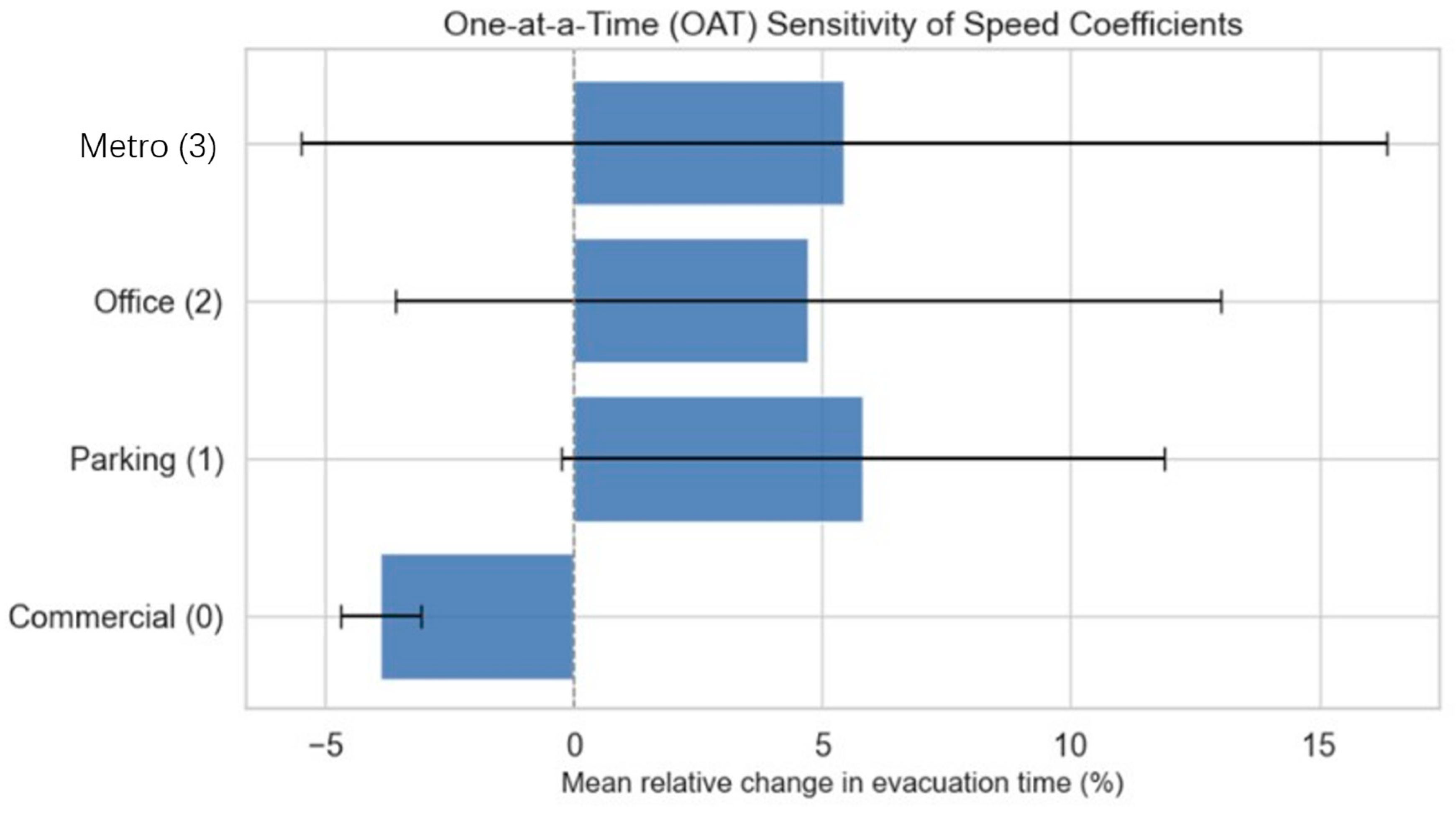
To ensure the robustness and credibility of the evacuation time estimations produced by the ABM, a comprehensive sensitivity analysis of the agent speed coefficients was conducted. This analysis examined the effects of parameter variation on simulation outcomes and confirmed that evacuation time is relatively insensitive to moderate changes (±10%) in walking speed assumptions across different functional zones. Specifically, the agent speed coefficients adopted in this study—0.9 for underground commercial areas, 0.7 for parking, 0.8 for offices, and 1.1 for metro zones—were determined based on empirical observations and literature benchmarks [,]. In addition, the adopted pedestrian speed parameters were cross-checked against widely cited empirical sources and engineering handbooks. Weidmann’s synthesis reports an average free walking speed of about 1.34 m/s for adults in uncongested conditions, with typical ranges around 1.2–1.5 m/s depending on context [], while the SFPE Handbook recommends nominal design values near ~1.2 m/s for unimpeded movement in evacuation analyses []. These benchmarks are consistent with the base speeds and zone-specific coefficients used in our ABM. Together with the sensitivity analysis (Appendix A), they strengthen the empirical grounding and reliability of the evacuation simulation. The results indicated that even under the extreme variation of ±20%, the ranking and relative differences in evacuation times among layout schemes remained stable, suggesting that the model outcomes are primarily driven by spatial configuration rather than specific parameter values. Detailed sensitivity results and validation analyses are provided in Appendix A. Hence, the ABM can be considered robust, and spatial layout remains the dominant factor affecting evacuation performance.
2.3.3. Constrains
To ensure that the optimization results are practically implementable and consistent with realistic planning principles, this study establishes the following constraints during the modeling process. These constraints regulate the permissible zones for modification in both aboveground and underground spaces, the allowable ranges for functional type transitions, and structural limitations [,]:
First, for underground space units designated as metro functions (function type 3), optimization adjustments are only allowed in the peripheral areas. Specifically, if a unit is originally defined as a metro function in the underground land-use data and its Manhattan distance to the nearest non-metro unit exceeds 2 grid cells, it is considered a core structural unit and remains fixed during the optimization process. This constraint is designed to protect the safety boundaries of the main metro station structure and entrance/exit systems.
Second, areas with an underground development intensity of three levels (UIi = 3) are excluded from the optimization scope. Due to their complex spatial structure and special construction conditions, these areas are typically planned as independent specialized projects and are not suitable for mixed functional configurations with general uses.
Third, aboveground road areas (LUi = 0) are designated as non-optimizable zones, and conversion to other uses is prohibited. This constraint ensures the continuity and accessibility of the surface transportation system, preventing disruption to the above-ground traffic network.
Fourth, during the decoding process of the optimization variables, underground units originally designated as non-metro functions (such as commercial, office, or parking) are not allowed to be reassigned as metro functions. This constraint prevents unreasonable functional conversions in the planning logic.
These hard constraints are strictly enforced during each solution evaluation. Any infeasible configuration is immediately corrected at the variable decoding stage, ensuring that the algorithm’s search is always conducted within a feasible solution space. Through these constraints, this study guarantees that all generated solutions maintain fundamental engineering feasibility and planning rationality.
2.3.4. NSGA-II Computational Process
NSGA-II is a classical multi-objective optimization method that simulates the process of natural evolution to identify a set of optimal trade-off solutions across multiple conflicting objectives. In this study, NSGA-II is employed to optimize the functional configuration of both above-ground and underground spaces surrounding metro stations, aiming to achieve a globally balanced layout in terms of evacuation safety, functional conflict minimization, development benefits, and functional proportion structure.
The algorithm begins by generating an initial population of layout schemes, with each scheme representing a complete configuration of spatial functions above and below ground. Each scheme is treated as an individual, which is evaluated using four objective functions. Among these, the evacuation time is dynamically calculated through an integrated agent-based simulation model. The other three objectives, namely functional conflict level, development benefit, and structural deviation, are directly derived from the spatial configuration data.
Following the evaluation phase, NSGA-II performs non-dominated sorting on all candidate solutions. This sorting is based on the concept of Pareto optimality: a solution is considered non-dominated if it is not simultaneously worse than any other solution across all objectives. The algorithm first identifies all non-dominated solutions and assigns them to the first front. The remaining solutions are then iteratively filtered to form the second front, third front, and so on, resulting in a hierarchical structure of solutions.
To maintain diversity in the solution set, NSGA-II introduces the concept of crowding distance, which quantifies the difference in objective values between neighboring solutions. Solutions located in less crowded regions of the objective space are prioritized for retention, thereby promoting a well-distributed Pareto front.
During the iterative process, the algorithm selects solutions from the higher-ranked and more widely distributed fronts and generates new candidate solutions through crossover and mutation operations. These new solutions are then subjected to the next round of objective function evaluation and sorting, gradually converging toward the optimal solution space across multiple objectives.
Ultimately, NSGA-II produces a set of non-dominated solutions known as the Pareto front. This solution set represents trade-offs that cannot be further improved in all objectives simultaneously. Each solution performs optimally in at least one objective while maintaining acceptable performance in others. The Pareto front does not indicate a single optimal solution but provides a structured and diverse set of alternatives to support informed decision-making in the subsequent planning stages.
The hyperparameter configuration adopted in this study, as summarized in Table 4, aligns with established practices in evolutionary optimization For instance, Hazbei et al. [] and Rafati et al. [] employed relatively moderate population sizes (20–50), crossover probabilities around 0.9, and mutation rates of approximately 0.2 in design problems with relatively small decision spaces (5–10 variables). In contrast, the optimization problem in this study involves a theoretical search space of 4487, featuring extremely high dimensionality and discrete combinatorial characteristics. To address this complexity, we adopted a larger population size (100) and a lower bitwise mutation probability (1/n), which is a standard strategy for high-dimensional evolutionary optimization problems.
Table 4.
NSGA-II Hyperparameter Settings Used in This Study.
To enhance search capability while preserving chromosome integrity, the Half Uniform Crossover (HUX) operator was employed, with the crossover probability set to 1.0 to maximize recombination efficiency. The optimization results confirm that this configuration provides adequate exploration capacity to identify well-performing solutions. As shown in Figure 3, the resulting Pareto front exhibits clear trade-offs among the four objectives and demonstrates good diversity and distribution balance across the objective dimensions. Notably, the development-scale deviation dimension shows no convergence bias, indicating that the optimization process achieved a comprehensive balance among conflicting objectives. Therefore, despite the large search space and high computational cost, the chosen hyperparameter configuration and search strategy enabled effective convergence and diverse solution coverage within the available computational budget, yielding satisfactory optimization performance and practical feasibility.
Figure 3.
Pareto Front Solutions.
2.4. TOPSIS-Based Solution Selection
Within the Pareto front generated by NSGA-II, each solution exhibits different levels of performance across multiple objectives. To identify a single recommended solution with the best overall performance, this study adopts TOPSIS, a widely used multi-criteria decision-making method, to rank and score the candidate solutions [].
The core concept of TOPSIS is to map all evaluated solutions into a multi-dimensional objective space, where two reference points are constructed: an ideal solution, composed of the best value for each objective, and a negative ideal solution, composed of the worst value for each objective. Each actual solution is then assessed based on its Euclidean distance from both the ideal and negative ideal solutions. The relative closeness of each solution to the ideal point determines its overall ranking, reflecting its comprehensive superiority in the objective space.
Specifically, for each Pareto-optimal solution generated by NSGA-II, the four objective values are first normalized. Then, the Euclidean distance between the solution and the ideal solution is calculated and denoted as , while the distance to the negative ideal solution is denoted as . Based on these distances, the relative closeness score for each solution is computed as Formula (3):
where represents the TOPSIS score for the solution. A higher score indicates closer proximity to the ideal solution and thus better overall performance.
In this study, all four objectives, including evacuation time (), conflict degree (), development benefit (), and structural deviation (), are formulated as minimization problems, meaning that lower values are preferred. Therefore, the ideal solution is composed of the minimum values of each objective across the entire solution set. After scoring, each Pareto solution is assigned a corresponding value and ranked from highest to lowest. The solution with the highest score is selected as the recommended solution. The corresponding spatial layout is adopted as the final optimization result for both underground and above-ground spaces. The TOPSIS method preserves the original multi-objective structure while simplifying the trade-off process into a single scalar score, offering a transparent and interpretable decision-support tool for navigating complex multi-objective solution sets.
3. Results
3.1. Study Area Analysis
Qingdaobei Railway Station, located in the Licang District of Qingdao, Shandong Province, is situated approximately 14 km north of the city center. Opened on 10 January 2014, the station serves as a major transportation hub in Qingdao, providing access to multiple rail modes including high-speed, conventional, and metro lines. The station complex covers about 68,000 m2 and includes several underground levels connected directly to the metro system. Its location is strategically significant: positioned on reclaimed land near Jiaozhou Bay, roughly 500 m from the coastline, it integrates regional rail connectivity with urban transit accessibility.
We selected this station area for analysis because it presents a typical complex urban–underground interface, with dense surface transport, multiple metro connections, and significant underground spatial potential, making it an ideal testbed for optimizing underground space under the TOD paradigm.
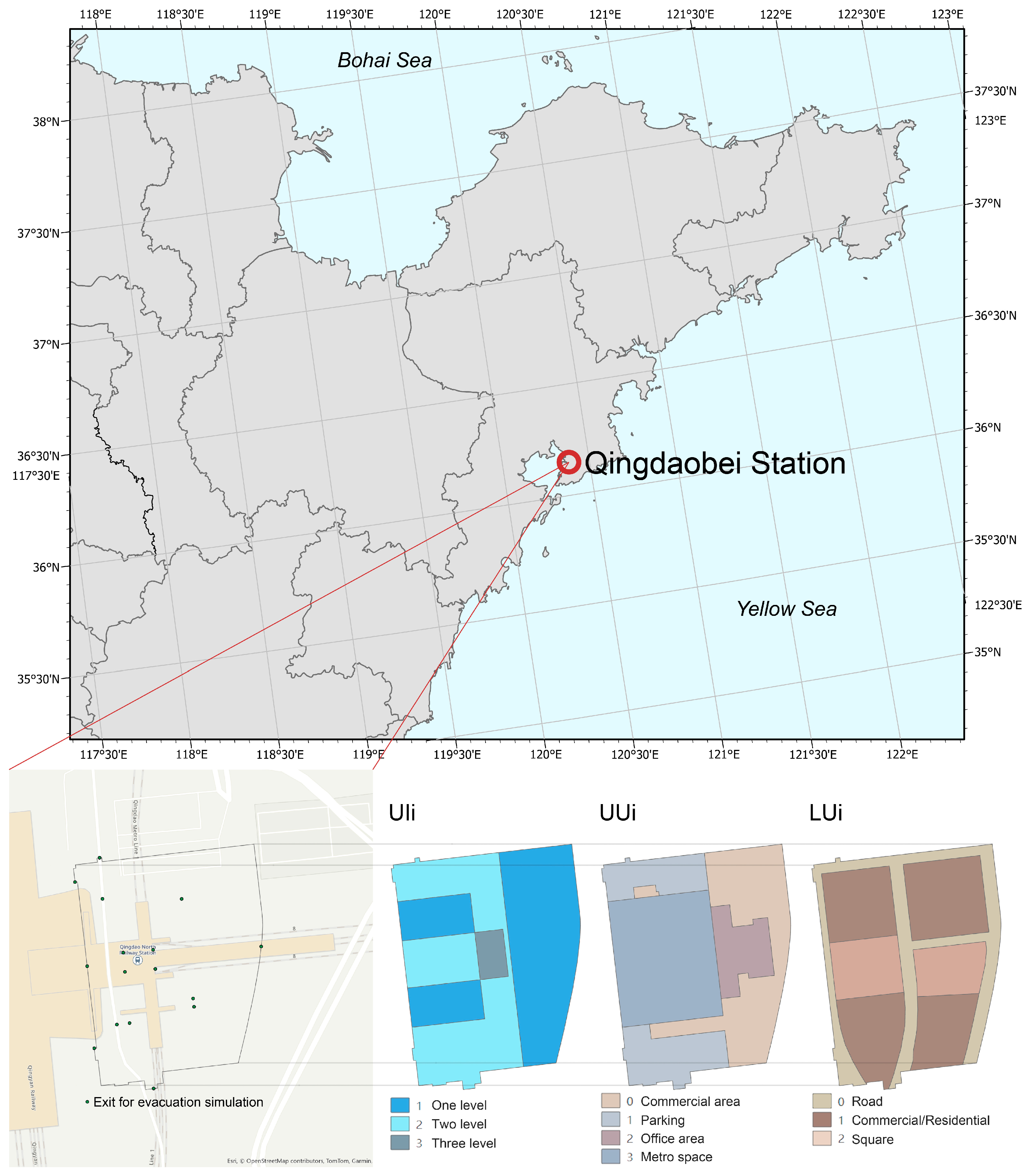
As a critical multimodal transportation hub in Qingdao, Qingdaobei Railway Station is critical for both intra-city and inter-city travel. Figure 4 illustrates the layout of the study area, including underground development intensity (UIi), underground land-use types (UUi), surface land use (LUi), and the distribution of station entrances and exits. The existing underground infrastructure displays partial characteristics of functional agglomeration, with commercial, office, and parking functions concentrated around the metro station. While this clustering leverages the hub’s agglomeration potential, the current spatial configuration presents opportunities for improvement in terms of functional integration and pedestrian connectivity, falling short of the comprehensive, mixed-use principles emphasized by the TOD model.
Figure 4.
Study Area Map.
The underground layout demonstrates a clear functional concentration pattern, particularly with office spaces densely located near the metro station core. This proximity facilitates convenient commuting for office users but leads to localized crowding during peak hours, increasing pedestrian density and evacuation pressure. While such concentration enhances productivity and land-use efficiency, it lacks integration with surrounding functional zones, resulting in limited spatial flexibility and underutilized synergies.
Parking facilities are predominantly located on the second and third underground levels, yet lack direct linkages to metro entrances. Although this configuration helps alleviate surface traffic loads, the relatively independent circulation paths between parking areas and transfer points result in inconvenient pedestrian transfers for passengers moving between parking lots and metro entrances. This issue is especially pronounced during peak hours, where the intermingling of parking and commercial pedestrian flows further complicates crowd management and wayfinding.
Commercial functions are primarily clustered near metro station entrances and adjacent areas, forming strong localized commercial activity. However, this spatial clustering remains relatively disconnected from parking infrastructure, leading to a low degree of integration between transportation and commercial services. Although the commercial layout succeeds in attracting passenger traffic, it also overlaps with critical transfer corridors during rush hours, increasing pedestrian congestion and indicating inefficiencies in the mixed-use design.
The above-ground spatial layout exhibits certain limitations in functional diversity, particularly due to the lack of organic integration between roads and plazas, which affects the continuity of pedestrian spaces. While plazas serve as hubs for pedestrian aggregation and dispersal, their weak spatial linkage with commercial zones diminishes their agglomeration potential. Moreover, the road network is predominantly linear and lacks a multi-nodal pedestrian circulation system, restricting seamless movement across different urban functions.
Overall, the Qingdaobei Railway Station area has achieved a certain degree of functional agglomeration and spatial utilization under the current development pattern. However, there remains significant room for improvement in terms of functional integration, spatial connectivity, and crowd management. In particular, during peak periods, the relatively concentrated layout of commercial, office, and parking functions leads to localized pedestrian congestion, which imposes limitations on evacuation efficiency. The connectivity between above-ground and underground spaces also requires enhancement, with opportunities to improve the completeness of the pedestrian network and the degree of spatial mixing. Through rational optimization of layout and functional allocation, it is expected that the spatial intensification and transportation convenience characteristics advocated by the TOD model can be better realized.
3.2. NSGA-II Optimization Results and TOPSIS Selection
To address the underground infrastructure layout optimization problem at Qingdaobei Railway Station, the NSGA-II algorithm was employed with four objective functions: minimization of evacuation time (), minimization of functional conflicts (), maximization of development benefits (), and minimization of deviation from the target development scale (). By resolving these conflicting objectives, NSGA-II generated a set of Pareto-optimal solutions that reflect the inherent trade-offs among competing infrastructure performance criteria. Figure 3 illustrates the relationships among the objective functions, highlighting the mutual constraints between functional conflict, development efficiency, and structural conformity.
A total of 5000 optimization iterations were conducted, with 100 candidate solutions evaluated per generation. This parameter configuration was selected to ensure sufficient exploration of the solution space while maintaining computational efficiency. The rationale and characteristics of the search space are elaborated below.
First, the population size of 100 and the number of generations (50, resulting in 5000 candidate evaluations) were selected based on a balance between computational feasibility and optimization quality. Each evaluation involves computing four objective functions, one of which includes an agent-based evacuation simulation that is computationally expensive. Preliminary trials showed that smaller population sizes (e.g., 20 or 50) led to reduced diversity in the Pareto front, while larger sizes (e.g., over 200) incurred excessive computational cost with only marginal improvements in solution quality.
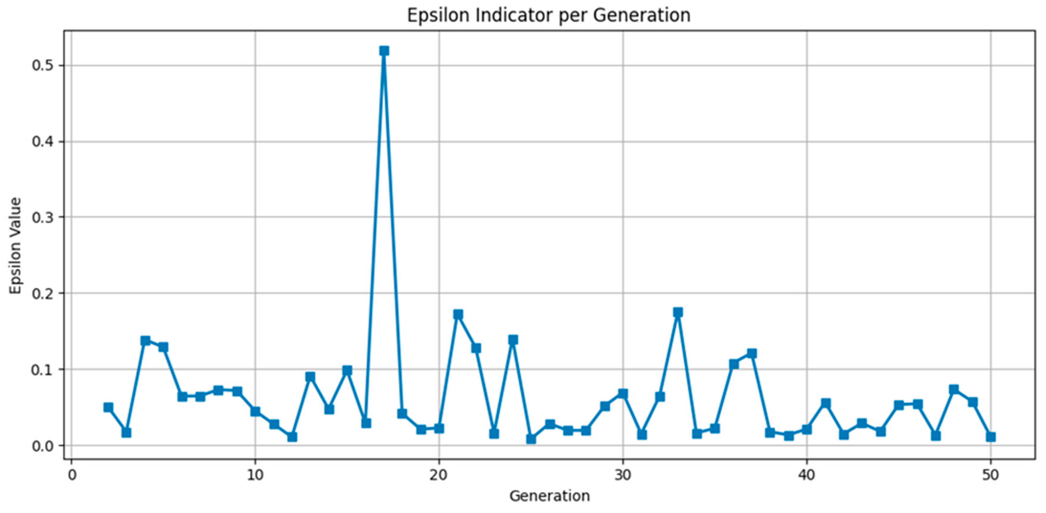
To further validate the sufficiency of these parameter settings, we analyzed the convergence behavior of the algorithm over 50 generations. We have added a new Appendix B, which presents the optimization process in detail. As shown in Figure A3 and Figure A4, the number of non-dominated solutions increased steadily during the early generations, reaching the maximum value of 100 by generation 25 and remaining consistently high thereafter. Concurrently, the epsilon indicator, which measures the improvement of the Pareto front, exhibited a generally decreasing trend despite some fluctuations, and stabilized below 0.02 in the later generations. These patterns confirm that the chosen population size and iteration count enabled the algorithm to achieve both convergence and solution diversity efficiently.
Second, regarding the search space: the optimization problem includes a total of 487 decision units (278 underground and 209 above-ground), each encoded using two binary digits to represent one of four functional categories. This results in a theoretical search space of 4487 possible configurations.
However, this theoretical number does not account for the strict domain-specific constraints integrated into the model. For instance, functional proportions (e.g., commercial, office, parking) are preserved through a repair mechanism after decoding, while certain land use types such as metro and roads are fixed or only partially modifiable. These constraints dramatically reduce the effective size of the feasible solution space. While the exact size of this constrained subspace is difficult to quantify analytically, it is orders of magnitude smaller than the unconstrained theoretical total. The NSGA-II algorithm, combined with problem-specific operators and repair strategies, effectively concentrates the search within this feasible region, allowing for efficient exploration despite the sparsity of sampling in the full space.
The Pareto front gradually expanded and converged over time. During the initial optimization stages (generations 1 to 10), the number of non-dominated solutions increased rapidly from 25 to 75. As the algorithm progressed, the solution set stabilized around 100 non-dominated configurations, with continuous improvements in convergence. Notably, alternating occurrences of ideal and nadir solutions across certain generations indicated an ongoing update process shaped by evolving trade-offs among multiple infrastructure planning objectives.
The three-dimensional scatter plot in Figure 3 reveals a distinct negative correlation between development benefit () and both evacuation time () and functional conflict (). When development benefit is maximized, evacuation time and development conflict tend to increase, reflecting increased pedestrian density and reduced safety margins in high-intensity development zones. These patterns underscore the need for a comprehensive balance between development intensity, spatial safety, and functional rationality in underground infrastructure systems.
Throughout the optimization process, NSGA-II approached the Pareto front via fast non-dominated sorting and diversity-preserving mechanisms. The final solution set highlights a significant trade-off between development benefit () and conflict level (). In regions of high development intensity, evacuation time increases sharply, while the structural deviation () remains relatively stable, suggesting the importance of adjusting functional distribution to reconcile spatial efficiency with operational safety.
To identify the most balanced infrastructure configuration, the TOPSIS method was applied to the Pareto front (Figure 3). By computing the relative closeness of each solution to the ideal and anti-ideal solutions, TOPSIS evaluated overall performance across all four objectives and selected the highest-ranking scheme as the recommended layout. The optimal solution had objective values of = [737, 60,450, −20,050, 1.294], demonstrating balanced performance across evacuation efficiency, conflict minimization, development return, and scale conformity.
A comparative analysis of the NSGA-II and TOPSIS results indicated that through optimized redistribution of commercial, office, and parking functions, pedestrian congestion was significantly alleviated. Specifically, office space clustering and functional conflict between parking facilities and metro station entrances were reduced. In addition to improved space utilization, the refined layout of transfer corridors enhanced pedestrian accessibility and evacuation capability. These findings demonstrate the practical effectiveness and applicability of the integrated NSGA-II and TOPSIS framework for optimizing underground infrastructure configurations in high-density, transit-oriented environments such as Qingdaobei Railway Station.
3.3. Implications for Practice
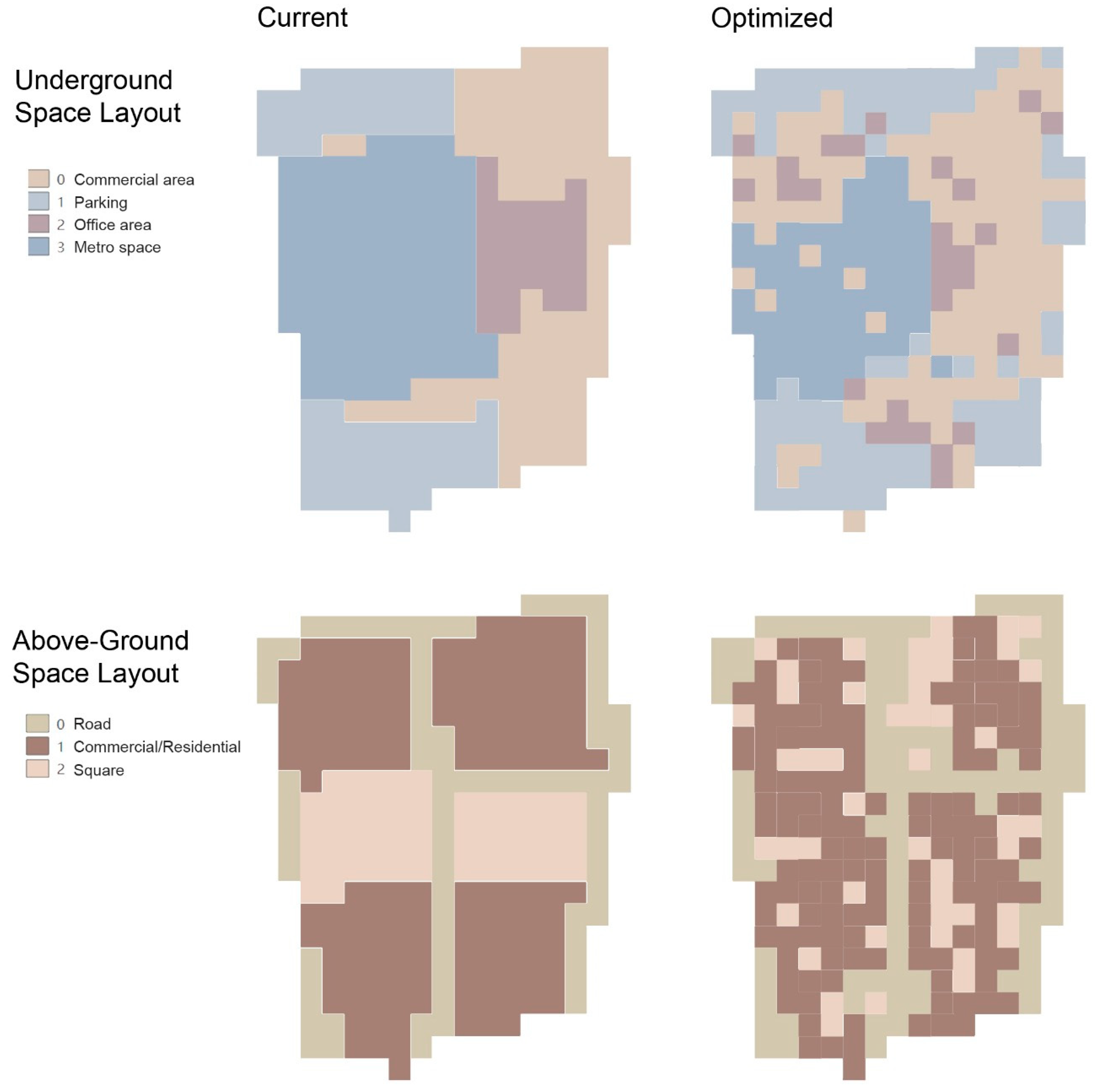
Building upon the optimization results derived from NSGA-II and TOPSIS, the findings of this study provide several practical implications for underground space planning under the TOD model. The final optimized spatial layout reflects a well-balanced trade-off among evacuation efficiency, development benefits, and spatial utilization, offering a useful reference for improving design coordination and spatial integration in similar urban transit hubs. Figure 5 presents a comparative analysis of the existing and optimized underground layouts, clearly illustrating the enhancements in infrastructure organization and pedestrian evacuation capacity achieved through the optimization process.
Figure 5.
Comparison of Current and Optimized Layout.
From a practical perspective, the optimized scheme demonstrates substantial improvements in both functional allocation and spatial configuration of underground infrastructure:
First, the optimized distribution of office space demonstrates how a more balanced spatial arrangement can enhance both safety and adaptability in underground environments. In the existing layout, office functions are overly concentrated around the metro station core, resulting in elevated pedestrian density and reduced evacuation efficiency during peak hours. The revised configuration disperses office areas across multiple nodes, effectively lowering crowd concentration and reducing evacuation time by about 15%. This outcome suggests that decentralizing high-intensity functional zones can substantially improve spatial flexibility and operational resilience within transit-oriented underground systems.
Second, the reorganization of parking infrastructure illustrates the value of closer functional integration with transit facilities. In the current condition, dispersed parking locations and fragmented pedestrian routes hinder efficient movement between parking areas and metro entrances. The optimized layout strategically co-locates parking facilities with major access points, thereby shortening walking distances, improving transfer convenience, and reducing conflicts between vehicular and pedestrian flows. This configuration proves especially effective during peak periods, enhancing the operational efficiency and user experience of the overall transport infrastructure.
Third, the commercial infrastructure demonstrates a higher degree of mixed-use integration. While the existing layout features clustered but disjointed commercial areas with limited synergy with transit circulation, the optimized design strategically positions commercial zones between the metro station and parking areas, forming a hybrid commercial-transportation infrastructure system. This configuration improves accessibility, enhances commercial vibrancy, and mitigates congestion risks associated with overlapping pedestrian and commercial flows.
In terms of above-ground infrastructure, the optimized layout demonstrates a more coherent and functionally integrated spatial organization. The existing configuration shows limited pedestrian continuity due to weak linkages between roads and plazas, which constrain overall accessibility. The revised scheme reorganizes these elements into multifunctional, mixed-use open spaces, improving pedestrian flow and enhancing the spatial connection between above-ground and underground systems. Importantly, the strengthened linkage between commercial and residential zones and surrounding plazas facilitates more natural pedestrian movement and alleviates congestion in high-density areas. These results suggest that promoting surface–subsurface integration and enhancing spatial continuity can serve as effective strategies for improving walkability and urban experience in similar transit-oriented environments.
Consistent with the tendencies observed in the objective function values, the optimized scheme yields measurable improvements across key performance indicators, offering clear implications for practical design and management.
- Evacuation Time (): Through the decentralization of office functions and the rational reconfiguration of entrances and exits, evacuation time is reduced from over 900 s in the current layout to approximately 737 s—an improvement exceeding 15%. This highlights how spatial redistribution can directly enhance pedestrian safety and evacuation efficiency in high-density hubs.
- Development Conflict (): Representing the overall degree of functional incompatibility among adjacent spatial units, this indicator decreased from 68,000 to 60,450. The reduction, achieved through coordinated planning of parking and commercial areas, indicates stronger functional synergy and a more coherent spatial structure—an outcome that underscores the value of integrated land-use strategies in practice.
- Development Benefit (): Increased to −20,050, reflecting a tangible improvement in infrastructure efficiency arising from the coordinated integration of commercial and transport functions. This result demonstrates how multi-objective optimization can help planners identify configurations that simultaneously strengthen operational and economic performance.
- Development Scale Deviation (): Stabilized at 1.29 after appropriately adjusting the proportions of commercial, office, and parking functions. This alignment with the target structure reveals a more balanced and context-responsive functional composition—offering a reference for practitioners seeking to harmonize spatial allocation with planning goals in complex underground systems.
Figure 5 provides a clear visualization of these improvements by comparing the spatial layouts before and after optimization. The optimized underground configuration demonstrates greater flexibility, particularly in the coordination between office and commercial areas. The reallocation of parking facilities enhances alignment with metro station entrances, effectively addressing the disconnection issues identified in the baseline layout. At the surface level, improved integration between roads and plazas strengthens walkability and accessibility, contributing to a more sustainable and user-oriented infrastructure network. The strengthened cohesion between surface and subsurface systems further embodies the essential planning principles of the TOD model, emphasizing connectivity, functional harmony, and human-centered design.
From a practical perspective, the NSGA-II and TOPSIS-based optimization framework offers valuable insights into improving both spatial efficiency and infrastructure resilience within the underground development surrounding Qingdaobei Railway Station. The optimized configuration serves as an example of how quantitative, data-supported analysis can inform the refinement of infrastructure layouts, enhance operational coordination, and support decision-making in complex transit-oriented environments. The outcomes provide a methodological reference for planners and engineers seeking to align underground space development with broader objectives of sustainable urban growth under the TOD framework.
At the same time, certain methodological constraints should be acknowledged. The solutions generated through NSGA-II and TOPSIS represent model-based results that simplify real-world complexities into quantifiable objectives and constraints. This abstraction may not fully encompass practical issues such as compliance with building codes, engineering feasibility, or coordination among multiple administrative entities. Consequently, the optimized scheme should be regarded as a heuristic planning tool intended to guide professional judgment through scientific evidence rather than a prescriptive blueprint. In real-world implementation, it remains essential to calibrate and refine the proposed layout according to site-specific conditions, regulatory frameworks, and socio-economic contexts. Through such iterative adjustment, the insights drawn from optimization can be effectively translated into feasible and context-appropriate design practices, ensuring that infrastructure development remains both sustainable and grounded in reality.
4. Discussion
4.1. Advantages and Limitations of the Method
The underground spatial layout optimization approach combining NSGA-II and TOPSIS yielded favorable outcomes in this study, notably enhancing evacuation efficiency, spatial utilization, and overall development benefits []. By integrating multi-objective optimization techniques with multi-criteria decision-making frameworks, this method systematically accounts for the multidimensional factors and complex interdependencies characteristic of underground spatial systems. The following discussion outlines its key advantages and limitations.
Firstly, the automated optimization capability of the proposed method enables the efficient generation of multiple alternative spatial configurations, significantly improving the scientific rigor and objectivity of the infrastructure planning process compared to conventional experience-based approaches []. In the context of underground infrastructure layout, decisions regarding functional distribution and development intensity often involve competing objectives. The NSGA-II algorithm, through non-dominated sorting and crowding distance mechanisms, facilitates a rapid exploration of the solution space to identify a Pareto-optimal set, thereby reducing subjective biases typically associated with manual decision-making [].
Secondly, the TOPSIS method, employed as a post-optimization selection tool, facilitates the identification of the optimal infrastructure planning scheme from a set of multi-objective trade-off solutions []. By calculating the relative closeness to ideal and negative-ideal solutions, TOPSIS simplifies complex multi-objective decision-making into a single comprehensive evaluation metric, enabling planners to efficiently recognize the layout scheme with the best overall performance []. This approach is particularly effective for ranking and balancing alternatives within diverse solution sets, thereby strengthening the scientific rigor and transparency of infrastructure planning decisions.
Moreover, the methodological framework developed in this study exhibits strong generalizability and can be applied to underground infrastructure planning in other urban rail transit hub areas []. By modifying the objective functions and constraint parameters, the model can be adapted to diverse spatial optimization tasks across varying scales and development intensities, thereby improving the ability of infrastructure systems to cope with turbulent, uncertain and increasingly complex environments and enhancing the resilience of infrastructure systems [].
Despite the robust theoretical strengths exhibited by the proposed optimization method, several limitations persist in its practical implementation.
Firstly, the selection of objective functions and the assignment of corresponding weights can exert a substantial influence on the optimization outcomes []. This study primarily emphasizes objectives such as evacuation time, development conflicts, comprehensive development benefits, and functional scale—all closely aligned with transit-oriented underground infrastructure planning. However, real-world planning scenarios often demand broader considerations. Critical dimensions such as environmental sustainability, spatial quality, and social equity remain unaddressed in the current framework. Future research should expand the objective function system to integrate these factors, enabling more holistic, resilient, and sustainability-oriented optimization of underground infrastructure layouts across diverse urban contexts [].
Moreover, underground space development entails considerable energy consumption for ventilation, lighting, and climate regulation, as well as embodied carbon arising from excavation and concrete-intensive construction processes [,]. Future extensions of this research should therefore integrate life-cycle assessment (LCA)–based indicators to evaluate carbon footprints, operational energy, and resource efficiency, enabling a more balanced trade-off between spatial performance and environmental impact.
Socially, ensuring equitable accessibility, comfort, and safety for all users, including people with reduced mobility [], is an essential component of human-centered TOD planning. Introducing social equity indicators such as accessibility weighting or universal design compliance would enable the optimization model to better represent inclusiveness and spatial justice. Embedding these environmental and social objectives into future models would transform the framework from a purely efficiency-driven tool into a holistic and sustainability-aligned decision-support system consistent with the principles of the United Nations Sustainable Development Goals (SDGs).
Another limitation concerns the flexibility and precision of constraint conditions present limitations in practical implementation []. In the optimization process, constraints such as the protection of core metro station structures, restrictions on the number of underground levels, and the fixation of road land use were imposed to ensure the feasibility and safety of the proposed schemes. However, in actual project execution, the diversity of spatial forms and development policies may render some of these constraints inapplicable. Therefore, a key direction for future research is to enhance the adaptability of constraint conditions while maintaining the effectiveness of optimization outcomes.
A further limitation is that the optimization model employed in this study adopts a static view of spatial layout, without accounting for the temporal dynamics of land use and pedestrian flow []. With the increasing trend of functional integration under the TOD model, the utilization patterns of underground spaces and the organization of pedestrian movement may vary significantly by time of day and season []. Future work should incorporate dynamic land use patterns and time-series behavioral data into the optimization framework, thereby enhancing its spatiotemporal flexibility and enabling more responsive, infrastructure-resilient, and sustainability-oriented spatial planning in evolving urban environments.
Even so, the current model remains limited by its static representation of spatial configurations, which does not reflect the temporal variability of pedestrian movement or land use change. In reality, pedestrian flow intensity varies significantly throughout the day, between weekdays and weekends, and across different seasons. Similarly, the functional composition of transit-oriented hubs evolves as new facilities appear and usage patterns shift over time. Future research could address this limitation by incorporating time-dependent pedestrian mobility data, such as hourly or daily records obtained from smart card systems or in situ sensors. In addition, dynamic land use transition models can be introduced to simulate how spatial functions change over time within the optimization process. Integrating these temporal elements would allow the framework to evolve into a spatiotemporal optimization model that better supports adaptive and realistic urban planning decisions [,].
Overall, the underground spatial layout optimization approach based on NSGA-II and TOPSIS exhibits notable strengths in planning rationality and computational efficiency, providing relatively objective and structured decision support for urban planners. Nevertheless, its practical applicability remains constrained by limitations in the selection of objective functions and the rigidity of constraint conditions []. Future refinements could focus on the incorporation of dynamic land use patterns, the calibration of algorithmic parameters, and the construction of a more comprehensive and sustainability-informed system of objectives, thereby advancing the method’s practical utility, contextual adaptability, and level of computational intelligence.
4.2. Implications for Planning Practice
The underground space optimization model developed in this study, which integrates NSGA-II with TOPSIS, demonstrated promising performance when applied to the Qingdaobei Railway Station area. By optimizing the spatial arrangement of office, commercial, parking, and transfer functions, the model significantly enhanced both space utilization efficiency and evacuation safety. These findings provide practical guidance for the development of underground spaces within the framework of the TOD model, particularly in transit-oriented urban core zones [].
The translation of model outputs into planning actions requires specifying how optimized spatial adjustments can be operationalized through design and management measures. The following recommendations elaborate on the actionable strategies implied by the optimization results, offering concrete pathways for planners to implement integrated, safe, and efficient underground space development.
Firstly, functional integration is one of the critical factors in underground space development within the TOD framework []. The optimized scheme in this study embeds commercial facilities into transit nodes, enabling a seamless combination of commercial and transportation functions. This not only alleviates pedestrian congestion in high-traffic areas but also highlights the importance of mixed-use development in improving spatial efficiency and accessibility. Therefore, planning practice should prioritize the integrated design of commercial spaces, transit infrastructure, and pedestrian systems, especially in and around core metro station areas, by rationally allocating multiple functional components []. Specifically, the optimized layout suggests embedding commercial corridors directly along pedestrian transfer routes and between metro concourses and parking access points. In practice, planners can adopt a multi-layer functional zoning approach—placing daily-use retail and services within 0–50 m of station exits, while reserving larger-scale offices and dining spaces for peripheral areas. This configuration shortens travel paths, enhances commercial exposure, and prevents congestion at single nodes. Moreover, developers should enforce shared ventilation, signage, and circulation standards between commercial and transport facilities to ensure a continuous spatial experience and efficient energy management.
Secondly, transportation convenience is a critical factor in determining the rationality of underground spatial layouts []. The findings of this study suggest that locating parking facilities near metro entrances enhances park-and-ride efficiency and mitigates conflicts between pedestrian and vehicular flows [,]. In practical planning, traffic flow analysis should be employed to rationally position parking areas and pedestrian pathways, enhancing the accessibility and connectivity of entry and exit points. This helps avoid the fragmentation of parking and pedestrian zones and improves the overall transfer experience. The optimization also highlights that co-locating parking entrances within 50 m of major metro exits minimizes horizontal travel and reduces cross-flow between vehicles and pedestrians. To implement this, management authorities could adopt a hierarchical access system: separating inbound and outbound vehicular routes and linking them to pedestrian corridors through short, well-lit passages. Additionally, real-time traffic and occupancy monitoring should be integrated into smart-parking systems to dynamically guide users and alleviate local congestion during peak hours.
Thirdly, spatial flexibility is vital for accommodating fluctuations in pedestrian density and addressing unexpected events []. In the optimized layout, a balanced distribution of office spaces helps prevent congestion at individual nodes during peak hours. Future underground space development should prioritize adaptable layout strategies by introducing multi-node configurations and flexible spatial transformations [,]. This design approach supports efficient pedestrian movement during high-demand periods and contributes to safer and more responsive evacuation in emergency scenarios. Based on the decentralized office layout derived from optimization, planners can introduce modular floor-plate configurations and reconfigurable partitions to allow rapid adaptation between office, retail, and public uses. In emergency-prone or high-density hubs, establishing dual-direction evacuation corridors and reserving multi-functional buffer zones (e.g., plazas or lobbies) as temporary gathering spaces can further enhance safety and resilience.
In addition, the optimization method based on NSGA-II and TOPSIS employed in this study demonstrates strong generalizability [] and can serve as a reference for underground space planning in other urban rail transit hub areas. The applicability of this method to other city cases can be analyzed as follows:
First, the NSGA-II algorithm allows for a flexible definition of objective functions and constraints, making it adaptable to the specific conditions of different cities []. For instance, in cities with a vibrant commercial environment, development benefits can be prioritized as the primary optimization goal, whereas in areas with severe traffic congestion, evacuation time can be emphasized as a core indicator. This flexibility enables the method to accommodate diverse urban development needs and spatial structural characteristics, supporting sustainable infrastructure planning tailored to local contexts.
Second, the TOPSIS method demonstrates high reliability in selecting optimal solutions from a multi-objective solution set []. In diverse urban contexts, multiple solutions within the Pareto front may excel in different objective criteria; TOPSIS efficiently identifies the optimal solution through a comprehensive scoring mechanism. This decision-making approach is applicable to a wide range of underground space layout problems characterized by multi-objective trade-offs, providing a rapid and balanced recommendation for planning decisions.
Furthermore, this method can be integrated with other urban planning models to enhance its practical applicability [,]. For instance, in urban renewal or comprehensive infrastructure development projects, TOPSIS can be combined with GIS-based spatial analysis to develop more detailed multi-objective functions. By incorporating dynamic pedestrian flow forecasting and land-use change trends, the approach can better accommodate the long-term, sustainable evolution of urban infrastructure systems. This integration provides more precise guidance for adaptive underground space layout planning aligned with sustainable urban development principles.
Finally, the evacuation time calculation approach based on ABM also demonstrates strong transferability []. In large and high-density transportation hubs, such as Beijingnan Railway Station and Shanghai Hongqiao Railway Station, model parameters can be adjusted to reflect local travel characteristics and passenger transfer flows. This enables more precise simulation of evacuation processes, therebyenhancing the reliability of planning outcomes in complex transit infrastructure systems.
In summary, the NSGA-II and TOPSIS-based optimization approach proposed in this study exhibits strong applicability to the development of underground spaces in urban rail transit hub areas across different cities []. By flexibly adjusting model parameters and objective functions according to local planning needs, this method can effectively support the scientific optimization of multifunctional mixed-use layouts []. It thus provides robust technical support for improving the spatial efficiency and accessibility of transit-oriented infrastructure while aligning with long-term sustainable urban development goals. Collectively, these actionable guidelines illustrate how quantitative optimization results can be transformed into practical spatial planning and management decisions. The identified spatial adjustments—such as decentralizing high-density office zones, embedding commercial corridors along transit axes, and co-locating parking and transfer facilities—demonstrate a direct translation from model-based outcomes to implementable design measures. This “model-to-practice” linkage provides a replicable workflow for integrating computational optimization into real-world underground space planning under the TOD framework.
5. Conclusions
This study proposes an intelligent optimization model for underground space layout within the TOD framework. In contrast to conventional approaches that only rely on algorithmic optimization and static criteria, this research innovatively embeds an ABM into the optimization process to dynamically simulate pedestrian evacuation behavior within transit hubs. Taking the Qingdaobei Railway Station area as a case study, the research emphasizes the spatial optimization of office, commercial, parking, and transfer functions closely linked to passenger mobility and transit accessibility. By combining intelligent optimization algorithms with multi-criteria decision-making techniques, the study yields the following major research outcomes:
Firstly, this study presents a novel framework that integrates ABM with NSGA-II and TOPSIS. The ABM component allows for the simulation of real-time crowd evacuation processes under varying spatial configurations, producing evacuation time as a dynamic performance indicator in the optimization loop. NSGA-II is used to generate a diverse set of non-dominated solutions balancing evacuation efficiency, development benefits, spatial synergy, and land use proportions. TOPSIS is then employed to select the most ideal solution from the Pareto front. This framework provides a more realistic and human-centered basis for spatial layout decision-making, aligning underground space planning with the spatiotemporal dynamics of transit-oriented development.
Secondly, the effectiveness of the proposed optimization model was validated through a multi-source spatial data and GIS-based analysis of the Qingdaobei Railway Station area. The results showed that the optimized scheme outperformed the existing layout in terms of evacuation efficiency, spatial utilization, and development benefits. Notably, it achieved significant improvements in balancing office space distribution, integrating parking facilities with metro entrances and exits, and promoting mixed-use commercial functions. These findings suggest that appropriate adjustments of underground functional configurations can simultaneously enhance transportation convenience, improve human mobility within the transit hub, and mitigate evacuation pressure under conditions of high pedestrian density.
Thirdly, this study proposed policy recommendations for optimizing underground space layouts in relation to the spatiotemporal dynamics of the built environment. From a functional perspective, the optimized scheme achieves the organic integration of commercial areas with transportation nodes, thereby enhancing the accessibility and vitality of commercial zones. From a spatial perspective, it directly connects parking facilities with metro entrances and exits, reducing conflicts between pedestrian and vehicular flows while supporting seamless transfers. Regarding functional mixing, the integration of surface plazas with road networks strengthens walkability, diversifies urban functions, and enriches the temporal rhythm of space use. These strategies provide a scientific basis for underground space development within the TOD model, bridging public transport planning with sustainable patterns of human mobility.
Furthermore, this study acknowledges the limitations associated with the generated optimization solutions. Due to certain abstractions and assumptions inherent in the modeling process, the optimization results require adjustments in practical engineering applications to accommodate specific environmental and policy contexts. It is also recommended that future research incorporate dynamic land-use changes and pedestrian mobility forecasting to better capture the spatiotemporal characteristics of the built environment and strengthen the linkage between underground space planning and public transport demand.
In summary, by introducing intelligent optimization methods, this study addresses the limitations of traditional underground space layout approaches and provides a scientific pathway for the sustainable development of underground spaces in urban rail transit hub areas. The proposed methodology exhibits strong generalizability and scalability, offering both theoretical support and practical guidance for integrated transport-oriented planning. Future research may further enhance the practicality and accuracy of underground space layout optimization by embedding dynamic mobility models and multi-source data, thereby deepening the connection between human movement, public transport performance, and the evolving urban built environment.
Author Contributions
Conceptualization, W.F.; Methodology, W.K.; Software, W.F.; Investigation, W.K.; Writing—original draft, W.K.; Writing—review & editing, W.F. and Y.L. All authors have read and agreed to the published version of the manuscript.
Funding
This research received no external funding.
Institutional Review Board Statement
Not applicable.
Informed Consent Statement
Not applicable.
Data Availability Statement
Data are contained within the article.
Conflicts of Interest
The authors declare no conflict of interest.
Abbreviations
The following abbreviations are used in this manuscript:
| TOD | Transit-Oriented Development |
| ABM | Agent-Based Model |
| NSGN-II | Non-dominated Sorting Genetic Algorithm II |
| TOPSIS | Technique for Order Preference by Similarity to Ideal Solution |
| USSMS | Underground Space Synchronously with Metro Stations |
| AIGA | Artificially Intervened Genetic Algorithm |
| HUX | Half Uniform Crossover |
| LCA | Life-cycle Assessment |
| SDGs | The United Nations Sustainable Development Goals |
Appendix A. Sensitivity Analysis of Agent Speed Parameters in the ABM
To validate the robustness of the agent-based evacuation model integrated into the proposed TOD-aligned underground space optimization framework, a comprehensive sensitivity analysis was conducted on the agent speed coefficients. These coefficients, applied to different functional land-use categories (commercial, parking, office, metro), modulate the effective walking speed of agents during the evacuation simulation. Given that evacuation time () is one of the key optimization objectives, understanding the influence of these parameters is essential for ensuring the credibility and applicability of the model.
Appendix A.1. Methodology
Three types of sensitivity analysis were performed:
- Global Scaling: All speed coefficients were uniformly scaled by ±10% and ±20%, simulating the effects of overall faster or slower pedestrian movement.
- One-at-a-Time (OAT): Each coefficient was independently increased and decreased by 10%, while keeping all others fixed, to assess its individual contribution to the output variance.
- Monte Carlo Simulation: 100 simulations were conducted with all four coefficients subjected to independent random perturbations sampled from a normal distribution (mean = 0, standard deviation = 5%), clipped to ensure values remain within a plausible range [0.5, 1.5].
All analyses were run using the current spatial layout, and the change in total evacuation time () was recorded relative to the baseline scenario.
Appendix A.2. Results
Table A1.
Summary of Sensitivity Results by Scenario.
Table A1.
Summary of Sensitivity Results by Scenario.
| Scenario | Min (%) | Max (%) | Mean (%) | Std Dev (%) |
|---|---|---|---|---|
| Monte Carlo (MC) | −14.69 | 27.33 | 3.5821 | 8.0805 |
| OAT–Commercial | −4.47 | −3.32 | −3.8950 | 0.8132 |
| OAT–Parking | 1.53 | 10.09 | 5.8100 | 6.0528 |
| OAT–Office | −1.15 | 10.60 | 4.7250 | 8.3085 |
| OAT–Metro | −2.30 | 13.15 | 5.4250 | 10.9248 |
| Global Scaling | −14.69 | 38.95 | 8.3780 | 19.4778 |
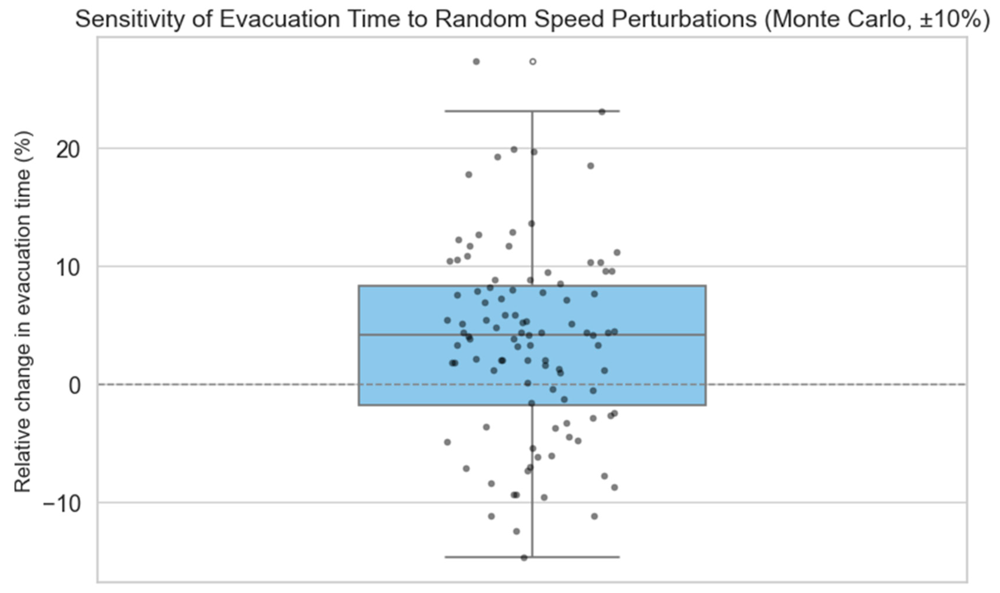
Figure A1 presents the Monte Carlo results, where most changes fall within ±10%. The distribution skews slightly positive, indicating a modest tendency toward increased evacuation time under random parameter perturbations.
Figure A1.
Distribution of Relative Change in . Percentages indicate the relative change in total evacuation time () compared to the baseline.
Figure A2 reveals that evacuation time () is most sensitive to speed variations in metro and office zones, as reflected by their relatively high standard deviations. In contrast, the commercial zone shows a consistent negative effect on with low variability, indicating that increasing walking speed in these areas tends to improve evacuation efficiency in a stable and predictable manner.
Figure A2.
One-at-a-Time Sensitivity by Functional Type.
Appendix A.3. Discussion
The sensitivity analysis confirms that the ABM component of the framework is robust to moderate variations in speed coefficient values. The Monte Carlo simulation results show that, even with random perturbations of all coefficients (mean = 0, standard deviation = 5%), the average deviation in evacuation time () remains around 3.6%, and over 90% of cases fall within a ±10% change. These results indicate good model stability under realistic uncertainty.
More importantly, the OAT experiments suggest that evacuation performance is not equally sensitive to all functional zones. Specifically, increasing the walking speed in commercial areas consistently reduces evacuation time, whereas increasing speeds in parking, office, and metro zones may lead to slightly longer on average. This result is consistent with the spatial configuration of the study area, where commercial areas are located near key station exits and serve as major pedestrian corridors.
The relatively low sensitivity of to parameter changes affirms the credibility and applicability of the ABM results in the broader optimization framework. Since the optimization process is driven by relative comparisons between layouts rather than absolute evacuation metrics, the robustness of the model underlies the reliability of the spatial optimization outcomes. Furthermore, the analysis highlights a key insight: the spatial layout of functional zones has a more pronounced impact on evacuation performance than moderate variations in pedestrian behavior parameters. This reinforces the central argument of the study—that layout optimization, especially in transit-oriented underground spaces, plays a critical role in improving both functional performance and safety outcomes.
For completeness, we reiterate that ±10% perturbations in the speed coefficients across all functional zones produced only marginal changes in total evacuation time, and even under ±20% perturbations, the relative ranking of candidate layouts remained stable; hence, evacuation outcomes are primarily driven by spatial configuration rather than the exact speed values.
Appendix B. Optimization Process Convergence Analysis
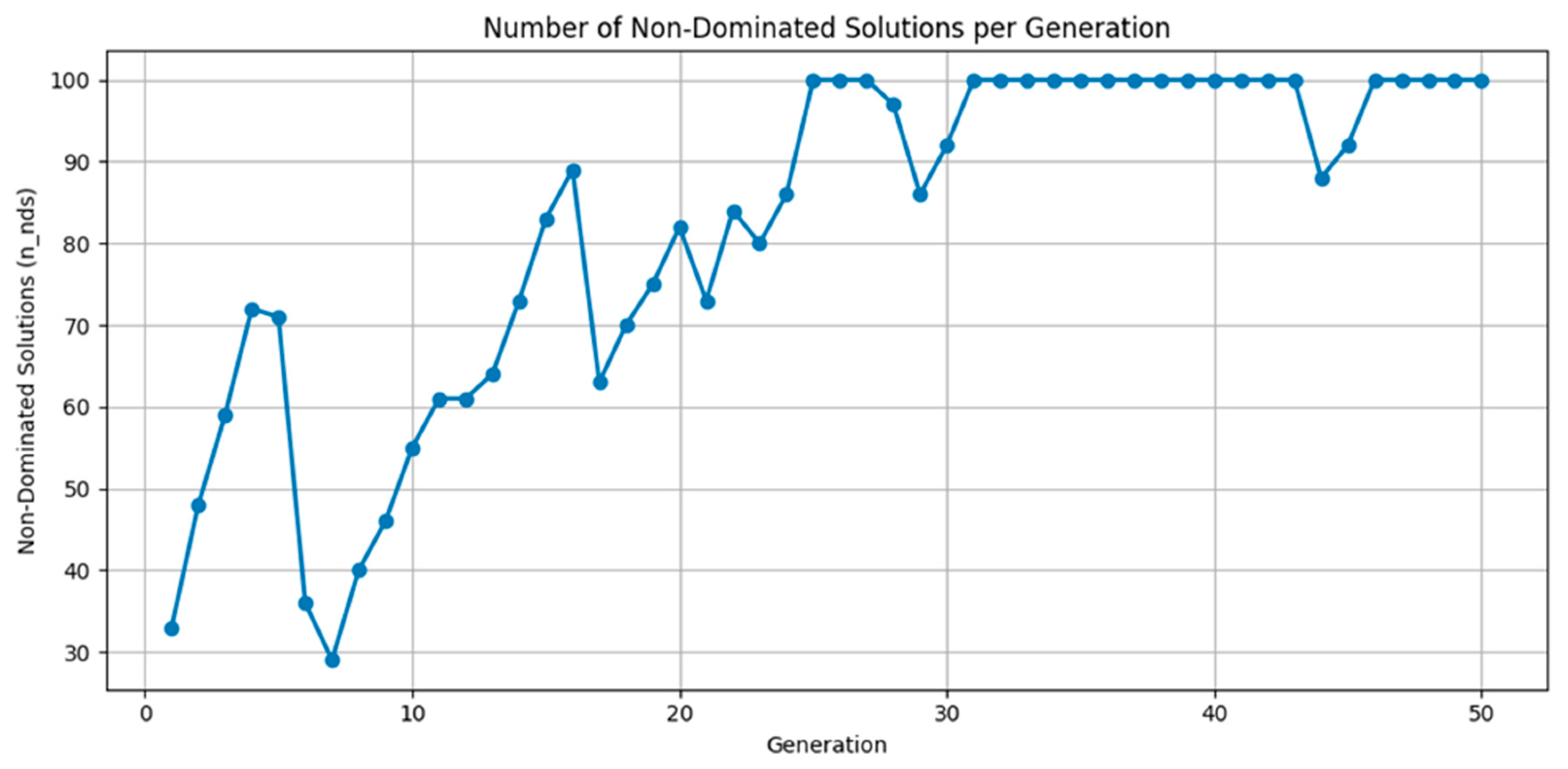
To support the parameter selection described in Section 3.2, we present the evolution of the non-dominated solutions and the epsilon indicator over 50 generations of the NSGA-II algorithm.
Figure A3 shows the number of non-dominated solutions at each generation. The population gradually diversifies in the early stages, reaching the maximum of 100 non-dominated individuals by generation 25 and maintaining this level throughout the later generations. This indicates that the algorithm achieved and sustained a high level of solution diversity and Pareto front coverage.
Figure A3.
Number of non-dominated solutions per generation (NSGA-II).
Figure A4 presents the epsilon indicator, which quantifies the change in the Pareto front between generations. The indicator exhibits an overall decreasing trend with some fluctuations during the middle stages, and stabilizes at low values (below 0.02) after approximately 30 generations. This behavior confirms that the optimization process achieved convergence while maintaining search activity under the chosen parameter settings.
Figure A4.
Epsilon indicator values across generations.
References
- Cervero, R.; Kockelman, K. Travel demand and the 3Ds: Density, diversity, and design. Transp. Res. Part D Transp. Environ. 1997, 2, 199–219. [Google Scholar] [CrossRef]
- Bertolini, L. Spatial Development Patterns and Public Transport: The Application of an Analytical Model in the Netherlands. Plan. Pract. Res. 1999, 14, 199–210. [Google Scholar] [CrossRef]
- Curtis, C.; Renne, J.L.; Bertolini, L. Transit Oriented Development: Making it Happen; Ashgate Publishing, Ltd.: Surrey, UK, 2009. [Google Scholar]
- Papa, E.; Bertolini, L. Accessibility and Transit-Oriented Development in European metropolitan areas. J. Transp. Geogr. 2015, 47, 70–83. [Google Scholar] [CrossRef]
- Lin, J.J.; Gau, C.C. A TOD planning model to review the regulation of allowable development densities around subway stations. Land Use Policy 2006, 23, 353–360. [Google Scholar] [CrossRef]
- He, J. Design of Underground Space Around Metro Station Based on TOD Theory. 2021. Available online: https://www.politesi.polimi.it/handle/10589/177488 (accessed on 22 June 2025).
- Li, H.; Li, X.; Soh, C.K. An integrated strategy for sustainable development of the urban underground: From strategic, economic and societal aspects. Tunn. Undergr. Space Technol. 2016, 55, 67–82. [Google Scholar] [CrossRef]
- Dong, Y.-H.; Peng, F.-L.; Guo, T.-F. Quantitative assessment method on urban vitality of metro-led underground space based on multi-source data: A case study of Shanghai Inner Ring area. Tunn. Undergr. Space Technol. 2021, 116, 104108. [Google Scholar] [CrossRef]
- Lin, D.; Nelson, J.D.; Beecroft, M.; Cui, J. An overview of recent developments in China’s metro systems. Tunn. Undergr. Space Technol. 2021, 111, 103783. [Google Scholar] [CrossRef]
- Peng, F.-L.; Qiao, Y.-K.; Zhao, J.-W.; Liu, K.; Li, J.-C. Planning and implementation of underground space in Chinese central business district (CBD): A case of Shanghai Hongqiao CBD. Tunn. Undergr. Space Technol. 2020, 95, 103176. [Google Scholar] [CrossRef]
- Israel, A. Issues for Infrastructure Management in the 1990s; World Bank Publications: Washington, DC, USA, 1992. [Google Scholar]
- Nuuyandja, H.; Pisa, N.; Masoumi, H.; Chakamera, C. Association of Urban Form, Neighbourhood Characteristics, and Socioeconomic Factors with Travel Behaviour in Windhoek, Namibia. Sustainability 2025, 17, 7800. [Google Scholar] [CrossRef]
- Chen, Q.; Bai, Y.; Zheng, N. Simulation and Optimization of Pedestrian Regular Evacuation in Comprehensive Rail Transit Hub—A Case Study in Beijing. Promet-Traffic Transp. 2020, 32, 383–397. [Google Scholar] [CrossRef]
- Zhao, P. Car use, commuting and urban form in a rapidly growing city: Evidence from Beijing. Transp. Plan. Technol. 2011, 34, 509–527. Available online: https://www.tandfonline.com/doi/abs/10.1080/03081060.2011.600049 (accessed on 27 August 2025). [CrossRef]
- Mees, P. TOD and Multi-modal Public Transport. Plan. Pract. Res. 2014, 29, 461–470. Available online: https://www.tandfonline.com/doi/abs/10.1080/02697459.2014.977633 (accessed on 17 June 2025). [CrossRef]
- Mariette, J.; Blanchard, O.; Berne, O.; Aumont, O.; Carrey, J.; Ligozat, A.; Lellouch, E.; Roche, P.-E.; Guennebaud, G.; Thanwerdas, J.; et al. An open-source tool to assess the carbon footprint of research. Environ. Res. Infrastruct. Sustain. 2022, 2, 035008. [Google Scholar] [CrossRef]
- Durmiševic, S. Perception Aspects in Underground Spaces Using Intelligent Knowledge Modeling; TU Delft: Delft, The Netherlands, 2002. [Google Scholar]
- Jin, Y.; Wang, H.; Chugh, T.; Guo, D.; Miettinen, K. Data-Driven Evolutionary Optimization: An Overview and Case Studies. IEEE Trans. Evol. Comput. 2019, 23, 442–458. [Google Scholar] [CrossRef]
- Zhen, F.; Zhang, S.; Qin, X.; Xi, G. From informational empowerment to comprehensive empowerment: Exploring the ideas of smart territorial spatial planning. J. Nat. Resour. 2019, 34, 2060. [Google Scholar] [CrossRef]
- Yajie, X.; Chen, X. Current Situation and Prospect of Comprehensive Development of Underground Space in Metro Area. Chin. J. Undergr. Space Eng. 2023, 19, 1–12. [Google Scholar]
- Mohammadi, A.; Amador-Jimenez, L.; Nasiri, F. Reliable, Effective, and Sustainable Urban Railways: A Model for Optimal Planning and Asset Management. J. Constr. Eng. Manag. 2020, 146, 04020057. [Google Scholar] [CrossRef]
- Shao, F.; Wang, Y. Intelligent overall planning model of underground space based on digital twin. Comput. Electr. Eng. 2022, 104, 108393. [Google Scholar] [CrossRef]
- Zhang, Y.; Zhu, J.; Liao, Z.; Guo, J.; Xie, H.; Peng, Q. An intelligent planning model for the development and utilization of urban underground space with an application to the Luohu District in Shenzhen. Tunn. Undergr. Space Technol. 2021, 112, 103933. [Google Scholar] [CrossRef]
- Peng, F.-L.; Dong, Y.-H.; Wang, W.-X.; Ma, C.-X. The next frontier: Data-driven urban underground space planning orienting multiple development concepts. Smart Constr. Sustain. Cities 2023, 1, 3. [Google Scholar] [CrossRef]
- Zhuang, Y.; Liu, P.; Yang, H.; Zhang, K.; Wang, Y.; Pu, Z. Few-shot learning for novel object detection in autonomous driving. Commun. Transp. Res. 2025, 5, 100194. [Google Scholar] [CrossRef]
- Dong, Y.-H.; Peng, F.-L.; Zha, B.-H.; Qiao, Y.-K.; Li, H. An intelligent layout planning model for underground space surrounding metro stations based on NSGA-II. Tunn. Undergr. Space Technol. 2022, 128, 104648. [Google Scholar] [CrossRef]
- Deb, K.; Pratap, A.; Agarwal, S.; Meyarivan, T. A fast and elitist multiobjective genetic algorithm: NSGA-II. IEEE Trans. Evol. Comput. 2002, 6, 182–197. [Google Scholar] [CrossRef]
- Verma, S.; Pant, M.; Snasel, V. A Comprehensive Review on NSGA-II for Multi-Objective Combinatorial Optimization Problems. IEEE Access 2021, 9, 57757–57791. [Google Scholar] [CrossRef]
- Xiang, Z.; Wang, B.; Xue, J.; Shan, S. Research on practical application of multi-objective optimization based on NSGA-II algorithm. Adv. Appl. Math. 2023, 12, 4195. [Google Scholar] [CrossRef]
- Lin, Y.-K.; Yeh, C.-T. Multi-objective optimization for stochastic computer networks using NSGA-II and TOPSIS. Eur. J. Oper. Res. 2012, 218, 735–746. [Google Scholar] [CrossRef]
- Hazbei, M.; Rafati, N.; Kharma, N.; Eicker, U. Optimizing architectural multi-dimensional forms; a hybrid approach integrating approximate evolutionary search, clustering and local optimization. Energy Build. 2024, 318, 114460. [Google Scholar] [CrossRef]
- Rafati, N.; Hazbei, M.; Eicker, U. Louver configuration comparison in three Canadian cities utilizing NSGA-II. Build. Environ. 2023, 229, 109939. [Google Scholar] [CrossRef]
- Senanayake, G.P.D.P.; Kieu, M.; Zou, Y.; Dirks, K. Agent-based simulation for pedestrian evacuation: A systematic literature review. Int. J. Disaster Risk Reduct. 2024, 111, 104705. [Google Scholar] [CrossRef]
- Shi, X.; Qiao, Y.; Zhao, X.; Liu, Y.; Liu, C.; Huang, R.; Cui, Y. Improving emergency evacuation capacity for subway stations based on agent-based modelling. Constr. Innov. 2024. ahead-of-print. [Google Scholar] [CrossRef]
- Chen, X.; Wei, C.; Yang, Y.; Luo, L.; Biancardo, S.A.; Mei, X. Personnel Trajectory Extraction From Port-Like Videos Under Varied Rainy Interferences. IEEE Trans. Intell. Transp. Syst. 2024, 25, 6567–6579. [Google Scholar] [CrossRef]
- Chan, H.-Y.; Ip, L.-C.; Mansoor, U.; Chen, A. Pedestrian route choice with respect to new lift-only entrances to underground space: Case study of a metro station area in hilly terrain in Hong Kong. Tunn. Undergr. Space Technol. 2022, 129, 104678. [Google Scholar] [CrossRef]
- Weidmann, U. Transporttechnik der Fussgänger: Transporttechnische Eigenschaften des Fussgängerverkehrs, Literaturauswertung; ETH Zurich: Zurich, Switzerland, 1992. [Google Scholar] [CrossRef]
- Hurley, M.J.; Gottuk, D.T.; Hall, J.R.; Harada, K.; Kuligowski, E.D.; Puchovsky, M.; Torero, L.; Watts, J.M. SFPE Handbook of Fire Protection Engineering; Springer: Berlin/Heidelberg, Germany, 2015. [Google Scholar]
- Kramer, O. A Review of Constraint-Handling Techniques for Evolution Strategies. Appl. Comput. Intell. Soft Comput. 2010, 2010, 185063. [Google Scholar] [CrossRef]
- Ma, H.; Zhang, Y.; Sun, S.; Liu, T.; Shan, Y. A comprehensive survey on NSGA-II for multi-objective optimization and applications. Artif. Intell. Rev. 2023, 56, 15217–15270. [Google Scholar] [CrossRef]
- Dudas, C.; Ng, A.H.C.; Boström, H. Post-analysis of multi-objective optimization solutions using decision trees. Intell. Data Anal. 2015, 19, 259–278. Available online: https://journals.sagepub.com/doi/abs/10.3233/IDA-150716 (accessed on 19 June 2025). [CrossRef]
- Zhang, X.; Zhang, Q.; Sun, T. Performance evaluation and obstacle factors analysis of urban public transport priority. Transp. Plan. Technol. 2019, 42, 696–713. [Google Scholar] [CrossRef]
- Sun, X.; Hu, W.; Xue, X.; Dong, J. Multi-objective optimization model for planning metro-based underground logistics system network: Nanjing case study. J. Ind. Manag. Optim. 2023, 19, 170. Available online: https://openurl.ebsco.com/EPDB%3Agcd%3A8%3A34565128/detailv2?sid=ebsco%3Aplink%3Ascholar&id=ebsco%3Agcd%3A159631038&crl=c&link_origin=scholar.google.com (accessed on 22 June 2025). [CrossRef]
- Helmrich, A.; Markolf, S.; Li, R.; Carvalhaes, T.; Kim, Y.; Bondank, E.; Natarajan, M.; Ahmad, N.; Chester, M. Centralization and decentralization for resilient infrastructure and complexity. Environ. Res. Infrastruct. Sustain. 2021, 1, 021001. [Google Scholar] [CrossRef]
- Shinde, A.M.; Dikshit, A.K.; Soni, A. Environmental life cycle assessment of underground metro rail: A case study in Mumbai Metropolitan Region, India. Environ. Impact Assess. Rev. 2024, 106, 107501. [Google Scholar] [CrossRef]
- Liu, T.; Zhu, H.; Shen, Y.; Li, T.; Liu, A. Embodied carbon assessment on road tunnels using integrated digital model: Methodology and case-study insights. Tunn. Undergr. Space Technol. 2024, 143, 105485. [Google Scholar] [CrossRef]
- Geurs, K.T.; van Wee, B. Accessibility evaluation of land-use and transport strategies: Review and research directions. J. Transp. Geogr. 2004, 12, 127–140. [Google Scholar] [CrossRef]
- Yu, J.; Shen, Z.; Huang, Z.; Li, H. Optimization design of anti-seismic engineering measures for intake tower based on non-dominated sorting genetic algorithm-II. Front. Struct. Civ. Eng. 2023, 17, 1428–1441. [Google Scholar] [CrossRef]
- Wang, D.; Wang, G.; Wang, H. Optimal Lane Change Path Planning Based on the NSGA-II and TOPSIS Algorithms. Appl. Sci. 2023, 13, 1149. [Google Scholar] [CrossRef]
- Krivorotko, M.; Setoguchi, T.; Watanabe, N. Efficient Public Underground Pedestrian Space in a Cold-Climate City: A Case Study of Sapporo, Japan. Sustainability 2024, 16, 9995. [Google Scholar] [CrossRef]
- Spyrou, E.D.; Kappatos, V.; Gkemou, M.; Bekiaris, E. Multimodal Transport Optimization from Doorstep to Airport Using Mixed-Integer Linear Programming and Dynamic Programming. Sustainability 2025, 17, 7937. [Google Scholar] [CrossRef]
- Jagarlamudi, L. Examining the Effectiveness of Park-and-Ride Facilities in German Metropolitan Areas: Promoting Modal Shift and Mitigating Traffic Congestion. 2024. Available online: https://libdoc.fh-zwickau.de/opus4/frontdoor/index/index/docId/17356 (accessed on 22 June 2025).
- Zhao, X.; Li, Y.; Xia, H. Behavior decision model for park-and-ride facilities utilization. Adv. Mech. Eng. 2017, 9, 1687814017708907. [Google Scholar] [CrossRef]
- Yang, S.; Wang, G.; Xu, Q.; He, J.; Yang, M.; Su, C. Dynamic Response Study of Space Large-Span Structure under Stochastic Crowd-Loading Excitation. Buildings 2024, 14, 1203. [Google Scholar] [CrossRef]
- Goel, R.K.; Singh, B.; Zhao, J. Underground Infrastructures: Planning, Design, and Construction; Butterworth-Heinemann: Oxford, UK, 2012. [Google Scholar]
- Furlan, R.; Al-Mohannadi, A.; Major, M.D.; Paquet, T.N.K. A planning method for transit villages in Qatar: Souq Waqif historical district in Doha. Open House Int. 2022, 48, 425–446. [Google Scholar] [CrossRef]
- Taboada, H.A.; Baheranwala, F.; Coit, D.W.; Wattanapongsakorn, N. Practical solutions for multi-objective optimization: An application to system reliability design problems. Reliab. Eng. Syst. Saf. 2007, 92, 314–322. [Google Scholar] [CrossRef]
- Peng, T.; Zhou, J.; Zhang, C.; Sun, N. Modeling and Combined Application of Orthogonal Chaotic NSGA-II and Improved TOPSIS to Optimize a Conceptual Hydrological Model. Water Resour. Manag. 2018, 32, 3781–3799. [Google Scholar] [CrossRef]
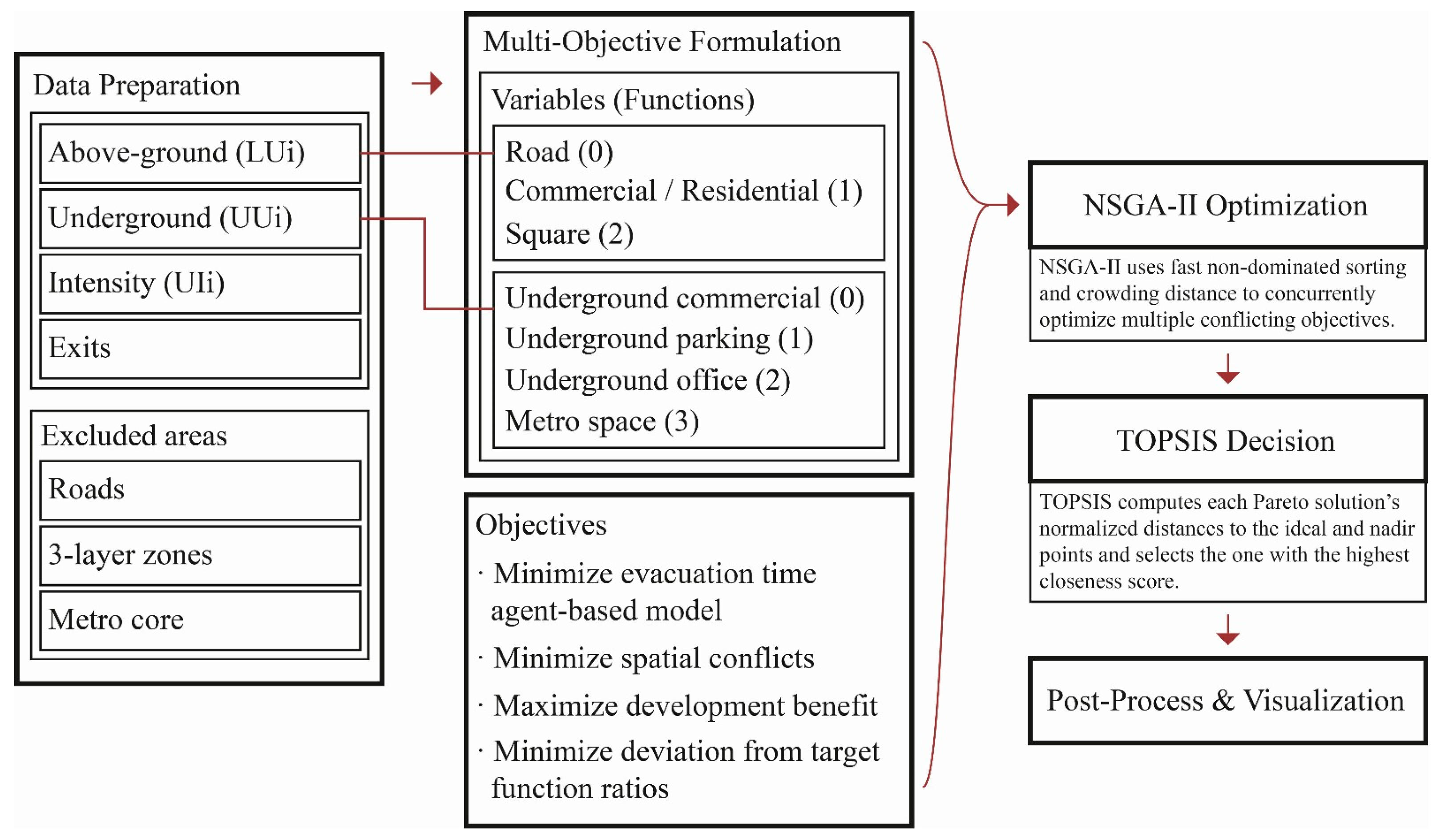
Disclaimer/Publisher’s Note: The statements, opinions and data contained in all publications are solely those of the individual author(s) and contributor(s) and not of MDPI and/or the editor(s). MDPI and/or the editor(s) disclaim responsibility for any injury to people or property resulting from any ideas, methods, instructions or products referred to in the content. |
© 2025 by the authors. Licensee MDPI, Basel, Switzerland. This article is an open access article distributed under the terms and conditions of the Creative Commons Attribution (CC BY) license (https://creativecommons.org/licenses/by/4.0/).