Abstract
This study addresses a key challenge in water resource management, focusing on spring water. Rapidly increasing water demand, owing to population growth and shifting climate conditions, threatens water availability. Although springs are vital and renewable, they remain largely untapped sources of freshwater worldwide. This study aims to estimate the volume of spring water that can be sustainably extracted from selected catchments without causing environmental harm. It is assumed that substantial water volumes can be withdrawn from catchments where aquifers consist of Cretaceous or Tertiary sediments. By applying the Threshold Level Method (TLM), the study ensures that extraction adherence to environmental flow requirements, thereby helping to protect surrounding aquatic and terrestrial ecosystems. Assuming a daily per capita water use of 0.2 m3, the surplus spring water identified could meet the needs of approximately 881,545 people, whereas the study area’s population slightly exceeds 1.2 million. These findings support sustainable water management efforts and advance progress toward UN Sustainable Development Goal 6. The results demonstrate that sustainable spring water use can help reduce groundwater overexploitation and maintain ecological integrity.
1. Introduction
Although water covers over 80% of the planet’s surface, it is increasingly viewed as a limited resource. Groundwater is a major source of freshwater worldwide [1]. It is primarily replenished by precipitation through the infiltration process, during which natural purification occurs. Recharge may also occur via seepage from surface water bodies or irrigation systems [2]. Rising water demand poses a serious threat to groundwater resources, particularly when the extraction rate exceeds that of natural recharge. According to Twinomucunguzi et al. [3], more than 30% of global groundwater is under constant human pressure, causing its overexploitation [4]. Climate change amplifies this problem by altering precipitation patterns and reducing recharge efficiency [5]. Increased air temperatures lead to higher evaporation rates and water losses, whereas in some regions, altered winter thawing periods hinder infiltration [6]. Intense precipitation events often result in surface runoff rather than infiltration. To address these risks, sustainable groundwater management aims to prevent overextraction [7]. Springs, where groundwater naturally emerges at the surface, may offer a viable solution to water scarcity, not only in arid regions but also in temperate climates [8]. As a renewable source of freshwater, springs play a vital role in maintaining both human water supply and ecological balance. However, the use of spring water varies significantly among regions. Examples of spring use include alpine areas such as the Alps [9] and the Himalayas [10], as well as arid climates [11]. Sustainable spring water management supports water security and ecosystem resilience [12]. The occurrence and characteristics of springs are determined by geological features, including lithology, porosity, permeability, and topography [13]. In many underdeveloped countries, spring water is used for drinking and domestic purposes [14]. In Poland, regions such as the Carpathian Mountains, Lublin Upland, and Roztocze are rich in springs [15]; however, their potential remains untapped. In these sparsely urbanized areas, where nearly 70% of the land is occupied by farmland and 20% by forests (Figure 1) [16], spring water extraction has the potential to serve as a primary source of water supply.
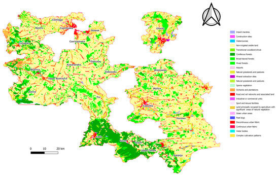
Figure 1.
Land cover of the study area.
Despite Poland’s relatively abundant groundwater reserves [17], research on the sustainable use of spring water, particularly at the catchment level and in non-arid regions, remains limited. Most water resource studies in the region have centered on deep aquifer exploitation or large-scale hydrogeological assessments [18], overlooking the role of springs as naturally regulated, renewable, and low-impact water sources. Furthermore, southeastern Poland, especially the Lublin Upland and Roztocze regions, contains numerous spring-fed systems that remain largely underutilized and unquantified regarding their sustainable extraction potential. This study addresses that gap by applying a conservative flow threshold approach (Q90), adapted from the Threshold Level Method (TLM), to quantify the volume of spring water that could be safely extracted without compromising ecological or hydrological integrity (Figure 2). Q90 is widely recognized in both the hydrological and ecological literature as a conservative threshold for defining low-flow conditions and establishing minimum environmental flow requirements. Recent studies, such as Virkki et al.’s [19], have utilized Q90 in global assessments of environmental flow violations, highlighting its relevance in evaluating hydrological stress under changing climatic conditions. Additionally, Berthot et al. [20] discussed the application of Q90 in the context of climate change, emphasizing its utility in adapting environmental flow assessments to non-stationary hydrological regimes. These applications underscore Q90’s continued reliability in representing flow conditions during periods of natural stress. By integrating hydrological analysis with spatial, geological, and demographic data, this study offers a novel framework for evaluating spring water as a strategic resource in climate-resilient water planning, even in regions not yet classified as water-scarce.
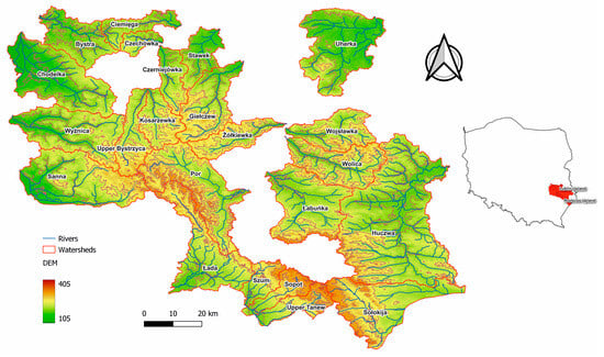
Figure 2.
Study area.
This study aims to estimate the volume of spring water that can be sustainably extracted from selected catchments in the Lublin Upland and Roztocze regions without causing environmental degradation. Assuming a daily per capita water consumption of approximately 225 L, typical of developed countries, the number of people whose water needs could be met by these resources is calculable. We hypothesized that substantial volumes of water could be extracted sustainably from catchments with aquifers composed of Cretaceous and Tertiary sediments.
2. Materials and Methods
2.1. Study Area
The Lublin Upland and Roztocze regions are located in southeastern Poland. The study area is distinguished by its unique landscapes and rich biodiversity. For instance, Roztocze National Park provides the highest level of environmental protection in the region [21]. Detailed hydrological analyses were conducted across 23 catchments situated in the interfluve between the Vistula and Bug rivers (Figure 2). The catchments varied in stream order (ranging from 2nd to 5th), elevation (from 104 m a.s.l. to 404 m a.s.l.), and surface area (from 76.6 km2 in the Czechówka catchment to 1393 km2 in the Huczwa catchment). Of these, 20 catchments drain westward into the Vistula River, whereas the remaining three discharge eastward into the Bug River.
This area exhibits pronounced differences in elevation and water flow dynamics. In the near-surface layer, the Lublin Upland and Roztocze regions are primarily composed of various carbonate rocks, most commonly opokas and marls [22]. In the northwestern part of the area, Paleocene marly limestones and gauze occur, whereas the southern part is dominated by Neogene limestones and sandstones [23]. On plateaus, carbonate sediments are typically overlain by sandy and silty deposits and loess. In contrast, river valleys are filled with Pleistocene sandy sediments, Holocene silts, and organic deposits. The main aquifer is found within Cretaceous carbonate sediments, with additional aquifers occasionally occurring in Tertiary and Quaternary rocks. Frequently, Cretaceous and Tertiary formations form a Cretaceous–Tertiary aquifer complex [24]. The region’s geological structure, particularly the permeability and porosity of the rocks, combined with favorable climatic conditions, supports the natural emergence of springs throughout the Lublin Upland and Roztocze. Within the studied catchments, 923 springs were identified, varying in discharge rate, elevation, and the aquifer type. For the purpose of estimating the potential for spring water extraction, only springs draining from the most productive Cretaceous and Tertiary aquifers were considered.
2.2. Field Research
Field measurements (conducted between 2021 and 2023) and publicly accessible data from online sources were utilized in this study. The primary data for calculating spring discharge were obtained through in situ measurements using a Valeport 801 current meter. Spring discharge (Q) was measured at the outflow of the spring niche using the area–velocity method as shown in the Equation (1), with the Valeport 801 current meter applied to determine flow velocity and cross-sectional area.
where Q—discharge [L/s], A—cross-section area [dm3], and v—velocity [dm/s]
The primary objective was to determine the volume of spring water that could be sustainably extracted without causing environmental degradation. To achieve this, an analogy was drawn from the methods used to assess flow limits in watercourses during low-flow periods. Specifically, the Threshold Level Method (TLM), commonly applied to identify drought conditions in rivers, was employed for springs in the Lublin region [25]. Low-flow conditions in a watercourse were defined as periods when the discharge values were equal to or below a designated threshold. In this study, the limit flow Q90 was used as the critical breakpoint to identify shallow low-flow conditions. This threshold was derived from specific percentiles of the Flow Duration Curve (FDC, Equation (2)), which represents the relationship between discharge and the percentage of time that a given discharge is equal to or exceeded (Figure 3).
where P(Q)—exceedance probability (%) of a given discharge Q, m—rank of the discharge (sorted in descending order), and n—total number of observations.
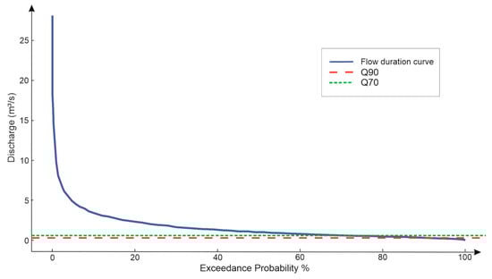
Figure 3.
FDC on an example of the Uherka basin.
The Q90 threshold was the discharge exceeded 90% of the time Equation (3)
The method is characterized by high reliability owing to the extended duration of the measurement sequences (derived from the flow duration curve) and a very low coefficient of variation [26]. For each of the 23 catchments, we constructed a Flow Duration Curve (FDC) using the collected discharge data. The FDC represents the percentage of time that specific flow values are equal to or exceed and serves as a basis for estimating environmental flow thresholds. Spring discharge values exceeding the Q90 threshold were treated as potentially usable surpluses, assuming that the extraction below this level would not compromise ecological or hydrological stability. For each analyzed river basin, the percentage share of low-flow discharge (baseflow) relative to the average annual discharge was calculated. Based on this ratio, a threshold value for spring water abstraction was established for each basin. To visualize the potential for sustainable spring water use, anamorphic maps were employed. This cartographic method emphasizes the spatial importance of a variable, in this case the volume of spring water that can be extracted without adverse ecological consequences, by distorting the size of spatial units (i.e., river basins) in proportion to the selected variable. The anamorphism process involved adjusting the surface area of each catchment to reflect the volume of potential water extraction while maintaining its original (non-geometrized) boundaries, referred to here as “basic fields” or anamorphic catchments. Cartograms were generated using a Geographic Information System (GIS) algorithm.
Additionally, the results were presented using a two-dimensional coordinate system, classified according to the methodology for constructing two-variable choropleth maps, with division into nine classes [27]. The interval ranges were determined based on the mean values of the indicators and their standard deviation (σ). In each case, the correlations between the potential volume of extractable spring water and specific catchment characteristics were analyzed.
3. Results
The analysis revealed notable spatial variations in the proportion of spring water that could be sustainably extracted across the study area (Figure 4). The catchments located in the eastern part of the region demonstrated the highest extraction potential, accounting for over 60% of the total spring yield. This area is part of the local groundwater drainage basin formed by the Bug River Valley, situated at approximately 160 m a.s.l. In contrast, the western part of the study area, drained toward the Vistula River, showed a slightly lower extraction potential, ranging from 40.8% to 60%. Among all the analyzed catchments, Uherka had the highest proportion of extractable water, reaching 76.8%. The Por catchment had the lowest potential, with only 40.8% of the spring water identified as suitable for sustainable use.
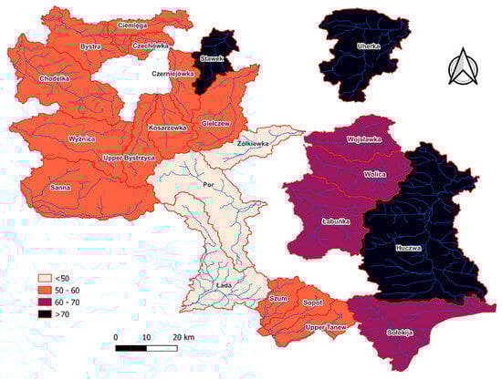
Figure 4.
Percentage of spring yield that could be extracted in the studied catchments, based on the TLM.
The total volume of spring water draining from the Tertiary and Cretaceous aquifers in the study area was 361,148 m3/day, with an average value of 15,702 m3/day per catchment. The catchments with the highest spring water yields were Giełczew (north), Łada (south), and Sanna (west), with daily discharge volumes of 81,631 m3, 29,954 m3, and 34,104 m3, respectively (Figure 5). In contrast, the smallest spring water resources were recorded in the Czechówka (400 m3/day), Żółkiewka (1589 m3/day), and Stawek (2263 m3/day) catchments, respectively. The Upper Tanew River catchment, with a total spring yield of 16,268 m3/day, was closest to the average value for the entire study area.
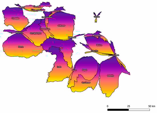
Figure 5.
Total volume of spring water draining Tertiary and Cretaceous aquifers in the study catchments.
The potential volume of spring water that could be sustainably extracted varied significantly across the study area. The highest extraction volume was recorded in the Giełczew catchment, with 18,239 m3/day, while the lowest was observed in the Czechówka catchment, at just 200 m3/day.
In the western part of the region, the Sanna and Chodelka catchments had the highest extraction capacities of 55,055 m3/day and 39,061 m3/day, respectively. In the central part, the catchments of the Łada, Upper Tanew, and Giełczew had similarly high values, with 83,152 m3/day, 84,523 m3/day, and 83,152 m3/day, respectively. In contrast, the eastern region showed a comparatively lower extraction potential. The Sołokija and Wolica catchments yielded only 18,239 m3/day and 8,665 m3/day, respectively.
A clear duality in the extraction potential was evident across the latitudinal gradient. The catchments in the northern part of the study area (e.g., Stawek, Czechówka, Uherka) were characterized by significantly lower potential than those in the south (e.g., Sopot, Por). One pronounce spatial feature was the adjacency of catchments with high and low extraction potential, underscoring the heterogeneous nature of spring water resources in the region (Figure 6).
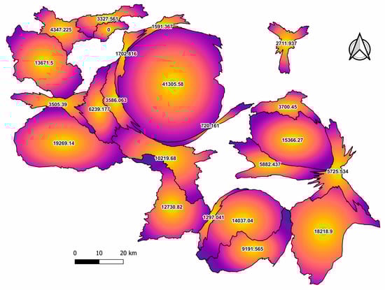
Figure 6.
Potential spring water extraction volume in the study catchments.
The analysis of the relationship between catchment characteristics and spring water yield, based on correlograms (Figure 6), revealed linear correlations ranging from weak to strong, depending on the variable assessed. The number of catchments showing a statistically significant correlation ranged from 6 (in the case of spring density ratio) to 13 (for both catchment area and length of the draining river). Residual analysis indicated both positive and negative deviations from the expected linear relationship. Between 10 and 17 catchments exhibited residuals across the studied characteristics. Positive deviations were observed in five to ten catchments, whereas negative deviations occurred in four to eight catchments.
Among the variables, the catchment area and river length had the most balanced residual distribution, with an equal number of catchments (five) showing positive and negative deviations. In contrast, the greatest discrepancy in residuals was observed for the catchment focal point elevation, where ten catchments showed positive residuals and only five showed negative residuals. In each case, the volume of potentially extractable spring water was compared to the corresponding catchment characteristics, providing insight into how physical and spatial variables influence water yield (Figure 7).
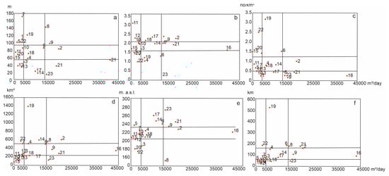
Figure 7.
Relationship between individual catchment characteristics and potential extraction volume: (a) elevation from the river source to mouth; (b) shape of the catchment; (c) spring density rate; (d) catchment area; (e) elevation of the focal point, and (f) length of the river.
The variation in elevation between a river’s source and outlet (i.e., the mouth of the watercourse) determines the hydraulic gradient of a catchment. Catchments with low gradients and correspondingly low spring water potential included Czerniejówka and Ciemięga. In Figure 7, moderate gradients and spring potential were observed in the Łabuńka, Łada, Wojsławka, and Bystrzyca catchments, while Chodelka and Wolica displayed both high gradients and high extraction potential (a). Overall, a linear correlation was observed between the hydraulic gradient and the volume of potentially extractable spring water, particularly in upland catchments. The catchment shape, expressed as the ratio of length to width (a dimensionless indicator of geometry), also showed a linear relationship with spring yield in nine catchments (b). This included five upland and four Roztocze catchments. Oval-shaped catchments tended to have lower extraction potential, while elongated catchments showed higher productivity. Positive residuals occurred in eight catchments, all of which were upland catchments draining toward the Vistula. Negative deviations from the correlation were observed in six catchments, equally split between upland and Roztocze regions. Spring density, defined as the number of springs per km2, displayed relatively high deviations from linearity. Positive residuals were found in nine catchments, the majority (six) located in the Lublin Upland (c). Negative residuals occurred in eight catchments: four in the Upland and four in Roztocze. The catchment area also showed a relatively consistent pattern of correlation with spring water extraction volume. Thirteen catchments exhibited a linear relationship, with nine located in the Upland and four in Roztocze (d). Thirteen catchments displayed linearity: seven were weak, four were moderate, and two were strong. A clear linear relationship was also found between the elevation of a catchment’s focal point and its spring water extraction potential. Nine catchments demonstrated this correlation. Low focal point elevation and low spring productivity were observed in three upland catchments: Stawek, Uherka, and Czerniejówka, likely due to human impact. Moderate focal point elevation and spring productivity were observed in three additional catchments. The strongest correlations were found in the Roztocze catchments with higher focal point elevations, such as Sołokija and Sopot, which also had high extraction potential (e). In total, 10 catchments showed positive residuals, whereas only four showed negative residuals. Finally, the length of the river serving as the local drainage base was correlated with spring water potential in 13 catchments. Seven catchments showed a weak correlation, four moderate, and two strong (Chodelka and Sołokija) (f). Positive and negative residuals were balanced, with five catchments each—four upland and one Roztocze catchment in each group.
The Giełczew River catchment was a clear outlier in the analysis. Despite producing the region’s highest spring yield, it showed consistently negative residuals across all examined variables, indicating unique hydrological and geomorphological characteristics.
The total volume of surplus spring water identified in the study area could meet the water demand of approximately 881,545 people in the region. Remarkably, the Giełczew catchment alone could meet the needs of more than 180,000 individuals (Figure 8). Given that the study area is home to just over 1.2 million people, the findings suggest that the sustainable utilization of spring water could meet a substantial portion, if not nearly all, of the region’s water demand.
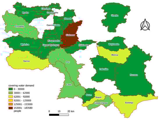
Figure 8.
Potential covering water demand in the study catchment areas.
Once demographic data and population distribution were factored in, spatial differences in per-capita water availability became more pronounced. Areas with the greatest overall potential also showed the widest disparities, whereas catchments such as Uherka, Wyżnica, Czechówka, Stawek, and Czerniejówka exhibited relatively uniform values (Figure 9). Conversely, the smallest differences were recorded in the Uherka, Wyżnica, Czechówka, Stawek, and Czerniejówka catchments.
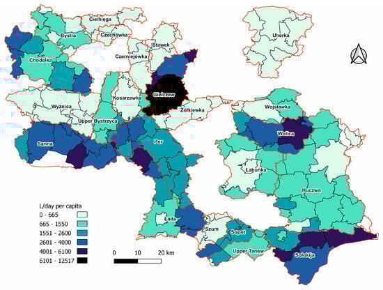
Figure 9.
Daily volume of potentially extracted spring water per capita.
4. Discussion
This study presents a strategy for utilizing underexploited spring water resources to address ongoing water scarcity, not only in arid and semi-arid regions, but also in temperate areas where water stress is increasingly evident. This contributes to the global discourse on sustainable water management [28,29] by positioning spring water as a reliable, although often undervalued, resource.
Hydrogeological conditions within a drainage basin are widely recognized as critical determinants of outflow potential [30]. These conditions depend on relatively stable factors such as terrain, aquifer characteristics, catchment area, and land use development [31]. While understanding these factors is essential, the study findings indicate that they alone are insufficient to fully explain the variability in the potential for sustainable spring water extraction. Spring occurrence and yield are significantly influenced by dynamic factors that vary over time and space, including meteorological conditions (e.g., precipitation, air and water temperature), hydrological fluctuations (inflow and outflow volumes over time), and anthropogenic pressures (e.g., abstraction and retention).
In an era marked by global water shortages, driven by both climate change and population growth and exacerbated by overexploitation of groundwater resources [32,33], the sustainable management of water resources is increasingly urgent [34]. Recharge of headwater supports baseflow maintenance during dry periods [12], whereas surplus water in other seasons can be safely used for agriculture, domestic supply, and other purposes without significant ecological costs. The study area showed spatial variation in the share of spring water surplus (i.e., the proportion of discharge that can be sustainably used). In the eastern catchments, high discharge amplitudes and deep flow lows during precipitation-deficient periods suggest the theoretical potential for spring water use. However, these areas typically contain fewer springs with lower yields, which limits their actual utility. In contrast, western catchments are drained by high-capacity karst aquifers overlain by loess-covered Cretaceous formations. These aquifers are characterized by high hydrological inertia and support springs with low-yield variability, offering the highest potential for sustainable use [15,22]. Meanwhile, springs in the eastern region respond more dynamically to atmospheric inputs and show greater yield fluctuations [35].
Despite statistically significant correlations between spring yield and catchment-scale parameters, none of these variables were reliable determinants of sustainable water use potential. This suggests the influence of macro-scale controls, most notably tectonic factors [36,37]. The springs analyzed in both the Lublin Upland and Roztocze drain a structurally uniform Upper Cretaceous carbonate massif [38] dissected by river valleys that play a key role in shaping regional groundwater circulation [39]. The distribution and productivity of springs closely align with tectonic dislocation zones or lineaments, indicating structural control on spring emergence and yield [40,41].
Assuming a daily per capita water demand of 225 L, the spring water resources identified in this study can meet the needs of approximately 80% of the population in the study area. Notably, the Giełczew catchment alone could supply water to over 183,000 people. Urbanized areas, particularly Lublin, Chełm, Zamość, Świdnik, and Kraśnik, significantly contributed to the spatial variation in water potential. Although these cities rely heavily on high-quality groundwater, the exploitation of spring water is minimal. Given the ongoing global water crisis, the sustainable management and use of spring water should be regarded as a viable and ecologically responsible alternative to the intensified groundwater extraction. This study underscores the value of integrating spring water into regional water strategies to enhance resilience, reduce groundwater stress, and support long-term water security.
5. Conclusions
This study demonstrates that underutilized spring water resources represent a viable and ecologically sound alternative for meeting regional water demands, even in areas with relatively abundant groundwater resources. By applying the Threshold Level Method (TLM) and using the Q90 low-flow threshold derived from Flow Duration Curves, we established a conservative hydrological approach for estimating the sustainable extraction potential of springs in 23 catchments across southeastern Poland.
Key findings include:
- Spatial variability: Western catchments, draining Cretaceous carbonate aquifers, showed the highest sustainable extraction potential. Eastern catchments, despite their high theoretical capacity, were limited by low yields and unstable discharge.
- Significant volume: Sustainable extraction across the region could supply daily water for approximately 881,500 people (≈75% of the regional population), with the Giełczew catchment alone capable of supporting over 180,000 individuals.
- Methodology: The Q90-based TLM offers a low-data, transferable, and precautionary tool aligned with environmental flow protection and sustainability principles.
Importantly, this research challenges the assumption that water resource management is only necessary in regions of water scarcity. Effective sustainable development requires proactive planning and supply diversification, even in hydrologically rich regions. Springs, as naturally regulated low-impact sources, can reduce dependence on deep aquifers, especially in the context of growing population pressure and climate-induced recharge uncertainty. The Q90-based method adopted in this study offers a transferable, low-data-requirement approach aligned with environmental flow protection and precautionary sustainability principles.
By tapping underexploited spring sources, regional and municipal water systems, especially in urban centers such as Lublin, Chełm, Zamość, Świdnik, and Kraśnik, can alleviate pressure on deep aquifers, enhance water security for both rural and urban communities, and reduce socio-economic vulnerability, particularly under increasing demand and climate stress.
Regional and municipal water strategies should consider integrating spring water as a formal component of the water supply.
Author Contributions
Conceptualization, B.F. and J.D.; methodology, B.F. and J.D.; software, B.F.; validation, B.F. and J.D.; formal analysis, B.F.; investigation, B.F. and J.D.; writing—original draft preparation, B.F. and J.D.; writing—review and editing, B.F.; visualization, B.F.; supervision, B.F. All authors have read and agreed to the published version of the manuscript.
Funding
This research received no external funding.
Institutional Review Board Statement
Not applicable.
Informed Consent Statement
Not applicable.
Data Availability Statement
The dataset is available on request from the authors.
Conflicts of Interest
The authors declare that they have no known competing financial interests or personal relationships that could have appeared to influence the work reported in this paper.
References
- Li, R. Assessing Groundwater Pollution Risk in Response to Climate Change and Variability. In Emerging Issues in Groundwater Resources; Fares, A., Ed.; Springer: Cham, Switzerland, 2016; pp. 31–50. [Google Scholar]
- Li, Y.; Fu, Q.; Li, T.; Liu, D.; Hou, R.; Li, Q.; Yi, J.; Li, M.; Meng, F. Snow melting water infiltration mechanism of farmland freezing-thawing soil and determination of meltwater infiltration parameter in seasonal frozen soil areas. Agric. Water Manag. 2021, 258, 107165. [Google Scholar] [CrossRef]
- Twinomucunguzi, F.R.B.; Nyenje, P.M.; Kulabako, R.N.; Semiyaga, S.; Foppen, J.W.; Kansiime, F. Emerging Organic Contaminants in Shallow Groundwater Underlying Two Contrasting Peri-Urban Areas in Uganda. Environ. Monit. Assess. 2021, 193, 228. [Google Scholar] [CrossRef] [PubMed]
- De Graf, I.E.M.; Stahl, K. A Model Comparison Assessing the Importance of Lateral Groundwater Flows at the Global Scale. Environ. Res. Lett. 2022, 17, 044020. Available online: https://iopscience.iop.org/article/10.1088/1748-9326/ac50d2 (accessed on 30 November 2021). [CrossRef]
- Swain, S.; Taloor, A.K.; Dhal, L.; Sahoo, S.; Al-Ansari, N. Impact of climate change on groundwater hydrology: A comprehensive review and current status of the Indian hydrogeology. Appl. Water Sci. 2022, 12, 120. [Google Scholar] [CrossRef]
- Kumar, D.; Singh, A.K.; Taloor, A.K.; Singh, D.S. Recessional Pattern of Thelu and Swetvarn Glaciers Between 1968 and 2019, Bhagirathi Basin, Garhwal Himalaya, India. Quat. Int. 2021, 575–576, 227–235. [Google Scholar] [CrossRef]
- Talabi, A.; Abdu-Raheem, Y.; Afolagboye, L.; Oguntuase, M.; Akinola, O. Hydrogeochemistry of shallow groundwater in Ado-Ekiti Area, Southwestern Nigeria. Groundw. Sustain. Dev. 2020, 11, 100386. [Google Scholar] [CrossRef]
- Oberhauser, D.; Hägele, R.; Dombrowsky, I. Unravelling hidden factors explaining competition for and overuse of groundwater in Azraq, Jordan: Digging deeper into a network of action situations. Sustain. Sci. 2023, 18, 235–249. [Google Scholar] [CrossRef]
- Rehrl, C.; Birk, S. Hydrogeological Characterisation and Modelling of Spring Catchments in a Changing Environment. Austrian J. Earth Sci. 2010, 103, 106–117. [Google Scholar]
- Kumar, M.; Rathod, R.; Mukherji, A. Water Security and Spring Conservation in the Himalaya. In Climate Risks to Water Security: Framing Effective Response in Asia and the Pacific; Palgrave Macmillan: London, UK, 2023; pp. 15–36. [Google Scholar]
- Caldwell, T.G.; Wolaver, B.D.; Bongiovanni, T.; Pierre, J.P.; Robertson, S.; Abolt, C.; Scanlon, B.R. Spring Discharge and Thermal Regime of a Groundwater Dependent Ecosystem in an Arid Karst Environment. J. Hydrol. 2020, 587, 124947. [Google Scholar] [CrossRef]
- Lu, M.; Rogiers, B.; Beerten, K.; Gedeon, M.; Huysmans, M. Exploring River–Aquifer Interactions and Hydrological System Response Using Baseflow Separation, Impulse Response Modeling, and Time Series Analysis in Three Temperate Lowland Catchments. Hydrol. Earth Syst. Sci. 2022, 26, 3629–3649. [Google Scholar] [CrossRef]
- Taloor, A.K.; Pir, R.A.; Adimalla, N.; Ali, S.; Manhas, D.S.; Roy, S.; Singh, A.K. Spring Water Quality and Discharge Assessment in the Basantar Watershed of Jammu Himalaya Using Geographic Information System (GIS) and Water Quality Index (WQI). Groundw. Sustain. Dev. 2020, 10, 100364. [Google Scholar] [CrossRef]
- Chhimwal, M.; Kaur, S.; Srivastava, R.K.; Hagare, D.; Shiva Prasad, H.J. Water Quality of Springs and Lakes in the Kumaon Lesser Himalayan Region of Uttarakhand, India. J. Water Health 2022, 20, 737–754. [Google Scholar] [CrossRef] [PubMed]
- Ferencz, B.; Dawidek, J.; Bronowicka-Mielniczuk, U. Alteration of Yield and Springs Number as an Indicator of Climate Changes. Case Study of Eastern Poland. Ecol. Indic. 2022, 138, 108798. [Google Scholar] [CrossRef]
- Gawrysiak, L.; Baran-Zgłobicka, B.; Zgłobicki, W. Flash Floods Hazard to the Settlement Network versus Land Use Planning (Lublin Upland, East Poland). Appl. Sci. 2024, 14, 8425. [Google Scholar] [CrossRef]
- Krogulec, E.; Gurwin, J.; Wąsik, M. Cost of groundwater protection: Major groundwater basin protection zones in Poland. Int. Environ. Agreem. Politics Law Econ. 2021, 21, 517–530. [Google Scholar] [CrossRef]
- Dragon, K. Identification of Groundwater Conditions in the Recharge Zone of Regionally Extended Aquifer System with Use of Water Chemistry and Isotopes (Lwowek Region, Poland). J. Hydrol. Reg. Stud. 2021, 34, 100787. [Google Scholar] [CrossRef]
- Virkki, V.; Kummu, M.; Wang-Erlandsson, L.; Porkka, M.; Varis, O. Widespread Increasing Violations of Environmental Flow Envelopes. Earth Syst. Sci. 2022, 26, 3315–3331. [Google Scholar] [CrossRef]
- Berthot, N.; St-Hilaire, A.; Daigle, A.; Gauthier, Y. Environmental Flow Assessment in the Context of Climate Change: A Case Study in Southern Quebec, Canada. J. Water Clim. Change 2021, 12, 3617–3634. [Google Scholar] [CrossRef]
- Grabowski, T.; Jóźwiakowski, K.; Bochniak, A.; Micek, A. Changes in the Amount of Rainwater in the Roztocze National Park (Poland) in 2001–2020 and the Possibility of Using Rainwater in the Context of Ongoing Climate Variability. Water 2022, 14, 1334. [Google Scholar] [CrossRef]
- Zgłobicki, W.; Kukiełka, S.; Baran-Zgłobicka, B. Regional Geotourist Resources—Assessment and Management (A Case Study in SE Poland). Resources 2020, 9, 18. [Google Scholar] [CrossRef]
- Margielewski, W.; Jankowski, L.; Krąpiec, M.; Garecka, M.; Hałas, S.; Urban, J. Analysis of Reworked Sediments as a Basis of the Palaeogene-Neogene Palaeogeography Reinterpretation: Case Study of the Roztocze Region (SE Poland). Sediment. Geol. 2017, 352, 14–29. [Google Scholar] [CrossRef]
- Zieliński, M.; Dopieralska, J.; Królikowska-Ciągło, S.; Walcz, A.; Belka, Z. Mapping Spatial Variability of Sr Isotope Signatures (87Sr/86Sr) in Poland—Implications for Anthropogenic Sr Contamination in Archaeological Provenance and Migration Research. Sci. Total Environ. 2021, 775, 145792. [Google Scholar] [CrossRef]
- Raczyński, K.; Dyer, J. Development of an Objective Low Flow Identification Method Using Breakpoint Analysis. Water 2022, 14, 2212. [Google Scholar] [CrossRef]
- Cinkus, G.; Maz, N.; Jourde, H.; Wunsch, A.; Liesch, T.; Ravbar, N.; Chen, Z.; Goldscheider, N. Comparison of artificial neural networks and reservoir models for simulating karst spring discharge on five test sites in the Alpine and Mediterranean regions. Hydrol. Earth Syst. Sci. 2023, 27, 2397–2411. [Google Scholar] [CrossRef]
- Leonowicz, A. Two-Variable Choropleth Maps: A Useful Tool for Visualizing Geography. Geografija 2006, 42, 33–37. Available online: https://mokslozurnalai.lmaleidykla.lt/publ/1392-1096/2006/1/Geog_033_037_spalvotas.pdf (accessed on 15 April 2023).
- Hasan, N.; Pushpalatha, R.; Manivasagam, V.; Arlikatti, S.; Cibin, R. Global Sustainable Water Management: A Systematic Qualitative Review. Water Resour. Manag. 2023, 37, 5255–5272. [Google Scholar] [CrossRef]
- Scanlon, B.R.; Richey, A.S.; Wada, Y.; Reedy, R.C. Global Water Resources and the Role of Groundwater in a Resilient Water Future. Nat. Rev. Earth Environ. 2023, 4, 87–101. [Google Scholar] [CrossRef]
- Yang, J.; Wada, Y.; Wander, N.; Bierkens, M.F.P. Incorporating Groundwater Representation in a Large-Scale Hydrological Model: A Case Study of the Rhine-Meuse Basin. Hydrol. Earth Syst. Sci. 2017, 21, 4687–4704. [Google Scholar]
- Jakada, H.; Chen, Z.; Luo, M.; Zhou, H.; Wang, Z.; Habib, M. Watershed Characterization and Hydrograph Recession Analysis: A Comparative Look at Karst vs. Non-Karst Watershed Implications for Groundwater Resources in the Gaolan River Basin, South China. Water 2021, 11, 743. [Google Scholar] [CrossRef]
- Ghimire, U.; Shrestha, S.; Neupane, S.; Mohanasundaram, S.; Lorphensri, O. Climate and land-use change impacts on spatiotemporal variations in groundwater recharge: A case study of the Bangkok Area, Thailand. Sci. Total. Environ. 2021, 792, 148370. [Google Scholar] [CrossRef]
- Abirifard, M.; Birk, S.; Raeisi, E.; Sauter, M. Dynamic volume in karst aquifers: Parameters affecting the accuracy of estimates from recession analysis. J. Hydrol. 2022, 612, 128286. [Google Scholar] [CrossRef]
- Saito, L.; Christ, B.; Diffley, J.; Richter, H.; Rohde, M.M.; Morrison, S.A. Managing Groundwater to Ensure Ecosystem Function. Ground Water 2021, 59, 322–333. [Google Scholar] [CrossRef] [PubMed]
- Michalczyk, Z.; Chmiel, S.; Głowacki, S.; Sposób, J.; Zielińska, B. Changes in Discharge and Physico-Chemical Properties of Spring Water in Pliszczyn Near Lublin. Biul. Państw. Inst. Geol. 2019, 476, 87–94. [Google Scholar]
- Buczyński, S. Temporal Variability of Springs in Catchment Areas Located in the Sudetes Mountains. Hydrol. Res. 2017, 49, 780–793. [Google Scholar] [CrossRef]
- Keegan-Treloar, R.; Irvine, D.J.; Solórzano-Rivas, S.C.; Werner, A.D.; Banks, E.W.; Currell, M.J. Fault-controlled springs: A review. Earth-Sci. Rev. 2022, 230, 104058. [Google Scholar] [CrossRef]
- Dobrowolski, A.; Harasimiuk, M.; Brzezińska-Wójcik, T. Structural Control of Relief in the Lublin Upland Roztocze Region. Prz. Geol. 2014, 62, 51–56. [Google Scholar]
- Kraj, S.; Woźnicka, M. Hydrogeological Structure of the Vistula River Valley Between Kamień and Puławy, East Poland. Geol. Quat. 2003, 47, 77–82. [Google Scholar]
- Chabudziński, Ł.; Brzezińska-Wójcik, T. Zastosowanie ArcNEO do Oceny Przejawów Neotektoniki na Przykładzie Zlewni Górnego Wieprza (Roztocze, Środkowo-Wschodnia Polska). Landf. Anal. 2013, 24, 11–22. [Google Scholar] [CrossRef]
- Chabudziński, Ł.; Brzezińska-Wójcik, T. Spatial Relationship Between the Distribution of Springs with High Discharge and Neotectonics in the Biała Łada Catchment, Goraj, Roztocze Region (Central-Eastern Poland). Prz. Geol. 2017, 65, 1184–1188. [Google Scholar]
Disclaimer/Publisher’s Note: The statements, opinions and data contained in all publications are solely those of the individual author(s) and contributor(s) and not of MDPI and/or the editor(s). MDPI and/or the editor(s) disclaim responsibility for any injury to people or property resulting from any ideas, methods, instructions or products referred to in the content. |
© 2025 by the authors. Licensee MDPI, Basel, Switzerland. This article is an open access article distributed under the terms and conditions of the Creative Commons Attribution (CC BY) license (https://creativecommons.org/licenses/by/4.0/).