Article

Evaluation of Regional Characteristics of Rural Landscapes in the Yangtze River Delta from the Perspective of the Ecological–Production–Living Concept

1
College of Art and Design, Nanjing Tech University, Nanjing 211816, China
2
School of Arts, Nanjing University, Nanjing 210093, China
3
Academy of Art and Design, Anhui University of Technology, Maanshan 243000, China
4
School of Agriculture and Biology, Shanghai Jiao Tong University, Shanghai 200240, China
*
Author to whom correspondence should be addressed.
These authors contributed equally to this work.
Sustainability 2025, 17(11), 5057; https://doi.org/10.3390/su17115057
Submission received: 24 April 2025 / Revised: 22 May 2025 / Accepted: 27 May 2025 / Published: 30 May 2025

Abstract

The rural landscape serves as a window to showcase regional culture and can drive the development of the rural cultural tourism industry. However, driven by the rural revitalization strategy, the construction of rural landscapes in the Yangtze River Delta region faces the challenges of homogeneity and lack of authenticity. A regional evaluation of the rural landscape and strategic suggestions are key to solving this problem. Therefore, this study selected three representative villages in the Yangtze River Delta region and established a regional evaluation model of the rural landscape in the Yangtze River Delta from the perspective of the ecological–production–living concept, utilizing the analytic hierarchy process, a tourist questionnaire survey, IPA, and Munsell color analysis. The results show that (1) the core indicator of the rural landscape regionality is the life landscape, followed by the production landscape, and finally, the ecological landscape; (2) the overall satisfaction of the rural landscape is high, and the satisfaction of the water network landscape is significantly higher than other indicators; (3) the results of IPA show that what needs to be maintained are traditional dwellings and historical relics, and what needs to be improved are sign design and rural public art design; (4) Munsell color analysis shows that the characteristics the of rural landscape in the Yangtze River Delta region are diverse and inclusive. This study is of great significance for maintaining the characteristics of the rural landscape in the Yangtze River Delta region and promoting the protection of rural landscape style under different regional conditions.

1. Introduction

In the context of globalization, rural landscapes, exemplifying the ideal of harmonious human–nature coexistence, have garnered increasing attention from the global community [1]. The intrinsic connection between humans and the natural environment is reflected not only in maintaining ecological balance but also in profoundly influencing psychological well-being [2]. This urban population growth has led to challenges such as environmental degradation, the reduction in green spaces, and heightened living stresses, thereby prompting a reassessment of the significant value of rural landscapes [3]. Concurrently, the World Tourism Organization (UNWTO) emphasizes that rural tourism continues to make a growing contribution to the global economy by providing employment opportunities for local communities and promoting diversified rural economic development [4]. Increasing attention is also being directed toward the conservation and sustainable development of rural landscapes. They are recognized not only for their aesthetic value but also as essential for biodiversity conservation, cultural heritage preservation, and the enhancement of community cohesion [5]. China’s expansive rural areas and substantial agricultural population form the cornerstone of its agrarian civilization, rendering rural development a matter of unique cultural significance. In recent years, rural landscape construction has become a pivotal element in China’s rural revitalization strategy [6]. In the Yangtze River Delta—the most economically developed region in China—rural landscapes exemplify the characteristic features of Jiangnan water towns [7]. However, industrialization and urbanization in recent years have eroded these landscapes’ distinctive regional traits [8].
Since the 1978 reform and opening-up, China has consistently prioritized the development of farmers, agriculture, and rural areas, recognizing these as its foremost national objectives [9]. Over the past decade, the importance of rural development has steadily increased, accompanied by shifts in the driving forces behind rural landscape construction. In 2017, China introduced the Rural Revitalization Strategy, aimed at enhancing the competitiveness and productivity of its agricultural sector and facilitating the transition from a large agricultural producer to a strong agricultural power [10]. During this period, efforts to develop rural landscapes were primarily driven by the need to meet the population’s material requirements through agriculture, leading to substantial transformations in rural landscapes. In 2023, China proposed the “Beautiful and Harmonious Villages” initiative, emphasizing the integration of livability with economic vibrancy in rural areas [11]. This policy underscores the aesthetic value of rural areas, marking a shift in the focus of rural landscape construction from material needs to aesthetic priorities. While these policies have driven forward rural landscape development, challenges such as diminishing regional distinctions and the homogenization of rural landscapes remain prevalent [12].
Theoretically, the concept of ecological–production–living landscapes, unique to China and rarely applied internationally, has significantly influenced the development of the country’s rural regions. In November 2013, the Third Plenary Session of the 18th Central Committee adopted the Decision on Major Issues in Deepening Reform, which called for establishing a spatial planning framework and delineating regulatory boundaries for production, living, and ecological spaces. Subsequently, in December 2013, the Central Urbanization Work Conference stressed the need to construct a “reasonable structure of production, living, and ecological spaces” to promote efficient production, livable local environments, and sustainable ecological systems. Since its introduction, the concept of ecological–production–living landscapes has been continuously refined in China, evolving into a well-developed theoretical framework [13]. The concept aims to coordinate the development of production, living, and ecological spaces to foster human–nature harmony and advance sustainable socioeconomic growth [14]. The ecological–production–living landscapes of diverse towns provide customized pathways for rural landscape planning, characterized by their unique functional attributes and spatial logics. The natural underpinnings of ecological landscapes establish the environmental carrying capacity and conservation thresholds essential for planning. The industrial attributes of production landscapes influence the functional zoning and circulation layout within spatial configurations. The cultural heritage embedded in living landscapes infuses place-making with its intrinsic value.
At the practical level, rural landscapes in the Yangtze River Delta region are confronted with several pressing issues. Firstly, ecological systemic imbalance manifests in diminished water network connectivity, shrinking natural shorelines, and homogenized agricultural development, leading to biodiversity decline and the erosion of local ecological gene pools. Secondly, the authenticity of living landscapes is compromised; facade-style renovations have distorted architectural aesthetics, while rural depopulation has left traditional dwellings abandoned and in disrepair. Moreover, cultural symbols such as ancestral halls and productive landscapes have experienced memory disconnection due to excessive exploitation. Thirdly, the value chain of productive landscapes has fractured, with agricultural non-grainization and the proliferation of homogenized cultural tourism industries. Outsourcing specialty products and superficialization of handicraft experiences have resulted in low industrial added value, trapping these landscapes in a dual crisis of commodification and loss of local value. Consequently, the comprehensive enhancement of rural landscapes is pivotal to successfully implementing the rural revitalization strategy.
In academic research, the evaluation of rural landscapes has emerged as a significant area of study. In response to the developmental needs of rural areas, rural landscape evaluation primarily encompasses multiple domains, focusing on aesthetic quality [15], landscape sensitivity assessment, and landscape threshold evaluation. Most rural landscape evaluations tend to emphasize spatial correlation analysis from the perspective of environmental protection [16]. For research on rural landscape assessment in China, studies on ecological and aesthetic functions are relatively abundant [17,18,19]. However, research on social functions remains comparatively limited [20], particularly in terms of macro-level assessments that comprehensively evaluate the economic, cultural, and ecological values of rural landscapes in China. Therefore, establishing an operational comprehensive evaluation system for rural landscapes holds considerable research value. This approach has practical implications for rural landscape assessment and guides rural landscape planning.
In the realm of methodological applications, contemporary research on rural landscape evaluation is predominantly grounded in the theoretical frameworks of four primary academic schools of landscape evaluation [21]. The most frequently employed evaluation methods are categorized into two primary approaches: the analytic hierarchy process (AHP) and psychophysical methodologies [22]. Within the psychophysical school, methods include the Scenic Beauty Estimation (SBE) method [23,24], the Beauty Estimation Method (BIB-LCJ), the Semantic Differential (SD) method, the Human Physiological and Psychological Index (PPI) method [25], single-factor evaluation, and the Law of Comparative Judgment (LCJ). While the SBE method effectively evaluates many landscapes, it lacks sufficient comparative analysis [26]. The BIB-LCJ method enhances the possibility of landscape comparisons but involves a significant workload, limiting the sample size [27]. The SD method employs adjective pairs to reflect psychological perceptions of landscapes at a cognitive level. However, its outcomes are influenced by factors such as the selection of landscape sample photos, the determination of adjective pairs, and variations among evaluators [28]. The PPI method objectively assesses landscape aesthetics by measuring physiological indicators like brain waves and heart rate; however, its high equipment costs and challenges in large-scale application restrict its utility. The single-factor evaluation method facilitates rapid quantitative analysis of individual landscape elements but overlooks the synergistic effects of multiple factors. The LCJ method, a statistical ranking approach based on pairwise comparisons, yields reliable results but is constrained by sample size and is prone to causing evaluator fatigue. The AHP, a multi-criteria decision-making method, compares and ranks problems based on predefined criteria, constructing a hierarchical structure to identify optimal solutions [29]. By circumventing the need for extensive dataset analysis, decomposing complex problems, and simplifying calculations [30], AHP is adopted in this study for its methodological rigor and practical applicability.
This study is grounded in the theoretical framework of ecological–production–living spaces and seeks to address three critical issues in current rural landscape evaluation by integrating the methods of color geography. First, existing evaluation systems struggle to quantify the value of rural landscapes. Second, academic understanding of this theory remains largely confined to its role as a policy tool, with insufficient in-depth applied research. Third, there is a lack of correlation between the analysis of visual elements of rural landscapes and their functional aspects. Through this approach, the study aims to bridge these gaps and provide a more comprehensive understanding of rural landscape evaluation.
To achieve the aforementioned objectives and address the lack of a comprehensive landscape evaluation system in rural areas, this study establishes a rural landscape evaluation framework based on the ecological–production–living spaces concept. This framework comprises three primary elements—ecological landscapes, living landscapes, and productive landscapes—along with 25 specific indicators. Additionally, considering that color is a crucial representation of regional cultural identity [31] and plays a key role in the diversity of rural landscapes [32], this study innovatively incorporates color assessment of the research area, with the results integrated into subsequent recommendations. Through the analysis of color characteristics in typical rural cases in the Yangtze River Delta, the study not only refines existing evaluation methods but also enhances the applicability of the ecological–production–living spaces theory in rural contexts. The research outcomes provide concrete guidance for rural landscape construction in the Yangtze River Delta while offering a new theoretical perspective and practical paradigm for enhancing regional aesthetics in global rural development.

2. Literature Review

2.1. Rural Landscape Evaluation

The rural landscape encompasses natural features and agricultural production activities [33]. Among these, rural agricultural landscapes constitute a significant component of the overall rural landscape [34]. Agricultural activities, historical heritage, and folk traditions collectively characterize rural agricultural landscapes. The evaluation of rural landscapes involves conducting surveys and analyses within designated areas [35]. Employing appropriate landscape evaluation techniques facilitates the identification of rural resources and provides recommendations for the conservation-oriented development of rural landscapes.
The academic community has evaluated rural landscapes across various dimensions, including rural landscape resource evaluation [34], landscape diversity evaluation [36], landscape characteristic evaluation [37], landscape multifunctionality evaluation [38], and landscape quality evaluation [39]. From a methodological perspective, rural landscape research has employed a variety of approaches, with quantitative methods playing a pivotal role. These methods include Scenic Beauty Evaluation (SBE) [23,24], single-factor evaluation, comparative judgment (LCL), Semantic Differential analysis (SD), fuzzy comprehensive evaluation (FCE), and AHP [40,41], with SBE and AHP being the most widely applied. Previous studies on rural landscapes have predominantly utilized single-factor evaluation methods, resulting in a lack of research that assesses rural landscape resources from multiple perspectives. Concurrently, the rapid advancement of rural construction in China has led to issues such as the loss of cultural identity, reduced landscape distinctiveness, and the homogenization of development, highlighting the importance of regional studies on rural landscapes in advancing rural revitalization and landscape planning [42].

2.2. Ecological–Production–Living Landscapes and Colors

The ecological–production–living landscapes represent the fundamental spatial domains for human activities [43]. Production landscapes, in particular, are centered on providing processing and management services for material production [44]. Ecological landscapes are vital for maintaining the natural conditions necessary for human survival and for delivering ecological goods and services [45]. Living landscapes focus on meeting human needs for living and leisure, serving as regional spaces for residence and daily activities [46]. The ecological–production–living landscapes, as an innovative concept integrating rural natural and cultural landscapes, seamlessly combine production, living, and ecological landscapes. This approach not only enhances rural resource utilization but also promotes the harmonious development of rural ecology, economy, and culture, fostering a balanced relationship among humans, nature, the economy, and society, which is essential for advancing rural landscapes [40,47].
In the fields of sustainable development and territorial spatial planning, the theory of ecological–production–living spaces, as a core innovation in China’s ecological civilization construction, has garnered significant scholarly attention in recent years. At the theoretical construction level, Ling (2022) systematically elucidated the theoretical essence of optimizing ecological–production–living spaces, highlighting the concept’s role in harmonizing human–land relationships and restructuring spatial functions as a critical policy tool for resolving urban–rural development conflicts [48]. The study emphasized the synergy effect of these spaces, ultimately providing a three-dimensional framework of “ecological conservation, production upgrading, and living quality enhancement” for the rural revitalization strategy. In terms of regional practices, Tang (2003) used an elasticity model to simulate the rural human settlement environment in Changsha, revealing that frequent transitions between production and ecological spaces were the primary cause of landscape system vulnerability [49]. This study validated the critical role of the dynamic balance of ecological–production–living spaces in enhancing regional resilience. Long (2012), employing a matter–element model to assess land suitability in Zengcheng, Guangzhou, proposed a technical pathway for optimizing the functional integration of ecological–production–living spaces through land consolidation [50]. This approach provided a quantitative analytical paradigm for urban–rural integration. These studies collectively underscore the theoretical and practical significance of the ecological–production–living framework in promoting sustainable development and spatial optimization.
From an international comparative perspective, Seto’s (2012) global meta-analysis of urbanization revealed that East Asia, represented by China, is undergoing rapid “non-agricultural transformation of production spaces”, highlighting the unique applicability of the ecological–production–living spaces theory in regions with acute human–land conflicts [51]. The shrinking of living spaces and the fragmentation of ecological spaces caused by population outflows necessitate the functional restructuring of these three spaces to achieve rural revitalization, aligning with the United Nations Sustainable Development Goals’ call for urban–rural balance. In terms of methodological innovation, Long (2012) introduced the theory of land use transition, constructing a classification system for ecological–production–living spaces and uncovering the evolution of Chinese rural areas from “production-dominated” to “integrated ecological–production–living ” paradigms [50]. These contributions underscore the theoretical and practical relevance of the ecological–production–living framework in addressing global and regional challenges in sustainable development.
However, existing research still faces three significant gaps. First, there is insufficient micro-level analysis of the coupling mechanisms of ecological–production–living landscapes, particularly the role of regional cultural symbols such as colors and architectural forms in spatial differentiation. Second, the international academic community’s understanding of China’s ecological–production–living spaces theory remains largely confined to policy interpretation, lacking theoretical feedback grounded in local practices. This study aims to address these gaps by integrating landscape ecology, color geography, and space syntax to construct an ecological–production–living landscape evaluation system tailored to the rural areas of the Yangtze River Delta. This approach seeks to bridge the research divide between “theoretical Sinicization” and “practical internationalization”, offering a more nuanced and applicable framework for both local and global contexts. Third, with the advancement of rural landscape construction, socio-economic development, and rising material living standards, the demand for personalization in rural landscape design has increased significantly. Beyond meeting basic material needs, the visual aesthetics of landscapes have become an increasingly important area of focus. On the one hand, rural color, as a vital component of visual aesthetics, constitutes a significant research area in rural planning and landscape design. Conversely, color is the most regionally distinctive core element of village landscapes and serves as a key criterion for assessing their quality [52]. Therefore, advancing regional studies on village colors and integrating the ecological–production–living landscapes concept with regional color research [53] can more effectively capture the integrated representation of land, spatial structures, and material elements.

2.2.1. Rural Ecological Landscape

Ecological resources represent the most significant developmental advantage of rural regions [54]. Conceptually, ecological landscapes provide a sustainable environment for human survival and deliver essential goods and services [55]. The primary factors shaping rural ecological landscapes are topography, climate, and biodiversity. Topography is the most regionally distinctive feature of rural China. For example, the names of rural areas often reflect their topographical features [56,57]. Furthermore, topography provides the foundational framework that shapes the spatial arrangement of human settlements [58,59]. Variations in elevation and slope affect the movement of surface materials and energy flows, thereby shaping the structure and spatial distribution of rural land use types [60]. Climate is a critical determinant of agricultural productivity and the quality of rural living environments [61,62]. In China, rapid urbanization has significantly reduced the capacity of rural areas to adapt to climate change [63]. Compared to urban regions, rural areas in China are more dependent on natural systems, making them more vulnerable to changes that impact daily life [64]. However, the lack of climate governance frameworks in most rural areas of China exacerbates the risks to sustainable development [61,65]. Biodiversity is a defining feature of rural landscapes. The interdependence between human activities and local flora and fauna is a central aspect of rural life [66]. During the 1950s, scientists in Europe and North America began focusing on the conservation of rural biodiversity, including farmland birds, bats, and hedgerows [67]. Scholars, aiming to balance environmental conservation with the EU’s agricultural context, introduced the concept of “rewilding”, which seeks to restore the dynamism and natural wildness of rural ecosystems [68]. The interrelationship between human activities and native species [66] highlights the critical question of how to utilize native biodiversity to guide the development of rural landscapes in China [69].

2.2.2. Rural Life Landscape Characteristics

The rural living landscape encompasses both tangible and intangible cultural landscapes shaped by human interaction with nature. It serves as a tangible medium for storytelling, spatially representing the history of the populace and preserving the cultural memory and essence of rural life [70]. The tangible cultural landscape of rural areas constitutes the physical manifestation of living landscapes, including rural architecture [71,72], historical sites [73,74,75], and rural exhibition spaces [76,77,78]. Rural architecture, in particular, plays a pivotal role in expressing the regional uniqueness of rural living landscapes. Rural architecture in China demonstrates significant regional variation, especially in ancient structures that predate industrial civilization. Examples include the Hakka tulou, characterized by circular, square, and octagonal designs; Huizhou architecture, known for its white walls and black tiles; and the cave dwellings of northern Shaanxi, a distinctive cave-style housing formed on the Loess Plateau. Furthermore, rural buildings with diverse modern architectural aesthetics function as repositories of rural collective memory [79].
Intangible landscapes constitute an essential component of living landscapes. They embody implicit cultural expressions that encapsulate humanity’s integration of production and life, illustrating the interplay of economic, political, and ideological dimensions, as exemplified by local performances [80,81], culinary traditions [82,83], and folk practices [84,85]. The rural living landscape is intrinsically linked to rural culture and serves as a vital medium for showcasing rural cultural heritage. However, differences in geography, lifestyle, and cultural foundations lead to rural living landscapes exhibiting significant regional uniqueness.

2.2.3. Rural Production Landscape Characteristics

Rural production landscapes are shaped by the derivative development of rural and agricultural processes, serving as territorial spaces primarily dedicated to agricultural production while also fulfilling ecological functions. These landscapes employ efficient, energy-conserving, and eco-friendly production methods to transform natural resources into material goods, thereby meeting the demands of production and daily living [86].
As a defining feature that distinguishes rural landscapes from urban ones [87], production landscapes are primarily expressed through public art and the rural night economy. Rural public art design serves as a vital expression of artistic engagement in rural areas, contributing to the revitalization of rural cultural spirit and enhancing the tourism experience [88]. The rural night economy refers to a diverse nighttime consumption market rooted in rural living landscapes, encompassing dining, tourism, shopping, entertainment, sports, exhibitions, and performances [89]. The emergence of the rural night economy has significantly transformed rural production landscapes.
In contemporary China, rural industries are transitioning from traditional agriculture to leisure agriculture, progressing toward rural tourism development [90]. Leveraging tourism to stimulate agricultural development can promote the restructuring of the agricultural industry [91]. These changes will have a substantial impact on rural production landscapes.

2.2.4. The Color of Rural Landscapes

Color is the “soul” of landscape design. As a core component of landscape design, its significance extends beyond the material level of visual perception to the spiritual dimensions of cultural symbolism, ecological adaptability, and emotional experience, making it the essence of landscape design. From the perspective of visual cognition theory, Gestalt Psychology reveals the holistic perception mechanism of human vision towards color, where differences in brightness, saturation, and hue construct the spatial hierarchy and visual order of landscapes [92]. This theoretical foundation underscores the profound role of color in shaping both the aesthetic and functional aspects of landscapes. In the experience of landscapes, color is perceived visually, tied to tangible entities, and represents the most dynamic and unpredictable aspect of visual perception [93]. In the 1960s, French color scientist Professor Jean-Philippe Lenclos introduced the concept of “landscape color characteristics”, which includes elements such as topography, plant ecology, soil color, cultural significance, vernacular architecture made from local materials, and distinctive decorations observed in folklore and festivals [94]. Color is the primary language of landscape, defining the spirit of a place through visual impact and psychological cues before individuals interpret its form and function [95]. This perspective underscores the foundational role of color in shaping human perception and emotional engagement with landscapes, emphasizing its significance in the design process.
Rural colors, often considered the most direct cultural “living fossils”, play a crucial role in showcasing cultural confidence [96]. For example, vibrant and visually appealing landscape facilities can enhance the aesthetic quality and atmosphere of residential areas [97]. Therefore, rural colors serve as a visual abstraction of rural ecological–production–living landscapes. Analyzing rural colors in a manner tailored to local conditions offers both a direct visual assessment of rural regional characteristics and a meaningful reflection of rural culture. From the perspective of cultural semiotics, Roland Barthes defines color as a “visual symbol carrying social significance” [98], whose application in landscapes essentially represents the materialization of cultural encoding. For instance, the use of yellow glazed tiles in Chinese classical gardens symbolizes imperial authority, while the white walls and black tiles of Jiangnan water towns metaphorically convey the philosophy of “harmony between humans and nature”. These examples illustrate how color systems achieve the visual translation of regional culture. Jean-Philippe Lenclos’ research in color geography further demonstrates that regional color landscapes are the result of long-term interactions among climatic conditions, resource endowments, and cultural traditions [99]. This perspective highlights the deep interconnection between color, culture, and environment in shaping landscape aesthetics.
From the perspective of ecological design theory, the environmental regulation function of color makes it a crucial interface connecting artificial landscapes with natural systems. Appropriate color configurations can mitigate the disruption of biological behaviors caused by human interventions. For instance, the natural color schemes of native plants in urban green spaces help maintain the foraging rhythms of insects and birds, while the preservation of “site memory colors” such as rust red and cement gray in industrial site transformations promotes functional integration between artificial landscapes and natural ecosystems through visual continuity [100]. This approach underscores the ecological significance of color in fostering harmonious interactions between human-made and natural environments.
In contemporary landscape design practice, the soulful role of color is further exemplified in its dynamic narrative capabilities. Spanish designer Agustín Pérez creates a chromatic dialog between the deep blue of the sea and the beige of architectural structures, incorporating the interplay of light and shadow with tidal changes to construct an ecological narrative with a temporal dimension [100]. This concept of treating color as a “fluid design language” demonstrates that color is not merely an overlay of visual elements but a central link connecting landscape functions, culture, and ecology. It endows spaces with unique identity, awakens collective memory, regulates environmental perception, and ultimately shapes the emotional paradigms of human interaction with space. This perspective highlights the transformative power of color in creating meaningful and immersive landscape experiences.

2.3. Summary

The introduction of the ecological–production–living landscapes concept provides a comprehensive theoretical framework for rural landscape conservation and development. The reconstruction of rural ecological–production–living landscapes entails not only the creation of new landscape forms but also the reorganization of relationships between humans and nature, humans and society, and interpersonal connections. Therefore, the rational planning of production, living, and ecological spaces is essential for promoting rural landscape development within the framework of ecological civilization. Although significant academic attention has been devoted to the ecological, production, and living dimensions of rural landscapes, research on their regional characteristics remains relatively limited. This study integrates the ecological–production–living landscapes concept with rural color studies to explore the regional characteristics of rural landscapes in depth, providing both theoretical and practical guidance for their high-quality development.

3. Materials and Methods
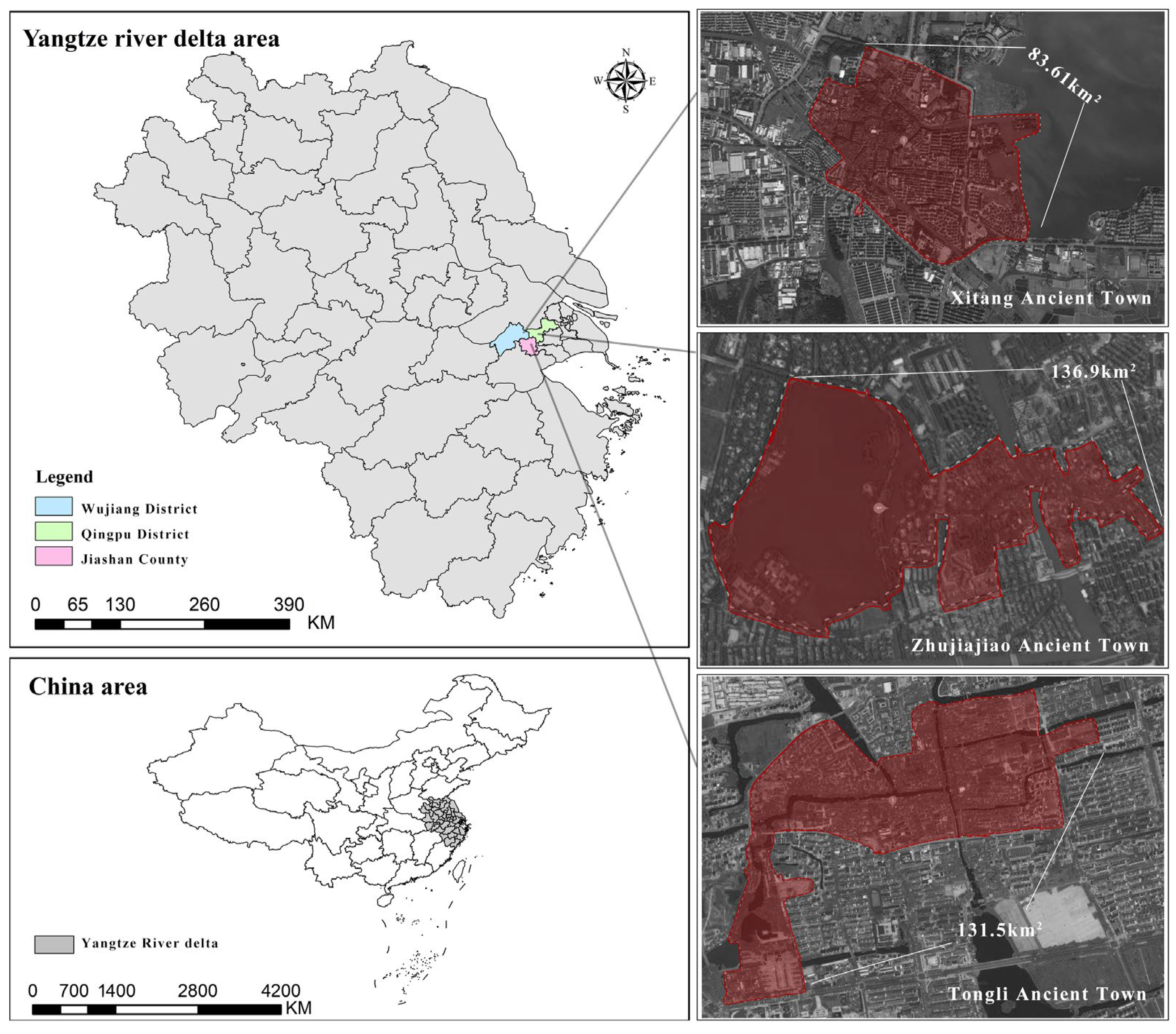
3.1. Study Area

This research focuses on three representative rural areas in the Yangtze River Delta region of China as empirical case studies: Tongli Town in Wujiang District, Suzhou, Jiangsu Province; Xitang Town in Jiaxing, Zhejiang Province; and Zhujiajiao Town in Qingpu District, Shanghai (Figure 1). In the Chinese administrative system, towns represent a primary level of administrative division and house various government agencies. These towns serve as rural areas, comprising multiple villages. In urban regions, the equivalent administrative division to towns is the sub-district office, which consists of several communities at the sub-district level. Towns encompass both natural scenery and culturally significant landscapes resulting from human activities, including traditional villages, farmhouses, countryside stages, and rural public art. Geographically, the three towns are situated in adjacent county-level administrative areas, each belonging to distinct provincial jurisdictions. Strategically, while the three towns fall under different administrative jurisdictions, they are integrated within a national policy framework for coordinated development in the Yangtze River Delta region. From the perspective of cultural customs, the three towns are located within China’s Wu cultural area [101], sharing linguistic and traditional similarities while exhibiting profound distinctions from other regions of China. The ancient towns of Tongli, Xitang, and Zhujiajiao are exemplary cases for interpreting rural landscape construction in the Yangtze River Delta from ecological, production, and living dimensions. These towns fully embody the ecological foundation of “water network polder fields”, the living pattern of “water–land symbiosis”, and the productive model of “agricultural, cultural, and tourism integration”. Representing wetland conservation, cultural consumption, and urban–rural symbiosis development paths, respectively, their differentiated practices offer diverse paradigms for regional rural revitalization. The current status of their ecological–production–living landscapes is as follows. This selection provides a comparative framework for understanding the multifaceted approaches to sustainable rural development in the region.

3.1.1. Ecological Landscape: Commonalities and Divergences in Natural Foundations and Governance Approaches

The ecological landscapes of the three towns are all located in the core area of the Yangtze River Delta, exhibiting minimal differences. Each town relies on the natural foundation of “water network polder fields”, forming an ecological pattern of “parallel rivers and streets, water–land symbiosis”. For instance, Tongli’s waterways and 49 ancient bridges create a complete water system, Xitang’s 9 waterways and 24 stone bridges form an “eight-zone connected” water network, and Zhujiajiao’s Cao River and Dianpu River constitute a “golden waterway”. All three towns maintain the ecological functions of their water bodies through measures such as river dredging and water circulation projects. For example, Tongli has completed ecological restoration for over 20 streets and all waterways, while Zhujiajiao has established a smart river chief system and promoted the remediation of dead-end rivers. Tongli, centered around a national wetland park with a wetland coverage rate of 85.41% [102], features a composite ecosystem of forests, fields, and water networks, emphasizing authenticity and biodiversity in ecological conservation. Xitang focuses on “blue-green intertwined” ecological restoration, such as the garden-style renovation around Xiangfu Lake, which added 360,000 square meters of greenery [103] and integrates natural and cultural landscapes through its “ecological shoreline connectivity project”. Zhujiajiao highlights “urban–rural symbiosis” in ecological governance, balancing agricultural conservation and tourism development through ecological compensation mechanisms, while promoting prefabricated buildings and green energy applications, resulting in a more composite ecological landscape characteristic of urban suburbs.

3.1.2. Living Landscape: Tensions and Adaptations in Traditional Continuity and Modern Transformation

All three towns preserve the classic Jiangnan architectural style of “white walls and black tiles with small bridges and flowing water”, while emphasizing dynamic conservation. For example, Tongli adheres to the principle of “repairing the old as it was” to restore cultural heritage sites like the Tuisi Garden, Xitang authentically preserves 16 intangible cultural heritage items such as field songs and paper-cutting, and Zhujiajiao maintains the commercial-residential layout of “streets in front and rivers behind”. Each town employs smart management systems, such as Tongli’s “Smart Ancient Town” and Xitang’s “Digital Twin”, to enhance residents’ quality of life. Tongli, with around 12,000 indigenous residents, centers its living landscape on “traditional water town life”, preserving folk activities like lianxiang dancing, with high community engagement. Xitang, the most commercialized, retains daytime scenes such as riverside laundry and teahouse performances, while transforming into a modern entertainment hub at night with its “moonlight economy”, featuring light corridors and live music. Zhujiajiao fosters strong interactions between locals and tourists through experiences like traditional letter-writing at the Qing Dynasty Post Office and making Apo Zongzi (glutinous rice dumplings), though commercial activities pose some challenges to the authenticity of daily life.

3.1.3. Productive Landscape: Circulation and Integration of Industrial Models and Cultural Assets
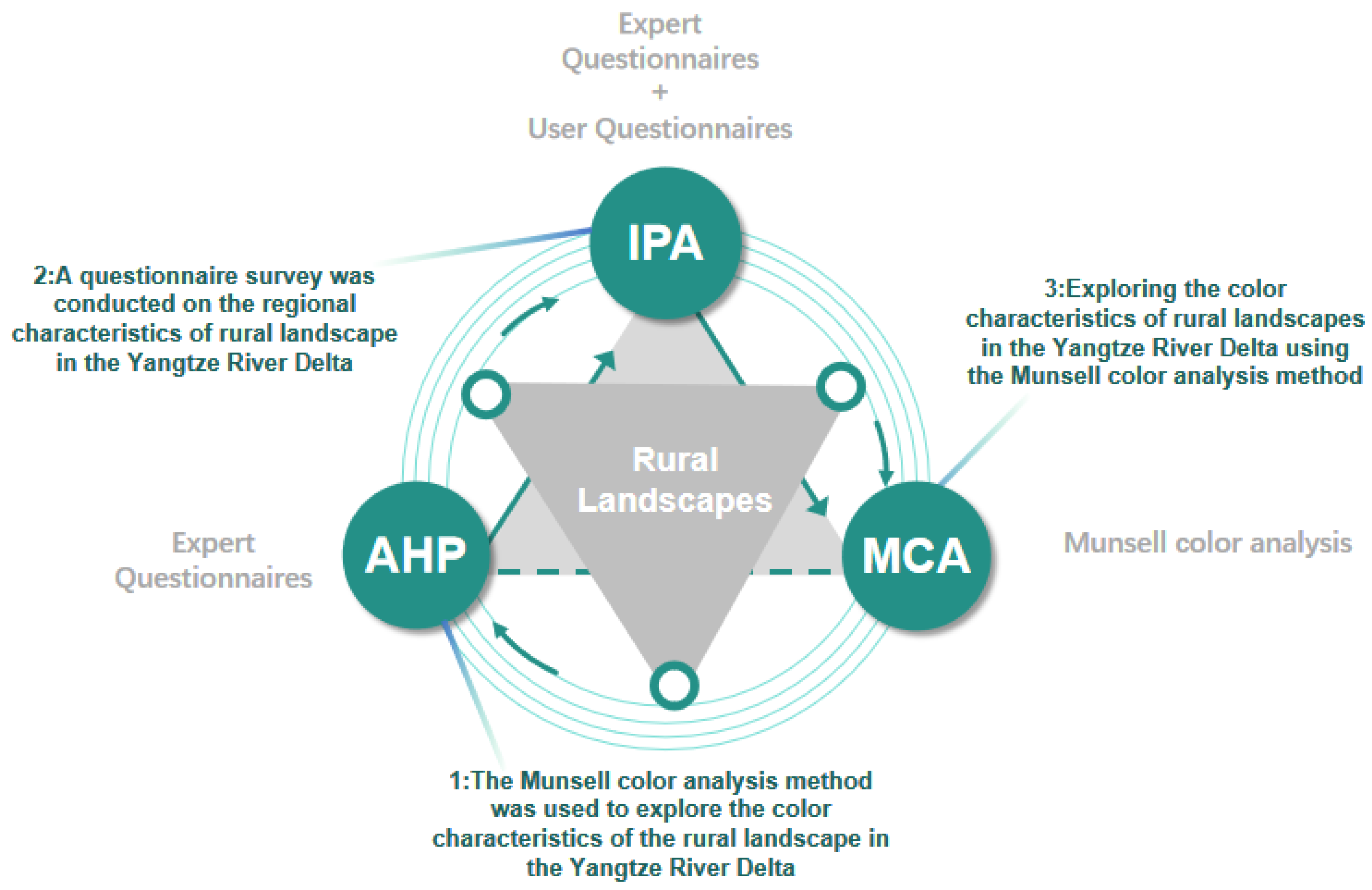
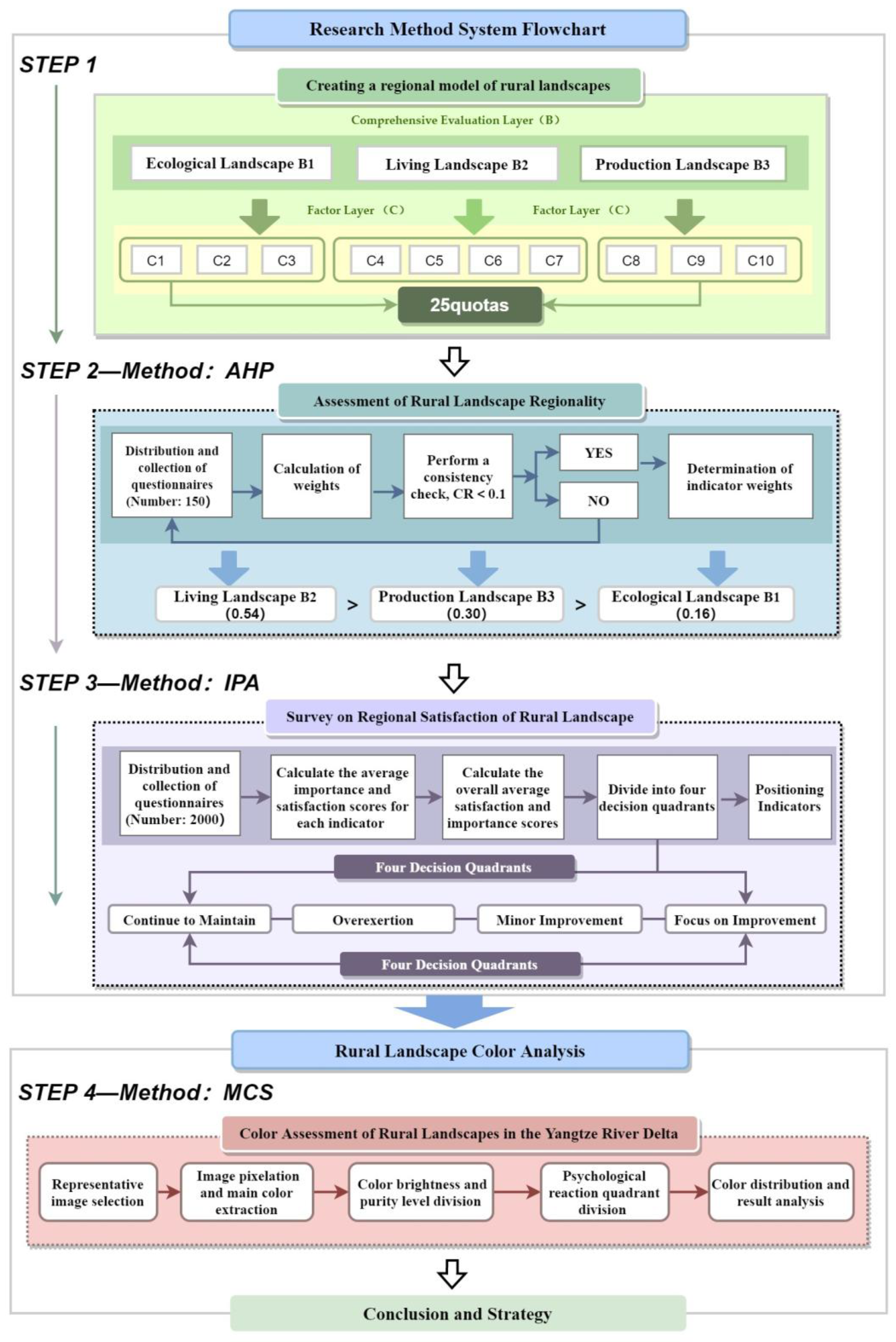
From the perspective of productive landscapes, all three towns have developed production chains that transform cultural heritage into tourism consumption. For instance, Tongli leverages cultural heritage sites like the Tuisi Garden to promote educational tourism, Xitang has created a national cultural tourism IP through its Hanfu Culture Week, and Zhujiajiao positions itself as a “world vacation hub” to develop business tourism. Each town emphasizes the revitalization of traditional handicrafts, such as embroidery in Tongli, indigo dyeing in Xitang, and pickle-making in Zhujiajiao. Tongli’s productive landscape features a composite model of “agriculture + culture”, preserving traditional farming practices like rice cultivation while transforming intangible cultural heritage through spaces like the “Water Town Wedding Customs Museum”. Xitang is characterized by “tourism + cultural creativity”, with immersive experiences like “Jiangnan Hundred Scenes” and an extended Hanfu industry chain, showcasing a youthful and trendy productive landscape. Zhujiajiao stands out for its diverse business and leisure activities, adopting a “small scenic areas + self-operated events” model after eliminating entrance fees to attract business clientele. It also integrates modern industries like biopharmaceuticals and sports, reflecting the highest degree of urbanized integration in its productive landscape.
Overall, Tongli, Zhujiajiao, and Xitang, as typical water town settlements in the Yangtze River Delta, share common ecological–production–living landscape features rooted in water town culture. However, they also exhibit certain divergences due to differences in geographical location and development paths (Table 1). In terms of ecological landscapes, all three towns are situated in the same geographic region, characterized by flat terrain and a crisscrossing water network typical of the Yangtze River Delta. Regarding living landscapes, they all embody a cultural atmosphere of “valuing commerce and emphasizing literature”, preserving the intrinsic cultural ambiance of “small bridges, flowing water, and households” in the region. From the perspective of productive landscapes, tourism and agriculture are highly developed in all three towns, reflecting a well-balanced state of ecological–production–living landscapes. These characteristics make them representative and exemplary cases within the Yangtze River Delta region.

3.2. Study Design

Initially, a rural landscape indicator evaluation system is constructed from the “production–living–ecology” perspective, employing the AHP to assess the significance of various rural landscape elements. Subsequently, a questionnaire survey is administered to evaluate visitor satisfaction regarding the regional characteristics of the triangular rural landscape, and the results are integrated with the findings from the layer analysis method to analyze the importance and satisfaction of the rural landscape. Additionally, utilizing the Munsell color analysis method, this study investigates the color characteristics of rural landscapes in the Yangtze River Delta. Finally, based on the results of the preceding research, strategic recommendations for the construction of rural landscapes are presented. The research structure is depicted in Figure 2. The flowchart of the research methodology system is shown in Figure 3.

3.2.1. Assessment of Rural Landscape Regionality

Research on rural landscapes began in the 1960s in countries such as the United Kingdom and the United States [104]. For instance, the UK developed a rural evaluation system in response to the 1986 Countryside Act, emphasizing that evaluation before design is an effective method for protecting rural landscapes. In the 1990s, British landscape scholar Bacon argued that landscape evaluation should focus on conservation value, landscape resources, aesthetic value, and spatial integrity. The United States established natural resource landscape evaluation systems in 1979 and 1986 [105]. Korean scholar Sung utilized Artificial Neural Networks (ANN) and Geographic Information Systems (GIS) to evaluate mountain landscapes [106]. German researcher Steinhardt applied fuzzy judgment theory and hierarchical methods to evaluate landscape cases [107]. Gulinck constructed a landscape evaluation framework based on visuality, integrity, and diversity, applying it to practical cases [108]. Czech scholars Miklos and Ruzicka proposed a landscape ecological planning method [109], encompassing ecological evaluation, landscape ecological analysis, landscape components, and practical recommendations, which has been well-received. These studies collectively highlight the evolution and diversity of approaches in rural landscape evaluation and planning.
Research in China started later, but in recent years, many scholars have proposed evaluation systems and methods for rural landscapes to provide reliable solutions for landscape planning, protection, and sustainable development. Liu Binyi et al. (2002) developed a landscape evaluation system based on five levels and 21 indicators, including compatibility, sensitivity, accessibility, and scenic beauty of rural landscapes [110]. Chen Wei (2007) introduced the AVC comprehensive evaluation system for rural landscapes, focusing on three target layers: vitality, attractiveness, and carrying capacity [111]. Ding Wei (1994) established a rural landscape ecological evaluation system based on the ecological environment assessment of Haimen County, Nantong, incorporating 36 indicators across three systems: agricultural production, rural industry, and residential life [17]. Xiao Duning (1998) proposed criteria for landscape ecological evaluation, including uniqueness, diversity, livability, functionality, and aesthetic value [112]. Liu Liming (2003) constructed a rural landscape evaluation system using three dimensions: aesthetic effect, ecological quality, and social impact [21]. Lu Bingyou (2001) built a landscape ecological evaluation system from four perspectives: ecology, resources, society, and economy of agricultural landscapes [113]. These studies collectively reflect the growing emphasis on comprehensive and multidimensional approaches to rural landscape evaluation in China.
The AHP is a multi-criteria decision-making approach introduced by T.L. Saaty in the 1980s, which combines qualitative and quantitative analysis systems [114]. The AHP method compares and ranks items according to established criteria and gathers respondents’ preferences via surveys to evaluate the relative importance of these items. A hierarchical structure is created through pairwise comparisons, leading to the determination of the optimal solution.
This paper, drawing on extensive historical and cultural materials related to the Yangtze River Delta, constructs a rural landscape evaluation system for Jiangnan from the perspective of ecological–production–living landscapes. It builds upon Liu Shilin’s (2011) classification of Jiangnan cultural resources [115] and references Professor Zhou Wuzhong’s Neo-Ruralism theory [116], which emphasizes the harmony of ecology, living, and production. Additionally, it incorporates domestic and international rural landscape evaluation indicators. The evaluation system is designed based on the following three principles: (1) The indicators should reflect the essence and developmental patterns of Yangtze River Delta culture; (2) the content of each indicator should embody the ecological and regional characteristics of the Yangtze River Delta rural landscapes; (3) the indicator system should integrate the industries and industrial chains of the Yangtze River Delta rural areas. This approach ensures a comprehensive and culturally grounded framework for evaluating rural landscapes in the region.
Therefore, this research will utilize the AHP methodology to develop a rural landscape evaluation system from the perspectives of ecological, production, and living spaces. The evaluation criteria and content for various goal layers will be represented through four hierarchical levels: A (Goal Layer), B (Factor Layer), C (Indicator Layer), and D (Sub-Indicator Element Layer). The A layer constitutes the rural landscape evaluation framework. The B layer classifies the landscapes into ecological, production, and living categories. The C layer further classifies ecological landscapes into topographical and geomorphological, climatic, and biodiversity landscapes; living landscapes into architectural, folk, culinary, and spiritual landscapes; and production landscapes into agricultural, industrial, and tourism landscapes. The D layer is detailed based on the preceding factor layer, culminating in a total of 25 sub-indicators. Based on the aforementioned standards, this establishes the evaluation model tree for rural landscapes in the Yangtze River Delta (Table 2).
The significance of the model tree is evaluated on a 9-point scale. The AHP questionnaire is expected to distribute 150 copies, comprising 50 to doctoral candidates in design-related disciplines, 50 to university educators in design fields, and 50 to personnel from relevant government agencies in the three towns. The mean scores of the selected experimental subjects will be utilized to outline the relative importance scale values among the factors, and SPSS 22. will be employed for weight calculations. The formula for calculating weights is as follows:
T i = k = 1 n X i k n i = 1,2 , , n
In the equation, n refers to the number of evaluation factors; X i k ( i = 1, 2, …, n) is the value derived from the comparison of the relative importance between the i factor and the k factor. Consequently, the weight value Q i of each evaluation factor relative to the A goal layer can be determined, as expressed in the following formula:
Q i = T i i = 1 n T i i = 1,2 , , n
The maximum eigenvalue is
λ m a x = i = 1 n 1 n Q i i = 1 n X i j Q j
And a consistency check is performed; the formula is
C I = λ m a x n n 1

3.2.2. Questionnaire Survey on Rural Landscape Satisfaction

This study will conduct a questionnaire survey to assess the satisfaction levels of rural landscapes in the three towns. The survey will reference the Visual Resources Management (VRM) questionnaire, a landscape evaluation method developed by the Bureau of Land Management of the U.S. Department of the Interior for assessing the value of land landscapes. This research modifies the VRM system by incorporating two additional layers into the evaluation structure, categorizing the options into five categories: “Very Satisfied”, “Satisfied”, “Neutral”, “Unsatisfied”, and “Very Unsatisfied”. To assist respondents in indicating their attitudes, each indicator will be explicitly described using these five attitude categories.
This paper conducted a reliability analysis on the questionnaire using SPSS software, specifically employing the Cronbach’s alpha reliability coefficient method to test the consistency of the questions. The formula is as follows:
α = n n 1 1 S i 2 S T 2
In this formula, n represents the total number of questions in the scale, S i 2 denotes the variance of scores for the i-th question, and S T 2 is the variance of the total scores across all questions. In addition to the qualitative questionnaire content of questions 1–16, a reliability analysis was conducted on the comprehensive satisfaction scores for the 25 indicators of ecological–production–living landscapes in question 17. The results are as follows:
The overall reliability of the questionnaire exceeds 0.7 (Table 3), while the reliability for the evaluation of ecological–production–living landscape indicators is 0.967 (Table 4). This demonstrates that the questionnaire has high reliability in evaluating rural landscapes in the Yangtze River Delta and assessing ecological–production–living landscape indicators.
A reliability analysis of the items in the overall questionnaire yielded the following results:
In terms of questionnaire validity, among the respondents, 57.58% were female and 42.42% were male. The majority had an educational level of bachelor’s degree or higher, with the most common income range being CNY 10,000 to 20,000. Most tourists were from Jiangsu, Shanghai, Zhejiang, and Anhui, with a significant portion being government and corporate employees. The rural tourism attractions drew a highly educated demographic, predominantly consisting of nearby tourists and residents. This indicates that the sample is representative of the target population, enhancing the validity of the questionnaire results.
The detailed content of the rural landscape satisfaction survey questionnaire aligns with the D-level indicators of the AHP questionnaire. The questionnaire survey was conducted in an online format, utilizing the Questionnaire Star function available in the WeChat mobile app. The plan was to distribute 2000 online survey questionnaires, with distribution scheduled for the year 2024.

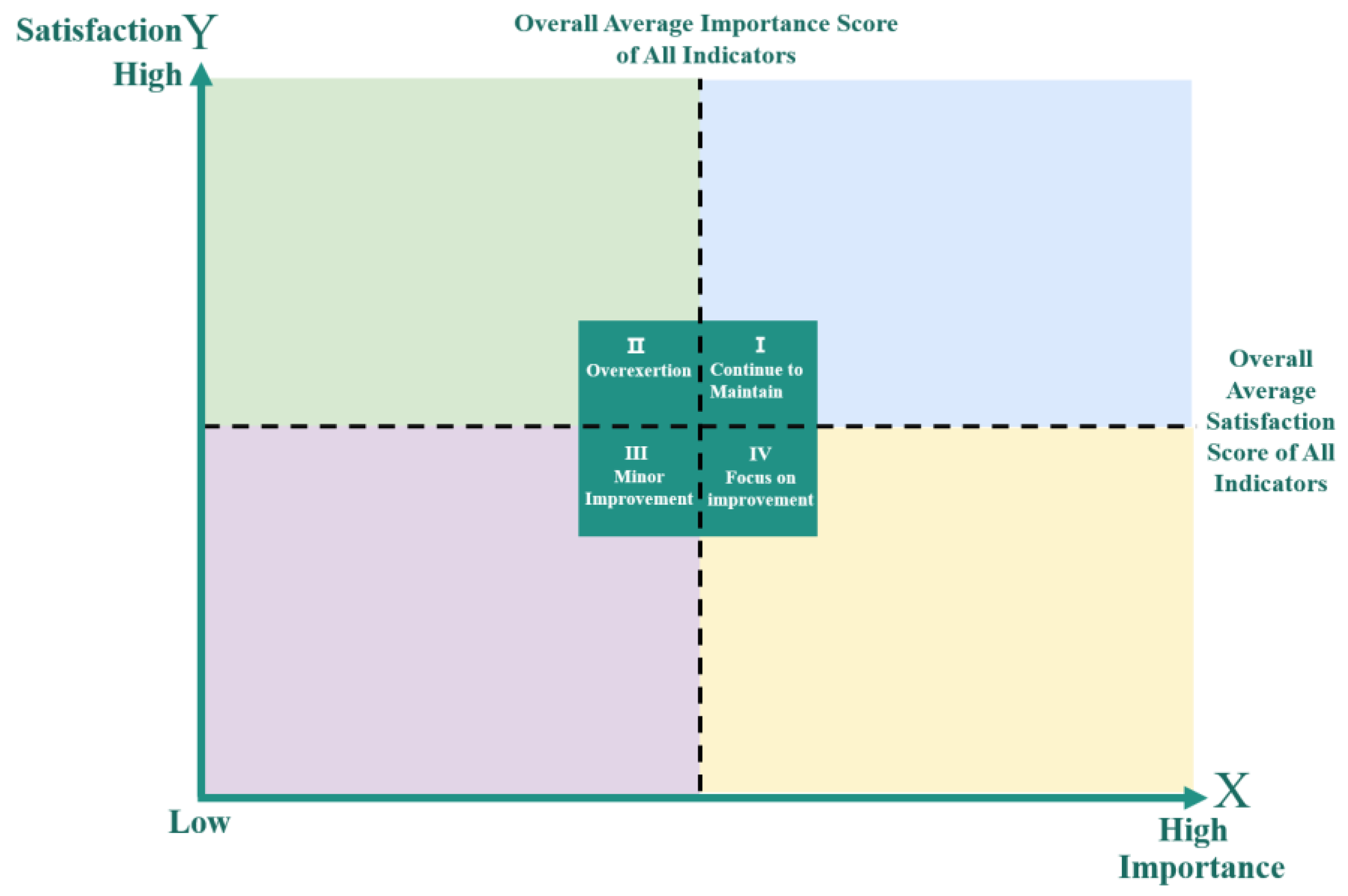
3.2.3. IPA of the Importance and Satisfaction Levels of Rural Landscape Regionality

This research utilizes the Importance-Performance Analysis (IPA) method to investigate the relationship between the importance and satisfaction levels of rural landscapes from the perspectives of production, living, and ecology. The IPA method is a commonly applied survey analysis technique for integrated evaluation, known for its objectivity and clarity.
In the IPA, the X-axis denotes the importance scores of the indicators, while the Y-axis indicates the satisfaction scores of the indicators. The importance values are plotted on the X-axis and the satisfaction values on the Y-axis, with the intersection of the X and Y axes serving as the origin, forming quadrants in the coordinate system. The operational procedure for IPA is outlined as follows: The initial step involves calculating the average importance score and the average satisfaction score for each indicator. The second step involves calculating the total average importance score and the total average satisfaction score for all indicators. The third step involves using the total average importance score of all indicators as the dividing point for the X-axis and the total average satisfaction score of all indicators as the dividing point for the Y-axis, distinguishing the quadrants into four areas: “Continue to Maintain”, “Focus on Improvement”, “Minor Improvement”, and “Overexertion” (Figure 4). The fourth step involves positioning each indicator in the appropriate area according to its average importance score and average satisfaction score.
This study’s IPA consists of 25 indicators. These 25 indicators correspond to the “Sub-factor Layer D” in the AHP and align with the rural landscape evaluation questionnaire. In the IPA, the X-axis denotes the importance of rural landscapes, and the values on the X-axis will utilize the weights of each indicator from the AHP in the regional evaluation of rural landscapes. The Y-axis indicates the satisfaction level of rural landscapes, with the values on the Y-axis derived from the results of the rural landscape evaluation questionnaire. To facilitate calculations, the satisfaction survey for rural landscapes will undergo value assignment. In the rural landscape evaluation questionnaire, the scoring is as follows: “Very Satisfied” receives five points, “Satisfied” receives four points, “Neutral” receives three points, “Unsatisfied” receives two points, and “Very Unsatisfied” receives one point.

3.2.4. Evaluation of Rural Landscape Colors

Using the IPA (Importance-Performance Analysis) results for the ecological, production, and living landscapes, factors that most require improvement (focus on improvement) and those that perform best (Continue to Maintain) were selected for color analysis. This approach ensures a balanced strategy of leveraging strengths and addressing weaknesses in future landscape design. The focus on improvement, which are areas of utmost importance but that received the lowest satisfaction levels, warrant particular attention. If these factors include multiple indicators, the top three most critical elements are prioritized for in-depth analysis and improvement. Similarly, the Continue to Maintain factors are also analyzed to ensure their sustained performance. This method ensures that landscape design is targeted and effective, addressing key areas for enhancement while maintaining existing strengths.
This research will investigate the color features of Tongli Town in Suzhou, Xitang Town in Hangzhou, and Zhujiajiao Town in Shanghai through Munsell color analysis, along with the factors affecting these color characteristics. The Munsell Color System (MCS) is a color classification and notation system established in 1905 by American artist and educator A.H. Munsell, aimed at standardizing and quantifying colors for more accurate description, classification, and identification. The Munsell Color System consists of three fundamental components: hue, value, and chroma. Hue denotes the basic property of color. The Munsell system divides hue into 10 levels, comprising five primary hues (red, yellow, green, blue, and purple) and five intermediate hues (yellow-red, green-yellow, blue-green, purple-blue, and red-purple). Various hues within the Munsell Color System can evoke distinct visual experiences and emotional reactions.
The procedure for assessing the colors of rural landscapes is outlined below. Initially, representative images of rural landscapes are selected (Figure 5a, Figure 6a and Figure 7a). These images undergo pixelation to extract the dominant colors(Figure 5b, Figure 6b and Figure 7b), which are then organized by brightness to determine the main color composition of the rural landscape (Figure 5c, Figure 6c and Figure 7c). Subsequently, color brightness and purity are divided into four quadrants according to the psychological responses they elicit at varying levels of brightness and purity. Ultimately, the extracted colors are placed in the quadrants based on their brightness and purity (Figure 8a). The concentration of color points provides insights into the overall psychological impact of the rural landscape (Figure 8b). To ensure a balanced perspective on production, ecology, and daily life, photos were selected according to the classification of this study. For ecological landscapes, three photos each of topography, climatic features, and biodiversity were chosen. For living landscapes, three photos each of architecture, local lodgings, cuisine, and spiritual landscapes were selected. For productive landscapes, three photos each of agriculture, industry, and tourism were included. These photos were pixelated using Photoshop, and SPSS software was used to statistically analyze the 20 dominant colors from the pixel data, thereby determining the primary color palette of the rural landscapes (Figure 5, Figure 6, Figure 7 and Figure 8). The following color analysis method is illustrated using photos taken by the research team in rural areas of the Yangtze River Delta.

4. Results

4.1. Topography, Architectural Landscapes, and Tourism Landscapes Are the Most Critical Factors Within the Ecological, Production and Living Landscapes

According to the results of the AHP questionnaire, the living landscape serves as the primary indicator of rural landscape regionality, followed by the production landscape and the ecological landscape (Table 5). At the indicator level, topography and geomorphology are identified as the most critical aspects of the ecological landscape, while the architectural landscape predominates in the living landscape. Additionally, the tourism landscape is the most significant component of the production landscape. Among the 25 specific indicators, key factors include traditional dwellings, historical relics, signage design, rural nightscapes, and public art design. From an ecological landscape perspective, the Yangtze River Delta region exhibits pronounced water network features, which significantly represent its regional identity. The flora and fauna are inherently regional, making plant and fauna landscapes vital representations of regional characteristics and placing them in a relatively prominent position. In terms of living landscape characteristics, traditional dwellings and historical relics serve as core elements in expressing the regional identity of rural landscapes in the Yangtze River Delta. Regarding production landscape characteristics, public art design and signage design play crucial roles, emphasizing that artistic aesthetics are primary objectives of rural landscapes in the Yangtze River Delta. This focus aligns closely with the implementation of China’s rural revitalization strategy, particularly concerning the growth of rural tourism.

4.2. Certain Factors in the Living and Productive Landscapes Require Improvement in Satisfaction Levels

This study ultimately collected 1983 valid questionnaires. The survey results indicated that respondents expressed a high degree of satisfaction with rural landscapes overall (Table 6). Among the individual survey items, “satisfied” was the most frequently selected option, followed by “neutral”, “very satisfied”, “dissatisfied”, and “very dissatisfied”. The combined proportion of respondents selecting “dissatisfied” and “very dissatisfied” across all items was less than 4%. However, approximately 30% of respondents rated their satisfaction with rural landscapes as “neutral”.
The questionnaire indicates that the rural ecological environment is the most significant appeal of rural landscapes and the key feature that distinguishes them from urban landscapes. The rural landscapes in the Yangtze River Delta are rich in cultural significance, with their poetic charm and iconic imagery of small bridges, flowing streams, and homes creating a distinct regional impression. The natural rural landscapes of the Yangtze River Delta receive high satisfaction ratings, particularly the water network-based ecological landscapes, which should be emphasized in future planning to develop water-themed ecological landscapes representative of the region. Future planning and design should prioritize enhancing the design of traditional dwellings, historical relics, signage design, handicrafts ornaments, and village exhibition spaces.

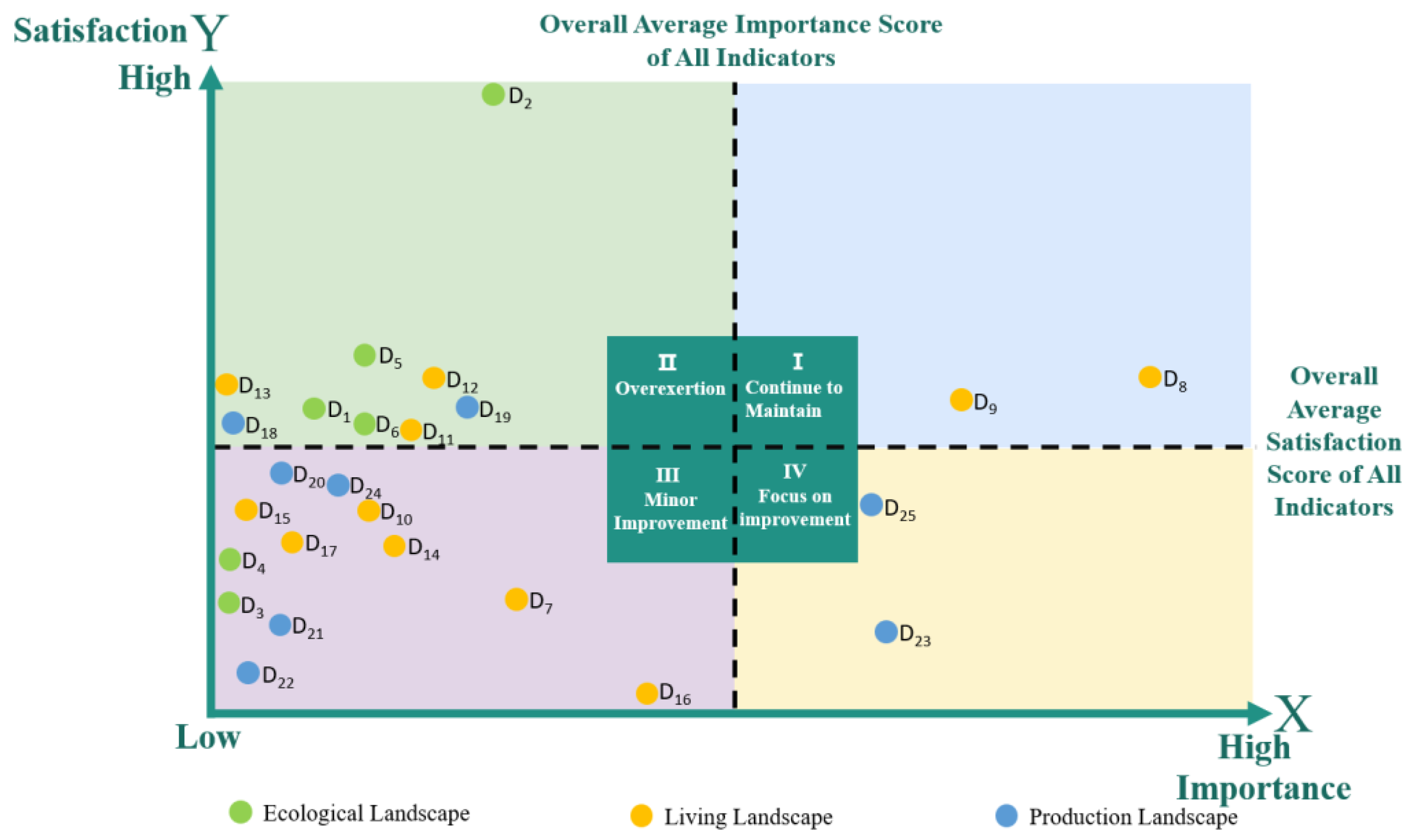
4.3. The IPA (Importance-Performance Analysis) Indicates That Most Indicators Are in a Good State, While a Small Number of Indicators in the Productive Landscape Urgently Require Improvement

According to the results of the IPA (Figure 9), out of the 25 indicators, two are categorized as “Maintain Performance”, specifically historical relics and traditional dwellings. Nine indicators are classified as “Over-Exertion”, namely water network landscapes, plant landscapes, mountain landscapes fauna landscapes, regional vernaculars, village feast traditions, seasonal folk customs, agricultural products, and agricultural planting areas. Twelve indicators are categorized as “Secondary Improvement”, including temperature and humidity conditions, rainy season landscapes, village exhibition space, soral literature, traditional performing arts, regional culinary specialties, spatial layout, traditional belief systems, product processing facilities, rural nightscapes, industrial buildings, and handicraft ornaments. Two indicators are classified as “Key Improvement”, specifically public art design and signage design. The “Maintain Performance” category contains fewer indicators, while the “Secondary Improvement” category encompasses the most, suggesting that the regional characteristics of rural landscapes still have room for enhancement.

4.4. The Design of Ecological–Production–Living Landscapes Needs to Focus on Several Key Color Factors

By conducting a color evaluation of key factors in the ecological–production–living landscapes of the three ancient towns, the factors requiring focused attention are identified as follows: the water network landscape in ecological landscapes, traditional dwellings, and historical relics in living landscapes, and signage design and public art in productive landscapes.
First, the water network landscape received the highest satisfaction score in the IPA, which is directly linked to the well-developed water systems in the Yangtze River Delta rural areas. Each ancient town has created a series of waterfront landscapes around its water networks, and the ambiance of small bridges, flowing water, and households has become a major attraction for tourists and a signature feature of the region. The mature development of water network landscapes allows for color analysis to identify their dominant color characteristics, which can then be referenced in the design of water network landscapes in other rural areas.
Second, the IPA results show that traditional dwellings and historical relics in the living landscapes also achieved high satisfaction and high importance, making them the most well-developed factors in the three ancient towns. Due to the effective preservation of ancient town buildings and their subsequent commercial development, many ancestral halls and former residences have been well-maintained. Analyzing the colors of these buildings provides critical design insights for the inheritance and protection of traditional architecture in the Yangtze River Delta rural areas.
Third, rural signage design and public art are identified as factors in urgent need of improvement. Color analysis can determine whether these elements lack vitality. As seen in the earlier color analysis of the Yangtze River Delta, most rural colors tend to be steady and tranquil, with vibrant colors primarily coming from tourism landscapes, which create an enthusiastic atmosphere and enhance visitor experiences, thereby stimulating consumption. Signage design plays a crucial role in guiding human flow in urban and rural spaces, necessitating the use of warm and lively colors to empower its function.

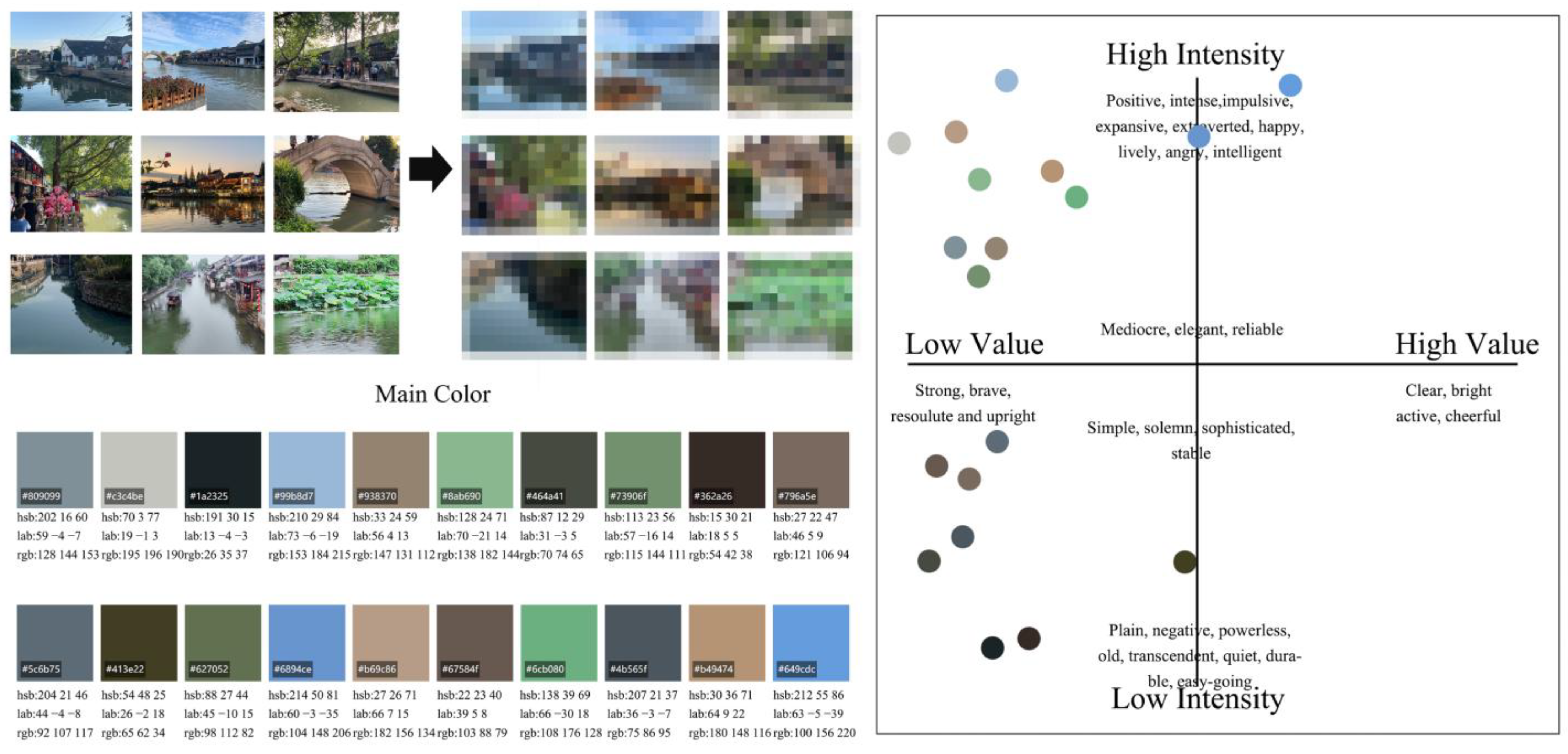
4.4.1. Color Analysis of the Water Network Landscape in Ecological Landscapes

The primary colors of the water network landscape are evenly split between high-purity, low-brightness tones, and low-purity, low-brightness tones (Figure 10). Overall, the palette tends toward darker shades. This is primarily due to the brickwork (RGB 121, 106, 94) of the embankments and arched bridges, which are constructed using local materials. Additionally, the presence of moss and other aquatic plants on these materials contributes to the darker colors near the shore (RGB 26, 35, 37). Most ancient towns retain traditional wooden structures, resulting in darker hues for waterfront buildings (RGB 54, 42, 38). These color characteristics provide valuable design references for the renovation of waterfront structures in the Yangtze River Delta rural areas. The water network landscape also features numerous plants along the banks, predominantly evergreen species with minimal seasonal variation, whose colors mainly fall within the high-purity, low-brightness quadrant (RGB 138, 182, 144; RGB 115, 144, 111; RGB 98, 112, 82; RGB 108, 176, 128). The water quality in the three ancient towns is excellent, with some high-purity, low-brightness colors representing the inherent colors of the water (RGB 128, 144, 153) and reflections of the sky (RGB 153, 184, 215; RGB 104, 148, 206). This color combination creates a comfortable rural environment.

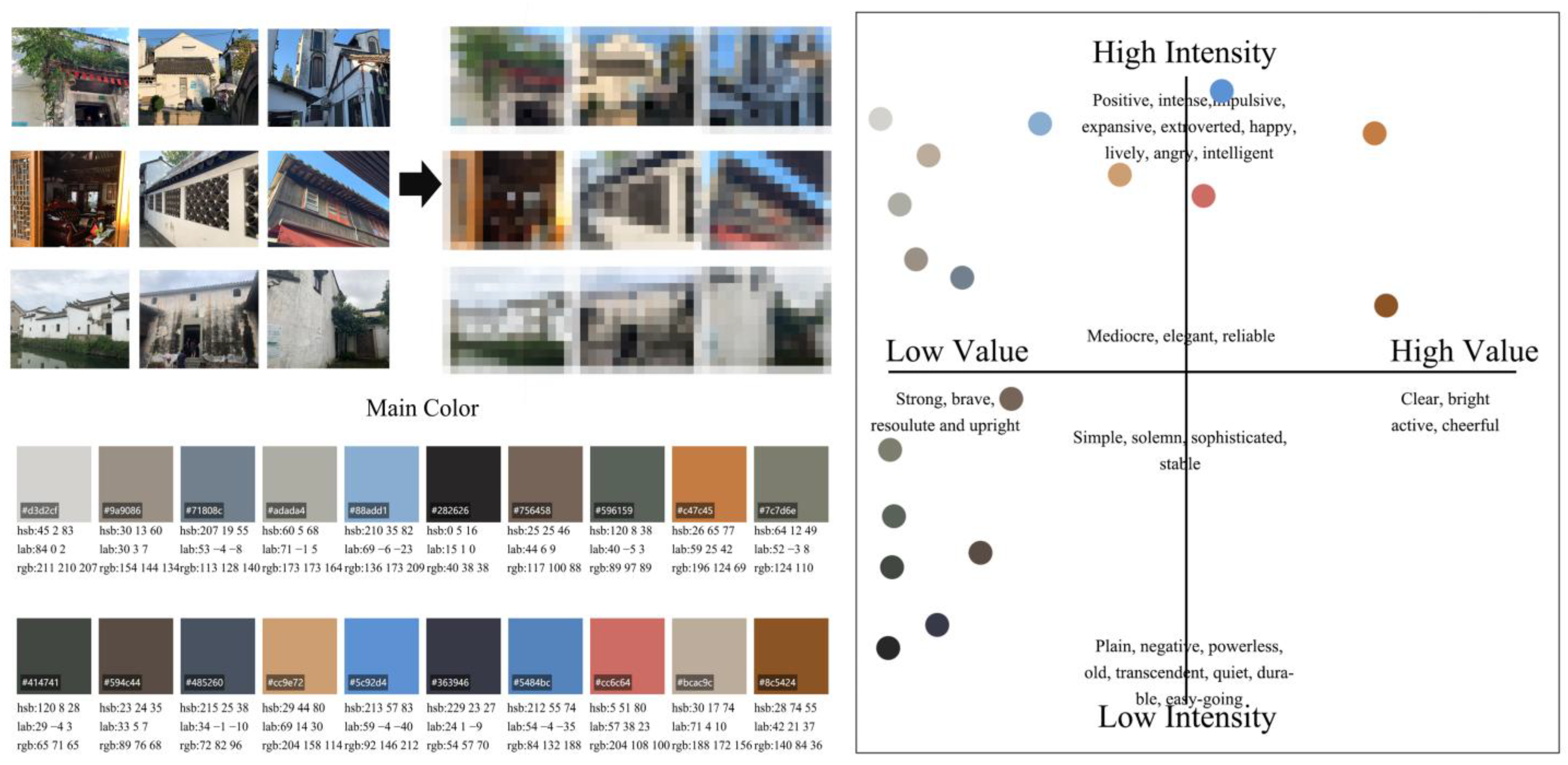
4.4.2. Traditional Dwellings and Historical Relics Are in a Relatively Good Condition

In the IPA, the color performance of traditional dwellings and historical relics falls within the “maintain the status quo” quadrant. The color distribution exhibits a dual characteristic of “stable base with vibrant accents”, aligning with the cultural aesthetics of the Yangtze River Delta rural areas, which emphasize “low-key restraint as the main theme, complemented by festive vitality” (Figure 11). Traditional architectural colors are concentrated in the low-brightness, low-purity range (RGB 89, 76, 68; RGB 54, 57, 70; RGB 40, 38, 38). Among these, the blue brick walls (RGB 173, 173, 164) and original wooden frames (RGB 196, 124, 69) form a low-purity, low-brightness base, reflecting the material heritage of the “white walls and black tiles” tradition. A small portion of accent colors are distributed in the high-purity, high-brightness range, typical examples being festive lanterns (RGB 204, 108, 100) and decorations (RGB 140, 84, 36), with their area strictly controlled within 10%, adhering to the “60-30-10” color harmony principle [117]. The color strategy for the dwellings and historical relics in the three ancient towns injects vitality into daily life while maintaining historical authenticity. The dark-tone base effectively connects with the blue-gray system of the water network landscape, creating visual continuity of “land and water in harmony”. High-saturation accent colors, through positional constraints and brightness buffering, avoid disrupting the traditional atmosphere, resulting in a well-balanced living landscape effect.

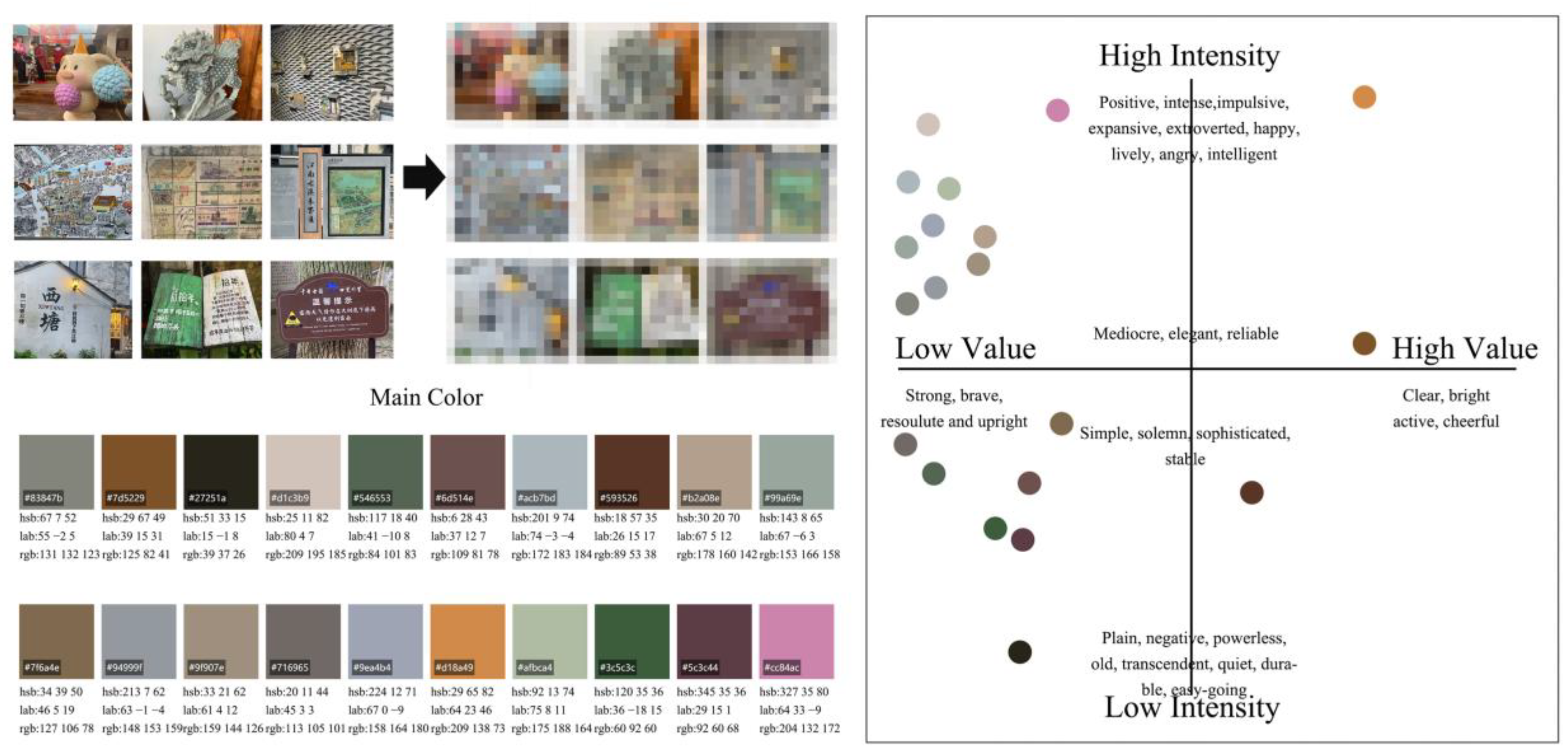
4.4.3. Signage Design and Public Art Lack Vitality

In the IPA, the color performance of signage design and public art falls within the quadrant requiring urgent improvement. The color characteristics of rural signage and public art design resemble those of the water network landscape, residential landscapes, and historical relics, with most colors concentrated in the high-purity, low-brightness, and low-purity, low-brightness ranges (RGB 39, 37, 26; RGB 127, 106, 78). Only a small number of cultural and creative artworks (RGB 204, 132, 172) and signage (RGB 209, 138, 73) evoke a warm and positive attitude among tourists (Figure 12). Most sculptures in the three ancient towns are stone carvings (RGB 158, 164, 180), with colors leaning toward steadiness. The color vibrancy of directional signs and maps is relatively low (RGB 109, 81, 78; RGB 89, 53, 38; RGB 92, 60, 68), failing to create effective visual stimulation. The alignment of IPA results with survey data reveals that such designs have not fulfilled the dual roles of guiding function and cultural expression. There is an urgent need for optimization through enhanced color contrast and strengthened regional symbols.
From the perspective of key factors requiring improvement, the water network landscape in ecological landscapes received the highest evaluation, indicating that the three ancient towns have achieved significant success in rural ecological protection. Their plant combination methods can be applied to the construction of ecological landscapes in other rural areas. Traditional dwellings and historical relics in the living and productive landscapes showed favorable results, suggesting that the color application of traditional architecture in the three ancient towns has gained public recognition, providing valuable experience for other rural areas in the Yangtze River Delta. However, signage design and public art, despite sharing similar color schemes with architectural colors, did not achieve satisfactory outcomes. The colors of these factors failed to attract significant attention from tourists, necessitating targeted improvements in future landscape designs.

5. Discussion

The current homogenization of rural landscapes highlights the insufficient attention paid by mainstream academic research paradigms to the representation of regional culture and ecological synergy mechanisms. Based on the IPA’s identification of key factors in ecological–production–living landscapes and the empirical analysis of color geography, this study reveals the strengths and weaknesses of rural landscapes in the Yangtze River Delta in terms of ecological connectivity and seasonal color richness of farmland. The IPA results clarify the priorities for systemic ecological protection and the value transformation of productive landscapes, while color analysis quantifies the explicit pathways for expressing regional characteristics from the perspectives of visual perception and cultural representation. Building on this, the study further focuses on the internal functions of the three landscapes: the inherent fragility of ecological landscapes, the erosion of authenticity in living landscapes, and the disconnection in the value chain of productive landscapes. Subsequent discussions will center on these strengths and weaknesses, integrating landscape ecology and cultural semiotics theories to propose a targeted design framework that balances ecological resilience, cultural distinctiveness, and industrial efficiency. This provides an empirically grounded theoretical foundation for addressing the challenge of rural landscape homogenization.

5.1. Ecological Landscapes Need to Maintain Their Strengths While Fostering Innovation

This study proposes a problem-oriented design strategy based on IPA and color perception theory. In the dimension of ecological landscapes, the quadrant distribution of “overconsumption” and “secondary improvement” revealed by IPA results fundamentally reflects the ecological fragility of natural landscapes and the adaptive boundaries of human intervention. Organically formed water networks and mountain landscapes have low response thresholds to high-intensity development, while dynamic elements such as rainy season landscapes offer flexible space for design innovation. In terms of color analysis, the “evergreen base + seasonal accents” color pattern in the Yangtze River Delta rural areas is viewed as a visual mapping of regional ecology and climatic conditions. It emphasizes that color is not merely an aesthetic element but also an explicit expression of ecological adaptability. For instance, the high proportion of native plants like camphor trees is essentially a long-term adaptation to the subtropical humid climate.
The rural landscapes of the Yangtze River Delta exhibit certain advantages in ecological landscapes, which can serve as significant innovation points in landscape design. Based on the findings from the IPA, all ecological landscape metrics are positioned within the “Overexertion” and “secondary improvement” quadrants. Specifically, the development of water network landscapes, plant landscapes, mountain landscapes, and landscapes of fauna excessive effort. This outcome can be attributed to the intrinsic nature of ecological landscapes, which are formed organically and are challenging to modify through human intervention. The “temperature and humidity environment” and “rainy season landscapes” fall under “secondary improvement” initiatives. Consequently, pursuing design innovations specifically for “rainy season landscapes” is a viable option. In terms of color evaluation, ecological landscapes are characterized by vibrant and harmonious colors, primarily high-purity, low-brightness hues. This is particularly evident in the Yangtze River Delta region, where the abundance of evergreen plant species and mild climate are conducive to the growth of camphor trees, osmanthus, magnolias, and broad-leaved trees. The frequent occurrence of rainy seasons enables most plants to thrive, resulting in a landscape that remains verdant throughout the year and serves as a significant source of vibrant colors in rural settings. Large areas of vibrant colors outside the green spectrum should be avoided to prevent disrupting the aesthetic harmony of the overall ecological landscape.
Addressing the current conditions, the strategy for enhancing ecological landscapes emphasizes the adoption of a design philosophy centered on indigenous natural elements. The objective of this strategy is to showcase the distinctive regional characteristics, poetic essence, and sustainability of the rural ecological landscapes in the Yangtze River Delta, aiming to achieve an ideal harmony between humanity and nature. Ecological landscape design should prioritize water elements, creating a “water network landscape system” that embodies the geographical features of the Yangtze River Delta [118]. Bank designs should favor natural ecological forms, extensively utilizing native materials such as wooden piles, local flora, and Taihu stones to promote an environmentally friendly bank appearance. Additionally, it is essential to develop a “plant landscape” that reflects the unique attributes of the Yangtze River Delta, selecting crops and medicinal plants that align with local growth cycles and seasons, ensuring that cultivated and essential farmland remains unharmed, and incorporating native flora for aesthetic enhancement. Furthermore, by integrating the ecological philosophy of “the unity of nature and humanity,” a meticulously designed green landscape can effectively connect water systems with residential structures, fostering a poetic habitat that harmonizes human existence with nature [94]. The design should encompass the planning of rural parks, hiking paths, and landscape streams, leveraging a tree-dominated landscape arrangement to establish an ideal ecological configuration with flowing water in front of homes and dense woodlands behind, thereby achieving a harmonious unity of water, farmland, forests, lakes, and residential environments.
The above practical strategies are essentially the embodied expression of theoretical applications: water network restoration corresponds to the “patch-corridor” theory in landscape ecology, enhancing landscape connectivity through the reconstruction of continuous ecological shorelines; plant layer configuration aligns with the theory of regional color adaptation, transforming climate adaptability into recognizable color symbols; and rainy season landscape design integrates the dynamic concept of “landscape as a process”, making natural hydrological processes the core elements of landscape narratives. These design strategies provide a replicable operational paradigm for addressing the challenges of “over-intervention” and “loss of distinctiveness” in ecological landscape development. Their value extends beyond the Yangtze River Delta, offering reference significance for rural ecological landscape planning in global humid climate regions.

5.2. Living Landscapes Exhibit Typical and Representative Characteristics

After completing the systematic diagnosis and optimization strategy derivation for ecological landscapes, the research perspective shifts to the living dimension within the ecological–production–living landscapes—as the core carrier of rural socio-cultural heritage and residents’ daily experiences, the quality of residential landscapes directly influences place identity and life well-being. IPA results indicate that traditional dwellings and historical relics perform exceptionally well in the evaluation of living landscapes, highlighting the effectiveness of material cultural heritage protection in the Yangtze River Delta region. However, issues such as imbalanced color control in new constructions and insufficient visualization of intangible cultural landscapes have also been exposed. Below, we conduct targeted analysis based on the existing strengths and weaknesses of residential landscapes, integrating color semiotics theory.
The living landscape represents the most culturally distinctive feature of rural areas in the Yangtze River Delta region. It is essential to preserve its inherent state while incorporating strategic chromatic enhancements to enrich its aesthetic and cultural value. This approach not only maintains the authenticity of the rural environment but also elevates its visual appeal, ensuring a harmonious blend of tradition and modernity. Such a practice aligns with the broader goal of sustainable development, where cultural preservation and aesthetic innovation coexist to foster a resilient and vibrant rural identity.
From the perspective of living landscapes, traditional dwellings possess the highest performance in construction evaluations, reflecting significant achievements in the preservation of residential structures in the Yangtze River Delta region and successfully restoring the historical appearance of numerous homes. Additionally, historical relics serve as indicators of high construction standards, demonstrating the effective measures taken by rural areas in the Yangtze River Delta to protect tangible cultural heritage, with most rural sites being well-preserved and becoming significant tourist attractions. Building on this advantage, further improvements can be made to the supporting service facilities for residences and relics to enhance visitor satisfaction. However, the construction status of the majority of other living landscapes is less satisfactory, which may be attributed to excessive rural commercial development. From a color analysis perspective, most rural residences retain their original wooden structural forms, resulting in an overall darker color palette that conveys a sense of stability and subtlety. This aligns with the traditional Chinese cultural pursuit of understated and reserved beauty; therefore, the construction and renovation of traditional residences and historical relics should strive to maintain their original darker hues.
The integration of IPA results and color measurements indicates that the current color strategy has successfully achieved a balance between authenticity preservation and the cultivation of living ambiance. It is recommended to maintain the existing color scheme, predominantly characterized by deep wood tones and bluish-gray hues, with festive colors serving as accents. For newly constructed buildings designed in a traditional style, strict color deviation control should be implemented to ensure the preservation of the historical district’s inherent chromatic impression. In rural areas, vibrant colors are not prevalent, and the overall palette remains dominated by darker tones. The remnants of living landscapes primarily exist in intangible forms, such as folk tales and dialects. When these intangible elements are translated into material forms through design, adherence to this established color style is essential to maintain consistency and cultural coherence. This approach ensures the continuity of the region’s visual identity while respecting its historical and cultural context.
The focus of living landscape design is to embed the aesthetic elements of the Yangtze River Delta into rural architectural spaces, centering on the expression of the region’s inherent cultural beauty, which involves the organic integration of culturally significant symbols into rural living environments. Based on the landscape evaluation findings for rural areas in the Yangtze River Delta, traditional dwellings and historical relics are pivotal components of the existing rural landscape. Designing complementary buildings around these residences, such as rain shelters, can help create a “corridor system” that enables villagers to engage in daily communication and material exchanges during inclement weather and festive occasions. As important gateways for rural areas to present themselves in the new era and mitigate cultural amnesia, rural exhibition halls play a crucial role in helping external visitors understand rural culture. Nonetheless, the current design effectiveness has fallen short of expectations, as most rural exhibition halls likely require specialized maintenance and management, leading to a surplus of visitors during peak seasons but insufficient income during off-peak times. The integration of exhibition halls with functional rural buildings can foster beneficial interactions with rural revitalization, facilitating the interpenetration of rural functions and the development of collective memory by unifying with schools, social organizations, and basic service infrastructures [78]. Simultaneously, this allows villagers to engage in ongoing learning of advanced cultural knowledge and acts as a significant platform for presenting rural culture, lifestyle, and products to external audiences. This arrangement enables exhibition halls to serve both farmers and tourists, thereby improving the operational efficiency of rural exhibition venues. Regarding color schemes, the primary colors for rural areas in the Yangtze River Delta should be white, gray, black, and brown [119], complemented by touches of red and orange to achieve a cohesive and harmonious visual appearance. Concerning intangible elements such as customs, dialects, and feasts, it is possible to extract symbols and linguistic elements to develop landscape representations, such as signage and wall art.
The analysis reveals a dual logic inherent in the living landscape: the preservation of material heritage and the manifestation of intangible culture. The former enhances cultural distinctiveness through the authenticity of color, while the latter activates living scenarios through the translation of symbolic elements. However, the optimization of living landscapes does not exist in isolation; it necessitates functional integration with productive landscapes and visual harmony with ecological landscapes. Subsequent research will focus on the coupling mechanisms of these three landscape dimensions, exploring how the cultural anchoring role of living landscapes can drive the value enhancement of productive landscapes and the aesthetic transformation of ecological landscapes. This approach aims to establish a synergistic development model for rural landscapes, centered on living, grounded in ecology, and propelled by production. Such a framework seeks to create a holistic and sustainable rural landscape system that balances cultural, ecological, and economic dimensions.

5.3. Production Landscape Needs to Be Strengthened to Match Living and Ecological Landscape

The research further focuses on the productive dimension within the tripartite landscape framework, recognizing it as a core vehicle for rural economic vitality and industrial upgrading. The optimization of productive landscapes must address the issues identified by IPA, such as the inadequate integration of signage with public art and the absence of embedded cultural elements. These manifestations not only highlight the fragmentation of functional zoning but also reveal deeper shortcomings in the expression of regional characteristics and the enhancement of visitor experiences within productive landscapes. Building on the existing challenges and the potential for chromatic empowerment in productive landscapes, the analysis is conducted in conjunction with the theory of industrial integration, aiming to provide insights into their sustainable development.
The productive landscapes in the Yangtze River Delta region urgently require modernization to align with the dominant roles of living and ecological landscapes. Viewed through the lens of production landscapes, the design of rural signage design and public art is categorized in the “priority improvement” quadrant. Additionally, considering the ecological–production–living landscapes perspective, these two indicators are the only ones in the “key improvement” quadrant, which directly indicates a lack of integration between signage, public art, and the rural residential environment. According to field survey data, signage and public art designs at rural corners, junctions, and entrances frequently suffer from obsolescence and deficiencies, with most merely fulfilling basic functional needs without achieving aesthetic appeal. As essential elements of rural tourism landscapes, their current condition necessitates urgent enhancement. According to the “Attention Capture Theory” in color psychology [120], high-purity and high-brightness colors are three times more visually attractive than low-purity colors. It is recommended to adopt a “primary color differentiation strategy” in the signage system: using cultural symbols of ancient towns, such as the bamboo green of the Wu School painting and the vermilion of Jiangnan paper-cutting, as accent colors, with their coverage limited to 15–20%. Public art, on the other hand, could employ a “dynamic color narrative”, such as enhancing the contours of sculptures through nighttime projections, thereby improving the visibility of historical district signage. This approach leverages the psychological impact of color to create a visually engaging and culturally resonant urban environment.
The enhancement of rural production landscapes should leverage the dual strengths of rural living and ecological landscapes, adhering to the principle of suitability to local conditions, to support the development of rural tourism and invigorate rural areas through the profound integration of culture and tourism. In particular, landscape development should facilitate the synergistic growth of primary, secondary, and tertiary industries in the rural areas of the Yangtze River Delta, creating a comprehensive industrial chain that enables the transformation and upgrading of rural industries in the contemporary era. Utilizing strategies that integrate cultural and tourism development will enhance the overall appeal of rural areas in the Yangtze River Delta, resulting in an efficient industrial chain and optimized economic returns [121,122]. Building on this foundation, ongoing innovation should center around rural tourism landscapes, converting farmland, flower fields, and orchards into “rural parks”. In terms of rural processing industry landscapes, initiatives can be approached from two angles: “cultural wall art” [123] and “cultural innovation in rural areas”, which entails transforming the cultural aspects of rural specialty industries into mural art and upgrading rural ecological agricultural products into tourism offerings [90]. Finally, it is essential to develop a rural signage system that embodies local characteristics, ensuring it harmonizes with the natural landscape of the countryside, reflects cultural attributes, and incorporates the design of landmark structures to fully shape rural identity. Furthermore, rural nightscapes should emerge as a pivotal focus for future development. By integrating sound, light, and AI technologies, dynamic projection landscapes that facilitate visitor interaction can be created, thereby enhancing the allure of rural nighttime tourism.
The analysis reveals a dual logic for optimizing productive landscapes: addressing functional deficiencies and enhancing value. Color, as a visible carrier of vitality in productive landscapes, embodies the dynamic contrast and diurnal variation that represent the deep coupling of industrial functionality and visual experience. However, the sustainable development of productive landscapes cannot exist in isolation; it must form a tripartite synergy with the resilient foundation of ecological landscapes and the cultural roots of living landscapes. Subsequent research will focus on the spatial coordination mechanisms among these three dimensions, exploring how the “industrial catalyst” role of productive landscapes can activate the aesthetic value of ecological landscapes and the cultural capital of living landscapes. This approach aims to construct a closed-loop rural revitalization model characterized by “industry-driven landscapes, landscapes enriching villages, and villages nurturing people”, offering a China-specific solution based on regional genetic resources for the global industrialization transformation of rural landscapes.

5.4. Classification Strategies for Ecological–Production–Living Landscapes Based on Different Village Types

Based on the differences in geographical location, resource endowment, and development orientation, this study categorizes rural villages into three primary types: ecological conservation villages, cultural heritage villages, and industry-driven villages, from the perspectives of ecological–production–living landscapes. Differentiated development strategies are proposed for each type, focusing on the optimization of ecological–production–living landscapes.

5.4.1. Ecological Conservation Villages

Ecological conservation villages are predominantly characterized by extensive natural environments, significantly influenced by topography and geomorphology, such as the karst regions in Southwest China, Crystal Waters in Australia, Damanhur in Italy, and Findhorn Ecovillage in Scotland. From an ecological landscape perspective, the emphasis lies on strengthening the construction of nature reserves and ecological corridors while strictly controlling artificial interventions in color. Living landscapes center on ecological education, transforming traditional wooden and stone houses into eco-learning bases, with interpretive signage crafted from local materials to convey regional ecological knowledge. Productive landscapes focus on understory economies and ecological farming, utilizing terraced landforms to create land art installations, such as the color zoning design of the rice–fish–duck system in the Hani Terraces of Yunnan. This approach adheres closely to the natural color palette of the ecosystem, avoiding high-intensity development that could disrupt the ecological foundation.

5.4.2. Cultural Heritage Villages

Cultural heritage villages are primarily traditional settlements that preserve the living habits of residents, traditional dwellings, historical relics, and enduring folk customs. Examples include ancient villages in southern Anhui, China, Shirakawa-go in Japan, and Alberobello in Italy. Within this framework, the tripartite landscapes focus predominantly on the preservation of living landscape features, with ecological and productive landscapes serving as complementary elements. Ecologically, efforts center on water system restoration and vegetation rehabilitation, using native tree species to maintain the original color system. In terms of living landscapes, the architectural integrity of historic structures is strictly safeguarded, such as the bluish-gray hues of Huizhou horse-head walls and the earthy tones of cave dwellings. Traditional skills are revitalized through intangible cultural heritage workshops and folk museums. Productive landscapes integrate traditional handicrafts with cultural tourism experiences, adopting a “front shop, back workshop” model. For instance, the earthen-toned architecture of Jingdezhen ceramic workshops showcases local artisanal heritage, attracting numerous visitors. Color coding is employed to differentiate cultural activities: red for intangible cultural heritage displays and blue for hands-on experiences, thereby enhancing cultural distinctiveness.

5.4.3. Industry-Driven Villages

Industry-driven villages are predominantly centered on tourism and services, attracting visitors due to their picturesque environments or well-preserved traditional culture. Alternatively, they may possess advantageous industries, representing a composite landscape integrating production, living, and ecology. Examples include the small commodity village of Yiwu in Zhejiang, China, Gordes in Provence, France, and Echigo-Tsumari in Niigata, Japan. The primary challenge for such villages lies in avoiding excessive commercialization while preserving the authenticity of rural landscapes. Ecologically, the focus is on addressing industrial pollution by adopting eco-friendly production facilities. In terms of living landscapes, the development of worker communities is essential, with architectural styles balancing functionality and modernity, avoiding an overemphasis on grandeur. Productively, the creation of rural leisure agricultural complexes is prioritized, including the transformation of factories into industrial museums, where rust-red walls retain historical traces. Agricultural zones can develop adoption farming programs, with colorful fences demarcating different crop areas, using color symbolism to strengthen industrial branding. This approach ensures a harmonious integration of economic activity with cultural and ecological preservation.
By implementing tailored strategies, the tripartite landscape planning ensures precise alignment with the development needs of villages, effectively avoiding the homogenization trap of “identical villages” while fostering synergistic progress in ecological conservation, cultural preservation, and industrial upgrading. This approach provides replicable regional solutions for rural revitalization, addressing the unique characteristics and challenges of each village type. Through this framework, a balance is achieved between maintaining local identity and promoting sustainable development, offering a scalable model for integrating ecological, cultural, and economic dimensions in rural transformation.

6. Conclusions

This research utilizes the ecological–production–living landscapes design approach to highlight the innovative aspects of rural landscapes that reflect the unique regional characteristics of the Yangtze River Delta. It effectively presents a systematic evaluation framework for rural ecological–production–living landscapes and adapts strategies to local conditions to enhance strengths and mitigate weaknesses. By improving rural landscape design, the study seeks to enhance residents’ feelings of affluence and belonging, boost the appeal of rural areas to visitors, stimulate the upgrading of rural industrial chains, and establish a sustainable ecological environment, ultimately achieving the goal of shared prosperity.
First is the differentiated diagnosis and strategy adaptation for ecological–production–living landscapes. The IPA results identify key conflicts: ecological landscapes predominantly fall within the “overconsumption” quadrant, necessitating the restoration of natural shorelines and the reconstruction of native plant systems to repair ecological connectivity. In living landscapes, the protection of traditional dwellings and the construction of new buildings require authenticity preservation and gradual renewal mechanisms to prevent color mismanagement, such as the excessive use of red lanterns in some Jiangnan villages, which disrupts the harmony of white walls and black tiles. In productive landscapes, “signage design” and “public art” are prioritized for improvement, requiring the translation of regional cultural symbols and the upgrading of industrial landscapes to enhance tourism value.
Second, color serves as a visible expression and dynamic carrier of regional identity. Color analysis reveals that rural landscapes in the Yangtze River Delta exhibit a composite system of bluish-gray, deep wood tones, and seasonal colors: the deep wood tones of traditional dwellings embody an understated regional aesthetic, necessitating strict control over color deviations during renovations; the evergreen base and seasonal accents of ecological landscapes form a stable color palette, with recommendations to enhance color richness through planting planning; tourist facilities in productive landscapes can moderately incorporate high-purity colors but should avoid excess to prevent visual pollution.
Third, the research constructs a rural landscape design framework that significantly enhances the systematic nature of landscape planning: ecological landscapes maintain the water network structure and biodiversity through the “minimum intervention” principle, providing an ecological foundation for living landscapes. Living landscapes focus on the preservation of traditional dwellings, establishing cultural identity and enhancing the experiential value of productive landscapes. Productive landscapes extend the industrial chain through the integration of agriculture, culture, and tourism, creating a closed loop of ecological conservation, cultural experience, and industrial value addition. This framework ensures a holistic and sustainable approach to rural landscape development.
Based on the aforementioned analysis, recommendations are proposed from both policy and theoretical perspectives. From a policy standpoint, considering the IPA and color analysis results, and acknowledging that rural development in the Yangtze River Delta predominantly focuses on modern agriculture and tourism, the following policy suggestions are outlined: establish ecological compensation mechanisms to drive the upgrading of modern agriculture guided by agricultural resources and market demand; prioritize the development of multifunctional agriculture and strengthen ecological infrastructure construction; simultaneously, regulate rural landscape creation by formulating rural architectural color inventories and “color guidelines” to ensure aesthetic coherence and cultural authenticity. From a theoretical perspective, this study acknowledges limitations in its restricted research scope and insufficient validation of dynamic changes. Future research should expand the sample coverage to include rural areas from diverse regions, thereby enhancing the generalizability of conclusions. Additionally, to address the lack of dynamic validation, future studies could incorporate tracking surveys, long-term monitoring, and other dynamic research methods to establish a robust dynamic evaluation framework. This approach would provide a more comprehensive understanding of the evolving interplay between ecological–production–living landscapes in rural development.
This design approach leverages the combination of Yangtze River Delta culture and rural landscapes as a breakthrough, effectively implementing a comprehensive design for rural areas through landscape renovation and enhancement, with a focus on resolving cultural, industrial, and ecological challenges. This allows the Yangtze River Delta to become a leading region in China’s agricultural and rural modernization, serving as a reference point for other rural areas across the country. The present research is limited to rural areas in the Yangtze River Delta and lacks studies on rural regions in other urban clusters, such as the Beijing–Tianjin–Hebei and Pearl River Delta areas. Future research efforts could target these regions for comparative studies. Furthermore, the color typologies for ecological villages vary across different geographical locations. In economically underdeveloped rural areas, the productive landscapes in this study exhibit certain limitations, as tourism landscapes may be absent. This absence can lead to an overemphasis or underemphasis on specific evaluation indicators, potentially skewing the assessment results. Future research should address this by refining the classification of rural landscapes and increasing the number of rural samples to develop a more comprehensive set of color design standards for ecological–production–living landscapes. Additionally, the study of the three ancient towns primarily focused on key indicators of ecological, production, and living dimensions, with limited detailed color analysis of other indicators, as they fell into the Overexertion and Minor Improvement quadrants. For different rural contexts, the positioning of indicators across quadrants may vary, necessitating region-specific research based on their relative importance. As the research progresses, expanding the sample size will enhance the study’s comprehensiveness and robustness, providing a more nuanced understanding of rural landscape dynamics and their chromatic integration. In conclusion, performing an initial assessment of rural ecological–production–living landscapes and innovatively designing to address key areas and deficiencies is a viable method that is expected to serve as an important breakthrough in promoting rural revitalization strategies moving forward.

Author Contributions

Conceptualization, Y.Z. and J.H.; methodology, Y.Z. and J.H.; software, K.Z.; validation, K.Z.; formal analysis, J.H. and Y.G.; investigation, D.H. and Z.W.; resources, Z.W.; data curation, J.H. and Y.G.; writing—original draft preparation, Y.Z. and J.H.; writing—review and editing, Y.Z. and D.H.; visualization, Y.G.; supervision, D.H.; project administration, D.H.; funding acquisition, Y.Z. All authors have read and agreed to the published version of the manuscript.

Funding

2023 Jiangsu Provincial Philosophy and Social Sciences Fund, “Research on the Exploitation of Jiangsu’s Red Resources and Rural Landscape Design” (23TYD011).

Institutional Review Board Statement

The study was conducted according to the guidelines of the Declaration of Helsinki and approved by the Institutional Review Board of the Medical Research Ethics Committee of Anhui University of Technology (protocol code YXLLSP20240201 and 19th February 2024).

Informed Consent Statement

Informed consent was obtained from all subjects involved in the study.

Data Availability Statement

Data are contained within the article.

Conflicts of Interest

The authors declare no conflicts of interest.

References

  1. Gaode, Z. Rural Landscape Planning and Design Promotes Rural Revitalization. Chin. J. Agric. Resour. Reg. Plan. 2023, 44, 95–142. [Google Scholar]
  2. Shen, H.; He, X.; He, J.; Li, D.; Liang, M.; Xie, X. Back to the Village: Assessing the Effects of Naturalness, Landscape Types, and Landscape Elements on the Restorative Potential of Rural Landscapes. Land 2024, 13, 910. [Google Scholar] [CrossRef]
  3. UN-Habitat. World Cities Report 2016: Urbanization and Development—Emerging Futures; United Nations Human Settlements Programme (UN-Habitat): Nairobi, Kenya, 2016; p. 262. [Google Scholar]
  4. Cardia, G. Routes and itineraries as a means of contribution for sustainable tourism development. In Proceedings of the Innovative Approaches to Tourism and Leisure: Fourth International Conference IACuDiT, Athens, Greece, 25–27 May 2017; pp. 17–33. [Google Scholar]
  5. Antrop, M.; Van Eetvelde, V. Territory and/or scenery: Concepts and prospects of Western landscape research. In Current Trends in Landscape Research; Springer: Berlin/Heidelberg, Germany, 2019; pp. 3–39. [Google Scholar]
  6. Zhang, Y.; Zhou, W. On the Role of Rural Landscape in Promoting Rural Revitalization. Zhuangshi 2019, 62, 33–37. [Google Scholar] [CrossRef]
  7. Zixiang, L.; Junshan, M. Research on Landscape Color Planning in Jiangnan Water Towns: A Case Study of Xinmin Village in Fengqiao Town, Nanhu District, Jiaxing City. Agric. Technol. 2023, 43, 121–124. [Google Scholar]
  8. Chen, X.; Yin, Y.; Jiang, M.; Lin, H. Deep Analysis of the Homogenization Phenomenon of the Ancient Water Towns in Jiangnan: A Dual Perspective on Landscape Patterns and Tourism Destination Images. Sustainability 2023, 15, 12595. [Google Scholar] [CrossRef]
  9. Juhong, M. Agricultural New-quality Productivity, Digital Transformation and Common Prosperity of Farmers and Rural Areas. Stat. Decis. 2024, 40, 12–18. [Google Scholar]
  10. Xi, J. Selected Important Documents Since the 19th National Congress: Volume 1; Central Party Literature Press: Beijing, China, 2019. [Google Scholar]
  11. Fuduo, L.; Changbin, Y. Internal Logic and Realization Path of Building a Livable, Workable and Beautiful Countryside. Environ. Prot. 2024, 52, 12–16. [Google Scholar]
  12. Qi, H.; Jiangchun, Y.; Hong, Z.; Hao, J.; Bing, B. The Production of Rural Cultural Landscape and the Strategy of Rural Construction: Take Longmen Peasant Painting in Guangdong as an Example. Econ. Geogr. 2023, 1–14. Available online: http://kns.cnki.net/kcms/detail/43.1126.K.20231101.1435.002.html (accessed on 26 May 2025).
  13. Duan, Y.; Xu, Y.; Huang, A.; Lu, L.; Ji, Z. Progress and prospects of “production-living-ecological” functions evaluation. J. China Agric. Univ. 2021, 26, 113–124. [Google Scholar]
  14. Huang, A.; Xu, Y.; Lu, L.; Liu, C.; Zhang, Y.; Hao, J.; Wang, H. Research progress of the identification and optimization of production-living-ecological spaces. Prog. Geogr. 2020, 39, 503–518. [Google Scholar] [CrossRef]
  15. Düzgüneş, E.; Demirel, Ö. Evaluation of rural areas in terms of landscape quality: Salacik Village (Trabzon/Turkey) example. Environ. Monit. Assess. 2015, 187, 1–9. [Google Scholar] [CrossRef] [PubMed]
  16. Laterra, P.; Orúe, M.E.; Booman, G.C. Spatial complexity and ecosystem services in rural landscapes. Agric. Ecosyst. Environ. 2012, 154, 56–67. [Google Scholar] [CrossRef]
  17. Ding, W.; Li, Z.; Wang, C.; Sheng, J.; Yan, G. Method for the evaluation of rural eco-environment in Haimeng County of Jiangsu Province. J. Ecol. Rural Environ. 1994, 10, 38–40. [Google Scholar]
  18. Jin-hua, D.; Da-qing, W. Ecological Risk Assessment of Rural Landscape of Southern Jiangsu Water Net from the Perspective of “Ecology-Production-Living” Space—A Case Study of Stone Pool Area. J. Northwest For. Univ. 2024, 39, 265–273. [Google Scholar]
  19. Li, Y.; Luo, Y.-S.; Li, Y.; Peng, P.; Zheng, S. Establishment of the Evaluation System for Rural Landscape Quality Based on Analytic Hierarchy Process:Taking Western Sichuan Linpan As an Example. J. Northwest For. Univ. 2018, 33, 263–268. [Google Scholar]
  20. Tu, R.; Wan, A.; Chen, H.; Liu, Y.; Qi, X. Rural landscape comprehensive evaluation system and case study based on environmental value-added. Environ. Dev. Sustain. 2024, 1–20. [Google Scholar] [CrossRef]
  21. Xie, H.; Liu, L. Research advance and index system of rural landscape evaluation. Chin. J. Ecol. 2003, 6, 97–101. [Google Scholar]
  22. Cai, Z.; Li, J.; Wang, J. The protection and landscape characteristics of traditional villages in coastal areas of SW China. J. Coast. Res. 2020, 111, 331–335. [Google Scholar] [CrossRef]
  23. Tan, X.; Li, X. The Planning and Design of Rural Living Space Based on Sbe: A Case Study Of Xuzhou City. Environ. Eng. Manag. J. 2024, 23, 1057–1066. [Google Scholar] [CrossRef]
  24. Yao, X.; Wu, C. The scenic beauty features and the ascension paths of beautiful rural landscape in the north of Anhui Province. J. Anhui Agric. Univ. 2017, 44, 1032–1037. [Google Scholar]
  25. Wang, B.; Ma, Y.; Peng, X. Research on the evaluation system of woody landscape plants maintenance. Agric. Biotechnol. 2018, 7, 40–46. [Google Scholar]
  26. Qi, T.; Zhang, G.; Wang, Y.; Liu, C.; Li, X. Research on landscape quality of country parks in Beijing as based on visual and audible senses. Urban For. Urban Green. 2017, 26, 124–138. [Google Scholar] [CrossRef]
  27. Ji, Y.; Li, Y.; Chen, J. Evaluation on waterfront plant landscape of urban-park in Chengdu. J. Northwest For. Univ. 2016, 31, 291–297. [Google Scholar]
  28. Cervinka, R.; Röderer, K.; Hämmerle, I. Evaluation of hospital gardens and implications for design: Benefits from environmental psychology for architecture and landscape planning. J. Archit. Plan. Res. 2014, 31, 43–56. [Google Scholar]
  29. Hsu, W.-L.; Qiao, M.; Xu, H.; Zhang, C.; Liu, H.-L.; Shiau, Y.-C. Smart city governance evaluation in the era of internet of things: An empirical analysis of Jiangsu, China. Sustainability 2021, 13, 13606. [Google Scholar] [CrossRef]
  30. Aksu, G.A.; Küçük, N. Evaluation of urban topography–biotope–population density relations for Istanbul–Beşiktaş urban landscape using AHP. Environ. Dev. Sustain. 2020, 22, 733–758. [Google Scholar] [CrossRef]
  31. Liu, P.-L. On Construction and Utilization of Chinese Traditional Settlements Landscape’s Genetic Map. Ph.D. Thesis, Peking University, Beijing, China, 2011. [Google Scholar]
  32. Cheng, G.; Li, Z.; Xia, S.; Gao, X. A Study on the Color of Huizhou Traditional Villages from the Regional Perspective. Archit. J. S 2023, 1, 142–149. [Google Scholar]
  33. Lv, W.; Ji, S. Atmospheric environmental quality assessment method based on analytic hierarchy process. Discret. Contin. Dyn. Syst. S 2019, 12, 941–955. [Google Scholar] [CrossRef]
  34. Li, W.; Zhou, Y.; Xun, G. Evaluation of rural landscape resources based on cloud model and probabilistic linguistic term set. Land 2022, 11, 60. [Google Scholar] [CrossRef]
  35. Li, X.; Wang, Z. Evaluation Methods of Rural Landscape: A Review. Chin. Agric. Sci. Bull. 2022, 38, 72–78. [Google Scholar]
  36. Sun, Y.; Zhang, B.; Lei, K.; Wu, Y.; Wei, D.; Zhang, B. Assessing rural landscape diversity for management and conservation: A case study in Lichuan, China. Environ. Dev. Sustain. 2024, 1–29. [Google Scholar] [CrossRef]
  37. Wang, Z.; Zhou, Q.; Man, T.; He, L.; He, Y.; Qian, Y. Delineating Landscape Features Perception in Tourism-Based Traditional Villages: A Case Study of Xijiang Thousand Households Miao Village, Guizhou. Sustainability 2024, 16, 5287. [Google Scholar] [CrossRef]
  38. Zhang, H.; Wu, S.; Dang, Y.; Liu, D.; Qiu, L. Multi-functional identification of social-ecological landscape in ecologically fragile areas under the background of regional transformation development. Environ. Sci. Pollut. Res. 2023, 30, 19062–19082. [Google Scholar] [CrossRef]
  39. Garcia Romero, A.; de la Cruz Santos-Olmo, M.A.S.; Mendez-Mendez, A.; Chavez, E.S. Design and application of landscape quality indicators for the evaluation of tourist attractions in rural areas. Rev. De Geogr. Norte Gd. 2019, 72, 55–73. [Google Scholar]
  40. Shen, L.; Zhang, Y.; Yao, M.; Lan, S. Combination weighting integrated with TOPSIS for landscape performance evaluation: A case study of microlandscape from rural areas in southeast China. Sustainability 2022, 14, 9794. [Google Scholar] [CrossRef]
  41. Yu, X.; Wang, X.; Ren, Y.; Liu, J. The landscape evaluation system of ecotourism villages in Qinling Mountains. Appl. Ecol. Environ. Res. 2019, 17, 8955–8968. [Google Scholar] [CrossRef]
  42. Yu, L. Rural Landscape Planning and Designbased on Regional Characteristics—Take Dukang Pastoral Landscape Intiandeng County as an Exampl. Master’s Thesis, Guangxi University, Nanning, China, 2024. [Google Scholar]
  43. Wang, D.; Jiang, D.; Fu, J.; Lin, G.; Zhang, J. Comprehensive assessment of production–living–ecological space based on the coupling coordination degree model. Sustainability 2020, 12, 2009. [Google Scholar] [CrossRef]
  44. Yang, F.; Xiong, S.; Lei, T.; Zhao, Z.; Liu, C. Evolution of the “production-living-ecological space” pattern and driving mechanisms in the Dongting Lake area during the urbanization process. Acta Ecol. Sin. 2022, 42, 7043–7055. [Google Scholar]
  45. Liao, G.; He, P.; Gao, X.; Lin, Z.; Huang, C.; Zhou, W.; Deng, O.; Xu, C.; Deng, L. Land use optimization of rural production–living–ecological space at different scales based on the BP–ANN and CLUE–S models. Ecol. Indic. 2022, 137, 108710. [Google Scholar] [CrossRef]
  46. Tang, Y.; Zhu, L.; Wang, X. Quantitative Analysis of the Evolution of Production–Living–Ecological Space in Traditional Villages: A Comparative Study of Rural Areas in Tibet. Land 2024, 13, 1889. [Google Scholar] [CrossRef]
  47. Meiqiu, S.; Lihao, W. Paths for Rural Revitalization of Ethnic Minorities in Guizhou from the Perspective of “Three Lives Landscape”. Rural Econ. Sci. Technol. 2024, 35, 32–35. [Google Scholar]
  48. Lin, G.; Jiang, D.; Fu, J.; Zhao, Y. A review on the overall optimization of production–living–ecological space: Theoretical basis and conceptual framework. Land 2022, 11, 345. [Google Scholar] [CrossRef]
  49. Tang, L.; Long, H. Simulating the development of resilient human settlement in Changsha. J. Geogr. Sci. 2022, 32, 1513–1529. [Google Scholar] [CrossRef]
  50. Long, H. Land Use Transitions and Rural Restructuring in China; Springer: Berlin/Heidelberg, Germany, 2020. [Google Scholar]
  51. Seto, K.C.; Fragkias, M.; Güneralp, B.; Reilly, M.K. A meta-analysis of global urban land expansion. PLoS ONE 2011, 6, e23777. [Google Scholar] [CrossRef]
  52. Caivano, J.L. Research on color in architecture and environmental design: Brief history, current developments, and possible future. Color Res. Appl. 2006, 31, 350–363. [Google Scholar] [CrossRef]
  53. Jia, W.; Cen, Y.; Dai, W.; Wang, C.; Wu, H. Research on Spatial Structure of Color Landscape in beautiful countryside Based on Real 3D Model. J. Nanjing Norm. Univ. 2024, 1–12. Available online: https://kns.cnki.net/kcms2/article/abstract?v=QdSmbJTBmqw8E7s7VIpHRsSiJU_IszdoUSKnn7dkmUvxct0U6VGqfo1i2FXXuIVd9dxSaFi-_h9JvJRWA_9aulSSh2zp9O0cQN4u5SCzMJ-_sC7SjbIMIbpf14uHm7rffB60jxnFgGZPL1dzQ1OGy4htPOUu5f8OwESjfyoyRgtRyD2Dn7zviQ==&uniplatform=NZKPT&language=CHS (accessed on 27 May 2025).
  54. Ren-min, J. Rural Ecological Revitalization: Origin, Value and Realization. J. Shanxi Univ. Financ. Econ. 2024, 46, 140–142. [Google Scholar]
  55. Willemen, L.; Hein, L.; van Mensvoort, M.E.; Verburg, P.H. Space for people, plants, and livestock? Quantifying interactions among multiple landscape functions in a Dutch rural region. Ecol. Indic. 2010, 10, 62–73. [Google Scholar] [CrossRef]
  56. Bihu, W. Analyzing Settlement Place Names and Studying Geographic Environment. Knowl. Place Names 1988, 57, 34. [Google Scholar]
  57. He, M.; Ding, X.; Yu, K. Spatial distribution characteristics of place-names in Zhuji from perspective of geomorphology. Sci. Surv. Mapp. 2020, 45, 147–153. [Google Scholar]
  58. King, D.; Bourennane, H.; Isambert, M.; Macaire, J. Relationship of the presence of a non-calcareous clay–loam horizon to DEM attributes in a gently sloping area. Geoderma 1999, 89, 95–111. [Google Scholar] [CrossRef]
  59. Perry, G.L.; Miller, B.P.; Enright, N.J. A comparison of methods for the statistical analysis of spatial point patterns in plant ecology. Plant Ecol. 2006, 187, 59–82. [Google Scholar] [CrossRef]
  60. Yang, B.; Wang, Z.; Yao, X.-W.; Zhang, L.-G. Terrain Gradient Effect and Spatial Structure Characteristics of Land Use in Mountain Areas of Northwestern Hubei Province. Resour. Environ. Yangtze Basin 2019, 28, 313–321. [Google Scholar]
  61. Masson-Delmotte, V.; Zhai, P.; Pirani, A.; Connors, S.L.; Péan, C.; Berger, S.; Caud, N.; Chen, Y.; Goldfarb, L.; Gomis, M. Climate Change 2021: The Physical Science Basis. Contribution of Working Group I to the Sixth Assessment Report of the Intergovernment Panel on Climate Change; Cambridge University Press: Cambridge, UK; New York, NY, USA, 2021; Volume 2, p. 2391. [Google Scholar]
  62. Zheng, W.; Na, W.; Rong, D.; Shuo, S. Research Progress on Climate Adaptation of Rural Settlements. J. Hum. Settl. West China 2023, 38, 141–148. [Google Scholar]
  63. Liu, L.; Xu, H.; Ma, S. Understanding of Climate Change Impacts, Adaptation and Vulnerability in Urban Areas and Rural Areas. Clim. Change Res. 2014, 10, 254–259. [Google Scholar]
  64. Gu, X.; Shen, D.; Qin, Y.; Zhou, X. The impact path and assessment framework of comprehensive land consolidation on rural adaptation to climate change. J. Nat. Resour. 2024, 39, 2588–2600. [Google Scholar] [CrossRef]
  65. Zeleňáková, M.; Purcz, P.; Hlavatá, H.; Blišťan, P. Climate change in urban versus rural areas. Procedia Eng. 2015, 119, 1171–1180. [Google Scholar] [CrossRef]
  66. Cantor, G. Charles Rothschild, conservationist. J. Mod. Jew. Stud. 2018, 17, 191–206. [Google Scholar] [CrossRef]
  67. Zhagn, M.; Yan, H.-Q. Evolution of rural wildlife conservation measures in UK and its implications. Res. Agric. Mod. 2021, 42, 537–544. [Google Scholar]
  68. Navarro, L.M.; Pereira, H.M. Rewilding abandoned landscapes in Europe. In Rewilding European Landscapes; Springer International Publishing: Cham, Switzerland, 2015; pp. 3–23. [Google Scholar]
  69. Li, X.; Wu, Y.; Shi, X. Research on Rural Ecological Landscape Design: Taking Nanjing Shitang Village as an Example. Zhuangshi 2020, 63, 130–131. [Google Scholar] [CrossRef]
  70. Qiaohui, M. Daily Life, Landscape, and Folk Beliefs: An Investigation Based on the Legend of Leizu in Yuanshan, Hubei. Jianghan Trib. 2016, 59, 84–87. [Google Scholar]
  71. Tao, J.; Li, G.; Xiao, D.; Chen, Y.; Huang, J. Conservation of Rural Architectural Heritage in the Dongjiang River Basin of South China: Dilemmas and Approaches. Herit. Archit. 2023, 8, 38–49. [Google Scholar]
  72. Ziling, Z.; Li, Y.; Qi, L. A Study on British Rural Buildings and Settlement Conservation as Exemplified in the Case of Cotswolds. Archit. J. 2018, 113–118. [Google Scholar]
  73. Li, X.; Zhou, X.; Weng, F.; Ding, F.; Wu, Y.; Yi, Z. Evolution of cultural landscape heritage layers and value assessment in urban countryside historic districts: The case of Jiufeng Sheshan, Shanghai, China. Herit. Sci. 2024, 12, 96. [Google Scholar] [CrossRef]
  74. Xiaohua, Y. Strengthening the Protection of Rural Heritage to Support Comprehensive Rural Revitalization. Qi Zhi 2019, 63–64. [Google Scholar]
  75. You, M.; Ying, Z.; Yimin, Z.; Yang, L. Changes of landscape around the historical culture resources in Turpan. J. Arid Land Resour. Environ. 2013, 27, 39–44. [Google Scholar]
  76. Wen, L. Rural Museum’s Educational Value of “Weiyu” from the Perspective of Local Knowledge Education—Case Study Based on the Fieldwork in Shidong, Southeastern Guizhou. J. Res. Educ. Ethn. Minor. 2024, 35, 153–160. [Google Scholar]
  77. Yuqing, Z.; Yuanyuan, X.; Wuzhong, Z. Research on Rural Landscape Evaluation Based on Jiangnan Culture. World Agric. 2021, 43, 92–99. [Google Scholar]
  78. Zhang, Q.; Zhang, Z. Rural Museum and Intergenerational Identity:Preservation, Representation and Transmission of Rural Collective Memory. J. Guangxi Minzu Univ. 2023, 45, 114–121. [Google Scholar]
  79. Bo, Y.; Lusheng, P. Rural Museums: Coexisting with Rural Life. Art Obs. 2021, 41, 8–10. [Google Scholar]
  80. Min, S. On the Inheritance and Protection of Huangmei Opera in the Context of Cultural Space. Jiang-Huai Trib. 2015, 58, 136–139+159. [Google Scholar]
  81. Qian, Z. The Resurgence of Regional Theatre and the Reconstruction of Rural Communities: An Artistic Anthropology Perspective on Wanbang Opera, Part Two. Natl. Arts 2018, 34, 138–143. [Google Scholar]
  82. Du, Y.; Chen, Z.-G.; Liu, D. Research on Perception of Food Authenticity, Brand Image and Satisfaction in Rural Tourism—A Case Study of Yuanjiacun Village, Shanxi Province. Resour. Dev. Mark. 2017, 33, 90–94. [Google Scholar]
  83. Guilian, C.; Yang, T.; Yuqing, W. Healing Agriculture, Returning to Farming and Villages, and Local Cuisine: Pathways and Insights for Rural Revitalization in South Korea. World Agric. 2020, 42, 81–90. [Google Scholar]
  84. Ning, J.; Chen, H. Extrapolation and Endogeny: The Dynamic Mechanism of Rural Traditional Folk Culture Reproduction. Cult. Herit. 2021, 15, 126–132. [Google Scholar]
  85. Zhiping, Z.; Yong, L. The Value Logic and Implementation of Folk Heritage in the Construction of Rural Spiritual Civilization. J. Nanjing Agric. Univ. 2024, 24, 62–73. [Google Scholar]
  86. Yan, L.; Xie, Z. Construction of Rural Ecological Civilization from the Perspective of the Production of Space. J. Hubei Minzu Univ. 2022, 40, 115–123. [Google Scholar]
  87. Chengbo, Z. Landscape Design in Rural Areas and Its Role in Sustainable Development. Gricultural Econ. 2023, 43, 63–65. [Google Scholar]
  88. Fei, L. Reflections on the Historical Experience of Artistic Intervention in Rural Revitalization. Hundred Sch. Arts 2022, 38, 43–49. [Google Scholar]
  89. Zili, Z. Theoretical Mechanisms, Multiple Challenges, and Policy Recommendations for Promoting the High-Quality Development of the “Night Economy” through Cultural Innovation. Soc. Sci. Guangxi 2021, 37, 124–131. [Google Scholar]
  90. Zhang, H.; Lu, P. Research on the Countermeasures for the Integrated Development of Leisure Agriculture and Rural Tourism. Qilu J. 2024, 51, 125–135. [Google Scholar]
  91. Mingyi, L. Characteristics and Models of Rural Tourism Development in Yunnan. Tour. Trib. 2006, 21, 9. [Google Scholar]
  92. Wertheimer, M. Untersuchungen zur Lehre von der Gestalt, II. Psychol. Res. 1923, 4, 301–350. [Google Scholar] [CrossRef]
  93. Li, J. An Overview of Rural Color Planning in the Context of New Rural Development: The Allure of China. Charming China 2009, 5, 154. [Google Scholar]
  94. Juntian, S. A Poetic-Landscape Perspective into the Southern Yangtze Rural Landscape Design:A Case Study of the Putang Ancient Villages in Jinhua. Zhuangshi 2016, 59, 89–91. [Google Scholar]
  95. Batty, M. The New Science of Cities; MIT Press: Cambridge, MA, USA, 2013. [Google Scholar]
  96. Xin, W. Application of Folk Art Colors in Rural Revitalization. Chin. J. Agric. Resour. Reg. Plan. 2022, 43, 249–266. [Google Scholar]
  97. Liang, M.; Guiwen, L.; Jianqing, H. A preliminary study on the protection strategy of rural local landscape. Dev. Small Cities Towns 2008, 26, 49–52. [Google Scholar]
  98. Barthes, R.; Lavers, A.; Smith, C. Elements of Semiology; Cape London; Hill and Wang: New York, NY, USA, 1967. [Google Scholar]
  99. Lenclos, J.-P. The geography of colour. In Colour for Architecture Today; Taylor & Francis: Oxfordshire, UK, 2019; pp. 39–44. [Google Scholar]
  100. Forman, R.T.; Godron, M. Landscape Ecology; John Wiley & Sons.: New York, NY, USA, 1986; Volume 4, pp. 22–28. [Google Scholar]
  101. Zhi, Q. A Preliminary Study on Regional System of Wu Culture. Acta Geogr. Sin. 1998, 53, 29–37. [Google Scholar]
  102. Government, J.P.P.s. Department of Ecology and Environment of Jiangsu Province. Available online: https://sthjt.jiangsu.gov.cn/col/col90620/ (accessed on 19 May 2025).
  103. Qianjiang Evening News. Jiashan Xitang Ancient Town, a Provincial “Shining Pearl”! Available online: https://baijiahao.baidu.com/s?id=1731161113874453601&wfr=spider&for=pc (accessed on 19 May 2025).
  104. Goodey, B. Methods of Environmental Impact Assessment; UBC Press: Vancouver, Canada, 1995. [Google Scholar]
  105. Bacon, W.R.; Twombly, A.D.J.A.H. National Forest Landscape Management; Timber: Washington, DC, USA; Government Printing Office: Washington, DC, USA, 1980; Volume 2, Chapter 5.
  106. Sung, D.-G.; Lim, S.-H.; Ko, J.-W.; Cho, G.-S.J.L.; Planning, U. Scenic evaluation of landscape for urban design purposes using GIS and ANN. Landsc. Urban Plan. 2001, 56, 75–85. [Google Scholar] [CrossRef]
  107. Steinhardt, U. Applying the fuzzy set theory for medium and small scale landscape assessment. Landsc. Urban Plan. 1998, 41, 203–208. [Google Scholar] [CrossRef]
  108. Gulinck, H.; Múgica, M.; de Lucio, J.V.; Atauri, J.A. A framework for comparative landscape analysis and evaluation based on land cover data, with an application in the Madrid region (Spain). Landsc. Urban Plan. 2001, 55, 257–270. [Google Scholar] [CrossRef]
  109. Cook, E.A.; Van Lier, H.N. Developments in Landscape Management & Urban Planning, 6F. In Landscape Planning and Ecological Networks; Elsevier: Amsterdam, The Netherlands, 1994. [Google Scholar]
  110. Liu, B.; Wang, Y. Theoretical Base and Evaluating Indicator System of Rural Landscape Assessment in China. Chin. Landsc. Archit. 2002, 18, 77–80. [Google Scholar]
  111. Chen, W. New Rural Landscapes: Theories and Methods of Rural Landscape Planning; China Electric Power Press: Beijing, China, 2007. [Google Scholar]
  112. Xiao, D.; Zhong, L. Ecological principles of landscape classification and assessment. Chin. J. Appl. Ecol. 1998, 9, 217–221. [Google Scholar]
  113. Lu, B. Analysis for efficiency of typical rural landscape eco-engi-neering construction—Take Xishan village as an example. J. Nat. Resour. 2001, 16, 54–58. [Google Scholar]
  114. Saaty, T.L. Decision-making with the AHP: Why is the principal eigenvector necessary. Eur. J. Oper. Res. 2003, 145, 85–91. [Google Scholar] [CrossRef]
  115. Liu, S.; Liu, X. Types and Interpretation of Cultural Resources in theSouth of the Yangze River. J. Jiangsu Adm. Inst. 2011, 11, 37–44. [Google Scholar]
  116. Wu-zhong, Z. Neo-Ruralism. Nanjing J. Soc. Sci. 2008, 19, 123–131. [Google Scholar]
  117. Itten, J. The Art of Color: The Subjective Experience and Objective Rationale of Color; John Wiley & Sons: Hoboken, NJ, USA, 1961. [Google Scholar]
  118. Qin, L. Study on the Planning Problem of the Southern Yangtse River System Landscape:Taking the Shicun Village of Situan Town in Fengxian District as an Example. Zhuangshi 2016, 59, 128–129. [Google Scholar]
  119. Yijia, H. A Study on the Dimensions of Color in Relation to Place Spirit: A Case Study of Architectural Color in Jiangnan Towns. New Arts 2017, 38, 101–107. [Google Scholar]
  120. Ware, C. Visual Thinking for Design; Elsevier: Amsterdam, The Netherlands, 2010. [Google Scholar]
  121. Liu, M.; Deng, X. Tourism-Driven Rural Governance: An Analysis of the Dynamic Mechanisms from the Perspective of Urban and Rural Element Flow. Tour. Trib. 2025, 40, 15. [Google Scholar]
  122. Wang, Y.; Lu, W.; Pu, W.; Lyu, D.; Chen, W. Research on the Optimization Pathways and Mechanisms of Rural Tourism in Ethnic Regions under the Background of Rural Revitalization:Analysis Based on Interpretive Structural Model. Tour. Trib. 2024, 39, 104–120. [Google Scholar]
  123. Fang, W. Wall Painting Art in Urban, Community, and Rural Settings: New Trends in Contemporary Murals. Art Obs. 2019, 39, 27–29. [Google Scholar]
Figure 1. Study area.
Sustainability 17 05057 g001
Figure 2. Schematic diagram of the conceptual hierarchy of the study.
Sustainability 17 05057 g002
Figure 3. Flowchart of the research methodology system.
Sustainability 17 05057 g003
Figure 4. Explanation of the IPA method.
Sustainability 17 05057 g004
Figure 5. Process of extracting dominant tones from ecological landscapes.
Sustainability 17 05057 g005
Figure 6. Process of extracting dominant tones from living landscapes.
Sustainability 17 05057 g006
Figure 7. Process of extracting dominant tones from productive landscapes.
Sustainability 17 05057 g007
Figure 8. The distribution of color character coordinates of the main colors of the ecological-living-ecological landscape.
Sustainability 17 05057 g008
Figure 9. IPA results.
Sustainability 17 05057 g009
Figure 10. The color of the water network landscape of the three villages and the distribution of the color personality coordinates of the main colors.
Sustainability 17 05057 g010
Figure 11. The Color and Color Character Coordinate Distribution of the Residential and Historical Landscape of Three Villages.
Sustainability 17 05057 g011
Figure 12. The Color Characteristics and Coordinate Distribution of the Identity Landscape Colors of Three Villages.
Sustainability 17 05057 g012
Table 1. Ecological–production–living landscapes of Tongli Ancient Town, Zhujiajiao Ancient Town, and Xitang Ancient Town.
DimensionTongli Ancient TownZhujiajiao Ancient TownXitang Ancient TownTheoretical Relevance
Ecological LandscapeWetland-dominant, emphasizing biodiversity conservationUrban–rural symbiosis, focusing on systematic ecological governanceBlue–green integration, highlighting ecological restoration and landscape aestheticsLandscape Ecology: Coupling Natural and Human Systems
Productive LandscapeAgriculture and culture composite, revitalizing intangible cultural heritageBusiness and leisure diversified, embedding modern industriesTourism and cultural creativity innovative, IP-driven developmentSustainable Development Theory: Cultural Capital and Economic Transformation
Living LandscapeAuthentic living, dominated by indigenous communitiesInteractive experience, fostering coexistence between residents and touristsCultural consumption, juxtaposing traditional and modern scenesCultural Geography: Place Identity and Symbolic Production
Table 2. Regional factors of rural landscape.
Goal Layer (A)Comprehensive Evaluation Layer (B)Factor Layer (C)Sub-Factor Layer (D)
Evaluation System of the ecological–production–living landscape in Jiangnan Villages (A)Ecological Landscape B1Topographical and Geomorphological Landscape C1Mountain Landscape D1
Water Network Landscape D2
Climatic Characteristic Landscape C2Rainy Season Landscape D3
Temperature and Humidity Environment D4
Biodiversity Landscape C3Plant Landscape D5
Landscape of Fauna D6
Living Landscape B2Architectural Landscape C4Spatial Layout D7
Traditional DwellingsD8
Historical Relics D9
Village Exhibition Spaces D10
Folk Landscape C5Seasonal Folk Customs D11
Regional Vernaculars D12
Culinary Landscape C6Village Feast Traditions D13
Regional Culinary Specialties D14
Spiritual Landscape C7Oral Literature D15
Traditional Belief Systems D16
Traditional Performing Arts D17
Production Landscape B3Agricultural Landscape C8Agricultural Products D18
Agricultural Planting Areas D19
Industrial Landscape C9Product Processing Facilities D20
Industrial buildings D21
Tourism Landscape C10Handicraft Ornaments D22
Signage Design D23
Rural Nightscape D24
Public Art Design D25
Table 3. Overall reliability statistics.
Cronbach’s AlphaNumber of Items
0.71861
Table 4. Reliability statistics for ecological–production–living indicators.
Cronbach’s AlphaNumber of Items
0.96725
Table 5. Weight distribution of scheme levels in the assessment of rural landscape regionality.
Goal Layer (A)Comprehensive Evaluation Layer (B)Factor Layer (C)Sub-Factor Layer (D)
Evaluation System of the ecological–production–living landscape in Jiangnan Villages (A)Ecological Landscape B1 (0.1634)Topographical and Geomorphological Landscape C1 (0.0725)Mountain Landscape D1 (0.0242)
Water Network Landscape D2 (0.0483)
Climatic Characteristic Landscape C2 (0.0277)Rainy Season Landscape D3 (0.0138)
Temperature and Humidity Environment D4 (0.0138)
Biodiversity Landscape C3 (0.0633)Plant Landscape D5 (0.0317)
Landscape of Fauna D6 (0.0317)
Living Landscape B2 (0.5396)Architectural Landscape C4 (0.3193)Spatial Layout D7 (0.05)
Traditional DwellingsD8 (0.1488)
Historical Relics D9 (0.0956)
Village Exhibition Spaces D10 (0.025)
Folk Landscape C5 (0.0874)Seasonal Folk Customs D11 (0.0437)
Regional Vernaculars D12 (0.0437)
Culinary Landscape C6 (0.0351)Village Feast Traditions D13 (0.0088)
Regional Culinary Specialties D14 (0.0263)
Spiritual Landscape C7 (0.0978)Oral Literature D15 (0.0153)
Traditional Belief Systems D16 (0.0644)
Traditional Performing Arts D17 (0.0181)
Production Landscape B3 (0.297)Agricultural Landscape C8 (0.053)Agricultural Products D18 (0.0133)
Agricultural Planting Areas D19 (0.0398)
Industrial Landscape C9 (0.0334)Product Processing Facilities D20 (0.0167)
Industrial buildings D21 (0.0167)
Tourism Landscape C10 (0.2105)Handicraft Ornaments D22 (0.0143)
Signage Design D23 (0.0821)
Rural Nightscape D24 (0.0321)
Public Art Design D25 (0.0821)
Table 6. Questionnaire results of rural landscape visitors.
Regional Indicator ElementsVery
Satisfied
SatisfiedNeutralDissatisfiedVery
Dissatisfied
Score
Mountain Landscape22.78%47.46%28.07%1.13%0.56%3.9077
Water Network Landscape26.37%56.29%16.73%0.41%0.21%4.0823
Rainy Season Landscape 20.15%42.31%35.99%1.21%0.34%3.8072
Temperature and Humidity Environment20.51%42.36%35.85%0.87%0.41%3.8169
Plant Landscape22.35%51.20%25.86%0.24%0.35%3.9496
Landscape of Fauna21.45%48.23%29.74%0.15%0.43%3.9012
Spatial Layout19.21%45.85%34.39%0.43%0.12%3.836
Traditional Dwellings22.47%49.26%26.68%1.03%0.56%3.9205
Historical Relics23.21%47.56%27.55%1.15%0.53%3.9177
Village Exhibition Spaces22.01%43.77%31.61%2.10%0.51%3.8467
Seasonal Folk Customs21.75%47.61%29.31%1.33%0.26%3.9004
Regional Vernaculars22.88%49.41%25.81%1.64%0.26%3.9301
Village Feast Traditions21.81%49.97%26.68%1.23%0.31%3.9174
Regional Culinary Specialties21.35%41.26%36.61%0.24%0.54%3.8264
Oral Literature21.09%44.59%31.86%2.05%0.41%3.839
Traditional Belief Systems20.01%40.84%37.04%1.59%0.51%3.7822
Traditional Performing Arts20.68%43.92%32.99%2%0.41%3.8246
Agricultural Products24.32%42.51%32.26%0.68%0.23%3.9001
Agricultural Planting Areas21.25%49.53%27.88%1.21%0.13%3.9056
Product Processing Facilities19.82%48.97%29.63%1.34%0.24%3.8679
Industrial buildings16.21%49.65%32.44%1.54%0.16%3.8021
Handicraft Ornaments20.32%41.61%34.63%2.92%0.62%3.7839
Signage Design19.35%38.36%39.87%2.18%0.24%3.744
Rural Nightscape14.21%42.35%41.94%1.25%0.25%3.6902
Public Art Design19.32%53.24%24.94%2.03%0.47%3.8891
Disclaimer/Publisher’s Note: The statements, opinions and data contained in all publications are solely those of the individual author(s) and contributor(s) and not of MDPI and/or the editor(s). MDPI and/or the editor(s) disclaim responsibility for any injury to people or property resulting from any ideas, methods, instructions or products referred to in the content.

