1. Introduction
Urbanization remains a powerful mega-trend of the twenty-first century. The world’s urban population will grow by an additional 2.2 billion people by 2050 [
1], and it will reach 68 percent of the world’s total population, despite the temporary delay experienced during the COVID-19 pandemic, according to the United Nations’ new report on habitat, which was published on 29 June 2022 [
2].
The increase in population experienced by urban agglomerations in the four regions of the globe, especially in underdeveloped countries, has directly affected the increase in the phenomenon of urbanization, where the demand for various services increases in light of the weakness or scarcity of capacities (institutional, human, or financial) to deal with the pressures on urban areas [
3,
4].
As a result, the demand for urban development-oriented lands has increased, leading to a corresponding rise in the demand for food. This has a direct impact on the extent of agricultural lands, as urban expansion necessitates the direct acquisition of adjacent lands to meet housing, infrastructure, and economic activity requirements. On the other hand, it also affects the nature of agricultural land use, often leading to the restructuring of new production models in response to the needs of urban populations. Moreover, the pollution resulting from the process of urbanization, as indicated in [
5], contributes to undermining agricultural productivity and the safety of food production due to the degradation of soil and water quality.
In the same way, Africa’s urban population can triple by 2030. About 80% of the world’s loss of cropland can be attributed to urban expansion, which is believed to be concentrated in Asia [
6]. Researchers in Africa see urbanization as a direct driver of changes in land use patterns [
7,
8]. Urbanization has both positive and negative consequences that conflict with one another, disrupting spatial and temporal balances and raising concerns for the future.
The Mediterranean basin stands out as the region of the world with the fewest agricultural spaces, situated in areas conducive to urbanization. Consequently, the primary challenges for nations revolve around the preservation of peri-urban agricultural land. This is especially pertinent for a country like Algeria, where economic and urban development dynamics are predominantly concentrated in the northern part of the country [
9], further exacerbating the phenomenon of littoralization.
In Algeria, geographical research has long been centered on the city due to the phenomenon of urban sprawl. Only recently has it started addressing and continuing to grapple with the predicament of peri-urban land, leading to conflicts over land ownership [
10].
As the population in Algeria continues to increase at a rapid pace, the population growth rate in 2020 was estimated at 1.7%, surpassing that of neighboring countries, such as Morocco with a rate of 1.1% and Tunisia with a rate of 0.8%. Furthermore, the marriage rate in Algeria has surged to 7.79‰, which is in stark contrast to Tunisia’s 2.1‰ in the year 2020, as reported in [
11]. In light of this profound demographic shift, these indicators underscore the substantial latent demand for housing and sustenance by newly formed households.
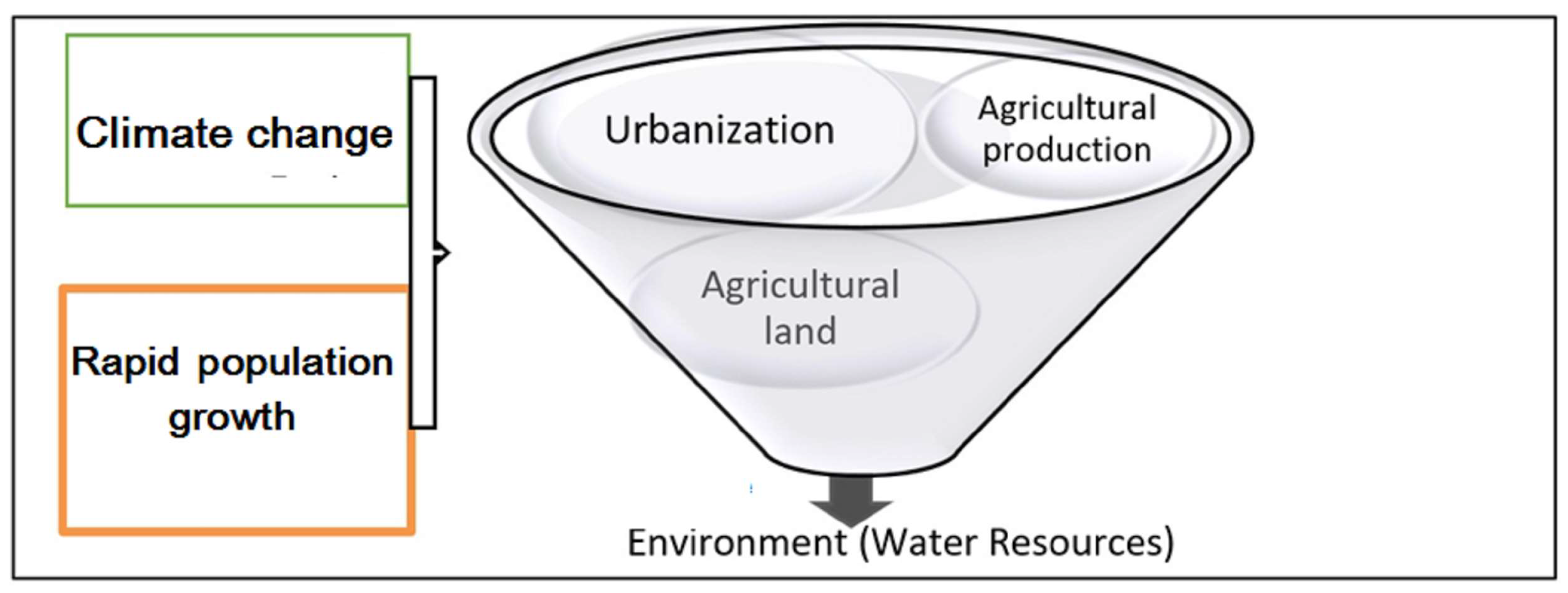
Consequently, this exerts mounting pressure on real estate resources, which are earmarked for urban development at the expense of agricultural lands. This creates a complex equilibrium equation within the geographical realm, entailing a trinity of urbanization, arable land, and groundwater, each of which demands careful consideration and management to ensure a harmonious coexistence.
The Algerian natural space, particularly the agricultural one, has become a subject of multiple pressures resulting from human activities, including agricultural production and urbanization. These activities have been a subject of controversy among local farmers, investors, and urban operators. As a consequence, agricultural spaces have gradually undergone a process of “artificialization” due to rapid urbanization.
The urbanization rate has experienced a remarkable increase, representing less than a third of the total population with 31.4% in 1966 and rising to two-thirds (65.94%) in 2008, with projections of reaching 85% by 2050, as per the Population and Housing Census of 2008 [
12]. Conversely, the Agricultural Land per Capita (ALC) has shown a concerning decline from 0.63 hectares in 1967 to 0.27 hectares in 2000, and further decreased to 0.19 hectares in 2018, according to [
13]. Moreover, agricultural lands serve as land reserves for the ever-expanding urbanization, a trend that presents a growing concern [
14]. The sustainability of peri-urban agriculture in semi-arid zones is in question, as it must address these multifaceted challenges while mitigating its adverse impacts on the environment [
15].
Between 1998 and 2018, the total area of urbanized zones in the province of Sétif increased by over 38%, from 2290 hectares to 3172 hectares, with an average annual growth of 1.5%. The urbanization rate of the province was 29.3% in 1987 and reached 47.9% in 2018. In the urban area of Sétif, agricultural land has decreased by 5.8% between 1987 and 2018 [
16], which have caused detrimental effects on the region’s food needs and local environmental sustainability.
The pressure on the surrounding agricultural lands of the city of Sétif is partly due to the city’s own expansion, demographic growth, and increased food demand, where the demographic basin reached 1.9 million inhabitants in 2019, according to local statistics [
17].
In addition to these factors, climate change and the perceived temperature rise have further exacerbated the ecosystem of the Sétif urban area, leading to large-scale wildfires in recent years, particularly in 2021 and 2022. This phenomenon raises questions about the need to revise agricultural practices and adopt new methods in the study area, despite the historical predominance of traditional agro-pastoral practices.
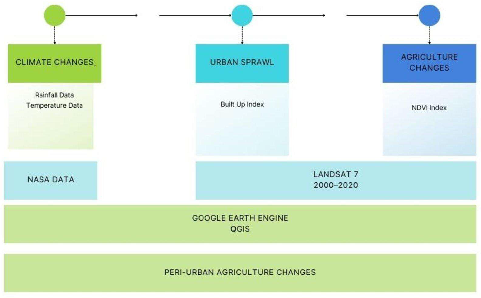
In summary, reconciling urbanization, population growth, and agriculture in the urban area of Sétif is a critical challenge to ensure sustainable regional development. The importance of this issue arises from the nature of the three structural elements, characterized by dualities and perpetual conflicts. The complex and vulnerable relationship between these elements emphasizes the significance of studying and monitoring the spatio-temporal evolution of these components within the local space, where environmental uncertainties are substantial, as depicted in
Figure 1.
The impact of urban dynamics on agricultural spaces, the overexploitation of groundwater, the conflicts arising from these phenomena, and the potential these vital elements could represent for the city all currently seem to be neglected aspects in urban policies [
18]. However, agriculture in peri-urban areas can hold strategic importance for the stability and environmental quality of the urban environment [
19].
Figure 1.
Perpetual duality between structural elements and the environment.
Figure 1.
Perpetual duality between structural elements and the environment.
The main objectives of this research are, firstly, to analyze the introduction, and then to analyze the temporal and spatial dynamics of irrigated crops in the study area. This diachronic and geographical approach will contribute to the understanding of agricultural transitions. Additionally, this study aims to explain the reasons behind the emergence of these crops in a semi-arid zone that was historically characterized by cereal farming, resulting in low to moderate annual yields due to erratic rainfall.
The crucial aspect of this research also involves measuring the impacts of irrigated crops on the local water table. By evaluating the underground water level drawdown, we aim to determine the environmental implications of irrigation on water resource availability, as well as the long-term sustainability of these practices.
This notably involves assessing the potential impact on crop diversification and resilience to climate change. By closely examining these aspects, we aim to provide insights to guide future agricultural practices in similar semi-arid areas.
Finally, the overarching objective of this study is to reach a consensus on the future use of peri-urban space, considering the evolution of agricultural and urban practices. This process aims to strive for the sustainable utilization of space by taking into account the food needs, environmental requirements, and urban development imperatives in the study area.
2. Study Area
In order to investigate the impact of climate change and urban expansion on péri-urban agriculture in semi-arid regions, the city of Sétif and its southern outskirts were selected as the study area based on two primary factors. The first factor is its geo-climatic characteristics. The study area (see
Figure 2) is situated in the eastern highlands of Algeria and is distinguished by a semi-arid climate. The second factor is the rapid urban expansion of Sétif, due to historical and economic considerations, which has directly influenced the regional dynamics of its territory. The study area extends over an area of approximately 1129.69 km
2 and had a population of 671,132 inhabitants (see
Table 1) in the year of 2020 [
12,
17,
20].
Naturally confined between Mount Mokrass at 1737 m to the north and the Harraanah Mountains to the south, represented by Mount Boutalib, which soars to an elevation of 1886 m (the summit of Afrajane), the study area stretches across a wide plain with an average elevation of 950 m above sea level. This region is characterized by dispersed and detached mountain masses, appearing sporadically, such as Mount Youssef at 1442 m. Moreover, the area is punctuated by marshes and saline depressions, including the Mullah Marsh, Al-Hamiyat Salt Flat, and the Meloul Salt Flat.
The study area, the peri-urban zone of Sétif (
Figure 2), was selected to investigate the issue of the emergence of irrigated cultures in a semi-arid zone facing climate change and urban expansion, and their impacts on peri-urban agriculture. It exhibits various natural, human, urban, and historical characteristics and factors. Situated in the eastern high plateau region of Algeria, it extends across a vast plateau at an average altitude of 950 m above sea level. The study area is characterized by its expansiveness and flatness, fostering demographic attractiveness and urban expansion.
The soil in the area is diverse, offering opportunities for agricultural activity. It consists mainly of continental deposits dating back to the Pliocene and Pleistocene periods, characterized by their lack of cohesion due to the presence of sandy silt and clay. The extensive limestone areas also provide significant opportunities for groundwater presence due to their higher permeability. Furthermore, the soils of recent deposits, especially along valleys, are of good quality and gray in color, while the remaining high plateau lands are characterized by limestone soils.
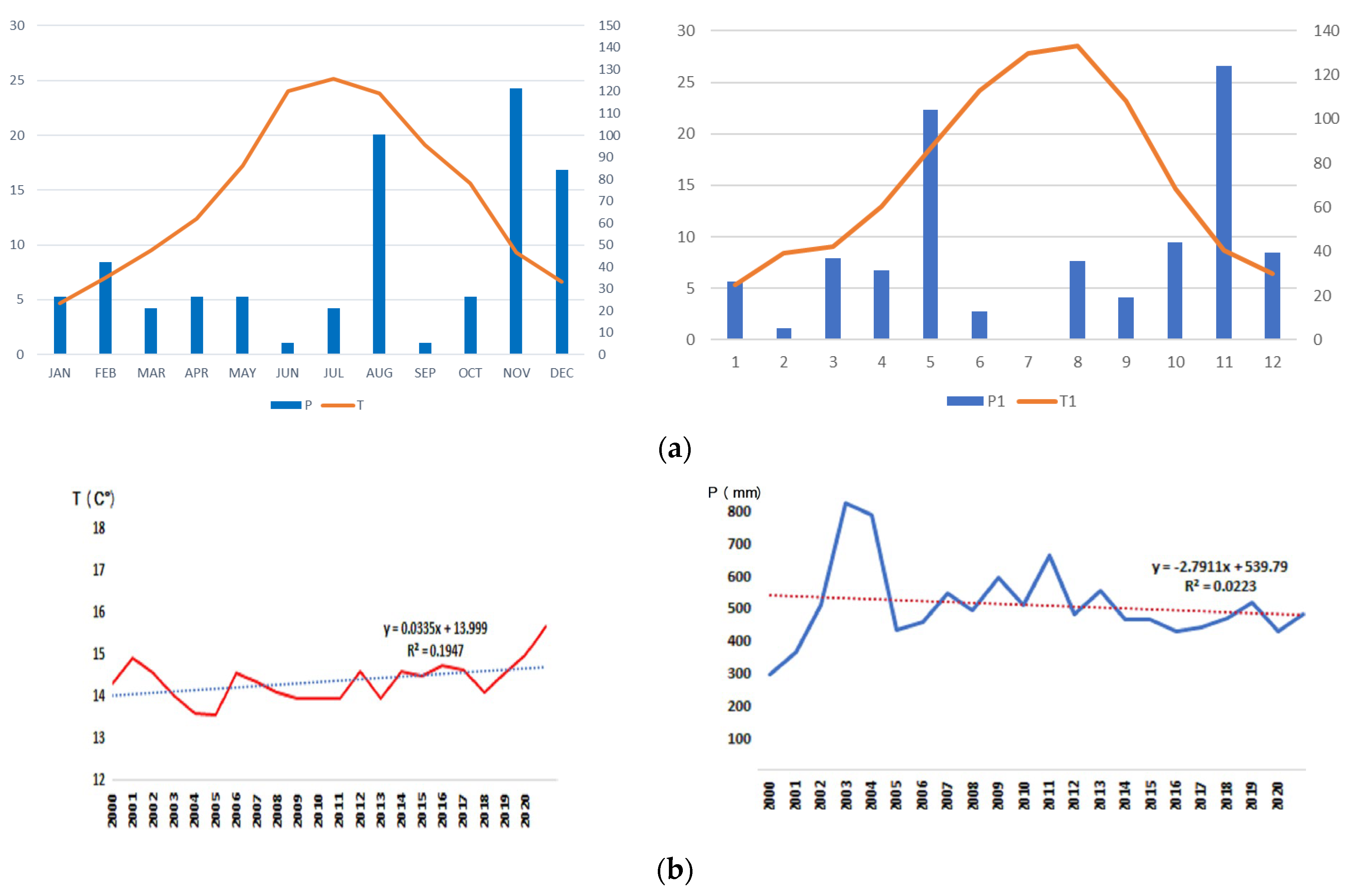
The study area features a semi-arid continental climate resulting from its central location between the Tellian and Saharan mountain ranges, characterized by hot and dry summers and cold winters. The precipitation regime is semi-arid, ranging from 200 mm to 400 mm per year with fluctuations, impacting agricultural yields, especially for cereal crops, and affecting human behavior, leading to recurrent shortages of certain food products.
The human factor is also crucial, as the Sétif province represents the second most important demographic center in the country after Algiers, with a population reaching 1.9 million inhabitants in 2020 [
17], generating high demands for food products and a fast urbanization process, which are both experiencing rapid growth; between 1998 and 2018, the total area of urbanized zones in the Sétif province increased by over 38%, reaching 47.9% in 2018 (Spatial Planning Plan of the Sétif province—Department of Agriculture, Internal Report, 2020).
Historically, the local population practiced cereal cultivation and sheep farming, which are activities that have been adapted to the climatic conditions of the study area, while irrigated plots were very limited. The introduction of irrigated cultures is a recent development. Following this presentation, it becomes apparent that various natural and geographical factors (excluding soil nature) do not favor the irrigated agriculture model. However, in recent years, there has been some expansion of this type of agriculture. All of these factors have contributed to directing our choice towards this area to study the new trend in agricultural exploitation models and their effects on the environmental balance of the area.
4. Results and Discussion
4.1. Climate Changes in the Study Area Are Trending towards Acidification
The data utilized in this study (
Figure 5a,b) confirm the semi-arid nature of the study area, which is consistent with previous research indicating that the Sétif region consistently maintains its status in the semi-arid bioclimatic zone, with a slight shift towards arid conditions [
23]. Moreover, the semi-arid climatic zone has experienced an increased susceptibility to drought in recent years due to reduced precipitation and prolonged dry periods, exacerbated by the delayed arrival of the autumn season, a factor that is currently impacting and will further affect the nature of agricultural crops [
24]. The crop cycle will accelerate, leading to consequences for early growth stages and cycle duration [
25], which will ultimately influence the agricultural production in the study area, which has been known for cereal cultivation and livestock farming, characterized by a concurrent and integrated cycle.
4.2. Urban Changes in the Study Area in Response to Population Pressure
Similar to other major cities in Algeria, the population increase and other urbanization factors [
23], which have been witnessed in the study area in general, specifically in the city of Setif, underscore the rapid urban expansion. This urban sprawl is characterized by two fundamental properties, dispersion and increasing land consumption [
26], particularly on agricultural lands to the east and south of the city.
The study area has experienced a significant population increase, as indicated in
Table 3. Additionally, the urbanized area in Setif has multiplied by tenfold, increasing from 338 hectares in 1966 to 3377 hectares in 2008 [
27].
According to [
28], urban expansions can take two forms. They can either be connected to existing urban structures, in which case they involve collective or individual residential structures. The areas near existing urban structures are suitable for development, and as a result, land parcels are easily sold at high values. The second type of expansion occurs in dispersed areas within agricultural regions and near roads. In this case, various commercial and craft activities (such as workshops, car wash stations, and small units for manufacturing construction materials) typically start, often initiated by investors or even farmers themselves.
4.3. Peri-Urban Agriculture
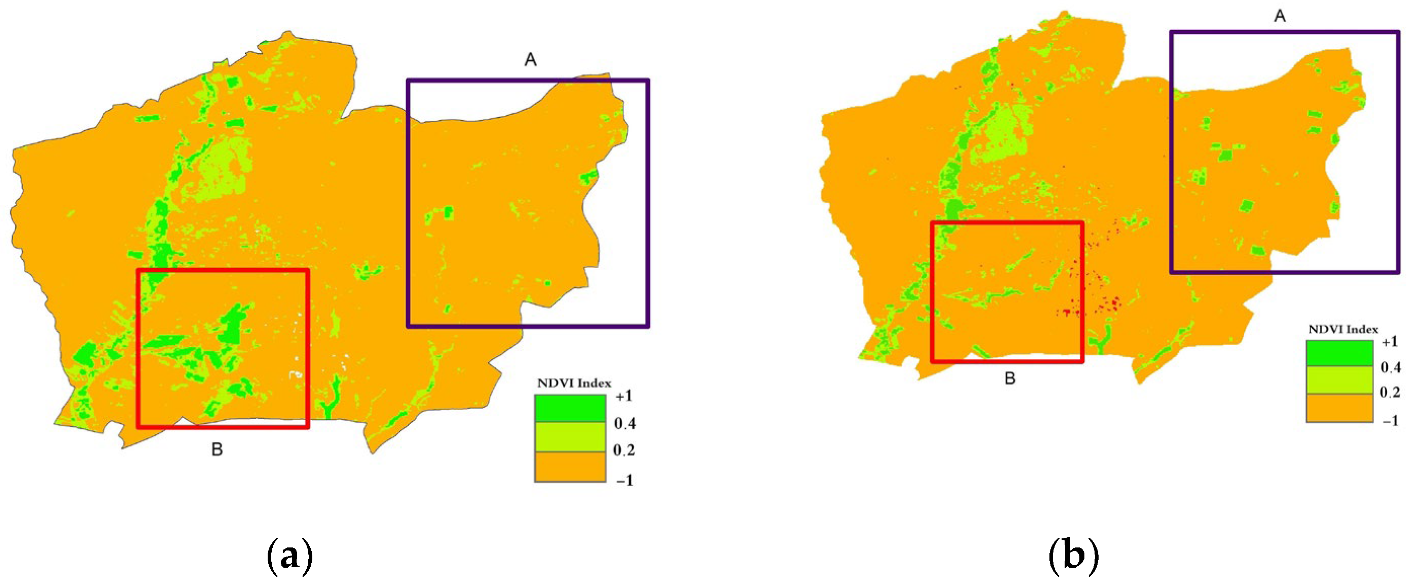
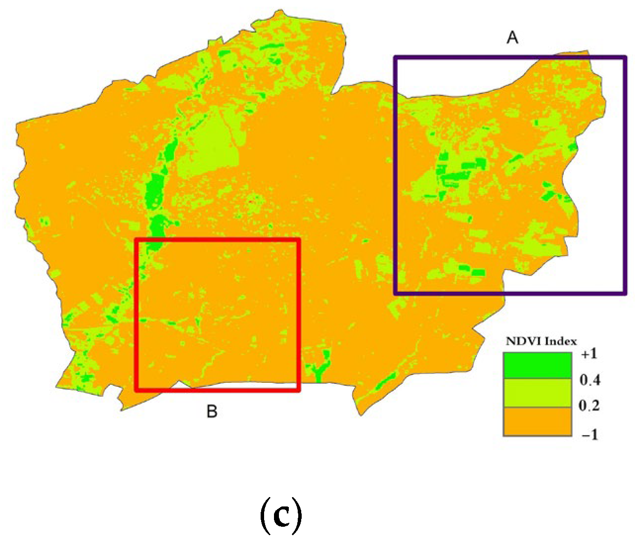
In this study, we relied on pixels with values ranging from 0.4 to 0.8 to accurately determine the vegetative cover, especially densely cultivated areas that are irrigated in the summer. This is due to the region’s semi-arid nature, where green areas are generally absent during the summer, except for forested areas or irrigated crops. Harvesting is typically complete, as the primary agricultural activity in the region has traditionally been cereal cultivation, as previously mentioned.
The use of the NDVI (Normalized Difference Vegetation Index) changes allowed us to understand the transformations in agricultural vegetative cover between the years of 2000 and 2020 within the study area. Substantial changes in land use patterns became evident, particularly in the north-eastern (A) and south-western (B) regions of Setif city (see
Figure 6). In these areas, the shift in land use has transitioned from cereal cultivation to more intensive open-field agriculture and the construction of plastic greenhouses, particularly in the southern part of the study region.
As previously noted, the region has historically been renowned for cereal cultivation. However, two key factors have contributed to this shift. First, the region has experienced climate changes, resulting in decreased precipitation, which was the primary source of support for cereal cultivation. Second, the expansion of urban areas due to population growth has significantly increased the demand for food, particularly the products of intensive agriculture, such as tomatoes, peppers, beetroots, salad, and carrots.
A noteworthy observation that is equally important is the proliferation of poultry farming in the southern part of the study region. Extensive areas and livestock stables for poultry and cattle have been observed on lands previously allocated for cereal crops. This reflects farmers’ attempts to compensate for the decline in income from cereal cultivation.
Furthermore, the peri-urban agriculture activities practiced in the study area provide seasonal employment opportunities. This is due to the unique nature of this form of agriculture, which requires the involvement of a significant workforce during the sowing, harvesting, and collection phases. The scarcity of jobs in the industrial and service sectors, especially in less-developed countries, motivates the population to engage in agricultural activities [
29].
4.4. Remarkable Evolution of Demographic and Agricultural Indicators in the Study Area during the Study Period (2000–2020)
The analysis of the data in
Table 3 shows a significant evolution of the three indicators, population, area of irrigated land, and horticultural production, in the study area between 2000 and 2020.
Table 3.
Evolution of population, irrigated lands, and horticultural production in the study area between 2000 and 2020.
Table 3.
Evolution of population, irrigated lands, and horticultural production in the study area between 2000 and 2020.
| Variables/Time | 2000 | 2010 | 2020 | 2000–2010 (%) | 2010–2020 (%) | 2000–2020 (%) |
|---|
| Population * | 447,529 | 525,424 | 671,132 | 17.40 | 27.73 | 49.96 |
| Area of irrigated land (hectare) ** | 5951 | 8581 | 8653 | 44.19 | 0.83 | 44.19 |
| Horticultural production (quintal) ** | 239,179 | 500,205 | 747,391 | 109.13 | 49.41 | 212.48 |
The population of the study area notably increased between 2000 and 2020 (
Table 3), rising from 447,529 inhabitants in 2000 to 671,132 inhabitants in 2020, marking a growth of 49.96% over two decades. The population growth rate was 17.44% during the first decade (2000–2010) and then 27.73% during the subsequent decade (2010–2020), indicating significant implications for land use, water resources, and agricultural product demand.
Furthermore, the area of irrigated land also substantially increased between 2000 and 2020, expanding from 5951hectares in 2000 to 8653hectares in 2020, marking a growth of 44.19% during the same period. This expansion of irrigated land not only demonstrates increased investment in water resources (through drilling) but also contributes to the depletion of the groundwater as a consequence.
However, during the period from 2010 to 2020, the irrigated area experienced stability primarily due to a decrease in precipitation volumes during the same period, which could not ensure sufficient groundwater replenishment.
Moreover, the production of vegetable crops surged significantly, rising from 239,179 quintals in 2000 to 747,391 quintals in 2020, with an annual increase of 10.2% and a staggering 212.4% increase between 2000 and 2020. This substantial agricultural growth is linked to the expansion of irrigated land (44.19%) during the same period, as well as a high local demand. However, climatic data, specifically the annual precipitation levels, revealed a regression starting from the year 2013, as depicted in
Figure 5b.
It is important to highlight that a significant number of farmers exploiting these lands are not the actual owners of the agricultural land. They come from neighboring regions and choose to lease these lands. Their primary motivations are immediate profit and short-term financial returns. In this context, they often fail to consider the implications of the excessive exploitation of groundwater in the long term. This dynamic highlights a form of natural resource exploitation that lacks rationality in the study area.
4.5. Substantial Growth in Protected Crop Cultivation (Plastic Greenhouses)
The current trends in plastic greenhouses and its production exhibit impressive growth (see
Table 4). Between 2000 and 2020, this kind of agriculture expanded by 20 times, increasing from 19.88 to 405.89 hectares. Similarly, production witnessed a remarkable increase by 48 times, rising from 9310 to 455,455 quintals. These indexes indicate a consistent upward trend. Moreover, during the period of 2000–2010, the covered area surged by 295.47%, escalating from 19.88 to 78.62 hectares. The production of protected crops also saw a significant increase of 362.30%, rising from 9310 to 43,041 quintals.
Even better, during the period from 2010 to 2020 (
Table 4), we observed a more significant growth. The covered area increased by 416.26%, rising from 78.62 to 405.89 hectares. Additionally, production surged by 958,188%, escalating from 43,041 to 455,455 quintals. Overall, there was a more substantial growth observed both in terms of covered area and horticultural crop production during the 2010–2020 period compared to the 2000–2010 period.
Table 4.
The evolution of protected crops in the study area during the study period (2000–2020).
Table 4.
The evolution of protected crops in the study area during the study period (2000–2020).
| Variables/Time | 2000 | 2010 | 2020 | 2000–2010% | 2010–2020% | 2000–2020% |
|---|
| Protected Area (H) | 19.88 | 78.62 | 405.89 | 295.47 | 416.26 | 1941.70 |
| Production (QX) | 9310 | 43,041 | 455,455 | 362.30 | 958.188 | 4792.10 |
This agricultural dynamic heavily relies on groundwater, which remains a public asset under state ownership according to Law 83–17 (Water Code of 1983). However, the use of boreholes, whether authorized or not, operates under strictly private logic and sometimes eludes state control. The current functioning of the groundwater governance system indeed encourages borehole owners to maximize water withdrawals from these sources [
30]. Moreover, semi-arid regions face water stress and challenges concerning economic development, making the establishment of sustainable agricultural projects less reassuring.
In conclusion, this observation underscores the crucial importance of the sustainable and effective management of natural resources to meet the growing population’s demands. It is essential to remain vigilant in the face of these trends and adjust development policies to ensure a balance between the increasing needs of the population and the groundwater resources of the study area, as extraction rates exceed the recharge of the aquifer.
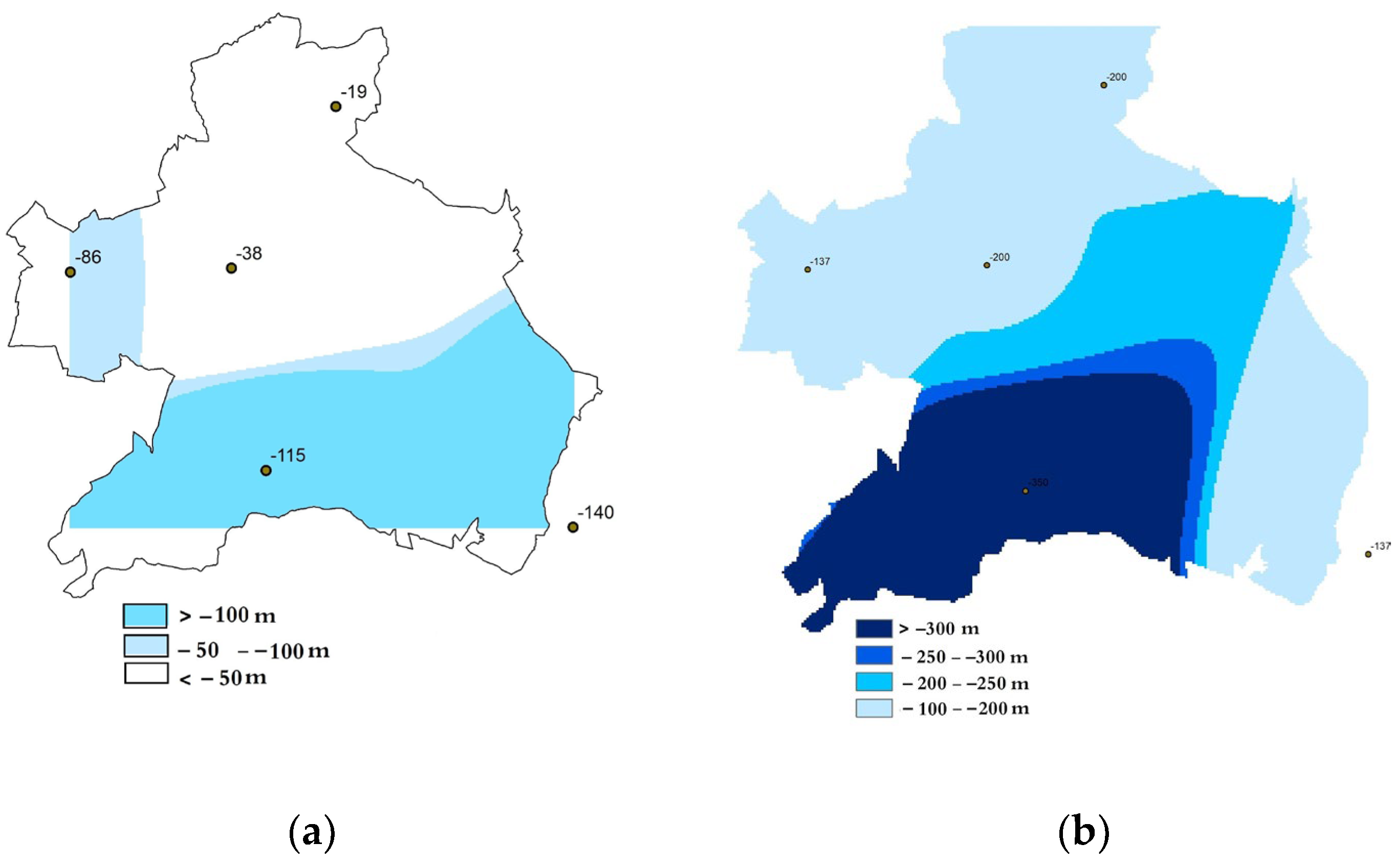
4.6. Excessive Exploitation of Underground Water Levels
The levels of regular and artesian wells have been affected due to the decline in underground water levels, primarily supplied by seasonal precipitation. The underground water levels have dropped from less than 50 m in the northern areas before 2015 to over 150 m by the end of 2022 (see
Figure 7). In contrast, in the southern region, the depth of groundwater levels surpassed 300 m in 2022, as observed in the Ain Oulmene area, while previously, it did not exceed 100 m in extreme cases [
31].
This can be explained by two main indicators. The first indicator is climate change, resulting from decreased precipitation and an increased demand for groundwater resources, particularly in intensive summer agriculture.
The second factor is the demand arising from urban expansion and associated human activities. With the continued phenomenon of drought and reduced precipitation, almost all wells have dried up completely or nearly so (four out of five wells). This has prompted investors to seek permission from the Administrative and Technical Authority for Groundwater Resources to drill deeper wells, reaching depths of up to −350 m in certain areas, such as Ain Oulman. This situation reflects a state of groundwater depletion in the study area and creates difficulties in restoring balance to groundwater levels, especially given the non-harmonious hydrogeological structure of the region.
5. Conclusions
The relationship between urban populations and the natural environment remains a vital and fragile issue, as ensuring a comprehensive balance among the environmental elements in which they reside, especially between urban expansion and neighboring farmlands, proves to be challenging. This duality has long been based on a struggle for control over one another.
The studied area (the peri-urban zone of Setif) has known significant transformations in the past twenty years (2000–2020), with the most prominent being the significant rate of population growth. Their number shifted from 447,529 in 2000 to 671,132 in 2020, representing an increase of approximately 49%. Consequently, the city of Setif, along with its peri-urban area, transformed into a regional metropolis. This human weight produced a shift in agricultural patterns by introducing intensive agriculture. The irrigated agricultural areas increased by 44.19% between 2000 and 2020, leading to a 212.4% rise in vegetable production during the same period. Additionally, a qualitative evolution occurred with the emergence of protected agriculture using plastic greenhouses, expanding from 19.88 hectares in 2000 to 405.89 hectares in 2020 (an increase of 20 times in area). All of these transformations took place in a region that was previously characterized by grain cultivation and ranching. In contrast to these significant changes, the underground water level has shifted from a depth of −50 m to −150 m in the northern study area. In the south, the water depth has reached −300 m.
This new pattern—irrigated and protected agriculture—is unintended and undefined in the state’s major goals and directions. This the result of automatic, individual, and collective choices made by official and unofficial actors aiming to earn quick profits. This pattern remains unknown in its consequences, in a changing climate characterized by periods of drought, fluctuating and decreasing precipitation, alongside a decline in underground water levels in the study area. Consequently, the water in the study area will not comply with the new direction of agriculture, which leans towards depleting local groundwater. This faces a challenge due to insufficient precipitation. Thus, it requires diverting water from the more rainfall-abundant northern coastal regions to the semi-arid inland areas as a first step. However, in our opinion, it is necessary to explore the process of desalinating seawater (100 km away) to meet the water demands of both the population and agriculture simultaneously.
Finally, in order to ensure a new equilibrium between population, urban growth, and agriculture in peri-urban areas, especially in semi-arid regions, it is necessary to incorporate the issue of food into the planning programs and local and regional development tools in the future. This is especially crucial as the state continues to respond to social housing needs in an urgent manner at the expense of agricultural land. Additionally, there is a haphazard exploitation of underground water, leading to situations that open up another area of research into how to manage underground water in the region and protect the environment in semi-arid areas amidst climate change. Also, it is possible to direct future attention towards the comprehensive study and analysis of the relationship between these variables in a deeper and partial manner, aiming ultimately to develop interpretations that assist in making more realistic decisions.


