

Corridors Construction and Development Strategies for Intangible Cultural Heritage: A Study about the Yangtze River Economic Belt


Abstract
:1. Introduction
2. Methods and Data
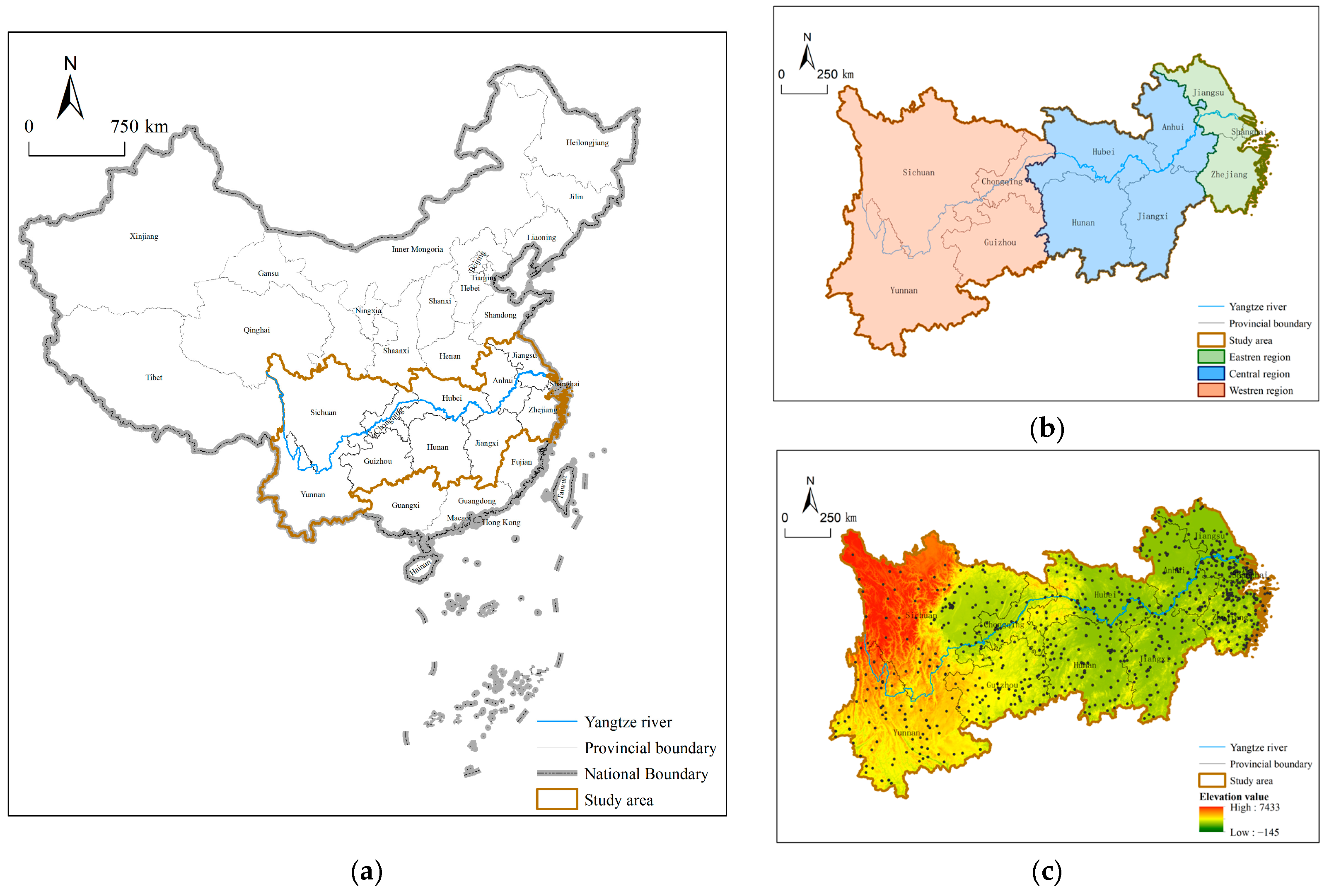
2.1. Study Area
2.2. Data Sources
2.3. Research Methods
2.3.1. Kernel Density Analysis
2.3.2. Standard Deviational Ellipse Analysis
2.3.3. Geological Hazard Susceptibility Evaluation
2.3.4. AHP
2.3.5. Suitability Analysis
2.3.6. Point Density Analysis
3. Results and Analysis
3.1. Spatial Distribution Characteristics of ICH
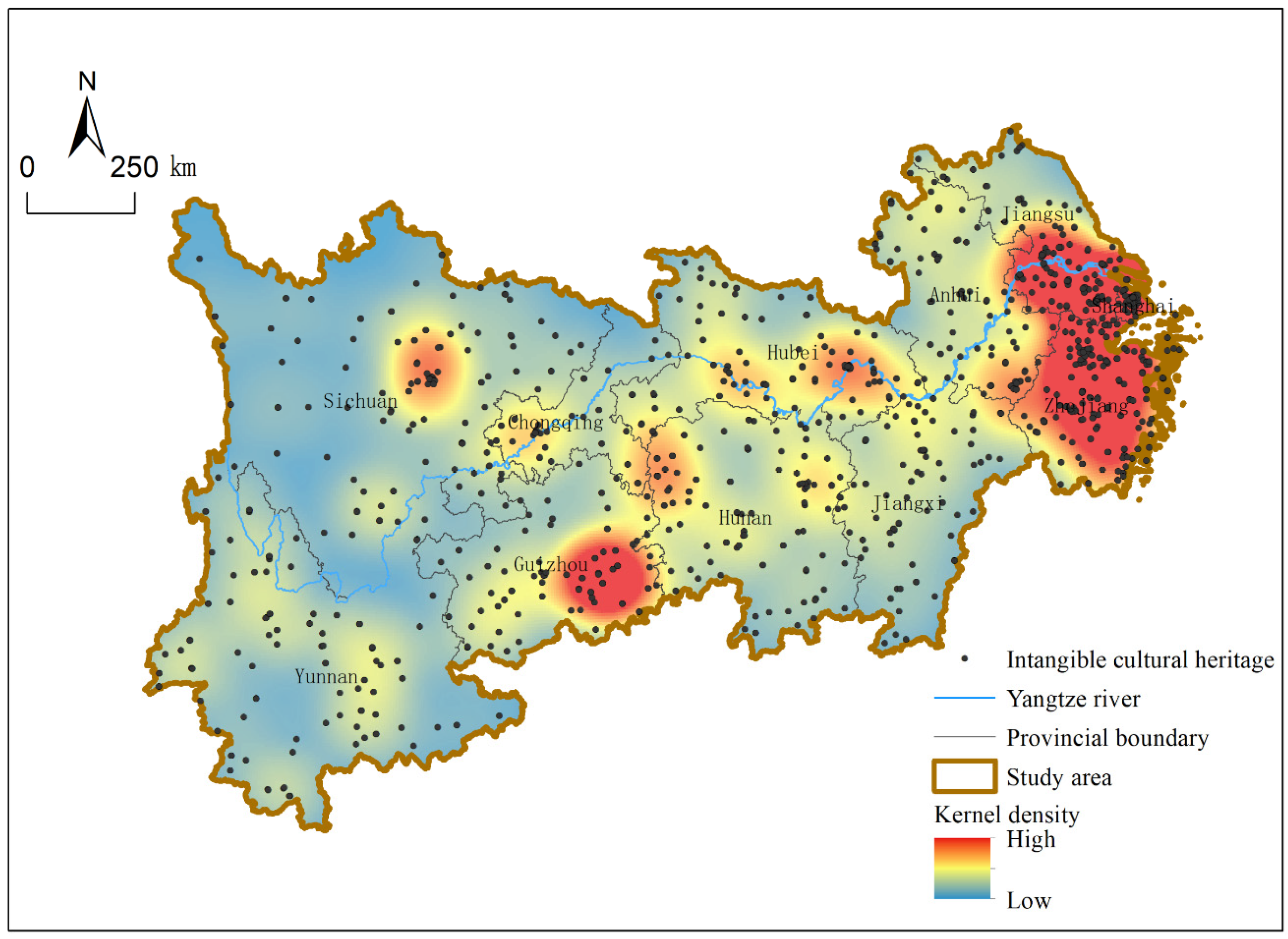
3.1.1. Overall Pattern of ICH Distribution
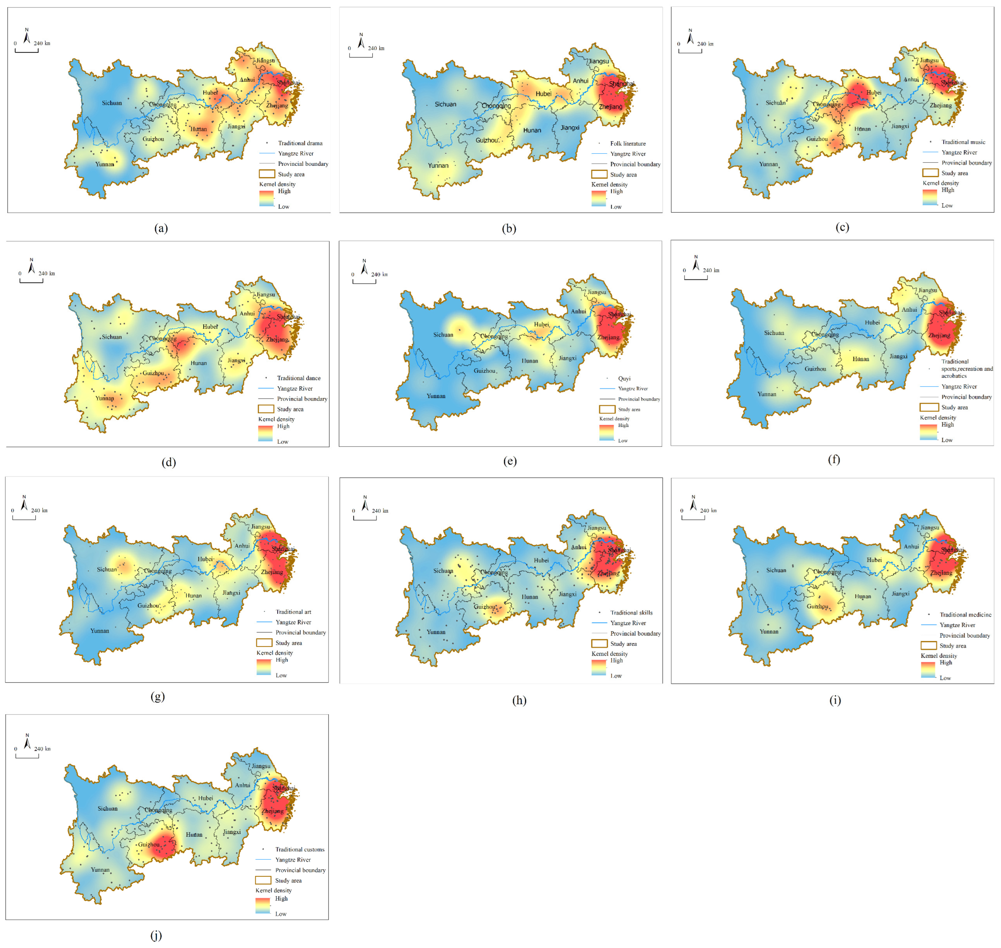
3.1.2. Regional Distribution Differences of ICH Types
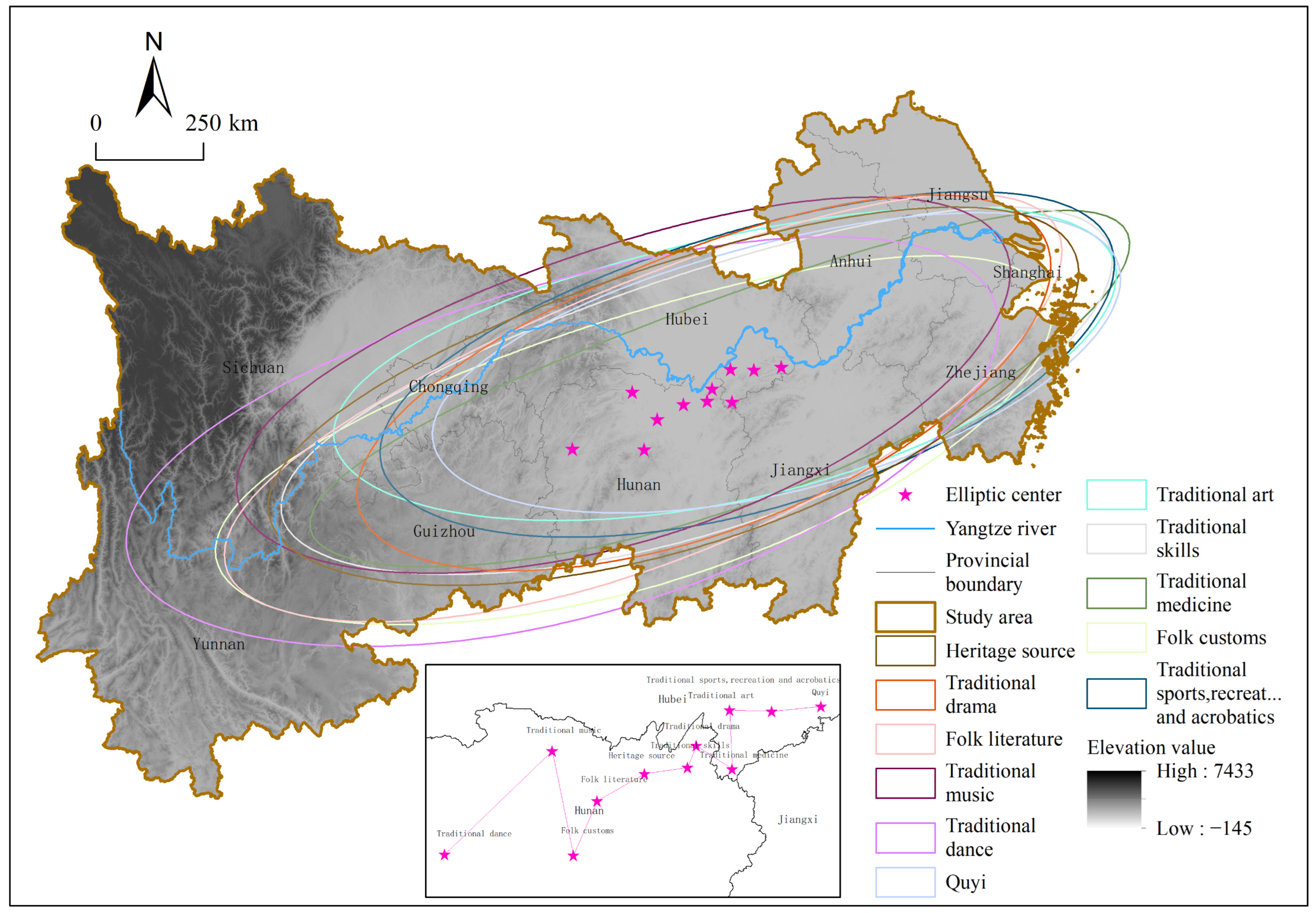
3.1.3. Direction Distribution Characteristics of ICH
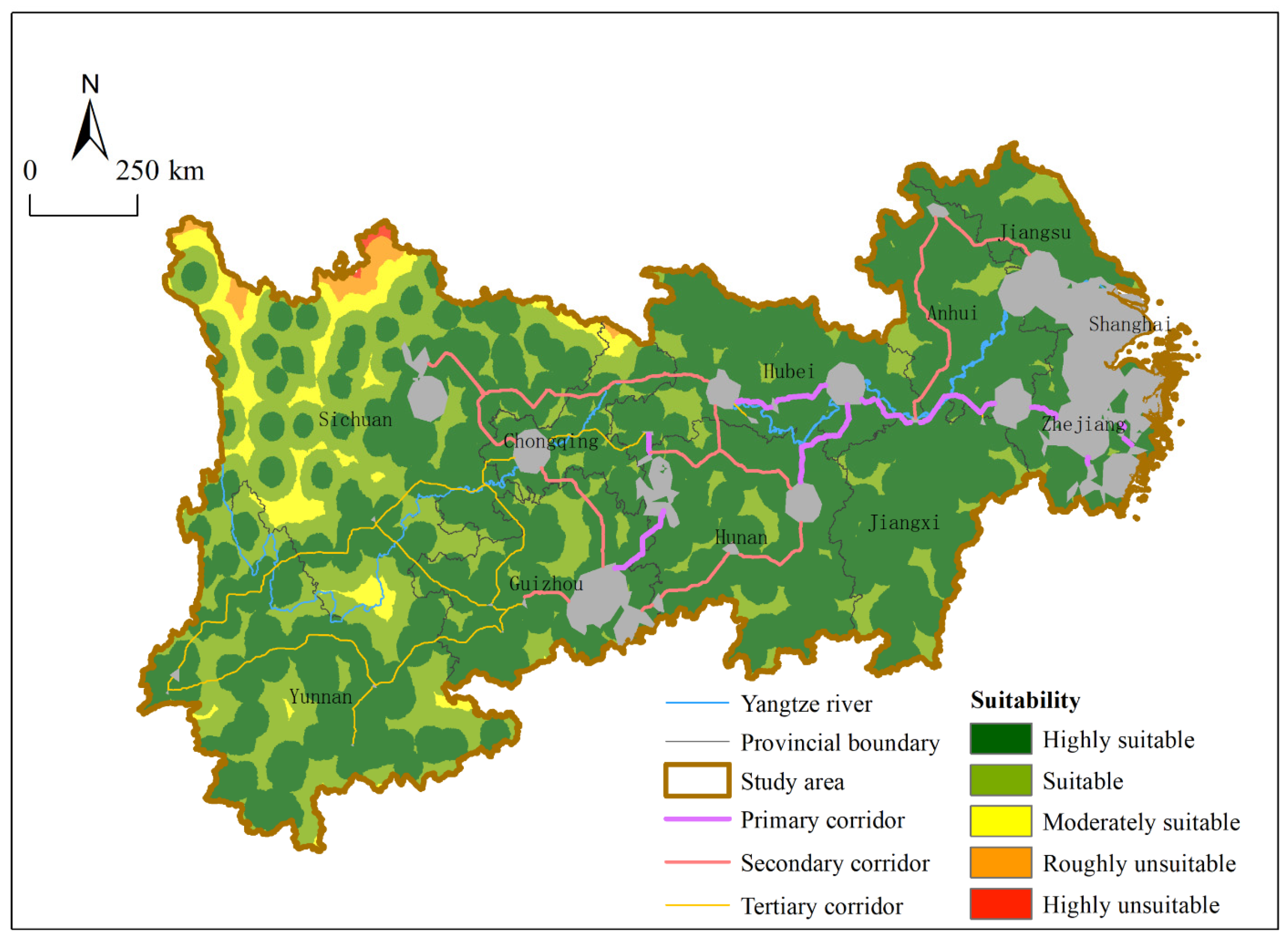
3.2. Identification of Heritage Corridor
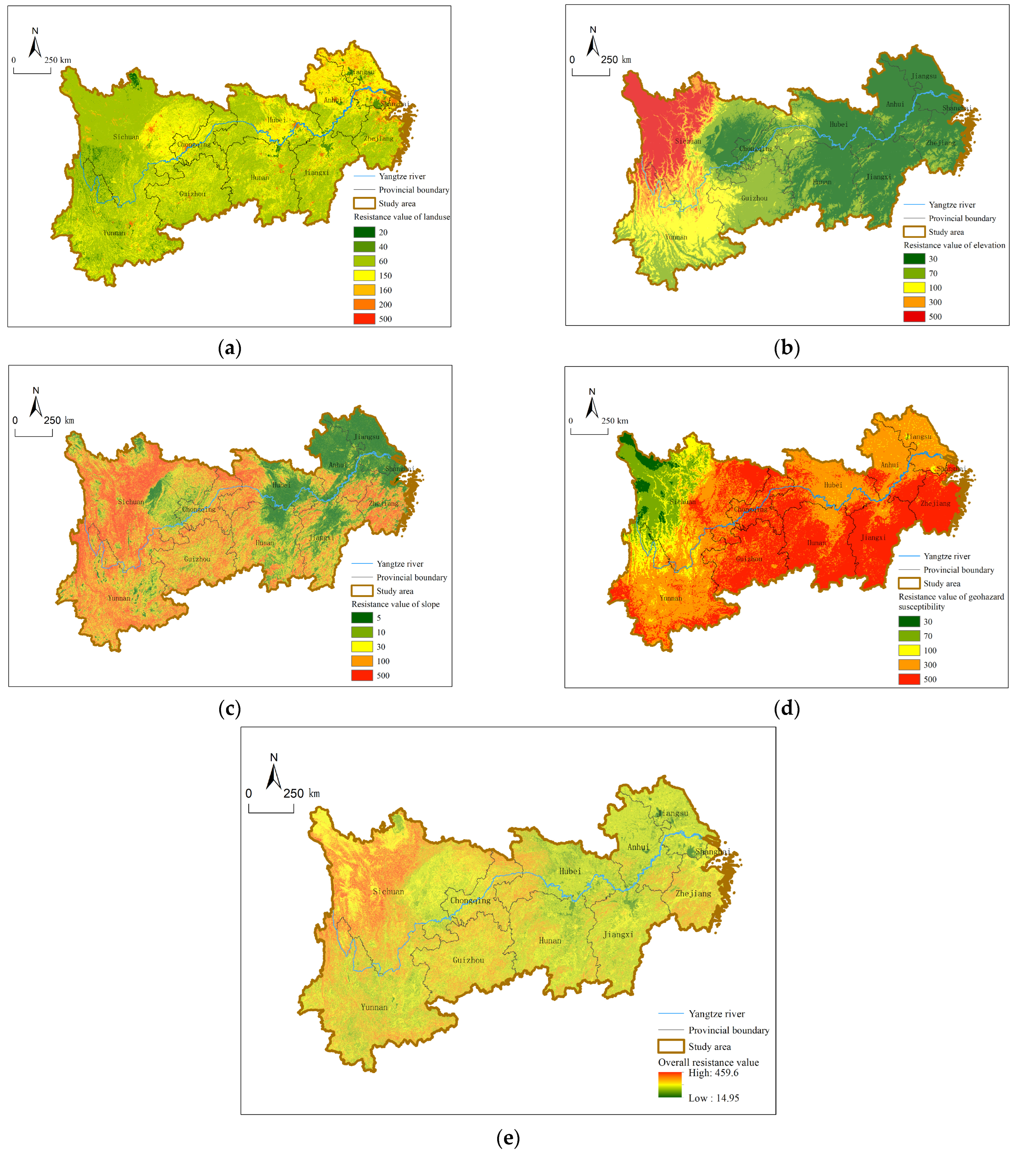
3.2.1. Construction of Overall Resistance Surface
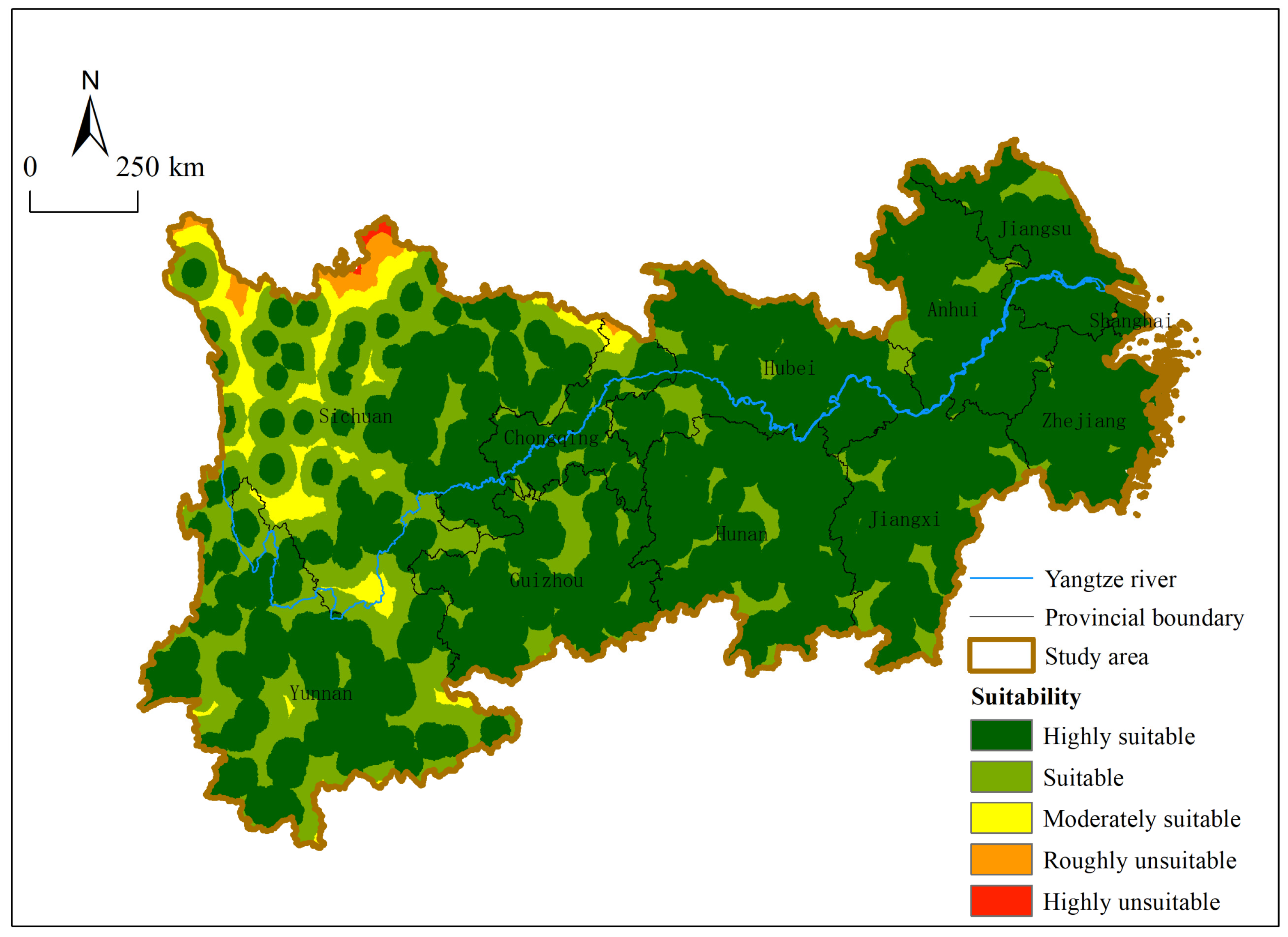
3.2.2. Suitability Analysis of Heritage Corridor Construction
4. Discussion
4.1. Generation of Spatial Features of ICH
4.2. Construction Strategy of Heritage Corridor Considering Regional Factors
4.2.1. Heritage Corridor Construction
4.2.2. Development Strategy of Heritage Corridors Based on Regional Differences
4.2.3. Expansion Strategy of Heritage Corridors Based on Influence Domain
4.3. Contributions and Limitations
5. Conclusions
- (1)
- The density and distribution of ICH in the Yangtze River Economic Belt have distinct regional characteristics: most of the high-density areas are in the eastern region, yet the low-density areas are concentrated in the western region. The quantity and type of ICH vary among provinces. There is little difference in the quantity of ICH in the east, central and west regions, but obvious difference in the type.
- (2)
- The suitability analysis based on the MCR model shows that the suitability of heritage corridor construction in the Yangtze River Economic Belt decreases from east to west. The unsuitable areas are mainly located in western Sichuan, northern Chongqing, and the junction of Liangshan Prefecture of Sichuan and Yunnan Provinces. The suitable areas are distributed in central and western regions such as Zhejiang, Shanghai, Jiangsu, Anhui, Jiangxi, Hunan and Hubei.
- (3)
- Through the ArcGIS point density analysis tool, the high-density distribution areas of ICH in the Yangtze River Economic Belt are extracted as the key source area for constructing heritage corridors. Finally, a total of 37 main corridors are obtained through screening and identification with the cost path tool. Then these corridors are divided into 16 primary corridors, 12 secondary corridors and 9 tertiary corridors according to the suitability of corridor construction and the size of source areas. Among them, the primary corridors are mostly distributed in the eastern and central regions, the secondary corridors are mainly in the central and western regions, and the tertiary corridors are in the western region. In addition to corridor identification by spatial analysis, linear landscape and integration of single heritage are also important corridor construction methods.
- (4)
- Regional differences should be taken into account in the development of heritage corridors. The Yangtze River Economic Belt runs from east to west, and the characteristics of ICH types in the eastern, central and western regions are distinct. The three regions differ significantly in the suitability of heritage corridor construction. Therefore, different corridor development strategies should be adopted according to the situation of ICH and the regional socio-economic conditions. Due to the limited width of the heritage corridor, it is also necessary to increase the corridor’s influence domain, so that more government departments and industries can participate in the protection of ICH.
Author Contributions
Funding
Institutional Review Board Statement
Informed Consent Statement
Data Availability Statement
Acknowledgments
Conflicts of Interest
References
- Tang, L.L. Interpretation of the Convention for the Safeguarding of the Intangible Cultural Heritage. China Intang. Cult. Herit. 2021, 2, 109–113. [Google Scholar]
- Soares, M.G.B.; Santos, L.D.S.; Sousa, L.A.D.; Benatti, J.H.; Alves, H.P.; Mustafa, E.V. Cultural environment: Legal Protection of Intangible Cultural Heritage in Amazonas and Popular Participation. Int. J. Adv. Eng. Res. Sci. 2019, 6, 635–639. [Google Scholar] [CrossRef]
- Lee, G. How to Protect Traditional Food and Foodways Effectively in Terms of Intangible Cultural Heritage and Intellectual Property Laws in the Republic of Korea. Int. J. Cult. Prop. 2018, 25, 543–572. [Google Scholar] [CrossRef]
- dBang-rgyal, b. Intangible Cultural Heritage: The Cultural Connotation and Protection of Xinlong Medicine Mud Mask. Front. Educ. Res. 2019, 2, 29–35. [Google Scholar]
- Ma, M. Research on the Protection of Intellectual Property Rights of Intangible Cultural Heritage. Acad. J. Humanit. Soc. Sci. 2023, 6, 58–64. [Google Scholar] [CrossRef]
- Yan, Y.F.; Zhi, G. Study on Legislation and Practice of Intellectual Property Protection of Intangible Cultural Heritage. Leg. Panor. 2022, 38, 22–24. [Google Scholar]
- Lin, Q.; Lian, Z. On Protection of Intangible Cultural Heritage in China from the Intellectual Property Rights Perspective. Sustainability 2018, 10, 4369. [Google Scholar] [CrossRef]
- Yao, G.Z.; Xue, Y. Challenges of Intangible Cultural Heritage Protection and Focus of Digital Protection. Panor. Chin. Natl. 2021, 30, 97–99. [Google Scholar]
- Yuan, Q.L. Research based on Digital Protection and Development of China’s Intangible Cultural Heritage. Cult. Ind. 2021, 14, 88–90. [Google Scholar]
- Yu, L. Digital Sustainability of Intangible Cultural Heritage: The Example of the “Wu Leno” Weaving Technique in Suzhou, China. Sustainability 2023, 15, 9803. [Google Scholar] [CrossRef]
- Kim, S.; Im, D.U.; Lee, J.; Choi, H. Utility of Digital Technologies for the Sustainability of Intangible Cultural Heritage (ICH) in Korea. Sustainability 2019, 11, 6117. [Google Scholar] [CrossRef]
- Chen, M.; Wang, J.; Sun, J.; Ye, F.; Zhang, H. Spatio-Temporal Distribution Characteristics of Intangible Cultural Heritage and Tourism Response in the Beijing–Hangzhou Grand Canal Basin in China. Sustainability 2023, 15, 10348. [Google Scholar] [CrossRef]
- Ramón-Cardona, J.; Sánchez-Fernández, M.D. Tangible and Intangible Heritage of Ibiza (Spain) and Its Potential to Be Valued as a Tourist Offer. Heritage 2022, 5, 70. [Google Scholar] [CrossRef]
- Maldonado-Erazo, C.P.; del Río-Rama, M.d.l.C.; Andino-Peñafiel, E.E.; Álvarez-García, J. Social Use through Tourism of the Intangible Cultural Heritage of the Amazonian Kichwa Nationality. Land 2023, 12, 554. [Google Scholar] [CrossRef]
- Floričić, T.; Jurica, K. Wine Hotels—Intangible Heritage, Storytelling and Co-Creation in Specific Tourism Offer. Heritage 2023, 6, 159. [Google Scholar] [CrossRef]
- Chen, C.X. Study on the Development of Intangible Cultural Heritage Tourism Resources in Henan Province. Trade Fair Econ. 2023, 5, 35–37. [Google Scholar]
- Askar, B.; Jing, L.J.; Zhang, J.N.; Lu, Y.N. Development Status and promotion path of Sports Intangible Cultural Heritage Tourism in Xinjiang. Sports Cult. Guide 2023, 24, 104–110. [Google Scholar]
- Agapiou, A.; Lysandrou, V.; Alexakis, D.D.; Themistocleous, K.; Cuca, B.; Argyriou, A.; Sarris, A.; Hadjimitsis, D.G. Cultural heritage management and monitoring using remote sensing data and GIS: The case study of Paphos area, Cyprus. Comput. Environ. Urban Syst. 2015, 54, 230–239. [Google Scholar] [CrossRef]
- Nicu, I.C. Cultural heritage assessment and vulnerability using Analytic Hierarchy Process and Geographic Information Systems (Valea Oii catchment, North-eastern Romania). An approach to historical maps. Int. J. Disaster Risk Reduct. 2016, 20, 103–111. [Google Scholar] [CrossRef]
- Du, L.; Zhang, R. Coexisting Protection of the Inheritance Environment of Intangible Cultural Heritage in the Process of Urbanization: A Case Study of Shehuo in Long County and the Protection of Its Inheritance Material Environment. Huazhong Archit. 2019, 37, 23–27. [Google Scholar]
- Liu, W.Y. Research on the Emergency Mechanism of Intangible Cultural Heritage Protection in Major Natural Disasters. Master’s Thesis, Xiangtan University, Xiangtan, China, 2014. [Google Scholar]
- Julian, S. Theory of Cultural Change; Guizhou People’s Publishing House: Guiyang, China, 2013. [Google Scholar]
- Xiang, Y.J. The Materiality of Intangible Cultural Heritage: Some Philosophical Issues on Intangible Cultural Heritage. J. Minzu Univ. China 2010, 37, 63–72. [Google Scholar]
- Liu, K.L. The Holistic Principle of Intangible Cultural Heritage and Its Protection. J. Guangxi Teach. Educ. Univ. 2004, 32, 1–8. [Google Scholar]
- Li, W.; Yu, K.J.; Li, D.H. Theoretical Framework of Overall Protection of Heritage Corridor and Grand Canal. Urban Probl. 2004, 23, 28–31. [Google Scholar]
- Holladay, P.; Skibins, J.C.; Zach, F.J.; Arze, M. Exploratory Social Network Analysis of Stakeholder Organizations Along the Illinois and Michigan Canal National Heritage Corridor. J. Park Recreat. Adm. 2017, 35, 37–48. [Google Scholar] [CrossRef]
- Goula, M.; Vanucchi, J. Sustained Change: Design Speculations on the Performance of Fallow-Scapes in Time along the Erie Canal National Heritage Corridor, (ECNHC), New York. Sustainability 2022, 14, 1675. [Google Scholar] [CrossRef]
- Byrne, D. The migration heritage corridor: Transnationalism, modernity and race. Int. J. Herit. Stud. 2023, 29, 329–334. [Google Scholar] [CrossRef]
- Cerquetti, M.; Ferrara, C.; Romagnoli, A.; Vagnarelli, G. Enhancing Intangible Cultural Heritage for Sustainable Tourism Development in Rural Areas: The Case of the “Marche Food and Wine Memories” Project (Italy). Sustainability 2022, 14, 16893. [Google Scholar] [CrossRef]
- Qiu, Q.H.; Zuo, Y.F.; Zhang, M. Intangible Cultural Heritage in Tourism: Research Review and Investigation of Future Agenda. Land 2022, 11, 139. [Google Scholar] [CrossRef]
- Wang, G.W.; Cheng, J.L.; Zhao, M.Y.; Wu, M.J. Evaluation on the Suitability of Heritage Tourism Development in Tea Cultural Heritage Corridor Node Cities: A Case Study of the Chinese Section of the Ten Thousand Li Tea Route. West Forum Econ. Manag. 2022, 33, 66–77. [Google Scholar]
- Sun, T.; Huang, T. Cognition, Protection and Inheritance of Grand Canal Heritage from A Multi-Dimensional Perspective. Soc. Sci. China 2023, 3. [Google Scholar]
- Feng, B.; Ma, Y. Network Construction for Overall Protection and Utilization of Cultural Heritage Space in Dunhuang City, China. Sustainability 2023, 15, 4579. [Google Scholar] [CrossRef]
- Li, X.Y.; Xia, H.S. A study on the value evaluation of railway heritage corridor: A case study of Beijing-Zhang Railway (Beijing Section). South Archit. 2023, 43, 40–51. [Google Scholar]
- Wang, Y.Z. Study on the Cultural Heritage Value Cognition of the Gansu Section of the Silk Road from the Perspective of Heritage Corridor. Soc. Sci. Rev. 2021, 36, 107–115. [Google Scholar]
- Li, Y.; Wang, C.Z.; Wang, P.; Wang, C.C. A Study on the Construction of Heritage Corridors: A Case Study of Fenghe in Daxing District, Beijing. J. Beijing Univ. Civ. Eng. Archit. 2023, 39, 27–35. [Google Scholar]
- Li, W.X.; Cao, X.M. Construction Method of Traditional Village Heritage Corridor along the Great Wall of Ming Dynasty in Shanxi Province based on Suitability analysis. Small Town Constr. 2022, 40, 59–68. [Google Scholar]
- Li, H.; Gao, S.; Zhao, J.; Gao, Y.F.; Zhao, Y. Study on Linear Intangible Cultural Heritage Corridor Construction in Guizhou Province Based on Minimum Cumulative Resistance Model. J. Guizhou Norm. Univ. 2022, 38, 42–50. [Google Scholar]
- Wu, Q.; Li, X.G.; Zhang, M. Spatial distribution and causes of different types of intangible cultural heritage in China. Econ. Geogr. 2015, 35, 175–183. [Google Scholar]
- Liao, L.Q.; Hu, J. Spatial-temporal characteristics and evolution of intangible cultural heritage types in Yangtze River Economic Belt. J. Cent. China Norm. Univ. 2019, 53, 804–814. [Google Scholar]
- Cheng, Q.; Ling, S.P. Analysis of the spatial distribution characteristics and influencing factors of intangible cultural heritage in China. Geogr. Sci. 2013, 33, 1166–1172. [Google Scholar]
- Xu, B.C.; Pan, J.H. Spatial Spatial distribution characteristics and influencing factors of national intangible cultural heritage in China. Econ. Geogr. 2018, 38, 188–196. [Google Scholar]
- Fang, K.; Wu, D.K.; Yang, Y. Study on the Overall Protection Mode of the Intangible Cultural Heritage of Ethnic minorities. Guizhou Ethn. Stud. 2019, 40, 47–51. [Google Scholar]
- Liu, M.; Zhang, A.; Zhang, X.; Xiong, Y. Research on the Game Mechanism of Cultivated Land Ecological Compensation Standards Determination: Based on the Empirical Analysis of the Yangtze River Economic Belt, China. Land 2022, 11, 1583. [Google Scholar] [CrossRef]
- Liu, W.H.; Jia, H.R.; Xie, A.P. study on the susceptibility zoning of geological disasters in Lanzhou City. Soil Water Conserv. China 2023, 44, 33–38. [Google Scholar]
- Deng, X.; Li, J.M.; Zeng, H.J.; Chen, J.Y.; Zhao, J.F. Analytic hierarchy process weight calculation method analysis and its application research. Math. Pract. Underst. 2012, 42, 93–100. [Google Scholar]
- Knaapen, J.P.; Scheffer, M.; Harms, B. Estimating habitat isolation in landscape planning. Landsc. Urban Plan 1992, 23, 1–16. [Google Scholar] [CrossRef]
- Zhan, Q.M.; Guo, H.G. Suitability analysis method for heritage corridors based on GIS and RS. Planners 2015, 31, 318–322. [Google Scholar]
- Su, Y.; Ma, Y.; Chen, M.Q.; Wang, S.S. Research on the construction of the Gubeikou Great Wall Heritage Corridor based on ecological suitability evaluation. Beijing Plan. Constr. 2022, 36, 125–129. [Google Scholar]
- Yang, X.K.; Chen, J.H. Study on the Construction of Linear Intangible Cultural Heritage Corridor in the Silk Road Economic Belt. Resour. Environ. Arid Zone 2021, 35, 202–208. [Google Scholar]
- Zhao, Y.J.; Li, Y.B.; Shao, J.A. Ecological Risk Assessment of Small Watershed based on Land Use Change: A Case Study of Caotangxi in Three Gorges Reservoir Area. J. Nat. Resour. 2013, 28, 944–956. [Google Scholar]
- Teng, Y.B. Research on the Construction of Heritage Corridor of Xiaohe Ancient Road based on Minimum Accumulative Resistance Model. Planners 2020, 36, 66–70. [Google Scholar]
- Yu, K.J.; Li, W.; Li, D.H.; Li, C.; Huang, G.; Liu, H. The Suitability Analysis Method of Heritage Corridor in Rapid Urbanization Area: A Case Study of Taizhou City. Geogr. Res. 2005, 24, 69–76. [Google Scholar]
- Hu, X. Research on the Construction, Protection and Development of Heritage Corridors in Mountainous Cities from the Perspective of Geological Ecological Environment. Master’s Thesis, Chongqing University, Chongqing, China, 2023. [Google Scholar]
- Lu, S.; Wang, L.M. Distribution Characteristics and Influential Factors of Intangible Cultural Heritage in Huizhou. Resour. Environ. Yangtze Basin 2021, 30, 23–31. [Google Scholar]
- Li, J.M.; Zhao, Q.Q.; Chen, J. Spatial Distribution Characteristics and Influencing Factors of Intangible Cultural Heritage in the Yangtze River Economic Belt. Econ. Geogr. 2020, 40, 191–198. [Google Scholar]
- Zhang, H.Q.; Wang, L.L.; Morris. Study on the Cultural Heritage Corridor of the Ancient Post Road in Southern Guangdong; Science Press: Beijing, China, 2020. [Google Scholar]
- Wang, K.L.; Tan, X.; Gong, Y. Construction of intangible Cultural Heritage Tourism Corridor in Jinsha River Basin. J. Southwest Univ. Natl. 2022, 43, 35–43. [Google Scholar]
- Li, F. Study on Spatial Structure Evolution of Linear Cultural Heritage and the Influence of Tourism on It. Geogr. Geo-Inf. Sci. 2019, 35, 133–140. [Google Scholar]
- Lin, F.; Zhang, X.; Ma, Z.; Zhang, Y. Spatial Structure and Corridor Construction of Intangible Cultural Heritage: A Case Study of the Ming Great Wall. Land 2022, 11, 1478. [Google Scholar] [CrossRef]
- Yuan, C.; Gan, L.; Zhuo, H. Coupling Mechanisms and Development Patterns of Revitalizing Intangible Cultural Heritage by Integrating Cultural Tourism: The Case of Hunan Province, China. Sustainability 2022, 14, 6994. [Google Scholar] [CrossRef]
- Daldanise, G. From Place-Branding to Community-Branding: A Collaborative Decision-Making Process for Cultural Heritage Enhancement. Sustainability 2020, 12, 10399. [Google Scholar] [CrossRef]
- Ott, M.; Dagnino, F.M.; Pozzi, F. Intangible Cultural Heritage: Towards collaborative planning of educational interventions. Comput. Hum. Behav. 2015, 51, 1314–1319. [Google Scholar] [CrossRef]
- Dai, R.Q. Discussion on Promoting the Construction of Water Culture in the Yangtze River. China Water Conserv. 2022, 73, 57–60. [Google Scholar]
- Liu, X.H. Analysis of the Impact of Urbanization on Intangible Cultural Heritage and Countermeasures. Cult. Ind. 2021, 14, 57–58. [Google Scholar]
- Zeng, X.S.; Chen, X.R.; Liang, Z.P.; Liu, X.O. Research on the Impact of Urbanization on Intangible Cultural Heritage of Sports: A Case Study in Guangdong Province. Sports Cult. Guide 2017, 18, 80–84. [Google Scholar]

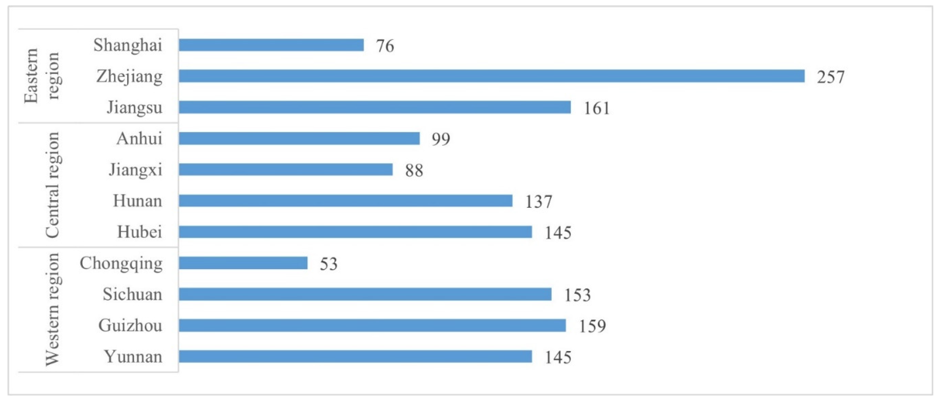
| Geographic Region | Provincial Administrative Region | Folk Literature | Traditional Music | Traditional Dance | Traditional Drama | Quyi | Traditional Sports, Entertainment and Acrobatics | Traditional Arts | Traditional Skills | Traditional Medicine | Folk Customs | Total | Proportion (%) |
|---|---|---|---|---|---|---|---|---|---|---|---|---|---|
| Eastern Region | Shanghai | 2 | 9 | 4 | 7 | 5 | 4 | 10 | 19 | 11 | 5 | 76 | 5.16% |
| Zhejiang | 24 | 15 | 18 | 25 | 28 | 12 | 30 | 54 | 12 | 39 | 257 | 17.45% | |
| Jiangsu | 11 | 21 | 9 | 22 | 10 | 2 | 31 | 38 | 6 | 11 | 161 | 10.93% | |
| Total | 37 | 45 | 31 | 54 | 43 | 18 | 71 | 111 | 29 | 55 | 494 | 33.54% | |
| Central Region | Anhui | 5 | 9 | 10 | 25 | 2 | 4 | 9 | 25 | 3 | 7 | 99 | 6.72% |
| Jiangxi | 1 | 7 | 11 | 17 | 6 | 1 | 11 | 21 | 1 | 12 | 88 | 5.97% | |
| Hunan | 9 | 16 | 13 | 32 | 6 | 4 | 15 | 19 | 6 | 17 | 137 | 9.30% | |
| Hubei | 21 | 28 | 12 | 25 | 13 | 4 | 14 | 10 | 6 | 12 | 145 | 9.84% | |
| Total | 36 | 60 | 46 | 99 | 27 | 13 | 49 | 75 | 16 | 48 | 469 | 31.83% | |
| Western Region | Chongqing | 3 | 14 | 4 | 3 | 6 | 1 | 7 | 7 | 4 | 4 | 53 | 3.60% |
| Sichuan | 7 | 23 | 20 | 11 | 6 | 4 | 25 | 38 | 3 | 16 | 153 | 10.39% | |
| Guizhou | 11 | 20 | 17 | 14 | 3 | 4 | 12 | 31 | 9 | 38 | 159 | 10.80% | |
| Yunnan | 19 | 14 | 30 | 17 | 2 | 2 | 6 | 24 | 6 | 25 | 145 | 9.84% | |
| Total | 40 | 71 | 71 | 45 | 17 | 11 | 50 | 100 | 22 | 83 | 510 | 34.63% |
| Resistance Factor | Resistance Classification | Resistance Value (0–500) | Weight |
|---|---|---|---|
| Land-use type | Shrub land/Wetland | 20 | 0.4665 |
| Waters | 40 | ||
| Forests/grasslands | 60 | ||
| Arable land | 150 | ||
| Bare land/glaciers and firn field | 160 | ||
| Construction land | 200 | ||
| National and provincial highways | 200 | ||
| Highways and railways | 500 | ||
| Elevation (m) | <500 | 30 | 0.2020 |
| 500–1500 | 70 | ||
| 1500–2500 | 100 | ||
| 2500–3500 | 300 | ||
| >3500 | 500 | ||
| Slope (°) | <3 | 5 | 0.2113 |
| 3–8 | 10 | ||
| 8–15 | 30 | ||
| 15–25 | 100 | ||
| >25 | 500 | ||
| geohazard susceptibility | Highly unsusceptible | 30 | 0.1202 |
| roughly unsusceptible | 70 | ||
| moderately susceptible | 100 | ||
| susceptible | 300 | ||
| Highly susceptible | 500 |
Disclaimer/Publisher’s Note: The statements, opinions and data contained in all publications are solely those of the individual author(s) and contributor(s) and not of MDPI and/or the editor(s). MDPI and/or the editor(s) disclaim responsibility for any injury to people or property resulting from any ideas, methods, instructions or products referred to in the content. |
© 2023 by the authors. Licensee MDPI, Basel, Switzerland. This article is an open access article distributed under the terms and conditions of the Creative Commons Attribution (CC BY) license (https://creativecommons.org/licenses/by/4.0/).
Share and Cite
Zhang, T.; Yang, Y.; Fan, X.; Ou, S. Corridors Construction and Development Strategies for Intangible Cultural Heritage: A Study about the Yangtze River Economic Belt. Sustainability 2023, 15, 13449. https://doi.org/10.3390/su151813449
Zhang T, Yang Y, Fan X, Ou S. Corridors Construction and Development Strategies for Intangible Cultural Heritage: A Study about the Yangtze River Economic Belt. Sustainability. 2023; 15(18):13449. https://doi.org/10.3390/su151813449
Chicago/Turabian StyleZhang, Tianxin, Yuliang Yang, Xin Fan, and Shengya Ou. 2023. "Corridors Construction and Development Strategies for Intangible Cultural Heritage: A Study about the Yangtze River Economic Belt" Sustainability 15, no. 18: 13449. https://doi.org/10.3390/su151813449
APA StyleZhang, T., Yang, Y., Fan, X., & Ou, S. (2023). Corridors Construction and Development Strategies for Intangible Cultural Heritage: A Study about the Yangtze River Economic Belt. Sustainability, 15(18), 13449. https://doi.org/10.3390/su151813449