Abstract
The spatial distribution of traditional villages is a key factor for rural revitalization and sustainable development. However, the rapid expansion of cities has resulted in the disappearance and decline of many traditional villages. Therefore, for the protection of traditional villages, it is necessary to analyze the spatio-temporal differentiation characteristics and driving factors. In this study, a total of 500 traditional villages were selected in Shaanxi Province. With the support of spatial analysis tools such as ArcGIS and Geo-detector, the spatial differentiation and its driving factors were analyzed. It was found that traditional villages showed a three-core distribution mode, indicating a typical aggregation distribution of tendency. In Shaanxi, the directional evolution of traditional villages was characterized by a spatial and temporal trajectory toward the north, and then towards the south. In addition, traditional villages existed in areas with underdeveloped economies, far from the cities and close to water sources, with an elevation over 500 m and a slope less than 25°. Traditional villages in Shaanxi Province are experiencing uneven spatio-temporal evolution due to regional cultural differences and uneven economic development in southern, central, and northern areas. It is possible to provide strategies for the development, protection, and utilization of traditional villages and promote the development of rural revitalization based on the traditional villages.
1. Introduction
China has a long farming civilization. Traditional villages are rich in tangible and intangible cultural heritage with historical archaeological, cultural heritage, artistic, and socio-economic values [], which can provide important resources for us to explore the village’s origin, farming civilization, and traditional culture []. The emergence, evolution, and development of traditional villages are not only the specific form of the evolution of farming civilization but also a valuable cultural resource that is not renewable in Chinese civilization [,]. Therefore, the multiple conservation of traditional villages is related to the inheritance and development of traditional cultural diversity []. However, with the rapid development of industrialization and urbanization in the past two decades, traditional villages, agriculture, and farming cultural heritage are gradually disappearing, dying out or being assimilated [,]. Traditional villages face many problems, such as hollowing out of the population, abandonment of farmland, ecological damage, and the aging of traditional buildings []. As a result, the survival space of traditional rural culture is getting narrower, and conservation effects have become exceptionally urgent []. Fortunately, the government and functional departments have taken various measures to promote the effective conservation of traditional villages and rural culture, forming a social consensus on the preservation of traditional villages [].
According to the UNESCO definition, cultural and natural heritage (CNH) are both irreplaceable sources of life and inspiration []. According to the Convention for the Protection of the Architectural Heritage of Europe (Council of Europe, 1985) and the European Landscape Convention (Council of Europe, 2000), the historical rural buildings are considered a cultural subject to conservation []. Cultural heritage in rural areas includes historic rural architecture, village landscapes, and intangible cultural heritage []. However, this unique cultural heritage has been threatened by the economic changes and social and ideological shifts since the mid-1980s []. Therefore, the studies mainly focus on the temporal and spatial evolution of traditional architectural culture and its changing trends [] on the one hand and on the theoretical framework and conservation measures of cultural heritage on the other, especially in countries with a long history [,,].
Since 2012, ‘ancient villages’ have been renamed as ‘traditional villages’ by China’s Traditional Village Protection and Development Research Centre (CTVPDRC). In 2012, the first batch of 646 traditional national villages was released in China []. So far, 6819 traditional Chinese villages have been selected for conservation and redevelopment. Meanwhile, the theme of conservation and reuse of Chinese traditional village heritage resources has attracted extensive attention from academia in the past decade [,]. Many experts and scholars were mainly focused on the conservation of authenticity of traditional village architecture and landscape, spatial distribution characteristics, evolution mechanism, tourism planning, and the development of traditional villages []. However, many achievements have been made in the conservation and value identification of traditional village resources and its influencing factors [,]. Thus, there is still need for a comprehensive study on the role of human activities, internal and external environmental factors, and historical and cultural factors in the conservation and reuse of traditional villages [].
So far, some scholars have concluded that human history, economic conditions, geographical environment, history culture, and policy mechanisms are closely related to the distribution and evolution of traditional villages. For example, the transportation network has been proven to be negatively correlated with the distribution, preservation, and usage of traditional villages [,]. Existing studies have also revealed that traditional villages tend to be far away from large cities or urban agglomerations []. Meanwhile, geographical and environmental factors also play a significant role in the spatio-temporal distribution of villages. Previous studies have revealed that most traditional villages in China, except for those in Yunnan and Tibet areas, are mainly distributed in areas with lower altitude and flat slope [], with a topographic relief ranging from 100 m to 300 m. However, there are still a few traditional villages distributed in high-altitude areas, such as Tongren Tibetan traditional villages in Qinghai Province. Currently, for traditional villages in Shaanxi Province, previous studies mainly focus on the landscape system [], village architecture [], spatial distribution [], specific village structure, and village landscape gene. However, there is a lack of macroscopic and comprehensive analysis, especially for different geographical locations and regional cultures. In summary, there are various types of studies on spatial differentiation and drivers at the regional scale throughout Shaanxi Province []. Therefore, the impact of environmental, socioeconomic, and regional culture on traditional villages, including their preservation, heritage, and utilization, still requires systematic and comprehensive research.
This study was conducted in Shaanxi Province, China, one of the sources of the Chinese nation and Chinese civilization, with 500 traditional villages. However, traditional villages are distributed in different climatic zones, geographical latitudes, and topographical environments, and their spatial evolution is influenced by a combination of multiple factors []. For this reason, it is necessary to understand the spatio-temporal distributions characteristics and driving factors for developing specific strategies for the conservation and development of traditional villages. This study has three main objectives: (1) analyzing the evolutionary trends of spatio-temporal differentiation characteristics of Shaanxi traditional villages using GIS tools and knowledge mapping methods; (2) identifying the main factors driving traditional villages in Shaanxi using geostatistical methods; and (3) supporting decision-making in scientific conservation, rational development, and healthy utilization of Shaanxi traditional villages.
2. Materials and Methods
2.1. Study Area
The traditional villages selected for the study were Shaanxi Province (105°29′–111°15′ E and 31°42′–39°35′ N) (Figure 1a), located in northwestern China, which is usually divided into three parts, including southern Shaanxi, central Shaanxi, and northern Shaanxi, due to its geographical variation. The topography of the southern Shaanxi region is complex and mountainous, with an average elevation between 1000 m and 3000 m. The population density in this region is low, with 121 persons per square kilometer. Their ancestors came here from different areas about 300 years ago to avoid war or famine. Therefore, this region is a mixed place of multiple traditional cultures. The landform of central Shaanxi is plain with an average elevation above 500 m, and the region has a high population density of 300~750 persons per square kilometer. Due to its superior location and proximity to the Weihe River, the region is one of the origins of Chinese civilization. As a result, the region has a long and rich traditional village and rural culture. Northern Shaanxi is a Loess Plateau region with an average altitude of 800 to 1300 m. The region has a lower population density of 57 persons per square kilometer. Historically, this region was a multi-ethnic area, and its traditional houses display unique ethnic styles and local cultural characteristics.
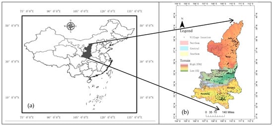
Figure 1.
Geographic location. (a) Map of China. (b) Spatial distribution of traditional villages in Shaanxi Province.
2.2. Data Sources and Processing
There are 182 national-level and 318 provincial-level traditional villages in Shaanxi Province, and all data were used for this study (Figure 1b). The data of traditional villages were taken from the Global Change Science Research Data Release System (http://www.geodoi.ac.cn/WebCn/Default.aspx, accessed on 4 March 2022) and the website of the Department of Urban-Rural and Housing Construction of Shaanxi Provincial (PDURHC) (https://js.shaanxi.gov.cn/, accessed on 4 March 2022). The chronological information of traditional villages was collected from local records of cities and counties in Shaanxi Province, and the location information of traditional villages was obtained from high-definition remote sensing image data (http://www.gscloud.cn/, accessed on 5 March 2022). Furthermore, 30 m DEM elevation data and Landsat TM/ETM+, OLI data were obtained from the geospatial cloud platform (https://www.gscloud.cn/, accessed on 5 March 2022). Socio-economic and human data were obtained from Shaanxi Provincial Statistical Yearbook in 2021 published by the Shaanxi Bureau of Statistics (http://www.shujuku.org/shaanxi-statistical-yearbook.html, accessed on 5 March 2022). Road data were collected from the Historical Atlas of China, edited by Tan Qichang. All traditional village data were formatted and converted to coordinate projection using ArcGIS 10.8 and integrated uniformly into the WGS-84 geographic framework.
In this study, the historical periods were divided into eight periods based on the base time, namely Pre-Qin Dynasty (221 B.C.), Qin-Han Dynasty (221 B.C.–220 A.D.), Wei Jin Southern and Northern Dynasties (220–581 A.D.), Sui Tang and Five Dynasties (581–960 A.D.), Song Liao and Jin Dynasties (960–1279 A.D.), Yuan Dynasty (1279–1368 A.D.), Ming Dynasty (1368–1644 A.D.), and Qing Dynasty (1644–1912 A.D.).
2.3. Methods
2.3.1. Kernel Density Methods
The Kernel density method is a non-parametric model for assessing the probability density distribution of a random variable. The definition of kernel density estimation is as follows:
where denotes the window width, and its value is greater than 0; lim = 0; n denotes the total number of villages in the study area; K(.) stands for a kernel function; xi stands for the coordinate of the i-th village. means the straight-line distance from one village x to another xi. It can be seen that the higher the intensity is, the higher the probability of occurrence is, and vice versa. The values of kernel density were calculated and mapped using ArcGIS 10.8.
2.3.2. Standard Deviation Ellipse
The standard deviation ellipse (SDE) is a model that quantitatively explains the centrality, orientation, and spatial distribution of geographic elements from a spatial perspective based on the location and structure of the object and is used to explore the spatial distribution and evolution process of geographic elements []. An ellipse can provide a simple, bivariate relationship structure [], when a standard deviation ellipse is obtained using a confidence level of one standard deviation [], which can be calculated by the averaging vector values with the following covariance matrix:
where and present the standard deviations, and stands for the correlation coefficient. The central coordinates of the ellipse are defined by , and the principal axes lie in the directions of the eigenvectors Σ []. The principle is shown in Figure 2.
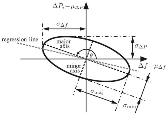
Figure 2.
Standard deviational ellipse.
2.3.3. Spatial Autocorrelation Analysis
Spatial autocorrelation analysis is used to quantitatively describe the spatial dependence of geographic phenomena, which is determined by the global Moran’s index []. This study used Moran’s I index to explore the overall spatial correlation of traditional villages in Shaanxi Province. Its calculation formula is as follows:
where n presents the total number of villages; and are the variables of villages and ; and stands for the spatial weight matrix [,]. The geographic distance matrix is used as follows:
where stands for the distance matrix of geographics, and d presents the distance between village i and j in the limited space, which is usually expressed by the straight line between two villages.
2.3.4. Geo-Detection Model
Spatial differentiation is one of the fundamental features of geographical phenomena. To investigate it, Wang et al. developed a model that could be used to explain the reasons for its formation (Figure 3) []. To explore the spatial correlation between the drivers and the incidence of traditional villages, the distribution pattern map was overlaid with the factor layer to analyze the probability of the influence of the factor on distribution characteristics. It has been proved that the larger the q-value is, the higher the probability of influencing factors on spatial differentiation changes in incidence is []. The differentiation and factor detection model were used, and the q value was calculated as follows:
where h is the total number of the factor X or layer Y; Nb and N are the number of layer and units, and and denote the variables of h and Y. SSW and SST are expressed as sum of squares and total squares, respectively, with q values ranging from 0 to 1. The calculations and statistics were performed by Geo-detector and Python software.
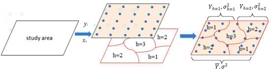
Figure 3.
The principle of the geographical detector.
3. Results
3.1. Spatial Distribution Features of Traditional Villages
The distribution of traditional villages varied greatly among cities in Shaanxi Province. The Moran’s I index for all traditional villages was 0.282, and the Z-value was 4.645 (p = 0.05). Traditional villages were unevenly distributed, mainly in Ankang, Hanzhong, Weinan, Yan’an, and Yulin cities, accounting for 80% of the total in Shaanxi Province (Table 1), while Xi’an and Tongchuan cities had the least, accounting for only 2%, indicating that traditional villages in Shaanxi Province are spatially clustered (Figure 4).

Table 1.
Statistical results of different traditional villages in major cities.
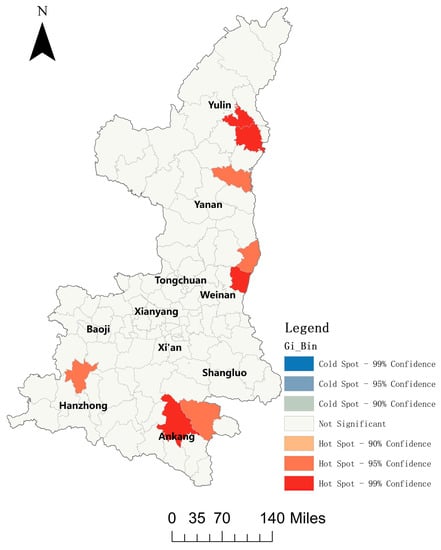
Figure 4.
Local Getis-ord Gi* index of traditional villages in Shaanxi province.
Figure 5 shows a trend of SDE coordinate centers from 109°37′ E, 35°17′ N in the Pre-Qin period to 109° 27′ E, 36°2′ N in the Song, Liao, and Jin periods and then to 109°13′ E, 34°22′ N in the Qing period. The east–west span from Pre-Qin to Song, Liao, and Jin is about 0.1°, and the south–north span is about 1.03°, which shows a distribution trend of traditional villages migration from south to north in this period. The east–west span from Song, Liao, and Jin to Qing is about 0.14°, and the north–south span is about 1.98°. The results show that the traditional village changes in this period showed a migration trend from central Shaanxi to northern Shaanxi and then to southern Shaanxi. We can see clearly that the spatial distribution of traditional villages in Shaanxi Province in different historical periods is relatively concentrated.
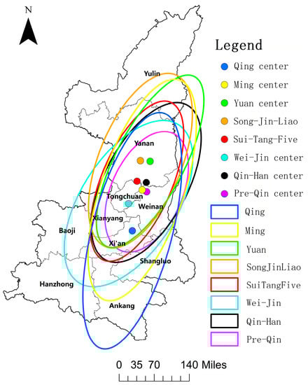
Figure 5.
Standard deviation ellipse and its center of traditional villages in Shaanxi province.
3.2. Evolution of Spatio-Temporal Pattern of Traditional Villages
The results of the study on the kernel density of traditional villages in Pre-Qin period show that two significant cores were formed in the northwestern and northeastern parts of Weinan city in Shaanxi Province, and the kernel density results were greater in the northwestern part than those in the northeastern part (Figure 6a). During the Qin–Han dynasties, traditional villages are mainly located in Yan’an, the eastern part of Weinan and the Xianyang city (Figure 6b). During the Wei, Jin, and North and South Dynasties, the number of villages decreased dramatically due to frequent wars and regime changes. Thus, traditional villages in this period were mainly located in the northeast part of Yan’an city and the eastern part of Weinan city (Figure 6c). Then, traditional villages in the Sui, Tang, and Five Dynasties periods were mostly concentrated in the south of Yan’an city (Figure 6d), and traditional villages have been centered around the southeastern part of Yulin city during the Song, Liao, Jin, and Yuan dynasties (Figure 6e,f). The kernel density results of traditional villages also show that the number of villages increased rapidly during the Ming Dynasty, and most of them were mainly concentrated in the southeastern part of Yulin city, the northeastern part of Weinan city, and the western part of Ankang city (Figure 6g). By the Qing Dynasty, the number of traditional villages increased significantly, mainly in the central part of Ankang city (Figure 6h). In contrast, traditional villages in other regions are generally distributed in a low density. Further statistics revealed that the number of traditional villages in Shaanxi Province in different historical periods from the Pre-Qin to Qing Dynasties were 34, 23, 28, 38, 33, 25, 141, and 149, respectively.
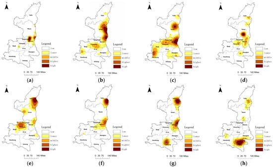
Figure 6.
Kernel density distribution of traditional villages in different periods. (a) Pre-Qin, (b) Qin–Han, (c) Wei–Jin, (d) Sui–Tang–Five, (e) Song–Jin–Liao, (f) Yuan, (g) Ming, (h) Qing.
In addition, the evolutionary characteristics of the spatio-temporal pattern of traditional villages in Shaanxi Province were further explored through the motion trajectory method combination with the knowledge mapping theory. The results indicate that the spatial pattern of traditional villages in different historical periods ranged from the central Shaanxi region in the Pre-Qin period (Figure 7a), to the central-northern Shaanxi region in the Qin–Han and Wei–Jin–North and South Dynasties periods (Figure 7b,c), to the central Shaanxi region in the Sui–Tang and Five Dynasties periods (Figure 7d), to the northern Shaanxi region in the Song–Liao–Jin–Yuan period (Figure 7e,f), and finally to the southern Shaanxi region in the Ming–Qing period (Figure 7g,h).
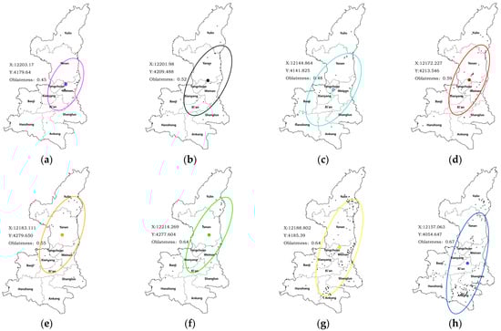
Figure 7.
Spatial and temporal knowledge map of traditional villages in Shaanxi province. (a) Pre-Qin, (b) Qin–Han, (c) Wei–Jin, (d) Sui–Tang–Five, (e) Song–Jin–Liao, (f) Yuan, (g) Ming, (h) Qing.
3.3. Driving Factors of Traditional Villages
3.3.1. Detection of Driving Factors
To further explore the driving factors of the spatial distribution of traditional villages in Shaanxi Province, six influencing factors (elevation as X1, slope as X2, river as X3, ancient transportation as X4, distance from the central city as X5, and urban GDP as X6) were selected as independent variables based on the Geo-detection analysis method for spatio-temporal differentiation of Shaanxi traditional villages (Table 2). The results showed that there were significant differences among the selection factors. Urban GDP was the decisive factor for the spatio-temporal changes in traditional villages, while altitude, river, and distance from the central city were also important driving factors for Shaanxi traditional villages. However, factors such as slope and ancient transportation did not pass the significance test, and whether the reasons are closely related to the sample size needs to be further verified.
Table 2.
Results of driving factors detection of Shaanxi traditional villages distribution.
3.3.2. Physical Factors of Traditional Villages
(1) Altitude
Altitude is an important factor and indicator for quantitative research on traditional villages. Therefore, to quantitatively evaluate the effects of altitudes on the spatial distribution features of Shaanxi traditional villages, the surface analysis slope tool and the reclassification by natural break tool were used to explore the distribution pattern (Figure 8). We concluded that only 85 traditional villages were distributed at altitudes lower than 500 m, accounting for about 17%. In addition, 83% of the traditional villages are located in areas above 500 m above sea level; especially, 170 traditional villages were scattered more than 1000 m above sea level, accounting for 34%. Therefore, it can be concluded that the higher the altitude is, the greater the number of traditional villages is, indicating that the spatial distribution of traditional villages in Shaanxi Province is positively correlated with altitude.
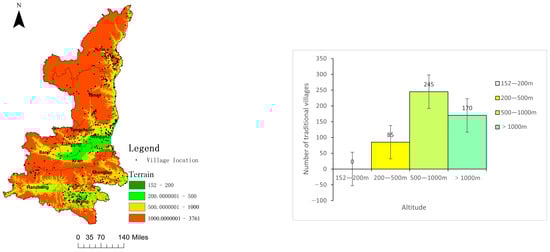
Figure 8.
Spatial relationship between altitude and the distribution of traditional villages.
(2) Slope
To explore the spatial distribution correlation between slope and traditional villages in Shaanxi Province, we extracted slope parameters using the ArcGIS 10.8 slope analysis too, reclassified them according to the slope criteria of construction land, and then overlaid them on the traditional village distribution map (Figure 9). The results show that 69 traditional villages are located in a moderate zone with slope less than 10°; 58 traditional villages are located in the zone with slope of 10–15°, accounting for 11.6% of the total. Meanwhile, we also found that 163 and 108 traditional villages are located on high slopes between 15–20° and 20–25°, accounting for 32.6% and 21.6%, respectively. The number of traditional villages with slope greater than 25° is 102, accounting for 20.4% of the total. Therefore, 373 traditional villages with slopes greater than 15°, accounting for 74.6%, are located in the northern and southern Shaanxi regions, indicating that traditional villages in Shaanxi Province tend to be situated on high-gradient slopes, especially in the Qinba mountains in southern Shaanxi and the Loess Plateau in northern Shaanxi areas.
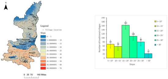
Figure 9.
Spatial relationship between slope and the distribution of traditional villages.
(3) River
We used the ArcGIS 10.8 spatial analysis buffer tool to obtain river maps and overlay them on the traditional village distribution layer (Figure 10). The results show that the traditional villages in Shaanxi Province are mainly distributed along these rivers; especially, 25%, 24%, and 35% of the total number are mainly distributed along the Wuding River, Weihe River, and Hanjiang, and others are located near the Luohe River and Jinghe River. It can be concluded that 61, 226, and 242 traditional villages are distributed within 1000 m, 2000 m, and 3000 m of rivers, accounting for 12%, 45%, and 48%, respectively. Overall, the distribution of traditional villages near water resources was clustered and mostly set in mountains areas. This is consistent with the findings of Chen Qiaoting et al.
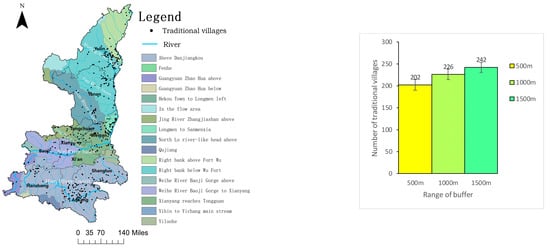
Figure 10.
Spatial relationship between river and the distribution of traditional villages.
Meanwhile, the correlation between waterway traffic and the distribution of traditional villages was analyzed (Table 3). The results showed that more than 45% of the villages were located within 1000 m of the rivers, especially in the Song, Liao, and Jin, Qin–Han, and Wei–Jin dynasties, accounting for 60%, 52%, and 50%, respectively. The findings also reveal the importance of waterways in ancient transportation, which can be used to further explain the necessity of traditional villages being built close to waterways.
Table 3.
Distance between traditional villages and rivers in different historical periods.
3.3.3. Socio-Economic Factors of Traditional Villages
(1) Ancient transportation
The natural breaks method was used to classify the major road networks in Shaanxi Province, and then, it was superimposed on the traditional village layer (Figure 11). As shown in Figure 11, the results show that 162 traditional villages are located within the 10 km buffer zone of ancient post roads in Shaanxi Province, accounting for 32.4% of the total, while the remaining 338 traditional villages are distributed outside the 10 km buffer zone, accounting for 67.6%. One may conclude that the choice of location of traditional villages in Shaanxi Province is not entirely around the ancient post roads, and only a few traditional villages are found to be concentrated around the ancient portage route, accounting for about 25% of the total. For example, the villages of Mizhi and Suide Counties are clustered at the intersection of the Suide ancient portage route. This spatial phenomenon suggests that they seldom considered the traffic of the ancient portage route when they first established the villages. This may be because the traffic of ancient post roads was built later according to the distribution of villages and the convenience of landforms.
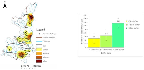
Figure 11.
Spatial relationship between ancient post road and the distribution of traditional villages.
(2) Distance from the Central city
For analyzing the correlation between traditional villages and the nearest central cities. We selected 10 cities as the central cities in Shaanxi and used the ArcGIS 10.8 software to calculate the straight-line distance to the central cities using the network distance algorithm. As shown in Figure 12, the buffer distances established for each major city were 30 km, 60 km, 90 km, and 120 km, respectively. The results show that there are only 52 and 86 traditional villages within a radius of 30 km and 60 km from the major cities, accounting for 10.4% and 17.2%, respectively, which indicates that most of which are far from the central cities. Further statistical analysis reveals that there are 362 villages located more than 60 km away from major cities, accounting for 72.4%, indicating that the Shaanxi traditional villages are mainly located in remote areas, which are less affected by modern industrial civilization and are conducive to the preservation and inheritance of the original appearance and characteristics of traditional villages.
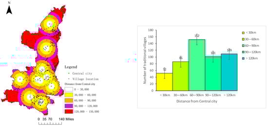
Figure 12.
Distribution of distance between traditional villages and central cities in Shaanxi province.
(3) City GDP
According to Figure 13, regional GDP and the number of traditional villages fluctuate. About 78% of traditional villages are located in regions with GDPs below 250 billion RMB; Weinan, Yan’an, and Ankang only account for 76%, 65%, and 46% of the province’s average GDP. However, the number of traditional villages is more distributed in these regions, accounting for 19.6%, 13.6%, and 18.8%, respectively. According to this study, the majority of traditional villages in Shaanxi Province are located in relatively underdeveloped economic areas and are relatively unaffected by external economic influences. This can provide a solid foundation for the preservation and retention of the material elements, cultural customs, and lifestyles of traditional villages.
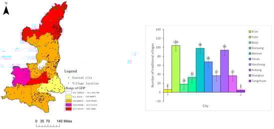
Figure 13.
Relationship between gross product of prefecture-level cities and traditional villages in Shaanxi province.
4. Discussion
4.1. Spatial Distribution and Evolution Characteristics of Traditional Villages
The traditional villages always showed an unbalanced spatial distribution pattern [,] and an agglomeration distribution tendency [,,]. In this study, the results show that the spatial distribution of traditional villages in Shaanxi Province and their evolution process follow heterogeneous and non-equilibrium characteristics. As depicted in Figure 4, Figure 5 and Figure 6, traditional villages are unevenly located and mainly distributed in the cities of Weinan, Ankang, Yulin, and Yan’an in Shaanxi Province, which is consistent with the conclusions of Xu Juan et al. [,]. According to historical records, Baishui County in Weinan was established in the middle of the Warring States period, the 12th year of Qin Xiaogong (350 BC), and Hancheng, known as Longmen in ancient times, was established in the Western Zhou period. Subsequently, Xiayang County was established during the Warring States period and has a rich history. In contrast, some traditional villages exist around Xianyang, the capital city in China, which has a more concentrated population and a higher level of productivity. As China’s political, economic, and cultural center during the Qin–Han dynasties, Xianyang city was also located along the Weihe River and surrounded by fertile soil that could provide sufficient food for the indigenous populations. After the Qin–Han dynasties, during the Song, Liao, Jin, and Yuan dynasties, the northern part of Shaanxi was occupied by the Western Xia state, which led to a concentration of population and a long-term period of economic prosperity in the region. Therefore, during this period, traditional villages were mainly concentrated in the southern part of Yan’an, a geographically privileged area with abundant water resources and fertile land for their survival [,].
The Sui town in the Yulin region and Sui De Wei in the fourth year of Hongwu (1371) were established during the Ming Dynasty to defend against the Mongol invasion from the north. As a result, it attracted a large number of people to gather, leading to the establishment of many traditional villages. Meantime, some traditional villages in the Qinba Mountains, including the Hanyin and Ankang areas, were established to make a living or escape from war, some of them mainly by rebels who lost the war and others probably from famine in other areas. During the late Ming and early Qing dynasties, war and natural and man-made disasters led to a sharp decline in population in southern Shaanxi, resulting in widespread land desolation and stagnant agricultural development []. To avoid land desolation, protect fiscal revenue, and stabilize the early Qin regime, the Qing government took a series of measures to increase the population and reclaim land in southern Shaanxi after the war []. In the middle of the Qing Dynasty, southern Shaanxi became the main migration area in the country, dominated by populations from Huguang, Fujian, and Guandong, and a large number of formal and informal migrants poured into Qinba Mountains, leading to a dramatic expansion of land reclamation, changes in production methods, and an increasing number of villages []. This result agrees well with previous studies by Zhang and Xiang [,]. Therefore, it can be concluded that the historical evolutionary pattern of traditional villages in Shaanxi Province was mainly influenced by a combination of economic, political, cultural, and social factors at the time [].
4.2. Multiple Factors Jointly Affect Traditional Villages
Traditional villages are always influenced by natural factors such as elevation, topography [,], as well as human, economic, and social development factors such as population and ethnic composition [,,,]. A positive correlation was found between traditional villages and the level of economic development, population, and human history, while a negative correlation was found between transportation networks [,,]. The results show that the traditional villages present diverse characteristics depending on where they are found, and these characteristics are shaped by the environment, geography, and human activities. From an economic perspective, municipal GDP is a decisive factor in the spatio-temporal differentiation of traditional villages in Shaanxi Province. The unbalanced economic development and the preservation and inheritance of traditional villages are more favorable in areas that are less regional and less influenced by the outside world, in line with the previous studies conducted by Xu et al. []. Distance from the central city is another important factor affecting the spatio-temporal differentiation of traditional villages, and villages far from the central city are more conducive to conservation and inheritance []. Ancient transportation also has an impact on the spatio-temporal differentiation of traditional villages. In the narrow geography of Shaanxi, ancient post roads were the only land transportation connecting the northern and southern regions. Therefore, a few traditional villages were distributed at the intersection of ancient post roads [].
In Shaanxi Province, altitude is an important influencing factor for the spatio-temporal differentiation of traditional villages. These villages are mainly found in areas above 500 m in altitude, which is inseparable from the region’s topography []. The topography of Shaanxi Province can be divided into three major parts, including the Loess Plateau, the Guanzhong Plain, and the Qinba Mountains, which are positioned in the northern, central, and southern parts of Shaanxi Province, respectively. More than three-quarters of the land in Shaanxi Province is plateau and mountains, which leads to the fact that many traditional villages are necessarily distributed in higher altitude areas [,,]. In addition, rivers have influenced the spatio-temporal differentiation of traditional villages []. Most traditional villages have obvious characteristics of distribution along rivers, with obvious clustering phenomena in the Wuding River, Wei River, and Han River. This suggests that water was a major factor of concern for the ancients in selecting village sites. These findings are in agreement with previous studies by Lin [] and Fu []. Finally, slope also has a degree of influence on the spatio-temporal differentiation of traditional villages [,], and the results show that most of the traditional village sites are located in the relatively flatter areas in the plateau mountains.
4.3. The Influence of Culture on Traditional Villages
The spatio-temporal distribution of traditional villages is influenced not only by natural and economic conditions but also by the traditional culture of the region [,]. It is well known that Shaanxi has a vast territory and a long cultural history []. From a historical perspective, Shaanxi’s regional culture can be divided into three major segments: southern Shaanxi culture, central Shaanxi culture, and northern Shaanxi culture. Combined with the “hotspot” analysis, the distribution of Shaanxi traditional villages shows a “three-core” pattern, representing the three regional cultural characteristics of Ankang in southern Shaanxi, Weinan in central Shaanxi, and Yulin in northern Shaanxi, respectively.
Located at the intersection of Bashu, Jingchu, Qinlong, and Central Plains cultures, Ankang culture has a strong personality and uniqueness due to its unique geographical location. Thus, Ankang people do not respect the ethical relationship of farming culture, whereas the natural view of Taoist culture has a profound influence on them, and the footprints left by Taoist figures can be seen everywhere in the large and small market towns of Ankang, such as Nuwa, Emperor Shun, Zen Master Huaijan, and Zhang Boduan, a real man of Ziyang. Most of the traditional villages in the area date from the Ming and Qing dynasties, and the unique Taoist culture of Ankang was also an important reason for attracting many people to gather in the context of the migration wave at that time. It can be seen that the unique culture of Ankang is an important reason for the gathering of many ancient villages with special characteristics in the areas.
Weinan, bordered by the Qinling Mountains to the south and the Yellow River to the east, has undergone many ethnic fusions throughout its history and has developed a unique regional culture. Since the Zhou, Qin, Han, and Tang dynasties, Weinan has been a major town of the three Qin dynasties, a thoroughfare for eight provinces, an important capital city, and always a place of contention for soldiers. Cangjie, Sima Qian, Yang Jian, Bai Juyi, and Sima Guang are some of the most famous figures in history, most of which are mostly concentrated in Hancheng City and Heyang County, which have appeared since the Pre-Qin period and reached their peak during the Ming period. Traditional villages with various characteristics gathered here have been nourished by the regional culture of Weinan and have continued to this day.
Shaanxi has been influenced by a diverse range of cultures throughout its history. Every social change has created conditions for inter-ethnic exchanges and intermingling, allowing different cultures to learn from one another and integrate []. Suide and Mili are the birthplaces of northern Shaanxi culture, originating in the Pre-Qin period, and the number of traditional villages increased significantly in the Ming and Qing dynasties, which coincides with the history of the development of regional culture in northern Shaanxi. Fan Zhongyan, Sima Guang, and Han Shizhong had personally visited Suide and commanded it, leaving behind many relevant poems and articles passed down to the world. Mink and Li Zicheng and other historical celebrities were born in Mizhi. It can be seen that the special regional culture has left many traditional villages with rich cultural connotations and long-term histories in the area of Mizhi and Suide.
4.4. Protection Policies
Consequently, the regional traditional culture of Shaanxi Province has been instrumental in bringing together a large population, as well as promoting the development of regional traditional villages, resulting in the “three core” pattern of traditional village distribution in Shaanxi Province. In order to further protect the heritage of these traditional villages, the PDURHC released the protection plan for Shaanxi Traditional Villages in 2019. In Shaanxi, traditional villages will be protected in four aspects, including a protection system, planning, strengthening the protection and inheritance of cultural heritage, and improving infrastructure and cultivating characteristic industries to ensure a reasonable and scientific inheritance protection [,]. Meanwhile, it should be combined with the rural revitalization strategy, focusing on digital protection, connotative excavation, and deep application development of traditional architecture and cultural heritage, while balancing historical and cultural preservation with industrial development and following the development ideas of protection, innovation, perseverance, and integration [,,]. Under the premise of achieving digital protection of all elements of traditional village heritage, leapfrogging development must be achieved while implementing all-round protection in conjunction with rural revitalization and construction of historical and cultural cities [,,,].
It should be noted that the formation, evolution, and development of traditional villages are influenced by a combination of multidimensional factors [,]. In this study, the spatio-temporal differential distribution characteristics and driving factors on a regional scale were only analyzed, which can provide a theoretical foundation for the conservation and development of traditional villages. Nevertheless, this study did not excavate the interior conditions, internal village features, and architectural structure of traditional villages. As a result, further research on traditional villages needs to focus on spatial morphology, genetic genealogy, intra-village space, and architectural structure characteristics.
5. Conclusions
In this study, the spatio-temporal variations of Shaanxi traditional village distributed characteristics and driving factors were analyzed. The main conclusions are as follows.
First, it is found that traditional villages in Shaanxi Province have uneven spatial characteristics. Villages far from central cities are more conducive to preservation and inheritance and are mainly found in areas with an altitude above 500 m, a slope of less than 25 degrees, and a water supply. Overall, there are three spatial agglomerations in southern, central, and northern Shaanxi Province. The directional evolution and migration trends of traditional villages show a spatio-temporal trajectory from the center to the northern part and finally to the southern part of Shaanxi.
Second, the evolutionary patterns and spatial clustering of traditional villages are the results of the long-term interaction of multiple factors. The majority of traditional villages in Shaanxi Province are located in economically underdeveloped areas that are uninfluenced by external factors. Regional cultural differences and unbalanced economic development in southern, central, and northern Shaanxi areas are the root causes of the uneven spatio-temporal evolutionary process of Shaanxi traditional villages.
Finally, this study mainly focuses on the spatio-temporal distribution characteristics and the influence mechanism of multi-factors of Shaanxi traditional villages, which can be used as a basis for policy-making on the conservation, utilization, and sustainable revitalization of traditional villages. However, the spatial morphology, genetics, and architectural characteristics of traditional villages at micro-level are not considered and need further studies in the future.
Author Contributions
Conceptualization, X.F.; methodology, M.H.; formal analysis, X.F., M.H. and S.S.; investigation, X.B., Z.Z., M.L. and F.L.; resources, M.L., M.H. and X.B.; writing—original draft preparation, X.F.; writing—review and editing, X.F., S.S., M.H., M.L., Z.Z., Y.W. and X.B.; visualization, M.H. and Y.W.; supervision, X.F.; project administration, X.F. and M.H.; funding acquisition, X.F. and F.L. All authors have read and agreed to the published version of the manuscript.
Funding
This research was funded by National Natural Science Foundation of China, grant number 51608419, Natural Science Foundation of Shaanxi Province, grant number 2018JM5073, and Scientific Research Foundation of Xi’an University of Architecture and Technology, grant number ZR19001.
Institutional Review Board Statement
Not applicable.
Informed Consent Statement
Not applicable.
Data Availability Statement
The data presented in this study are available on per request to the corresponding author.
Conflicts of Interest
The authors declare no conflict of interest.
References
- Bian, J.J.; Chen, W.X.; Zeng, J. Spatial Distribution Characteristics and Influencing Factors of Traditional Villages in China. Int. J. Environ. Res. Public Health 2022, 19, 4627. [Google Scholar] [CrossRef] [PubMed]
- Chen, X.H.; Xie, W.Z.; Li, H.B. The spatial evolution process, characteristics and driving factors of traditional villages from the perspective of the cultural ecosystem: A case study of Chengkan Village. Habitat Int. 2020, 104, 102250. [Google Scholar] [CrossRef]
- Xie, X.B.; Li, X.J. The formation and transformation of “Cultural Matrix” in traditional villages. J. Hunan Univ. (Soc. Sci.) 2019, 33, 126–133. [Google Scholar]
- Xu, Y.Q.; Yang, X.Y.; Feng, X.H.; Yan, P.; Shen, Y.; Li, X.L. Spatial distribution and site selection adaptation mechanism of traditional villages along the Yellow River in Shanxi and Shaanxi. River Res. Appl. 2022, 1–13. [Google Scholar] [CrossRef]
- Gao, C.G.; Wu, Y.; Bian, C.L.; Gao, X.X. Spatial characteristics and influencing factors of Chinese traditional villages in eight provinces the Yellow River flows through. River Res. Appl. 2021, 1–15. [Google Scholar] [CrossRef]
- Ma, H.D.; Tong, Y.Q. Spatial differentiation of traditional villages using ArcGIS and GeoDa: A case study of Southwest China. Ecol. Inform. 2022, 68, 101416. [Google Scholar] [CrossRef]
- Long, H.L.; Tu, S.S.; Ge, D.Z.; LI, T.T.; Liu, Y.S. The allocation and management of critical resources in rural China under restructuring: Problems and prospects. J. Rural Stud. 2016, 47 Pt B, 392–412. [Google Scholar] [CrossRef]
- Wang, B.; Shi, W.Z.; Miao, Z.L. Confidence Analysis of Standard Deviational Ellipse and Its Extension into Higher Dimensional Euclidean Space. PLoS ONE 2015, 10, e0118537. [Google Scholar] [CrossRef]
- Ma, Y.; Huang, Z.X. Research on spatial distribution and accessibility of the traditional villages in the urban agglomeration on the middle reaches of the yangtze river based on GWR model. Hum. Geogr. 2017, 32, 78–85. [Google Scholar]
- Barrientos, F.; Martin, J.; Luca, C.D.; Tondelli, S.; Gómez-García-Bermejo, J.; Casanova, E.Z. Computational methods and rural cultural & natural heritage: A review. J. Cult. Herit. 2021, 49, 250–259. [Google Scholar] [CrossRef]
- Sardaro, R.; Sala, P.L.; Pascale, G.D.; Facclongo, N. The conservation of cultural heritage in rural areas: Stakeholder preferences regarding historical rural buildings in Apulia, southern Italy. Land Use Policy 2021, 109, 105662. [Google Scholar] [CrossRef]
- Amit-Cohen, L.; Sofer, M. Cultural heritage and its economic potential in rural society: The case of the kibbutzim in Israel. Land Use Policy 2016, 57, 368–376. [Google Scholar] [CrossRef]
- Palombini, A. Storytelling and telling history. Towards a grammar of narratives for Cultural Heritage dissemination in the Digital Era. J. Cult. Herit. 2017, 24, 134–139. [Google Scholar] [CrossRef]
- Quintana, D.C.; Díaz-Puente, J.M.; Gallego-Moreno, F. Architectural and cultural heritage as a driver of social change in rural areas: 10 years (2009–2019) of management and recovery in Huete, a town of Cuenca, Spain. Land Use Policy 2022, 115, 106017. [Google Scholar] [CrossRef]
- Bender, O.; Boehmer, H.J.; Jens, D.; Schumacher, K.P. Using GIS to analyze long-term cultural landscape change in Southern Germany. Landsc. Urban Plan. 2005, 70, 111–125. [Google Scholar] [CrossRef]
- Wang, D.G.; Zhu, Y.J.; Zhao, M.F.; Lv, Q.Y. Multi-dimensional hollowing characteristics of traditional villages and its influence mechanism based on the micro-scale: A case study of Dong cun Village in Suzhou, China. Land Use Policy 2022, 101, 105146. [Google Scholar] [CrossRef]
- Ju, X.X.; Yang, C.C.; Zhao, M.W.; Xu, Y.; Zhou, D.M.; Zhang, Y.W. Spatial Distribution Characteristics and Influencing Factors of Traditional Villages in Zhejiang, Anhui, Shaanxi, Yunnan Provinces. Econ. Geogr. 2022, 42, 222–230. [Google Scholar]
- Xu, J.; Yang, M.S.; Hou, C.P.; Lu, Z.L.; Liu, D. Distribution of rural tourism development in geographical space: A case study of 323 traditional villages in Shaanxi, China. Eur. J. Remote Sens. 2021, 54 (Suppl. S2), 318–333. [Google Scholar] [CrossRef]
- Xue, M.Y.; Wang, C.X.; Dou, W.S.; Wang, Z.H. Spatial distribution characteristics of traditional villages in the Yellow River basin and influencing factors. J. Arid Land Resour. Environ. 2020, 34, 94–99. [Google Scholar] [CrossRef]
- Li, L.L.; Zhang, J.Q. Image simulation of traditional villages Spatial layout based on Computer Numerical Analysis. Mob. Inf. Syst. 2022, 2022, 5873846. [Google Scholar] [CrossRef]
- Fu, J.; Zhou, J.L.; Deng, Y.Y. Heritage values of ancient vernacular residences in traditional villages in Western Hunan, China: Spatial patterns and influencing factors. Build. Environ. 2021, 188, 107473. [Google Scholar] [CrossRef]
- Liu, C.; Cao, Y.J.; Yang, C.; Zhou, C.; Ai, M.C. Pattern identification and analysis for the traditional village using low altitude UAV-borne remote sensing: Multifeatured geospatial data to support rural landscape investigation, documentation and management. J. Cult. Herit. 2020, 44, 185–195. [Google Scholar] [CrossRef]
- Zheng, X.Y.; Wu, J.H.; Deng, H.B. Spatial Distribution and Land Use of Traditional Villages in Southwest China. Sustainability 2021, 13, 6326. [Google Scholar] [CrossRef]
- Pei, Y.F.; Gong, K.; Leng, J.W. Study on the inter-village space of a traditional village group in Huizhou Region: Hongguan Village group as an example. Front. Archit. Res. 2020, 9, 588–605. [Google Scholar] [CrossRef]
- Hardle, W.; Simar, L. Applied Multivariate Statistical Analysis, 22nd ed.; Springer: Berlin, Germany, 2007. [Google Scholar]
- He, Y.B.; Zhang, T.; Xiong, D.M. Evaluation on cultural value of traditional villages and differential revitalization: A case study of Jiaozuo City, Henan Province. Econ. Geogr. 2020, 40, 230–239. [Google Scholar]
- Gao, J.; Wu, B.H. Revitalizing traditional villages through rural tourism: A case study of Yuanjia Village, Shaanxi Province, China. Tour. Manag. 2017, 63, 223–233. [Google Scholar] [CrossRef]
- Chen, Y.G. An analytical process of spatial autocorrelation functions based on Moran’s index. PLoS ONE 2021, 16, e0249589. [Google Scholar] [CrossRef]
- Chen, Y.G. New framework of GetisOrd’s indexes associating spatial autocorrelation with interaction. PLoS ONE 2020, 15, e0236765. [Google Scholar] [CrossRef]
- Wang, J.F.; Zhang, T.L.; Fu, B.J. A measure of spatial stratified heterogeneity. Ecol. Indic. 2016, 67, 250–256. [Google Scholar] [CrossRef]
- Song, B.; Ren, Y.Y.; Feng, M. Spatial Characteristics and Influencing Factors of Traditional Villages in Loess Plateau Gully Area: A Case of National Traditional Villages in Yulin City of Shaanxi Province. Areal Res. Dev. 2021, 40, 162–168. [Google Scholar]
- Zhang, P.; Li, J.; Zhang, Z.H. Spatial-Temporal Distribution Characteristics and Influencing Factors of Traditional Villages in Qinling-Daba Mountains. J. Hum. Settl. West China 2020, 25, 116–124. [Google Scholar]
- Xiang, Y.L.; Cao, M.M.; Yan, F.; Sun, F. Study on Spatio-temporal Characteristics and Protection Strategies of Traditional Villages in Shaanxi Province. Urban Stud. 2019, 26, 27–31. [Google Scholar]
- Filloramo, R.; Becker, V.; Curci, A. Apulian prehistoric community connections: Preliminary results of GIS analysis and field activity. J. Archaeol. Sci. Rep. 2020, 32, 102380. [Google Scholar] [CrossRef]
- Yang, Y.; Hu, J.; Liu, D.J.; Li, Y.J.; Chen, Y.; Hu, S.L. Spatial differentiation of ethnic traditional villages in Guizhou province and the influencing factors. J. Arid Land Resour. Environ. 2022, 36, 178–185. [Google Scholar]
- Lin, M.S.; Jian, J.S.; Yu, H.; Zeng, Y.F.; Lin, M.L. Research on the Spatial Pattern and Influence Mechanism of Industrial Transformation and Development of Traditional Villages. Sustainability 2021, 13, 8898. [Google Scholar] [CrossRef]
- Fu, X.L. Cognitive research on spatial morphology of traditional villages based on ecological perspective. Fresenius Environ. Bull. 2021, 30, 2285–2289. [Google Scholar]
- Yang, X.; Song, K.; Pu, F.A. Laws and Trends of the Evolution of Traditional Villages in Plane Pattern. Sustainability 2020, 12, 3005. [Google Scholar] [CrossRef]
- Nie, Z.Y.; Li, N.; Pan, W.; Yang, Y.S.; Chen, W.; Hong, C.L. Quantitative Research on the Form of Traditional Villages Based on the Space Gene-A Case Study of Shibadong Village in Western Hunan, China. Sustainability 2022, 14, 8965. [Google Scholar] [CrossRef]
- Li, T.; Li, C.K.; Zhang, R.; Cong, Z.; Mao, Y. Spatial heterogeneity and influence factors of traditional villages in the Wuling Mountain area, Hunan Province, China based on Multiscale Geographically Weighted Regression. Buildings 2023, 13, 294. [Google Scholar] [CrossRef]
- Li, S.Y.; Song, Y.H.; Xu, H.; Li, Y.J.; Zhou, S.K. Spatial distribution characteristics and driving factors for traditional villages in areas of China based on GWR Modeling and Geodetector: A case study of the Awa Mountain Area. Sustainability 2023, 15, 3443. [Google Scholar] [CrossRef]
- Lu, Y.; Ahmad, Y. Heritage protection perspective of sustainable development of traditional villages in Guangxi, China. Sustainability 2023, 15, 3387. [Google Scholar] [CrossRef]
Disclaimer/Publisher’s Note: The statements, opinions and data contained in all publications are solely those of the individual author(s) and contributor(s) and not of MDPI and/or the editor(s). MDPI and/or the editor(s) disclaim responsibility for any injury to people or property resulting from any ideas, methods, instructions or products referred to in the content. |
© 2023 by the authors. Licensee MDPI, Basel, Switzerland. This article is an open access article distributed under the terms and conditions of the Creative Commons Attribution (CC BY) license (https://creativecommons.org/licenses/by/4.0/).