
Mapping Freshwater Aquaculture’s Diverse Ecosystem Services with Participatory Techniques: A Case Study from White Lake, Hungary


Abstract
1. Introduction
2. Database
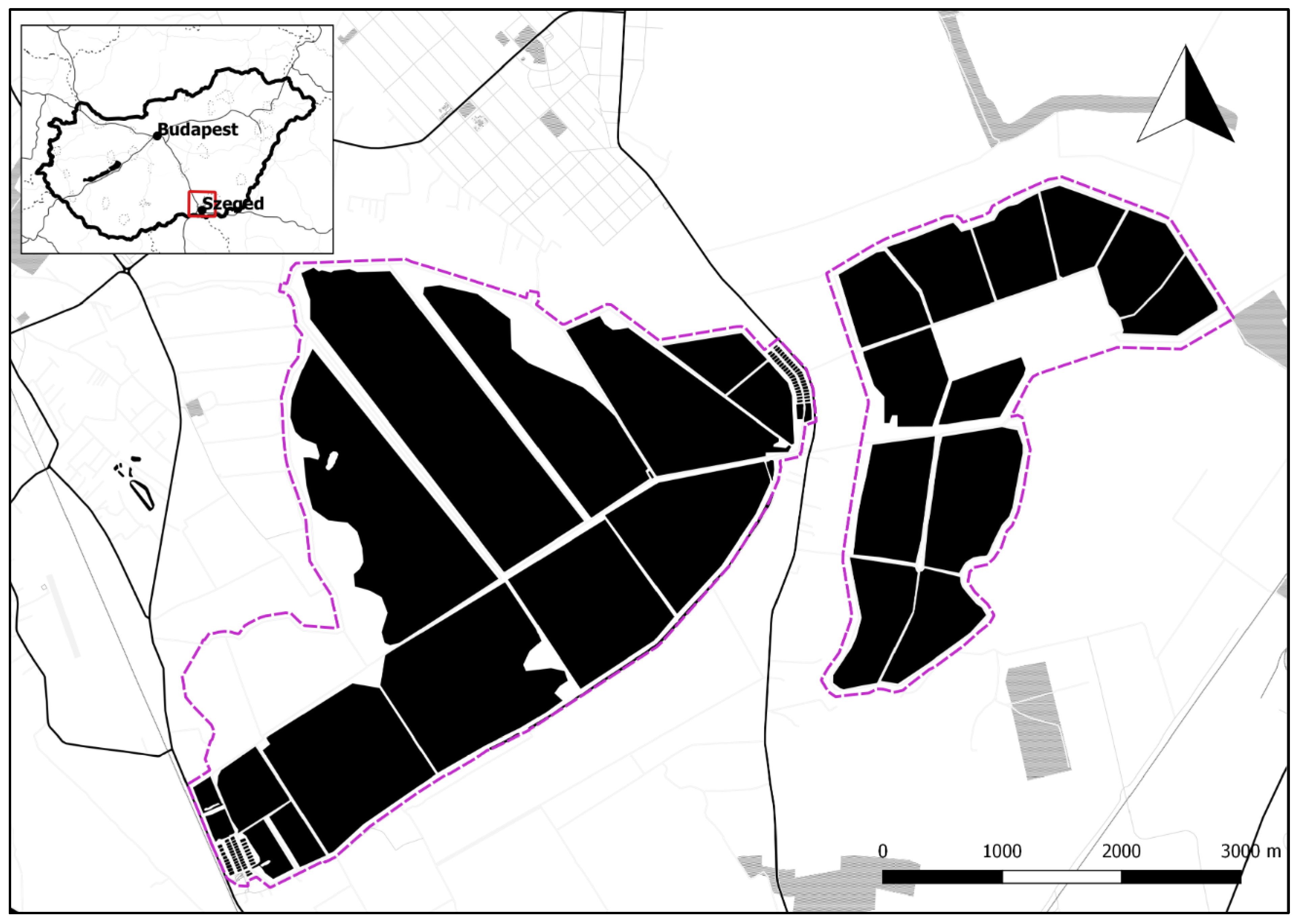
2.1. Study Area
2.2. List of Ecosystem Services
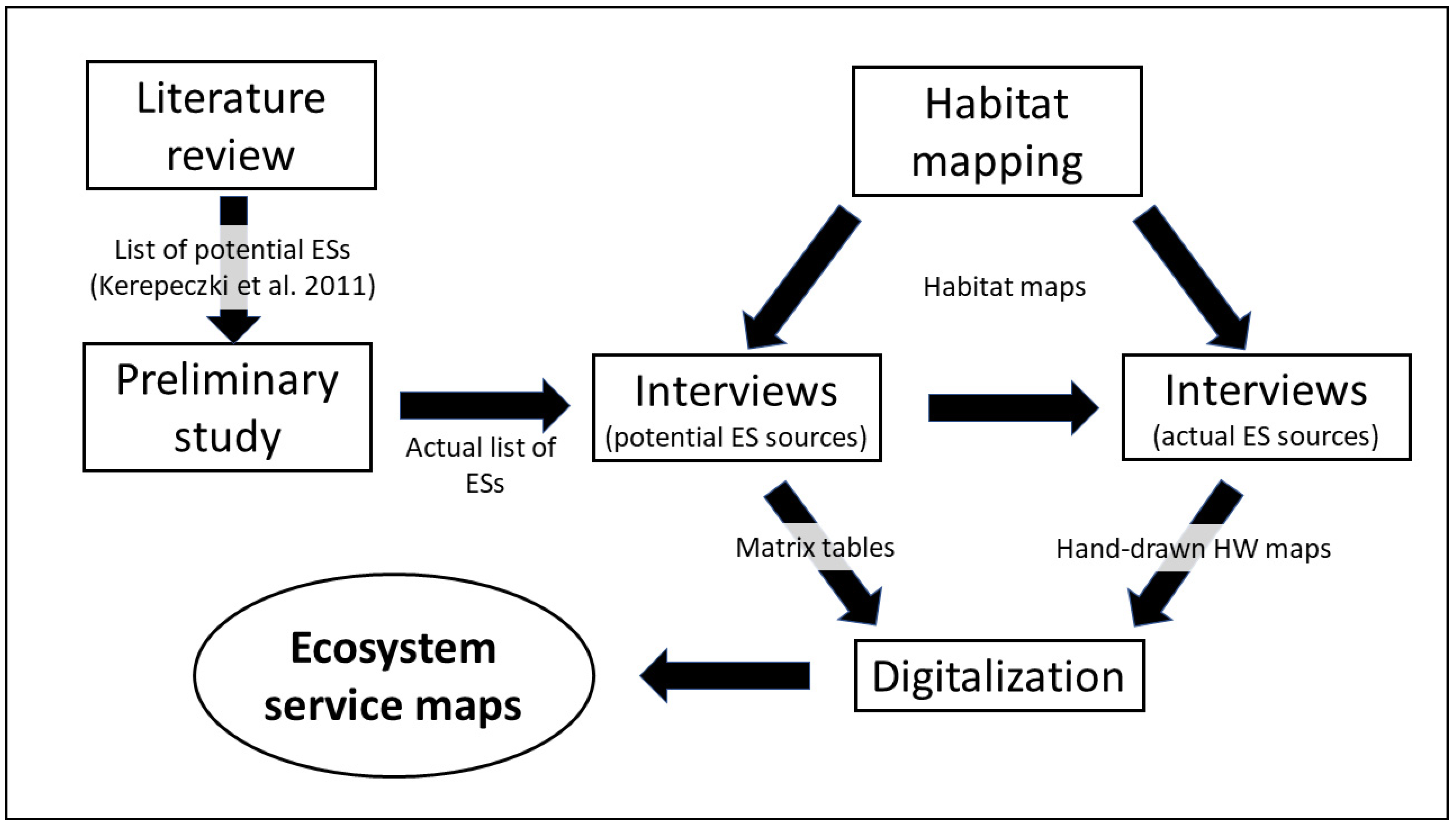
3. Methods
3.1. Habitat Mapping
3.2. Assessing White Lake’s Potential Service Providing Capabilities
3.3. Assessing White Lake’s Actual Service Providing Capabilities
4. Results
4.1. List of Ecosystem Services
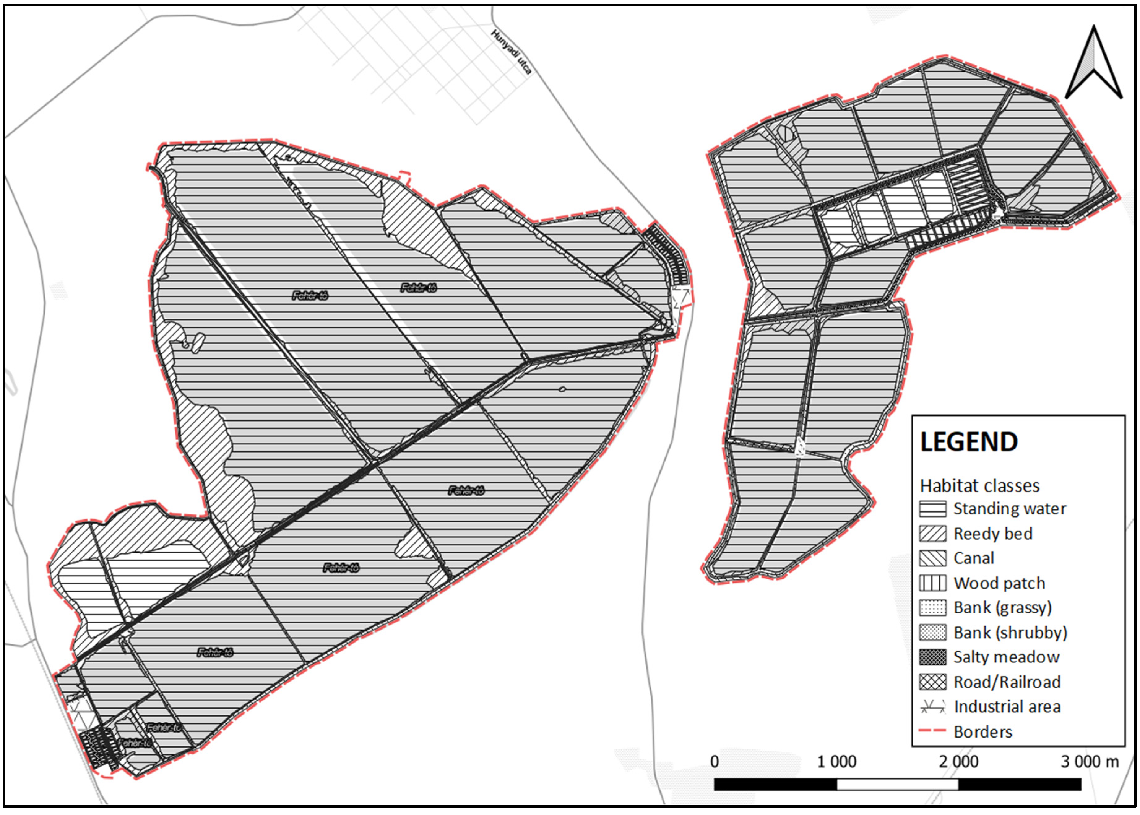
4.2. Habitat Classes
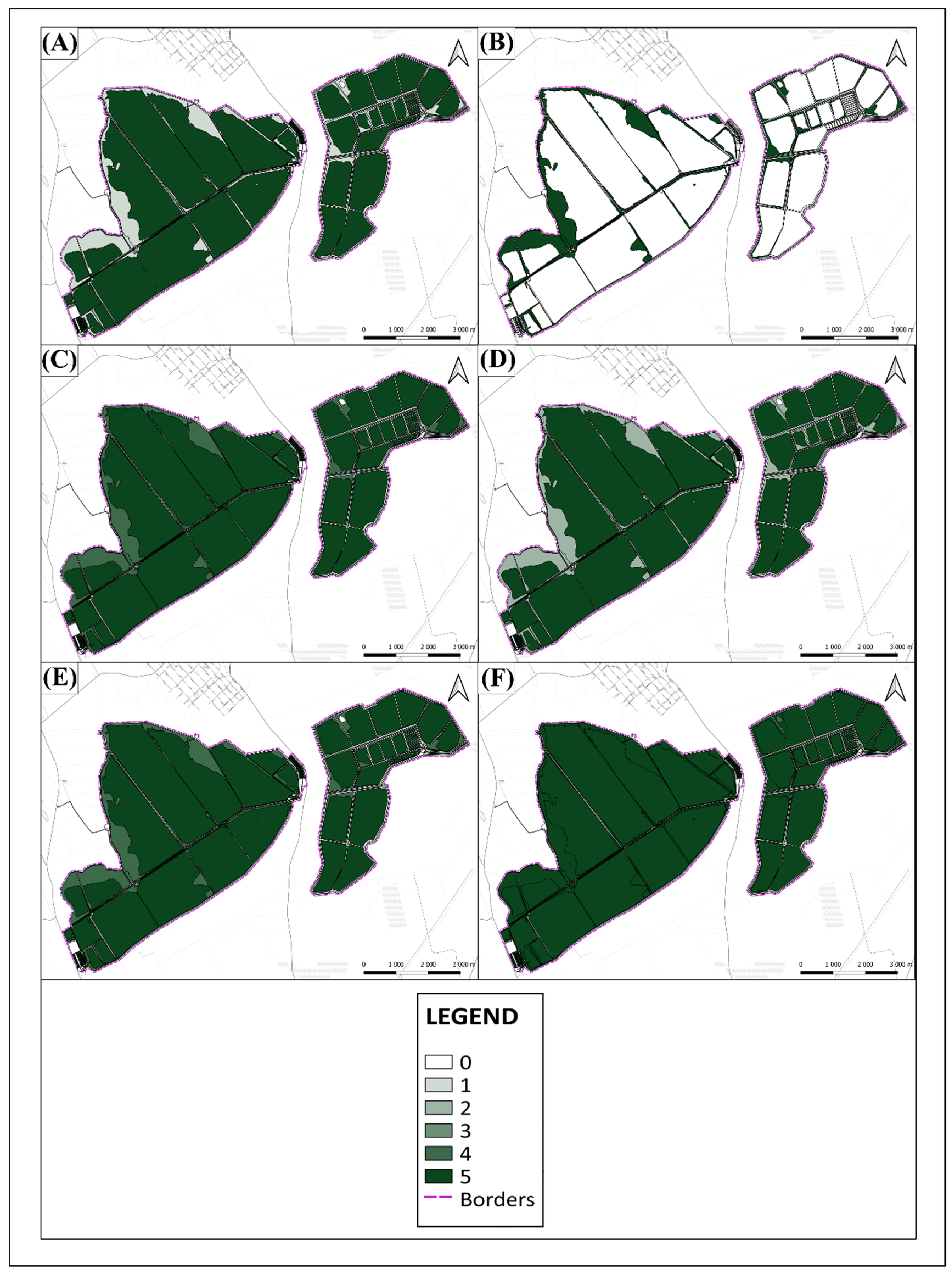
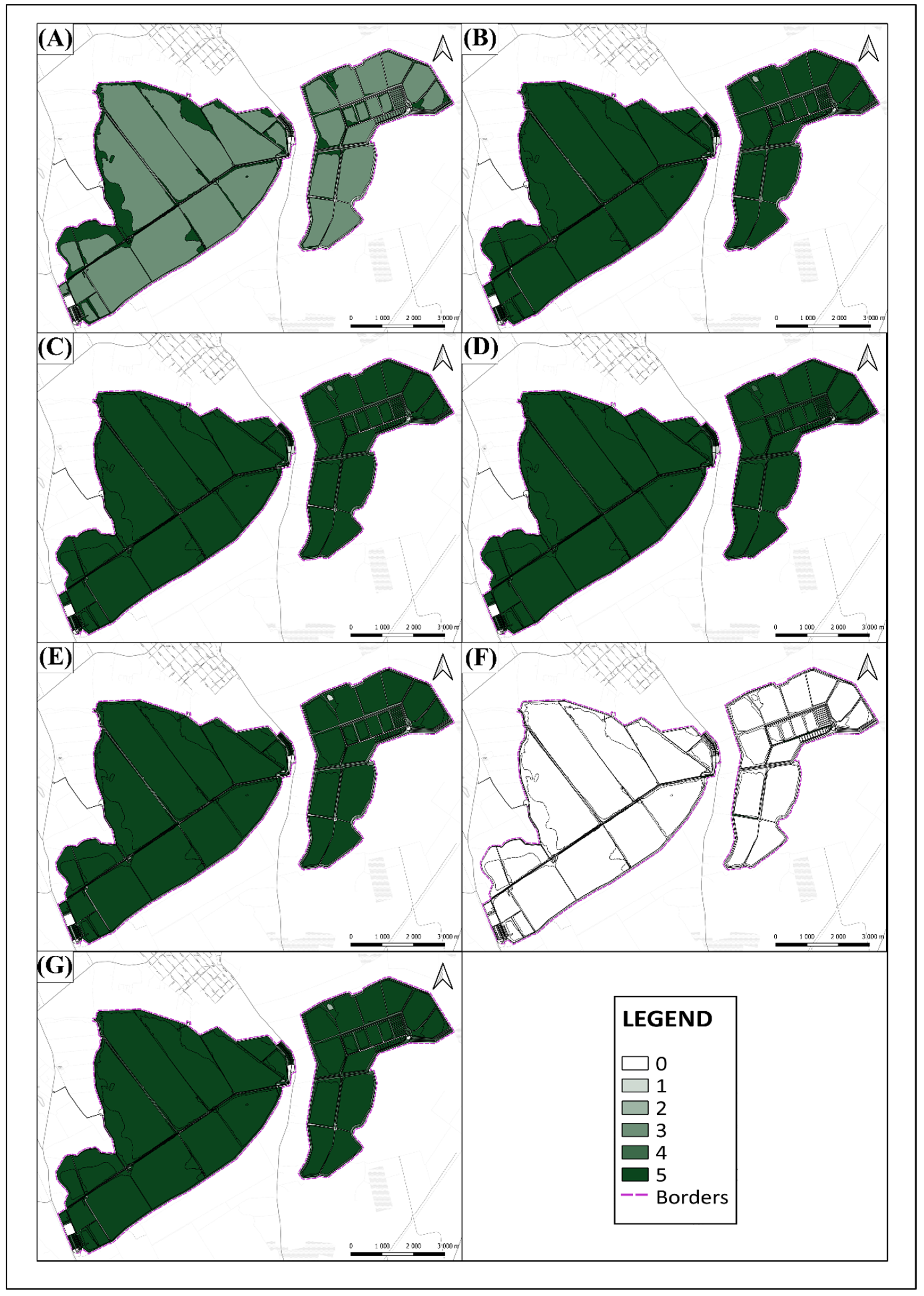
4.3. Results of Matrix Mapping
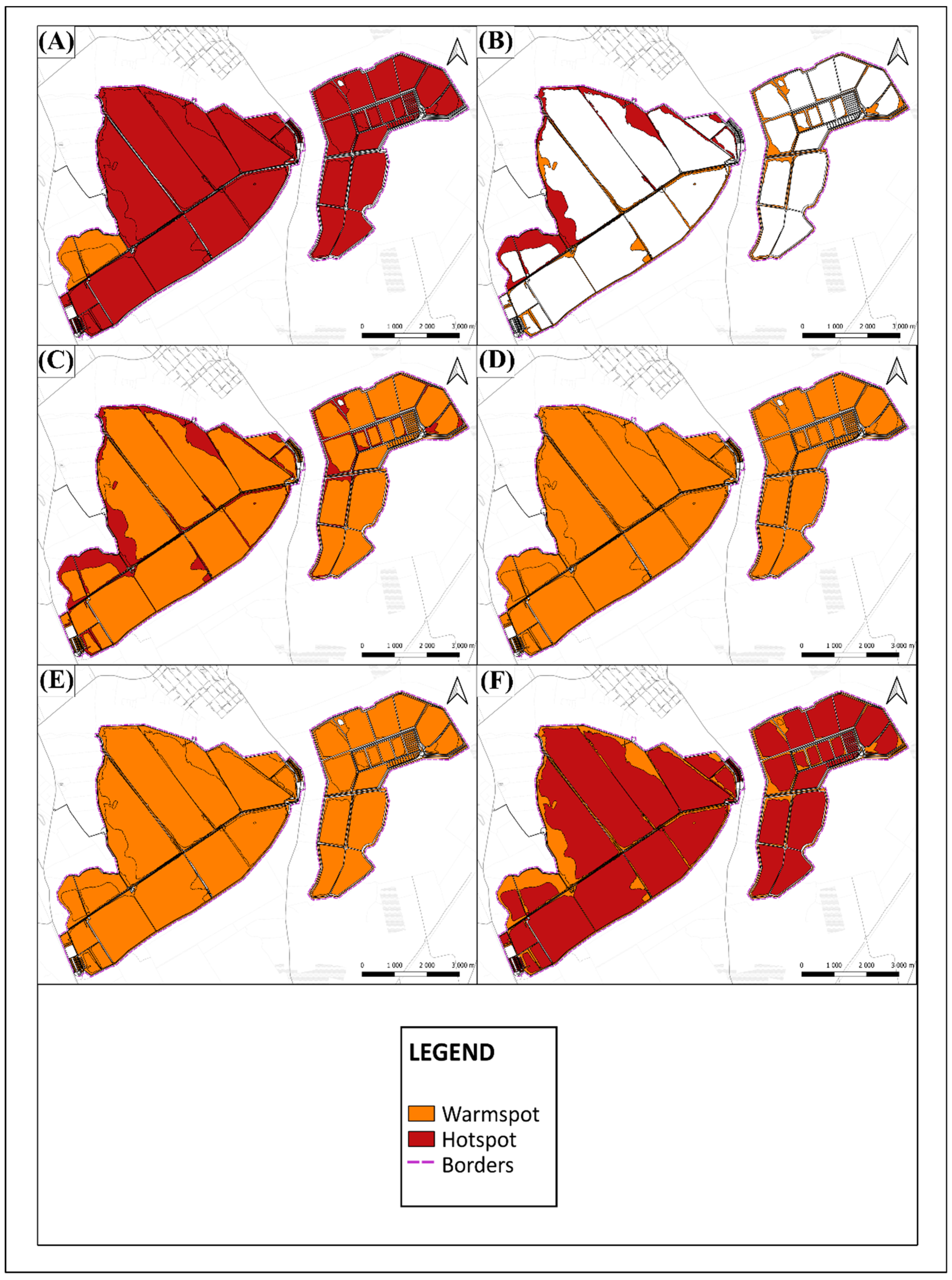
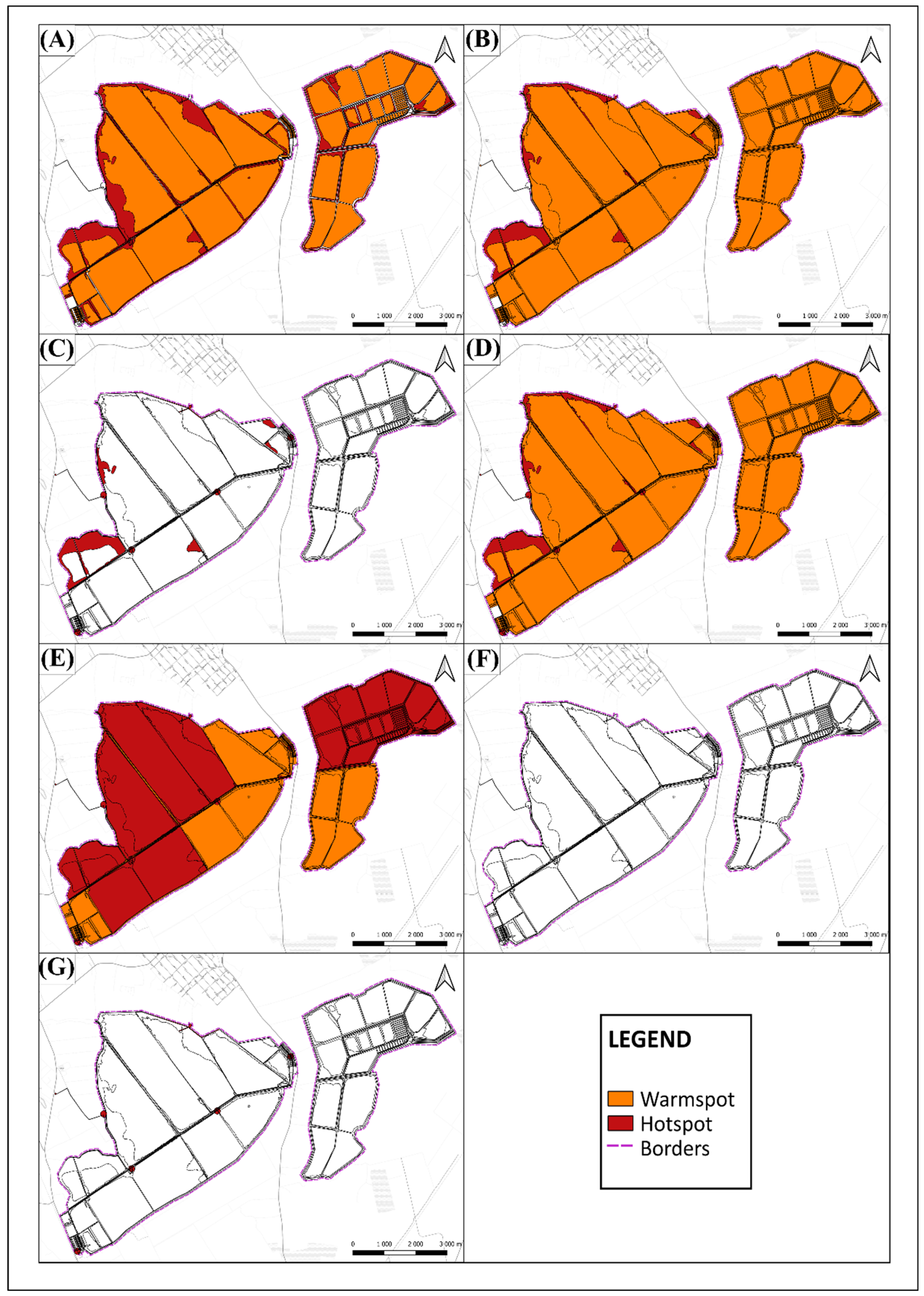
4.4. Results of Hotspot-Warmspot Mapping
5. Discussion
6. Conclusions
Author Contributions
Funding
Institutional Review Board Statement
Informed Consent Statement
Data Availability Statement
Acknowledgments
Conflicts of Interest
Appendix A

| Ecosystem Services | Descriptions |
|---|---|
| Fish production | food fish produced by the fish farm |
| Reed production | reed (as raw material), harvested from the area of the fishpond systems |
| Water quality regulation | ability of the fishpond systems to regulate the level of organic and inorganic materials in the water |
| Water storage | stored water of the fishpond system in case of extreme droughts |
| Water retention | ability of the fishpond systems to store the water of surface runoffs in case of extreme precipitation levels |
| Microclimate regulation | ability of the fishpond systems to puffer the local effects of extreme temperature fluctuations |
| Carbon sequestration and storage | ability of the fishpond systems’ vegetation to absorb and store CO2 from the air as carbon |
| Opportunities for scientific research | the possibility to implement scientific researches in the area of the fishpond system |
| Environmental education | opportunities provided for educational activities linked to the environment |
| Inspiration | ability of the fishpond systems to raise the level of cultural heritage and awareness |
| Bird watching | opportunities for watching the pond system’s avian fauna as a recreational activity |
| Recreational railroad traveling | opportunities for using fishpond system’s railroad system for sightseeing |
| Other recreational activities | different other forms of recreational activities provided by the fishpond system (hiking, hunting, etc.) |
| Á-NÉR Habitat Types | Main Habitat Classes | Area (Hectar) |
|---|---|---|
| U9—Standing waters | Periodic standing water | ~1736 |
| B1a—Eu- and mesotrophic reed and Typha beds | Reedy areas | ~280 |
| OG—Trampled and ruderal vegetation | Grass-dominated banks | ~64.6 |
| OA—Uncharacteristic wetlands | ||
| BA—Fine scale mosaic or zonation of marsh comunities | Canals | ~62.8 |
| OG—Trampled and ruderal vegetation | Shrub-dominated banks | ~22 |
| OA—Uncharacteristic wetlands | ||
| P2b—Dry and semi-dry pioneer scrub | ||
| RA—Scattered native threes and narrow three lines | ||
| S6—Spontaneous stands of non-native tree species | ||
| S7—Scattered trees or narrow tree lines of non-natives tree species | ||
| OG—Trampled and ruderal vegetation | Salty meadows | ~20 |
| F4—Dense and tall Puccinellia swards | ||
| F5—Annual salt pioneer swards of steppes and lakes | ||
| U11—Roads and railroads | Roads/railroad | ~11 |
| RA—Scattered native threes and narrow three lines | Woody patches | ~6 |
| RB—Uncharacteristic or pioneer softwood forests | ||
| U4—Yards, wastelands, dumping grounds | Industrial area | ~5.3 |
| Fish Production | Reed Production | Water Quality Regulation | Water Storage | Water Retention | Microclimate Regulation | Carbon Sequestration | Opportunities for Sci. Res. | Environmental Education | Inspiration | Bird Watching | Recr. Railroad Traveling | Other Rec. Activities | SUM | |
|---|---|---|---|---|---|---|---|---|---|---|---|---|---|---|
| Periodic standing waters | 5 | 0 | 5 | 5 | 5 | 5 | 3 | 5 | 5 | 5 | 5 | 0 | 5 | 53 |
| Reedy areas | 1 | 5 | 4 | 1 | 1 | 5 | 5 | 5 | 5 | 5 | 5 | 0 | 5 | 47 |
| Canals | 2 | 2 | 3 | 2 | 2 | 2 | 2 | 3 | 4 | 4 | 3 | 0 | 4 | 33 |
| Woody patches | 0 | 0 | 0 | 0 | 0 | 4 | 5 | 2 | 3 | 4 | 1 | 0 | 2 | 21 |
| Roads | 0 | 0 | 0 | 0 | 0 | 0 | 0 | 0 | 3 | 2 | 4 | 5 | 4 | 18 |
| Salty meadows | 0 | 0 | 0 | 0 | 0 | 1 | 1 | 3 | 3 | 4 | 2 | 0 | 4 | 18 |
| Bank (grassy) | 0 | 0 | 0 | 0 | 0 | 1 | 1 | 2 | 3 | 4 | 2 | 0 | 3 | 16 |
| Bank (shrubby) | 0 | 0 | 0 | 0 | 0 | 2 | 2 | 2 | 3 | 4 | 1 | 0 | 2 | 16 |
| Industrial area | 0 | 0 | 0 | 0 | 0 | 0 | 0 | 1 | 1 | 1 | 0 | 0 | 0 | 3 |
| Ecosystem Services | Hotspot Area (ha) | Warmspot Area (ha) | SUM (ha) |
|---|---|---|---|
| Bird watching | ~1471.3 | ~743.4 | ~2214.7 |
| Inspiration | ~108.5 | ~2101.7 | ~2210.2 |
| Opp. for scientific research | ~92.5 | ~2115.3 | ~2207.8 |
| Microclimate regulation | ~1736.4 | ~348.8 | ~2085.2 |
| Carbon sequestration and storage | ~348.8 | ~1736.4 | ~2085.2 |
| Water quality regulation | ~272.4 | ~1806.9 | ~2079.3 |
| Water storage | 0 | ~2072 | ~2072 |
| Water retention | 0 | ~2072 | ~2072 |
| Fish production | ~1916.9 | ~99.2 | ~2016.1 |
| Reed production | ~160.8 | ~181.9 | ~342.7 |
| Environmental education | ~82 | ~3.9 | ~85.9 |
| Other recreational activities | ~12.8 | 0 | ~12.8 |
| Recreational railroad traveling | ~4.2 | 0 | ~4.2 |
References
- FAO. The State of World Fisheries and Aquaculture 2020. Sustainability in Action; Food and Agriculture Organization (FAO): Rome, Italy, 2020; 244p. [Google Scholar] [CrossRef]
- Bahri, T.; Barange, M.; Moustahfid, H. Climate change and aquatic systems. In Impacts of Climate Change on Fisheries and Aquaculture: Synthesis of Current Knowledge, Adaptation and Mitigation Options. Fisheries and Aquaculture Technical Paper No. 627; Barange, M., Bahri, T., Beveridge, M.C.M., Cochrane, K.L., Funge-Smith, S., Poulain, F., Eds.; Food and Agriculture Organization (FAO): Rome, Italy, 2018; pp. 1–17. [Google Scholar]
- Cheung, W.W.L.; Sarmiento, J.L.; Dunne, J.; Frölicher, T.L.; Lam, V.W.Y.; Deng Palomares, M.L.; Watson, R.; Pauly, D. Shrinking of fishes exacerbates impacts of global ocean changes on marine ecosystems. Nat. Clim. Chang. 2013, 3, 254–258. [Google Scholar] [CrossRef]
- Blanchard, J.; Jennings, S.; Holmes, R.; Harle, J.; Merino, G.; Allen, I.; Holt, J.; Dulvy, N.; Barange, M. Potential consequences of climate change on primary production and fish production in large marine ecosystems. Philos. Trans. R. Soc. B 2012, 367, 2979–2989. [Google Scholar] [CrossRef] [PubMed]
- Merino, G.; Barange, M.; Blanchard, J.L.; Harle, J.; Holmes, R.; Allen, I.; Allison, E.H.; Badcheck, M.C.; Dulvy, N.K.; Holt, J.; et al. Can marine fisheries and aquaculture meet fish demand from a growing human population in a changing climate? Glob. Environ. Chang. 2012, 22, 795–806. [Google Scholar] [CrossRef]
- Lotze, H.K.; Tittensor, D.P.; Bryndum-Buchholz, A.; Eddy, T.D.; Cheung, W.W.L.; Galbraith, E.D.; Barange, M.; Barrier, N.; Bianchi, D.; Blanchard, J.L.; et al. Global ensemble projections reveal trophic amplification of ocean biomass declines with climate change. Proc. Natl. Acad. Sci. USA 2019, 116, 12907–12912. [Google Scholar] [CrossRef]
- Porter, J.R.; Xie, L.; Challinor, A.J.; Cochrane, K.; Howden, S.M.; Iqbal, M.M.; Lobell, D.B.; Travasso, M.I. Food security and food production systems. In Climate Change 2014: Impacts, Adaptation, and Vulnerability. Part A: Global and Sectoral Aspects. Contribution of Working Group II to the Fifth Assessment Report of the Intergovernmental Panel on Climate Change; Field, C.B., Barros, V.R., Dokken, D.J., Mach, K.J., Mastrandrea, M.D., Bilir, T.E., Chatterjee, M., Ebi, K.L., Estrada, Y.O., Genova, R.C., et al., Eds.; Cambridge University Press: Cambridge, UK, 2014; pp. 485–533. [Google Scholar]
- Dabbadie, L.; Aguilar-Manjarrez, J.; Beveridge, M.C.M.; Bueno, P.B.; Ross, L.G.; Soto, D. Effects of climate change on aquaculture: Drivers, impacts and policies. In Impacts of Climate Change on Fisheries and Aquaculture: Synthesis of Current Knowledge, Adaptation and Mitigation Options. Fisheries and Aquaculture Technical Paper No. 627; Barange, M., Bahri, T., Beveridge, M.C.M., Cochrane, K.L., Funge-Smith, S., Poulain, F., Eds.; Food and Agriculture Organization (FAO): Rome, Italy, 2018; pp. 449–463. [Google Scholar]
- Ionescu, D.T.; Hodor, C.V.; Petritan, I.C. Artificial Wetlands as Breeding Habitats for Colonial Waterbirds within Central Romania. Diversity 2020, 12, 371. [Google Scholar] [CrossRef]
- Kókai, K.; Mészáros, C. A Szegedi Fehér-tó és Fertő halastavaink vízi- és ragadozómadarai 1996–2005 között. Puszta 2009, 23, 91–106. [Google Scholar]
- De Silva, S.S.; Soto, D. Climate change and aquaculture: Potential impacts, adaptation and mitigation. In Climate Change Implications for Fisheries and Aquaculture: Overview of Current Scientific Knowledge. Fisheries and Aquaculture Technical Paper. No. 1530; Cochrane, K., De Young, C., Soto, D., Bahri, T., Eds.; Food and Agriculture Organization (FAO): Rome, Italy, 2009; pp. 151–212. [Google Scholar]
- Junk, W.J.; An, S.; Finlayson, M.; Gopal, B.; Květ, J.; Mitchell, S.A.; Mitsch, W.J.; Robarts, R.D. Current state of knowledge regarding the world’s wetlands and their future under global climate change: A synthesis. Aqua. Sci. 2012, 75, 151–167. [Google Scholar] [CrossRef]
- Hunter, M.L. A Mesofilter Conservation Strategy to Complement Fine and Coarse Filters. Conserv. Biol. 2005, 19, 1025–1029. [Google Scholar] [CrossRef]
- Hill, M.J.; Hassall, C.; Oertli, B.; Fahrig, L.; Robson, B.; Biggs, J.; Samways, M.; Usio, N.; Takamura, N.; Krishnaswamy, J.; et al. New policy directions for global pond conservation. Conserv. Lett. 2018, 11, e12447. [Google Scholar] [CrossRef]
- Huang, J.; Zhang, Y.; Arhonditsis, G.; Gao, J.; Chen, Q.; Wu, N.; Dong, F.; Shi, W. How successful are the restoration efforts of China’s lakes and reservoirs? Environ. Int. 2019, 123, 96–103. [Google Scholar] [CrossRef]
- European Commission. Mapping and Assessment of Ecosystems and Their Services, An Analytical Framework for Ecosystem Assessments under Action 5 of the EU Biodiversity Strategy to 2020; Discussion Paper; Publications Office of the European Union: Luxembourg, 2012; 78p. [Google Scholar]
- Walton, M.E.M.; Vilas, C.; Cañavate, J.P.; Gonzalez-Ortegon, E.; Prieto, A.; Van Bergeijk, S.A.; Green, A.J.; Librero, M.; Mazuelos, N.; Le Vay, L. A model for the future: Ecosystem services provided by the aquaculture activities of Veta la Palma, Southern Spain. Aquaculture 2015, 448, 382–390. [Google Scholar] [CrossRef]
- Naylor, R.L.; Goldburg, R.J.; Primavera, J.H.; Kautsky, N.; Beveridge, M.C.M.; Clay, J.; Folke, C.; Lubchenco, J.; Mooney, H.; Troell, M. Effect of aquaculture on world fish supplies. Nature 2000, 405, 1017–1024. [Google Scholar] [CrossRef] [PubMed]
- MEA. Ecosystems and Human Well-Being: Synthesis; Island Press: Washington, DC, USA, 2005; 155p. [Google Scholar]
- Haines-Young, R.; Potschin, M.B. Common International Classification of Ecosystem Services (CICES) V5.1 and Guidance on the Application of the Revised Structure; Fabis Consulting Ltd.: Nottingham, UK, 2018; 53p. [Google Scholar]
- Willot, P.A.; Aubin, J.; Salles, J.M.; Wilfart, A. Ecosystem service framework and typology for an ecosystem approach to aquaculture. Aquaculture 2019, 512, 734260. [Google Scholar] [CrossRef]
- Weitzman, J. Applying the ecosystem services concept to aquaculture: A review of approaches, definitions, and uses. Ecos. Serv. 2019, 35, 194–206. [Google Scholar] [CrossRef]
- Tress, B.; Tress, G.; Fry, G. Defining concepts and the process of knowledge production in integrative research. In From Landscape Research to Landscape Planning: Aspects of Integration, Education and Application; Tress, B., Tress, G., Fry, G., Opdam, P., Eds.; Springer: Dordrecht, The Netherlands, 2005; pp. 13–26. [Google Scholar]
- Affek, A.; Aranyi, I.; Černecký, J.; Ďuricová, V.; Favilli, F.; Lehejček, J.; Mederly, P.; Švajda, J. The Carpathian Ecosystem Services Toolkit. Interreg CENTRAL EUROPE Project Centralparks “Building Management Capacities of Carpathian Protected Areas for the Integration and Harmonization of Biodiversity Protection and Local Socio-Economic Development”, Deliverable D.T3.1.3; State Nature Conservancy of the Slovak Republic: Banská, Bystrica, 2021; 42p. [Google Scholar]
- Brown, G.; Fagerholm, N. Empirical PPGIS/PGIS mapping of ecosystem services: A review and evaluation. Ecos. Serv. 2015, 13, 119–133. [Google Scholar] [CrossRef]
- Somogyi, S. A XIX. Századi Folyószabályozások és Ármentesítések Földrajzi és Ökológiai Hatásai Magyarországon; MTA Földrajztudományi Kutatóintézet: Budapest, Hungary, 2000; 299p. [Google Scholar]
- Oláh, J.; Pekár, F.; Váradi, L. Extenzív Halastavi Gazdálkodás és Ökoturisztikai Fejlesztés, Biharugrai-Halastavak Esettanulmány; BirdLife Hungary: Biharugra-Budapest, Hungary, 2009; 27p. [Google Scholar]
- Sztanó, J. A Fehértó Halgazdálkodása (Dorozsmai Füzetek 20.); SzegedFish Ltd.: Szeged, Hungary, 2018; 28p. [Google Scholar]
- Edwards, P.; Pullin, R.S.V.; Gartner, J.A. Research and Education for the Development of Integrated Crop-Livestock-Fishfarming Systems in the Tropics. ICLARM Studies and Reviews 16; ICLARM: Manila, Philippines, 1988; 53p. [Google Scholar]
- Edwards, P. Environmental issues in integrated agriculture-aquaculture and wastewater-fed fish culture systems. In Environment and Aquaculture in Developing Countries. ICLARM Conference Proceedings 31; Pullin, R.S.V., Rosenthal, H., Maclean, J.L., Eds.; ICLARM: Manila, Philippines, 1993; pp. 139–170. [Google Scholar]
- Horváth, L.; Tamás, G.; Seagrave, C. Carp and Pond Fish Culture, 2nd ed.; Blackwell Science Ltd.: Oxford, UK, 2002; 170p. [Google Scholar]
- A Szegedi Fehér-Tón Előfordult Madárfajok Listája. Available online: http://www.fotringing.hu/oldal/fotmadarai.aspx (accessed on 23 September 2022).
- Keveiné Bárány, I.; Mucsi, L.; Tímár, B. A szegedi Fehértó állapotváltozásai. In Az Alföld Történeti Földrajza; MTA Szabolcs-Szatmár-Bereg Megyei Tudományos Testület, Nyíregyházi Főiskola Földrajz Tanszéke: Nyíregyháza, Hungary, 2000; pp. 53–66. [Google Scholar]
- Palásti, P.; Kiss, M.; Gulyás, Á.; Kerepeczki, É. Expert Knowledge and Perceptions about the Ecosystem Services and Natural Values of Hungarian Fishpond Systems. Water 2020, 12, 2144. [Google Scholar] [CrossRef]
- Newing, H.; Eagle, C.M.; Puri, R.K.; Watson, C.W. Conducting Research in Conservation. Social Science Methods and Practice; Routledge Taylor Francis Group: London, UK, 2011; 400p. [Google Scholar]
- Schutt, R.K. Investigating the Social World: The Process and Practice of Research, 6th ed.; Pine Forge Press: Los Angeles, CA, USA, 2009; 564p. [Google Scholar]
- Kerepeczki, É.; Gyalog, G.; Halasi-Kovács, B.; Gál, D.; Pekár, F. Ecological values and functions of extensive fishponds. In Halászatfejlesztés; Kerepeczki, É., Bozánné Békefi, E., Gyalog, G., Lehoczky, I., Eds.; National Agricultural Research and Innovation Center—Research Institute for Fisheries and Aquaculture: Szarvas, Hungary, 2011; Volume 33, pp. 47–54. [Google Scholar]
- Blayac, T.; Mathé, S.; Rey-Valette, H.; Fontaine, P. Perceptions of the services provided by pond fish farming in Lorraine (France). Ecol. Econ. 2014, 108, 115–123. [Google Scholar] [CrossRef]
- Bölöni, J.; Molnár, Z.; Kun, A. Magyarország Élőhelyei. A Hazai Vegetációtípusok Leírása és Határozója; MTA Ökológiai és Botanikai Kutatóintézet: Vácrátót, Hungary, 2011; 439p. [Google Scholar]
- Tanács, E.; Belényesi, M.; Lehoczki, R.; Pataki, R.; Petrik, O.; Standovár, R.; Pásztor, L.; Laborczi, A.; Szatmári, G.; Molnár, Z.; et al. Compiling a high-resolution country-level ecosystem map to support environmental policy: Methodological challenges and solutions from Hungary. Geocarto Int. 2021, 36, 1–24. [Google Scholar] [CrossRef]
- Kelemen, E.; Pataki, G. Az ökoszisztéma-szolgáltatások értékelésének elméleti megalapozása. In Ökoszisztéma-Szolgáltatások: A Természet-és Társadalomtudományok Metszéspontjában; Kelemen, E., Pataki, G., Eds.; SZIE Környezet és Tájgazdálkodási Intézet: Gödöllő, Hungary, 2014; pp. 37–57. [Google Scholar]
- Burkhard, B.; Kroll, F.; Müller, F.; Windhorst, W. Landscapes’ Capacities to Provide Ecosystem Services-A concept for Land-Cover Based Assessments. Landsc. Online 2009, 15, 1–22. [Google Scholar] [CrossRef]
- Jacobs, S.; Burkhard, B.; Van Daele, T.; Staes, J.; Schneiders, A. ‘The Matrix Reloaded’: A review of expert knowledge use for mapping ecosystem services. Ecol. Model. 2015, 295, 21–30. [Google Scholar] [CrossRef]
- Marjainé Szerényi, Z.; Kovács, E.; Kalóczkai, Á.; Zölei, A. Az Ökoszisztéma Szolgáltatások Társadalmi-Gazdasági Értékelési “Módszertani Menü" Összeállítása. KEHOP-4.3.0-15-2016-00001: A Közösségi Jelentőségű Természeti Értékek Hosszú Távú Megőrzését és Fejlesztését, Valamint az EU Biológiai Sokféleség Stratégia 2020 Célkitűzéseinek Hazai Megvalósítását Megalapozó Stratégiai Vizsgálatok. Nemzeti Ökoszisztéma Szolgáltatások Térképezése és Értékelése Projektelem (NÖSZTÉP) II/2E. 2.4.3; Agrárminisztérium: Budapest, Hungary, 2018; 39p, Available online: http://www.termeszetvedelem.hu/_user/browser/File/KEHOP/NOSZTEP/12_%20Az%20%c4%82%c2%b6koszizst%c4%82%c2%a9ma-szolg%c4%82%cb%87ltat%c4%82%cb%87sok%20t%c4%82%cb%87rsadalmi-gazdas%c4%82%cb%87gi%20%c4%82%c2%a9rt%c4%82%c2%a9kel%c4%82%c2%a9si%20m%c4%82%c5%82dszertani%20men%c4%82%c4%bdje.pdf (accessed on 23 September 2022).
- Burkhard, B.; Maes, J. Mapping Ecosystem Services; Pensoft Publishers: Sofia, Bulgaria, 2017; 373p. [Google Scholar]
- Palomo, I.; Martín-López, B.; Potschin, M.; Haines-Young, R.; Montes, C. National Parks, buffer zones and surrounding lands: Mapping ecosystem service flows. Ecos. Serv. 2013, 4, 104–116. [Google Scholar] [CrossRef]
- Alessa, N.L.; Kliskey, A.A.; Brown, G. Social-ecological hotspots mapping: A spatial approach for identifying coupled social-ecological space. Landsc. Urban Plan. 2008, 85, 27–39. [Google Scholar] [CrossRef]
- Lechner, A.M.; Raymond, C.M.; Adams, V.M.; Polyakov, M.; Gordon, A.; Rhodes, J.R.; Mills, M.; Stein, A.; Ives, C.D.; Lefroy, E.C. Characterizing spatial uncertainty when integrating social data in conservation planning. Conserv. Biol. 2014, 28, 1497–1511. [Google Scholar] [CrossRef] [PubMed]
- Klain, S.C.; Chan, K.M.A. Navigating coastal values: Participatory mapping of ecosystem services for spatial planning. Ecol. Econ. 2012, 82, 104–113. [Google Scholar] [CrossRef]
- Palomo, I.; Martín-López, B.; Zorrilla-Miras, P.; Del Amo, D.G.; Montes, C. Deliberative mapping of ecosystem services within and around Doñana National Park (SW Spain) in relation to land use change. Reg. Environ. Chang. 2014, 14, 237–251. [Google Scholar] [CrossRef]
- Raymond, C.M.; Bryan, B.A.; MacDonald, D.H.; Cast, A.; Strathearn, S.; Grandgirard, A.; Kalivas, T. Mapping community values for natural capital and ecosystem services. Ecol. Econ. 2009, 68, 1301–1315. [Google Scholar] [CrossRef]
- De Vreese, R.; Leys, M.; Fontaine, C.M.; Dendoncker, N. Social mapping of perceived ecosystem services supply–The role of social landscape metrics and social hotspots for integrated ecosystem services assessment, landscape planning and management. Ecol. Indic. 2016, 66, 517–533. [Google Scholar] [CrossRef]
- Crossman, N.D.; Burkhard, B.; Nedkov, S.; Willemen, L.; Petz, K.; Palomo, I.; Drakou, E.G.; Martín-López, B.; Mcphearson, T.; Boyanova, K.; et al. A blueprint for mapping and modelling ecosystem services. Ecosyst. Serv. 2013, 4, 4–14. [Google Scholar] [CrossRef]
- Custódio, M.; Villasante, S.; Calado, R.; Lillebø, A. Valuation of Ecosystem Services to promote sustainable aquaculture practices. Rev. Aquacult. 2019, 12, 392–405. [Google Scholar] [CrossRef]
- Turkowski, K.; Lirski, A. Non-productive functions of fish ponds and their possible economic evaluation. In Carp Culture in Europe. Current Status, Problems, Perspectives, Proceedings of International Carp Conference, Olsztyn, Poland, 15–16 September 2011; Lirski, A., Pyć, A., Eds.; Instytut Rybactwa Śródlądowego (IRŚ): Olsztyn, Poland, 2011; pp. 25–42. [Google Scholar]
- Yang, W.; Chang, S.X.; Xu, B.; Peng, C.; Ge, Y. Ecosystem service value assessment for constructed wetlands: A case study in Hangzhou, China. Ecol. Econ. 2008, 68, 116–125. [Google Scholar] [CrossRef]


Publisher’s Note: MDPI stays neutral with regard to jurisdictional claims in published maps and institutional affiliations. |
© 2022 by the authors. Licensee MDPI, Basel, Switzerland. This article is an open access article distributed under the terms and conditions of the Creative Commons Attribution (CC BY) license (https://creativecommons.org/licenses/by/4.0/).
Share and Cite
Palásti, P.; Gulyás, Á.; Kiss, M. Mapping Freshwater Aquaculture’s Diverse Ecosystem Services with Participatory Techniques: A Case Study from White Lake, Hungary. Sustainability 2022, 14, 16825. https://doi.org/10.3390/su142416825
Palásti P, Gulyás Á, Kiss M. Mapping Freshwater Aquaculture’s Diverse Ecosystem Services with Participatory Techniques: A Case Study from White Lake, Hungary. Sustainability. 2022; 14(24):16825. https://doi.org/10.3390/su142416825
Chicago/Turabian StylePalásti, Péter, Ágnes Gulyás, and Márton Kiss. 2022. "Mapping Freshwater Aquaculture’s Diverse Ecosystem Services with Participatory Techniques: A Case Study from White Lake, Hungary" Sustainability 14, no. 24: 16825. https://doi.org/10.3390/su142416825
APA StylePalásti, P., Gulyás, Á., & Kiss, M. (2022). Mapping Freshwater Aquaculture’s Diverse Ecosystem Services with Participatory Techniques: A Case Study from White Lake, Hungary. Sustainability, 14(24), 16825. https://doi.org/10.3390/su142416825