Abstract
Urbanization can increase artificial coverage rates and emissions by causing increases in traffic, which represents a serious health risk to pedestrians. To create pedestrian-friendly environments in urban canyons, this study examined their microclimates and air quality; methods to improve the pedestrian environment were also explored, based on the current street green space practices in Seoul, Korea. Under these current standards, the physiologically equivalent temperature (PET) of the pedestrian roads was predicted to decrease by 1.29–1.44 °C, but this was insufficient to adjust the thermal stress level. The air temperature of the pedestrian road declined slightly; fine dust concentrations increased, and ozone concentrations decreased. The effects of increasing the planting occupancy on the pedestrian environment were then simulated, which resulted in decreases in PET of 3.04–3.49 °C, depending on the floor area ratio, thereby effectively lowering the thermal stress stage. The particulate matter concentrations increased, however, and the air quality deteriorated. Therefore, street greenery planning alone cannot sufficiently improve both the microclimate and air quality of urban pedestrian roads. Thus, it is necessary to plan street greenery spaces in parallel with measures to improve air quality.
1. Introduction
1.1. Background and Necessity of Research
More than half of the world’s population lives in urban areas; they are especially concentrated in high-density cities. This proportion is expected to increase to 68% by 2050 [1]. Along with this increase in population, urbanization is also leading to increases in traffic volume and exhaust gas emissions. Air pollutants as a road-mobile pollution source cause the urban pollution island (UPI) phenomenon, in which areas with higher levels of pollution than the surrounding suburbs form in urban areas. UPIs form because the surrounding high-rise buildings restrict the dispersion of pollution. In addition, skyscrapers are concentrated around roads in urban street canyons, limiting the dispersion of vehicle emissions, which leads to the deterioration of roadside air quality. This poses a serious health risk to the public [2]. The change in land cover attributed to the increase in artificial cover resulting from high-density development in the urban space and the anthropogenic heat generated from energy use in buildings and exhaust gas from automobiles are factors that raise the temperature of urban spaces, causing the UHI.
This can significantly increase building energy consumption and aggravate thermal comfort, leading to increased heat-related mortality. UHIs and UPIs, which are both caused by urbanization, are closely related. Therefore, urban planning should aim to improve thermal comfort and air quality at the same time.
City streets are important public spaces for outdoor activities. Thus, air pollution in urban canyons negatively impacts the health of members of the public, including pedestrians, drivers, and residents within buildings. Pedestrians are easily exposed to the effects of air pollutants as a road-mobile pollution source emitted from vehicles that pass by them on roads. Road traffic releases a variety of hazardous pollutants, exposure to which is associated with increased risks of cardiovascular and lung diseases [3]. Green infrastructure improves the sustainability of cities by reducing air and noise pollution and providing better rainwater management [1]. Street trees provide various functions for citizens, such as controlling temperature, purifying air pollution, controlling noise, providing a disaster buffer effect, providing a biological habitat, and creating beautiful urban landscapes [4]. On the other hand, trees can slow airflow in urban canyons and affect the canyon vortex, which can have negative effects on ventilation and can significantly reduce local air quality. Further research is thus required to clearly understand such effects [5].
Herein, therefore, the effects of street greenery planning for urban roadsides on the pedestrian environment were investigated. Furthermore, methods to create a pleasant walking environment by improving the microclimate and air quality were explored.
1.2. Prior Research
Air pollution and UHIs that occur within urban canyons affect pedestrians, so it is necessary to develop comprehensive measures to improve them. Studies that have focused on creating a comfortable pedestrian space are reviewed in this section. A review has also been conducted into mechanisms to control the dispersion of vehicle emissions in urban canyons, as well as into strategies for managing roadside air pollution [2]. The effects of street trees on aerosol concentrations (PM10 and PM2.5) in a boulevard-type urban canyon with a high traffic volume have also been examined in Helsinki, using the large-eddy simulation model PALM [5]. Numerical experiments have also been performed on urban canyons with various aspect ratios (ARTs), leaf area index (LAI) values, leaf areal density (LAD) values, and wind conditions [6]. Three-dimensional (3D) computational fluid dynamics (CFD) have been used to investigate the possibility of manual controlling trees and cars parked along streets regarding pedestrian exposure to air pollutants in urban canyons [7]. Experiments and CFD-based simulations have also been conducted to understand the local scale flow and pollutant concentrations of an ideal urban canyon, accompanied by the simulation of actual city intersections [8]. The flow of urban canyons and the distribution of traffic exhaust gas have also been studied in relation to tree planting. Through tunnel experiments and CFD-based simulations, a method has also been developed to obtain quantitative information for the evaluation, planning, and implementation of exposure mitigation using trees in urban canyons [9]. A further paper has discussed the combined influences of building morphology and trees on air pollutant concentrations in Marylebone, central London [10]. We reviewed available studies on the effects of urban street canyons, open roads, and building envelope integrated green plants on air quality. Furthermore, factors affecting air quality (e.g., urban morphology, weather conditions, and vegetation characteristics) were analyzed and enumerated, and resulting favorable and critical air pollution scenarios were observed [11]. Laboratory experiments and computational fluid dynamics (CFDs) were used to investigate the aerodynamic effects of trees on local flows and pollutant concentrations in ideal urban street canyon configurations [8]. The aerodynamic effects of tree planting on the flow of urban canyons and the dispersion of traffic-causing pollutants were studied using wind tunnel tests and numerical simulations [12]. Wind-tunnel studies of the dispersion processes of traffic exhaust in urban street canyons with tree planting were performed, and tracer gas concentrations using electron capture detection (ECD) and flow fields using laser Doppler velocimetry (LDV) were measured [13].
Experiments and simulations have also been conducted to improve various problems that occur in urban canyons, suggesting that it is possible to improve their environments using street greenery. However, more research is needed to solve the problems of air pollution and UHIs occurring within urban canyons.
Therefore, this study primarily aimed to examine street greenery planning along urban roadsides, review the types of street greenery spaces that can improve thermal comfort and air quality, and identify the problems of current planning practices. Approaches that can improve both thermal comfort and air quality for pedestrians were also explored.
1.3. Purpose and Methodology of the Research
Unlike the surburbs, roadsides along urban canyons experience high volumes of vehicle traffic, which leads to higher emissions of automobile-related pollutants. In addition, changes in heat balance on the ground surface, increasing anthropogenic heat levels, and increased emissions of pollutants following an increase in impermeable land cover in urban areas have been damaging the health of pedestrians.
This study thus aimed to characterize the microclimates and dust hazes occurring in urban canyons and to explore ways to improve these environments. Based on the current status of street greenery spaces in Seoul, Korea, the impacts of street greenery spaces on pedestrian paths were analyzed, and street greenery planning was investigated as a method to ensure pleasant pedestrian paths. With regard to the research method used, we first selected an urban street canyon case study model based on the current status of the street greenery planning. In the second step, we applied 12% of the street greenery occupancy by type (i.e., planting, green belt, and grass) and then simulated 12%, 23%, and 45% of the street greenery occupancy by each type that affects the improvement of the pedestrian environment. ENVI-met simulations were generated to investigate changes in the air quality, including those of the microclimate and particulate matter in the pedestrian environment in urban street canyons. Furthermore, statistical analysis was carried out to examine the environmental impact of weather factors, as well as street greenery planning on pedestrian paths.
2. Simulation Overview
2.1. D microclimate Model
ENVI-met is a model that can calculate urban climate at spatial and temporal intervals of 0.5–10.0 m and 10 s, respectively, in a typical grid format. ENVI-met was based on the theory of CFD, to build plant–surface–atmosphere interactions concerning the outdoor environment by using different buildings, various pavement materials, and various vegetation in different configurations. It uses the Eulerian approach to study the dispersion of air pollutants, allowing the simulation of pollutant dispersion including aerosol particles, passive gases, and reactive gases. The Reynolds-averaged Navier–Stokes (RANS) standard k − ε model is used, and the dispersion of air pollutants is calculated using the standard advection–diffusion governing equation. In the model, each plant is treated as a one-dimensional, permeable column that is subdivided into layers. Above ground, each plant is described by a leaf area density (LAD) profile and under the soil surface by a root area density (RAD) profile. To account for vegetation’s influence on atmospheric processes, all prognostic equations in the model are extended into the vegetation layers using source/sink terms describing heat, humidity, and momentum exchanges. An integrated vegetation model helps to resolve source/sink terms, which are calculated using the LAD and wind, temperature, and humidity gradients [14]. ENVI-met calculates various meteorological parameters, such as air temperature (Ta), relative humidity, and wind speed (WS), as well as thermal comfort indices, such as mean radiant temperature (MRT) and predicted mean vote (PMV). Studies using ENVI-met can be divided into two categories: those investigating the effects of urban design on outdoor microclimates, namely, thermal environments [15,16,17,18] and air quality [18,19,20,21,22,23] and those comparing field experiences with simulation results, thereby evaluating the performance of ENVI-met by comparing simulation results with field experimental data. These studies have confirmed that ENVI-met can simulate both spatial and temporal temperature and WS variations with acceptable accuracy for assessing microclimates, in both simple and complex urban areas [14,19,23,24,25,26,27,28].
2.2. Simulation Conditions
Table 1 shows the simulation execution conditions. The simulation was conducted under heatwave conditions by selecting a period covering the record-high temperature in 2018 (the maximum temperature [39.4 °C] occurred on 1 August 2018). The meteorological data were obtained from the Automated Synoptic Observing System (ASOS). The total simulation time was set to 24 h.

Table 1.
Simulation execution conditions.
Table 2 presents the conditions used to establish data related to automobile traffic in the city in this study. The daily traffic volume was set based on the Seoul Traffic Survey Report, assuming that 25.0% of the paved roads in the city and province had four lanes. The Seoul Open Data Plaza was used to set the traffic volume by type and size. These data were applied to the simulation by calculating the emissions by vehicle type and the emissions per hour.
Table 2.
Distribution of traffic flow.
PM elements were modeled for the road, including PM2.5, PM10, O3, NO2, and NOx. Microclimate parameters including the atmospheric temperature of the pedestrian road (Ta), WS of the pedestrian road, and physiologically equivalent temperature (PET) were also modeled to consider human physiological parameters. Thermal comfort was evaluated with reference to EN-ISO 7730 and other studies [29]. The heat stress felt by humans is classified into 4 levels: weak heat stress (23–29 °C), moderate heat stress (29–35 °C), strong heat stress (35–41 °C), and extreme heat stress (>41 °C). The results included thermal comfort (PET) for outdoor spaces, which have been verified by a number of studies [30,31,32,33].
3. Case Study Overview
3.1. Conditions for Case Study
Modeling was carried out to examine changes in air pollution diffusion and ambient temperature, centered on the urban canyons with the largest floating populations and automobile traffic in the city [34,35].
Seoul, which has the highest population density and densest traffic and has high concentrations of artificial covering and artificial heat, was selected as the target. The study area was set as the central commercial area with the longest width ratio in the city (53.2%) [36]. Based on the Seoul Metropolitan City Urban Planning Ordinance (building-to-land ratio < 60%, floor area ratio < 1000%), it was assumed that the building-to-land ratio was <30% and that the floor area ratio was 500–700%.
Figure 1 shows an outline of the case study, which was divided into Stages 1 and 2. In Stage 1, microclimate, particulate matter, and thermal comfort (PET) were assessed over the most frequently used types of street greenery planning, including grass, green belts, and roadside green areas. Based on the current standards of Seoul, the green space types were set at intervals of 7–9 m and with heights of 5–10 m for street trees [37] and 1.0–1.5 m for shrubs [38]. In Stage 2, the effects of changing the urban canyon’s street environment on the pedestrian path were analyzed, and ways to change and improve the environment of the pedestrian passage were explored by increasing the occupancy rate of the most influential type of green space.
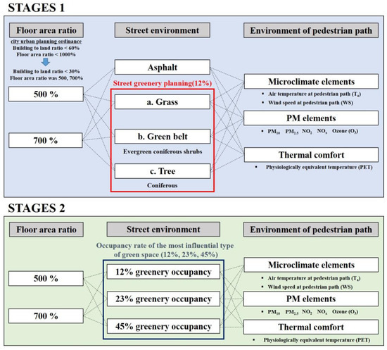
Figure 1.
Outline of the case study.
3.2. Case Study Model Overview
Although an actual location was not selected for the case study, Seoul (latitude 37°33′59″, longitude 126°58′41″) was selected as the study site, as it is the central area of economic activity and was thus suitable for the direction of this study. Figure 2 shows an overview of the simulation case model. The site area of the case study was 172.0 × 88.0 m, and the buildings were arranged in a straight line along the road. The size of each building was taken to be 20.0 × 20.0 m. The width of the sidewalk was set to 4.0 m, which accounted for 26% of the domestic pedestrian road width; the road was assumed to have four lanes (total width = 12.0 m) [37]. The volume of vehicle traffic reflected the traffic data for the respective branch in downtown Seoul. The ground surface of the target site was set as asphalt, and the building material was set as concrete. To analyze the results of street greenery planning for urban roadsides, a simulation was conducted with asphalt as a control group; grass, green belt, and tree were trialed as experimental groups. Table 3 outlines the types of roadside greenery in the experimental group (grass, green belt, and tree). The distances and heights of green spaces were established based on the current standards in Seoul. The heights of tree, the green belt, and grass were set as 10.0, 1.0, and 0.25 m, respectively. The street greenery space occupancy was set to be approximately 12% of the pedestrian area. Among domestic urban street trees, coniferous ginkgo trees accounted for a high proportion (~35%), and evergreen coniferous shrubs were planted in green belts. For this study, we used general values referenced in existing literature and the ENVI-met database for the types of street greenery. Still, trees in microclimate models are only represented by more or less homogeneous clusters of leaf area density (LAD), not accounting for inner canopy diversity or species characteristics nor for local climate stimuli to grow denser leaf clusters in particular directions.
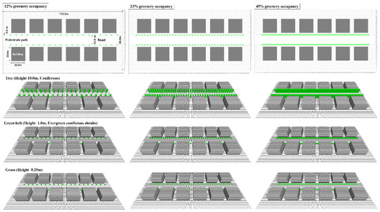
Figure 2.
Overview of the case study model.
Table 3.
Types of roadside greenery.
The analysis was targeted to a height of 1.4 m above the ground, which is the breathing position of pedestrians; it was conducted over the pedestrian path space to examine the effects of car traffic on the urban canyon and temperature changes on the pedestrian path (two places based on the road, total area = 8.0 × 172.0 m).
4. Microclimate and Particulate Matter Parameters under Current Status of Street Greenery Areas
To examine the particulate matter and microclimate parameters of the pedestrian path according to the current status of street greenery areas, the measurement time (10:00, 12:00, 14:00, 16:00, 18:00, and 20:00 LST) was averaged to derive the simulation results, as shown in Table 4.
Table 4.
Simulated results of the changes of the pedestrian environment in the current status of street green.
Among the microclimate parameters, the change in Ta of the pedestrian path appeared to be insignificant (~0.03–0.05 ℃). The WS of the pedestrian road decreased according to the street greenery planning (grass > green belt > tree; ~0.06 to 0.08 m·s−1). The degree of reduction in PET was low in grass and green belts but was larger in other roadside green areas (by ~1.29–1.44 ℃). It may be that, among the different types of street greenery, trees best helped to improve thermal comfort. Meanwhile, the PET results fell within the highest level of extreme heat stress, revealing that the current street greenery planning did not ensure a comfortable pedestrian environment.
Among the particulate matter types; PM10 and PM2.5 increased in the order of grass < green belt < tree. The levels of NO2 and NOx also increased, while that of O3 decreased [39,40].
To examine the effects of meteorological parameters and street greenery planning on microclimate and particulate matter, correlation analysis was conducted using the SPSS V23.0 statistical analysis program. Table 5 shows the results of correlation analysis. Among microclimate parameters, the variable that had the highest positive correlation with PET was insolation (r = 0.833, p = 0.000), followed by Ta (r = 0.677, p = 0.000). This suggests that increased insolation and Ta may increase PET, thereby increasing thermal stress for pedestrians. The atmospheric temperature of pedestrian road (Ta) has a very high positive correlation with Ta (r = 0.991, p = 0.000); it also exhibited correlations with WS (r = 0.592, p = 0.000) and solar radiation (r = 0.544, p = 0.000). Therefore, it is important to find a way to reduce the temperature among the meteorological parameters, so as to reduce Ta.
Table 5.
Effects of meteorological parameters and green space plan for the urban street roadside on microclimate and particulate matter of pedestrian road.
Among the particulate matter types, street greenery planning for the urban roadside was found to affect PM10, PM2.5, NO2, and NOx; it showed low positive correlations with particulate matter (r = 0.332, p = 0.002 for PM10; r = 0.376, p = 0.000 for PM2.5; r = 0.293, p = 0.007 for NO2; and r = 0.277, p = 0.011 for NOx). Among the types of roadside greenery, the levels of PM10, PM2.5, NO2, and NOx were expected to increase in the order of grass, then green belt, then tree. The variables that were predicted to affect O3 were insolation, WS, and street greenery planning for the urban roadside. Insolation showed a relatively high positive correlation with O3 (r = 0.656, p = 0.000), while WS and street greenery planning variables showed low, negative correlations (r = −0.389, p = 0.000 for WS; r = −0.301, p = 0.005 for green space planning).
5. Measures to Improve Pedestrian Environments by Increasing Share of Street Green Areas
This study revealed that it is difficult to ensure a pleasant pedestrian road using current planning practices for street green areas. Therefore, the environmental changes of the pedestrian road were investigated when changing the tree occupancy from 12% (current standard) to 23 or 45%; this variable achieved the best improvement in thermal comfort (PET) among the types of street green areas.
Figure 3 and Figure 4 are graphs showing the results of microclimate and particulate matter factors according to changes in plant occupancy. Figure 5, Figure 6 and Figure 7 show images of microclimate and particulate matter factors corresponding to a floor area ratio of 700% and the time of 12 o’clock in the results. Because thermal comfort changes according to variation in plant occupancy, the PET decreases as the plant occupancy increases on the asphalt of pedestrian roads (~3.50 °C at a floor area ratio of 500% and ~3.04 °C at a floor area ratio of 700%).
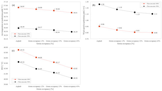
Figure 3.
Changes in microclimate according to increases in tree share. (a) Air temperature at pedestrian path; (b) Wind speed at pedestrian path; (c) PET.
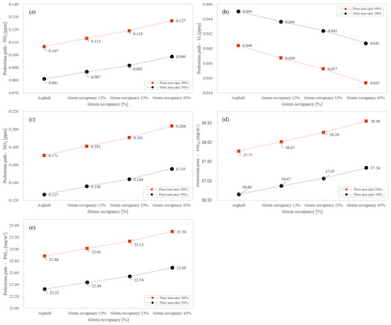
Figure 4.
Changes in particulate matter levels according to increases in tree share. (a) PM10 at pedestrian path; (b) PM2.5 at pedestrian path; (c) NO2 at pedestrian path; (d) NOx at pedestrian path; (e) Ozone at pedestrian path.
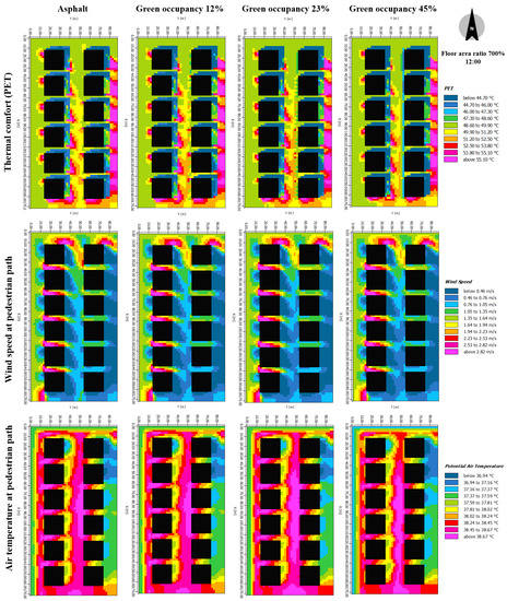
Figure 5.
Analysis result of the micro-climate by increasing share of street green areas.
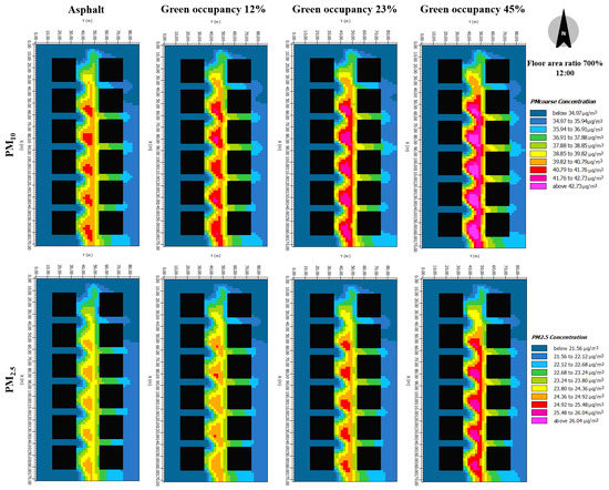
Figure 6.
Analysis result of the particulate matter conditions by increasing share of street green areas (PM10, PM2.5).
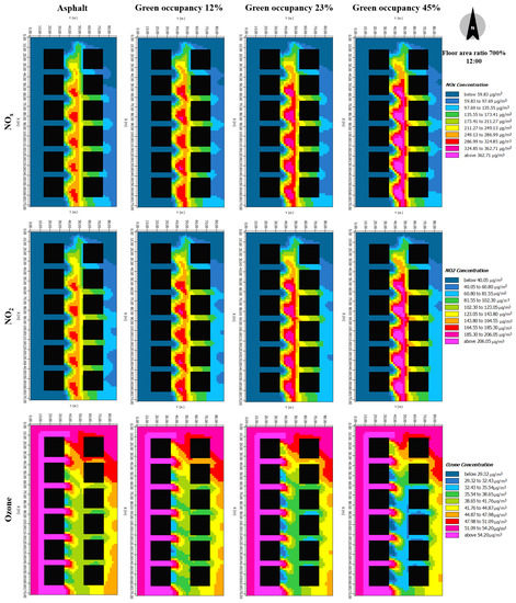
Figure 7.
Analysis result of the particulate matter conditions by increasing share of street green areas (NOX, NO2, Ozone).
The asphalt and plant occupancy rates of 12% and 23% were in the extreme heat stress level (>41 °C). At 45% plant occupancy, the heat stress level changed. At a floor area ratio of 700%, it was 40.20 °C, which is a strong heat stress level. This confirmed that a pleasant walking path environment can be ensured with an increase in the plant occupancy level, whereupon the heat stress level declines.
The atmospheric temperature of the sidewalk decreased by approximately 0.14 °C (floor area ratio of 500%) and 0.10 °C (floor area ratio of 700%) with increasing plant occupancy on the asphalt.
The wind speed along the pedestrian path decreased by approximately 0.10 m/s (floor area ratio of 500%) and 0.15 m/s (floor area ratio of 700%) with increasing plant occupancy on the asphalt.
Among the particulate matter types,
- PM10 concentrations increased by ~0.54 mg·m−3 (floor area ratio = 500%) and ~0.47 mg·m−3 (floor area ratio = 700%) when tree occupancy was increased from 12 to 45%. Over asphalt, it increased by ~0.78 mg·m−3 (floor area ratio = 500%) and ~0.69 mg·m−3 (floor area ratio = 700%).
- PM2.5 concentrations increased by ~0.29 mg·m−3 (floor area ratio = 500%) and ~0.25 mg·m−3 (floor area ratio = 700%) when the tree occupancy was increased from 12 to 45%. Over asphalt, it increased by ~0.41 mg·m−3 (floor area ratio = 500%) and ~0.36 mg·m−3 (floor area ratio = 700%). This relationship appears to be associated with the limited atmospheric circulation (as WS decreased with increasing tree occupancy).
- NO2 concentrations increased by ~0.014 ppm (floor area ratio = 500%) and ~0.012 ppm (floor area ratio = 700%) when the tree share was increased from 12 to 45%. Over asphalt, it increased by ~0.020 ppm (floor area ratio = 500%) and 0.018 ppm (floor area ratio = 700%).
- NOx concentrations increased by ~0.023 ppm (floor area ratio = 500%) and ~0.020 ppm (floor area ratio = 700%) when the tree occupancy was increased from 12 to 45%; over asphalt, it increased by ~0.033 ppm (floor area ratio = 500%) and ~0.029 ppm (floor area ratio = 700%).
- O3 concentrations decreased by ~0.003 ppm (for floor area ratios of 500 and 700%) when the tree share was increased from 12 to 45%; they decreased by ~0.005 ppm (floor area ratio = 500%) and ~0.004 ppm (floor area ratio = 700%) over asphalt.
Thus, increasing the tree occupancy may prolong human interaction with polluted air by reducing the wind speed in urban canyons, thereby impeding dispersion and increasing ground-level pollutant concentrations.
Increasing the tree occupancy was also found here to change the pedestrian environment by decreasing heat stress (i.e., PET levels) and atmospheric temperature. However, the simulation validated that air pollution increased due to the resulting decrease in WS. To ensure a pleasant pedestrian environment with improved microclimate and air pollution levels, it is therefore necessary to develop a plan with eco-friendly materials such as street greenery.
6. Conclusions
Increases in population due to urbanization are leading to increases in artificial coverage rates and exhaust gas emissions, due to the enlarged traffic volume. In urban canyons, high-rise buildings limit the dispersion of vehicle emissions, thereby deteriorating roadside air quality and posing a serious health risk to pedestrians. Dense buildings also worsen thermal comfort. This study was carried out to analyze changes in the microclimate and air quality by setting up a case study of urban street canyons based on the current management status of street trees. Additionally, we determined the present problems with the pedestrian environment and explored ways to improve them.
Stage 1 of the case study evaluated the effects of grass, green belts, and tree materials, which account for high proportions of domestic street green spaces, on microclimate, particulate matter concentrations, and thermal comfort. The spacing and height of street green areas were set based on the current standards of Seoul; the tree occupancy was set to 12% of the pedestrian area, also based on said standards. Stage 2 then simulated the effects of increasing the share of the most influential street greenery type (tree), while examining changes in the pedestrian environment and exploring potential measures for improvement.
The changes in atmospheric temperature of the pedestrian road were found to be insignificant over grass, green belt, and tree, Meanwhile, the WS was found to decrease in the order of grass, green belt, and then tree. Thermal comfort (PET) was found to reduce by 1.29–1.44 °C over tree (compared to asphalt). However, the current standards for street greenery planning were found to be insufficient to lower the heat stress level and secure a comfortable pedestrian environment. Among the particulate matter types, PM10 and PM2.5 were shown to increase over different green space types, in the order of grass, green belt, and tree. In addition, NO2 and NOx levels increased, while O3 concentrations decreased.
Correlation analysis was conducted to examine the effects of meteorological parameters and street greenery types on the microclimate and particulate matter concentrations. Solar radiation was found to be the primary influence on thermal comfort, with a high positive correlation; Ta was also positively correlated. To improve the thermal comfort of pedestrian roads, urban designers should first therefore consider insolation and temperature. Temperature, wind speed, and solar radiation were found to be the biggest influences on the atmospheric temperature of the pedestrian road. Thus, urban designers should consider the Ta as a priority. Street greenery planning for the urban roadside was shown to affect particulate matter concentrations, including PM10, PM2.5, NO2, and NOx. Solar radiation had the strongest effect on O3; wind speed and street greenery planning also had effects.
Stage 2 of the case study was conducted by increasing the tree occupancy on the roadside by 23 and 45%. At 45% occupancy, thermal comfort (PET) decreased by 3.04–3.49 °C dependent on the floor area ratio, confirming that the thermal stress levels were lowered. The atmospheric temperature and wind speed of the pedestrian road also decreased by 0.10–0.14 °C and 0.10–0.15 m·s−1, respectively, dependent on the floor area ratio. Regarding the particulate matter, PM10, PM2.5, NO2, and NOx concentrations all increased with increasing tree occupancy, while O3 decreased as the tree occupancy increased.
The thermal comfort of the pedestrian road improved with increasing tree occupancy due to the accompanying decreases in heat stress and atmospheric temperature. However, the resulting decrease in wind speed led to increased particulate matter concentrations. Although increasing the number of trees in the street greenery planning can improve thermal comfort, it cannot sufficiently improve air quality. To improve the microclimate and air quality, a street greenery plan that takes into account factors that can reduce air pollution is necessary. In future studies, we will adopt various approaches to determine the effects of vegetation on the pedestrian environment and examine changes in the pedestrian path environment according to changes in pavement materials.
Author Contributions
Conceptualization, S.Y. and S.J.J.; methodology, S.Y. and S.J.J.; software, S.J.J.; validation, S.Y. and S.J.J.; formal analysis, S.Y. and S.J.J.; investigation, S.J.J.; resources, S.J.J.; data curation, S.J.J.; writing—original draft preparation, S.J.J.; writing—review and editing, S.Y. and S.J.J.; visualization, S.J.J.; supervision, S.Y.; project administration, S.Y.; funding acquisition, S.Y. All authors have read and agreed to the published version of the manuscript.
Funding
This research was funded by Basic Science Research Program through the National Research Foundation of Korea (NRF) funded by the Ministry of Education (No. NRF-2018R1A6A3A01012661) and the National Research Foundation of Korea(NRF) grant funded by the Korea government (MSIT) (No. NRF-2017R1E1A1A01074904).
Institutional Review Board Statement
Not applicable.
Informed Consent Statement
Not applicable.
Data Availability Statement
Not applicable.
Conflicts of Interest
The authors declare no conflict of interest.
References
- Di Sabatino, S.; Barbano, F.; Brattich, E.; Pulvirenti, B. Multiple-Scale Nature of Urban Heat Island and Its Footprint on Air Quality in Real Urban Environment. Atmosphere 2020, 11, 1186. [Google Scholar] [CrossRef]
- Huang, Y.; Lei, C.; Liu, C.H.; Perez, P.; Forehead, H.; Kong, S.; Zhou, J.L. A review of strategies for mitigating roadside air pollution in urban street canyons. Environ. Pollut. 2021, 280, 116971. [Google Scholar] [CrossRef] [PubMed]
- Sangeun, L.; Myunghwan, S.; Seokjoo, L.; Dahee, H.; Dongik, J.; Jihoon, K.; Taekho, J.; Taewoo, L.; Youdeog, H. Estimation of Link-Based Traffic-Related Air Pollutant Emissions and the Exposure Intensity on Pedestrian Near Busy Streets. J. Ilas. Korea 2018, 23, 81–89. [Google Scholar]
- Heeeun, J.; Bongho, H.; Jeongin, K. A Study on Air Temperature Reduction Effect and the Functional Improvement of Street Green Areas in Seoul, Korea. J. Korean Inst. Landsc. Archit. 2015, 43, 37–49. [Google Scholar]
- Karttuene, S.; Kurppa, M.; Auvinen, M.; Hellsten, A.; Järvi, L. Large-eddy simulation of the optimal street-tree layout for pedestrian-level aerosol particle concentrations—A case study from a city-boulevard. Atmos. Environ. 2020, 6, 100073. [Google Scholar]
- Eniolu Morakinyo, T.; Fat Lam, Y. Simulation study on the impact of tree-configuration, planting pattern and wind condition on street-canyon’s micro-climate and thermal comfort. Build. Environ. 2016, 103, 262–275. [Google Scholar] [CrossRef]
- Abhijith, K.V.; Gokhale, S. Passive control potentials of trees and on-street parked cars in reduction of air pollution exposure in urban street canyons. Environ. Pollut. 2015, 204, 99–108. [Google Scholar] [CrossRef]
- Buccolieri, R.; Salim, S.M.; Leo, L.S.; Di Sabatino, S.; Chan, A.; Ielpo, P.; De Gennaro, G.; Gromke, C. Analysis of local scale tree–atmosphere interaction on pollutant concentration in idealized street canyons and application to a real urban junction. Atmos. Environ. 2011, 45, 1702–1713. [Google Scholar] [CrossRef]
- Gromke, C.; Buccolieri, R.; Di Sabatino, S.; Ruck, B. Dispersion study in a street canyon with tree planting by means of wind tunnel and numerical investigations—Evaluation of CFD data with experimental data. Atmos. Environ. 2008, 42, 8640–8650. [Google Scholar] [CrossRef]
- Jeanjean, A.; Buccolieri, R.; Leigh, R. Air quality affected by trees in real street canyons: The case of Marylebone neighbourhood in central London. Urban For. Urban Green. 2017, 22, 41–53. [Google Scholar] [CrossRef]
- Abhijith, K.V.; Kumar, P.; Gallagher, J.; McNabola, A.; Baldauf, R.; Pilla, F.; Broderick, B.; Di Sabatino, S.; Pulvirenti, B. Air pollution abatement performances of green infrastructure in open road and built-up street canyon environments—A review. Atmos. Environ. 2017, 162, 71–86. [Google Scholar] [CrossRef]
- Buccolieri, R.; Gromke, C.; Di Sabatino, S.; Ruck, B. Aerodynamic effects of trees on pollutant concentration in street canyons. Sci. Total Environ. 2009, 407, 5247–5256. [Google Scholar] [CrossRef] [PubMed]
- Gromke, C.; Ruck, B. On the impact of trees on dispersion processes of traffic emissions in street canyons. Bound. Layer Meteorol. 2009, 131, 19–34. [Google Scholar] [CrossRef]
- Wania, A.; Bruse, M.; Blond, N.; Weber, C. Analysing the influence of different street vegetation on traffic-induced particle dispersion using microscale simulations. J. Environ. Manag. 2012, 94, 91–101. [Google Scholar] [CrossRef]
- Ali-Toudert, F.; Mayer, H. Numerical study on the effects of aspect ratio and orientation of an urban street canyon on outdoor thermal comfort in hot and dry climate. Build. Environ. 2006, 41, 94–108. [Google Scholar] [CrossRef]
- Fahmy, M.; Sharples, S. On the development of an urban passive thermal comfort system in Cairo, Egypt. Build. Environ. 2009, 44, 1907–1916. [Google Scholar] [CrossRef]
- Maggiotto, G.; Buccolieri, R.; Santo, M.A.; Leo, L.S.; Di Sabatino, S. Validation of temperature-perturbation and CFD-based modelling for the prediction of the thermal urban environment: The Lecce (IT) case study. Environ. Model. Softw. 2014, 60, 69–83. [Google Scholar] [CrossRef]
- Jung, S.; Yoon, S. Analysis of the Effects of Floor Area Ratio Change in Urban Street Canyons on Microclimate and Particulate Matter. Energies 2021, 14, 714. [Google Scholar] [CrossRef]
- Hofman, J.; Samson, R. Biomagnetic monitoring as a validation tool for local air quality models: A case study for an urban street canyon. Environ. Int. 2014, 70, 50–61. [Google Scholar] [CrossRef]
- Krüger, E.L.; Minella, F.O.; Rasia, F. Impact of urban geometry on outdoor thermal comfort and air quality from field measurements in Curitiba, Brazil. Build. Environ. 2011, 46, 621–634. [Google Scholar] [CrossRef]
- Morakinyo, T.E.; Lam, Y.F.; Hao, S. Evaluating the role of green infrastructures on near-road pollutant dispersion and removal: Modelling and measurement. J. Environ. Manag. 2016, 182, 595–605. [Google Scholar] [CrossRef]
- Nikolova, I.; Janssen, S.; Vos, P.; Vrancken, K.; Mishra, V.; Berghmans, P. Dispersion modelling of traffic induced ultrafine particles in a street canyon in Antwerp, Belgium and comparison with observations. Sci. Total Environ. 2011, 412–413, 336–343. [Google Scholar] [CrossRef] [PubMed]
- Morakinyo, T.E.; Lam, Y.F. Simulation study of dispersion and removal of particulate matter from traffic by road-side vegetation barrier. Environ. Sci. Pollut. Res. 2016, 23, 6709–6722. [Google Scholar] [CrossRef] [PubMed]
- Samaali, M.; Courault, D.; Bruse, M.; Olioso, A.; Occelli, R. Analysis of a 3D boundary layer model at local scale: Validation on soybean surface radiative measurements. Atmos. Res. 2007, 85, 183–198. [Google Scholar] [CrossRef]
- Chow, W.T.L.; Pope, R.L.; Martin, C.A.; Brazel, A.J. Observing and modeling the nocturnal park cool island of an arid city: Horizontal and vertical impacts. Theor. Appl. Climatol. 2011, 103, 197–211. [Google Scholar] [CrossRef]
- Chow, W.T.L.; Brazel, A.J. Assessing xeriscaping as a sustainable heat island mitigation approach for a desert city. Build. Environ. 2012, 47, 170–181. [Google Scholar] [CrossRef]
- Ng, E.; Chen, L.; Wang, Y.; Yuan, C. A study on the cooling effects of greening in a high-density city: An experience from Hong Kong. Build. Environ. 2012, 47, 256–271. [Google Scholar] [CrossRef]
- Rui, L.; Buccolieri, R.; Gao, Z.; Ding, W.; Shen, J. The Impact of Green Space Layouts on Microclimate and Air Quality in Residential Districts of Nanjing, China. Forests 2018, 9, 224. [Google Scholar] [CrossRef]
- Lee, J.; Kim, Y.; Kim, K.; Kim, S. Estimating clothing thermal insulation using an infrared camera. Sensors 2016, 16, 341. [Google Scholar] [CrossRef] [PubMed]
- Jendritzky, G.; Maarouf, A.; Fiala, D.; Staiger, H. An update on the development of a universal thermal climate index. In Proceedings of the 15th Conference on Biometeorology/Aerobiology and 16th International Congress of Biometeorology, Kansas City, MI, USA, 28 October–1 November 2002. [Google Scholar]
- Matzarakis, A.; Mayer, H.; Iziomon, M. Applications of a universal thermal index. Physiological equivalent temperature. Int. J. Biometeorol. 1999, 43, 76–84. [Google Scholar] [CrossRef] [PubMed]
- Matzarakis, A.; Amelung, B. Physiological equivalent temperature as indicator for impacts of climate change on thermal comfort of humans. In Climatic Change and Human Health; Springer: Dordrecht, The Netherlands, 2008; pp. 161–172. [Google Scholar]
- Mayer, H. Urban bioclimatology. Experientia 1993, 49, 957–963. [Google Scholar] [CrossRef] [PubMed]
- Fu, X.; Liu, J.; Ban-Weiss, G.A.; Zhang, J.; Huang, X.; Ouyang, B.; Popoola, O.; Tao, S. Effects of canyon geometry on the distribution of traffic-related air pollution in a large urban area: Implications of a multi-canyon air pollution dispersion mode. Atmos. Environ. 2017, 165, 111–121. [Google Scholar] [CrossRef]
- Oke, T.R.; Mills, G.; Voogt, A. Urban Climates; Cambridge University Press: Cambridge, UK, 2017; p. 546. [Google Scholar]
- Byon, H.; Han, B.; Ki, K.; Jung, J. Improvement on Street Greenery for the Landscape Specialization and Increase of Green Volume on the Streets of Seoul. J. Korean Inst. Landsc. Archit. 2012, 40, 35–46. [Google Scholar] [CrossRef][Green Version]
- Seong, H. A Study on the Present Status of Urban Roadside Trees by Major Road Types—Focusing on 7 cities in Kyouggi Province. J. Korea Plan. Assoc. 2003, 6, 243–257. [Google Scholar]
- Forestation Guidelines for Particulate Matter Reduction. Available online: https://news.seoul.go.kr/env/square/tree_planting_project/guideline (accessed on 26 January 2021).
- Pettit, T.; Torpy, F.R.; Surawski, N.C.; Fleck, R.; Irga, P.J. Effective reduction of roadside air pollution with botanical biofiltration. J. Hazard. Mater. 2021, 414, 12–14. [Google Scholar] [CrossRef]
- Wang, Y.; Du, H.; Xu, Y.; Lu, D. Temporal and spatial variation relationship and influence factors on surface urban heat island and ozone pollution in the Yangtze River Delta, China. Sci. Total Environ. 2018, 631–632, 921–933. [Google Scholar] [CrossRef]


Publisher’s Note: MDPI stays neutral with regard to jurisdictional claims in published maps and institutional affiliations. |
© 2022 by the authors. Licensee MDPI, Basel, Switzerland. This article is an open access article distributed under the terms and conditions of the Creative Commons Attribution (CC BY) license (https://creativecommons.org/licenses/by/4.0/).