Abstract
Current flood risk management is based on statistical models and assessments of the risk of occurrence over a given time period, although with very short measurement periods, usually following catastrophic events. Ongoing monitoring of basic hydrological (river-water level and streamflow) and climate data are the basis for sustainable water management and long-term flood control planning. The lack of data has proven to be particularly negative during this period of global climate change, when non-seasonal flooding (during summer) is becoming increasingly frequent, and the resulting damage greater. The aim of this study was to analyse the possible use of tree ring width chronologies of trees growing in floodplain areas to reconstruct hydrodynamic variables (river-water level and streamflow). The study analysed the influence of climatic and hydrological variables on the growth of narrow-leaved ash (Fraxinus angustifolia Vahl) in the Sava River basin. The results indicate the significant potential of narrow-leaved ash tree-ring width chronologies to reconstruct the summer streamflows of the Sava River (R2 = 0.45). These results can serve to develop long-term data series on the summer streamflows of the river, thereby enabling better insight into its spatial and temporal dynamics with the goal of more successful, sustainable management of floodplain areas.
1. Introduction
Recent changes in climate have been marked by now standard patterns of increasing air temperature trends and significant changes to the distribution and intensity of precipitation throughout Europe [1,2,3]. Over the past few decades, these climate change patterns and extreme weather events have become more frequent, including heavy, short-term precipitation events that cause flooding as well as fires, droughts, and gale-force winds, all of which cause massive economic damage and irreparable ecological losses.
According to the European Environment Agency [4], a total of 3563 floods were recorded in 37 European countries in the period between 1980 and 2010, some of which were catastrophic [5,6,7,8]. Recent flood events across Europe, such as the flood in the Elbe River catchment area of August 2002, have caused fatalities, made thousands of people homeless, and caused damage amounting to several billion euro [9].
Some predictions forecast a doubling of the incidence of severe flood peaks with return periods above 100 years within the next three decades [10], which will increase damage manyfold [11]. The other extreme is the occurrence of severe droughts, which have regularly appeared throughout Europe over the past 20 years [12,13].
Extreme floods cause substantial economic damages due to direct destruction of agricultural crops and property, and in the worst cases, they also result in human casualties. Better understanding of the annual variability and long-term trends of hydrological factors (streamflow and water levels) is an important component in managing water resources, particularly in the context of adaptation. To better understand the long-term dynamics of flooding and drought, data on river-water levels and streamflow are imperative. Such data can be obtained through various sources such as historical records in the form of archives, newspapers, and journals. Unfortunately, data that includes continuous measurements of water levels and streamflows in large rivers are scarce and primarily limited to short time periods, particularly in Southeast Europe. One way to circumvent this problem is through use of tree rings, either from living trees or from archeological wood.
Research to date has indicated that examining the variability in tree-ring width (TRW) of trees growing in floodplains can allow for a reconstruction of extreme events and hydrological trends far back into the past [14,15,16,17,18]. To the extent of our knowledge, no such reconstructions has been conducted in Southeast Europe. Though Europe is under the constant influence of lowland river flooding, this lack of data and research can be attributed to the wide-scale degradation of floodplain forests in the past, which are a potential source of data for this kind of reconstruction. These types of forests cover less and less area worldwide, and in Europe alone, nearly 90% of the lowland floodplain forests have been degraded by anthropogenic influence over time [4,19]. In addition to being a potential source of useful data for dendrohydrological research, floodplain forests also provide natural flood protection, and research has indicated that after these forests have been cut down, the river streamflow has increased [20,21]. Following recognition of the value of these ecosystems and the threats incurred by their complete loss [22,23], recent efforts have been made to revitalise river courses and re-establish the floodplain forests of Europe.
Lowland floodplain forest ecosystems are among the most sensitive to climate change [24,25] as they are directly dependent on the hydrological regime of lowland rivers. Very rare areas of still relatively preserved floodplain forests can still be found in Southeast Europe. Narrow-leaved ash (Fraxinus angustifolia Vahl) is a widely distributed species in the floodplain areas in Southeast Europe. This tree species is not often studied and therefore has not been recognised as being climate sensitive, particularly not in the sense of reconstructing climatic elements. Narrow-leaved ash is a Mediterranean species found in south and southeastern Europe, north Africa, and west Asia [26]. It colonises river banks and lowlands, and is adapted for both flood and drought conditions. Rare dendrochronological research has indicated its significant sensitivity to both the climatic and hydrological components of climate [27,28,29], though a significant problem lies in the short chronologies of less than 100 years. Reconstructions on the basis of narrow-leaved ash growth have not been made in Europe, though in North America, a study was conducted on black ash (Fraxinus nigra Marsh.) with respect to river streamflow [15].
The aim of this study was to determine the sensitivity of narrow-leaved ash to hydrological and climatic factors and the possibility of using this tree species for long-term reconstruction of these variables.
2. Materials and Methods
2.1. Research Area
The study was conducted in the Lonjsko Polje Nature Park (45.233886° N, 17.066181° E, elevation 90–92 m) in continental Croatia (Figure 1). Lonjsko Polje Nature Park is one of the largest and best preserved natural floodplain areas in Europe.
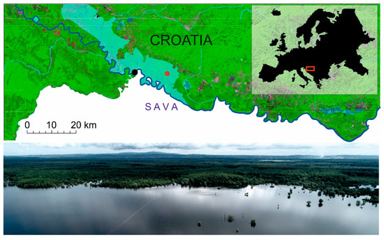
Figure 1.
Study area indicating the position of the Jasenovac measurement station (black dot) and sampling plot (red dot).
The park covers an area of 50,650 ha and is characterised by lowland floodplain forests dominated by narrow-leaved ash (Fraxinus angustifolia Vahl) that covers broad areas of several thousands of hectares. Three dominant microrelief types with their accompanying vegetation alternate in a mosaic fashion in the park area: (a) wet microdepressions with dominant narrow-leaved ash, (b) dry microelevations with dominant common oak (Quercus robur L.), and (c) transitional forms with mixed stands of oak and ash. The relative elevation difference between these microdepressions and microelevations is 1–2 m. The deepest microdepressions are without any forest vegetation due to the long-standing flood waters and, over time, have been completely replaced by permanent wet grasslands. The soil in the study area has characteristics of heavy gley soil which can contain up to 57% clay in the 5–25 cm zone [30].
Sampling for the purpose of this study was performed on a 2500 m2 circular plot in a pure stand of narrow-leaved ash (in a microdepression), at an elevation of 90.5 m, at a distance of 2.9 km from the Sava riverbed. The climate conditions show humid continental characteristics, with a mean annual air temperature of 9.5 °C and an annual total of 890 mm of precipitation. Flooding occurs regularly, at least twice per year (usually in early spring and late autumn), and flood waters may be up to 4 metres high.
2.2. Sample Collection and Data Processing
Samples were collected from healthy, dominant narrow-leaved ash trees using a Pressler increment borer at a height of 1.30 m from ground level. A total of 47 trees were sampled, with two cores per tree. The collected samples were dried in the laboratory, affixed to a wooden base, and then polished using various grades of sandpaper (granulation of 100 to 600).
Tree-ring width (TRW) was measured using the program CooRecorder (Cybis, Sweden) on digital photographs taken using the ATRICS (Advanced Tree-Ring Image Capturing System) system, an automatic measurement table, and digital camera [31]. Further data processing was conducted using the TSAP-Win™ dendrochronological software (Rinntech, Germany). Comparisons and synchronisation of the obtained values of TRWs were performed using a combination of visual and statistical methods. The dating of the measured samples in the individual chronology was performed using the t-values of the correlation coefficient [32] and the Gleichläufigkeit coefficient [33]. Subsequent quality control was performed using the program COFECHA [34]. Finally, dated individual series of TRWs were averaged for each tree (TRWt).
Removing the variability of low frequencies caused by tree age and forest management was performed with ARSTAN [35] using the Spline method of 32 years on previously transformed series (power transformation) [36]. Standardised ring-width series (RWI) were averaged into a single residual chronology calculated using Tukey’s biweight robust mean [37].
The quality of chronology is presented with basic statistical indicators, such as mean inter-series correlation (RBAR), mean sensitivity (MS), autocorrelation (AC), and expressed population signal (EPS). RBAR is the average correlation coefficient between series; MS is a within-series statistic that measures the relative change in ring width from one year to the next, and AC is a measure of the previous year’s influence on the current year’s growth [38]. EPS evaluates the confidence of the chronologies by indicating the degree to which the particular sample chronology portrays a hypothetically perfect chronology based on an infinite number of trees [39].
2.3. Climate Data
Unfortunately, there are no local climate measurement stations in the study area, while the data from surrounding meteorological stations cover only very short time periods. Therefore, we used homogenised series of climate data taken from the database Climate Research Unit (CRU TS3.24.01) [40], with a spatial resolution of 0.5 × 0.5°. Mean values of air temperature (Temp, °C), total monthly precipitation (Prec, mm) and the standardised Palmer drought severity index (scPDSI) were used. This index is a combination of two fundamental variables, i.e., precipitation and temperature [41], though interpolated over a larger spatial scale.
To conduct the correlation analysis of the hydrological variables, we used the mean monthly water level values (R, m.a.s.l.) and streamflow (Q, m3/s) of the Sava River measured at the nearby Jasenovac measurement station (45.266751° N, 16.907375° E) (Figure 1). The hydrological data cover the period from 1927 to 2014, and were obtained from the Croatian Hydrological and Meteorological Institute (DHMZ).
2.4. Correlation Analysis
Correlation analyses were performed between the individual monthly values of hydrological and climatic factors, and the residual chronologies (RWI) created for the period from 1927 to 2014 for a period of 17 months from June of the previous year to October of the current year (jun-OCT). The analysis was performed using the order dcc (correlation function analysis) in the “treeclim” package in R [42], with a reliability interval of 0.05. Correlations were also calculated between the chronology index and the mean seasonal values of climatic and hydrological factors for a season length of two, three, and four months. The temporal stability of the climatic and hydrological signals was calculated using a moving correlation for a 30-year period with a one-year shift, again with the dcc order. The regression model of the reconstruction was tested using the split-period calibration/verification approach that includes calculations of reduction of error (RE), coefficient of efficiency (CE), mean squared error (MSE), and the squared correlation coefficient (R2).
3. Results
3.1. Chronology Statistics
After quality control, a total of 85 from the 94 series of tree-ring widths were processed and dated. Dated individual series were then averaged for each individual tree, resulting in 47 averaged TRWt samples included in the final analysis (Figure 2). The period suitable for climate analysis (EPS > 0.85) was from 1895 to 2015, as the period for which it can be considered to represent the studied population with 85% certainty. The intra-series correlation (RBAR) was 0.70 while the mean sensitivity of standardised series (MS) was 0.30.
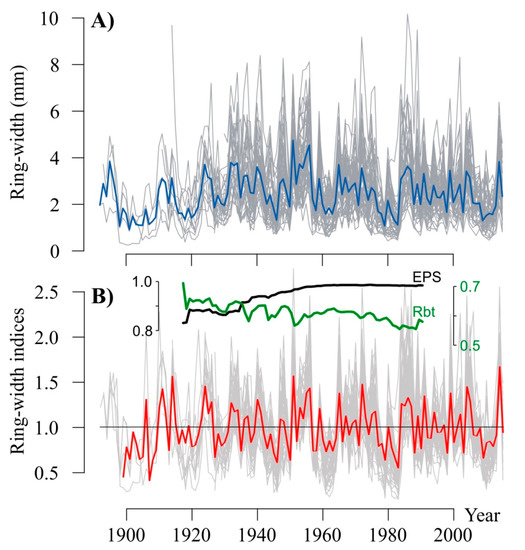
Figure 2.
Tree ring width chronology (dark gray lines—averaged series per tree (TRWt), blue line—average of all TRWt series) (A) and standardised residual chronology (light gray lines—ring-width indices (RWI), red line—average of all RWI series), expressed population signal—EPS (black line) and mean between-tree correlation—Rbt (green line) (B).
3.2. Climate Growth Relationship
The results of the correlation analysis between climatic (temperature, precipitation, and scPDSI) and hydrological variables (water level and streamflow) for the period 1927–2014 indicate a significant (p < 0.05) positive sensitivity of narrow-leaved ash to streamflow (Q) and water level (R) of the Sava River, precipitation (Prec) and the drought index (scPDSI), and a negative correlation with temperature (Temp).
Significant positive correlations were determined with the streamflow (Q) of the Sava River in the period from April to August of the current year, with the highest values in May (r = 0.59), July (r = 0.52), and August (r = 0.55) (Figure 3). Positive correlations were seen for the drought index (scPDSI) for the period from March to October, with maximum values in July (r = 0.57) and August (r = 0.59). A significant possible correlation was also established for water levels (R) from May to August of the current year, which were highest in May (r = 0.51) and August (r = 0.55). Somewhat weaker positive correlations were established for precipitation from April to August, with highest values in April (r = 0.39) and July (r = 0.43). Negative correlations were established for the average temperature from June to August, with the highest values in June (r = −0.36). Correlations with climatic and hydrological variables of the previous year did not show significance.
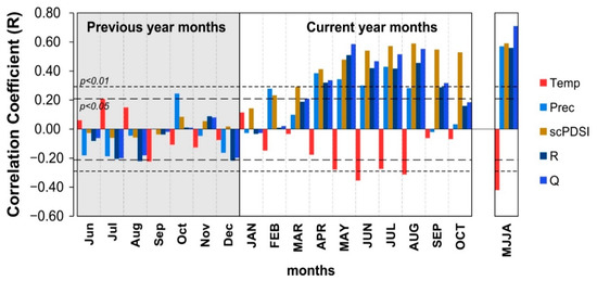
Figure 3.
Values of the calculated correlation coefficients between individual monthly and seasonal (MJJA) climatic and hydrological variables (Temp—temperature, Prec—precipitation, scPDSI—Palmer drought severity index, R—river-water level, Q—streamflow) and the chronology of narrow-leaved ash trees for the period from June of the previous year (Jun) to October (OCT) of the current year of ring formation.
Seasonal correlations indicate somewhat higher values for the 4-month season length. Positive correlations were found with average streamflow from May to August of the current year (QMJJA; r = 071), average value of scPDSI from May to August of the current year (PDSIMJJA; r = 0.59), average value of precipitation from May to August of the current year (PrecMJJA; r = 0.57), average value of river-water level from May to August of the current year (RMJJA; r = 0.56), while negative correlations were found with mean temperature from May to August of the current year (TempMJJA; r = −0.42).
3.3. Temporal Stability of the Climate and Hydrological Signal
Moving correlations were examined for a 30-year period, with a shift period of 1 year for the selected average seasonal value (from May to August) of the climate and hydrological variables that showed significant and high correlation values (Figure 4). The results indicated that the average streamflow (Q) of the Sava River and drought index (scPDSI) had a stable signal over the observed period (1927–2014). Unlike these, the correlations with water level (R), precipitation, and temperature were not stable during the observed period (Figure 4). A drop in the correlation values after 1980 was particularly prominent.
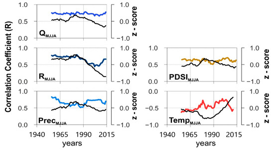
Figure 4.
Results of the moving correlation between residual chronologies (RWI) and selected climate variables (Temp—mean temperature, Prec—sum of precipitation and PDSI—mean drought index for the period May to August) and hydrological variables (Q—mean streamflow and R—sum of river-water level for the period May to August). Standard deviation (Z score) of the 30-year averages of climatic and hydrological variables are shown with the black line for the period from May to August.
3.4. Potential for Streamflow Reconstruction
Significantly (p < 0.05) high and temporally stable correlations were confirmed for the average streamflow of the Sava River from May to August of the year of tree-ring formation, indicating the significant potential of TRW chronologies of narrow-leaved ash for future reconstructions (Figure 3 and Figure 4). The stability of the relationship between streamflow and growth dynamics of narrow-leaved ash trees was then tested using a 45-year calibration and verification period for the mean seasonal values of streamflow with the highest correlation for the May–August period (MJJA) (Figure 5B). Both commonly used measures of the predictive skills for a linear regression model (RE and CE statistics) are highly positive (RE = 0.464; CE = 0.438), regardless of whether the early or the later period is used for the calibration. The total explained variability of the streamflow using the TRW chronologies of narrow-leaved ash was 45% (R2 = 0.454; p = 0.0099) with a relative mean squared error (RMSE) of 48.15 (Figure 5A).
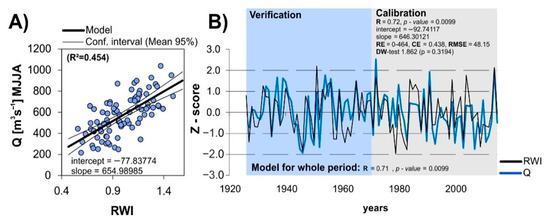
Figure 5.
Regression model of the streamflow (Q), ash chronologies (RWI) (A), and the standard deviation (Z-score) of the average Sava streamflow from May to August, and the ash tree chronologies for the period 1927–2014 (B).
4. Discussion
The study results show the significant sensitivity of the narrow-leaved ash tree-ring width on climatic and hydrological variables. The positive correlation with precipitation was highest in July and in the period from May to August of the current year which is similar to the results of research on common ash (Fraxinus excelsior L.) conducted in northern and central Europe [43,44] and on narrow-leaved ash in southern and southeastern Europe [27,28,29]. The Palmer drought severity index (scPDSI) showed a significant and stable correlation during the observed period.
In considering the monthly correlations, the most important month for the growth of narrow-leaved ash is May. During this month, the highest reliance of tree growth was found on the values of streamflow and water level. This reliance was lower in June, and increased again in July and August when transpiration and moisture deficits were highest. In the ecological sense, streamflow can be considered as being the result of the state of humidity and available water in the ecosystem, which is directly dependent on precipitation and evaporation [45,46], while tree growth represents a complex, integrated reaction to precipitation and temperature [38]. Accordingly, low streamflow rates in the summer period indirectly represent a lack of moisture in the ecosystem, which is a fundamental variable for tree growth [47,48].
The highest significant, positive, and temporally stable correlation was found with the average streamflow in the summer period (May to August), which corroborates similar research on the narrow-leaved ash in Portugal [27]. During this time, the trees experience a deficit in available water, which is further pronounced here due to the characteristics of heavy gley soil. The roots of narrow-leaved ash are shallow and most of them are found in the 5–25 cm zone [49]. For these reasons, narrow-leaved ash has adapted to use available water more efficiently and even though it grows in a floodplain area, drought is the limiting growth factor.
River-water level also showed significant and strong correlations prior to 1980, followed by a decline. This result can be attributed to the drop in river-water levels due to riverbed erosion and reduced quantities of sediment load caused by hydrotechnical works in the upper reaches of the river [50]. Furthermore, the actual reliance of streamflow on water level changed substantially after 1980. Prior to 1980, the average streamflow and water level showed a strong positive correlation (r = 0.99), while this weakened in the period after 1980 (r = 0.73), with greater deviations on the scatterplot (Figure S1, Supplementary Materials). On the other hand, streamflow showed high and stable correlations throughout the whole observed period and was therefore selected for reconstruction.
In Europe, hydrodynamic reconstructions based on TRW are uncommon. Rare research has been done in the UK [51] and more recently in Austria [52]. Research is directed at the reconstruction of climatic variables, primarily temperature and precipitation [53,54,55]. More reconstructions of hydrological variables were done in some other parts of the world, especially in North America. Many of those are streamflow reconstructions using tree-ring widths as a proxy [56,57,58]. These reconstructions are necessary for informing water managers of natural variability with the aim of better management of natural resources—water, forests, and soil. According to several studies in North America [59,60,61], the instrumental records don’t capture the full range of natural variability of streamflow because they are short.
The reconstruction model of the summer streamflows based on the narrow-leaved ash tree-ring chronologies proved to be very successful. The reconstruction successfully identified years of significant changes in streamflow which correspond to known years documented in historic records (for example, 1965 and 1972). The overall explanation of the variability of streamflow using TRWs of narrow-leaved ash was significant, in line with similar research in Europe [52] and North America [58,59,61]. This is the first such research in Southeast Europe and it shows the potential for creating a regional chronology related to tree species of the Danube River Basin.
This study has shown that other tree species, such as narrow-leaved ash, have significant potential for reconstructions. Therefore, future research should be directed at creating long-term chronologies of this species. It is known that the maximum age of narrow-leaved ash in the Sava River basin is 160 years [62], but high potential also lies in the subfossil samples along the course of the Sava River. This could substantially extend the chronologies of tree-ring widths of this species, thereby improving its potential in the reconstruction of hydrological variables. These findings could be applied in the drafting of river-management plans in a manner that is acceptable for the forest ecosystems in this area.
Supplementary Materials
The following are available online at https://www.mdpi.com/2071-1050/13/4/2408/s1, Figure S1. Reliance of streamflow on water level prior to 1980 (A) and after 1980 (B).
Author Contributions
Conceptualization and methodology, D.T. and S.M.; software, A.Ž.; validation, D.T., S.M., A.Ž. and M.O.; field work D.T., A.Ž. and M.O.; writing—original draft preparation, D.T.; writing—review and editing, S.M.; visualization, M.O. All authors have read and agreed to the published version of the manuscript.
Funding
This research received no external funding.
Institutional Review Board Statement
Not applicable.
Informed Consent Statement
Not applicable.
Data Availability Statement
Tree-ring width data file will be available at https://figshare.com/ accessed on 22 February 2021.
Acknowledgments
D.T., S.M., A.Ž. and M.O. were supported by Ministry of Economy and Sustainable Development (Croatia) under the project KK.05.1.1.02.0009 (MEMORIE). D.T. received support from the Croatian National Science Foundation.
Conflicts of Interest
The authors declare no competing interests.
References
- Auer, I.; Böhm, R.; Jurkovic, A.; Lipa, W.; Orlik, A.; Potzmann, R.; Schöner, W.; Ungersböck, M.; Matulla, C.; Briffa, K.; et al. HISTALP—Historical instrumental climatological surface time series of the Greater Alpine Region. Int. J. Climatol. 2007, 27, 17–46. [Google Scholar] [CrossRef]
- Giorgi, F.; Lionello, P. Climate change projections for the Mediterranean region. Glob. Planet. Chang. 2008, 63, 90–104. [Google Scholar] [CrossRef]
- Edenhofer, O. (Ed.) Climate Change 2014: Mitigation of Climate Change; Working Group III Contribution to the Fifth Assessment Report of the Intergovernmental Panel on Climate Change; IPCC; Climate Change 2014; Cambridge Univ. Press: New York, NY, USA, 2014; ISBN 978-1-107-05821-7. [Google Scholar]
- Floodplain Management: Reducing Flood Risks and Restoring Healthy Ecosystems; European Environment Agency: Copenhagen, Denmark, 2016.
- Gaume, E.; Bain, V.; Bernardara, P.; Newinger, O.; Barbuc, M.; Bateman, A.; Blaškovičová, L.; Blöschl, G.; Borga, M.; Dumitrescu, A.; et al. A compilation of data on European flash floods. J. Hydrol. 2009, 367, 70–78. [Google Scholar] [CrossRef]
- Jaun, S.; Ahrens, B.; Walser, A.; Ewen, T.; Schär, C. A probabilistic view on the August 2005 floods in the upper Rhine catchment. Nat. Hazards Earth Syst. Sci. 2008, 8, 281–291. [Google Scholar] [CrossRef]
- Kundzewicz, Z.W.; Pińskwar, I.; Brakenridge, G.R. Large floods in Europe, 1985–2009. Hydrol. Sci. J. 2013, 58, 1–7. [Google Scholar] [CrossRef]
- Floods in the Balkans: Bosnia and Herzegovina, Croatia and Serbia Situation Report; WHO: Geneva, Switzerland, 2014.
- Communication on Flood Risk Management; Flood Prevention, Protection and Mitigation; European Commission: Brussels, Belgium, 2004.
- Alfieri, L.; Burek, P.; Feyen, L.; Forzieri, G. Global warming increases the frequency of river floods in Europe. Hydrol. Earth Syst. Sci. Discuss. 2015, 12, 1119–1152. [Google Scholar]
- Winsemius, H.C.; Aerts, J.C.J.H.; van Beek, L.P.H.; Bierkens, M.F.P.; Bouwman, A.; Jongman, B.; Kwadijk, J.C.J.; Ligtvoet, W.; Lucas, P.L.; van Vuuren, D.P.; et al. Global drivers of future river flood risk. Nat. Clim. Chang. 2016, 6, 381–385. [Google Scholar] [CrossRef]
- Fink, A.H.; Brücher, T.; Krüger, A.; Leckebusch, G.C.; Pinto, J.G.; Ulbrich, U. The 2003 European summer heatwaves and drought -synoptic diagnosis and impacts: European heatwave-impacts. Weather 2004, 59, 209–216. [Google Scholar] [CrossRef]
- Hanel, M.; Rakovec, O.; Markonis, Y.; Máca, P.; Samaniego, L.; Kyselý, J.; Kumar, R. Revisiting the recent European droughts from a long-term perspective. Sci. Rep. 2018, 8, 9499. [Google Scholar] [CrossRef] [PubMed]
- Cook, E.R.; Jacoby, G.C. Potomac River Streamflow Since 1730 as Reconstructed by Tree Rings. J. Clim. Appl. Meteorol. 1983, 22, 1659–1672. [Google Scholar] [CrossRef]
- Kames, S. Sensitivity of Vessels in Black Ash (Fraxinus nigra Marsh.) Tree Rings to Fire and Hydro-Climatic Variables. Master’s Thesis, University of Manitoba, Winnipeg, MB, Canada, 2009. [Google Scholar]
- Perez-Valdivia, C.; Sauchyn, D. Tree-ring reconstruction of groundwater levels in Alberta, Canada: Long term hydroclimatic variability. Dendrochronologia 2011, 29, 41–47. [Google Scholar] [CrossRef]
- Shah, S.K.; Bhattacharyya, A.; Chaudhary, V. Streamflow reconstruction of Eastern Himalaya River, Lachen ‘Chhu’, North Sikkim, based on tree-ring data of Larix griffithiana from Zemu Glacier basin. Dendrochronologia 2014, 32, 97–106. [Google Scholar] [CrossRef]
- Speer, J.H.; Shah, S.K.; Truettner, C.; Pacheco, A.; Bekker, M.F.; Dukpa, D.; Cook, E.R.; Tenzin, K. Flood history and river flow variability recorded in tree rings on the Dhur River, Bhutan. Dendrochronologia 2019, 56, 125605. [Google Scholar] [CrossRef]
- Tockner, K.; Stanford, J.A. Riverine flood plains: Present state and future trends. Environ. Conserv. 2002, 29, 308–330. [Google Scholar] [CrossRef]
- Robinson, M.; Cognard-Plancq, A.-L.; Cosandey, C.; David, J.; Durand, P.; Führer, H.-W.; Hall, R.; Hendriques, M.O.; Marc, V.; McCarthy, R.; et al. Studies of the impact of forests on peak flows and baseflows: A European perspective. For. Ecol. Manag. 2003, 186, 85–97. [Google Scholar] [CrossRef]
- Bradshaw, C.J.A.; Sodhi, N.S.; Peh, K.S.-H.; Brook, B.W. Global evidence that deforestation amplifies flood risk and severity in the developing world. Glob. Chang. Biol. 2007, 13, 2379–2395. [Google Scholar] [CrossRef]
- Hughes, F.M.R.; del Tánago, M.G.; Mountford, J.O. Restoring Floodplain Forests in Europe. In A Goal-Oriented Approach to Forest Landscape Restoration; Stanturf, J., Madsen, P., Lamb, D., Eds.; World Forests; Springer: Dordrecht, The Netherlands, 2012; Volume 16, pp. 393–422. ISBN 978-94-007-5337-2. [Google Scholar]
- Schneider, E. Floodplain Restoration of Large European Rivers, with Examples from the Rhine and the Danube. In Restoration of Lakes, Streams, Floodplains, and Bogs in Europe; Eiseltová, M., Ed.; Wetlands: Ecology, Conservation and Management; Springer: Dordrecht, The Netherlands, 2010; Volume 3, pp. 185–223. ISBN 978-90-481-9264-9. [Google Scholar]
- Horner, G.J.; Baker, P.J.; Nally, R.M.; Cunningham, S.C.; Thomson, J.R.; Hamilton, F. Mortality of developing floodplain forests subjected to a drying climate and water extraction. Glob. Chang. Biol. 2009, 15, 2176–2186. [Google Scholar] [CrossRef]
- Pittock, J.; Hansen, L.J.; Abell, R. Running dry: Freshwater biodiversity, protected areas and climate change. Biodiversity 2008, 9, 30–38. [Google Scholar] [CrossRef]
- Boshier, D. Ash Species in Europe: Biological Characteristics and Practical Guidelines for Sustainable Use; Oxford Forestry Institute: Oxford, UK, 2005; ISBN 978-0-85074-163-6. [Google Scholar]
- Marques, I.C.G. Fraxinus Angustifolia Vahl as a Valuable Species in Riparian Rehabilitation Projects. From Annual Growth to Habitat Preference of Narrow-Leaved Ash in Southern Portugal. Master’s Thesis, ISA-University of Lisbon, Lisboa, Portugal, 2016. [Google Scholar]
- Mikac, S.; Žmegač, A.; Trlin, D.; Paulić, V.; Oršanić, M.; Anić, I. Drought-induced shift in tree response to climate in floodplain forests of Southeastern Europe. Sci. Rep. 2018, 8, 16495. [Google Scholar] [CrossRef]
- Muñoz, N.G.; Linares, J.C.; Castro-Díez, P.; Sass-Klaassen, U. Contrasting secondary growth and water use efficiency patterns in native and exotic trees co-occurring in inner Spain riparian forests. For. Syst. 2015, 24, 017. [Google Scholar]
- Pernar, N.; Anić, I.; Jazbec, A.; Bakšić, D. The degree of soil water saturation in the narrow-leaved ash (Fraxinus angustifolia Vahl.) Floodplain forest. Ekologia 2007, 26, 258–272. [Google Scholar]
- Levanič, T. Atrics–A New System for Image Acquisition in Dendrochronology. Tree-Ring Res. 2007, 63, 117–122. [Google Scholar] [CrossRef]
- Baillie, M.G.L.; Pilcher, J.R. A simple crossdating program for tree-ring research. Tree-Ring Bull. 1973, 33, 7–14. [Google Scholar]
- Schweingruber, F.H. Tree Rings: Basics and Applications of Dendrochronology; Springer: Dordrecht, The Netherlands, 1988; pp. 51–68. ISBN 978-94-009-1273-1. [Google Scholar]
- Holmes, R.L. Computer-assisted quality control in tree-ring dating and measurement. Tree Ring Bull. 1983, 44, 69–78. [Google Scholar]
- Cook, E.R.; Krusic, P.J. Program ARSTAN, a Tree-Ring Standardization Program based on Detrending and Autoregressive Time Series Modeling with Interactive Graphics; Ree-Ring Laboratory Lamont Doherty Earth Observatory of Columbia University: New York, NY, USA, 2005. [Google Scholar]
- Cook, E.R.; Peters, K. Calculating unbiased tree-ring indices for the study of climatic and environmental change. Holocene 1997, 7, 361–370. [Google Scholar] [CrossRef]
- Mosteller, F.; Tukey, J.W. Data Analysis and Regression: A Second Course in Statistics; Addison-Wesley: Boston, MA, USA, 1977; ISBN 978-0-201-04854-4. [Google Scholar]
- Fritts, H.C. Tree Rings and Climate; Academic Press: London, UK; New York, NY, USA, 1976; ISBN 978-0-12-268450-0. [Google Scholar]
- Wigley, T.M.L.; Briffa, K.R.; Jones, P.D. On the average value of correlated time series, with applications in dendroclimatology and hydrometeorology. J. Clim. Appl. Meteorol. 1984, 23, 201–213. [Google Scholar] [CrossRef]
- Harris, I.; Jones, P.D.; Osborn, T.J.; Lister, D.H. Updated high-resolution grids of monthly climatic observations-the CRU TS3.10 Dataset: Updated High-Resolution Grids of Monthly Climatic Observations. Int. J. Climatol. 2014, 34, 623–642. [Google Scholar] [CrossRef]
- Alley, W.M. The Palmer Drought Severity Index: Limitations and Assumptions. J. Clim. Appl. Meteorol. 1984, 23, 1100–1109. [Google Scholar] [CrossRef]
- Zang, C.; Biondi, F. Dendroclimatic calibration in R: The bootRes package for response and correlation function analysis. Dendrochronologia 2013, 31, 68–74. [Google Scholar] [CrossRef]
- Pušpure, I.; Gerra-Inohosa, L.; Matisons, R.; Laiviņš, M. Tree-ring width of European ash differing by crown condition and its relationship with climatic factors in Latvia. Balt. For. 2017, 23, 244–252. [Google Scholar]
- Okonski, B. Radial growth of pedunculate oak and European ash on active river terraces: Hydrologic and climatic controls. Infrastrukt. Ekol. Teren. Wiej./Infrastucture Ecol. Rural Areas 2017, III/1, 1075–1091. [Google Scholar]
- Salas, J.D.; Tarawneh, Z.; Biondi, F. A hydrological record extension model for reconstructing streamflows from tree-ring chronologies: Dendrohydrological record extension model. Hydrol. Process. 2015, 29, 544–556. [Google Scholar] [CrossRef]
- Meko, D.; Stockton, C.W.; Boggess, W.R. The tree-ring record of severe sustained drought. J. Am. Water Resour. Assoc. 1995, 31, 789–801. [Google Scholar] [CrossRef]
- Koprowski, M.; Okoński, B.; Gričar, J.; Puchałka, R. Streamflow as an ecological factor influencing radial growth of European ash (Fraxinus excelsior (L.)). Ecol. Indic. 2018, 85, 390–399. [Google Scholar] [CrossRef]
- Cleaveland, M.K.; Stahle, D.W. Tree ring analysis of surplus and deficit runoff in the White River, Arkansas. Water Resour. Res. 1989, 25, 1391–1401. [Google Scholar] [CrossRef]
- Prpić, B. Korijenov sistem poljskog jasena (Fraxinus angustifolia Vahl) u različitim tipovima posavskih nizinskih šuma. Glas. Za Šumske Pokuse 1974, 17, 253–336. [Google Scholar]
- Kuspilić, N.; Gilja, G. Potencijalan Učinak Morfoloških Promjena Rijeke Save na Zagrebački Vodonosnik; Strategija Razvoja Vodopskrbe i Odvodnje Grada Zagreba: Zagreb, Croatia, 17–18 May 2016; p. 11. [Google Scholar]
- Jones, P.D.; Briffa, K.R.; Pilcher, J.R. Riverflow reconstruction from tree rings in southern Britain. J. Climatol. 1984, 4, 461–472. [Google Scholar] [CrossRef]
- Karanitsch-Ackerl, S.; Mayer, K.; Gauster, T.; Laaha, G.; Holawe, F.; Wimmer, R.; Grabner, M. A 400-year reconstruction of spring–summer precipitation and summer low flow from regional tree-ring chronologies in North-Eastern Austria. J. Hydrol. 2019, 577, 123986. [Google Scholar] [CrossRef]
- Buntgen, U.; Tegel, W.; Nicolussi, K.; McCormick, M.; Frank, D.; Trouet, V.; Kaplan, J.O.; Herzig, F.; Heussner, K.-U.; Wanner, H.; et al. 2500 Years of European Climate Variability and Human Susceptibility. Science 2011, 331, 578–582. [Google Scholar] [CrossRef]
- Raffalli-Delerce, G.; Masson-Delmotte, V.; Dupouey, J.L.; Stievenard, M.; Breda, N.; Moisselin, J.M. Reconstruction of summer droughts using tree-ring cellulose isotopes: A calibration study with living oaks from Brittany (western France). Tellus B Chem. Phys. Meteorol. 2004, 56, 160–174. [Google Scholar] [CrossRef]
- Čufar, K.; De Luis, M.; Eckstein, D.; Kajfež-Bogataj, L. Reconstructing dry and wet summers in SE Slovenia from oak tree-ring series. Int. J. Biometeorol. 2008, 52, 607–615. [Google Scholar] [CrossRef]
- Woodhouse, C.A. A tree-ring reconstruction of streamflow for the colorado front range. JAWRA J. Am. Water Resour. Assoc. 2001, 37, 561–569. [Google Scholar] [CrossRef]
- Woodhouse, C.A.; Lukas, J.J. Multi-Century Tree-Ring Reconstructions of Colorado Streamflow for Water Resource Planning. Clim. Chang. 2006, 78, 293–315. [Google Scholar] [CrossRef]
- Anderson, S.; Ogle, R.; Tootle, G.; Oubeidillah, A. Oubeidillah Tree-Ring Reconstructions of Streamflow for the Tennessee Valley. Hydrology 2019, 6, 34. [Google Scholar] [CrossRef]
- Allen, E.B.; Rittenour, T.M.; DeRose, R.J.; Bekker, M.F.; Kjelgren, R.; Buckley, B.M. A tree-ring based reconstruction of Logan River streamflow, northern Utah: Logan river reconstruction. Water Resour. Res. 2013, 49, 8579–8588. [Google Scholar] [CrossRef]
- Barnett, F.A.; Gray, S.T.; Tootle, G.A. Upper Green River Basin (United States) Streamflow Reconstructions. J. Hydrol. Eng. 2010, 15, 567–579. [Google Scholar] [CrossRef]
- Watson, T.A.; Anthony Barnett, F.; Gray, S.T.; Tootle, G.A. Reconstructed Streamflows for the Headwaters of the Wind River, Wyoming, United States. JAWRA J. Am. Water Resour. Assoc. 2009, 45, 224–236. [Google Scholar] [CrossRef]
- Oršanić, M.; Mikac, S.; Ugarković, D.; Drvodelić, D.; Diminić, D.; Kranjec Orlović, J.; Milotić, M.; Hrašovec, B.; Franjević, M.; Vucelja, M.; et al. Ekologija, Obnova i Zaštita Poplavnih Šuma Posavine; Sveučilište u Zagrebu, Šumarski Fakultet: Zagreb, Croatia, 2020. [Google Scholar]


Publisher’s Note: MDPI stays neutral with regard to jurisdictional claims in published maps and institutional affiliations. |
© 2021 by the authors. Licensee MDPI, Basel, Switzerland. This article is an open access article distributed under the terms and conditions of the Creative Commons Attribution (CC BY) license (http://creativecommons.org/licenses/by/4.0/).