
Transport Inequalities and the Adoption of Intelligent Transportation Systems in Africa: A Research Landscape


Abstract
1. Introduction
- We reveal the status of ITS in Africa, including the number of articles published in the subject area, country-level progress and the specific types of research on ITS being undertaken in Africa.
- We identify cross-cutting connections between published articles.
- We develop a hybrid multi-criteria model that does not rely on expert opinions but instead uses features from the Analytical Hierarchical Process (AHP) as input for a Decision Making Trial and Evaluation (DEMATEL) model. This unique hybrid model is then used to reveal research gaps for future research works in the area of African ITS.
- We discuss the unique challenges of the African transportation landscape.
- We propose a conceptual architecture for an Integrated Intelligent Transportation System suitable for African nations.
2. Review of Related Works
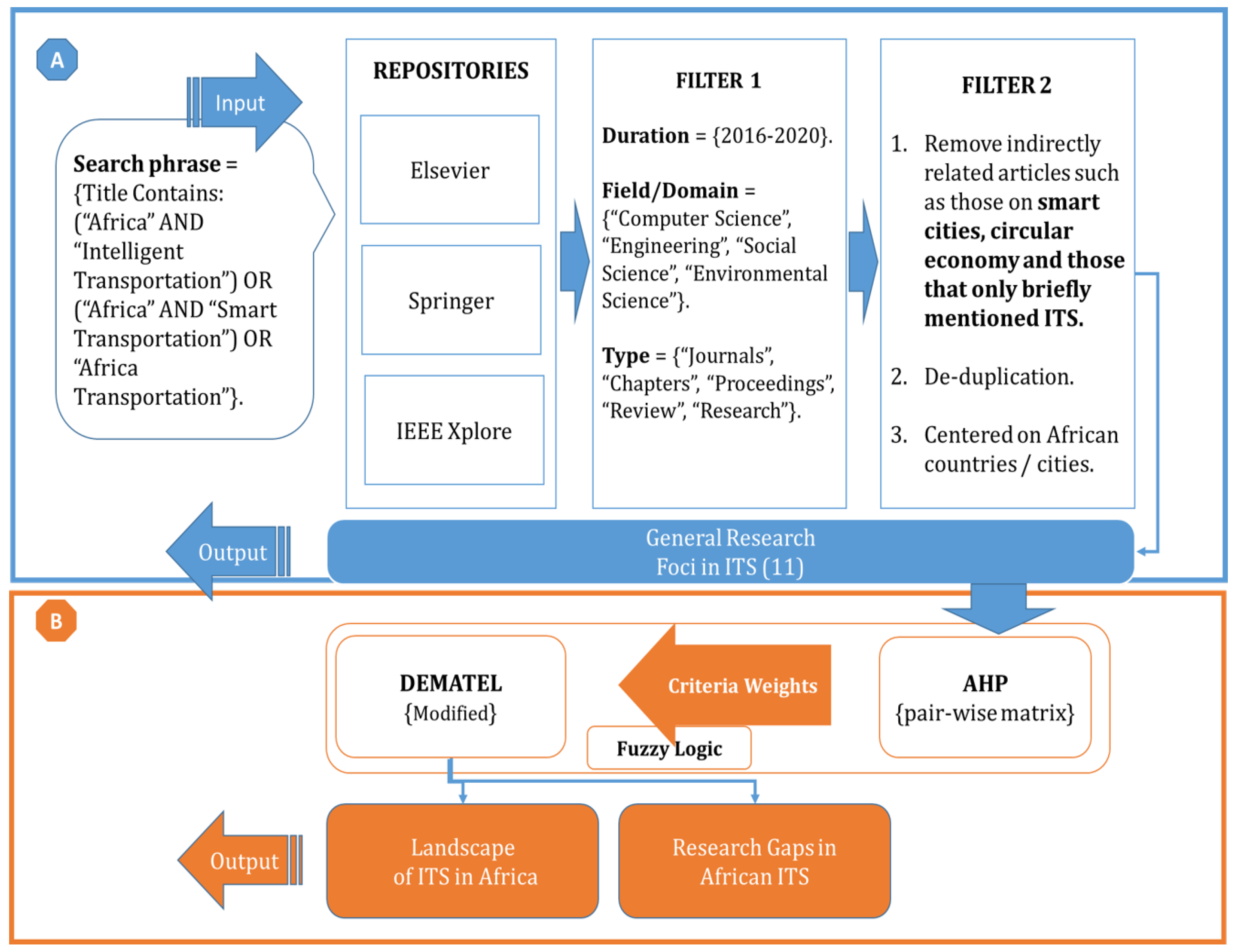
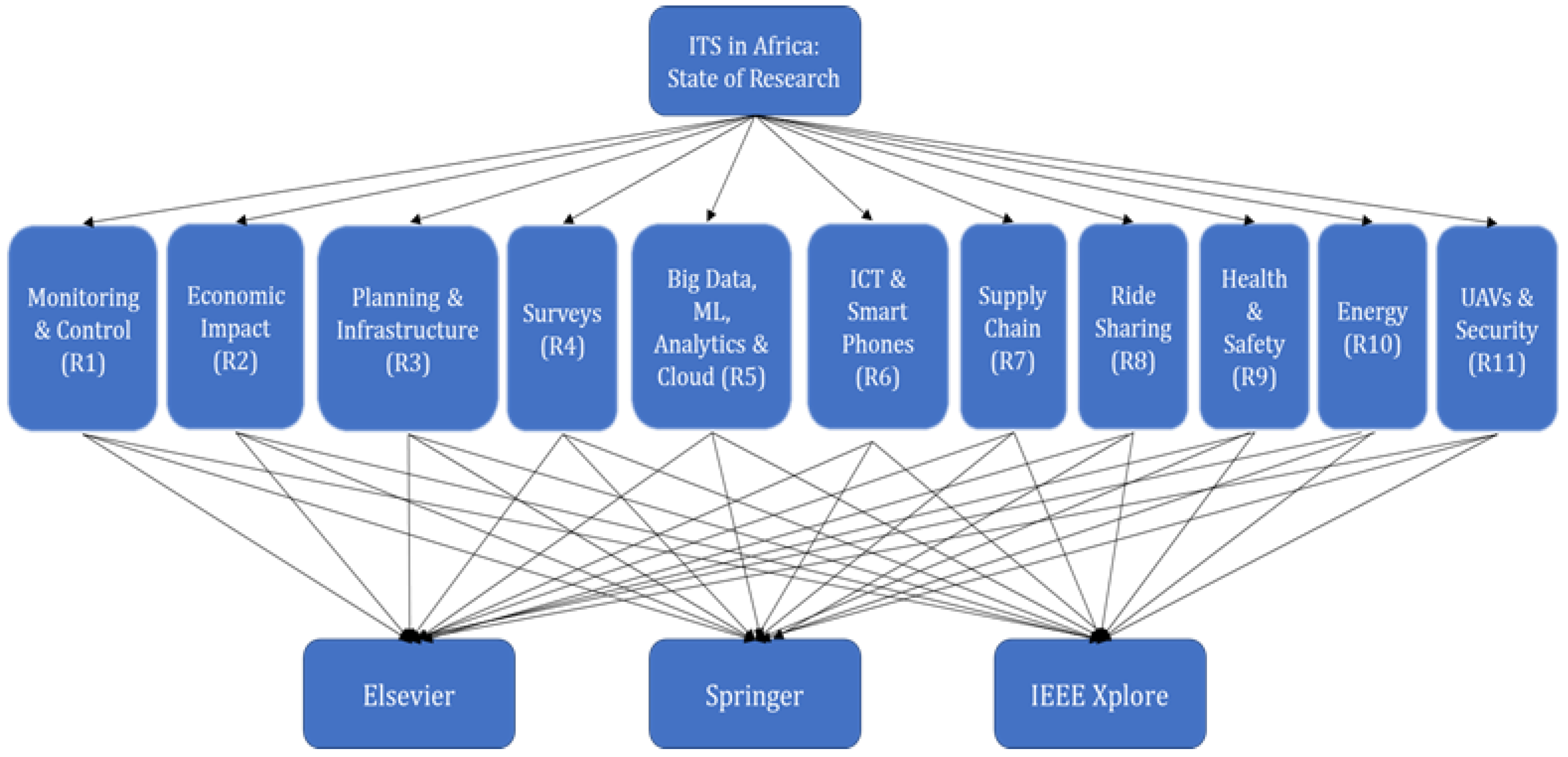
3. Methodology
- Data Collection:This step involves collecting publications on or related to ITS in Africa. We used three repositories as our data sources: Elsevier, Springer and IEEE Xplore. These were chosen because they are arguably the three most common publishers of journals, conference proceedings and book chapters. Two keywords—“intelligent transportation” and “smart transportation”—were used as our search phrases. We selected four fields of study—“Computer Science”, “Engineering”, “Social Science” and “Environmental Science”—as most of the publications on ITS in Elsevier were in these fields. To ensure recency, we only selected publications within the last five years (2016–2020). For both search phrases, we found 11,789 and 12,847 results, respectively, in Elsevier.
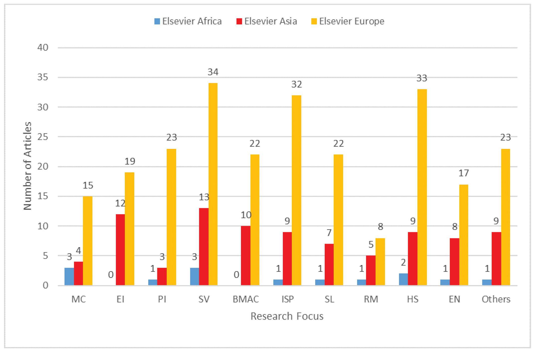
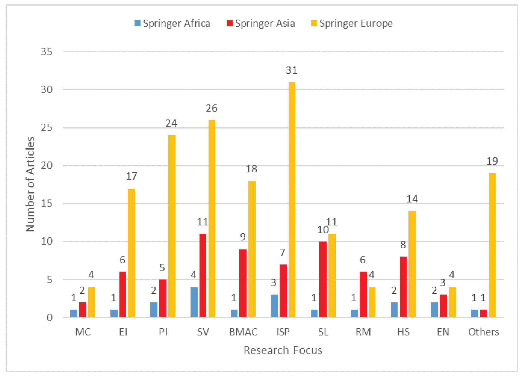
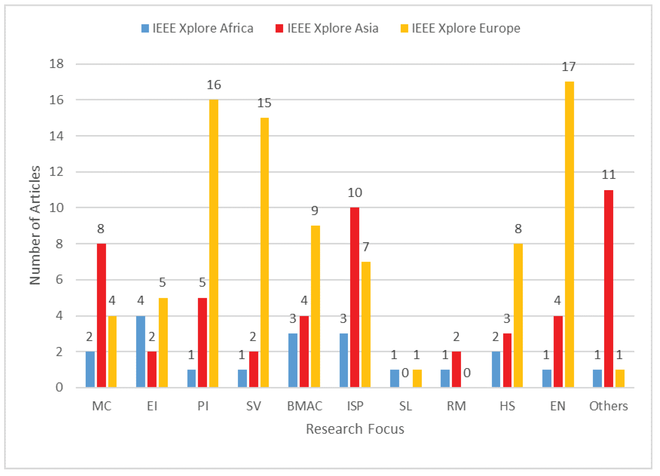
- Filtration: In filtering results from the Elsevier repository, we narrowed down our search by including “Africa” in the search phrases; that is, “Africa Intelligent Transportation” and “Africa Smart Transportation”. These resulted in 1277 and 605 results, respectively. We then merged both phrases into “Africa” AND “Intelligent” OR “Smart” “Transportation”. After removing duplicates, we were left with 315 unique publications comprising reviews, research articles and book chapters. Finally, we read through each title, abstract and key/index words to filter out irrelevant or non-directly related articles, particularly those that only briefly mentioned ITS or discussed it as a subset of a larger smart city ecosystem. This narrowed our result to 56 articles, 14 of which were explicitly focused on ITS in an African context [16,17,18,19,20,21,22,23,24,25,26,27,28,29].We also considered Springer and IEEE Xplore, both of which often publish proceedings of conferences hosted in Africa, such as the EAI Africomm, IST-Africa and Information Communications Technology and Society (ICTAS). Similar data collection and filtration processes to those performed with Elsevier were repeated for both repositories. For Springer, 19 articles were returned, while IEEE Xplore yielded 20 articles primarily focused on ITS in Africa.For comparison purposes and to show the sharp contrast and inequality in ITS research in Africa compared to the rest of the world, we repeated the same search (and filtration) process for Europe and Asia. It was observed that while there were only 14 articles relating to ITS in Africa published in Elsevier, there were about 248 relating to European ITS and 89 for ITS in Asia. A similar trend was also observed with the IEEE Xplore repository, with about 83 published articles on ITS in Europe and 51 on ITS in Asia. These numbers are more than double the number of published articles in IEEE Xplore on ITS in Africa (20). Finally, for Springer, there were 172 and 68 articles published on European ITS and Asia ITS, respectively—a huge difference from the mere 19 on African ITS.
- Phase 1 Output: In total, between 2016 and 2020, there were 503 articles on ITS in Europe, 208 on Asian ITS and only 53 articles on ITS in Africa published in the 3 libraries considered. Since the focus of this study is on African ITS, we would cite articles relating to Africa, while for Asia and Europe, we would only state the cumulative of articles rather than citing the individual articles. A concise summary of the research foci and corresponding article counts is given on Table 2. These were then fed into phase 2 (labelled B in Figure 2), where multi-criteria analysis was carried out.
- Phase 2: The processes carried out in phase 2 are briefly enumerated here but detailed in Section 5.
- -
- Construction of pair-wise matrix from phase 1’s output;
- -
- Calculation of scaled criteria weights;
- -
- DEMATEL analysis;
- -
- Output the research landscape and gaps in African-ITS.
4. Research Findings-Systematic Review
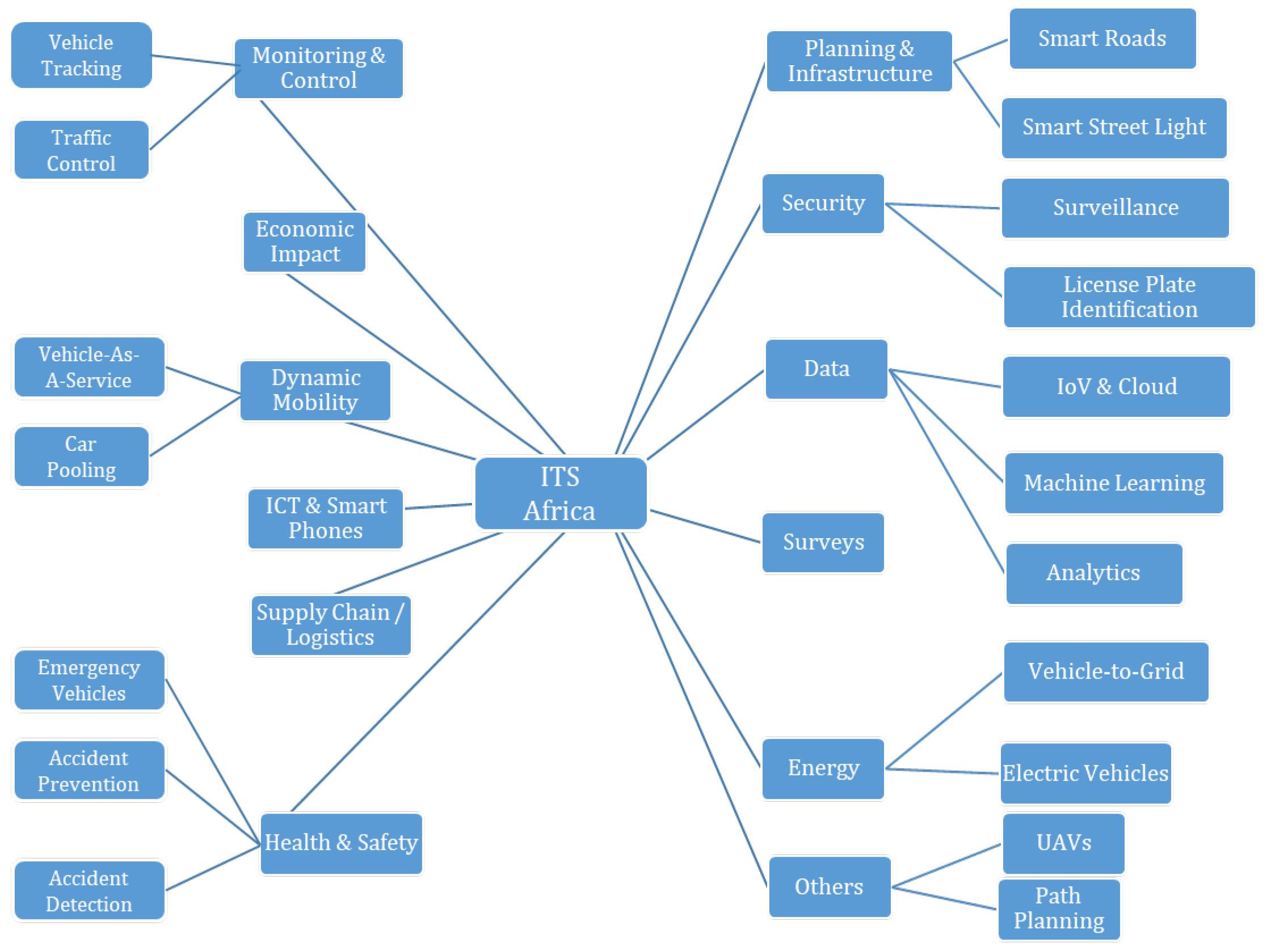
4.1. Taxonomy of ITS Research in Africa
- Monitoring and Control: These are research works that focus on monitoring and controlling road traffic in real-time. The authors in [17] proposed an ITS communication architecture for traffic surveillance in developing countries by concentrating on areas prone to accidents. They began by using a dual control point system (Treatment and Relay Control Points) to collect traffic information. Using these control points, they proposed a low-cost solution for traffic surveillance. The optimal placement of these control points was modelled as a multi-objective problem and was solved using a variant of the Genetic algorithm. In [16], the authors reviewed the state of traffic control systems in Johannesburg, South Africa. The authors reported on the effect of traffic congestion in the city and the impact ITS can have at “un-signalised junctions”. This was done by collecting relevant data and employing artificial intelligence in vehicle-to-vehicle communication and decision making. In [18], the poor luminosity of traffic control lights was considered as a potential cause of driver violations. To tackle this, the authors designed a hybrid lighting system made up of halogen and Light Emitting Diode (LED) lights. The proposed solution was bright enough to attract drivers’ attention and overcome surrounding ambient lights yet remain energy efficient. In [4], the authors proposed a smart traffic light system based on computer vision. Their proposal was to fit traffic lights with light-weight cameras to dynamically capture the road situation as images. The images were then run through a Single Short Detector (SSD) image processing algorithm to obtain traffic density, which was then used to adjust the timing sequence of the traffic lights. To measure the efficiency of their system, they considered traffic intersections as an M/M/1 machine and compared their solution with the classic Round-Robin algorithm used in “dumb” traffic lights. In a similar work, the authors in [30] worked on traffic light preemption for medical emergency vehicles (MEV). They considered multiple traffic lights along an MEV’s path to/from a hospital and modelled these as a Jackson queue of machines. Their proposed model was able to detect an MEV and switch the traffic light to green in order to eliminate/reduce delays along the MEV’s path. In [31], a marine radar-based solution for monitoring maritime traffic congestion along the Congo River Basin was proposed. When bench-marked against the classic solution, it was shown that the proposed solution was able to use radar images to survey and provide real-time information about traffic, which was used to improve traffic coordination, safety and management.
- Economic Impact: Mboup in [32] discussed various opportunities of ICT in urban smart cities and used Dakar in Senegal as a case study. The author focused on a number of issues in the city including flooding and traffic congestion, which have adverse effects on the economy. In addressing the traffic issue, the author reported that solutions such as the PDU 2025 urban mobility plan had been put in place; however, plans for road constructions were omitted. Identified benefits of ICT in Dakar’s transportation included real-time passenger information, which could help guide the scheduling and incorporation of big data analytics, which can help efficiently manage transportation assets, improve safety, reduce traffic congestion and by extension boost the city’s economy. In many parts of sub-Saharan Africa, land-based haulage is primarily conducted through the use of trucks. In [33], the authors presented an empirical model for conserving fuel by considering factors such as route, traffic conditions, driving habit, truck engine size, etc. The authors then determined the impact of each factor on fuel consumption and used a linear regression model to predict consumption levels for new routes. In a similar work, the authors in [34] studied the impact of road inclination and payload on fuel consumption in truck haulage; while in [35], the authors considered a model to enforce compliance with highway speed limits through fuel-saving incentives. It was observed that by driving in a fuel-saving manner, minibus drivers in South Africa could potentially increase their weekly revenue by almost 200%. In [36], a model for determining the economic viability of maritime tyre shipping across ports in South Africa was developed.
- Planning and Infrastructure: In [19], the impact of autonomous vehicles on public roads was considered through the use of accelerated pavement testing data. Guidelines for utilising the data to ensure that pavement structures are able to support additional usage by autonomous vehicles were given. In [37], the authors considered the classic Vehicle Ad Hoc Network (VANET) and noted one of its major shortcomings, which is the slow detection of events on the road, possibly because of high mobility or the low number of road side units. To tackle this, they proposed a hybrid combination of VANET and Wireless Sensor Networks (WSN). This combination enabled the easy monitoring of road condition and infrastructure. The work was concluded with discussions on application areas, communication protocols and potential future directions. The authors in [39] developed a model that utilised a smartphone to collect and disseminate information about the status of road infrastructure in Kenya in a manner that conserves data.
- Surveys: The majority of the articles on ITS in Africa are surveys, though they investigate diverse subject areas. For instance, in [20], the focus was on adapting transportation models from advanced countries into developing countries. They discussed the challenges of implementing ITS in Africa, surveyed road transport network models and proposed solutions for monitoring traffic on inter-urban roads in Africa. In [22], the authors carried out an analysis of the perceived quality of service of bus mobility using Ghanaian students as a case study. In [40], the focus was on infrastructure to support ITS in Dakar, Senegal, and the authors discussed classical versus contemporary means of transportation as well as the role of BRT as a transition medium. Finally, ICT was identified as a key enabler for ITS, and key steps taken by the Senegalese government to support ICT development in Senegal were discussed. In [41], the authors focused on the status of ITS in Ethiopia and gave suggestions for progression. In [43], the authors discussed the influence of ITS on road freight in Zimbabwe, while the role of the IoT in vehicular technology in Egypt was the focus of discussion in [42].
- Big Data, ML, Analytics and Cloud: In [44], fog computing was used to evaluate the performance of a surveillance application that accepts feeds from multiple cameras and tracks multiple vehicles simultaneously. The higher the number of vehicles being monitored, the more computation resources were used, and this was primarily because of network bandwidth utilisation. In [45], the authors applied two variants of the Cuckoo search optimisation algorithm to tackle the short single-loop limitation of VANET. The proposed models performed well when bench-marked against two variants of the Genetic algorithm, particularly in cases of medium to high vehicular density. A driver advisory system was proposed in [46], which used machine learning algorithms to provide information about points of interest along roads that are unfamiliar to drivers. These points of interest might include speed-limited zones, speed breaks and poorly lit areas. The advisory system was deployed on an Android smartphone and incorporated text-to-speech support. A similar auditory solution was proposed in [47] but as an intelligent speed notification system, which repeatedly warned drivers against speeding. In [67], minibuses were proposed as alternatives to GSM for “transporting” data from smart meters to control centers.
- Role of ICT and Smart Phones: Two pedestals upon which ITS stands are ICT and smart phones. The following works discussed their roles in African ITS. In [23], the authors surveyed the complementary relationship between telecommunication and transport (road and rail) in Ghana. Bashingi et al. [48] discussed various challenges of integrating ICT into the public transportation systems in a major city in South Africa. Some of the identified issues were finance, vandalism, driver distraction and cellular network coverage. The authors then suggested training, law enforcement and improving ICT infrastructure as potential solutions. Bashingi et al. [49] discussed the utilisation of ICT in transportation in cities in Botswana and South Africa. The level of knowledge among passengers about the potentials of ICT in transportation and their willingness to use it were some of the focus areas. The work also discussed the status of ICT in these cities and its capacity to support transportation. The authors in [51] investigated the application of smartphones in determining driving behaviours influenced by road conditions in Kenya. It was inferred that the presence of potholes, unlabelled speed bumps and similar obstacles influenced driving patterns and consequently impacted on insurance (in the context of Usage-Based Insurance). Their proposed model utilised sensors in the smartphone to collect relevant data and then analysed the data to obtain a real-world representation of actual driving scenarios. In [52], Android-based smartphones were used to pre-empt traffic lights for emergency vehicles such as ambulances, while Wang and his team presented a model that utilised smartphones to map out strategies for designing national and regional roads in Senegal [53]. Their model gathered data about passenger movement from their smartphones, analysed the data and produced an optimised road network.
- Supply Chain and Logistics: The authors in [54] presented a framework which integrates multiple low-cost IoT platforms for information gathering and the management of fleets of public transportation vehicles in a South African city. With regards to the indoor transportation of goods, such as within factories, laboratories and malls, [24] developed a sensor-based hybrid multi-purpose cart-trolley. The carts are fitted with proximity sensors and are capable of being controlled remotely via a smart phone application. In addressing issues relating to cargo losses and lack of real-time information about perishable goods, [55] presented a model that combined Radio Frequency Identification (RFID) sensors with a neural network. Passing the data collected from the RFID sensors to the neural network model, the authors were able to monitor the current temperature of perishable goods in real-time as well as better estimate future temperature variations.
- Ride Hailing and Smart Mobility: There is a growing call for vehicle on-demand and vehicle-as-a-service approaches among the younger generation. These services give passengers access to means of transportation from anywhere and at any time without the hassles and recurrent expenses associated with owning and maintaining vehicles. From an African perspective, Yasin et al., in proposing a solution to the growing population and mobility challenges in Tunisia, studied the acceptability of an alternate e-minibus transport system [25]. They considered social factors, such as the road worthiness certificate of the vehicles, identity and gender of the driver, driving speed, affordability, availability and reliability, as critical to the acceptance of this means of transportation. In the work done in [57], the authors sought to aggregate data about the travel patterns and demands of passengers in Senegal. To achieve this, they used location data extracted from smartphones to obtain an origin–destination matrix, from which travel demand patterns could be inferred. In [56], travel patterns and characteristics of Uber passengers in South Africa were studied. The study was based on online surveys and gave insights into the locations and average travel distances of commuters.
- Health and Safety: From the health and safety perspective of ITS commuters, [26] carried out a survey of published articles. The authors presented a landscape of healthcare from the perspectives of medical emergency vehicles, autonomous vehicles and the potential roles (and advantages) of robots as vehicle drivers. In [27], the authors developed a model to evaluate risky driving behaviours by combining data extracted from an accelerometer and speedometer. Their model enabled them to detect both acceptable and non-acceptable driving behaviour as well as to detect the shortcomings of other thresholds suggested in literature. In assessing the actual cost implications of road accidents and collisions, Makaba et al. proposed a framework based on the Bayesian network that took into consideration expert opinions as well as actual road accident data [58]. In [59], the authors surveyed the role of the IoT in road safety including determining the ideal braking distance and driver negligence detection, as well as weather and other factors that could help avoid road accidents. In [60], a tripartite framework for accident prevention in Morocco was presented. The three factors considered by the framework were human, environmental and vehicular factors, though emphasis was placed more on the vehicular factor.
- Energy: In the work of Maduekwe et al. [28], the authors sought to examine the current transportation situation in Lagos, Nigeria and proposed a transformative solution for energy and greenhouse gas emission. To achieve this, they employed the Long Range Energy Alternative Planning (LEAP) and concluded that the 50% emission target of 2032 can only be reached by reducing the limits on vehicle age to 22 years and maintaining a vehicle growth rate of 2%. With regards to fossil fuel and the roles of electric vehicles in ITS in Africa, [63] presented the state of affairs on Africa’s readiness for the shift from carbon-based fuel to renewable alternatives. Noting that availability and wide access to energy are still limiting factors crippling many African economies, the authors presented some of the efforts being taken, mitigating issues and potential paths for progress. In [62], the authors investigated the penetration of electric vehicles in South Africa, including the impact these vehicles have on the already stretched electricity grid as well as the transport sector in general; conversely, [64] discussed a number of advantages of electric vehicles, including powering homes (vehicle-to-grid).
- Others: In [29], the path planning and navigation of autonomous drones was presented. In their work, they considered a use case of fire detection and relied on numerous sensors including accelerometer, gyroscope and air composition sensors to achieve real-time navigation while taking altitude and distance into consideration. In [65], a dynamic broadcast storm mitigation algorithm was proposed as an alternative to cooperative awareness messages to enhance inter-vehicular communication in Vehicle Ad Hoc Networks, especially during traffic congestion. From a security perspective, [66] proposed a model for license plate recognition using images from open/crowd-sourced cameras. In order to enhance the images from these cameras, the authors proposed a model that considered factors relating to the environment such as ambient lightning conditions and those relating to the cameras (lens, aperture size, image sensor and angles and motion blur effects). By using an opto-electronic model, the authors were able to select the cameras that gave the best images suitable for license recognition.
4.2. Cross-Cutting Connection
5. Research Findings—Multi-Criteria Analysis
5.1. Multi-Criteria Analysis of African ITS
- The use of weighted publication counts rather than expert opinions as inputs to the DEMATEL model (steps 1–6);
- The slight modification of the DEMATEL model to use row–column relationships and inverse-relationships at the first phase rather than expert opinions (steps 7 and 8), and this was borrowed from AHP. In justifying this, if we assume that an article can only be published in a single place (book, journal or proceedings), then there exists a binary dependency relationship between these articles. AHP works best with dependent entities, and since our assumption often holds true in reality, then our model can be assumed to be applicable in this respect.
5.2. Results of Multi-Criteria Analysis
5.2.1. Criteria Weights Using AHP
| Algorithm 1 Modified DEMATEL Analysis Algorithm. |
|
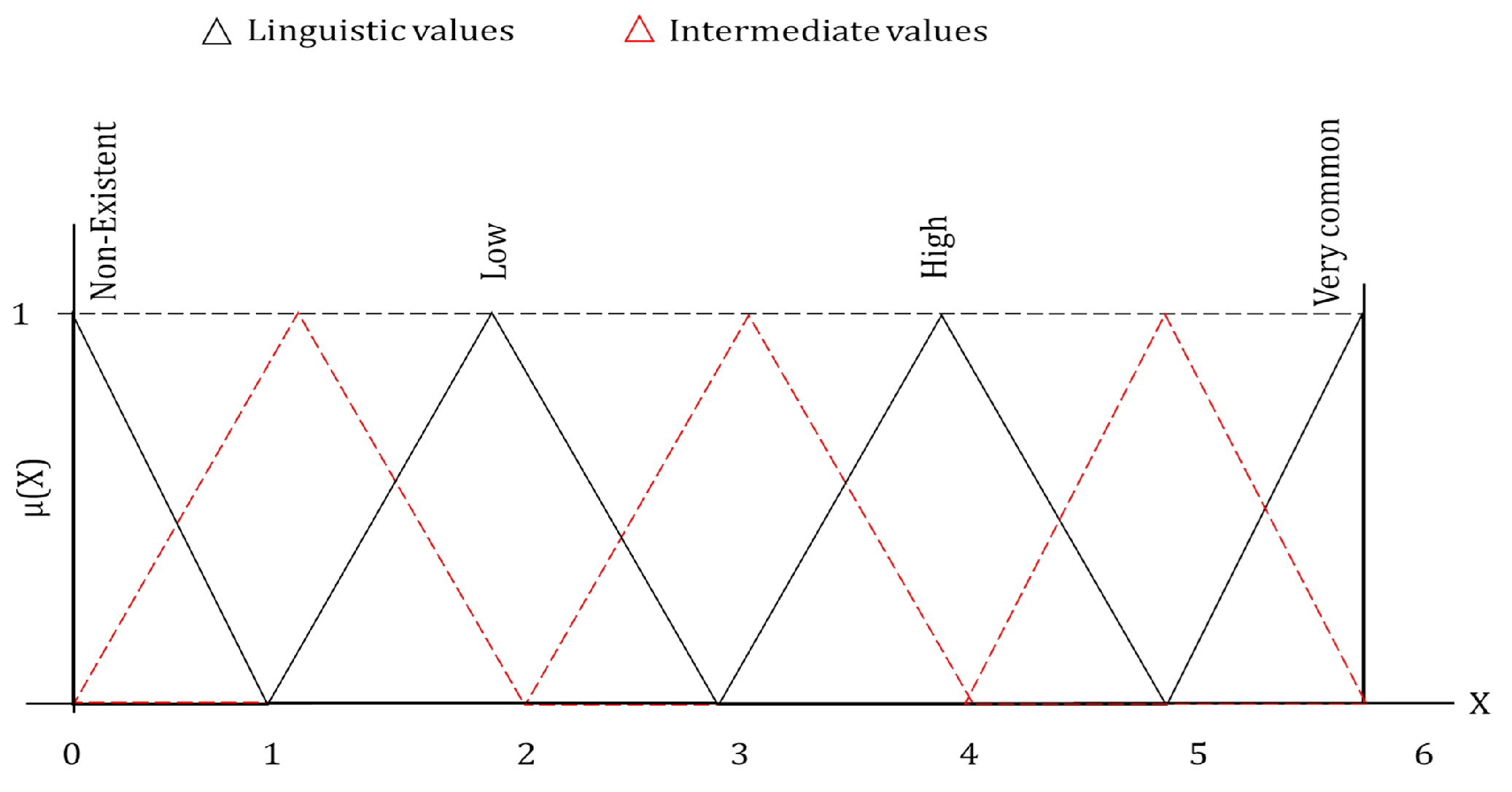
5.2.2. Fuzzification Process
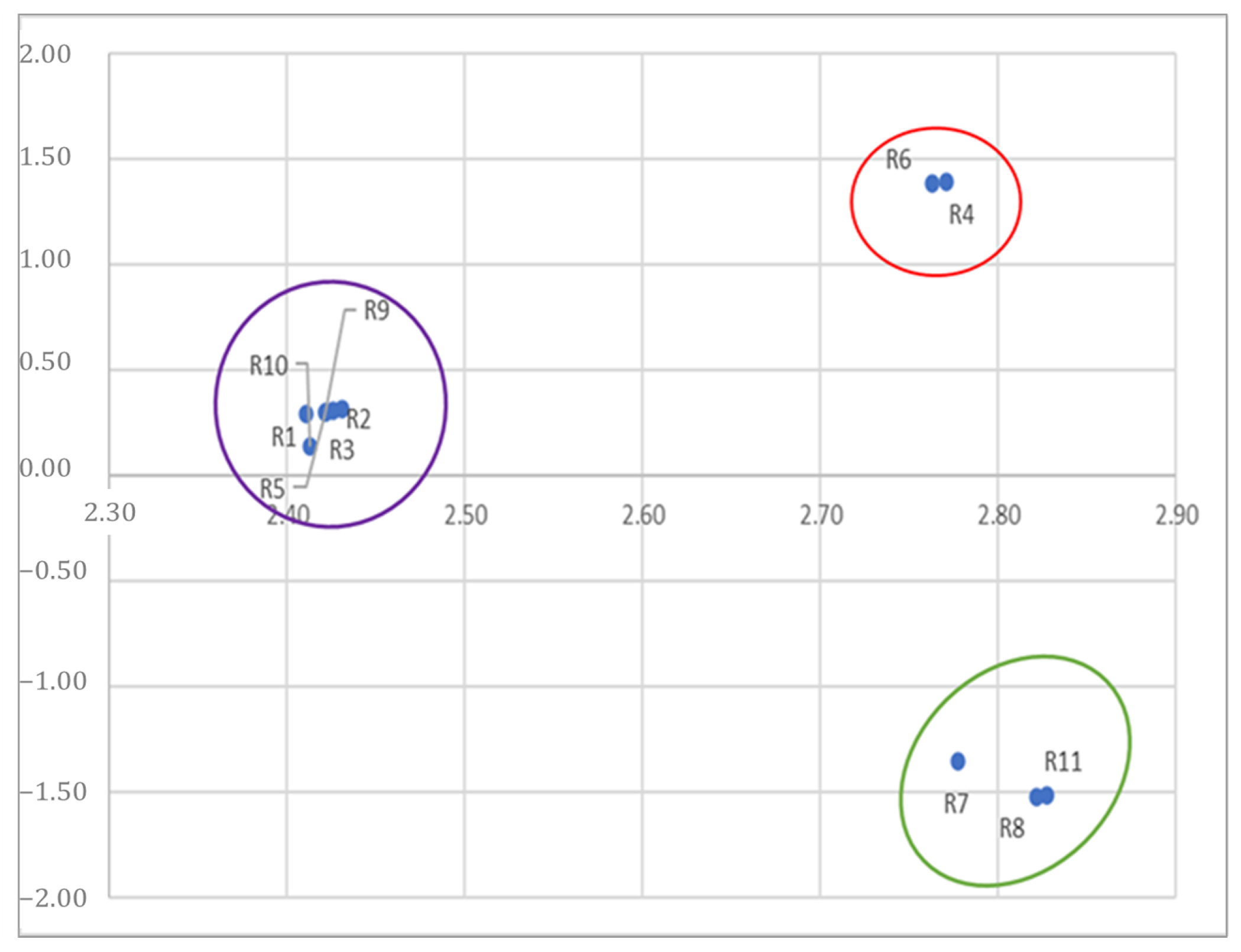
5.2.3. DEMATEL Analysis
6. Discussions, Inequalities and Research Gaps
7. Requirements for ITS in Africa
7.1. Challenges in African Transportation
- Economic and Political Challenges: Political disputes and civil unrest coupled with outdated and/or poorly implemented policies on transportation infrastructure are major challenges to ITS in Africa. In the African Development Bank Transport Forum’s report, it was noted that, among others issues, economic challenges translate to poor funding for road maintenance, while over-dependence on road transportation coupled with an increasing number of road users accelerates the wear and tear of roads. Aside from these, the unchecked population growth and corresponding increase in the number of private vehicles plying public roads is another challenge.
- Culture: Beyond economics, a certain cultural ethos in Africa also negatively impacts transportation. For instance, in Nigeria and many west African countries, cars are seen as symbols of social status. As such, an individual is considered “successful” if they own a car (or cars). This belief system fuels the desire to purchase more vehicles, thus increasing the number of road users and further exacerbating the challenges of road congestion.
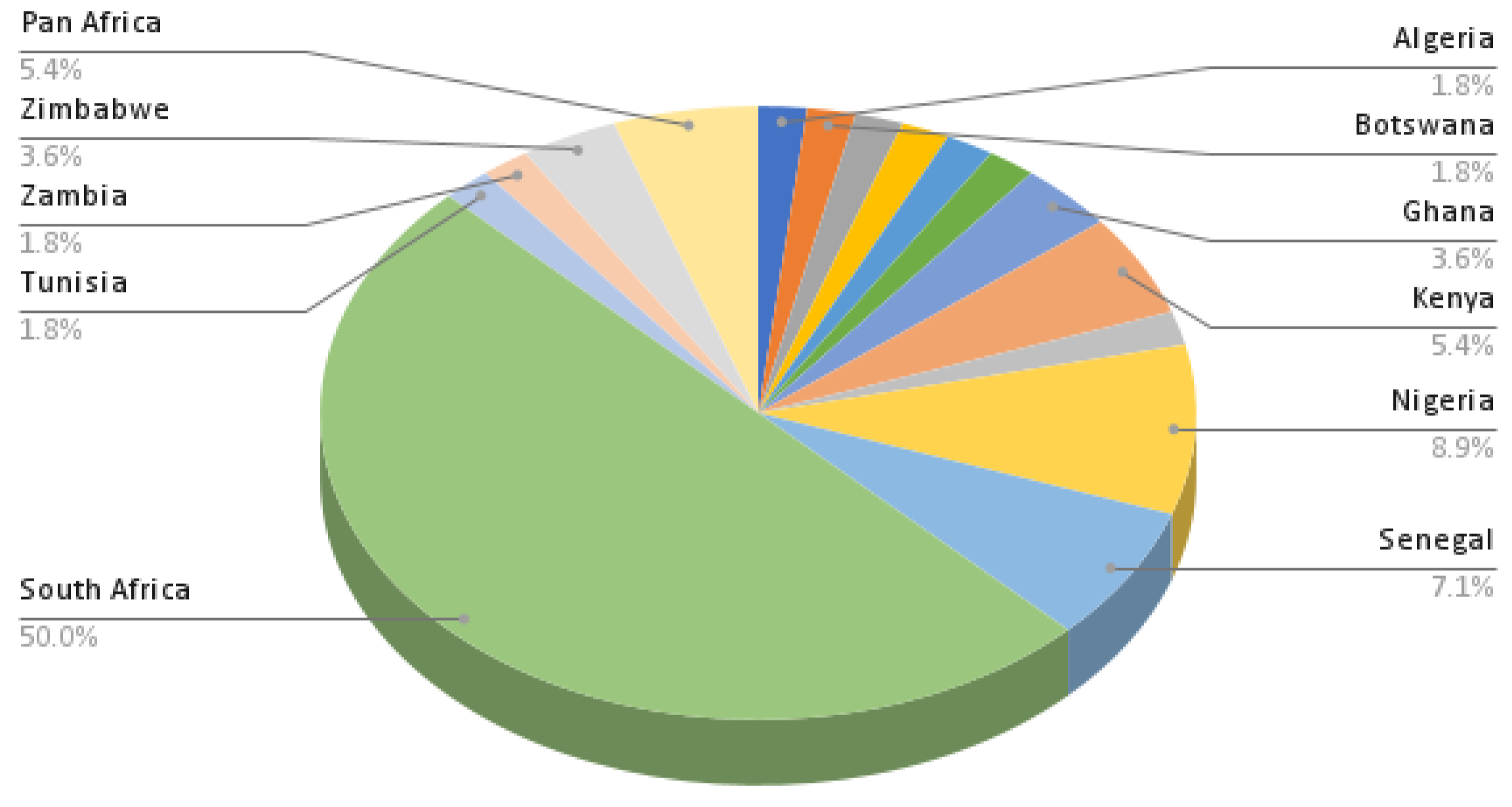
- Vehicle Types: Abuhamoud et al. [75] performed a historic survey of the developmental phases of transportation across African countries and also discussed the most prominent means of transportation in these countries. The work showed that, aside from trekking, motorcycles and bicycles were the prominent types of vehicles. This is not unrelated to the level of poverty and low purchasing power of citizenry. Numerous statistics also show that most of the vehicles plying African roads have previously been used in the Western world. These vehicles are then brought into African cities and remain in service for between 25 and 40 years.
- Ignored Alternatives: In most African countries, the road network is the most utilised means of transportation. As discussed in the previous section, despite the numerous rivers and other bodies of water running through the continent, water transportation is still largely ignored. Furthermore, rail transport, which is arguably one of earlier means of transportation in Africa, is also grossly under-utilised. Though rail tracks exist in many African cities, they are either old and dilapidated or ill-maintained and decommissioned. These are potential alternatives to the poorly maintained and over congested roads.
7.2. Viable Solutions
- Ride Sharing and Car Pooling: Many African countries are communal with a high level of social cooperation. Meals and houses are often shared among family members. This communal life style makes Africa ideal for ride sharing. Currently, across Africa, popular ride hailing services include Uber and Bolt (pan Africa), In-driver (in South Africa), Ousta, Careem and TaxiDiali (in North Africa) and Allo Taxi (in Central Africa). These services are often beyond the financial reach of the average citizens; hence, alternatives such as buses, three-wheeled Tuk-Tuks (motorised Rickshaws) and motorcycles are popular across African cities. Though ride sharing/pooling is being practiced in Africa, it is mostly informal and between friends or neighbours traveling towards the same destination. However, in recent years, with the proliferation of relatively cheap Android devices, formal car-pooling solutions such as Jumpin Rides in South Africa and Jekalo in Nigeria are beginning to emerge.
- Train and Railways: Railways are one of the earliest transportation media in Africa. With nearly 70,000 km of rail tracks across the continent and the capacity to transport large numbers of people and goods simultaneously, trains should be a very popular choice of transportation in Africa; however, this is not the case.Though train services are popular in countries such as South Africa (with the continent’s largest train network, at about 23,000 km) and Egypt (5500 km), as shown in Figure 12, their utilisation pales in comparison to transportation by roads. In Nigeria, for instance, despite having nearly 4000 km of railways, trains are grossly under-utilised.Train networks are well established in Europe, with an average passenger count of about 640 billion passengers annually [76]. This is in sharp contrast to Africa’s 22 billion, despite the fact that Africa has a larger population. Luckily, African governments have begun to realize this, and efforts are being put in place to improve railway transportation in Africa. Some of these projects include the African Union’s AUR, an organisation set up to interconnect railway lines across Africa. Similarly, a partnership between the African Union Development Agency and New Partnership for Africa’s Development (AUDA-NEPAD) is in place for the development of an integrated high-speed rail network, which is projected to interconnect landlocked countries, connect African regions and establish a Trans-Africa beltway by 2033. At a local level, there a number of metro-lines under construction in various countries. For instance, in Algeria, the Annaba, Mostaganem and Setif Tramways are under construction. Egypt has a number of Cairo metro lines being worked on, while in Tunisia, the Tunis Réseau Ferroviaire Rapide is being constructed. In Nigeria, the Lagos Rail Mass Transit, Abuja Light Rail and the Lagos–Kano railway are at different stages of construction. This is also the case with the Gautrain Expansion and Blue Downs Commuter services in South Africa [77,78].
- Water transportation: There are over 100 rivers and 7 lakes in Africa, and they can provide unique opportunities for water transportation across the continent. Though a number of water-based transportation methods are in operation, such as passenger and cargo freighting being operated across Lakes Malawi and Victoria in South-Eastern Africa, the Nile river in Egypt, Rivers Niger and Benue (Nigeria) and River Congo (DR Congo), African water transportation is still in its infancy. Rather than over-relying on road transportation, Africa can replicate some of the solutions that have been successfully implemented in European cities, such as Venice in Italy. In [79], the authors discussed a number of potential intra-continental water transportation channels, including a White Nile River–Lake Victoria channel, which would link Northern and Southern Africa; the Lake Tanzania–Congo River channel and the Zambezi River–Lake Malawi channel. Beyond these, cities such as Bukavu (DR Congo), Lagos and Port Harcourt (Nigeria) could benefit from water-based taxi/ferry services similar to those in Venice, Italy. Though these are potential solutions, the actualisation of these channels would require, among other things, major engineering works to dredge and interconnect these water bodies as well as cordial relationships and political agreements between the respective countries through which the channels would traverse.
- 5G and Data Ferrying Drones: Drone technology has emerged from a niche area, previously reserved for the American army, into a commodity technology used worldwide to provide different services in different environments. It has been reported that drones have been used in Rwanda and Malawi to support the transportation of HIV blood samples from isolated areas to laboratories in cities and towns. While still in the research phase, studies published in [80,81] have revealed that drones can be used to extend 5G support to rural and isolated areas where there are no incentives for telecommunication providers to deploy a 5G infrastructure. Furthermore, models of data ferrying have also been proposed in [82]. These models can be used in conjunction with IoT systems [83] to efficiently deploy drones for different purposes in the African context.
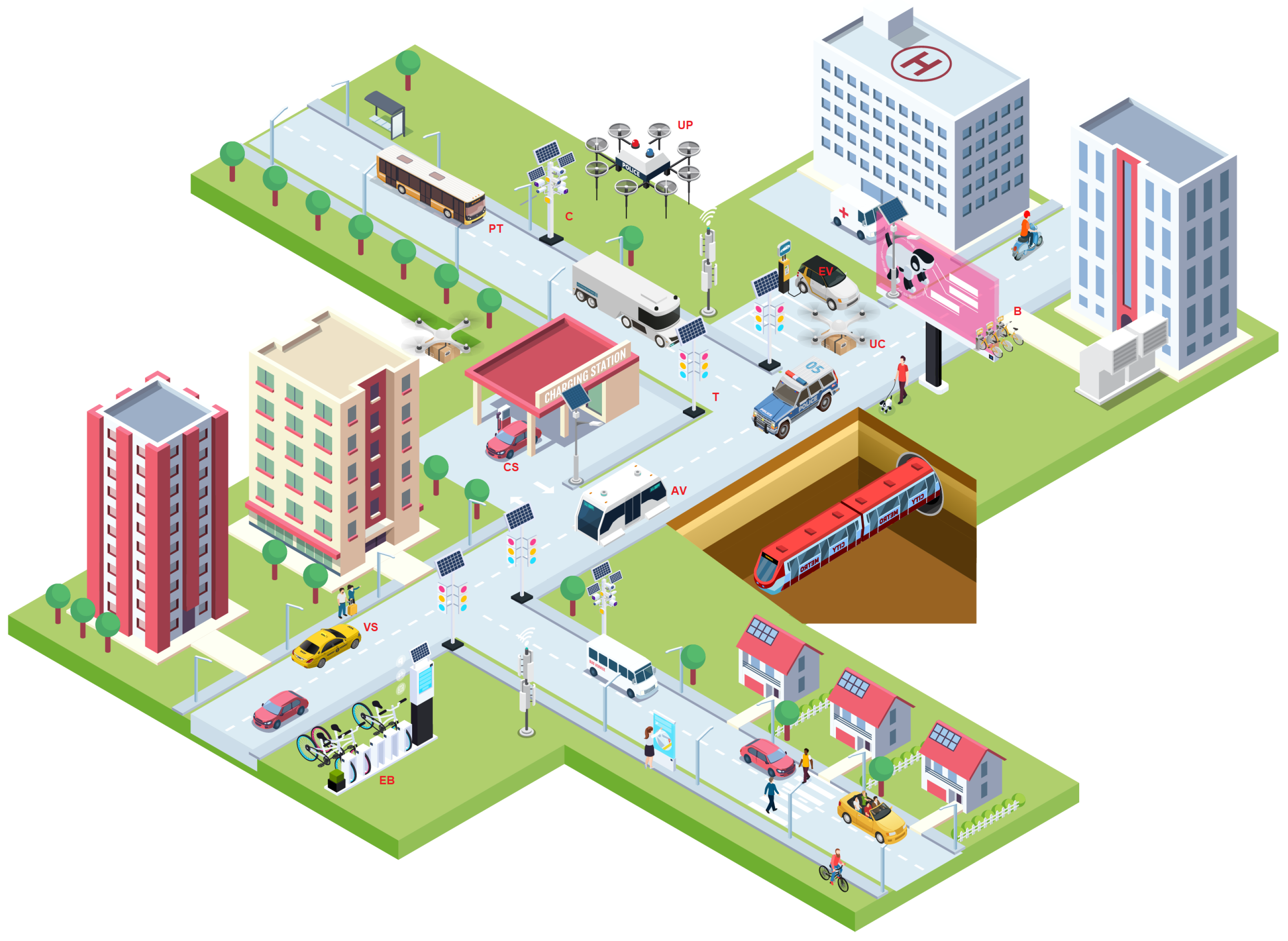
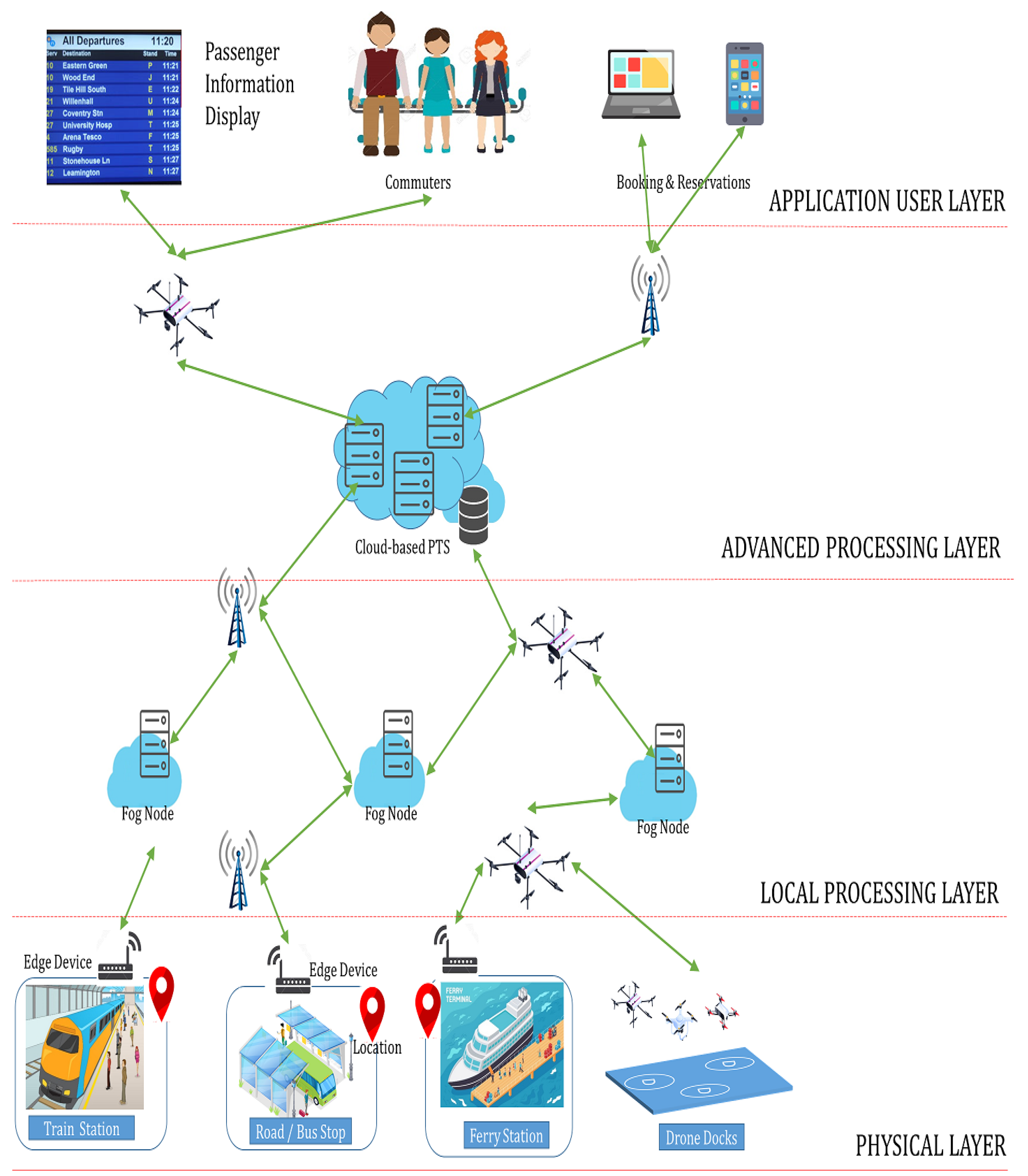
8. Proposed ITS Architecture for Africa
- Commuters: These are passengers who utilize the ITS. Passengers are able to plan their trips beforehand and select the transport medium that best suits their journey. Using their smart mobile phones or computers, tickets can be purchased online and seats booked. This booking system is provided by the cloud-based Passenger and Ticketing Management System (PTS).
- Passenger Information Displays (PID): These simply display information about the arrivals and departures of transport media, as well as relevant travel schedule information. The PID could be screens mounted around the stations and connected to the fog node or could be accessed through the commuters’ smart devices.
- Transport Media: These include railways (trains), waterways (ferries and boats) and road (cars, buses etc.). Each of these have a station/terminus where commuters embark and/or disembark.
- Location Sensors: GPS devices that monitor the locations of transport media in real-time.
- Edge Devices: These are installed at each station and actively monitor the ingress and egress of transport media. By communicating with the GPS sensors on each vehicle, the edge device can calculate the estimated arrival time, update travel schedules on the PID, send details to the fog nodes for local processing (or the cloud for advanced processing and storage) and onward dissemination to the commuters’ smart devices.
- Drones: These serve three roles: (i) as communication base stations, augmenting the traditional wireless cellular network towers, especially in remote locations (outside main cities); (ii) as surveillance systems in cases of accidents, faults or breakdowns, to locate the broken down trains/ferries/buses in remote location; and (iii) data ferries from sites of breakdowns to processing or control centres.
- Fog Nodes: These are small and distributed clouds located close to the end user. Their proximity reduces transmission latency, thus making them well suited for local and near real-time processing. They are responsible for updating the PID as well as on-site ticketing.
- Cloud-based Passenger and Ticketing Management System: A cloud-based solution that incorporates the following:
- Passenger ticket-issuing and managing commuter tickets and bookings;
- Schedule management, which provides information about travel schedules for the various transport media. Real-time information is received from the edge devices at each station or the fog nodes;
- Route planning—i.e., helping commuters plan their journeys by selecting the best combination of transportation media to travel from a source to destination.
With the proposed ITS architecture, an integrated system that encompasses multiple means of transportation can be achieved for the African continent.
9. Conclusions
Author Contributions
Funding
Institutional Review Board Statement
Informed Consent Statement
Conflicts of Interest
Appendix A

| Ref. | Country | Focus | Sub-Focus | Tool | Algorithm/Platform | Medium |
|---|---|---|---|---|---|---|
| [37] | Algeria | Infrastructure | Vehicle-Sensor-Networks | IoT and WSN | VANET | Road |
| [17] | Cameroon | Traffic control | Surveillance | Software simulations | Genetic Algorithm | Road |
| [31] | DRC | Traffic control | Congestion avoidance | Radar systems | Waterways | |
| [42] | Egypt | IoT in ITS | IoV opportunities and challenges | Review/Survey | ||
| [41] | Ethiopia | ITS development | ITS opportunities and challenges | Review/Survey | Road | |
| [22] | Ghana | Mobility | School buses | Review/Survey | Road | |
| [23] | Ghana | ITS development | ITS opportunities and challenges | Review/Survey | Road, Rail | |
| [39] | Kenya | Infrastructure | Data collection | Smart Phones | Road | |
| [46] | Kenya | Vehicle speed | Vehicle-2-Driver | Smart Phones | KNN, TTS | Road |
| [51] | Kenya | Vehicle insurance | Insurance | Smart Phones | Road | |
| [60] | Morocco | Road accidents | V2x Accident Prevention | IoT and WSN | Road | |
| [18] | Nigeria | Traffic control | Traffic lights | LED and Halogen Lamps | Road | |
| [4] | Nigeria | Traffic control | Traffic lights (TL) | Software simulations | Round-Robin | Road |
| [28] | Nigeria | Energy | Carbon emission | Software | LEAP | Road |
| [24] | Nigeria/South Africa | Logistics | Indoor carts | Multi-sensors | Warehouses | |
| [45] | Nigeria/South Africa | Traffic routing | Improving VANET | Software simulations | CSO + VANET, GA | Road |
| [32] | Senegal | ITS development | ITS and Economics | Review/Survey | ||
| [40] | Senegal | ICT in ITS | Review/Survey | |||
| [53] | Senegal | Infrastructure | Data collection | Smart Phones | Road | |
| [57] | Senegal | Mobility | Traffic Management | Smart Phones | Public Buses | Road |
| [16] | South Africa | Traffic control | Traffic lights | Review/Survey | Road | |
| [30] | South Africa | Traffic control | EV Preemption | Software simulations | Queuing Theory | Road |
| [33] | South Africa | Energy | Fuel consumption | Software simulations | Regression analysis | Road |
| [34] | South Africa | Energy | Fuel consumption | Software simulations | Empirical models | Road |
| [36] | South Africa | Energy | Fuel consumption | Software simulations | Empirical models | Road |
| [35] | South Africa | Fuel | Speed control | Software simulations | Maths models | Road |
| [19] | South Africa | Infrastructure | Autonomous vehicles | Review/Survey | Road | |
| [44] | South Africa | Security | Vehicle tracking | Cameras, Software | iFogSim | Road |
| [47] | South Africa | Vehicle speed | Vehicle-2-Driver | Multi-sensors | Audio alerts | Road |
| [67] | South Africa | Data muling | Vehicle as a data ferry | Raspberry Pi + ZigBee/WiFi | Road | |
| [48] | South Africa | ITS development | ITS opportunities and challenges | Review/Survey | Road | |
| [49] | South Africa/ Botswana | ICT in ITS | Review/Survey | Road | ||
| [50] | South Africa | IoT in ITS | IoV protocols | Software simulations | OMNET++ | Road |
| [52] | South Africa | Traffic control | TL preemption | Smart Phones | Road | |
| [54] | South Africa | ITS development | Fleet Management | IoT and WSN | Road | |
| [55] | South Africa/Zambia | Logistics | Food preservation | RFID | Regression Analysis | Road |
| [56] | South Africa | Mobility | Ride sharing | Smart Phones | Uber | Road |
| [62] | South Africa | Energy | EV penetration | Review/Survey | Road | |
| [27] | South Africa | Road accidents | Driving behaviours | Accelerometer | Road | |
| [58] | South Africa | Road accidents | Cost implication | Software simulations | Bayesian network | Road |
| [59] | South Africa | Road accidents | V2V, V2I Accident prevention | IoT and WSN | Road | |
| [64] | South Africa | ITS development | IoV opportunities and challenges | Software simulations | VANET | Road |
| [29] | South Africa | Drones | Path planning | Multi-sensors | Aerial | |
| [65] | South Africa | Traffic control | Improving VANET | Software simulations | VANET, DBSMA | Road |
| [66] | South Africa | Security | LPR | Raspberry Pi, Cameras | OpenALPR | Road |
| [26] | South Africa/Zimbabwe | Road accidents | Robot first aid: opportunities and Challenges | Review/Survey | Road | |
| [25] | Tunisia | Mobility | Ride sharing | Review/Survey | Road | |
| [43] | Zimbabwe | ITS development | Fleet Management | Software simulations | Krejcie and Morgan formula | Road |
| [20] | Africa | ITS development | ITS opportunities and challenges | Review/Survey | ||
| [63] | Africa | Energy | Carbon emission | Review/Survey | Road | |
| [61] | Africa | Road accidents | Drowsiness detection | Software simulations | GAN, CNN | Road |
References
- Wang, W.; Krishnan, R.; Diehl, A. Advances and Challenges in Intelligent Transportation: The Evolution of ICT to Address Transport Challenges in Developing Countries. Transport and ICT Connections, 2015, 26, World Bank. Available online: worldbank.org/en/topic/transport/.../connections-note-26 (accessed on 1 December 2020).
- Singh, B.; Gupta, A. Recent Trends in Intelligent Transportation Systems: A Review. J. Transp. Lit. 2014, 9, 30–34. [Google Scholar] [CrossRef]
- Wahab, N.; Seow, T.; Radzuan, I.; Mohamed, S. A Systematic Literature Review on The Dimensions of Smart Cities. IOP Conf. Ser. Earth Environ. Sci. 2020, 498, 012087. [Google Scholar] [CrossRef]
- Ajayi, O.; Bagula, A.; Isafiade, O.; Noutouglo, A. Effective Management of Delays at Road Intersections Using Smart Traffic Light System. In Proceedings of the International Conference on e-Infrastructure and e-Services for Developing Countries, Porto-Novo, Benin, 3–4 December 2019; Springer: Cham, Switzerland, 2019; pp. 84–103. [Google Scholar]
- Bagula, A.; Castelli, L.; Zennaro, M. On the design of smart parking networks in the smart cities: An optimal sensor placement model. Sensors 2015, 15, 15443–15467. [Google Scholar] [CrossRef]
- Wirasinghe, S.C.; Kattan, L.; Rahman, M.M.; Hubbell, J.; Thilakaratne, R.; Anowar, S. Bus rapid transit—A review. Int. J. Urban Sci. 2013, 17, 1–31. [Google Scholar] [CrossRef]
- Adeniran, A. Idea of Smart Development in the Fourth Industrial Revolution Emphasis on Smart Road. SF J. Telecommun. 2017, 1, 1–6. [Google Scholar]
- Cledou, G.; Estevez, E.; Barbosa, L. A taxonomy for planning and designing smart mobility services. Gov. Inf. Q. 2018, 35, 61–76. [Google Scholar] [CrossRef]
- Behruz, H.; Chavoshy, A.P.; Mozaffari, G. Challenges of implementation of intelligent transportation systems in developing countries: Case study–Tehran. WIT Trans. Ecol. Environ. 2013, 179, 977–987. [Google Scholar]
- Ameen, H.A.; Zaidan, B.B.; Zaidan, A.A.; Saon, S.; Nor, D.M.; Malik, R.Q.; Kareem, Z.H.; Garfan, S.; Zaidan, R.A.; Mohammed, A. A Deep Review and Analysis of Data Exchange in Vehicle-to-Vehicle Communications Systems: Coherent Taxonomy, Challenges, Motivations, Recommendations, Substantial Analysis and Future Directions. IEEE Access 2019, 7, 158349–158378. [Google Scholar] [CrossRef]
- Tan, S.; Taeihagh, A. Smart city governance in developing countries: A systematic literature review. Sustainability 2020, 12, 899. [Google Scholar] [CrossRef]
- Winkowska, J.; Szpilko, D.; Pejić, S. Smart city concept in the light of the literature review. Eng. Manag. Prod. Serv. 2019, 11, 70–86. [Google Scholar] [CrossRef]
- Adeniran, A. Impacts of the Fourth Industrial Revolution on Transportation in the Developing Nations. IESRJ 2016, 2, 56–60. [Google Scholar]
- Cisse, Y.; Pambuka, N. Adapting First World Systems to Improve African Mobility. Intelligent Transport. 2020. Available online: https://www.intelligenttransport.com/transport-articles/95942/adapting-first-world-systems-to-improve-african-mobility/ (accessed on 1 December 2020).
- Middleton, L. Freedom to Move: Transportation in African Cities. AURI Policy Brief 6, 2018; p. 13. Available online: https://www.urbanafrica.net/wp-content/uploads.../Mobility_ENG.pdf (accessed on 5 December 2020).
- Olayode, I.; Tartibu, L.; Okwu, M.; Uchechi, U. Intelligent transportation systems, un-signalized road intersections and traffic congestion in Johannesburg: A systematic review. Procedia CIRP 2020, 91, 844–850. [Google Scholar] [CrossRef]
- Mfenjou, M.; Ari, A.; Njoya, A.N.; Mbogne, D.; Abdou, W.; Spies, F. Control Points Deployment in an Intelligent Transportation System for MONITORING Inter-Urban Network Roadway; J. King Saud University-Computer and Information Sciences; Elsevier: Amsterdam, The Netherlands, 2019. [Google Scholar]
- Osigbemeh, M.; Onuu, M.; Asaolu, O. Design and development of an improved traffic light control system using hybrid lighting system. J. Traffic Transp. Eng. Engl. Ed. 2017, 4, 88–95. [Google Scholar] [CrossRef]
- Wyn, J.; Maina, J.W. Guidelines for the use of accelerated pavement testing data in autonomous vehicle infrastructure research. J. Traffic Transp. Eng. Engl. Ed. 2019, 6, 273–281. [Google Scholar]
- Mfenjou, M.L.; Ari, A.A.; Abdou, W.; Spies, F. Methodology and trends for an intelligent transport system in developing countries. Sustain. Comput. Informatics Syst. 2018, 19, 96–111. [Google Scholar] [CrossRef]
- Saidi, S.; Mani, V.; Mefteh, H.; Shahbaz, M.; Akhtar, P. Dynamic linkages between transport, logistics, foreign direct Investment, and economic growth: Empirical evidence from developing countries. Transp. Res. Part A Policy Pract. 2020, 141, 277–293. [Google Scholar] [CrossRef]
- Agyeman, S.; Cheng, L. Analysis of barriers to perceived service quality in Ghana: Students’ perspectives on bus mobility attributes. Transp. Policy 2020, 99, 63–85. [Google Scholar] [CrossRef]
- Okyere, D.K.; Poku-Boansi, M.; Adarkwa, K.K. Connecting the dots: The nexus between transport and telecommunication in Ghana. Telecommun. Policy 2018, 42, 836–844. [Google Scholar] [CrossRef]
- Oyejide, O.J.; Okwu, M.O.; Tartibu, L.K.; Olayode, O.I. Development of Sensor Controlled Convertible Cart-Trolley. Procedia CIRP 2020, 91, 71–79. [Google Scholar] [CrossRef]
- Kilian-Yasin, K.; Wöhr, M.; Tangour, C.; Fournier, G. Social acceptance of alternative mobility systems in Tunis. Transp. Res. Procedia 2016, 19, 135–146. [Google Scholar] [CrossRef]
- Kurebwa, J.G.; Mushiri, T. Passenger car safety and emergency healthcare: A literature review. Procedia Manuf. 2019, 35, 35–49. [Google Scholar] [CrossRef]
- Joubert, J.W.; De Beer, D.; De Koker, N. Combining accelerometer data and contextual variables to evaluate the risk of driver behaviour. Transp. Res. Part F: Traffic Psychol. Behav. 2016, 41, 80–96. [Google Scholar] [CrossRef]
- Maduekwe, M.; Akpan, U.; Isihak, S. Road transport energy consumption and vehicular emissions in Lagos, Nigeria: An application of the LEAP model. Transp. Res. Interdiscip. Perspect. 2020, 6, 100172. [Google Scholar] [CrossRef]
- Fouche, G.J.; Malekian, R. Drone as an autonomous aerial sensor system for motion planning. Measurement 2018, 119, 142–155. [Google Scholar] [CrossRef]
- Ajayi, O.; Bagula, A.; Chukwubueze, I.; Maluleke, H. Priority Based Traffic Pre-emption System for Medical Emergency Vehicles in Smart Cities. In Proceedings of the 2020 IEEE Symposium on Computers and Communications (ISCC), Rennes, France, 7 July 2020; pp. 1–7. [Google Scholar]
- Adediji, O.A.; Alomari, M.K. Successful implementation of radar monitoring system and increased intelligence capacity on Congo River. In Proceedings of the 2018 7th International Conference on Industrial Technology and Management (ICITM), Oxford, UK, 7–9 March 2018; pp. 362–366. [Google Scholar] [CrossRef]
- Mboup, G. Creating Digital, Smart Cities for Smart Economies: From Big Cities to Digital Urban Centers. In Smart Economy in Smart Cities 2017; Springer: Singapore, 2017; pp. 931–948. [Google Scholar]
- Hoffman, A.J.; van der Westhuizen, M. Empirical model for truck route fuel economy. In Proceedings of the 2019 IEEE Intelligent Transportation Systems Conference (ITSC), Auckland, New Zealand, 27 October 2019; pp. 914–919. [Google Scholar]
- Hoffman, A.J.; van der Westhuizen, M. An empirical model for the assessment of truck driver fuel economy. In Proceedings of the 2019 IEEE Intelligent Transportation Systems Conference (ITSC), Auckland, New Zealand, 27 October 2019; pp. 637–642. [Google Scholar]
- Akpa, N.E.; Booysen, M.J.; Sinclair, M. Fuel savings as an incentive for speed compliance in the informal public transport industry in South Africa. In Proceedings of the 2019 IEEE Intelligent Transportation Systems Conference (ITSC), Auckland, New Zealand, 27 October 2019; pp. 492–496. [Google Scholar]
- Hoffman, A.J. Quantifying the impact of freight transport performance on the total economic cost of cargo importers. In Proceedings of the 2019 IEEE Intelligent Transportation Systems Conference (ITSC), Auckland, New Zealand, 27 October 2019; pp. 649–654. [Google Scholar]
- Bellaouar, S.; Guerroumi, M.; Derhab, A.; Moussaoui, S. Towards Heterogeneous Architectures of Hybrid Vehicular Sensor Networks for Smart Cities. In Smart Cities 2018; Springer: Cham, Switzerland, 2018; pp. 51–70. [Google Scholar]
- Chakwizira, J. The Intersection of Spatial Fragmentation and Smart Transport Planning in Gauteng Province, South Africa: Constraints and Opportunities. In Advances in Human Aspects of Transportation. AHFE 2020. Advances in Intelligent Systems and Computing; Stanton, N., Ed.; Springer: Cham, Switzerland, 2020; Volume 1212. [Google Scholar] [CrossRef]
- Wamburu, J.; Kaguma, D.; Tatsubori, M.; Walcott-Bryant, A.; Bryant, R.E.; Weldemariam, K. Roaming Nairobi roads: Instrumenting roads under resource constraints. In Proceedings of the 2017 IEEE/ACM 4th International Conference on Mobile Software Engineering and Systems (MOBILESoft), Buenos Aires, Argentina, 22 May 2017; pp. 100–109. [Google Scholar]
- Mboup, G. Smart infrastructure development makes smart cities—Promoting smart transport and ICT in Dakar. In Smart Economy in Smart Cities 2017; Springer: Singapore, 2017; pp. 871–904. [Google Scholar]
- Bireda, T. Intelligent Transport System in Ethiopia: Status and the Way Forward. In International Conference on Information and Communication Technology for Development for Africa 25 September 2017; Springer: Cham, Switzerland, 2017; pp. 34–45. [Google Scholar]
- Adly, A.S. Integrating Vehicular Technologies within the IoT Environment: A Case of Egypt. In Connected Vehicles in the Internet of Things 2020; Springer: Cham, Switzerland, 2020; pp. 85–100. [Google Scholar]
- Muchaendepi, W.; Mbohwa, C.; Kanyepe, J. Intelligent Transport Systems and its Impact on Performance of Road Freight Transport in Zimbabwe. In Proceedings of the 2018 IEEE International Conference on Industrial Engineering and Engineering Management (IEEM), Bangkok, Thailand, 16 December 2018; pp. 80–83. [Google Scholar]
- Sinqadu, M.; Shibeshi, Z.S. Performance Evaluation of a Traffic Surveillance Application Using iFogSim. In International Conference on Wireless Intelligent and Distributed Environment for Communication 6 May 2020; Springer: Cham, Switzerland, 2020; pp. 51–64. [Google Scholar]
- Bello-Salau, H.; Onumanyi, A.J.; Abu-Mahfouz, A.M.; Adejo, A.O.; Mu’Azu, M.B. New discrete cuckoo search optimization algorithms for effective route discovery in IoT-based vehicular ad-hoc networks. IEEE Access 2020, 8, 145469–145488. [Google Scholar] [CrossRef]
- Obuhuma, J.; Okoyo, H.; Mcoyowo, S. Real-time Driver Advisory Model: Intelligent Transportation Systems. In Proceedings of the 2018 IST-Africa Week Conference (IST-Africa), Gabarone, Botswana, 9 May 2018; p. 1. [Google Scholar]
- Akpa, N.E.; Booysen, M.J.; Sinclair, M. Auditory intelligent speed adaptation for long-distance informal public transport in South Africa. IEEE Intell. Transp. Syst. Mag. 2016, 8, 53–64. [Google Scholar] [CrossRef]
- Bashingi, N.; Hassan, M.M.; Masinde, M. Possible Challenges of Integrating ICTs into the Public Transportation System in the Free State Province, South Africa. In Proceedings of the International Conference on e-Infrastructure and e-Services for Developing Countries, Cotonou, Benin, 15 December 2015; Springer: Cham, Switzerland, 2015; pp. 66–69. [Google Scholar]
- Bashingi, N.; Hassan, M.M.; Das, D.K. Information Communication Technologies for Travel in Southern African Cities. In Proceedings of the International Congress and Exhibition Sustainable Civil Infrastructures, Cairo, Egypt, 10 November 2019; Springer: Cham, Switzerland, 2019; pp. 114–127. [Google Scholar]
- Thakur, A.; Malekian, R. Internet of vehicles communication technologies for traffic management and road safety applications. Wirel. Pers. Commun. 2019, 109, 31–49. [Google Scholar] [CrossRef]
- Walcott-Bryant, A.; Tatsubori, M.; Bryant, R.E.; Oduor, E.; Omondi, S.; Osebe, S.; Wamburu, J.; Bent, O. Harsh brakes at potholes in Nairobi: Context-based driver behavior in developing cities. In Proceedings of the 2016 IEEE 19th International Conference on Intelligent Transportation Systems (ITSC), Rio de Janeiro, Brazil, 1 November 2016; pp. 675–681. [Google Scholar]
- Madisa, M.K.; Joseph, M.K. Android and Cloud Based Traffic Control System. In Proceedings of the 2018 International Conference on Advances in Big Data, Computing and Data Communication Systems (icABCD), Durban, South Africa, 6 August 2018; pp. 1–4. [Google Scholar]
- Wang, Y.; Correia, G.; de Romph, E.; Santos, B.F. Road Network Design in a Developing Country Using Mobile Phone Data: An Application to Senegal. IEEE Intell. Transport. Syst. Mag. 2020, 12, 36–49. [Google Scholar] [CrossRef]
- Masinde, M.; Shoman, A.; Mostafa, M.H. Internet of Things-Based Framework for Public Transportation Fleet Management in Non-smart City. In Proceedings of the International Conference on Emerging Technologies for Developing Countries, Cotonou, Benin, 29 May 2018; Springer: Cham, Switzerland, 2018; pp. 3–17. [Google Scholar]
- Emenike, C.C.; Van Eyk, N.P.; Hoffman, A.J. Improving cold chain logistics through RFID temperature sensing and predictive modelling. In Proceedings of the 2016 IEEE 19th International Conference on Intelligent Transportation Systems (ITSC), Rio de Janeiro, Brazil, 1 November 2016; pp. 2331–2338. [Google Scholar]
- Giddy, J.K. Travel Patterns of Uber Users in South Africa. In New Directions in South African Tourism Geographies 2020; Springer: Cham, Switzerland, 2020; pp. 113–127. [Google Scholar]
- Demissie, M.G.; Phithakkitnukoon, S.; Sukhvibul, T.; Antunes, F.; Gomes, R.; Bento, C. Inferring passenger travel demand to improve urban mobility in developing countries using cell phone data: A case study of Senegal. IEEE Trans. Intell. Transp. Syst. 2016, 17, 2466–2478. [Google Scholar] [CrossRef]
- Makaba, T.; Doorsamy, W.; Paul, B.S. Bayesian Network-Based Framework for Cost-Implication Assessment of Road Traffic Collisions. Int. J. Intell. Transp. Syst. Res. 2020, 14, 1–4. [Google Scholar] [CrossRef]
- Thakur, A.; Malekian, R.; Bogatinoska, D.C. Internet of things based solutions for road safety and traffic management in intelligent transportation systems. In Proceedings of the International Conference on ICT Innovations, Skopje, Macedonia, 18 September 2017; Springer: Cham, Switzerland, 2017; pp. 47–56. [Google Scholar]
- Sabir, Z.; Dafrallah, S.; Amine, A. A Novel Solution to Prevent Accidents using V2I in Moroccan Smart Cities. In Proceedings of the 2019 International Conference on Computational Intelligence and Knowledge Economy (ICCIKE), Dubai, United Arab Emirates, 11 December 2019; pp. 621–625. [Google Scholar]
- Ngxande, M.; Tapamo, J.R.; Burke, M. Bias Remediation in Driver Drowsiness Detection Systems Using Generative Adversarial Networks. IEEE Access 2020, 8, 55592–55601. [Google Scholar] [CrossRef]
- Pillay, N.S.; Brent, A.C.; Musango, J.K. Control Theory and System Dynamics Simulations of Electric Vehicle Market Penetration in South Africa. In Proceedings of the International Conference on Emerging Trends in Electrical, Electronic and Communications Engineering, Bagatelle, Mauritius, 28 November 2018; Springer: Cham, Switzerland, 2018; pp. 403–413. [Google Scholar]
- Nalule, V.R. Transitioning to a Low Carbon Economy: Is Africa Ready to Bid Farewell to Fossil Fuels? In The Palgrave Handbook of Managing Fossil Fuels and Energy Transitions 2020; Palgrave Macmillan: Cham, Switzerland, 2020; pp. 261–286. [Google Scholar]
- Moloisane, N.R.; Malekian, R.; Bogatinoska, D.C. Wireless machine-to-machine communication for intelligent transportation systems: Internet of Vehicles and Vehicle to Grid. In Proceedings of the 2017 40th International Convention on Information and Communication Technology, Electronics and Microelectronics (MIPRO), Opatija, Croatia, 22 May 2017; pp. 411–415. [Google Scholar]
- Feukeu, E.A.; Ngwira, S.M. Congestion mitigation in a vehicular network using DBSMA. In Proceedings of the 2016 International Conference on Advances in Computing and Communication Engineering (ICACCE), Durban, South Africa, 28 November 2016; pp. 91–95. [Google Scholar]
- Rademeyer, M.C.; Barnard, A.; Booysen, M.J. Optoelectronic and Environmental Factors Affecting the Accuracy of Crowd-Sourced Vehicle-Mounted License Plate Recognition. IEEE Open J. Intell. Transp. Syst. 2020, 1, 15–28. [Google Scholar] [CrossRef]
- Ngu, K.G.; Ouahada, K.; Rimer, S. Using Mini-Bus Taxis as Data Mules. In Proceedings of the 2018 IEEE 7th International Conference on Adaptive Science & Technology (ICAST), Accra, Ghana, 22 August 2018; pp. 1–7. [Google Scholar]
- Saaty, T.L. The Analytic Hierarchy Process: Planning, Priority Setting, Resource Allocation; McGrew-Hill: New York, NY, USA, 1980. [Google Scholar]
- Fontela, E.; Gabus, A. The DEMATEL Observer, DEMATEL 1976 Report; Battelle Geneva Research Center: Geneva, Switzerland, 1976. [Google Scholar]
- Wu, W.W.; Lee, Y.T. Developing global managers’ competencies using the fuzzy DEMATEL method. Expert Syst. Appl. 2007, 32, 499–507. [Google Scholar] [CrossRef]
- Aung, T.S.; Luan, S.; Xu, Q. Application of multi-criteria-decision approach for the analysis of medical waste management systems in Myanmar. J. Clean. Prod. 2019, 222, 733–745. [Google Scholar] [CrossRef]
- Lin, R.J. Using fuzzy DEMATEL to evaluate the green supply chain management practices. J. Clean. Prod. 2013, 40, 32–39. [Google Scholar] [CrossRef]
- Islam, M.S.; Tseng, M.L.; Karia, N. Assessment of corporate culture in sustainability performance using a hierarchical framework and interdependence relations. J. Clean. Prod. 2019, 217, 676–690. [Google Scholar] [CrossRef]
- Liu, H.C.; You, J.X.; Lu, C.; Chen, Y.Z. Evaluating health-care waste treatment technologies using a hybrid multi-criteria decision making model. Renew. Sustain. Energy Rev. 2015, 41, 932–942. [Google Scholar] [CrossRef]
- Abuhamoud, M.A.; Rahmat, R.A.; Ismail, A. Transportation and its concerns in Africa: A review. Soc. Sci. 2011, 6, 51–63. [Google Scholar] [CrossRef][Green Version]
- Statista. Rail Passenger Traffic in Europe from 2012 to 2019 (in Billion Passenger Kilometers). Available online: www.statista.com/statistics/1104588/rail-passenger-traffic-europe/statisticContainer (accessed on 20 February 2021).
- Statista. Africa: Upcoming Urban Rail Projects. 2016. Available online: www.globalmasstransit.net (accessed on 20 February 2021).
- Yakubu, D. FG Kicks-Off Lagos-Kano Railway Project. Vanguard News Nigeria. 2020. Available online: https://www.vanguardngr.com/2020/07/fg-kicks-off-lagos-kano-railway-project/ (accessed on 20 February 2021).
- Valentine, H. A Trans-Africa Inland Waterway System? The Maritime Executive. 2016. Available online: www.maritime-executive.com/editorials/a-trans-africa-inland-waterway-system (accessed on 20 February 2021).
- Chiaraviglio, L.; Blefari-Melazzi, N.; Liu, W.; Gutiérrez, J.A.; Van De Beek, J.; Birke, R.; Chen, L.; Idzikowski, F.; Kilper, D.; Monti, P.; et al. Bringing 5G in Rural and Low-Income Areas: Is it Feasible? IEEE Commun. Stand. Mag. 2017, 1, 50–57. [Google Scholar] [CrossRef]
- Maluleke, H.; Bagula, A.; Ajayi, O. Efficient Airborne Network Clustering for 5G Backhauling and Fronthauling. In Proceedings of the 2020 16th International Conference on Wireless and Mobile Computing, Networking and Communications (WiMob) (50308), Thessaloniki, Greece, 12–14 October 2020; pp. 99–104. [Google Scholar]
- Tuyishimire, E.; Bagula, A.; Rekhis, S.; Boudriga, N. Cooperative data muling from ground sensors to base stations using UAVs. In Proceedings of the IEEE Symposium on Computers and Communications (ISCC), Heraklion, Greece, 3–6 July 2017; pp. 35–41. [Google Scholar]
- Miazi, M.N.S.; Erasmus, Z.; Razzaque, M.A.; Zennaro, M.; Bagula, A. Enabling the Internet of Things in developing countries: Opportunities and challenges. In Proceedings of the 5th IEEE International Conference on Informatics, Electronics and Vision (ICIEV), Dhaka, Bangladesh, 13–14 May 2016; pp. 564–569. [Google Scholar]


| Component | Description |
|---|---|
| Transport Monitoring and Tracking systems | Monitoring and tracking of vehicles, roads and traffic conditions to provide real-time and on-demand traffic information. Cameras are essential and form a critical part of surveillance systems, license plate recognition and other forms of vehicle/road-related security concerns. |
| Bus Rapid Transit | A transportation system composed of dedicated road network and buses aimed at providing quality public transit service using limited infrastructure, relatively low capital outlay and minimal cost of operating [6]. |
| Vehicle-as-a-service (VAAS), Car Pooling and Smart Mobility | Provision of real-time, on-demand, multi-modal public transportation options for passengers. VAAS differs from car-pooling in that it incorporates multiple means of transport and offers options such as vehicle leasing and long term rental. Instead of owning vehicles, passengers can simply pay a monthly or weekly fee to have access to vehicles anytime. This eliminates maintenance cost, insurance, registration and other costs associated with vehicle ownership. |
| Smart Traffic Control | These are adaptive traffic control systems that seek to make informed decisions based on real-time traffic conditions [4]. Their “smartness” is achieved by using a combination of sensors (infrared, ultra-sonic and/or cameras) and machine learning algorithms. |
| Smart Roads | These are roads that think, feel and can predict the needs of users with the primary aim of improving safety [7]. Sensors are built into these roads, which enable them gather data about various conditions and communicate the data to road users. Some noted characteristics of smart roads include route optimisation (by interacting with road users to avoid or reduce congestion), economic viability (with respect to design, construction, maintenance and operation) and safety consciousness. |
| Self-driving and Electric cars | Electric vehicles are vehicles with an electric-based propulsion system. They can be pure electric or a hybrid combination of an internal combustion engine (ICE) and batteries. EVs are designed with the ultimate goal of reducing the carbon emissions of ICEs. |
| Interactive | Multi-directional flow of information between road users, vehicles, traffic management authorities and/or systems. An example might be the use of sensors within smartphones to automatically assess road conditions and passenger comfort level while in transit and transmitting same to regulatory authorities, as described in [1]. |
| Drone/UAV-based Courier | Application of drones (autonomous or controlled) in the transportation of goods such as medical supplies, food and mails. |
| AFRICA | ASIA | EUROPE | |||||||||||
|---|---|---|---|---|---|---|---|---|---|---|---|---|---|
| Research Focus | Elsevier | Ref. | Springer | Ref. | IEEE | Ref. | Elsevier | Springer | IEEE | Elsevier | Springer | IEEE | |
| 1 | Monitoring and Control (MC) | 3 | [16,17,18] | 1 | [4] | 2 | [30,31] | 4 | 2 | 8 | 15 | 4 | 4 |
| 2 | Economic Impact (EI) | 1 | [32] | 4 | [33,34,35,36] | 12 | 6 | 2 | 19 | 17 | 5 | ||
| 3 | Planning & Infrastructure (PI) | 1 | [19] | 2 | [37,38] | 1 | [39] | 3 | 5 | 5 | 23 | 24 | 16 |
| 4 | Surveys (SV) | 3 | [20,21,22] | 4 | [38,40,41,42] | 1 | [43] | 13 | 11 | 2 | 34 | 26 | 15 |
| 5 | Big Data, ML, Analytics & Cloud (BMAC) | 1 | [44] | 3 | [45,46,47] | 10 | 9 | 4 | 22 | 18 | 9 | ||
| 6 | Role of ICT & Smart Phones (ISP) | 1 | [23] | 3 | [48,49,50] | 3 | [51,52,53] | 9 | 7 | 10 | 32 | 31 | 7 |
| 7 | Supply Chain /Logistics (SL) | 1 | [24] | 1 | [54] | 1 | [55] | 7 | 10 | 0 | 22 | 11 | 1 |
| 8 | Ride Hailing, Smart/Dynamic Mobility (RM) | 1 | [25] | 1 | [56] | 1 | [57] | 5 | 6 | 2 | 8 | 4 | 0 |
| 9 | Health & Safety (HS) | 2 | [26,27] | 2 | [58,59] | 2 | [60,61] | 9 | 8 | 3 | 33 | 14 | 8 |
| 10 | Energy (EN) | 1 | [28] | 2 | [62,63] | 1 | [64] | 8 | 3 | 4 | 17 | 4 | 17 |
| 11 | UAVs, Security, etc. (Others) | 1 | [29] | 1 | [65] | 1 | [66] | 9 | 1 | 11 | 23 | 19 | 1 |
| Linguistic Variables | Numeric | TFN (l,m,u) |
|---|---|---|
| NE (Non-Existent) | 0 | 0,0,1 |
| LR (Low/Rare) | 2 | 1,2,3 |
| FC (Fairly Common) | 4 | 3,4,5 |
| VC (Very Common) | 6 | 5,6,6 |
| R1 | R2 | R3 | R4 | R5 | R6 | R7 | R8 | R9 | R10 | R11 | Criteria | ||
|---|---|---|---|---|---|---|---|---|---|---|---|---|---|
| 6 | 5 | 4 | 8 | 4 | 7 | 3 | 3 | 6 | 4 | 3 | Weights | ||
| R1 | 6 | 0.113 | 0.113 | 0.113 | 0.113 | 0.113 | 0.113 | 0.113 | 0.113 | 0.113 | 0.113 | 0.113 | 0.11 |
| R2 | 5 | 0.094 | 0.094 | 0.094 | 0.094 | 0.094 | 0.094 | 0.094 | 0.094 | 0.094 | 0.094 | 0.094 | 0.09 |
| R3 | 4 | 0.075 | 0.075 | 0.075 | 0.075 | 0.075 | 0.075 | 0.075 | 0.075 | 0.075 | 0.075 | 0.075 | 0.08 |
| R4 | 8 | 0.151 | 0.151 | 0.151 | 0.151 | 0.151 | 0.151 | 0.151 | 0.151 | 0.151 | 0.151 | 0.151 | 0.15 |
| R5 | 4 | 0.075 | 0.075 | 0.075 | 0.075 | 0.075 | 0.075 | 0.075 | 0.075 | 0.075 | 0.075 | 0.075 | 0.08 |
| R6 | 7 | 0.132 | 0.132 | 0.132 | 0.132 | 0.132 | 0.132 | 0.132 | 0.132 | 0.132 | 0.132 | 0.132 | 0.13 |
| R7 | 3 | 0.057 | 0.057 | 0.057 | 0.057 | 0.057 | 0.057 | 0.057 | 0.057 | 0.057 | 0.057 | 0.057 | 0.06 |
| R8 | 3 | 0.057 | 0.057 | 0.057 | 0.057 | 0.057 | 0.057 | 0.057 | 0.057 | 0.057 | 0.057 | 0.057 | 0.06 |
| R9 | 6 | 0.113 | 0.113 | 0.113 | 0.113 | 0.113 | 0.113 | 0.113 | 0.113 | 0.113 | 0.113 | 0.113 | 0.11 |
| R10 | 4 | 0.075 | 0.075 | 0.075 | 0.075 | 0.075 | 0.075 | 0.075 | 0.075 | 0.075 | 0.075 | 0.075 | 0.08 |
| R11 | 3 | 0.057 | 0.057 | 0.057 | 0.057 | 0.057 | 0.057 | 0.057 | 0.057 | 0.057 | 0.057 | 0.057 | 0.06 |
| Research Sub-Domain | Scaled Criteria Weight (SCW) | Numeric Mapping | Linguistic Variable |
|---|---|---|---|
| R1 | 2.264 | 2 | LR |
| R2 | 1.887 | 2 | LR |
| R3 | 1.509 | 2 | LR |
| R4 | 3.019 | 3 | FC |
| R5 | 1.509 | 2 | LR |
| R6 | 2.642 | 3 | FC |
| R7 | 1.132 | 1 | LR |
| R8 | 1.132 | 1 | LR |
| R9 | 2.264 | 2 | LR |
| R10 | 1.509 | 2 | LR |
| R11 | 1.132 | 1 | LR |
| R1 | R2 | R3 | R4 | R5 | R6 | R7 | R8 | R9 | R10 | R11 | ||
|---|---|---|---|---|---|---|---|---|---|---|---|---|
| 2 | 2 | 2 | 3 | 2 | 3 | 1 | 1 | 2 | 2 | 1 | ||
| R1 | 2 | 0.00 | 0.05 | 0.05 | 0.08 | 0.05 | 0.08 | 0.03 | 0.03 | 0.05 | 0.05 | 0.03 |
| R2 | 2 | 0.05 | 0.00 | 0.05 | 0.08 | 0.05 | 0.08 | 0.03 | 0.03 | 0.05 | 0.05 | 0.03 |
| R3 | 2 | 0.05 | 0.05 | 0.00 | 0.08 | 0.05 | 0.08 | 0.03 | 0.03 | 0.05 | 0.05 | 0.03 |
| R4 | 3 | 0.04 | 0.04 | 0.04 | 0.00 | 0.04 | 0.05 | 0.02 | 0.02 | 0.04 | 0.04 | 0.02 |
| R5 | 2 | 0.05 | 0.05 | 0.05 | 0.08 | 0.00 | 0.08 | 0.03 | 0.03 | 0.05 | 0.05 | 0.03 |
| R6 | 3 | 0.04 | 0.04 | 0.04 | 0.05 | 0.04 | 0.00 | 0.02 | 0.02 | 0.04 | 0.04 | 0.02 |
| R7 | 1 | 0.11 | 0.11 | 0.11 | 0.16 | 0.11 | 0.16 | 0.00 | 0.05 | 0.11 | 0.05 | 0.05 |
| R8 | 1 | 0.11 | 0.11 | 0.11 | 0.16 | 0.11 | 0.16 | 0.05 | 0.00 | 0.11 | 0.11 | 0.05 |
| R9 | 2 | 0.05 | 0.05 | 0.05 | 0.08 | 0.05 | 0.08 | 0.03 | 0.03 | 0.00 | 0.05 | 0.03 |
| R10 | 2 | 0.05 | 0.05 | 0.05 | 0.08 | 0.05 | 0.08 | 0.05 | 0.03 | 0.05 | 0.00 | 0.03 |
| R11 | 1 | 0.11 | 0.11 | 0.11 | 0.16 | 0.11 | 0.16 | 0.05 | 0.05 | 0.11 | 0.11 | 0.00 |
| R1 | R2 | R3 | R4 | R5 | R6 | R7 | R8 | R9 | R10 | R11 | ||
|---|---|---|---|---|---|---|---|---|---|---|---|---|
| 2 | 2 | 2 | 3 | 2 | 3 | 1 | 1 | 2 | 2 | 1 | ||
| R1 | 2 | 0.06 | 0.11 | 0.11 | 0.16 | 0.11 | 0.16 | 0.06 | 0.05 | 0.11 | 0.10 | 0.05 |
| R2 | 2 | 0.11 | 0.06 | 0.11 | 0.16 | 0.11 | 0.16 | 0.06 | 0.05 | 0.11 | 0.10 | 0.05 |
| R3 | 2 | 0.11 | 0.11 | 0.06 | 0.16 | 0.11 | 0.16 | 0.06 | 0.05 | 0.11 | 0.10 | 0.05 |
| R4 | 3 | 0.07 | 0.07 | 0.07 | 0.06 | 0.07 | 0.11 | 0.04 | 0.04 | 0.07 | 0.07 | 0.04 |
| R5 | 2 | 0.11 | 0.11 | 0.11 | 0.16 | 0.06 | 0.16 | 0.06 | 0.05 | 0.11 | 0.10 | 0.05 |
| R6 | 3 | 0.07 | 0.07 | 0.07 | 0.11 | 0.07 | 0.06 | 0.04 | 0.04 | 0.07 | 0.07 | 0.04 |
| R7 | 1 | 0.21 | 0.21 | 0.21 | 0.31 | 0.21 | 0.31 | 0.06 | 0.10 | 0.21 | 0.15 | 0.10 |
| R8 | 1 | 0.21 | 0.21 | 0.21 | 0.32 | 0.21 | 0.32 | 0.11 | 0.06 | 0.21 | 0.21 | 0.11 |
| R9 | 2 | 0.11 | 0.11 | 0.11 | 0.16 | 0.11 | 0.16 | 0.06 | 0.05 | 0.06 | 0.10 | 0.05 |
| R10 | 2 | 0.11 | 0.11 | 0.11 | 0.17 | 0.11 | 0.17 | 0.08 | 0.06 | 0.11 | 0.06 | 0.06 |
| R11 | 1 | 0.21 | 0.21 | 0.21 | 0.32 | 0.21 | 0.32 | 0.11 | 0.11 | 0.21 | 0.21 | 0.06 |
| D | M | D+M | D−M | |
|---|---|---|---|---|
| R1 | 1.35 | 1.06 | 2.41 | 0.29 |
| R2 | 1.36 | 1.06 | 2.43 | 0.31 |
| R3 | 1.36 | 1.06 | 2.43 | 0.30 |
| R4 | 2.07 | 0.69 | 2.77 | 1.39 |
| R5 | 1.36 | 1.06 | 2.42 | 0.30 |
| R6 | 2.07 | 0.69 | 2.76 | 1.38 |
| R7 | 0.71 | 2.06 | 2.78 | −1.35 |
| R8 | 0.66 | 2.17 | 2.82 | −1.52 |
| R9 | 1.36 | 1.06 | 2.42 | 0.30 |
| R10 | 1.27 | 1.14 | 2.41 | 0.14 |
| R11 | 0.66 | 2.17 | 2.83 | −1.52 |
Publisher’s Note: MDPI stays neutral with regard to jurisdictional claims in published maps and institutional affiliations. |
© 2021 by the authors. Licensee MDPI, Basel, Switzerland. This article is an open access article distributed under the terms and conditions of the Creative Commons Attribution (CC BY) license (https://creativecommons.org/licenses/by/4.0/).
Share and Cite
Ajayi, O.O.; Bagula, A.B.; Maluleke, H.C.; Odun-Ayo, I.A. Transport Inequalities and the Adoption of Intelligent Transportation Systems in Africa: A Research Landscape. Sustainability 2021, 13, 12891. https://doi.org/10.3390/su132212891
Ajayi OO, Bagula AB, Maluleke HC, Odun-Ayo IA. Transport Inequalities and the Adoption of Intelligent Transportation Systems in Africa: A Research Landscape. Sustainability. 2021; 13(22):12891. https://doi.org/10.3390/su132212891
Chicago/Turabian StyleAjayi, Olasupo O., Antoine B. Bagula, Hloniphani C. Maluleke, and Isaac A. Odun-Ayo. 2021. "Transport Inequalities and the Adoption of Intelligent Transportation Systems in Africa: A Research Landscape" Sustainability 13, no. 22: 12891. https://doi.org/10.3390/su132212891
APA StyleAjayi, O. O., Bagula, A. B., Maluleke, H. C., & Odun-Ayo, I. A. (2021). Transport Inequalities and the Adoption of Intelligent Transportation Systems in Africa: A Research Landscape. Sustainability, 13(22), 12891. https://doi.org/10.3390/su132212891