Abstract
To improve first/last mile travel services between metro stations and communities, this study modeled and analyzed four kinds of feeder bus operation strategies in terms of travel time and accessibility. The analytical modeling was used to compare the travel times and the simulation experiments were used to compare the accessibilities of different operation strategies. The results showed that when the ratio between length and width of study area increases, the number of stops for the fixed route transit with fixed stops will increase. When the travel demand is low, the demand responsive transit with separate routes has the highest accessibility. When the travel demand is high, the fixed route transit with fixed stops provides the highest accessibility. In addition, the ratio of flows in two passenger directions has different influences on the four operation strategies. This study can provide guidance for feeder bus operation to improve public transportation attraction.
1. Introduction
Transportation plays an important role in the city’s development. With the expansion of cities, public transit is the mode which can satisfy long term sustainable development. The urban transit network of mega cities can be divided into two major components: the urban rail transit network and the bus network [1]. With the large investments in recent years, the metro network system has expanded quickly in China, and can provide convenient travel services for passengers. However, due to the high implementation and operation cost, the density of metro stations is still low, especially in suburban areas.
There exists the first/last mile problem, which concerns the provision of travel services between the nearest metro station and the passenger’s actual origin/destination [2]. In addition, a poor first/last mile service would weaken the attraction of the metro system. Thus, it is necessary to provide some travel services to deal with the first/last mile problem. It is possible to deal with this problem by planning efficient feeder transit services [3], such as public bikes [4,5] to connect residential communities and metro networks, and even Park-and-Ride systems [6]. Such systems can contribute to developing an efficient sustainable transport system [7].
Some studies have paid attention to feeder bus accessibility. Fixed route transit (FRT) and demand responsive transit (DRT) were taken into consideration to evaluate feeder transit accessibility [8]. However, the overall expected travel time was used to measure FRT accessibility, which is not accurate enough, as the expected travel times are different among stops. A quantitative network-based framework extended the existing social network theory and identified five accessibility indicators to assess and optimize the feeder bus network design [9]. Besides, an improved method was proposed to compute the accessibility index to evaluate feeder lines [10]. Besides, more operation strategies, such as FRT with fixed stops, FRT without fixed stops, DRT with a loop line, and DRT with separate routes, should be compared to select the best one. Modeling travel time and accessibility can help to select the most suitable operation strategy.
This study aims to select the best operation strategy for feeder bus from the candidates that provide services between the metro station and the residential community. Four kinds of operation strategies are taken into consideration, including FRT with fixed stops, FRT without fixed stops, DRT with a loop line, and DRT with separate routes. This study models and analyzes travel time and accessibility to compare different strategies. Rather than the overall travel time, this study utilizes the expected travel time of each station to measure accessibility. Different influence factors are analyzed in the study, including the size of feeder bus service area, travel demand, the ratio of each travel direction and so on.
This paper is organized as follows. Section 2 reviews the literature about transit accessibility. Section 3 first introduces the background, and then models travel time and accessibility of feeder bus. Section 4 presents the analytical analysis of travel time. Section 5 shows the simulated results of accessibility. The final section concludes the key findings of this study and the implication for further planning practices.
2. Literature Review
The concept of accessibility was firstly proposed by Hansen in 1959, which is defined as “the potential of various opportunities for interaction” [11]. After that, much effort has been devoted to exploring accessibility from its meaning, measurement to implication. We gather from this that “each with which any land-use activity can be reaches from a location using a particular transport system” [12], and the “extent to which land-use and transport systems enable individuals to reach activities or destinations by means of a transport mode” [13]. Accessibility has been adopted in several disciplines, including transportation, urban planning [14], geography and environmental policy [15]. The adopted definition of accessibility is selected according to the specific research purpose, collected data and other relating factors. The transportation field aims to improve the operation of the transport system to increase accessibility, which cares about the actual running state of transport system. In urban planning, researchers pay attention to the distribution of land use to increase accessibility for cities. The geographical accessibility refers to the physical proximity of the service [16], which is an static indicator and can be measured using GIS processes. Besides, some studies emphasized that population changes and land use changes should be taken into consideration for improving accessibility in the further [14,17,18]. Accessibility measures were divided into infrastructure-based, place-based, person-based and utility-based measure [13]. As this study pays attention to feeder bus accessibility, location-based measure is more suitable [19].
In accessibility modeling, there are two important factors, including opportunity and travel cost. In general, travel time is the most widely used travel cost in current studies [20]. As a result, the relationship between accessibility and travel time can be provided in specific equations. Besides, some studies adopt weighted average travel time (WATT) as the accessibility indicator [21]. The lower the WATT is, the higher accessibility is. However, travel time can only present the relationship among places in temporal dimension, but accessibility can measure the interaction among places [22,23].
Transit accessibility was defined as the ability to reach certain opportunities (such as goods, services and activities) via transit [21]. There has been a series of studies about public transit accessibility in recent years. It was found that job accessibility has increased across most of urban areas for the average resident [24]. WATT was implemented to effectively compute travel times of public transit between each origin-destination pair for each 10-min period from 4:00 to 22:00 to enable spatio-temporal public transit accessibility analysis using the general transit feed specification data [21]. Different fare schemes are utilized to evaluate accessibility implications for the new integrated transit system of Bogotá with the impedance of total transit fare and travel times [25]. The fluctuated transit demand and supply were considered in the gravity method to measure transit accessibility [26]. With travel time to the 17 destination types by transit and walking, the responding accessibility scores were attained according to the range of travel time and transformed it into public transit and walking accessibility index [27]. Similarly, the accessibility to jobs of different sectors was measured, which found the differences between sectors in reachability and accessibility by transit [28]. These studies evaluate the accessibility of the public transit system. These studies evaluate the accessibility of the public transit system.
In addition, some researchers work to generate the optimal urban network to maximize accessibility. The urban network design problem was addressed by maximizing the system-wide transportation accessibility between major activity locations [29]. Furthermore, the discrete network design problems in metropolitan areas were studied by formulating two deterministic bi-level programming models to maximize the network accessible flow [30]. Routing and scheduling approaches were developed for the last-mile transportation system, including an exact mixed-integer programming model and several computational feasible heuristics for optimizing routing and scheduling decisions [2].
In recent years, some studies have attempted to deal with the first–last mile problem in transport. With the experiences gained from different implementations, a theoretical framework was proposed to assess and plan first–last mile travel [31]. A geographically weighted lasso based structure was applied to measure the effects of first–last mile access, socioeconomics, built environment, and transportation services when estimating transit use [32]. Furthermore, the potential integration between an electric bike-sharing system and a semi-flexible demand-responsive transport system was proposed to improve transit systems in rural areas [33]. In addition, more studies are mainly focused on the accessibility to major transit stations and seek to improve it. It was found that access/egress accessibility is important for different modes [34]. Besides, the mode of transit station access/egress (walking, cycling, or driving) can influence the transit accessibility. A feeder bus is a vital mode to access metro stations. It can significantly expand the station catchment area as well as provide a means of access for the elderly, the disabled, riders without private cars, and people with difficulty walking to stations [35]. A model was proposed to optimize the feeder bus route to maximize the flow density in single-loop wiring pattern [36]. Additionally, whether the connectivity between the first/last mile transport and major stations influenced accessibility was assessed [8]. DRT services are an intermediary to FRT and fully point-to-point transport. Similar to a taxi, DRT has the opportunity to complement general public transport services [37]. By integrating FRT’s cost efficiency and DRT’s flexibility, feeder buses were allowed to temporarily deviate from the given route in order to serve reported travel demands [38].
There is a gap in previous studies that feeder bus accessibility should be calculated from the travel time of each stop rather than the average travel time of all stops, and more operation strategies need to be compared in detail. This study aims to model feeder bus accessibility and select the best operation strategy to improve the attraction of the metro station and promote the usage of public transportation.
3. System Definition
3.1. Study Area and Travel Demand
This study considers a residential community as the study area (see Figure 1), which is represented as a rectangle with width W and length . The study area is similar to some previous studies [3]. The metro station is located in the middle of the far left edge of the study area. The metro station will be the terminal of the feeder bus. Passengers within the area , which is near the metro station, will always choose to walk to/from the metro station. The service area of the feeder bus is the right part area and passengers are evenly distributed in space. The show up time is assumed to follow a Poisson distribution. Although a Poisson distribution is proper for pick-up passengers, drop-off passengers would show up in group according to the arrival of metro trains [39]. However, as the headway of the metro is low and the travel time from the metro platform to the feeder bus stop is different for passengers. It is reasonable to assume a Poisson arrival rate [3]. denotes the ratio of the passengers which should be delivered from the residential community to the metro station (“pick-up” passengers), and a ratio of the passengers should be delivered from the metro station to the residential community ("drop-off" passengers). The value of might change in different time periods. Pick-up passengers show up at random locations within the service area and wait there or walk to the nearest stop to catch the bus, whose schedule is given [40]. Drop-off passengers show up and wait at the metro station, ride the bus to the stop nearest to their respective destination and then walk to the destination, which is located randomly [40]. is the passenger travel demand density. All travel demands are between the metro station and the service area.
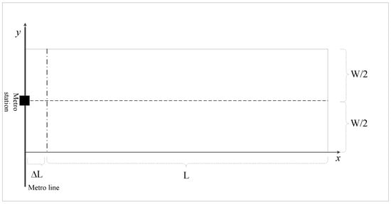
Figure 1.
Study area of feeder bus.
In this study, it is assumed that there is only one vehicle running with constant speed in the feeder bus route. The passenger travel demand is the same in different operation strategies; thus, their operation costs are similar. To represent locations of passengers and stops, a coordinate system is built (see Figure 1), and the metro station is located in . In addition, rectilinear movements, which can approach the actual traveled distance in real road networks, well are utilized [41].
3.2. Competing Operation Strategies of Feeder Bus
This study considers only one feeder bus moving with average speed . The dwell time of feeder bus stopping at each stop is . The average walking speed of passengers is . The travel demand of the service area is .
In this study, a gravity-based accessibility model is adopted to measure the feeder bus accessibility [8], which has the following form:
where is the potential accessibility of the feeder bus, is the total travel time of passenger i, which includes walking time, waiting time, and riding time, is the impedance decay factor, and N is the total number of passengers.
This study models travel time and accessibility of the feeder bus considering four operation strategies. The four operation strategies include FRT with fixed stops, FRT without fixed stops, DRT with a loop line, and DRT with separate routes. In FRT with fixed stops, passengers need to walk to the nearest stop. In FRT without fixed stops, passengers would walk to the transit route to take the feeder bus. The DRT strategy can pick up and drop off passengers at their desired locations [39]. However, they need to send their travel demands before the start of the operating cycle. For four operation strategies, the riding conditions are similar. The walking conditions are similar for the two FRT strategies. For the waiting time, pick-up passengers will wait at stops in the FRT strategies and wait at home in the DRT strategies. Thus, pick-up passengers in the DRT strategies can get better waiting experience and a discount w is given for them to show the different time values.
3.2.1. FRT with Fixed Stops
The FRT with fixed stops includes continuous service among all stops with the same intervals along the route (see Figure 2). There are M stops in total, one in the metro station, and in the service area (). This study divides the service area into zones and the travel demand of each zone is . d denotes the interval between adjacent stops, which can be calculated according to Equation (2).
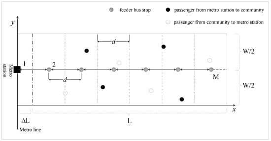
Figure 2.
FRT with fixed stops.
It is assumed that each passenger would walk along a rectilinear path to the nearest stop [40]. The expectation of walking time is calculated according to Equation (3).
The arrival time gap of the vehicle between two adjacent stops consists of the travel time and the dwell time:
For each cycle, the bus travels in the area , in the area , and dwells for a period of . Thus, the cycle time is:
As passengers can appear at any time in a cycle. The expectation of waiting time for pick-up and drop-off passengers is:
The expectation of waiting time for all passengers is:
Let M be the number of stops served by the FRT with fixed stops, since the riding time for stop i is running time and dwell time . Thus, the expectation of riding time for pick-up and drop-off passengers is:
where i is the sequence number of bus stops from the left side.
The expectation of riding time for all passengers is:
The expectation of total travel time is:
3.2.2. FRT Without Fixed Stops
FRT without fixed stops is presented in Figure 3. The vehicle will travel through the central line of the area and stop anywhere in the route as passengers require. Each passenger needs to walk from the origin to the boarding position or walk from the alighting position to the destination. It is assumed that each travel demand requires the vehicle to stop for a time to provide boarding/alighting service.
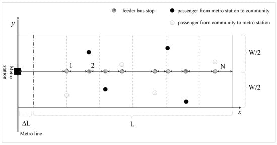
Figure 3.
FRT without fixed stops.
In FRT without fixed stops, the expectation of walking distance is . With the average walking speed , the expectation of walking time is:
The cycle time of the feeder bus which begins and ends at the metro station is:
The expectation of waiting time for pick-up and drop-off of passengers is:
The expectation of waiting time for all passengers is:
The expectation of riding time is:
3.2.3. DRT With a Loop Line
With a no-backtracking policy, DRT with a loop line moves from left to right in the upper part, and then moves from right to left in the lower part [8] (see Figure 4). As the feeder bus can provide services at the required locations, the walking distance and walking time are ignored in this strategy.
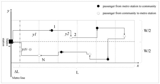
Figure 4.
DRT with a loop line.
Passengers are evenly distributed over space in the service area. According to the previous study [40], the expectation of running distance in the horizontal direction is:
Let y be a random variable which indicates the vertical distance between two adjacent passengers in the schedule [40]. It can be calculated that . Let / be the vertical distance between the metro station and the first/last passenger in the schedule. It would be . Besides, let be the vertical distance between the last passenger in the upper part and the first passenger in the lower part. It can be calculated that . Thus, the expectation of total rectilinear distance of each cycle would be:
Combining the expectation of total rectilinear distance and the average running speed, the cycle time is:
Since pick-up passengers show up, they need to wait for the end of the current cycle and the feeder bus to reach them [40], they would wait . Drop-off passengers need to wait , since they will show up and wait at the metro station uniformly from time 0 to of the current cycle.
Since pick-up passengers and drop-off passengers can be handled uniformly anytime from time 0 to T of the cycle, the riding time would be .
Thus, the expectations of the total waiting time (see Equation (19) and riding time (see Equation (20)) are:
Finally, the expectation of total travel time is:
3.2.4. DRT With Separate Routes
DRT with separate routes moves from left to right in the study area with a no-backtracking policy, and then moves from right to left in the study area with a no-backtracking policy [8] (see Figure 5).
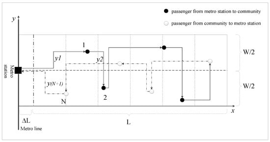
Figure 5.
DRT with separate routes.
According to the previous study [40], the expectation of running distance in the horizontal direction is:
Let y be the random variable which indicates the vertical distance between two adjacent passengers in the schedule [40]. It can be calculated that . Let / be the vertical distance between the metro station and the first/last passenger in the schedule. It would be .
Thus, the expectation of total rectilinear distance per cycle would be:
Combining the expectation of total rectilinear distance and the average running speed, the cycle time is:
The expectation of riding time for all passengers is:
For pick-up passengers, they have to wait for an average of from the show-up time to the end of the current cycle. They need to wait for the vehicle to serve the drop-off passengers first, with an average of . Besides, pick-up passengers can be served uniformly from time 0 to . Thus, the expectation of waiting time for pick-up passengers is:
Since drop-off passengers show up, they only need to wait until the end of the current cycle with an average of . Thus, drop-off passenger expectation of waiting time is:
The expectation of waiting time for all passengers is:
The expectation of total travel time is:
4. Analytical Modeling
The analytical analysis of the four operation strategies is given in this section. The parameters are set as follows [10,40]: feeder bus running speed km/h, walking speed km/h, feeder bus dwelling time s, passenger travel demand density person/km2, km, travel impedance parameter , and the ratio .
For each operation strategy, four ratio cases are considered to compare accessibility. In each case, the service area is 4 km2. In the four cases, the length and width are set as follows: Case 1 (2 km × 2 km), Case 2 (4 km × 1 km), Case 3 ( 8 km × 0.5 km ) and Case 4 (16 km × 0.25 km).
4.1. FRT with Fixed Stops
The accessibility and travel time of FRT with fixed stops is presented in Figure 6 and Figure 7, respectively. For the four cases, the number of stops when the accessibility is maximized will increase with the increase in L/W ratio. For cases with lower L/W ratios, the value of accessibility changes is greater with the increase in stop number. For cases where L/W is large, the value of accessibility becomes smaller as the number of stops increases. The number of stops is the factor that impacts the travel time of FRT with fixed stops. According to Equations (3), (7) and (9), the expectations of walking time, waiting time and riding time are all influenced by the number of stops. The travel time distribution is presented in Figure 7. With the increase in stop number, the expectation of travel time decreases at first and then increases.
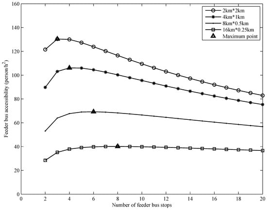
Figure 6.
The accessibility of FRT with fixed stops.
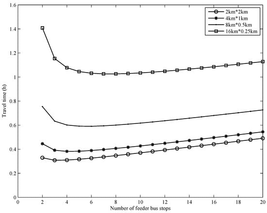
Figure 7.
The travel time of FRT with fixed stops.
When the accessibility of FRT with fixed stops is maximized, the expectations of walking time, waiting time, riding time and travel time are calculated (see Table 1). With the increase in L/W ratio, the accessibility decreases, and the number of optimal stops to maximize the accessibility increases.

Table 1.
The expectations of travel time for FRT with fixed stops when the accessibility is maximized (Unit: hour).
4.2. Feeder Bus Operation Strategies Without Fixed Stops
The expected travel times of three feeder bus operation strategies without fixed stops in the four cases are calculated and presented in Figure 8. In the four cases, the expectations of travel time have a similar pattern. When the travel demand is small, DRT with separate routes has the least expectation of travel time. When the travel demand is large, FRT without fixed stops has the least expectation of travel time. In Case 1, DRT with separate routes performs best with travel demand no more than 6 and FRT without fixed stops is the best strategy when travel demand is more than 6. With the increase in L/W, the critical values of the two strategies increase slightly.
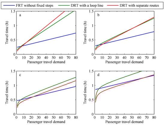
Figure 8.
The expectations of travel time for feeder bus without fixed stops in different cases: (a) 2 × 2 km; (b) 4 × 1 km; (c) 8 × 0.5 km; (d) 16 × 0.25 km.
5. Simulation Experiments
5.1. Simulation Modeling
In the simulation, the travel demand was generated randomly and evenly within the service area. There were 5000 groups of travel demands in total, and each group included 80 randomly generated passengers. One end of each travel demand was located in the metro station. It was assumed that the intrazonal travel demand did not exist. The simulation process was implemented in Matlab 2014a. During the simulation of each group, passengers were incorporated into the simulation one by one to analyze the changes in accessibility.
The simulated accessibilities of Case 1 are presented in Figure 9. In this simulation situation, when the travel demand is less than 13, DRT with separate routes has the highest accessibility. When the travel demand exceeds 13, FRT with fixed stops has the highest accessibility. Besides, when the travel demand increases, the leading superiority of FRT with fixed stops will be enlarged. When travel demand arrives at 15, FRT without fixed stops will be superior to DRT with separate routes in accessibility. DRT with a loop line and DRT with separate routes have similar accessibility curves. In view of accessibility, DRT with separate routes is the most suitable strategy for the low travel demand, which is proper to be operated by small size vehicles. When the travel demand is large, FRT with fixed stops is the most suitable strategy.
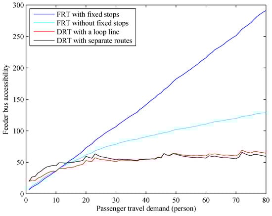
Figure 9.
The simulated accessibilities of Case 1.
The simulated accessibilities of Case 2 are presented in Figure 10. The tendencies of accessibilities are similar to those in Case 1. The dominant interval of FRT with fixed stops is enlarged and the critical value increases to 24. In Case 2, DRT with separate routes always performs better than DRT with a loop line, apparently. In addition, FRT without fixed stops surpasses DRT with separate routes in accessibility when the travel demand arrives at 26.
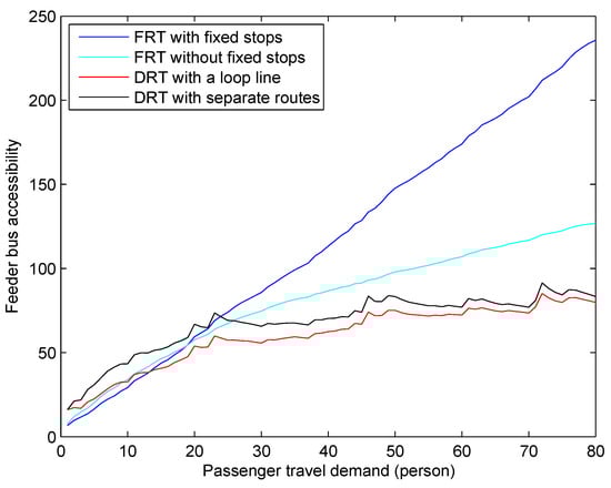
Figure 10.
The simulated accessibilities of Case 2.
The simulated accessibilities of Case 3 are presented in Figure 11. This is a bit different from Case 1 and Case 2. When the travel demand is low, DRT with separate routes performs best. However, FRT without fixed stops has the highest accessibility when the travel demand is between 30 and 36. FRT with fixed stops still performs the best with large travel demand. In addition, DRT with separate routes has higher accessibility than FRT without fixed stops in the whole range and they have similar tendency.
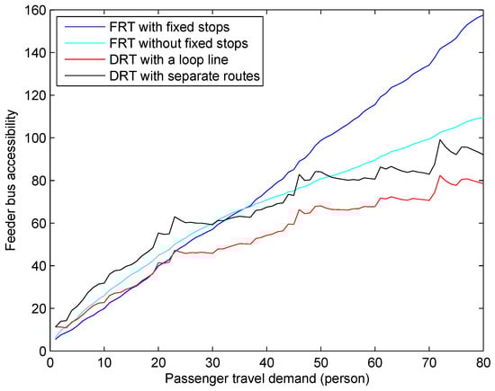
Figure 11.
The simulated accessibilities of Case 3.
The simulated accessibilities of Case 4 are presented in Figure 12. When the travel demand is less than 55, DRT with separate routes performs better than FRT with fixed stops in accessibility. When travel demand is during 32–43, FRT without fixed stops has highest accessibility.
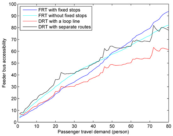
Figure 12.
The simulated accessibilities of Case 4.
In summary, DRT with separate routes has the highest accessibility when the travel demand is low, and FRT with fixed stops has the highest accessibility when the travel demand is high. In addition, the critical value would change according to the operation situation. However, FRT without fixed stops and DRT with a loop line have never been the dominant strategy from the perspective of accessibility. Furthermore, with the increase in L/W ratio, the dominant interval of DRT with separated routes will be enlarged.
5.2. Effect of
In the actual operation, the ratio of passengers of each direction was changing in different time periods. In the morning peak hours, more passengers were traveling from the community to the metro station. In the evening peak hours, more passengers were traveling from the metro station to the community. In a day, the value of changes significantly over time. This study takes Case 1 as an example to analyze the effect of on feeder bus accessibility.
Five values of are utilized to show the difference in accessibility (see Figure 13). The accessibility of FRT with fixed stops is not influenced by the value of . The curve distributions are the same for the five values (see Figure 13a).
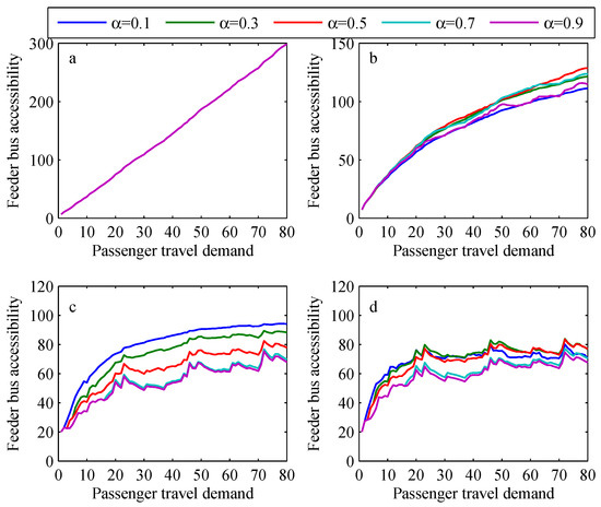
Figure 13.
The effects of on different feeder bus operation strategies: (a) FRT with fixed stops; (b) FRT without fixed stops; (c) DRT with a loop line; (d) DRT with separate routes.
For FRT without fixed stops, the accessibility curve will change with various values of . In general, the accessibility of the feeder bus is the highest with and the lowest with (see Figure 13b).
For DRT with a loop line, the accessibility shows an apparent pattern with the change in . With the increase in , the accessibility will decrease. The accessibility is the highest with and the lowest with (see Figure 13c).
For DRT with separate routes, the accessibility curves are more complex. When the travel demand increases, the accessibility curves will cross each other.
6. Conclusions
This study models and evaluates travel time and accessibility of feeder bus. Four operation strategies are taken into consideration, including FRT with fixed stops, FRT without fixed stops, DRT with a loop line and DRT with separate routes. The analytical analysis was applied to evaluate the travel time. It was found that, when the accessibility is maximized, the number of stops for FRT with fixed stops will increase with the increase in ratio.
The travel demand is generated randomly according to the given distribution. Then, the travel time of each passenger is calculated in each operation strategy. Furthermore, the feeder bus accessibility is measured in the simulation. The results show that DRT with separate routes has the highest accessibility when the travel demand is low and FRT with fixed stops has the best accessibility when the travel demand is high. The critical value of the two operation strategies will change with different values. In cases with large ratios, FRT without fixed stops has the highest accessibility in the medium travel demand.
In addition, the value of has different influences on the four operation strategies. FRT with fixed stops is completely unaffected, and FRT without fixed stops is affected slightly. At the same time, DRT with a loop line and DRT with separate routes are significantly affected.
Based on the results of this study, policy makers should select suitable operation strategies according to the actual travel demand and service areas for each case. Besides, we should pay attention to the travel pattern in the residential community so as to service the travel demand better. The operation improvement of feeder bus can help to increase attraction of metro stations. Furthermore, more passengers are attracted to ride the metro, which is a more sustainable mode.
There are also some limitations in this study. Further work will take the actual passenger demand distribution into consideration with an actual service area. Passengers’ preferences for the mode of last-mile travel will be investigated and incorporated into the modeling. Besides, more operation strategies with different speeds, capacities, and fares can be compared in further feeder bus accessibility assessment.
Author Contributions
Conceptualization, S.J., W.G. and W.Z.; methodology, S.J.; software, S.J., L.Y. and W.Z.; validation, S.J., L.Y. and W.Z.; investigation, S.J. and W.Z.; writing—original draft preparation, S.J.; writing—review and editing, W.G., L.Y. and W.Z.; visualization, S.J.; supervision, W.G.; project administration, W.G.; funding acquisition, W.G. All authors have read and agreed to the published version of the manuscript.
Funding
This research was funded by NSFC Projects grant number 61976055 and 91746201.
Conflicts of Interest
The authors declare no conflict of interest.
References
- Fan, W.; Mei, Y.; Gu, W. Optimal design of intersecting bimodal transit networks in a grid city. Transp. Res. Part B-Methodol. 2018, 111, 203–226. [Google Scholar] [CrossRef]
- Wang, H. Routing and scheduling for a last-mile transportation system. Transp. Sci. 2019, 53, 131–147. [Google Scholar] [CrossRef]
- Chandra, S.; Quadrifoglio, L. A model for estimating the optimal cycle length of demand responsive feeder transit services. Transp. Res. Part B-Methodol. 2013, 51, 1–16. [Google Scholar] [CrossRef]
- Politis, I.; Fyrogenis, I.; Papadoulos, E.; Nikolaidou, A.; Verani, E. Shifting to Shared Wheels: Factors Affecting Dockless Bike-Sharing Choice for Short and Long Trips. Sustainability 2020, 12, 8205. [Google Scholar] [CrossRef]
- Macioszek, E.; Swierk, P.; Kurek, A. The Bike-Sharing System as an Element of Enhancing Sustainable Mobility—A Case Study based on a City in Poland. Sustainability 2020, 12, 3285. [Google Scholar] [CrossRef]
- Macioszek, E.; Kurek, A. The Use of a Park and Ride System—A Case Study Based on the City of Cracow (Poland). Energies 2020, 13, 3473. [Google Scholar] [CrossRef]
- Georgiadis, G.; Politis, I.; Papaioannou, P. How Does Operational Environment Influence Public Transport Effectiveness? Evidence from European Urban Bus Operators. Sustainability 2020, 12, 4919. [Google Scholar] [CrossRef]
- Chandra, S.; Bari, M.E.; Devarasetty, P.C.; Vadali, S. Accessibility evaluations of feeder transit services. Res. Part A-Policy Pract. 2013, 52, 47–63. [Google Scholar] [CrossRef]
- Wu, S.; Zhuang, Y.; Chen, J.; Wang, W.; Bai, Y.; Lo, S. Rethinking bus-to-metro accessibility in new town development: Case studies in Shanghai. Cities 2019, 94, 211–224. [Google Scholar] [CrossRef]
- Tang, Q.; Du, P. Study on Accessibility of Feeder Lines with Different Geometric Shapes. J. Adv. Transp. 2020, 2020, 4040252. [Google Scholar] [CrossRef]
- Hansen, W.G. How accessibility shapes land use. J. Am. Inst. Plan. 1959, 25, 73–76. [Google Scholar] [CrossRef]
- Burns, L.D.; Golob, T.F. The role of accessibility in basic transportation choice behavior. Transportation 1976, 5, 175–198. [Google Scholar] [CrossRef]
- Geurs, K.T.; Wee, B.V. Accessibility evaluation of land-use and transport strategies: Review and research directions. J. Transp. Geogr. 2004, 12, 127–140. [Google Scholar] [CrossRef]
- Jacobs-Crisioni, C.; Silva, F.B.; Lavalle, C.; Baranzelli, C.; Barbosa, A.; Castillo, C.P. Accessibility and territorial cohesion in a case of transport infrastructure improvements with changing population distributions. Eur. Transp. Res. Rev. 2016, 8, 1–16. [Google Scholar] [CrossRef]
- Hu, Y.; Downs, J. Measuring and visualizing place-based space-time job accessibility. J. Transp. Geogr. 2019, 74, 278–288. [Google Scholar] [CrossRef]
- Brabyn, L.; Sutton, S. A population based assessment of the geographical accessibility of outdoor recreation opportunities in New Zealand. Appl. Geogr. 2013, 41, 124–131. [Google Scholar] [CrossRef]
- Xu, W.; Yang, L. Evaluating the urban land use plan with transit accessibility. Sust. Cities Soc. 2019, 45, 474–485. [Google Scholar] [CrossRef]
- Balsa-Barreiro, J.; Ambuuhl, L.; Menendez, M.; Pentland, A. Mapping Time-Varying Accessibility and Territorial Cohesion With Time-Distorted Maps. IEEE Access 2019, 7, 1–13. [Google Scholar] [CrossRef]
- Boisjoly, G.; El-Geneidy, A. Daily fluctuations in transit and job availability: A comparative assessment of time-sensitive accessibility measures. J. Transp. Geogr. 2016, 52, 73–81. [Google Scholar] [CrossRef]
- Miller, E.J. Accessibility: Measurement and application in transportation planning. Transp. Rev. 2018, 38, 551–555. [Google Scholar] [CrossRef]
- Fayyaz, S.K.; Liu, X.C.; Porter, R.J. Dynamic transit accessibility and transit gap causality analysis. J. Transp. Geogr. 2017, 59, 27–39. [Google Scholar] [CrossRef]
- Paez, A.; Scott, D.M.; Morency, C. Measuring accessibility: Positive and normative implementations of various accessibility indicators. J. Transp. Geogr. 2012, 25, 141–153. [Google Scholar] [CrossRef]
- Martens, K.; Ciommo, F.D. Travel time savings, accessibility gains and equity effects in cost benefit analysis. Transp. Rev. 2017, 37, 1–18. [Google Scholar] [CrossRef]
- Stokes, E.C.; Seto, K.C. Tradeoffs in environmental and equity gains from job accessibility. Proc. Natl. Acad. Sci. USA 2018, 115, E9773–E9781. [Google Scholar] [CrossRef]
- Bocarejo, J.P.; Escobar, D.; Hernandez, D.O.; Galarza, D. Accessibility analysis of the integrated transit system of Bogotá. Int. J. Sustain. Transp. 2016, 10, 308–320. [Google Scholar] [CrossRef]
- Xu, W.; Ding, Y.; Zhou, J.; Li, Y. Transit accessibility measures incorporating the temporal dimension. Cities 2015, 46, 55–66. [Google Scholar] [CrossRef]
- Mavoa, S.; Witten, K.; Mccreanor, T.; O’Sullivan, D. GIS based destination accessibility via public transit and walking in Auckland, New Zealand. J. Transp. Geogr. 2012, 20, 15–22. [Google Scholar] [CrossRef]
- Tilahun, N.; Fan, Y. Transit and job accessibility: An empirical study of access to competitive clusters and regional growth strategies for enhancing transit accessibility. Transp. Policy 2014, 33, 17–25. [Google Scholar] [CrossRef]
- Tong, L.; Zhou, X.; Miller, H.J. Transportation network design for maximizing space-time accessibility. Transp. Res. Part B-Methodol. 2015, 81, 555–576. [Google Scholar] [CrossRef]
- Di, Z.; Yang, L.; Qi, J.; Gao, Z. Transportation network design for maximizing flow-based accessibility. Transp. Res. Pt. B-Methodol. 2018, 110, 209–238. [Google Scholar] [CrossRef]
- Nocera, S.; Pungillo, G.; Bruzzone, F. How to evaluate and plan the freight-passengers first-last mile. Transp. Policy 2020. Accepted. [Google Scholar] [CrossRef]
- Zuo, T.; Wei, H.; Chen, N. Promote transit via hardening first-and-last-mile accessibility: Learned from modeling commuters’ transit usey. Transport. Res. Part D-Transport. Environ. 2020, 86, 102446. [Google Scholar] [CrossRef]
- Bruzzone, F.; Scorrano, M.; Nocera, S. The combination of e-bike-sharing and demand-responsive transport systems in rural areas: A case study of Velenje. Res. Transp. Bus. Manag. 2020. Accepted. [Google Scholar] [CrossRef]
- Tilahun, N.; Thakuriah, P.; Li, M.; Keita, Y. Transit use and the work commute: Analyzing the role of last mile issues. J. Transp. Geogr. 2016, 54, 359–368. [Google Scholar] [CrossRef]
- Charles, P.; Galiza, R. Improving rail station access in Australia. Pancreas 2013, 23, 218–220. [Google Scholar]
- Wei, Q. Studies on Urban Bus Mocro-Circulation Based on Accessibility. Ph.D. Thesis, Southwest Jiaotong University, Chengdu, China, 2014. [Google Scholar]
- Currie, G.; Wong, T. Workshop 4 report: Realising the potential benefits of demand-responsive travel. Res. Transp. Econ. 2008, accepted. [Google Scholar] [CrossRef]
- Lu, X.; Yu, J.; Yang, X.; Pan, S.; Zou, N. Flexible feeder transit route design to enhance service accessibility in urban area. J. Adv. Transp. 2016, 50, 507–521. [Google Scholar] [CrossRef]
- Li, X.; Quadrifoglio, L. Feeder transit services: Choosing between fixed and demand responsive policy. Transp. Res. Part C-Emerg. Technol. 2010, 18, 770–780. [Google Scholar] [CrossRef]
- Quadrifoglio, L.; Li, X. A methodology to derive the critical demand density for designing and operating feeder transit services. Transp. Res. Pt. B-Methodol. 2009, 43, 922–935. [Google Scholar] [CrossRef]
- Quadrifoglio, L.; Dessouky, M.M.; Ordonez, F. A simulation study of demand responsive transit system design. Res. Part A-Policy Pract. 2008, 42, 718–737. [Google Scholar] [CrossRef]


Publisher’s Note: MDPI stays neutral with regard to jurisdictional claims in published maps and institutional affiliations. |
© 2020 by the authors. Licensee MDPI, Basel, Switzerland. This article is an open access article distributed under the terms and conditions of the Creative Commons Attribution (CC BY) license (http://creativecommons.org/licenses/by/4.0/).