GIS Crime Mapping to Support Evidence-Based Solutions Provided by Community-Based Organizations
Abstract
1. Introduction
1.1. Background
1.2. The Current Study and Research Objectives
2. Materials and Methods
2.1. Schematic Design
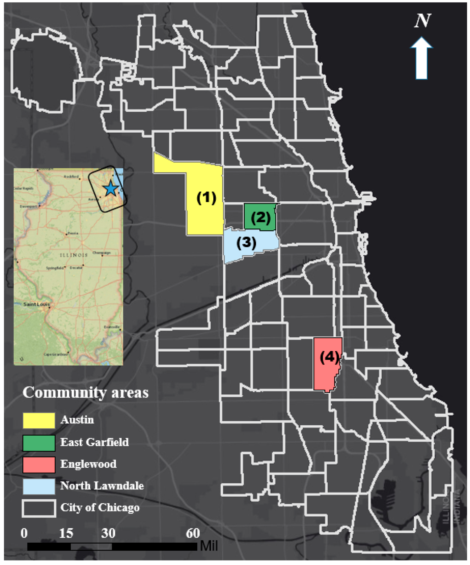
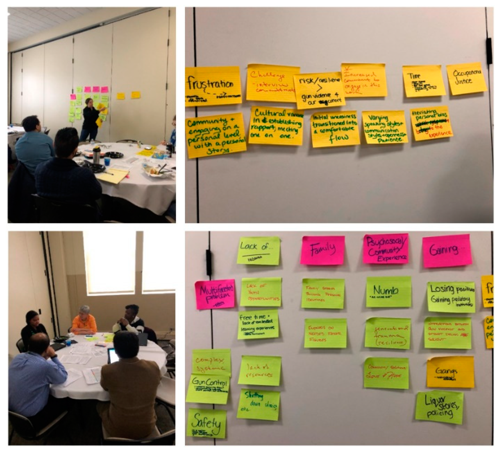
2.2. Data Collection and Mapping
2.3. Spatial Analysis and Statistics
2.4. Developing an Interactive Map and Mobile GIS Applications
3. Results
3.1. Safe Passage Routes and Gun-Related Incidents by Location
3.1.1. Safe Passage Routes
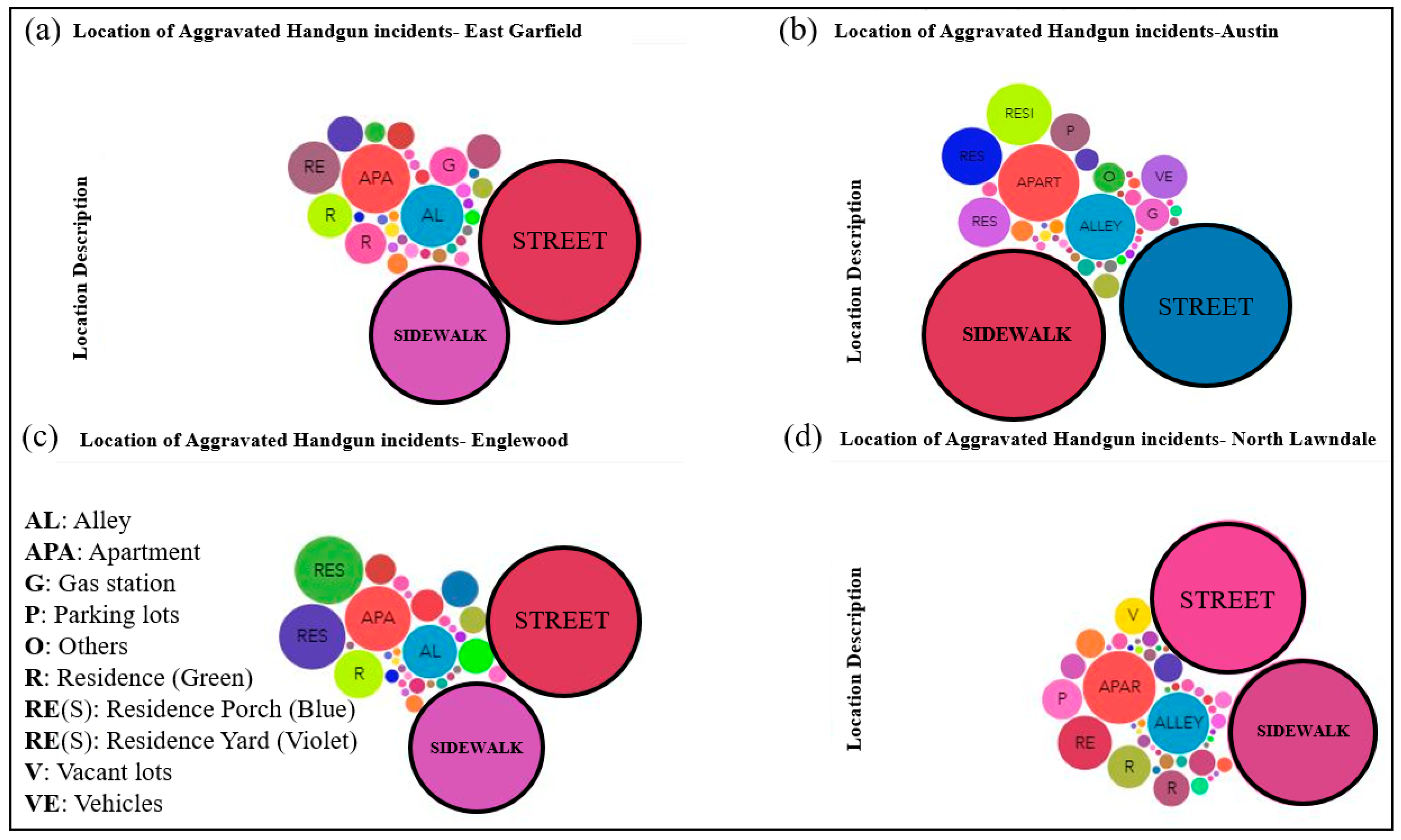
3.1.2. Gun-Related Incidents by Location
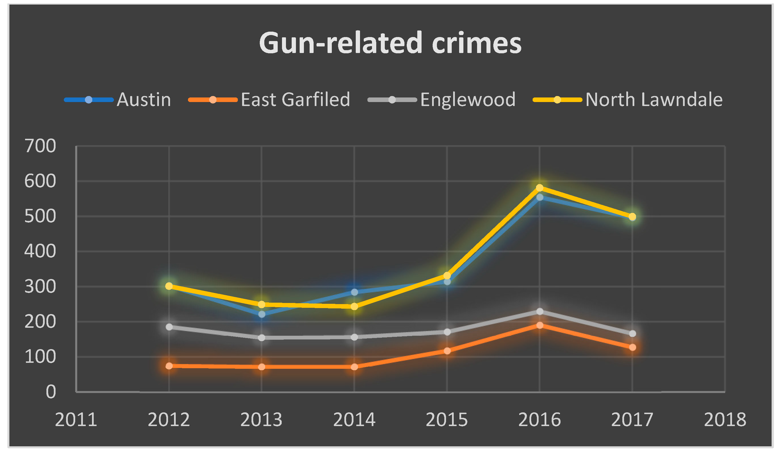
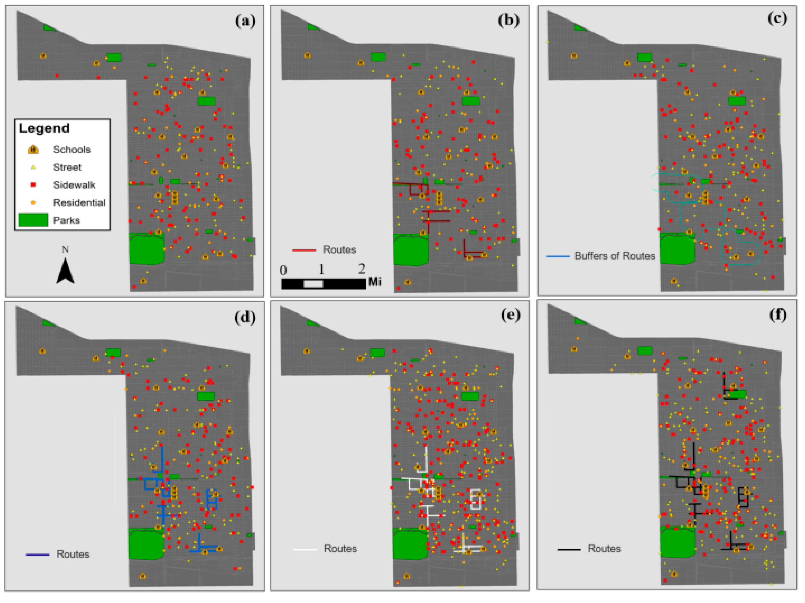
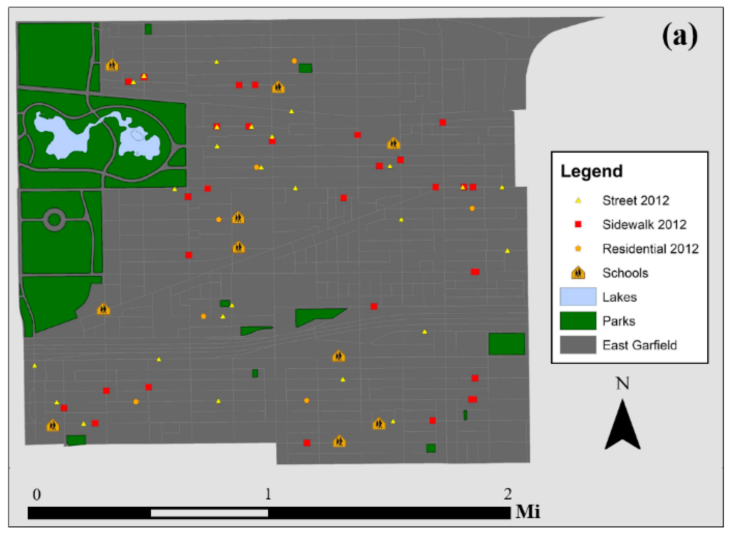
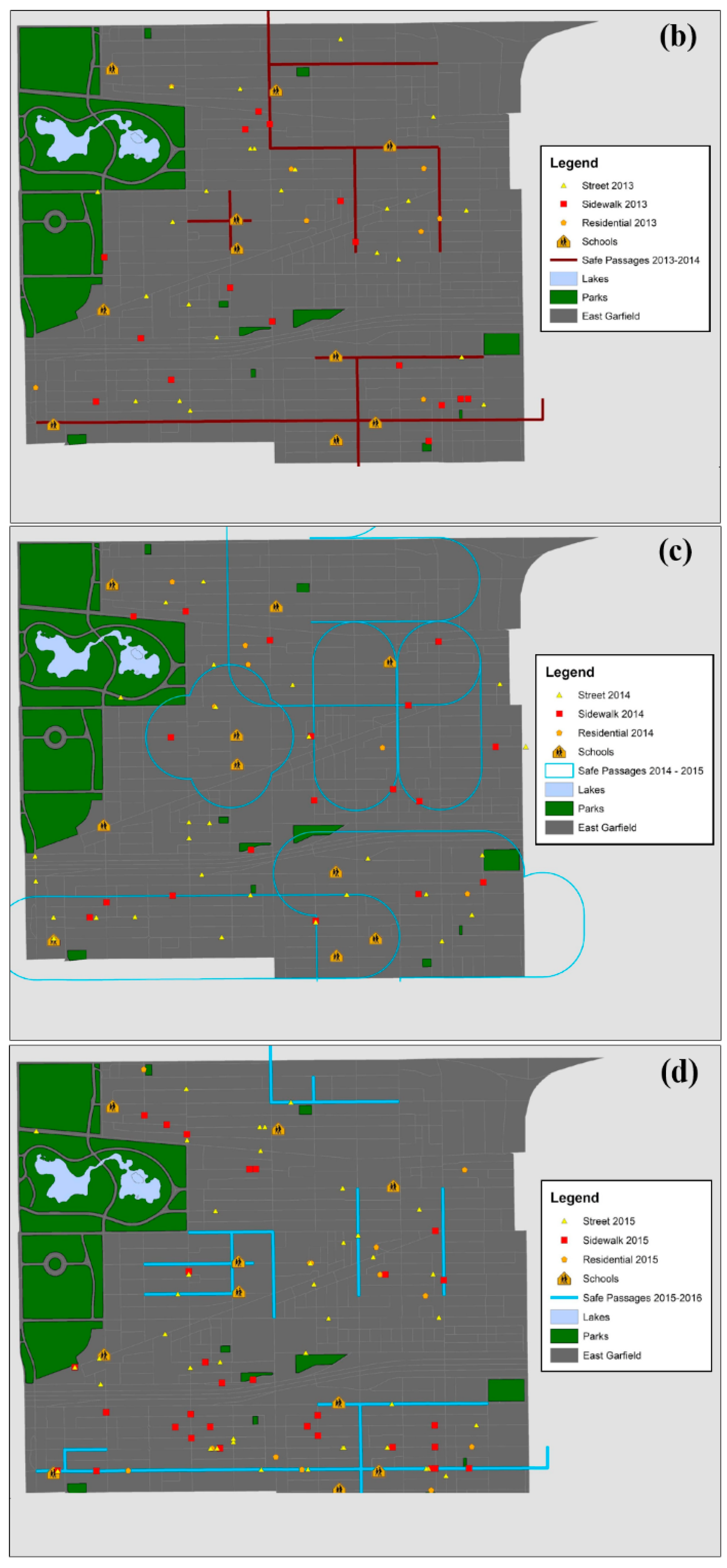
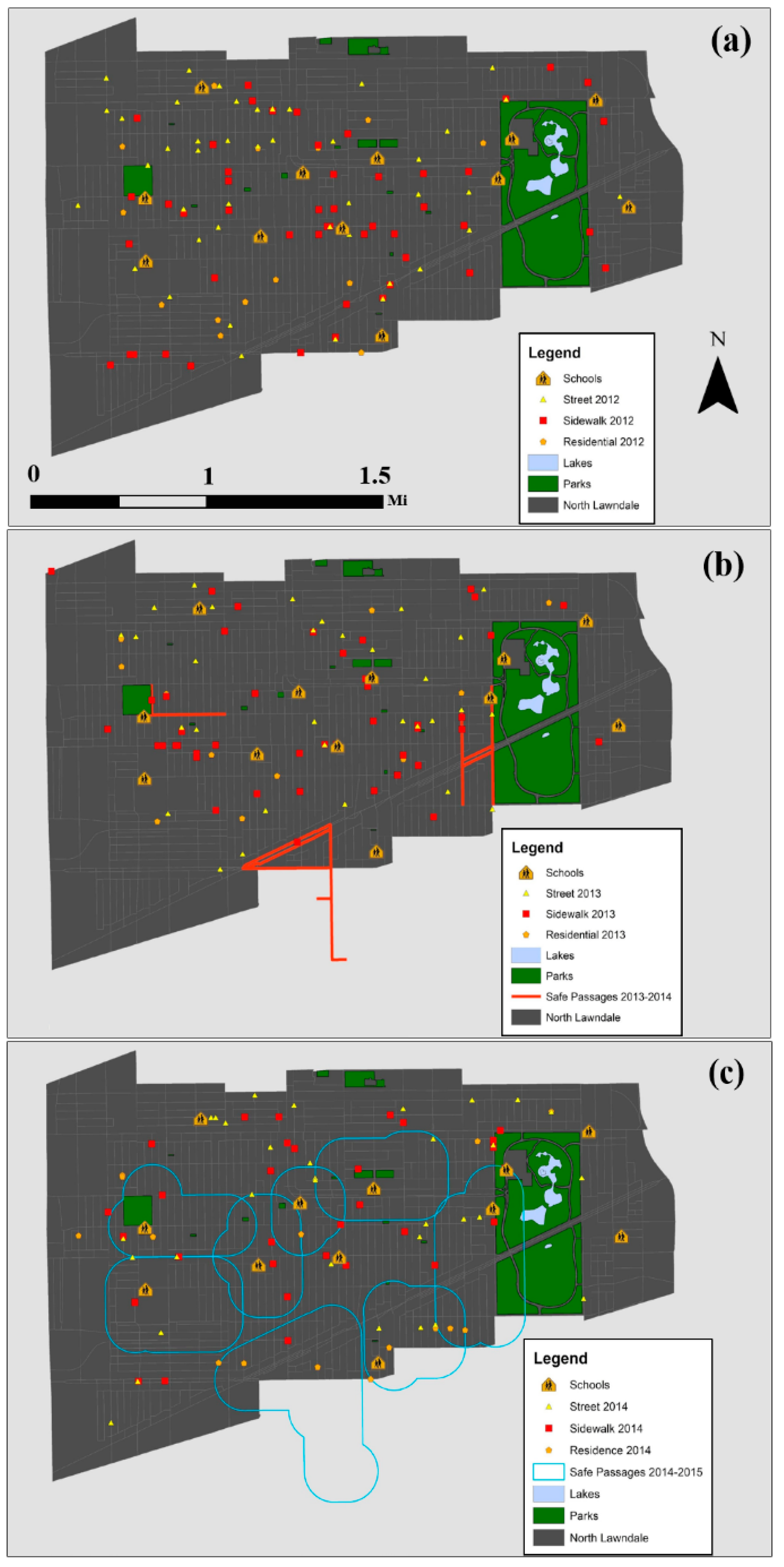
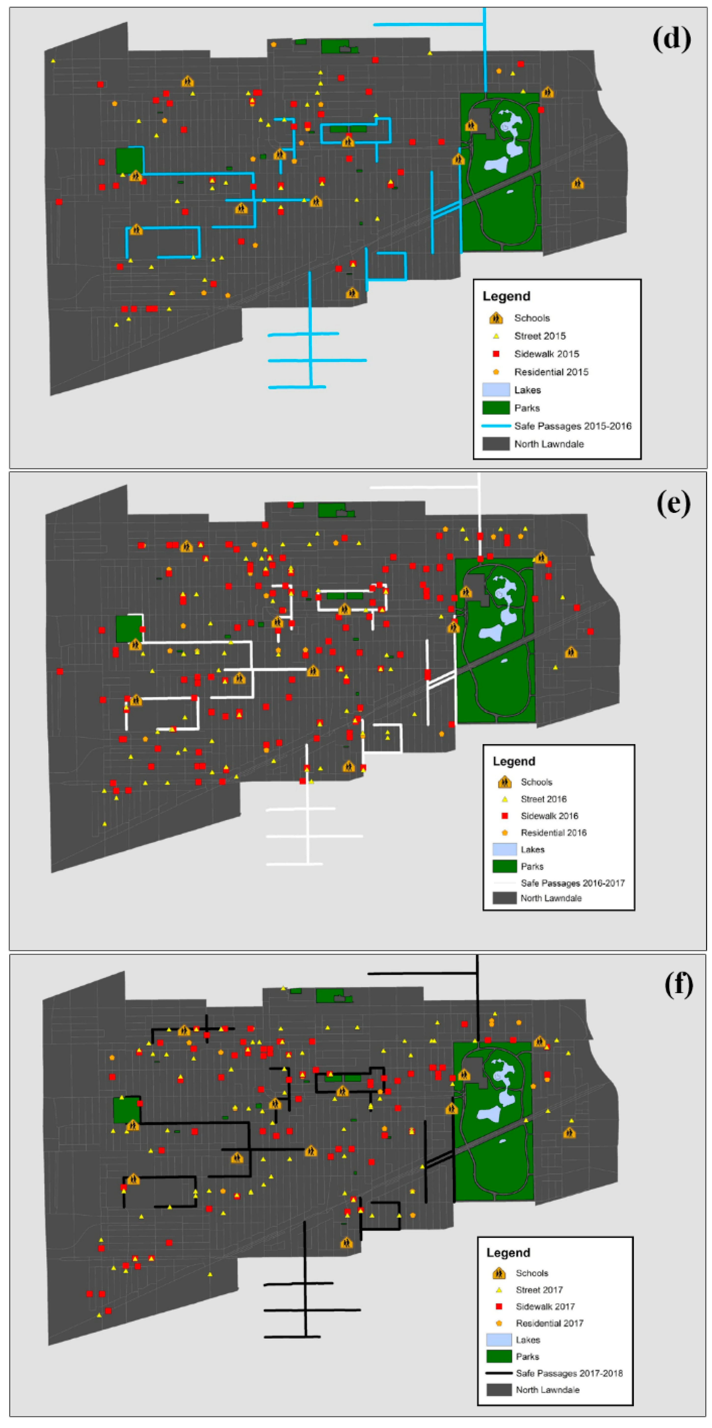
3.2. Spatially Visualizing Gun-Related Crimes and Safe Passage Routes
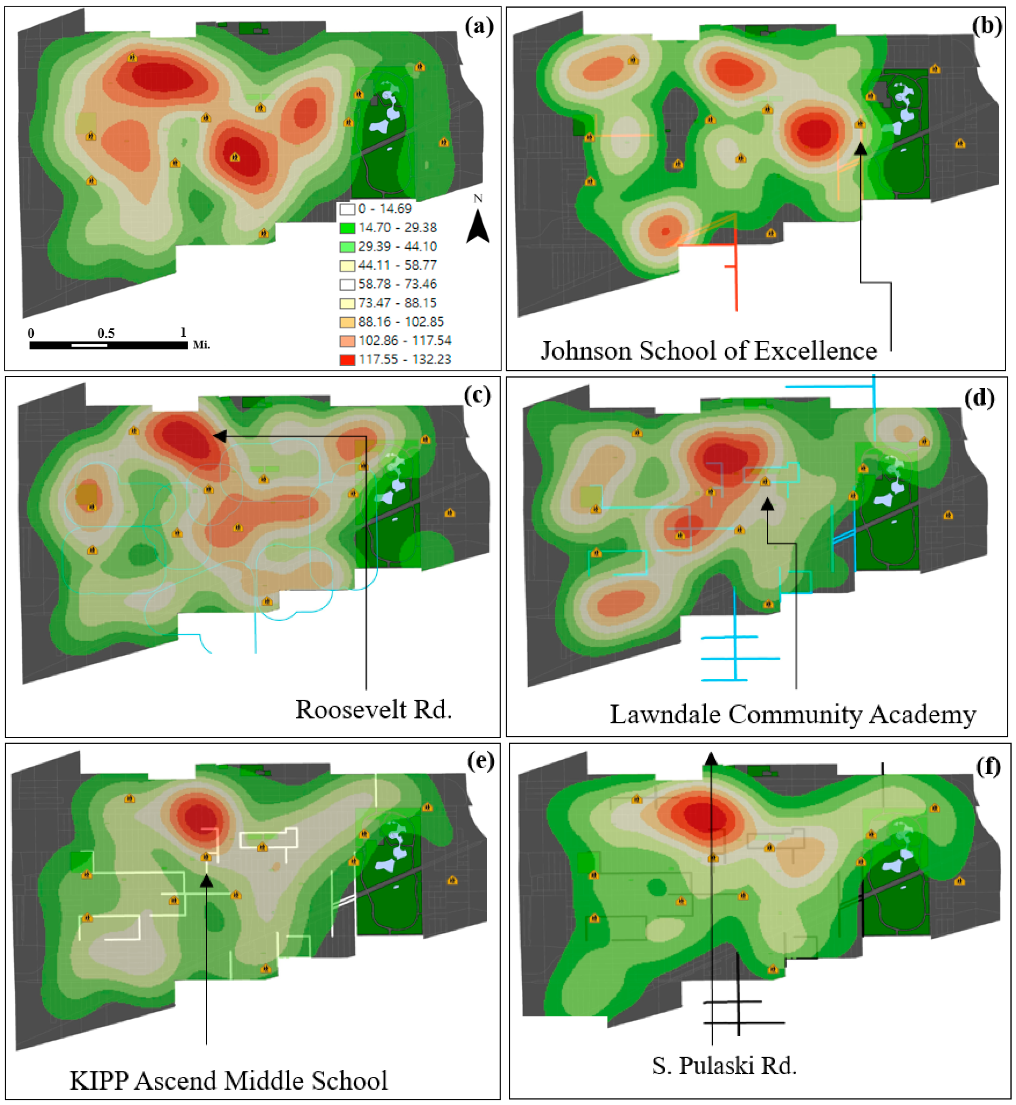
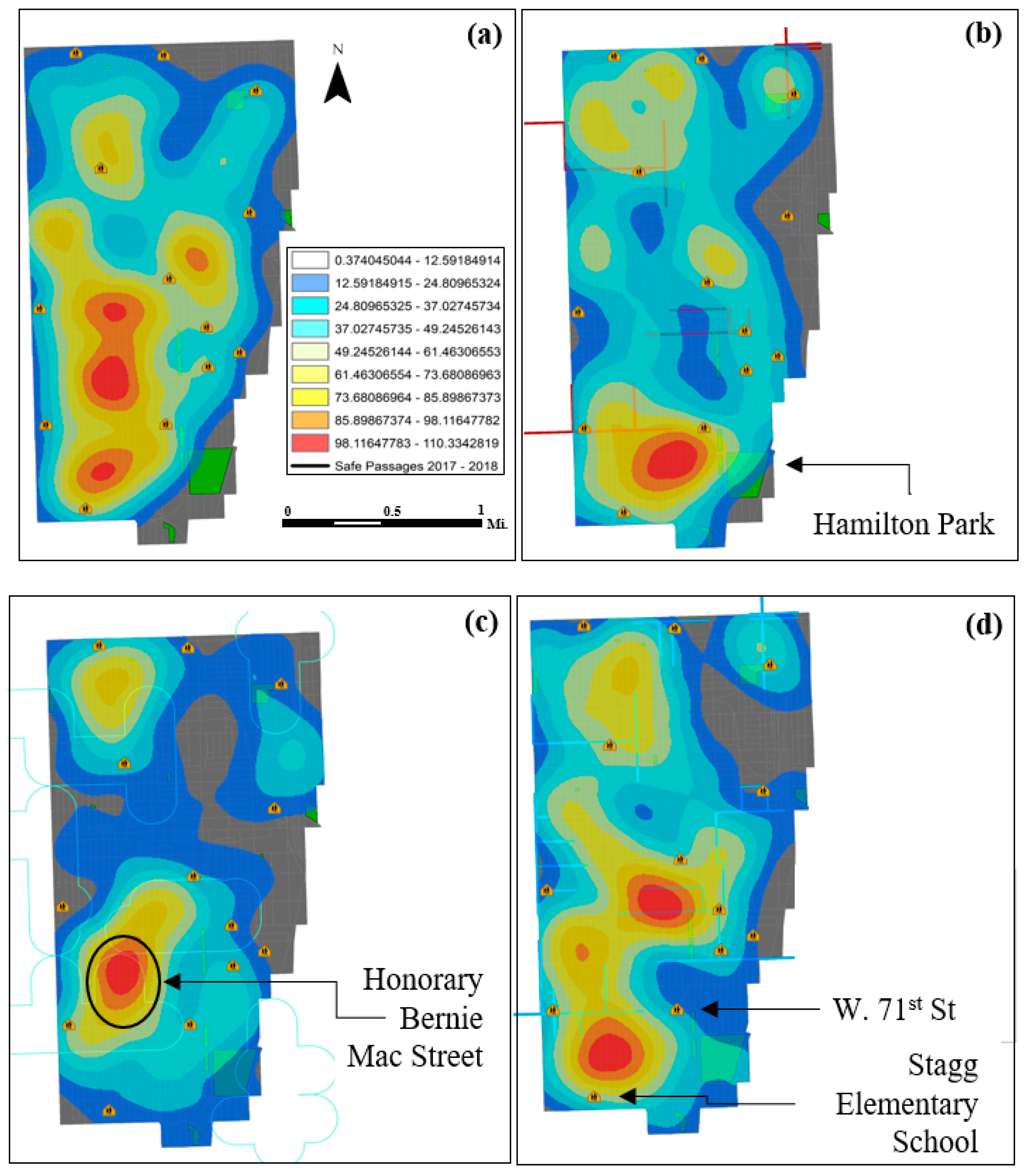
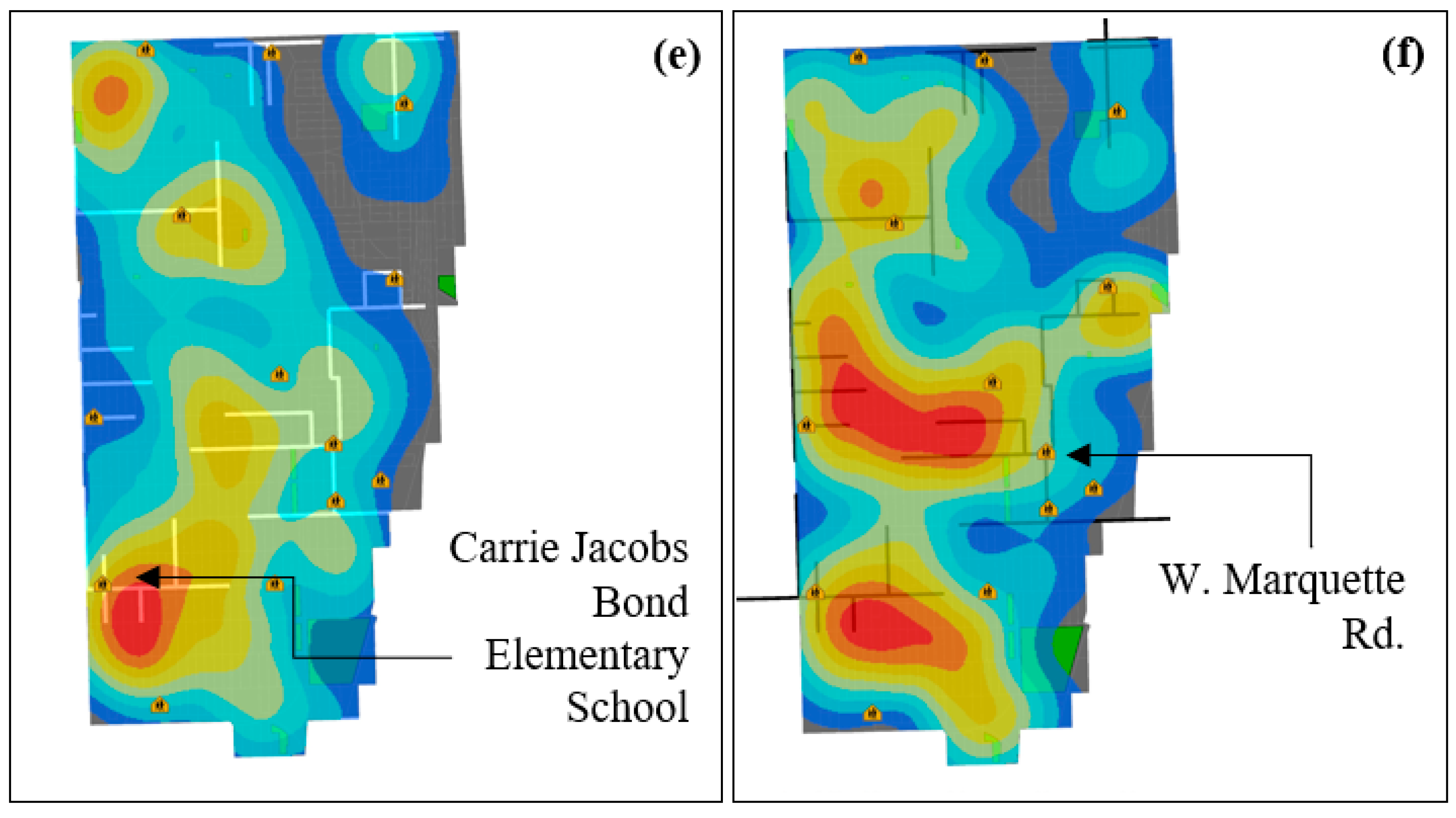
3.3. Density Mapping
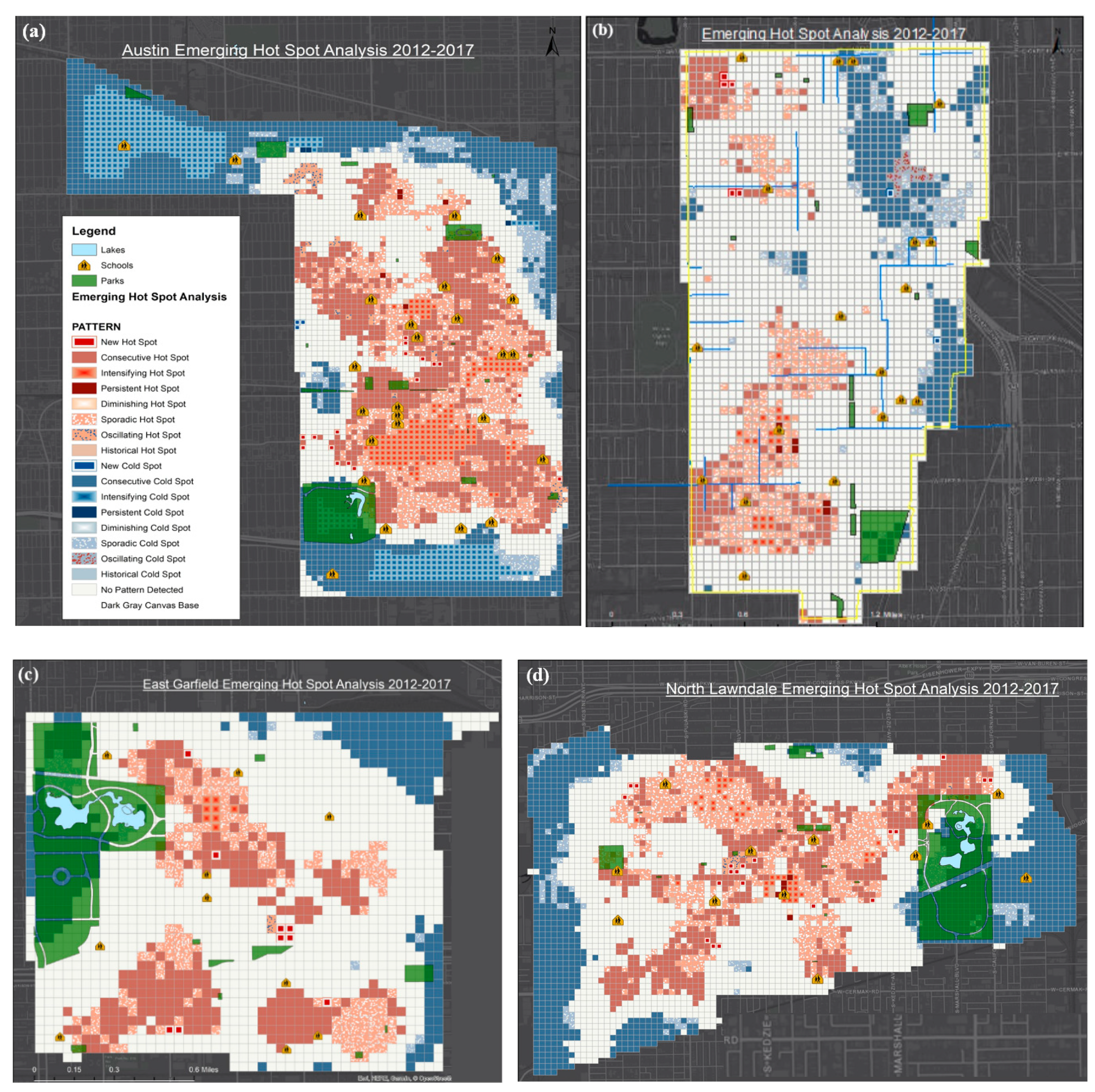
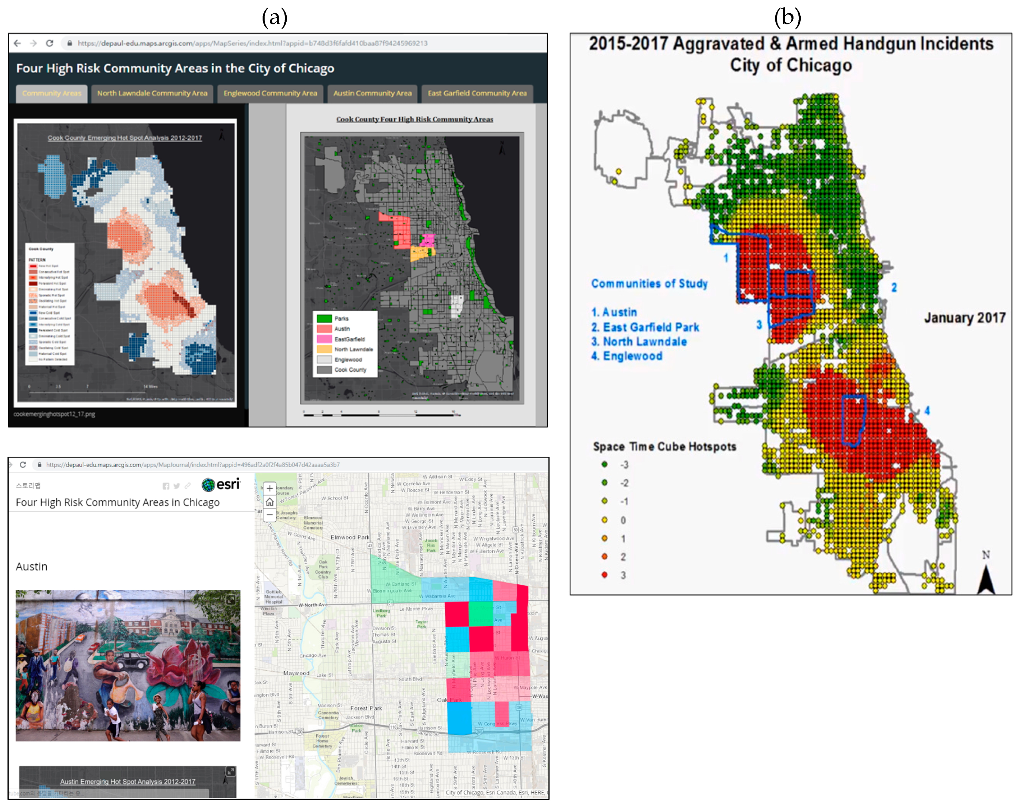
3.4. Optimized and Emerging Hotspot Analysis
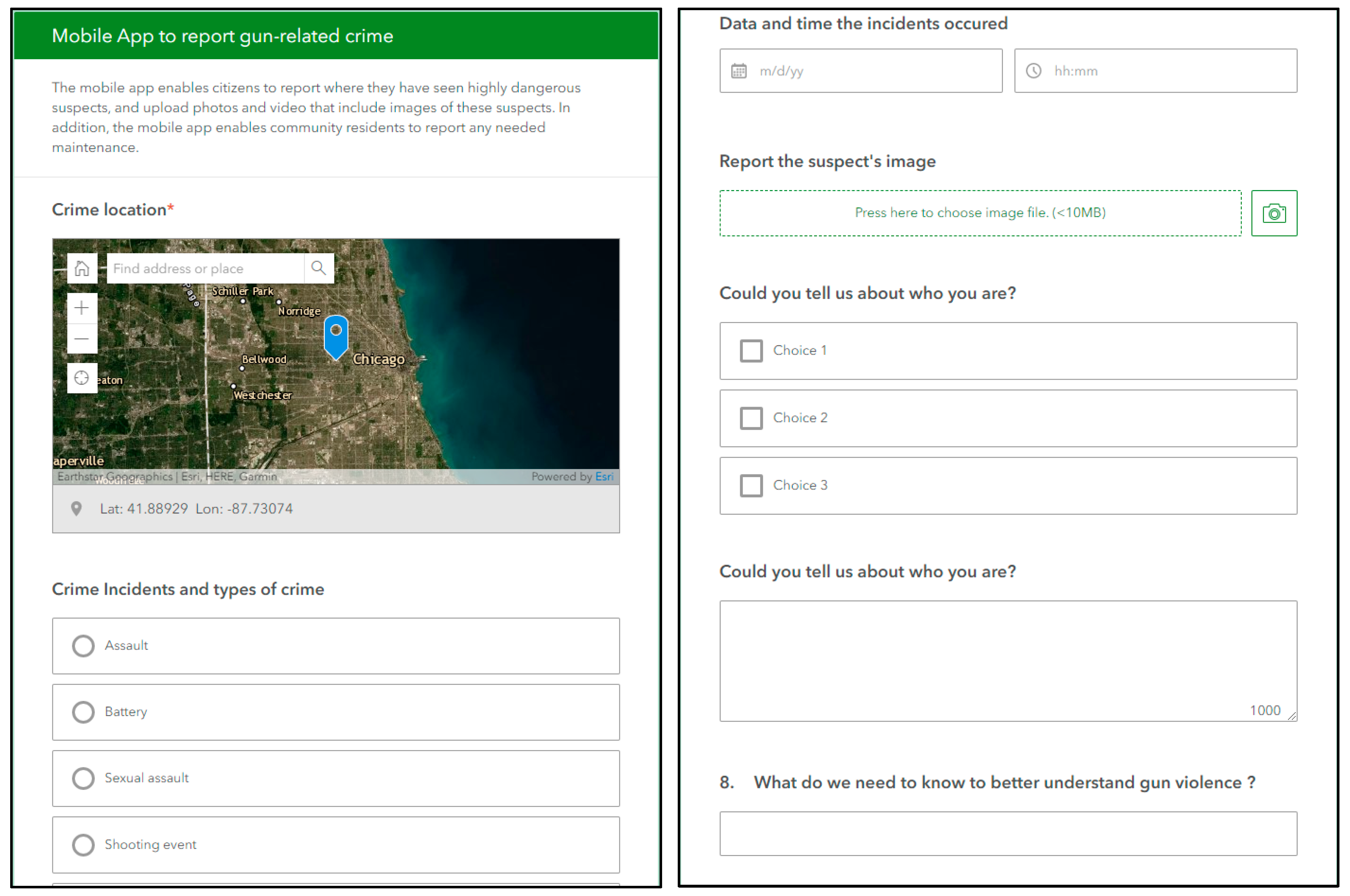
3.5. Developing Web-Enabled and Mobile GIS Applications
4. Discussion
5. Conclusions
Funding
Acknowledgments
Conflicts of Interest
References
- Grinshteyn, E.; Hemenway, D. Violent death rates: The US compared with other high-income OECD countries, 2010. Am. J. Med. 2016, 129, 266–273. [Google Scholar] [CrossRef]
- Wertz, J.; Azrael, D.; Hemenway, D.; Sorenson, S.; Miller, M. Differences between new and long-standing US gun owners: results from a national survey. Am. J. Public Health 2018, 108, 871–877. [Google Scholar] [CrossRef]
- Sierra-Arévalo, M. Legal cynicism and protective gun ownership among active offenders in Chicago. Cogent Soc. Sci. 2016, 2, 1227293. [Google Scholar] [CrossRef]
- Simonetti, J.A.; Azrael, D.; Rowhani-Rahbar, A.; Miller, M. Firearm storage practices among American veterans. Am. J. Prev. Med. 2018, 55, 445–454. [Google Scholar] [CrossRef]
- University of Chicago Crime Lab. Gun Violence in Chicago. 2016. Available online: https://urbanlabs.uchicago.edu/attachments/c5b0b0b86b6b6a9309ed88a9f5bbe5bd892d4077/store/82f93d3e7c7cc4c5a29abca0d8bf5892b3a35c0c3253d1d24b3b9d1fa7b8/UChicagoCrimeLab%2BGun%2BViolence%2Bin%2BChicago%2B2016.pdf (accessed on 10 April 2019).
- Federal Bureau of Investigation. Uniform Crime Reporting Program. Available online: https://www.opendatanetwork.com/entity/1600000US1714000-1600000US3651000/Chicago_IL-New_York_NY/crime.fbi_ucr.rate?crime_type=All%20Crimes&year=2017 (accessed on 10 May 2019).
- Chicago News. Dick Durbin Says Railway Must Do More to Prevent Gun Thefts. Available online: https://chicago.suntimes.com/news/durbin-says-railway-must-do-more-on-gun-thefts/ (accessed on 15 March 2018).
- Paddock, E.; Samuels, J.; Vinik, N.; Overton, S. Federal Actions to Engage Communities in Reducing Gun Violence; Urban Institute: Washington, DC, USA, 2017. Available online: https://www.urban.org/sites/default/files/federal_actions_to_engage_communities-in-reducing-gun-violence.pdf (accessed on 10 March 2019).
- Sinai Health System (SINAI). Community Health Needs Assessment Schwab Rehabilitation Hospital. 2016. Available online: https://www.sinai.org/sites/default/files/HCH%20CHNA_final_revised_%20(1).pdf (accessed on 11 November 2018).
- Chicago Tribute. School Board Votes to Close 49 Schools. 2013. Available online: http://graphics.chicagotribune.com/school_utilization/ (accessed on 11 May 2019).
- De la Torre, M.; Gwynne, J. When Schools Close: Effects on Displaced Students in Chicago Public Schools. Research Report; Consortium on Chicago School Research: Chicago, IL, USA, 2009. [Google Scholar]
- Chicago Tribute. CPS Release Maps of ‘Safe Passage’ Routes. 2013. Available online: https://www.chicagotribune.com/news/ct-xpm-2013-08-09-chi-cps-releases-maps-of-safe-passage-routes-20130809-story.html (accessed on 11 January 2019).
- Hartz, T. Safe Passage Program Expands to 14 More Schools. Available online: https://chicago.suntimes.com/education/chicago-public-schools-safe-passage-expanded/ (accessed on 21 January 2018).
- Chicago Public School. CPS Expand Safe Passage to 14 Additional Schools. Available online: https://www.chicago.gov/city/en/depts/mayor/press_room/press_releases/2018/january/SafePassageExpansion.html. (accessed on 21 January 2018).
- Camille, W.; Leah, B.; Jess, L. Community Listening Session Report; SUHI: Chicago, IL, USA, 2018; Available online: https://docs.wixstatic.com/ugd/fbbfe0_c877589d54ed4e47914d0c41453fa9bb.pdf (accessed on 11 September 2018).
- Routliffe, K. Student researchers see Chicago communities as partners in gun violence research. Chicago Trubuen. 29 March 2018. Available online: https://www.chicagotribune.com/suburbs/wilmette/ct-wml-gun-violence-researchers-tl-0405-story.html (accessed on 20 November 2018).
- Goodchild, M.F. Citizens as sensors: The world of volunteered geography. GeoJournal 2007, 69, 211–221. [Google Scholar] [CrossRef]
- Goodchild, M.F. Neo Geography and the nature of geographic expertise. J. Locat. Based Serv. 2009, 3, 82–96. [Google Scholar] [CrossRef]
- Goodchild, M.F.; Li, L. Assuring the quality of volunteered geographic information. Spat. Stat. 2012, 1, 110–120. [Google Scholar] [CrossRef]
- Sui, D.; Goodchild, M. The convergence of GIS and social media: Challenges for GIScience. Int. J. Geogr. Inf. Sci. 2011, 25, 1737–1748. [Google Scholar] [CrossRef]
- Elwood, S. Volunteered geographic information: Future research directions motivated by critical, participatory, and feminist GIS. GeoJournal 2008, 72, 173–183. [Google Scholar] [CrossRef]
- Elwood, S.; Goodchild, M.F.; Sui, D.Z. Researching Volunteered Geographic Information: Spatial Data, Geographic Research, and New Social Practice. Ann. Assoc. Am. Geogr. 2012, 102, 571–590. [Google Scholar] [CrossRef]
- City of Chicago. Chicago Data Portal. 2018. Available online: https://data.cityofchicago.org/ (accessed on 1 December 2018).
- Federal Bureau of Investigation. Uniform Crime Reporting (UCR) Program. 2019. Available online: https://www.fbi.gov (accessed on 20 June 2019).
- Bolstad, P. GIS Fundamentals. A First Text on Geographic Information Systems; Eider Press: Paris, France, 2005. [Google Scholar]
- Spencer, C.; Ratcliffe, J. GIS and Crime Mapping; John Wiley & Sons: Hoboken, NJ, USA, 2013. [Google Scholar]
- Dewan, A.M.; Haider, M.R.; Amin, M.R. Exploring Crime Statistics. In Dhaka Megacity; Dewan, A., Corner, R., Eds.; Springer: Dordrecht, The Netherlands, 2014; pp. 257–282. [Google Scholar]
- Elwood, S. Critical issues in participatory GIS: Deconstructions, reconstructions, and new research directions. Trans. Gis 2006, 10, 693–708. [Google Scholar] [CrossRef]
- Breetzke, G.D. The concentration of urban crime in space by race: Evidence from South Africa. Urban Geogr. 2018, 39, 1195–1220. [Google Scholar] [CrossRef]
- Breetzke, G.D.; Edelstein, I.S.; Secur, J. The spatial concentration and stability of crime in a South African township. Secur. J. 2019, 32, 63–78. [Google Scholar] [CrossRef]
- Anselin, L. Exploring Spatial Data with GeoDaTM: A Workbook. 2005, pp. 138–147. Available online: http://www.csiss.org/clearinghouse/GeoDa/geodaworkbook.pdf (accessed on 20 June 2019).
- Goodchild, M.F. Spatial thinking and the GIS user interface. Procedia-Soc. Behav. Sci. 2011, 21, 3–9. [Google Scholar] [CrossRef]
- De Smith, M.J.; Goodchild, M.F.; Longley, P. Geospatial Analysis: A Comprehensive Guide to Principles, Techniques and Software Tools; Troubador Publishing Ltd.: Leicester, UK, 2007. [Google Scholar]
- Wang, D.; Ding, W.; Lo, H.; Stepinski, T.; Salazar, J.; Morabito, M. Crime hotspot mapping using the crime related factors—A spatial data mining approach. Appl. Intell. 2013, 39, 772–781. [Google Scholar] [CrossRef]
- Getis, A.; Ord, J.K. The Analysis of Spatial Association by Use of Distance Statistics. Geogr. Anal. 1992, 24. [Google Scholar] [CrossRef]
- Ord, J.K.; Getis, A. Local Spatial Autocorrelation Statistics: Distributional Issues and an Application. Geogr. Anal. 1995, 27, 286–306. [Google Scholar] [CrossRef]
- Monsuru, A.; Rosser, G.; Cheng, T. Novel evaluation metrics for sparse spatio-temporal point process hotspot predictions—A crime case study. Int. J. Geogr. Inf. Sci. 2016, 30, 2133–2154. [Google Scholar]
- Gorr, W.L.; Kurland, K.S.; Dodson, Z.M. GIS Tutorial for Crime Analysis; Esri Press: Redlands, CA, USA, 2012. [Google Scholar]
- Coyan, J.A.; Zientek, M.L.; Mihalasky, M.J. Spatiotemporal Analysis of Changes in Lode Mining Claims Around the McDermitt Caldera, Northern Nevada and Southern Oregon. Nat. Resour. Res. 2017, 26, 319–337. [Google Scholar] [CrossRef][Green Version]
- Pánek, J. From mental maps to GeoParticipation. Cartogr. J. 2016, 53, 300–307. [Google Scholar] [CrossRef]


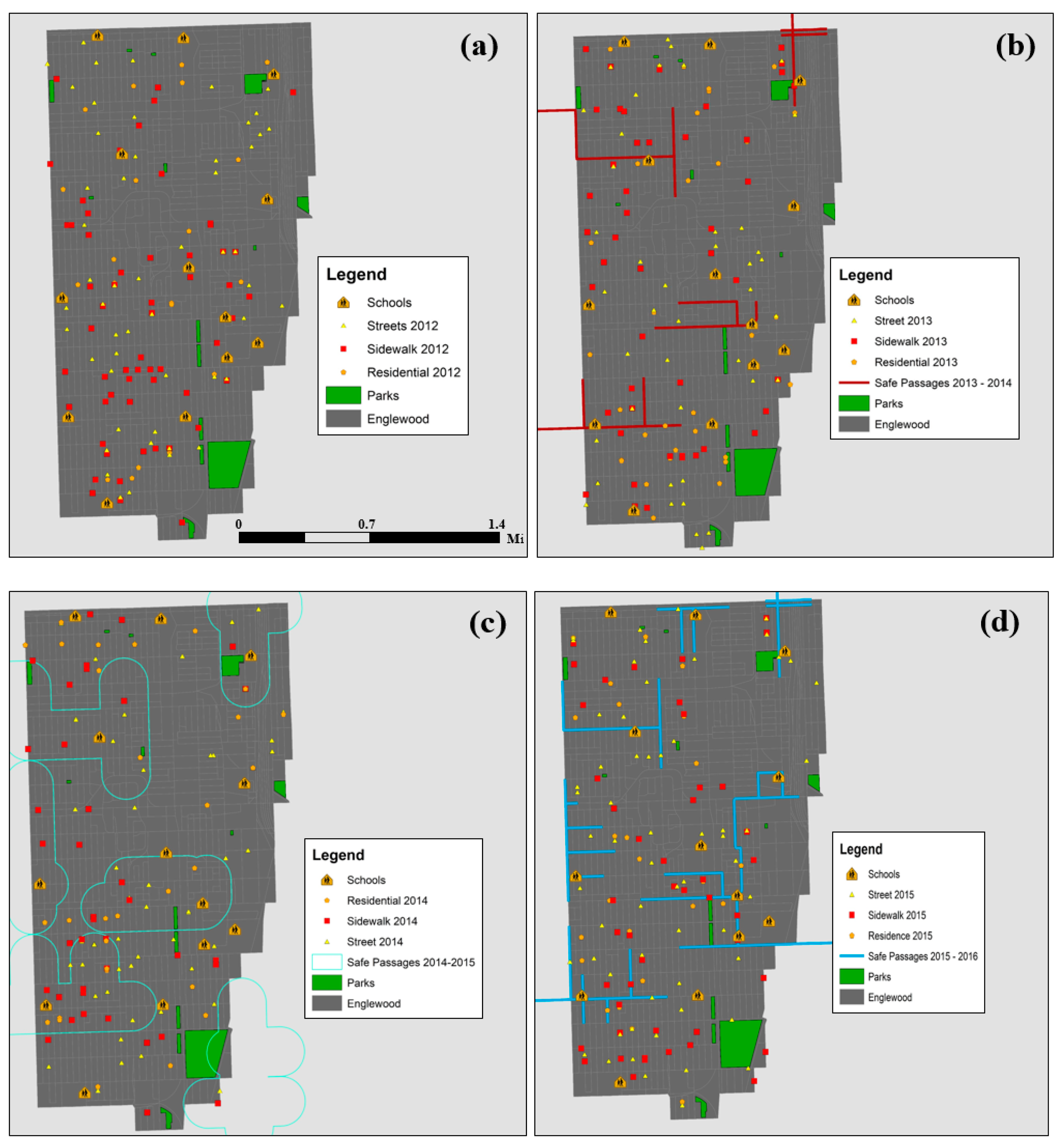
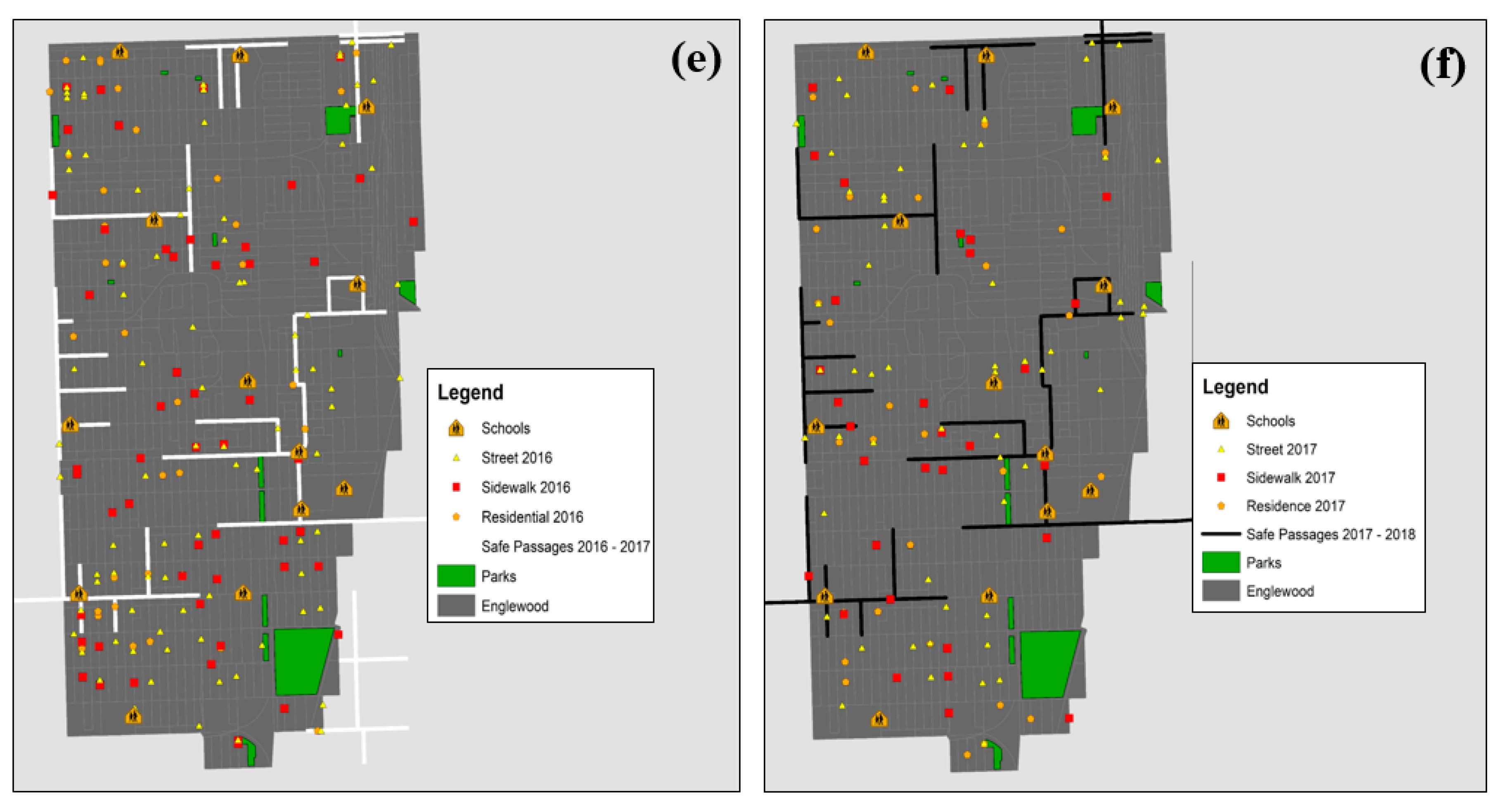
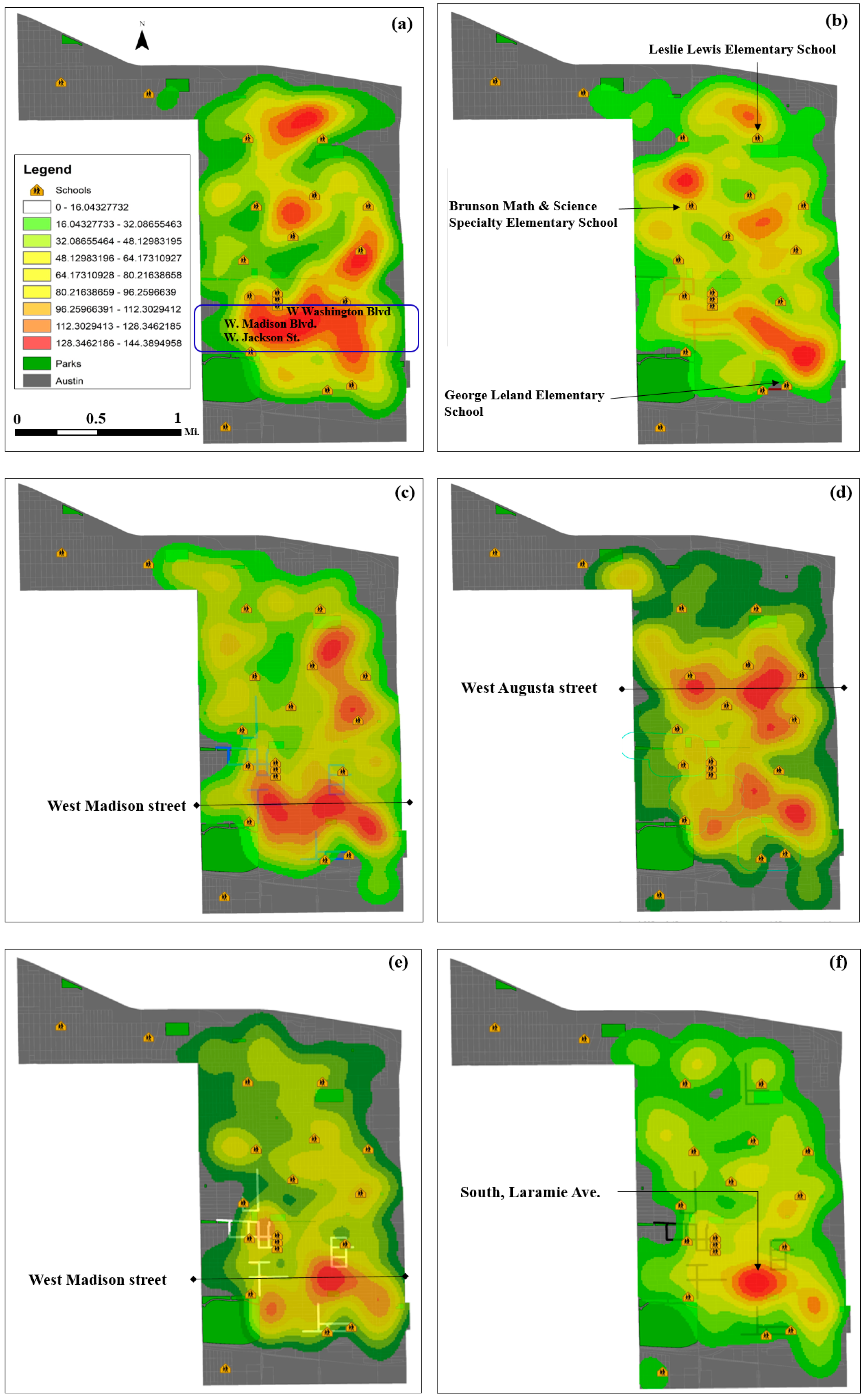
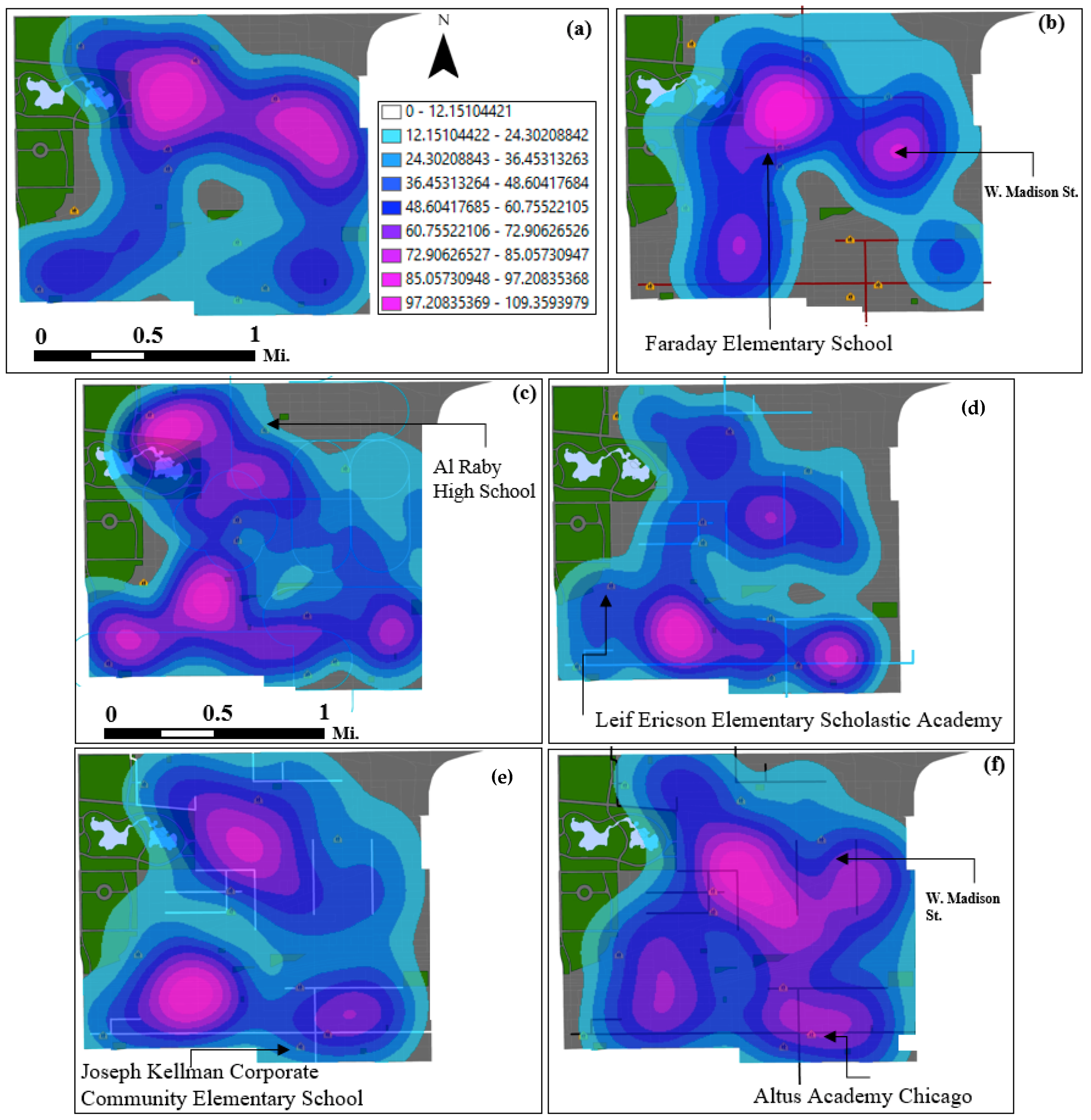
| Year | Chicago | Austin | East Garfield | North Lawndale | Englewood |
|---|---|---|---|---|---|
| 2013–2014 | 52 | 3 | 5 | 3 | 4 |
| 2014–2015 | 65 | 3 | 5 | 8 | 6 |
| 2015–2016 | 126 | 7 | 7 | 9 | 9 |
| 2016–2017 | 127 | 7 | 8 | 9 | 9 |
| 2017–2018 | 145 | 8 | 8 | 10 | 10 |
© 2019 by the author. Licensee MDPI, Basel, Switzerland. This article is an open access article distributed under the terms and conditions of the Creative Commons Attribution (CC BY) license (http://creativecommons.org/licenses/by/4.0/).
Share and Cite
Yang, B. GIS Crime Mapping to Support Evidence-Based Solutions Provided by Community-Based Organizations. Sustainability 2019, 11, 4889. https://doi.org/10.3390/su11184889
Yang B. GIS Crime Mapping to Support Evidence-Based Solutions Provided by Community-Based Organizations. Sustainability. 2019; 11(18):4889. https://doi.org/10.3390/su11184889
Chicago/Turabian StyleYang, Byungyun. 2019. "GIS Crime Mapping to Support Evidence-Based Solutions Provided by Community-Based Organizations" Sustainability 11, no. 18: 4889. https://doi.org/10.3390/su11184889
APA StyleYang, B. (2019). GIS Crime Mapping to Support Evidence-Based Solutions Provided by Community-Based Organizations. Sustainability, 11(18), 4889. https://doi.org/10.3390/su11184889


