Article

Estimating Stormwater Infiltration and Canopy Interception for Street Tree Pits in Manhattan, New York

by
Nandan Hara Shetty
Department of Civil and Environmental Engineering, The Citadel, 171 Moultrie Street, 208 LeTellier Hall, Charleston, SC 29409, USA
Forests 2023, 14(2), 216; https://doi.org/10.3390/f14020216
Submission received: 4 December 2022 / Revised: 7 January 2023 / Accepted: 17 January 2023 / Published: 23 January 2023
(This article belongs to the Special Issue Urban Forestry Measurements)

Abstract

:
Estimates of the amount of stormwater captured by urban trees have focused on the rainfall intercepted by leaves and branches, while the amount of stormwater runoff that flows into a tree pit from the surrounding sidewalk has not been well quantified. This study estimated the amount of stormwater that infiltrates into a tree pit by first calculating the tributary drainage area that drains to street tree pits of varying sidewalk widths and slopes. With Manhattan, New York, as a case study, the study used i-Tree software to find that for street trees in Manhattan, stormwater infiltration greatly exceeded canopy interception, by a ratio of 3 to 1: stormwater infiltration averaged 6842 L/yr, while canopy interception averaged 2228 L/yr. The results contradict prior research that asserted that canopy interception is the primary means by which street trees provide stormwater control. The study also provides a method to calculate street tree drainage areas that would improve estimates of the amount of stormwater captured by street trees, by highlighting the dominant role played by sidewalk widths and slopes. Infiltration averaged 4221 L/yr for a sidewalk width of 3 m and 14774 L/yr for a sidewalk width of 10 m. Infiltration also averaged 5607 L/yr for a street slope of 0.5% and 18,383 L/yr for a street slope of 10%.

1. Introduction

The year 2009 marked the first time that the majority of the world’s population lived in urban areas, a proportion expected to reach 68% by 2050 [1]. As urbanization intensifies, so will the amount of impermeable streets and sidewalks, which escalates stormwater runoff flows that degrade water quality in receiving waterbodies [2]. To combat this, cities are steadily turning to green infrastructure practices: “the range of measures that use plant or soil systems, permeable pavement or other permeable surfaces or substrates, stormwater harvest and reuse, or landscaping to store, infiltrate, or evapotranspirate stormwater and reduce flows to sewer systems or to surface waters” [3]. Street trees are increasingly viewed as an important component of a city stormwater management plan [4]. However, there is no standard estimate for the amount of stormwater captured by street trees and their canopy [5].
i-Tree is a free, publicly available software program developed by the United States Department of Agriculture Forest Service, and it is currently the leading program used by scientists and city-planners nationwide (and increasingly even internationally) to quantitatively estimate the benefits of urban trees [6,7,8,9,10,11,12,13]. Its estimates are largely based on annual canopy interception from the trees using measured tree species and tree diameter data [7,14]. Canopy interception is the storage of raindrops that fall on tree leaves and branches [15]. It is strongly influenced by both meteorological factors and tree characteristics [16]. Interception is greater during the early stages of a storm, and decreases after leaves become saturated with water [17]. A tree canopy may retain the first 2–4 mm of rainfall [18]. Interception is also greater during smaller storms that fall over a longer period of time, with greater time in between storms [17]. Interception can range from less than 10% of annual rainfall for deciduous trees in the rainy climate of Florida, USA, to more than 80% for conifers in the dry climate of Vancouver, Canada [18]. Interception can even vary for two species in the same genus, as Livesley et al. found two species of Eucalyptus had interception rates of 29% and 44% of annual rainfall [19]. Water that is not intercepted may drip from the canopy of trees as throughfall, or flow down the trunk to the ground as stemflow, which can represent up to 5% of the total rain [19]. The proportion of the total rain that flows as stemflow versus dripping via throughfall or stored via interception is highly variable [20], and changes between a tree’s leafed and leafless states [21]. Trees have less relative stemflow and greater relative throughfall, when compared to crops, shrubs, and grasses [22]. Trees also increase the amount of stormwater that infiltrates into the ground by root growth [17,23] and by reducing soil moisture through transpiration [5,18].
Such field studies upon which i-Tree estimates are based were mostly conducted at forest sites rather than urban areas [5]. Compared to trees in forested stands, street trees are often more isolated, with less competition for sunlight [18,19]. Street trees frequently have greater crown areas and leaf surface areas, which provide a larger storage area for intercepting rainfall [5,16]. Street trees are also frequently drought-stressed due to reduced infiltration from surrounding impervious surfaces, limited root volumes, soil compaction, and high evaporative demand [24]. The three types of street tree include trees planted in front lawns; those planted into a continuous lawn strip located between the curb and the sidewalk; and street tree pits, a type of street tree found in dense urban areas, where the sidewalk has been cut out and removed [25]. The urban tree with the greatest differences to its counterparts in a forest may be those planted within a street tree pit because they are surrounded by concrete sidewalk, much of which slopes directly into them, greatly affecting the amount of stormwater absorbed by the tree pit (Figure 1). This grading design is nearly universal in cities worldwide, with sidewalks that drain to the street, streets sloped so that they drain to the sidewalk, and a curbside gutter located where the sidewalk meets the street [26].
A street tree with a large sidewalk drainage area will receive greater stormwater inflows [27]. The amount of this inflow that infiltrates into the soil depends on the tree pits, soil properties, and weather characteristics. Plant root and insect activity tend to increase infiltration rates, while sediment deposition and soil compaction may decrease infiltration rates [28]. A tree pit will have greater infiltration if the soil is sandy [29] and high in organic matter [30,31]. Freeze–thaw cycles as well as alternating wet and dry periods tend to increase infiltration rates by increasing soil macroporosity [28]. Infiltration rates are greatest during small rain events, low-soil-moisture conditions, and warmer months of the year [32]. Warmer temperatures may increase infiltration because the viscosity of water decreases, enabling greater water movement [31]. Other reasons include the fact that increasing temperature causes the entrapped air in the soil to expand and, thus, decrease in volume [28], and there is increased evapotranspiration during warmer seasons, which may decrease soil moisture [33].
Measuring the area that drains onto a site is generally the first step in quantifying stormwater capture for green infrastructure practices such as rain gardens, permeable pavements, and rainwater-harvesting systems [34]. For street trees, however, the dimensions of sidewalk drainage areas and the volumes of stormwater runoff that drain from them into tree pits remain surprisingly unstudied (this is perhaps because traditional street trees often fall outside the innovative practices termed ‘green infrastructure’). For a street tree pit on a wide sidewalk, the sidewalk drainage area would be quite large, allowing the tree to capture and infiltrate substantial volumes of water. If the tree were also a small, young tree, it would have little leaf surface area to intercept water in its canopy, making canopy interception a smaller component of the water balance, in comparison to the vast volumes of stormwater that would flow into the tree pit from the sidewalk drainage area [23].
This would contradict the hypothesis put forth by Berland et al. that canopy interception is the primary means by which urban trees capture stormwater runoff [17]. To what extent then does stormwater infiltration into tree pits compare to canopy interception, as estimated by i-Tree? Better quantification may be the first step toward modifying street tree planting in ways that would increase future stormwater capture [4]. Improved research may also help justify public funds for tree planting and maintenance [35]. To respond to this need, this study compared stormwater infiltration and canopy interception for street trees. First, stormwater infiltration was estimated by calculating the amount of area that drains to street tree pits of varying sidewalk widths and slopes. Using Manhattan, New York, as a case study, sidewalk widths were measured to estimate sidewalk drainage areas. Annual infiltration volumes were calculated using the curve number method for all street trees in Manhattan. The study then used i-Tree to estimate canopy interception based on known tree diameters and tree species from a street tree census conducted in 2015 [36]. Finally, the study compared stormwater infiltration to canopy interception for different sidewalk widths, tree diameters, and tree species.

2. Materials and Methods

2.1. Manhattan as a Case Study

To determine typical sidewalk widths, the sidewalk widths for Manhattan were selected as a case study (Figure 2). Manhattan shares the cold Köppen–Geiger climate classification of the Northeastern U.S. but has hot summers (>22 °C) and no dry season [37]. The borough of Manhattan was selected rather than the entirety of New York City because 87% percent of Manhattan street trees are located in street tree pits (sidewalk cutouts), while, in contrast, 81% of street trees in the borough of Staten Island grow in front lawns or planting strips [38]. Staff at the New York City Department of Parks and Recreation estimated the sidewalk widths used in this study for 82% of the streets in Manhattan. In this estimate, 9% of streets in Manhattan had sidewalk widths less than 3 m, 56% between 3 and 5 m, 29% between 5 and 7 m, and 6% greater than 7 m. The median sidewalk width was 4.8 m. These and all data used in this study are available in the Supplementary Materials.

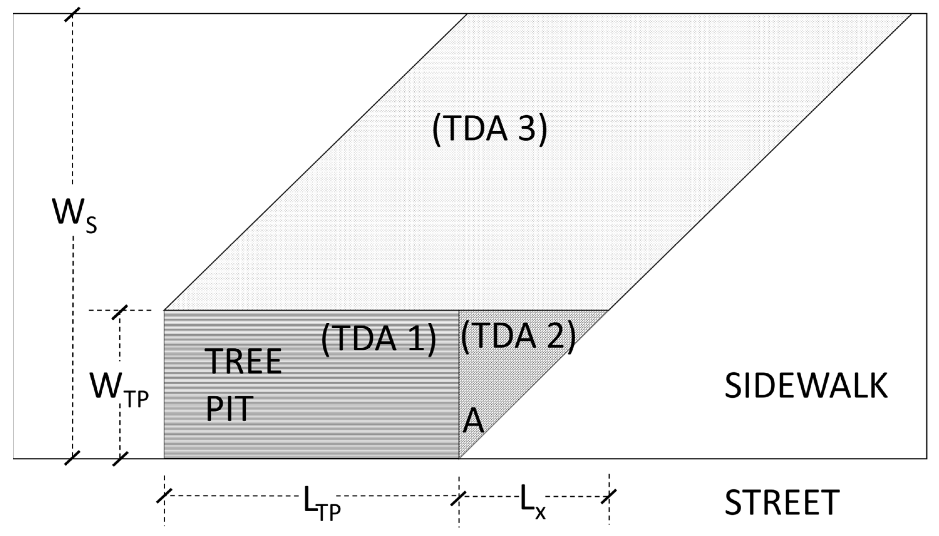
2.2. Tributary Area Delineation

Measuring the area that drains onto a site is the first step in quantifying stormwater capture for any green infrastructure practice. The NYC Department of Environmental Protection uses the term tributary drainage area (TDA; others use the term watershed area [33], catchment area [39,40], or drainage area [27,41]; these all refer to the same concept) to quantify the amount of surface area that drains to the green infrastructure practice [34]. In this study, the total TDA for each tree pit was calculated as the sum of three sub-areas: TDA 1, TDA 2, and TDA 3 (Figure 3). TDA 1, the tree pit itself, is a rectangle with a constant area:
TDA 1 = LTP ∗ WTP,
where LTP is the length of the tree pit and WTP is the width of the tree pit. For all new street trees in NYC, LTP is 3.05 m (10 ft) and WTP is 1.52 m (5 ft) [42]. TDA 1, thus, has a constant area of 4.65 m2 (1.52 m ∗ 3.05 m).
TDA 2 forms a triangle shape (Figure 3). The area of TDA 2 depends on WTP and length X (LX), which is based on WTP and A. A is an angle calculated from the transverse slope of the sidewalk from the property line to the street, ST, and the longitudinal slope down the length of the street, SL, both of which are typically in the range of 1.5% to 2% in New York City [42]:
A = Arctan (SL/ST),
Lx = WTP ∗ tan (A),
TDA   2 = W TP * L X 2 ,
TDA 3 forms a rhombus shape (Figure 3). The area of TDA 3 depends on LTP, LX, WTP, and the total width of the sidewalk, WS:
TDA 3 = (LTP + Lx) × (WS − WTP),
The total TDA for the tree pit is the sum of TDAs 1, 2, and 3.

2.3. Stormwater Infiltration

Stormwater infiltration into tree pits was estimated by mass balance through calculating runoff using TR-55, also known as the curve number method [43]. The curve number method is perhaps the most widely used approach to hydrology in the US [44]. It is commonly written as three equations:
R = ( P I a ) 2 P   I a + S ,
S = 25400 CN 254 ,
Ia = 0.2 (S),
where R is the estimated runoff depth (mm), P is the rainfall depth (mm), and Ia and S are intermediate values that denote initial abstraction and storage depths, respectively, that depend on the curve number (CN).
Using the standard land use table, a CN of 98 was selected to represent the impervious sidewalk tributary drainage area to the tree pits [43]. A CN of 70 was selected to represent uncompacted tree pits following Sanders’ pioneering study on the effects of trees on watershed hydrology [45]. A CN of 86 was selected to represent compacted tree pits following Sanders’ representation of bare soil. Finally, a CN of 98 (identical to sidewalks) was chosen to represent highly compacted tree pits for a decidedly conservative estimate of stormwater infiltration into tree pits that are nearly impermeable.
Equations (6)–(8) were applied to 40 years (March 1977–March 2017) of historical weather data from LaGuardia International Airport, downloaded from the National Oceanic and Atmospheric Administration’s National Climate Data Center website (www.ncdc.noaa.gov, accessed on 22 January 2023). This weather station was selected due to the availability of long-term rainfall data and its proximity to the study location. Hourly precipitation was separated out into individual storms using a minimum six-hour dry period [46,47]. For each of the 4121 total storms found over the 40 years, Equations (6)–(8) were used with a CN of 98 to estimate the stormwater entering into the tree pit from the impervious sidewalk (TDAs 2 and 3). This volume was divided by tree pit size to convert the runoff volume to a depth, which was then added to the rainfall depth to estimate the total inflow depth (rainfall + runoff) falling on or flowing into the tree pit. For each of these total inflow depths, Equations (6)–(8) were again used, this time with CNs of 70, 86, and 98 to estimate the stormwater runoff overflowing from a tree pit (TDA 1) that is uncompacted, compacted, and highly compacted, respectively. This overflow depth was subtracted from the inflow depth (rainfall + runoff) to estimate the stormwater infiltration per tree, and multiplied by the tree pit size to convert to a volume. Stormwater infiltration per tree was, thus, calculated as the difference between the volumes of stormwater entering and overflowing from the tree pits for all 4121 storms. Annual stormwater infiltration per tree was calculated by summing the infiltration for each storm for each of the 40 years for street slopes ranging from 0.5% to 10% and for sidewalk widths ranging from 3 m to 10 m.

2.4. Canopy Interception

Canopy interception was quantified by applying the latest version of i-Tree, i-Tree Eco, to Manhattan, New York. In the New York City Department of Parks and Recreation street tree census [36], 65,423 records were located in Manhattan. However, 3006 records contained information that could not be imported into i-Tree Eco, as they were either dead trees or missing tree species or DBH (diameter at breast height) information. Thus, 62,417 street tree records were imported into i-Tree Eco, using DBH and species information. A proportion of 82% of these street trees were located on streets on which the New York City Department of Parks and Recreation estimated the sidewalk width (Section 2.1). This resulted in 51,373 tree pits that were used for analysis. A total of 33% of these street trees had a DBH less than 15 cm, 43% between 15 and 30 cm, 22% between 30 and 60 cm, and 2% greater than 60 cm. The ten most common species were Gleditsia triacanthos (21% of all street trees), Pyrus calleryana (12%), Ginkgo biloba (9%), Quercus palustris (7%), Styphnolobium japonicum (7%), Platanus x acerifolia (7%), Zelkova serrata (6%), Tilia cordata (5%), Ulmus americana (3%), and Tilia americana (3%).
In addition to calculating the volume of water intercepted by a given tree’s canopy, i-Tree also calculates what it calls ‘avoided runoff,’ i.e., the amount of precipitation that would have turned into stormwater runoff, were it not for the tree’s presence. As i-Tree developers indicate, much runoff would be avoided even without trees, as the soil allows water to infiltrate into the ground [48]. Based on Hirabayashi’s work, the latest version of i-Tree assumes that 74.5% of the surface underneath the tree canopy is permeable and 25.5% is impermeable [49]. While these percentages were taken from Nowak and Greenfield’s study of urban areas in cities throughout the USA [50], they would not apply to street trees pits in dense urban areas, where street trees are frequently isolated among otherwise impermeable streets and sidewalks. Because this study focuses on street tree pits, where the tree canopy is largely over impervious surfaces, it would not be accurate to classify the area beneath the tree canopy as 74.5% permeable. Thus, i-Tree’s avoided runoff estimate (a mere fraction of the total canopy interception) is insufficient, and so this study does not present i-Tree’s avoided runoff estimate, but rather only presents the canopy interception estimate.
I-Tree Eco results for canopy interception were averaged after running the software using the weather station from LaGuardia International Airport for five years: 2019, 2018, 2014, 2011, and 2010. These years were selected because their average annual precipitation, 1406 mm, matches the long-term annual average precipitation for the same weather station from 1977 to 2017 used to estimate stormwater infiltration (Section 2.3).

3. Results

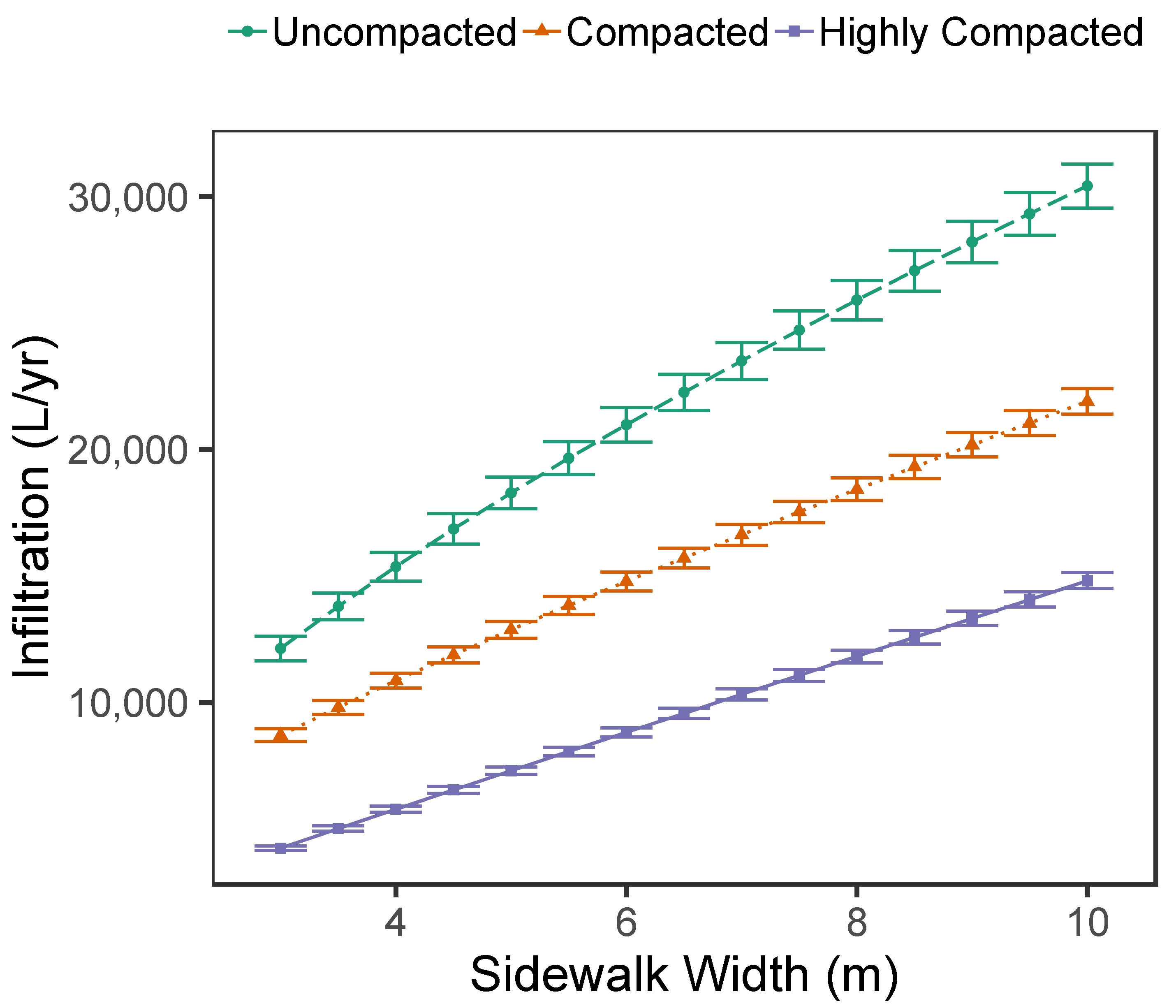
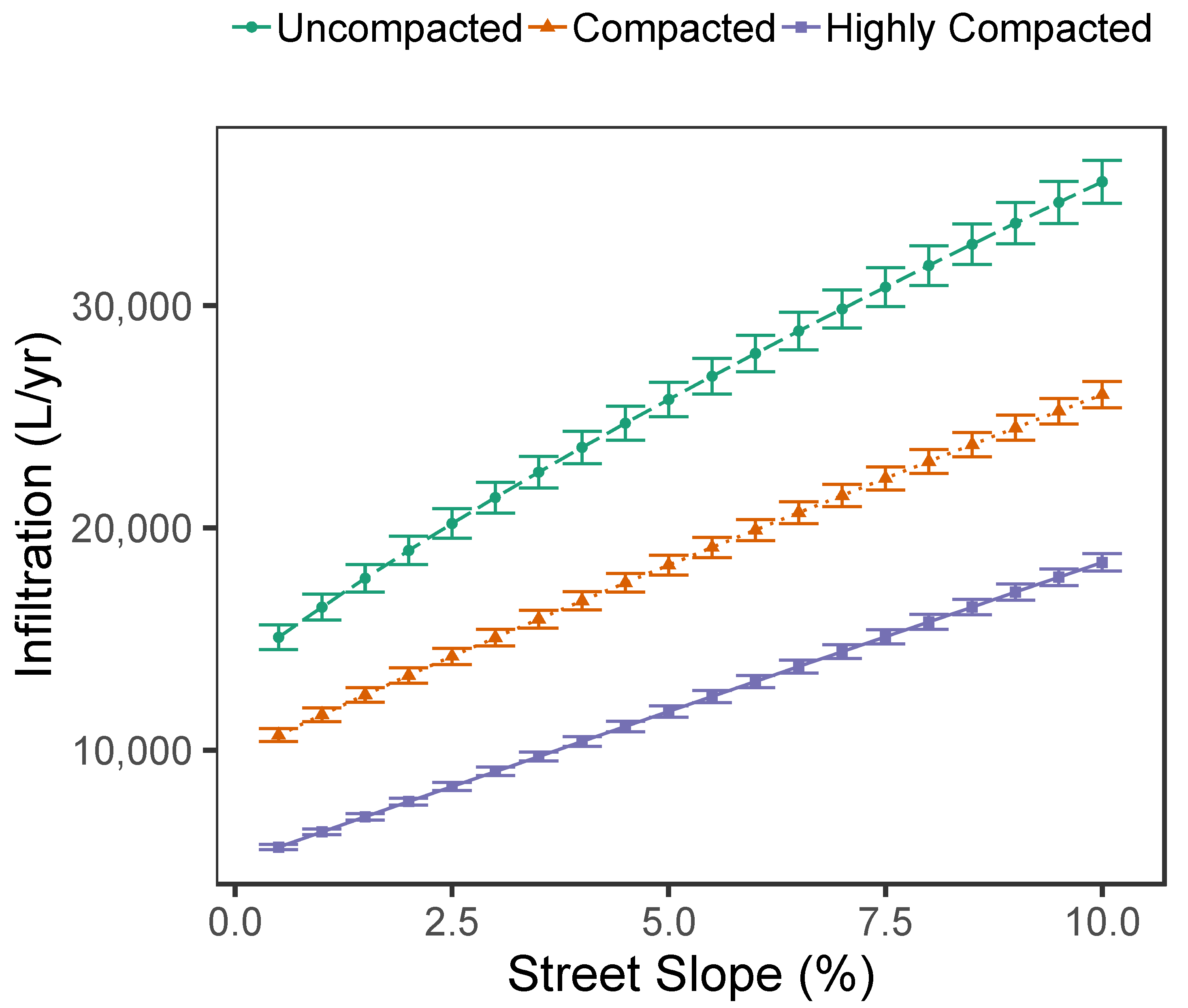
3.1. Estimates of Stormwater Infiltration into Sidewalk Tree Pits

Estimated infiltration increased dramatically as sidewalk width increased (Figure 4). For the most conservative estimate of infiltration (highly compacted tree pits (CN 98)), infiltration increased from a median of 4221 L/yr for a sidewalk width of 3 m to 14,774 L/yr for a sidewalk width of 10 m.
Estimated infiltration also increased as the longitudinal slope down the length of the street increased (Figure 5). Assuming the median sidewalk width for Manhattan (4.8 m), infiltration increased from a median of 5607 L/yr for a street slope of 0.5% to 18,393 L/yr for a street slope of 10% for the highly compacted scenario.

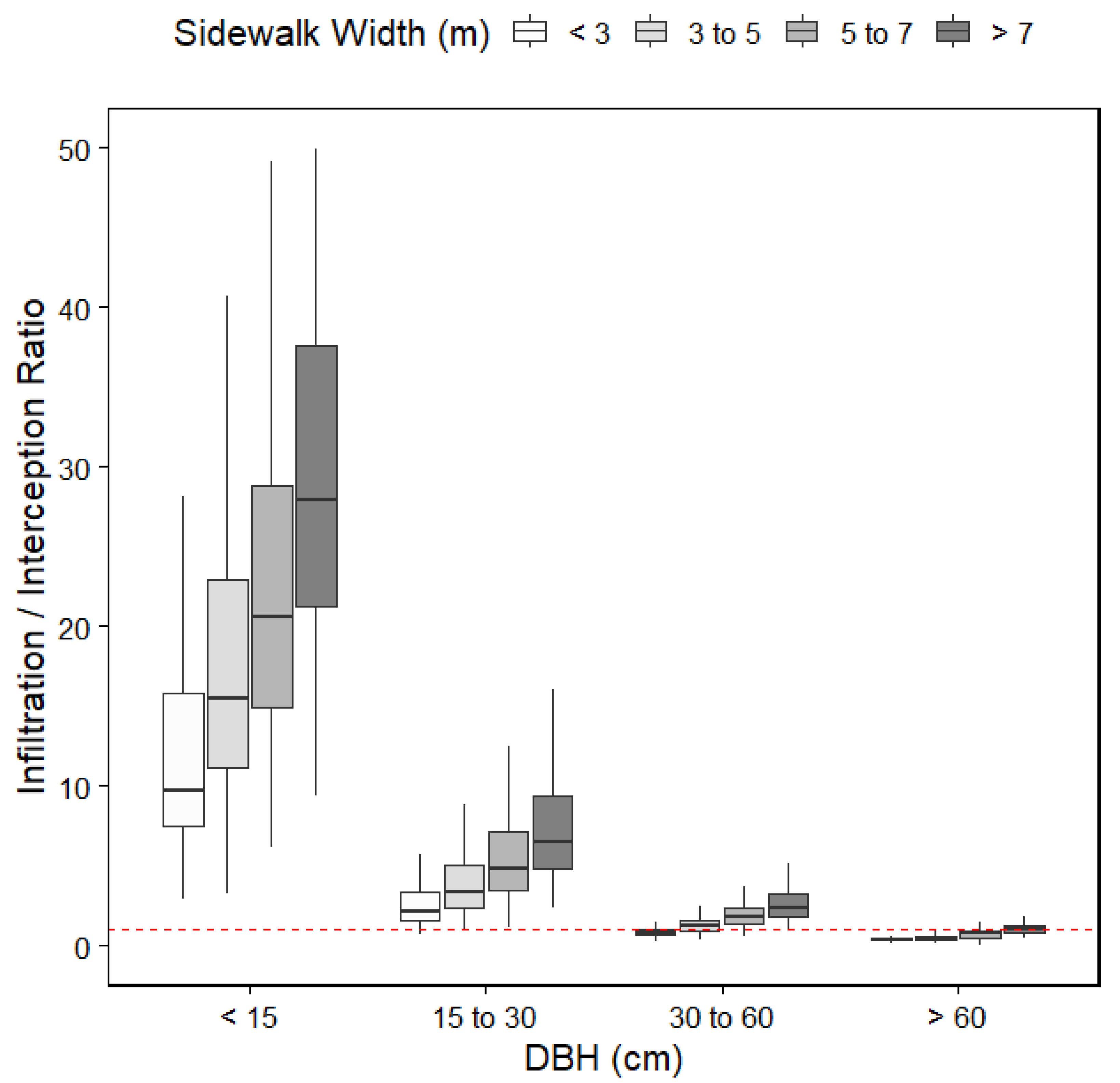
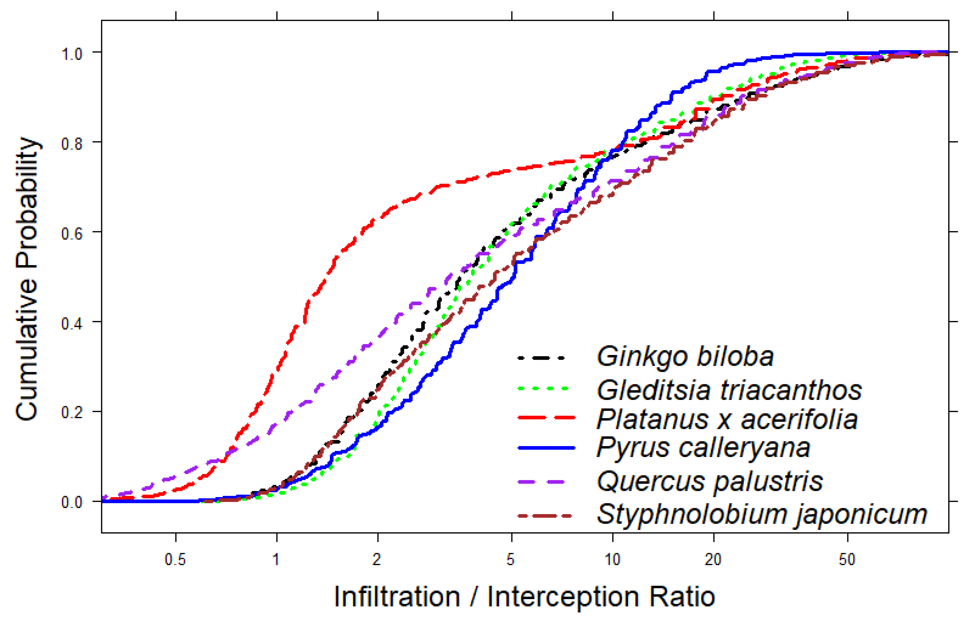
3.2. Comparing Infiltration to Canopy Interception

For stormwater capture overall, infiltration outperformed canopy interception by a ratio of 3 to 1. Based on actual sidewalk widths in Manhattan, the average per tree stormwater infiltration into tree pits as modeled by the curve number method assuming the highly compacted scenario (CN 98) was 6842 L/yr. In contrast, the average per tree canopy interception as modeled by i-Tree for Manhattan’s street trees was 2228 L/yr, based on tree species and DBH data. Infiltration exceeded canopy interception for most DBH and sidewalk width sizes in Manhattan (Figure 6). Infiltration exceeded interception for nearly all trees with a DBH less than 30 cm (that is, 76% of NYC’s street trees). For trees with a diameter between 30 and 60 cm (22% of NYC street trees), infiltration exceeded interception for most tree pits with sidewalk widths greater than 3 m. The only tree diameter category where infiltration was consistently less than canopy interception was for the largest trees, with a DBH greater than 60 cm (2% of NYC street trees).
Stormwater infiltration exceeded canopy interception for the six most common tree species in Manhattan based on their DBHs and sidewalk widths (Figure 7). For four of these species (Ginkgo biloba, Gleditsia triacanthos, Pyrus calleryana, and Styphnolobium japonicum), infiltration was less than interception (infiltration/interception ratio less than one) for approximately 2% of street trees (0.02 cumulative probability). Likewise, infiltration was roughly three to five times greater than canopy interception (infiltration/interception ratio greater than three to five) for the median tree (0.5 cumulative probability) of these four species. Platanus × acerifolia and Quercus palustris, however, had somewhat greater canopy interception, as infiltration was less than interception for approximately 30% and 20% of trees, respectively (0.3 and 0.2 cumulative probability, respectively). Infiltration was approximately one and half times greater than canopy interception for Platanus × acerifolia and three times greater for Quercus palustris for the median tree.

4. Discussion

4.1. Comparing Infiltration to Canopy Interception

This study found that stormwater infiltration exceeded canopy interception for most street tree pits in Manhattan (Figure 6 and Figure 7), by a ratio of 3 to 1. While the largest trees with a DBH greater than 60 cm admittedly had greater canopy interception than infiltration (Figure 6), these large trees only represent 2% of the street trees of Manhattan (Section 2.4). Even assuming that tree pits are highly compacted, conservative estimates of stormwater infiltration (narrow sidewalks and shallow street slopes) surpassed estimates of canopy interception (Figure 4 and Figure 5). This finding contradicts Berland et al., who hypothesized that canopy interception is the primary means by which street trees provide stormwater control [17]. This also contradicts Hirabayashi, whose models inform i-Tree Eco (see Section 2.4), who estimated total stormwater capture as a mere fraction of canopy interception [48].
Platanus × acerifolia and Quercus palustris were somewhat of an exception among street tree species, because a non-insignificant portion (30% and 20% respectively) of these species had greater estimated canopy interception than infiltration (Figure 7). This is because they tend to be large trees, underrepresented in the smaller DBH size groups in New York City [9]. Platanus × acerifolia, in particular, was planted heavily in the early 20th century and less frequently in recent decades, in New York City [38].

4.2. This Study Compared to Other Estimates of Street Tree Stormwater Capture

With New York City’s extensive dataset, this study used i-Tree in order to calculate the average per tree canopy interception for Manhattan’s street trees at 2228 L/yr. This is approximately consistent with others’ estimates of canopy interception using i-Tree, including Soares et al., who found that street trees in Lisbon, Portugal intercepted 4500 L/yr per tree [7]; Berland and Hopton, who estimated annual interception at 6700 L per tree for street trees in Cincinnati, Ohio [14]; McPherson et al., who found that street trees in cities of California, USA annually intercepted 2870 L/yr per tree [51]. It is also consistent with the 1800, 3200, and 6600 L/yr estimated to be intercepted per tree by street trees in Sacramento County, Modesto, and Santa Monica, California, respectively, using the original rainfall interception model developed by Xiao and McPherson that informed the earliest versions of the i-Tree software [16]. Estimates are also in line with the 6376 L/yr per tree directly measured in a paired catchment experimental monitoring design by Selbig et al. in a residential neighborhood of Wisconsin, USA, where 31 mature street trees (DBH ranged from 40 to 56 cm) were removed from a street-side lawn strip [5].
No studies have yet quantified stormwater infiltration into street tree pits from surrounding sidewalks. However, Armson et al. did note that the lack of seasonal difference in stormwater capture for their experimental study of nine plots of Acer campestre, despite the deciduous trees losing their leaves over the winter season, was likely because the majority of stormwater capture was due to infiltration rather than canopy interception [23]. As they were studying trees younger than 10 years old, this confirms our finding that for smaller street trees, with DBH less than 30 cm, infiltration in fact greatly exceeds canopy interception.

5. Conclusions

This study provides a method to determine the TDA for a street tree pit, which allows the calculation of stormwater infiltration volumes. Its findings hold many important implications for city land managers, particularly that street tree planting should be modified to increase stormwater capture [4]. In neighborhoods where excess stormwater runoff poses the most severe water quality and/or flooding problems, tree planting should be prioritized for streets with significant slopes and wide sidewalks, because trees on these streets have large TDAs, and will, therefore, capture and infiltrate significant volumes of stormwater runoff. These trees could also be targeted for measures that increase their stormwater capture, such as the incorporation of a drainage layer, or an expanded pit size. However, consideration must be given such that these trees do not become waterlogged [23]. This could be achieved by ensuring that they are planted with a ponding depth sufficiently shallow to ensure drainage yet sufficiently deep to encourage infiltration, as specified for other types of green infrastructure, such as rain gardens [32]. Unfortunately, street trees are often grown in convex or mounded pits that impede stormwater capture [17].
Street tree planting should also be modified to improve tree health and survival. Given that street trees typically experience high levels of drought stress [24], particularly drought-intolerant tree species should be planted on streets with large TDAs. This is because the tree species that are most vulnerable to drought stress would benefit most from greater stormwater infiltration volumes. Conversely, drought-tolerant tree species should be specified for streets with narrow sidewalks and shallow slopes, because such hardy tree species may thrive despite limited stormwater flowing in from surrounding sidewalks. In cold climates where de-icing salts are applied to sidewalks, trees located on streets with large TDAs should also be salt-tolerant, as salt levels in urban green infrastructure soil can remain elevated throughout the growing season [52].
This study was limited, however, because it focused on stormwater infiltration alone. While prior studies studied canopy interception alone and omitted stormwater infiltration from surrounding sidewalks, this study on the other hand estimated stormwater infiltration without quantifying the amount of stormwater that would have been intercepted by leaves and branches in the tree’s canopy before falling into the tree pit’s TDAs. Future estimates must calculate stormwater infiltration and canopy interception together to accurately estimate the total stormwater capture attributable to a street tree. To do this, the three TDAs used in this study must be modified to include the percentage area that is under canopy cover. These percentages will vary based on the tree species, DBH, street slope, and sidewalk width. In addition, a fourth TDA will need to be quantified for canopy area downstream of the tree pit. This fourth TDA will include tree canopy area that intercepts rainfall but does not drip into the three TDAs quantified in this study.

Supplementary Materials

Supporting information can be downloaded at: https://www.mdpi.com/article/10.3390/f14020216/s1.

Funding

This research received no external funding.

Data Availability Statement

The data presented in this study are available in the Supplementary Materials.

Acknowledgments

The author wishes to thank the New York City Department of Parks and Recreation for supporting this work and for conducting street tree censuses, and, in particular, Christopher Bride from the Central Forestry, Horticulture, and Natural Resources division for developing a method to estimate sidewalk widths for all streets in New York City.

Conflicts of Interest

The author declares no conflict of interest.

References

  1. UN. 2018 Revision of World Urbanization Prospects. 2018. Available online: https://www.un.org/development/desa/publications/2018-revision-of-world-urbanization-prospects.html (accessed on 22 January 2023).
  2. Mcgrane, S.J. Impacts of urbanisation on hydrological and water quality dynamics, and urban water management: A review water management: A review. Hydrol. Sci. J. 2016, 61, 2295–2311. [Google Scholar] [CrossRef] [Green Version]
  3. United States Environmental Protection Agency. What is Green Infrastructure? 2022. Available online: https://www.epa.gov/green-infrastructure/what-green-infrastructure (accessed on 22 January 2023).
  4. McPherson, G.; Simpson, J.R.; Peper, P.J.; Maco, S.E.; Xiao, Q. Municipal forest benefits and costs in five US cities. J. For. 2005, 103, 411–416. [Google Scholar]
  5. Selbig, W.R.; Loheide, S.P.; Shuster, W.; Scharenbroch, B.C.; Coville, R.C.; Kruegler, J.; Avery, W.; Haefner, R.; Nowak, D. Quantifying the stormwater runoff volume reduction benefits of urban street tree canopy. Sci. Total Environ. 2022, 806, 151296. [Google Scholar] [CrossRef] [PubMed]
  6. Nyelele, C.; Kroll, C.N.; Nowak, D.J. Present and future ecosystem services of trees in the Bronx, NY. Urban For. Urban Green 2019, 42, 10–20. [Google Scholar] [CrossRef]
  7. Soares, A.L.; Rego, F.C.; McPherson, E.G.; Simpson, J.R.; Peper, P.J.; Xiao, Q. Benefits and costs of street trees in Lisbon, Portugal. Urban For. Urban Green. 2011, 10, 69–78. [Google Scholar] [CrossRef]
  8. Bautista, D.; Peña-Guzmán, C. Simulating the hydrological impact of green roof use and an increase in green areas in an urban catchment with i-tree: A case study with the town of Fontibón in Bogotá, Colombia. Resources 2019, 8, 68. [Google Scholar] [CrossRef] [Green Version]
  9. Nowak, D.J.; Bodine, A.R.; Hoehn Robert, E.I.; Ellis, A.; Hirabayashi, S.; Coville, R.; Auyeung, D.N.; Sonti, N.F.; Hallett, R.A.; Johnson, M.L.; et al. The Urban Forest of New York City; U.S. Department of Agriculture, Forest Service, Northern Research Station: Madison, WI, USA, 2018; 117, p. 82. [CrossRef] [Green Version]
  10. Kirnbauer, M.C.; Baetz, B.W.; Kenney, W.A. Estimating the stormwater attenuation benefits derived from planting four monoculture species of deciduous trees on vacant and underutilized urban land parcels. Urban For. Urban Green 2013, 12, 401–407. [Google Scholar] [CrossRef]
  11. Song, P.; Guo, J.; Xu, E.; Mayer, A.L.; Liu, C.; Huang, J.; Tian, G.; Kim, G. Hydrological effects of urban green space on stormwater runoff reduction in Luohe, China. Sustainablity 2020, 12, 6599. [Google Scholar] [CrossRef]
  12. Hilde, T.; Paterson, R. Integrating ecosystem services analysis into scenario planning practice: Accounting for street tree benefits with i-Tree valuation in Central Texas. J Environ Manage. 2014, 146, 524–534. [Google Scholar] [CrossRef]
  13. Tan, X.; Hirabayashi, S.; Shibata, S. Estimation of ecosystem services provided by street trees in Kyoto, Japan. Forests 2021, 12, 311. [Google Scholar] [CrossRef]
  14. Berland, A.; Hopton, M.E. Comparing street tree assemblages and associated stormwater benefits among communities in metropolitan Cincinnati, Ohio, USA. Urban For. Urban Green 2014, 13, 734–741. [Google Scholar] [CrossRef]
  15. Seitz, J.; Escobedo, F. Urban Forests in Florida: Trees Control Stormwater Runoff and Improve Water Quality. Edis 2008, 2008, 1–4. [Google Scholar] [CrossRef]
  16. Xiao, Q.; McPherson, E.G. Rainfall interception by Santa Monica’s municipal urban forest. Urban Ecosyst. 2002, 6, 291–302. [Google Scholar] [CrossRef]
  17. Berland, A.; Shiflett, S.A.; Shuster, W.D.; Garmestani, A.S.; Goddard, H.C.; Herrmann, D.L.; Hopton, M.E. The role of trees in urban stormwater management. Landsc. Urban Plan 2017, 162, 167–177. [Google Scholar] [CrossRef] [Green Version]
  18. Kuehler, E.; Hathaway, J.; Tirpak, A. Quantifying the benefits of urban forest systems as a component of the green infrastructure stormwater treatment network. Ecohydrology 2017, 10, e1813. [Google Scholar] [CrossRef]
  19. Livesley, S.J.; Baudinette, B.; Glover, D. Rainfall interception and stem flow by eucalypt street trees—The impacts of canopy density and bark type. Urban For. Urban Green 2014, 13, 192–197. [Google Scholar] [CrossRef]
  20. Sadeghi, S.M.M.; Attarod, P.; Van Stan, J.T.; Pypker, T.G. The importance of considering rainfall partitioning in afforestation initiatives in semiarid climates: A comparison of common planted tree species in Tehran, Iran. Sci. Total Environ. 2016, 568, 845–855. [Google Scholar] [CrossRef]
  21. Sadeghi, S.M.M.; Van Stan, J.T.; Pypker, T.G.; Tamjidi, J.; Friesen, J.; Farahnaklangroudi, M. Importance of transitional leaf states in canopy rainfall partitioning dynamics. Eur. J. For. Res. 2018, 137, 121–130. [Google Scholar] [CrossRef]
  22. Sadeghi, S.M.M.; Gordon, D.A.; Van Stan, J.T. A Global Synthesis of Throughfall and Stemflow Hydrometeorology. In Precipitation Partitioning by Vegetation: A Global Synthesis; Springer: Cham, Switzerland, 2020; pp. 49–70. [Google Scholar]
  23. Armson, D.; Stringer, P.; Ennos, A.R. The effect of street trees and amenity grass on urban surface water runoff in Manchester, UK. Urban For. Urban Green 2013, 12, 282–286. [Google Scholar] [CrossRef]
  24. Szota, C.; Coutts, A.M.; Thom, J.K.; Virahsawmy, H.K.; Fletcher, T.D.; Livesley, S.J. Street tree stormwater control measures can reduce runoff but may not benefit established trees. Landsc. Urban Plan. 2019, 182, 144–155. [Google Scholar] [CrossRef]
  25. Lu, J.W.T.; Svendsen, E.S.; Campbell, L.K.; Greenfeld, J.; Braden, J.; King, K.L.; Falxa-Raymond, N. Biological, Social, and Urban Design Factors Affecting Young Street Tree Mortality in New York City. Cities Environ. 2010, 3, 1–15. [Google Scholar] [CrossRef]
  26. Mays, L.W. Water Resources Engineering, 2nd ed.; John Wiley & Sons: Hoboken, NJ, USA, 2011. [Google Scholar]
  27. Davis, A.P.; Traver, R.G.; Hunt, W.F.; Lee, R.; Brown, R.A.; Olszewski, J.M. Hydrologic Performance of Bioretention Stormwater Control Measures. J. Hydrol. Eng. 2012, 17, 604–614. [Google Scholar] [CrossRef]
  28. Ebrahimian, A.; Sample-Lord, K.; Wadzuk, B.; Traver, R. Temporal and spatial variation of infiltration in urban green infrastructure. Hydrol. Process. 2020, 34, 1016–1034. [Google Scholar] [CrossRef]
  29. Hunt, W.F.; Davis, A.P.; Traver, R.G. Meeting hydrologic and water quality goals through targeted bioretention design. J. Environ. Eng. 2012, 138, 698–707. [Google Scholar] [CrossRef]
  30. Turk, R.L.; Kraus, H.T.; Bilderback, T.E.; Hunt, W.F.; Fonteno, W.C. Rain garden filter bed substrates affect stormwater nutrient remediation. HortScience 2014, 49, 645–652. [Google Scholar] [CrossRef]
  31. Emerson, C.H.; Traver, R.G. Multiyear and seasonal variation of infiltration from stormwater best management practices. J. Irrig. Drain. Eng. 2008, 134, 598–605. [Google Scholar] [CrossRef]
  32. Davis, A.P.; Hunt, W.F.; Traver, R.G.; Clar, M. Bioretention technology: Overview of current practice and future needs. J. Environ. Eng. 2009, 135, 109–117. [Google Scholar] [CrossRef]
  33. Hunt, W.F.; Jarrett, A.R.; Smith, J.T.; Sharkey, L.J. Evaluating bioretention hydrology and nutrient removal at three field sites in North Carolina. J. Irrig. Drain. Eng. 2006, 132, 600–608. [Google Scholar] [CrossRef]
  34. NYC Green Infrastructure: On-site Design Manual. New York City. 2021. Available online: https://www1.nyc.gov/assets/dep/downloads/pdf/water/stormwater/green-infrastructure/nyc-green-infrastructure-onsite-design-manual-v2.pdf (accessed on 22 January 2023).
  35. Pincetl, S.; Gillespie, T.; Pataki, D.E.; Saatchi, S.; Saphores, J.D. Urban tree planting programs, function or fashion? Los Angeles and urban tree planting campaigns. GeoJournal 2013, 78, 475–493. [Google Scholar] [CrossRef]
  36. City of New York. 2015 Street Tree Census—Tree Data. In Department of Parks and Recreation (DPR) [Internet]. 2022. Available online: https://data.cityofnewyork.us/Environment/2015-Street-Tree-Census-Tree-Data/uvpi-gqnh (accessed on 15 August 2022).
  37. Peel, M.; Finlayson, B.L.; McMahon, T.A. Updated world map of the Koppen-Geiger climate classification. Hydrol. Earth Syst. Sci. 2007, 11, 1633–1644. [Google Scholar] [CrossRef]
  38. Peper, P.; McPherson, E.G.; Simpson, J.R.; Gardner, S.; Vargas, K.; Xiao, Q. New York City, New York: Municipal Forest Resource Analysis; U.S. Department of Agriculture: Davis, CA, USA, 2007.
  39. Hatt, B.E.; Fletcher, T.D.; Deletic, A. Hydrologic and pollutant removal performance of stormwater biofiltration systems at the field scale. J. Hydrol. 2009, 365, 310–321. [Google Scholar] [CrossRef]
  40. Bratieres, K.; Fletcher, T.D.; Deletic, A.; Zinger, Y. Nutrient and sediment removal by stormwater biofilters: A large-scale design optimisation study. Water Res. 2008, 42, 3930–3940. [Google Scholar] [CrossRef]
  41. Roy-Poirier, A.; Champagne, P.; Filion, Y. Review of bioretention system research and design: Past, present, and future. J. Environ. Eng. 2010, 136, 878–889. [Google Scholar] [CrossRef]
  42. NYCDOT Street Design Manual. 2022. Available online: https://www.nycstreetdesign.info/ (accessed on 22 January 2023).
  43. NRCS Urban Hydrology for Small Watersheds TR-55. USDA Nat Resour Conserv Serv Conserv Engeneering Div Tech Release 55. 1986, 164. Technical Release 55. Available online: https://www.hydrocad.net/pdf/TR-55%20Manual.pdf (accessed on 22 January 2023).
  44. Ponce, V.M.; Hawkins, R.H. Runoff Curve Number: Has It Reached Maturity? J. Hydrol. Eng. 1996, 1, 11–19. [Google Scholar] [CrossRef]
  45. Sanders, R.A. Urban vegetation impacts on the hydrology of Dayton, Ohio. Urban Ecol. 1986, 9, 361–376. [Google Scholar] [CrossRef]
  46. Carson, T.B.; Marasco, D.E.; Culligan, P.J.; McGillis, W.R. Hydrological performance of extensive green roofs in New York City: Observations and multi-year modeling of three full-scale systems. Environ. Res. Lett. 2013, 8, 024036. [Google Scholar] [CrossRef]
  47. Berretta, C.; Poe¨, S.; Stovin, V. Moisture content behaviour in extensive green roofs during dry periods: The influence of vegetation and substrate characteristics. J. Hydrol. 2014, 511, 374–386. [Google Scholar] [CrossRef]
  48. Hirabayashi, S.; i-Tree Streets/Design/Eco Rainfall Interception Model Comparisons. I-Tree Tools. 2013, pp. 1–8. Available online: https://www.itreetools.org/eco/resources/iTree_Streets_Design_Eco_Rainfall_Interception_Model_Comparisons.pdf (accessed on 22 January 2023).
  49. Hirabayashi, S. i-Tree Eco Precipitation Interception Model Descriptions; US Department of Agriculture Forest Service: Washington, DC, USA, 2013; p. 21. Available online: https://www.itreetools.org/eco/resources/iTree_Eco_Precipitation_Interception_Model_Descriptions.pdf (accessed on 22 January 2023).
  50. Nowak, D.J.; Greenfield, E.J. Tree and impervious cover change in U.S. cities. Urban For. Urban Green 2012, 11, 21–30. [Google Scholar] [CrossRef] [Green Version]
  51. McPherson, E.G.; van Doorn, N.; de Goede, J. Structure, function and value of street trees in California, USA. Urban For Urban Green 2016, 17, 104–115. [Google Scholar] [CrossRef] [Green Version]
  52. Shetty, N.H.; Mailloux, B.J.; Mcgillis, W.R.; Culligan, P.J. Science of the Total Environment Observations of the seasonal buildup and washout of salts in urban bioswale soil. Sci. Total Environ. 2020, 722, 137834. [Google Scholar] [CrossRef]
Figure 1. The tributary drainage area for a street tree pit includes sidewalk sloped into the tree pit.
Forests 14 00216 g001
Figure 2. Estimated sidewalk widths in an area of Manhattan, New York.
Forests 14 00216 g002
Figure 3. The tributary drainage area (TDA) for a street tree pit can be subdivided into three separate drainage areas: TDA 1, TDA 2, and TDA 3. LTP and WTP are the length and width of the tree pit, respectively, WS is the total width of the sidewalk, and LX and A are the length and angle, respectively, whose dimensions depend on the slopes of the sidewalk and street, and are required to calculate the areas of TDA 2 and TDA 3.
Forests 14 00216 g003
Figure 4. Estimated stormwater infiltration into tree pits for different sidewalk widths assuming that the transverse slope of the sidewalk and the longitudinal slope down the length of the street are equivalent (1.5%). Uncompacted, compacted, and highly compacted tree pits were simulated using a curve number of 70, 86, and 98, respectively.
Forests 14 00216 g004
Figure 5. Estimated stormwater infiltration into tree pits for different longitudinal slopes down the length of the street, assuming the median sidewalk width for Manhattan (4.8 m), and a typical transverse slope of the sidewalk of 1.5%. Uncompacted, compacted, and highly compacted tree pits were simulated using a curve number of 70, 86, and 98, respectively.
Forests 14 00216 g005
Figure 6. Ratio of stormwater infiltration into tree pits and canopy interception for various diameters at breast height (DBH) and sidewalk widths. Dotted line denotes a 1:1 ratio.
Forests 14 00216 g006
Figure 7. Cumulative probability of the stormwater infiltration/canopy interception ratio for the six most common street tree species in Manhattan, New York.
Forests 14 00216 g007
Disclaimer/Publisher’s Note: The statements, opinions and data contained in all publications are solely those of the individual author(s) and contributor(s) and not of MDPI and/or the editor(s). MDPI and/or the editor(s) disclaim responsibility for any injury to people or property resulting from any ideas, methods, instructions or products referred to in the content.

