Article

Forest Surface Changes and Cultural Values: The Forests of Tuscany (Italy) in the Last Century

Department of Agriculture, Food, Environment and Forestry (DAGRI), University of Florence, Via San Bonaventura 13, 50145 Florence, Italy
*
Author to whom correspondence should be addressed.
Forests 2021, 12(5), 531; https://doi.org/10.3390/f12050531
Submission received: 7 April 2021 / Revised: 20 April 2021 / Accepted: 23 April 2021 / Published: 25 April 2021
(This article belongs to the Special Issue Innovation Strategies and Their Impact on Forest Policy)

Abstract

:
Despite the definition of social and cultural values as the third pillar of Sustainable Forest Management (SFM) in 2003 and the guidelines for their implementation in SFM in 2007 issued by the Ministerial Conference on the Protection of Forest in Europe (MCPFE), the importance of cultural values is not sufficiently transferred into forest planning and conservation. Tuscany is widely known for the quality of its cultural landscape, however, the abandonment of agro-pastoral surfaces as a consequence of rural areas depopulation, has led to widespread reforestation and to the abandonment of forest management. In addition, due to the interruption of a regular forest management and to the fact that most of the population lives in cities, forests are no more perceived as part of the cultural heritage, but mainly as a natural landscape. Due to this trend traditional forest management techniques, such as coppicing, have also been considered as a factor of degradation and not even a historical management form. The aim of the study is therefore to analyze forest surface changes in Tuscany in the last century to assess the importance of cultural values. Results highlighted that already in 1881 most of forests were regularly managed and that in 1936 more than 76% of broadleaved forests were managed as coppice. Between 1936 and 2016 forests increased their surface from 876,518 to 1,161,383 hectares due to the abandonment of the countryside, and 30% of the forests currently included in protected areas are the result of secondary successions. The findings of this study suggest the revision of national forest policies and, more in general, the adaptation of forest strategies to local conditions.

1. Introduction

Human activities are usually perceived as an agent of degradation in relation to forests denying the values associated to an active management of forests. However, in the last few years there is a recognition that the human activities, especially the traditional ones, can have positive effects [1]. In 2003, the Ministerial Conference on the Protection of Forest in Europe (MCPFE) introduced social and cultural values in sustainable forest management (SFM) [2], while in 2007 the Guidelines for the Implementation of Social and Cultural Values in SFM were also produced [3]. Forest-related traditional knowledge is increasingly considered a key factor in sustainable forest management [4] as also in the preservation of biodiversity [5]. It is in fact proved that some types of forests with high levels of biodiversity can survive only if they are regularly managed applying traditional knowledge developed through the centuries. For example, chestnut orchards, a forest type with deep roots into the history and culture of many European mountains, still preserve monumental trees and are characterized by higher levels of biodiversity compared to the “natural” forest that grows after their abandonment, providing habitats for wild flora and fauna species, including different species of bats and invertebrates [6,7].
The increasing attention at international level to the role of cultural landscapes as examples of good practices and multifunctionality demonstrated by policies and strategies testifies a significant change in the perception of cultural values related to the environment [8]. Moreover, from the 1990s, it has been recognized that the combination of local communities’ forest-related traditional knowledge and formal forestry scholars could be successful for a sustainable forest management [1,9].
Similarly, the term “biocultural diversity” highlights the indissoluble link between biological diversity and cultural diversity, a term that comes from the field of social sciences that deals with the relationships between human knowledge and techniques, and the environment [10]. The biocultural diversity is also the subject of a joint programme by UNESCO and CBD (Convention on Biological Diversity) [11,12] that point out the role of cultural values in shaping and preserving rural landscapes [13]. Moreover, the GIAHS (Globally Important Agricultural Heritage Systems) programme launched by FAO (Food and Agricultural Organization), aims to identify and preserve agricultural systems of global importance resulting from the adaptation of traditional agro-silvo-pastoral practices to different environment [14,15]. This programme takes in high regard traditional knowledge, cultural values and the role of local communities in relation to agro-biodiversity and landscape and has included some cultural forests among the sites inscribed in the programme, although there are no specific selection criteria for them [14,15].
Forests are a fundamental feature of many European cultural landscapes, capable of providing many ecosystem services [16,17,18,19,20] beside wood production, especially in relation to water regulation and soil protection [21], biological diversity [22], human health and wellbeing [23,24,25]. In addition, Mediterranean areas host an especially high diversity and endemism, rendering them an ideal stage for biodiversity, biogeographical and cultural studies [17,26,27,28,29,30,31], as well as for landscape and vegetational related studies, also thanks to the availability of historical documents and toponyms [32,33]. Unfortunately, despite this wide recognition at scientific and institutional level of the multifunctional role of forests and of the importance of cultural values for forest sustainable management, their role in forest planning and management is today still underrated, especially when considering the origin of many forests, also the ones included into protected areas [8,34,35]. Moreover, both the EU Forest Action Plan and the European Green Deal do not even mention this topic although many European forests, from Scandinavia to Italy, show cultural features, although with a different level of human influence [36,37].
In Italy, forests currently occupy about 39% of the total surface, while Tuscany is one of the first two regions in terms of surface occupied by forests, covering about 1,163,057 ha, equal to 50.6% of the regional territory [38]. Tuscany is the fifth Italian region in terms of extension, with 67% of the territory classified as hills, 25% as mountains (mostly in the Apennine range) and only 8% as plains [39]. The 93% of the regional territory is classified as rural, while 44% of the population (3,753,000 people) lives in 11% of the territory characterized by intensive landscapes [40]. Tuscany has also a long history, with the first stable settlements dating back long before the Roman Empire, of interactions between forests and humans. Etruscans, and afterward the Romans, began not only to exploit forests but also to manage them with a strong integration between agriculture and forests, modifying their natural features. With a few centuries of interruption during the barbaric invasions (5th–8th century) when there was an abandonment of agriculture, this close relation between humans and forests continued over the centuries. The idea of a cultural landscape was already in the mind of governors of Tuscany in the middle ages, as demonstrated by the famous frescos painted by Ambrogio Lorenzetti in Siena for the government of the city in 1338. These frescos in fact depict both “the wise management of the territory”, showing a harmonious landscape entirely managed, and the “bad management of the territory”, with a landscape characterized by destructions due to wars and rewilding (Figure 1). The landscape represented in the first fresco is also the image that made Tuscany famous, from the middle ages to nowadays, described by hundreds of travelers of the so called “Grand Tour”, traveling from the north of Europe to Italy.
Starting from the 1950s in Italy, people moved from the rural areas toward the cities in search of better work and living conditions [41]. This has caused a fast abandonment of many areas, especially the ones located in the mountains and hills, not only in Italy, leading to problems like soil erosion, habitat degradation and loss of biodiversity [42,43,44]. The abandonment of forest activities and of the strong relationships between forest and agriculture at European level, has been not only physical, but also cultural [45]. As most of the Tuscan population lives in urban areas, they do not perceive forests as part of their cultural heritage; forests are mainly perceived as part of the “natural environment” and forests activities are seen as a potential degradation process.
At an institutional level, in Italy, according to the National Code for Cultural Heritage [46] each region has to develop a landscape plan. Tuscany has been the first region of Italy to develop a landscape plan in 2014 and to set up a landscape observatory to monitor the application of the plan in 2016. The plan is the main instrument providing a vision for the development model of the region and guidelines for the planning of rural areas also affecting forest management.
The aim of this research is, therefore, to detect forest surface transformations and historical forest management, in order to assess the importance of the cultural factors for the forests of Tuscany. This will also support the territorial and forestry planning, taking into consideration not only the environmental and ecological values, but also the cultural ones. Documenting the traditional management applied in the past, enriches the cultural value of the forests, leading to a more adequate management of the territory. Examining a region rich in rural history such as Tuscany is particularly instructive.

2. Materials and Methods

The first step of the research focused on finding historical documents, especially the historical and recent cartography related to forests. For the period before 1936, the first Italian forest inventory of 1870 [47] and the study called “La Toscana Agricola” printed in 1881 [48] reporting the data from the first investigation on agriculture of Italy, have been analyzed. These documents provide information on the features and management of the forests, but without details on the territorial distribution. There are also other historical information existing for the previous period, demonstrating the intense management affecting all the forests of Tuscany in history, but the data are not so reliable [49]. The main historical and cartographic source that has been used is the Forest Map of the Kingdom of Italy of 1936, which has been compared to the most recent cartographic source, the official Land Use Map of 2016 of the Tuscan Region.
The Forest Map of the Kingdom of Italy of 1936, the first one for forests made after the Unity of Italy, was recently digitized and made available by the Italian Forestry Service both in raster format, as the result of the scanning and georeferencing of the original sheets, and in vector format. The last is the one used for this research. The information contained in the document covers the entire Italian territory in 1936, and it was necessary to extract the information about Tuscany. The map describes the forests according to different classes mainly based on a wood production perspective, identifying different physiognomic categories, with sub-categories related to the form of management or, in the case of resinous trees, related to the presence of the different species. The legend of 1936 Forest Map for the Tuscan region was made of six different classes based on the prevailing forest tree species. To make it comparable with the 2016 land use map, which does not provide information about the species, the 1936 classes have been merged and reclassified into three macro-categories (Table 1). Among the original categories, the one called “degraded woods” does not have a clear definition, and it can refer to different types of forest surface, such as the Mediterranean maquis, or areas degraded by fires or bad management (overloaded pastures), or shrublands which could be candidates for reforestation [50]. Regarding the “forests with other species or mixed forests” 1936 type, it has been decided to reclassify it into the “broadleaved forests” type, as the 1936 forest map highlighted that the 96.4% of this class was managed as coppice, therefore they must necessarily have been broadleaved woods.
Since the 1936 map provided information about the management technique, in particular about the polygons were coppice was applied, an in-depth study was carried out on the management type of broad-leaved forests, an important indicator of human interference.
The data of 1936 has been compared to the one of 2016. The 2016 land use map is the more recent and detailed official document of the Tuscan Region regarding land cover and land use. It is not specifically made for forests, and unfortunately the legend used for forests does not takes into account the different management systems, as coppice or high-stand, but it divides forests and similar vegetation into five types:
  • Forests and shrubland vegetation in evolution;
  • Sclerophyll vegetation;
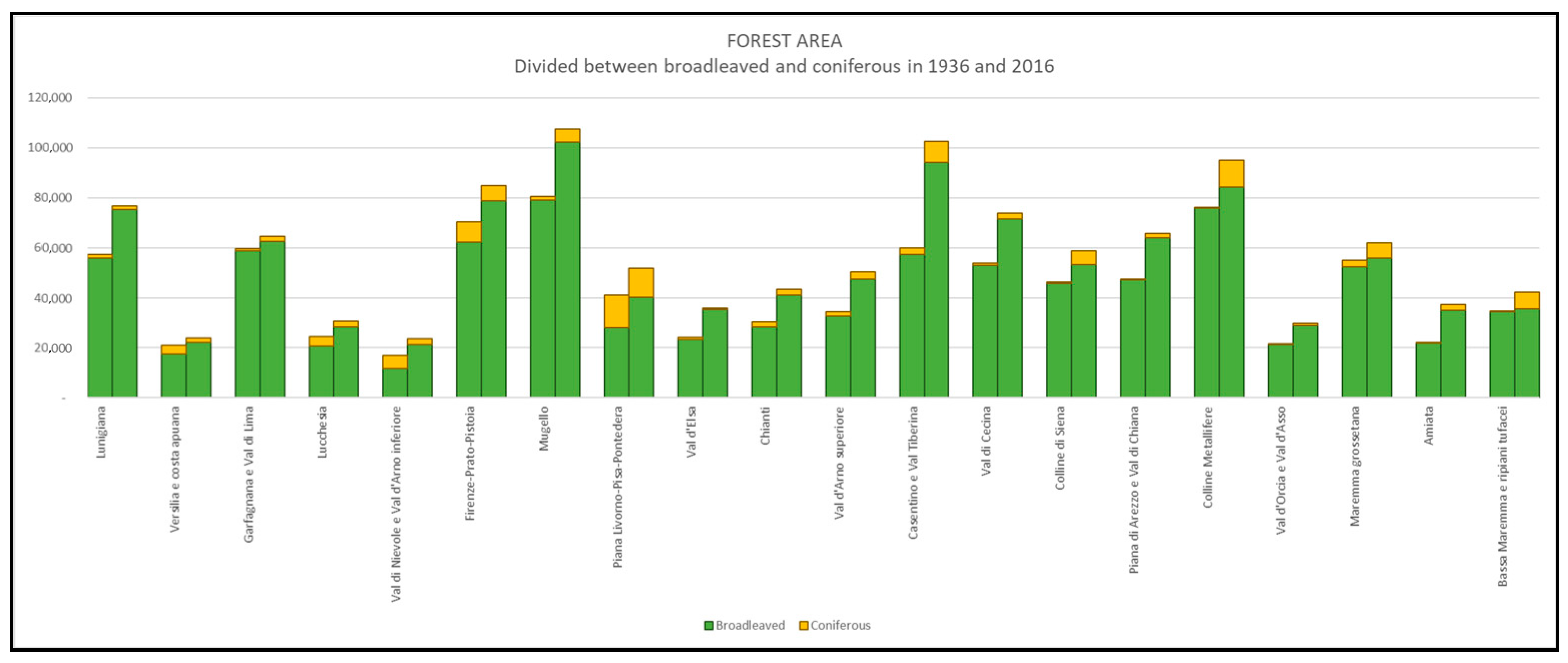
  • Broadleaved forests;
  • Coniferous forests;
  • Mixed forests of broadleaved and conifers.
The choice of these documents comes mostly by the availability of geo-referenced cartographic material with detailed information about forests. The 1936 forest map is used as the basis for all the elaborations, as it is the older available document with indications concerning the spatial distribution of forests in vector format. The 2016 land use was chosen because it represents the most recent official document with detailed spatial information, and therefore it can be compared to the one of 1936.
Relying on these two maps and database, different analyses have been conducted. First of all, a regional cartographic database has been created for 1936 and for 2016. Then the two have been compared highlighting the most significant changes. Despite that there are no recent georeferenced data about forest management types, some inventory information has been found.
The comparative analysis of the two historical periods made it possible to classify the forest surfaces in three macro-categories:
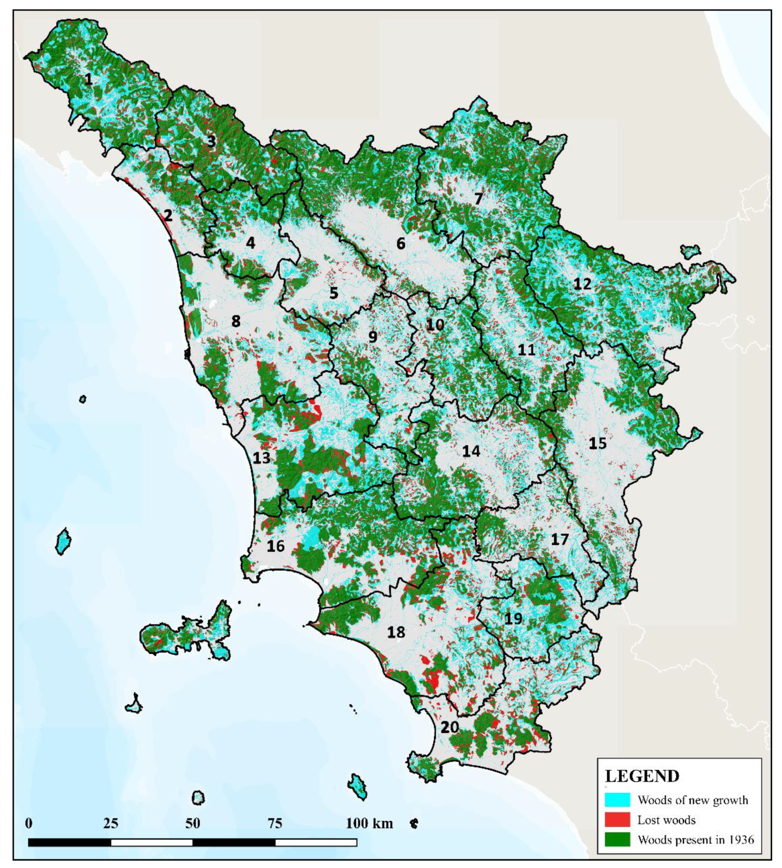
  • Woods present in 1936: all the forest surfaces of 2016 that were already covered by woods in 1936.
  • Woods of new growth: all the forest surfaces of 2016 that in 1936 were designed for other uses, such as agriculture and pastures, and therefore, this corresponds the surfaces in which the forests expanded in the period 1936–2016.
  • Lost woods: all the non-forest areas of 2016 that in 1936 were instead covered by forests, corresponding to the areas from which forests have been removed.
All the elaborations and analysis have been carried out through the use of QGIS software, with the help of GRASS plug-in.
The second step of the research focused on overlapping the data relating to the evolution of forest surfaces with the main regional planning tool, which in Tuscany Region is represented by the Landscape Plan (PIT) adopted in 2015. In Tuscany, the Landscape Plan is the main planning instrument of the region, which prevails over all the other regional planning levels as they must take into account the rules indicated by the plan. Landscape capital is defined as the “whole set of structures resulting from the long-term coevolution between nature and human society and an important value for the future generations” [51]. An active conservation of landscape resources, together with the protection of the cultural and natural heritage of the region represent the general view of the plan. The plan divides the regional territory in 20 Landscape Units (LU), homogenous areas with common characteristics and objectives regarding landscape and environment. The 20 landscape units, are therefore, an attempt to divide the territory according to both geographical and cultural qualities, identifying more or less homogeneous areas from a landscape, ecological, climatic and geomorphological point of view. They are presented within the plan with very detailed descriptions regarding different aspects. The boundaries of the landscape units follow the municipal boundaries, and their extension is very diverse: from the 500 km2 of the Lucca unit (LU4) to the over 1700 km2 of the Piana di Arezzo and Val di Chiana (LU15). The data obtained from the first part of the analysis have been studied through this subdivision into landscape units, in order to obtain homogeneous areas with similar cultural backgrounds and to assess the coherence of the description of the forest heritage of each landscape unit with the real evolution in the last century.

3. Results

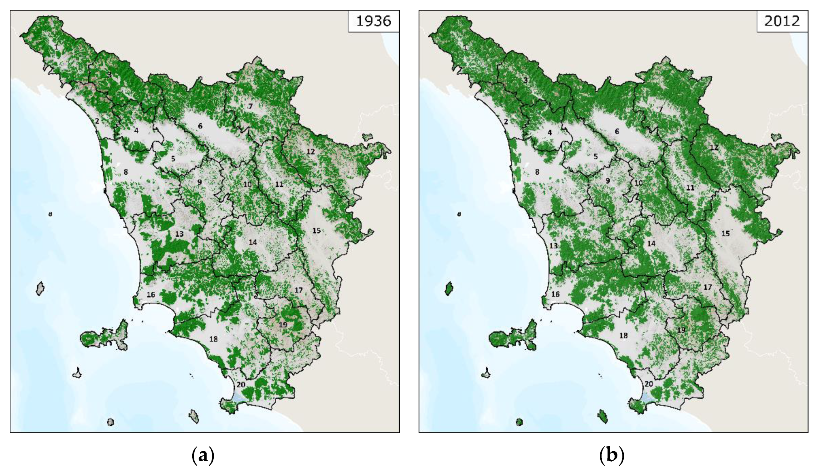
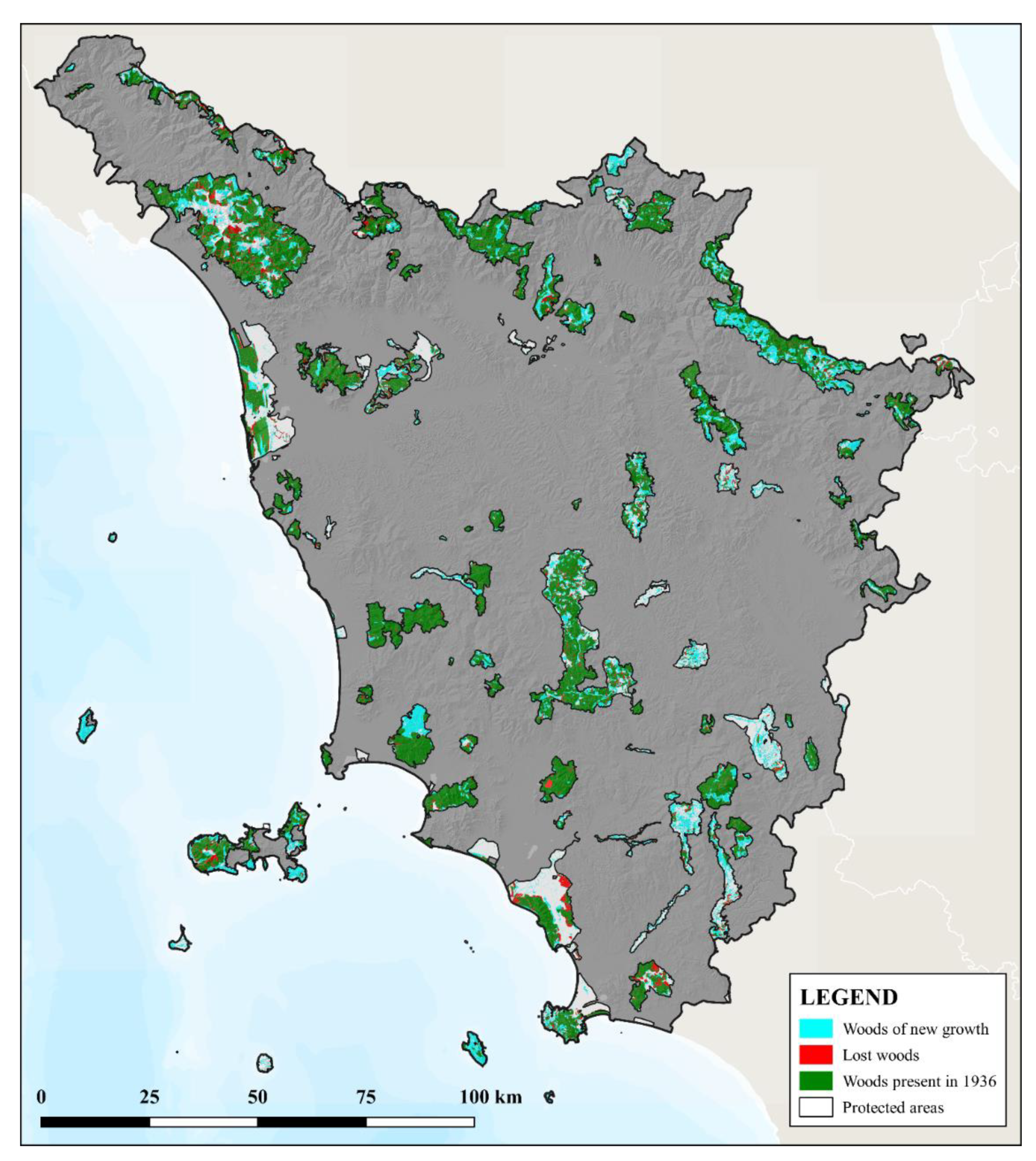
3.1. The Forests in Tuscany in 1936

Concerning the forest inventory of 1870 and the data of 1881, they show that about 70–80% of the regional forest surface was coppiced [47,48]. Conifers were used for timber production, while broadleaved were used also for grazing. Oak woods produced acorns to feed pigs, while chestnut forests are managed for producing nuts for human consumption. Concerning coppice woods, they produced firewood and charcoal, fagots and poles. Coppicing occurs also in form of pollarded trees, being the third type of coppice existing in the region.
The situation of the forests in 1936 (Figure 2) is typical of a rural society well integrated with the economy of the region. Traditional landscape is mainly made of cultivated fields, alternated with forests and pastures. The dominant species in the forests are oaks in the gentlest reliefs, chestnut and beech trees along the Apennine ridge, and stone pines, along the coast planted after the reclamation of the coastal swamps to protect the crops from the effect of the marine aerosol and floods and to produce pine nuts. In the plains the wood is almost absent, with a coverage of only 42,000 hectares (about 5% of the Tuscan woods of the time), as plains were dedicated almost exclusively to agricultural or urban activities. The population, although increased in the major urban centers, has not yet left the rural areas spread over the entire regional territory, which formed a very dense settlement up to the steepest hills.
This close relation between human culture and forests is testified by the study results about the forests management (Table 2), showing that more than 600,000 hectares out of a total of 827,000 hectares (equal to 72.6%) of broadleaved forests were managed as coppice. This data is particularly important, since it demonstrates that most of the woods in Tuscany have been utilized for centuries, interfering with species composition and structural characteristics, proving that the actual forests have a clear cultural origin.
However, the percentage of forests managed as coppices with respect to the totality of the broadleaved forests was very uneven according to the different landscape units. The highest values are all related to areas that occupy the central and coastal part of the region, especially where the morphology is not excessively harsh (in fact, in Versilia (LU2) and Amiata (LU19) these values are lower). Here, the traditional management of oaks forests was particularly important, since they do not provide only firewood and charcoal, but also acorns, leaves and branches, essential products for animal husbandry. The production of firewood is greater in a coppice than in a high forest, and the cut and transport of the wood according to the traditional techniques was easier, so coppice was largely applied. Moreover, in these areas the cultivation of cereals was more than enough for the local food needs, and the rare chestnut woods were also mostly coppiced to obtain different wood products, such as poles.
The lower values are instead mainly found in mountain areas, with very narrow valleys and with settlements that leaned on the wood not only for the collection of firewood, but also for the direct subsistence of the communities. Chestnut orchards in fact were essential for the local communities, and together with beech forests, they dominated the landscape.
Intermediate values are instead identified for the landscape units with hybrid characteristics between the two previous categories: these are often mountain areas but with large valley floors dedicated to agriculture. The landscape unit of Amiata Mountain (LU19) is peculiar. It can be considered purely mountain, despite it is not part of the Apennines range, and the characteristics of the local forests have been largely influenced by the human activities. In particular, most of the forests of the Amiata mountain were managed as simple coppices to provide fuelwood for the local mining activities that interested this area until the middle of the 20th century; the rest of the forests were mainly composed of chestnut groves, while the agricultural area was densely cultivated as a second job by the miners or used as pastures.

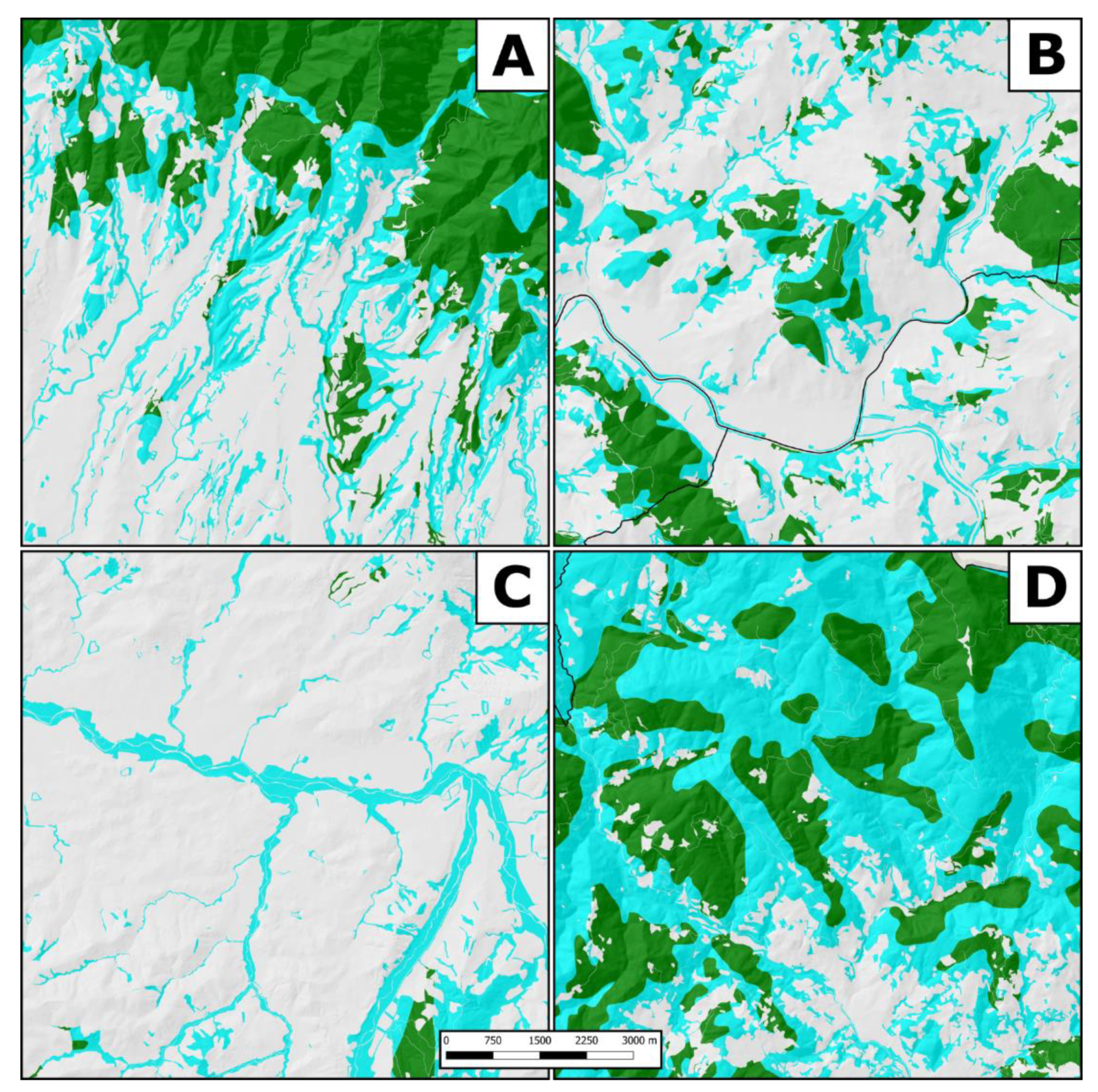
3.2. The Comparison with the Forests in 2016

The comparison with the 2016 situation (Figure 3, Table 3) clearly shows how much the wooded surface has increased since 1936. In only 80 years, the surface occupied by forests passes from 38% to 50%, with an average increase of more than 3500 hectares per year. The distribution of this increase according to the different altimetric zones is quite homogeneous, with a slightly higher growth in the hills. However, in 2016 the Tuscan forests are much more compact and with less jagged borders than in 1936, in particular on the slopes of the greater reliefs the characteristic open spaces that fragmented the woods into smaller plots have disappeared. Unfortunately, no recent geographic information is available at the regional level in relation to the type of forest management. Though, the Report on the State of the Forests in Tuscany of 2016 indicates that 63% of the forests of the region are coppices which, compared to 69% in 1936, is a rather high value—albeit decreasing. It is possible that the 2016 value also includes many old coppices and also recently abandoned ones within the definition of “coppice”. These are forests once governed as coppice, but that have now exceeded the usual number of ages between two cuts, but that still present aspects similar to those of the coppices, a situation in which many of these woods are found.
Overlaying the cartographies of 1936 and 2016 (Figure 4) it is possible to observe how the main phenomena is the increase of forests, that reaches about 448,700 ha of new forested surface on land previously used for other purposes, mainly agro-pastoral activities. On the other hand, about 163,000 ha of deforestation have been recorded, that are mainly located in the Mediterranean part of the region and probably correspond to the removal of degraded forests and maquis for new agricultural land or for infrastructures and buildings. Finally, there are 712,000 ha of forests in 1936 that are still forests.
Comparing the surface of new-formed forests with the total forest cover of 2016, it is possible to obtain the percentage of Tuscan forests deriving from the expansion on surfaces that in 1936 were used for agriculture or as pastures. The values fluctuate between 54% of landscape unit Amiata (LU19) to 20% of the Garfagnana and Val di Lima (LU3), with a regional average of 39%.
The landscape units that have higher percentages of new-formed forests are the ones that in 1936 were characterized by a highly developed agro-pastoral culture (Table 4). Val d’Elsa (LU9) and Chianti (LU10) are both units in which agriculture subtracted important spaces from the forest, even in areas where agricultural activities were more difficult, relegating it to small scattered plots. With the agricultural abandonment, even if these are landscape units where specialized agriculture (mainly vineyards) is common, the forest has colonized those surfaces that due to the slope are no longer convenient to cultivate. Casentino (LU12), on the other hand, was historically an area dedicated to pastoral activities: transhumance brought there, during the summer, all the herds that had spent the winter in the Maremma to take advantage of the Apennine pastures; consequently, the forest alternated with wide open spaces dedicated to these activities, forming a jagged mosaic of ridge pastures, meadows and forests. Mount Amiata, which historically is dedicated to mining activities, has undergone an almost complete cessation of forest utilizations, since there is no more need of firewood and charcoal for foundries. This situation combined with the local depopulation, led to the abandonment of forest management and of numerous pastures and crops, allowing the wood to occupy them.
Garfagnana (LU3) (20%), Florence-Prato-Pistoia plain (LU6) (28%) and Lucca area (LU4) (32%) are the landscape units that have registered the lowest values of new forests. In the first case, the surface of forests in 1936 was already extremely dominant occupying most of the slopes, leaving however large pastures; consequently, a low increase in percentage in reality corresponds to a high increase in hectares, and in fact the forest in 2016 occupies a large part of the pastures no longer used, both on the mountain ridges, where the beech-woods expanded, and on the valley floors.
The situation in the Florence-Prato-Pistoia basin (LU6) is similar to the Lucca area (LU4: a large part of the first one was and still is occupied by the alluvial plain of the Arno and its tributaries, where the forest cover has always been almost absent). The territories where the woods are concentrated are the reliefs of the Pistoia mountains, but even in 1936 they were already almost completely covered by forests, and consequently the expansion was rather reduced, both in percentage and in hectares, mostly concerning the numerous and scattered abandoned pastures. The Lucca area (LU4) shows a similar situation: it is mainly occupied by a wide alluvial valley where the forest was a marginal land use, but the hills in the northern part, once occupied by an alternation of forests, pastures and cultivated fields, currently present a landscape almost completely occupied by an uninterrupted wood.
Deforested areas, nearly 165,000 ha, are generally scattered all over Tuscany in the borders between the current forests and other lands uses. These are very fragmented surfaces, often of very few hectares, mainly derived from the reorganization of borders. In the lowlands, particularly in the Grosseto area (LU18), this loss can sometimes be identified with the effects of land reclamation.
From the graph with the subdivision between broadleaved and coniferous forests (Figure 5), it is possible to observe that the percentage of broadleaved forests slightly decreased in the period 1936–2016, from 94% to 93%. Twelve landscape units have registered a loss between −1% (Garfagnana (LU3), Val d’Arno superiore (LU11), Val di Cecina (LU13)) and −15% (Bassa Maremma e ripiani tufacei (LU20)). Compared to 1936, most of the landscape units report a rather high hectare increase in conifer cover, with the exception of Val di Nievole (LU5), Livorno-Pisa-Pontedera plain (LU8), Versilia (LU2), Lucchesia (LU4), Firenze-Prato-Pistoia plain (LU6) and Val d’Elsa (LU9).
The increase of forest surfaces does not follow random models. At regional scale, the landscape changes due to reforestation occurred mostly on mountains and hills, while in the plains of the Arno valley urbanization prevailed reducing the forests with an increasing speed since 1954. In the rural areas of our study, we identified four main types of forest expansion.
The first model (Figure 6a) identifies the descent of the forest from the mountain slopes towards the valley floors. In 1936 most of the mountain sides were cultivated, but with the passing years, those areas become fewer and fewer suitable for a competitive agriculture, leading to a progressive abandonment and to the consequent colonization by the forests.
The second model (Figure 6b) is instead more common on low-hilly terrains, and corresponds to the spread of an original forest core—usually in the past regularly managed by the local farmers—all over the surrounding areas, creating a new, wider and compact patch of forest. Again, this process happened due to the abandonment of the less suitable farming areas, where the slopes are not really steep, but not suitable for intensive systems.
The third model (Figure 6c) is mainly found inside the alluvial plains, and it identifies a process of recolonization of the riversides by the riparian vegetation. This type of forestation can be more or less intense, from just a few meters alongside to dozens of meters in both sides. This increase is also the consequence of planning and conservation policies aimed at protecting the banks of the rivers.
The last model (Figure 6d) is widespread over all the mountains of Tuscany, mainly in the Apennine range. It corresponds to the abandonment of the pastures located at higher altitudes, once used during the summer. Due to the cessation of transhumance and of the summer utilization of high pastures, forests slowly colonized these terrains, creating huge continual forest patches that cover without interruption the higher part of the mountains, sometimes up to the ridge.
Finally, an overlapping of the results with the presence of protected areas has been carried out (Figure 7). The system of protected areas includes national parks, regional parks, natural reserves, provincial parks, sites of regional interest, special conservation areas and Natura 2000 sites (sites of community importance, special protection areas). 17.54% of the regional surface is included in protected areas, and 70% (283,477 ha) of protected areas are occupied by forests. Further, 30% (84,484 ha) of actual forests included in protected areas are the result of secondary successions, as this surface was not classified as forests in 1936. On the other hand, 30% of the protected surface is not wooded (equal to 119,704 ha), and more than one fifth of these surfaces (25,690 ha) derives from the deforestation. In addition, two thirds of 1936 forests, actually included in protected areas, were managed as coppice.

4. Discussion

The history of the Tuscan forests is given by the integration of a complex of natural, social, economic and political factors, which have not yet been addressed with sufficient clarity. Although some general trends have already been identified, there are a lack of studies that analyzed the multiple realities of the regional territory and the processes that at a local scale involved man and forest [52]. Due to some trends in nature conservation and environmental protection [53], there is the growing tendency to interpret, present, protect and manage the forests of Tuscany as if they had a natural origin, or as if they should be turned into natural forests. This happens through landscape planning and various protection tools, more and more often limiting traditional forest management forms, favoring an increasing level of naturalness [54]. The Landscape Plan, which prevails over all the other regional and local planning instruments, includes detailed descriptions of the different forest types of Tuscany, but it lacks in highlighting the cultural values that have shaped them, as it is more focused on the ecological role. In addition, the plan considers some historical management forms, as coppicing as a degradation, fostering a conversion of coppice woods to high stands. Recently, there has been also an intervention of public authorities in charge of landscape conservation denying the authorization to continue coppice management claiming that this technique cannot be considered a traditional form of forest management expressing the cultural values of the regional landscape. For these reasons, it is important to determine the transformations that have affected the forests of Tuscany in the last century, in terms of surface, specific composition and management methods.
Results showed that most of the Tuscan forests were largely used in 1936 with different types of management forms. A total 76% of broadleaved forests were managed as coppice, confirming that this kind of management dating back to the Roman Empire, represent the oldest traditional form of systematic forest utilization [55]. Coppices do not just represent a traditional sustainable form of forest management, but should be promoted at European level to put back into production abandoned forests. This would have positive impacts on the valuable and unique coppice flora and fauna, on climate change mitigation, on rural economy and on forest fires prevention [56].
In 1936, although the migration to the cities already slowly begun, the rural population occupied even the most rugged areas and the economy was still based on agricultural and forestry productions, with a landscape mainly made of forests often combined with large areas dedicated to agricultural or pastoral activities. Livestock and agriculture were closely dependent on forests, both in mountain and hilly areas, creating complex landscape mosaics with high biocultural diversity. With the end of the practice of pastoral transhumance, the role of these open spaces has disappeared, and the forest had the opportunity to occupy them, leaving uncovered surfaces only in the valley floors. Tuscan woods were once fundamental for the rural economy and were for the most part managed to obtain a wide range of products useful for agricultural activities. These included wood products, such as timber, firewood, wood for charcoal production, poles for fences, and non-wood forest products such as chestnuts a state of abandonment, mainly due to diseases, low economic value of the chestnut, high costs of collecting chestnut (it must be made mainly by hand), depopulation of the for flour in places were cereals cultivation was difficult, oak acorns to feed grazing pigs, leaves to use in stables during the winter. The role of the chestnut orchards was fundamental for the mountain communities of all the central Apennines. Chestnuts have been the basis of the alimentation of the Apennines population for centuries. Currently there are about 32,000 hectares of chestnut orchards in Tuscany, but more than the half of these are in mountains [57]. The loss of these woods is particularly significant, as they are a traditional features of the mountain landscape, with high biodiversity and cultural value, and often with monumental trees. Beech forests, almost entirely governed as coppice, were largely used in the mountains for charcoal and firewood.
The current situation, shows a completely different condition: forests have significantly increased their surface, occupying more than half of the Tuscan region, and it is less and less correlated with areas used for pasture and for agriculture. Our results demonstrated the increase of forest surface, and are coherent with similar studies. For example, the regional report on the state of landscape policies [54] report an increase of 160,678 ha of forests in the period 1954–2016, which means about more than 2500 ha of new forests per year. Furthermore, forests have lost their economic importance, with a reduction in the surface regularly managed and used. This trend is common to different European countries, mainly due to afforestation, nature conservation and farmland abandonment [58,59,60] and unmanaged forests can also increase erosion and hydrogeological risk [61,62]. Finally, one of the main causes of the reduction in the percentage of broadleaved forests certainly derives from the direct afforestation carried out planting pines on degraded surfaces, already begun in the late nineteenth century and increased in the mid-twentieth century [63], which has unbalanced the ratio towards this type of forest.
Results demonstrates that the current characteristics of most of the forests of Tuscany are the result of traditional practices carried out for centuries, affecting extension, density, structure and species composition. They are basically cultural forests, shaped by humans, including those in protected areas. The comparison between the digitized map of 1936 and the land uses system of the year 2016, shows that almost one third of the present forest area is the result of secondary successional forests, a consequence of the abandonment of cultivations and pastures or of coppice management occurred in the last decades. This demonstrates that, as for Italy and several European countries, there are no deforestation processes occurring, but an extended reforestation due to the abandonment of agricultural land, causing a degradation of landscape quality, the growing import of food contributing to the increase of the ecological footprint, and altering the balance and distribution of the different land uses. The deforestation occurred in the last hundred years in Italy is mainly located around urban areas developed in the plains, while reforestation has affected mountain and hills following different models explained in this paper.
The functions developed by cultural forests meets the objectives of the climate strategy, as they incorporate CO2 that can be removed by regular forest management, as occurring with coppicing. The biodiversity goals are also met, since the presence of various management forms contributes to create and preserve different habitats and microhabitats, differently from a homogeneous forest cover. Further, animal species are present and widely distributed in the territory, although, as stated by the UNESCO—CBD Florence declaration of 2014, the type of biodiversity characterizing these territories is the “biocultural diversity” [12]. There are no major disadvantages in maintaining cultural forests. Concerning the criteria of sustainable forest management in Europe, the conservation of cultural forests perfectly meets the content of the third pillar of SFM defined in 2003 by the MCPFE [2].

5. Conclusions

The lack of attention to preserve cultural forests is particularly problematic for Tuscany since cultural landscape represents the identity of the region and its conservation is in line with the European Landscape Convention and the Italian Code for Cultural Heritage. However, during the years, the interpretation and the applications of conservation tools has gradually limited traditional forest practices favoring the development of seminatural forests. With reference to the Landscape Plan of Tuscany, while nature conservation and hydrogeological protection associated to forests are carefully considered, with the identification of critical issues and possible countermeasures, it is instead neglected the cultural and historical values of forests. Cultural values are only taken into consideration in relation to agricultural areas, and the forest is mentioned—under this aspect—only when it represents a primary component in agro-pastoral activities, while traditional forests management, such as simple coppice, are often considered a form of degradation. As a result of this set of planning and conservation tools, landscape features are no longer determined by the long-term interaction between humans and forests, but by law.
An effective planning and management of forest resources cannot be detached by cultural values and the associated traditional knowledge, which are part of the concept and the goals of sustainable forest management [1]. Neglecting these values will give a limited contribution to the functions assigned to the forest depending to their extension or degree of naturalness, but will significantly contribute to the degradation of the cultural landscape that depends on qualitative and not quantitative features.

Author Contributions

Conceptualization, F.P., A.S. and M.A.; methodology, F.P., M.V., F.C. and A.S.; software, F.P.; writing—original draft preparation, M.V., F.C. and A.S.; supervision, A.S. and M.A. All authors have read and agreed to the published version of the manuscript.

Funding

This research received no external funding.

Data Availability Statement

The data presented in this study are available on request from the corresponding author.

Conflicts of Interest

The authors declare no conflict of interest.

References

  1. Parrotta, J.A.; Agnoletti, M. Traditional forest knowledge: Challenges and opportunities. For. Ecol. Manag. 2007, 249, 1–4. [Google Scholar] [CrossRef]
  2. MCPFE. Vienna Resolution 3. In Proceedings of the Expert Level Meeting of the Ministerial Conference for the Protection of Forests in Europe, Warsaw, Poland, 14–15 October 2004. [Google Scholar]
  3. Agnoletti, M.; Anderson, A.; Johann, E.; Kulvik, M.; Kushlin, A.; Mayer, P.; Montiel Molina, C.; Parrotta, J.; Rotherham, I.D.; Saratsi, E. The Introduction of Historical and Cultural values in the Sustainable Management of European Forests. Glob. Environ. 2008, 2, 171–199. [Google Scholar] [CrossRef]
  4. United Nations Forum on Forests (UNFF). Report of the Secretary-General: Traditional Forest-Related Knowledge (E/CN.18/2004/7); United Nations Forum on Forests (UNFF): New York, NY, USA, 2004. [Google Scholar]
  5. Camacho, L.D.; Gevaña, D.T.; Carandang, A.P.; Camacho, S.C. Indigenous knowledge and practices for the sustainable management of Ifugao forests in Cordillera, Philippines. Int. J. Biodivers. Sci. Ecosyst. Serv. Manag. 2016, 12, 5–13. [Google Scholar] [CrossRef]
  6. Pezzi, G.; Gambini, S.; Buldrini, F.; Ferretti, F.; Muzzi, E.; Maresi, G.; Nascimbene, J. Contrasting patterns of tree features, lichen, and plant diversity in managed and abandoned old-growth chestnut orchards of the northern Apennines (Italy). For. Ecol. Manag. 2020, 470, 118207. [Google Scholar] [CrossRef]
  7. Roman, F.; Valerino, L. Changements du paysage et biodiversité dans les châtaigneraies cévenoles (sud de la France). Ecol. Mediterr. 1997, 23, 121–129. [Google Scholar] [CrossRef]
  8. Agnoletti, M.; Santoro, A. Cultural values and sustainable forest management: The case of Europe. J. For. Res. 2015, 20, 438–444. [Google Scholar] [CrossRef]
  9. Pandey, D.N. Ethnoforestry: Local Knowledge for Sustainable Forestry and Livelihood Security; Himanshu Publications: Udaipur, India, 1998. [Google Scholar]
  10. Maffi, L. Biocultural Diversity and Sustainability. In The SAGE handbook of Environmental and Society; SAGE publications: London, UK, 2007. [Google Scholar]
  11. UNESCO; sCBD. UNESCO–CBD Joint Program between Biological and Cultural Diversity; UNESCO: Paris, France, 2010. [Google Scholar]
  12. UNESCO; sCBD. Florence Declaration on the Links between Biological and Cultural Diversity; UNESCO: Florence, Italy, 2014; Available online: https://www.landscapeunifi.it/land/wp-content/uploads/2013/10/UNESCO-CBD_JP_Florence_Declaration.pdf (accessed on 30 March 2021).
  13. Agnoletti, M.; Rotherham, I.D. Landscape and Biocultural Diversity. Biodivers. Conserv. 2015, 24, 3155–3165. [Google Scholar] [CrossRef] [Green Version]
  14. Koohafkan, P.; Altieri, M.A. Globally Important agricultural heritage systems. In A Legacy for the Future; Food and Agriculture Organization of the United Nations: Rome, Italy, 2011. [Google Scholar]
  15. Santoro, A.; Venturi, M.; Bertani, R.; Agnoletti, M. A review of the role of forests and agroforestry systems in the FAO Globally Important Agricultural Heritage Systems (GIAHS) programme. Forests 2020, 11, 860. [Google Scholar] [CrossRef]
  16. Ciesielski, M.; Stereńczak, K. What do we expect from forests? The European view of public demands. J. Environ. Manag. 2018, 209, 139–151. [Google Scholar] [CrossRef]
  17. Nieto-Romero, M.; Oteros-Rozas, E.; González, J.A.; Martín-López, B. Exploring the knowledge landscape of ecosystem services assessments in Mediterranean agroecosystems: Insights for future research. Environ. Sci. Policy 2014, 37, 121–133. [Google Scholar] [CrossRef]
  18. Vizzarri, M.; Tognetti, R.; Marchetti, M. Forest ecosystem services: Issues and challenges for biodiversity, conservation, and management in Italy. Forests 2015, 6, 1810–1838. [Google Scholar] [CrossRef] [Green Version]
  19. Solomou, A.D.; Karetsos, G.; Skoufogianni, E.; Martinos, K.; Sfougaris, A.; Tsagari, K. Assessment of Greek forests protection and management. In Sustainable Development in Mountain Regions; Springer International Publishing: Cham, Switzerland, 2016; pp. 141–166. [Google Scholar] [CrossRef]
  20. Malek, Z.; Verburg, P. Mediterranean land systems: Representing diversity and intensity of complex land systems in a dynamic regions. Landsc Urban. Plan. 2017, 165, 102–116. [Google Scholar] [CrossRef] [Green Version]
  21. Calder, I.R. Forests and hydrological services: Reconciling public and science perceptions. Land Use Water Resour. Res. 2002, 2. [Google Scholar] [CrossRef]
  22. Kuuluvainen, T. Forest management and biodiversity conservation based on natural ecosystem dynamics in northern Europe: The complexity challenge. AMBIO A J. Hum. Environ. 2009, 38, 309–315. [Google Scholar] [CrossRef] [PubMed]
  23. Gołos, P. Social importance of public forest functions-desirable for recreation model of tree stand and forest. For. Res. Pap. 2010, 71, 149–164. [Google Scholar] [CrossRef] [Green Version]
  24. Eriksson, L.; Nordlund, A.M.; Olsson, O.; Westin, K. Recreation in different forest settings: A scene preference study. Forests 2012, 3, 923–943. [Google Scholar] [CrossRef]
  25. Gundersen, V.S.; Frivold, L.H. Public preferences for forest structures: A review of quantitative surveys from Finland, Norway and Sweden. Urban. For. Urban. Green. 2008, 7, 241–258. [Google Scholar] [CrossRef]
  26. Mittermeier, R.A.; Robles-Gil, P.; Hoffmann, M.; Pilgrim, J.; Brooks, T.; Mittermeier, C.G.; Lamoreux, J.; Da Fonseca, G.A.B. Hotspots Revisited: Earth’s Biologically Richest and Most Endangered Terrestrial Ecoregions; CEMEX: Mexico City, Mexico, 2004. [Google Scholar]
  27. Martín-Bravo, S.; Valcárcel, V.; Vargas, P.; Luceño, M. Geographical speciation related to Pleistocene range shifts in the western Mediterranean mountains (Reseda sect. Glaucoreseda, Resedaceae). Taxon 2010, 59, 466–482. [Google Scholar] [CrossRef]
  28. Karetsos, G.; Solomou, A.D.; Trigas, P.; Tsagari, K. The vascular flora of Mt. Oiti National Park and the surrounding area in Greece. J. For. Sci. 2018, 64, 435–454. [Google Scholar] [CrossRef] [Green Version]
  29. Plexida, S.; Solomou, A.; Poirazidis, K.; Sfougaris, A. Factors affecting biodiversity in agrosylvopastoral ecosystems with in the Mediterranean Basin: A systematic review. J. Arid Environ. 2018, 151, 125–133. [Google Scholar] [CrossRef]
  30. Médail, F.; Monnet, A.C.; Pavon, D.; Nikolic, T.; Dimopoulos, P.; Bacchetta, G.; Arroyo, J.; Barina, Z.; Albassatneh, M.C.; Domina, G.; et al. What is a tree in the Mediterranean Basin hotspot? A critical analysis. For. Ecosyst. 2019, 6, 1–19. [Google Scholar] [CrossRef] [Green Version]
  31. Proutsos, N.; Solomou, A.; Karetsos, G.; Tsagari, K.; Mantakas, G.; Kaoukis, K.; Bourletsikas, A.; Lyrintzis, G. The Ecological Status of Juniperus foetidissima Forest Stands in the Mt. Oiti-Natura 2000 Site in Greece. Sustainability 2021, 13, 3544. [Google Scholar] [CrossRef]
  32. Spampinato, G.; Crisarà, R.; Cannavò, S.; Musarella, C.M. Phytotoponims of southern Calabria: A tool for the analysis of the landscape and its transformations. Atti Soc. Toscana Sci. Nat. Mem. Ser. B 2017, 124, 61–72. [Google Scholar] [CrossRef]
  33. Pasta, S.; Sala, G.; La Mantia, T.; Bondì, C.; Tinner, W. The past distribution of Abies nebrodensis (Lojac.) Mattei: Results of a multidisciplinary study. Veget. Hist. Archaeobot. 2020, 29, 357–371. [Google Scholar] [CrossRef]
  34. Hong, S.-K.; Nakagoshi, N.; Fu, B.J.; Morimoto, Y. (Eds.) Landscape Ecological Applications in Man-Influenced Areas: Linking Man and Nature Systems. In Landscape Ecological Applications in Man-Influenced Areas; Springer: Dordrecht, The Netherlands, 2008; pp. 1–6. [Google Scholar]
  35. Fischer, A.P. Forest landscapes as social-ecological systems and implications for management. Landsc. Urban. Plan. 2018, 177, 138–147. [Google Scholar] [CrossRef]
  36. Östlund, L.; Zackrisson, O.; Hörnberg, G. Trees on the border between nature and culture: Culturally modified trees in boreal Sweden. Environ. Hist. 2002, 7, 48–68. [Google Scholar] [CrossRef]
  37. Johann, E.; Agnoletti, M.; Axelsson, A.L.; Bürgi, M.; Östlund, L.; Rochel, X.; Winiwater, V. History of secondary Norway spruce forests in Europe. In European Forest Institute Research Report; Spiecker, H., Hansen, J., Klimo, E., Skovsgaard, J.P., Sterba, H., von Teufel, K., Eds.; Norway Spruce Conversion—Options and Consequences; Brill: Leiden, Netherlands, 2004; pp. 25–62. [Google Scholar]
  38. IRPET. Rapporto Sullo Stato Delle Foreste in Toscana 2019; IRPET—Istituto Regionale Programmazione Economica Toscana & Compagnia Delle Foreste: Firenze, Italy, 2020. [Google Scholar]
  39. Regione Toscana. Quadro Strategico Regionale per uno Sviluppo Sostenibile ed Equo. Ciclo di Programmazione Comunitaria 2021–2027; Regione Toscana: Firenze, Italy, 2019. [Google Scholar]
  40. Agnoletti, M.; Santoro, A. Rural landscape planning and forest management in Tuscany (Italy). Forests 2018, 9, 473. [Google Scholar] [CrossRef] [Green Version]
  41. Sereni, E. Storia del Paesaggio Agrario Italiano; Laterza: Bari, Italy, 1961. [Google Scholar]
  42. Ruiz-Flan, P.; Garci, J.M.; Ortigosa, L. Geomorphological evolution of abandoned fields. A case study in the Central Pyrenees. Catena 1992, 19, 301–308. [Google Scholar] [CrossRef]
  43. Stanchi, S.; Freppaz, M.; Agnelli, A.; Reinsch, T.; Zanini, E. Properties, best management practices and conservation of terraced soils in Southern Europe (from Mediterranean areas to the Alps): A review. Quat. Int. 2012, 265, 90–100. [Google Scholar] [CrossRef] [Green Version]
  44. Stoate, C.; Báldi, A.; Beja, P.; Boatman, N.D.; Herzon, I.; Van Doorn, A.; de Snoo, G.R.; Rakosy, L.; Ramwell, C. Ecological impacts of early 21st century agricultural change in Europe: A review. J. Environ. Manag. 2009, 91, 22–46. [Google Scholar] [CrossRef]
  45. Johann, E. Traditional forest management under the influence of science and industry: The story of the alpine cultural landscapes. Ecol. Manag. 2007, 249, 54–62. [Google Scholar] [CrossRef]
  46. D.Lgs. n. 42/2002—Code of the Cultural and Landscape Heritage, Pursuant to Article 10 of Law no. 137 of 6 July 2002; GU Serie Generale n.45-Suppl. Ordinario n. 28: Roma, Italy. 2002. Available online: https://www.unodc.org/cld/en/legislation/ita/legislative_decree_no._42_of_22_january_2004-_code_of_the_cultural_and_landscape_heritage/title_i/articles_1_2_3/code_of_the_cultural_and_landscape_heritage.html? (accessed on 29 March 2021).
  47. MAIC. Statistica Forestale del Regno d’Italia; MAIC: Firenze, Italy, 1870. [Google Scholar]
  48. Mazzini, C.M. La Toscana Agricola; Tipografia del Senato: Rome, Italy, 1881. [Google Scholar]
  49. Gabbrielli, A. Le Trasformazioni del Paesaggio Forestale in Toscana: Un Tentativo di Sintesi Storica; Accademia Italiana di Scienze Forestali: Firenze, Italy, 1997; Volume Quarantaseiesimo. [Google Scholar]
  50. Puddu, G. Le trasformazioni del paesaggio viste attraverso la cartografia storica: Il caso della regione Sardegna; Università degli studi della Tuscia: Viterbo, Italy, 2010. [Google Scholar]
  51. Giunta Regionale Toscana. Piano di Indirizzo Territoriale con valenza di Piano Paesaggistico; Giunta Regionale Toscana: Toscana, Italy, 2015. [Google Scholar]
  52. AA.VV. La Toscana dei boschi; Edizioni Vallombrosa; Regione Toscana Giunta Regionale: Florence, Italy, 2020. [Google Scholar]
  53. Rotherham, I.D. The call of the wild: Perceptions, history people & ecology in the emerging paradigms of wilding. ECOS 2014, 35, 35–43. [Google Scholar]
  54. Regione Toscana. Rapporto sullo stato delle politiche del paesaggio; Regione Toscana: Florence, Italy, 2020. [Google Scholar]
  55. EuroCoppice Working Group 5. Socio-Economic Factors Influencing Coppice Management in Europe; COST Action FP1301 Reports; Albert Ludwig University: Freiburg, Germany, 2017. [Google Scholar]
  56. Becker, G.; Unrau, A. Coppice forests in Europe. A Traditional Landuse with New Perspectives. In Coppice Forests in Europe; Unrau, A., Becker, G., Spinelli, R., Lazdina, D., Magagnotti, N., Nicolescu, V.N., Buckley, P., Bartlett, D., Kofman, P.D., Eds.; Albert Ludwig University: Freiburg, Germany, 2018; pp. 18–21. [Google Scholar]
  57. Bianchi, L.; Maltoni, A.; Mariotti, B.; Paci, M. La Selvicoltura dei Castagneti da frutto Abbandonati della Toscana; Arsia Regione Toscana: Sesto Fiorentino, Italy, 2009. [Google Scholar]
  58. Tieskens, K.F.; Schulp, C.J.; Levers, C.; Lieskovský, J.; Kuemmerle, T.; Plieninger, T.; Verburg, P.H. Characterizing European cultural landscapes: Accounting for structure, management intensity and value of agricultural and forest landscapes. Land Use Policy 2017, 62, 29–39. [Google Scholar] [CrossRef] [Green Version]
  59. Pereira, H.M.; Leadley, P.W.; Proença, V.; Alkemade, R.; Scharlemann, J.P.; Fernandez-Manjarrés, J.F.; Araújo, M.B.; Balvanera, P.; Biggs, R.; Cheung, W.W.L.; et al. Scenarios for global biodiversity in the 21st century. Science 2010, 330, 1496–1501. [Google Scholar] [CrossRef] [PubMed] [Green Version]
  60. Jepsen, M.R.; Kuemmerle, T.; Müller, D.; Erb, K.; Verburg, P.H.; Haberl, H.; Vesterager, J.P.; Andrič, M.; Antrop, M.; Austrheim, G.; et al. Transitions in European land-management regimes between 1800 and 2010. Land Use Policy 2015, 49, 53–64. [Google Scholar] [CrossRef]
  61. Agnoletti, M. The degradation of traditional landscape in a mountain area of Tuscany during the 19th and 20th centuries: Implications for biodiversity and sustainable management. For. Ecol. Manag. 2007, 249, 5–17. [Google Scholar] [CrossRef]
  62. Brandolini, P.; Cevasco, A.; Capolongo, D.; Pepe, G.; Lovergine, F.; Del Monte, M. Response of terraced slopes to a very intense rainfall event and relationships with land abandonment: A case study from Cinque Terre (Italy). Land Degrad. Dev. 2018, 29, 630–642. [Google Scholar] [CrossRef]
  63. Ciabatti, G.; Gabellini, A.; Ottaviani, C.; Perugi, A. I rimboschimenti in Toscana e la loro Gestione; Arsia Regione Toscana: Sesto Fiorentino, Italy, 2009. [Google Scholar]
Figure 1. The 1338 frescos by Ambrogio Lorenzetti called “the wise management” (a) and the “bad management” (b).
Forests 12 00531 g001
Figure 2. The distribution of the main forest types in Tuscany in 1936.
Forests 12 00531 g002
Figure 3. The comparison between the surface covered by forests in 1936 (a) and in 2016 (b). It is clear that forests have increased the surface by expanding their borders and by filling the gaps.
Forests 12 00531 g003
Figure 4. Overlapping the forest maps of 1936 and 2016 it is possible to identify the new forests (light blue), the deforested areas (red) and the areas that currently covered by forests and that were already forests in 1936 (green).
Forests 12 00531 g004
Figure 5. Conifer and broadleaved forests in 1936 and 2016 for each landscape unit. Conifer forests have almost everywhere increased as a consequence of direct afforestation carried out during the last century.
Forests 12 00531 g005
Figure 6. Models of reforestation, with the areas that were forests in 1936 in green and the expansion of forested areas in cyan. (A) descent of the forest from the mountain sides towards the valley floor (Landscape Unit 7); (B) expansion of the forest starting from small cores (Landscape Unit 7); (C) forestation along the rivers (Landscape Unit 17); (D) closure of the high mountain pastures (Landscape Unit 12).
Forests 12 00531 g006
Figure 7. Map of areas that were already forests in 1936 (in green) and the expansion of forested areas (in cyan) overlapped with the protected areas system of Tuscany. In red, the surfaces that where forest in 1936 and that today are not forest anymore.
Forests 12 00531 g007
Table 1. Reclassification of the 1936 forest types for the comparison with 2016 land use map.
1936 Forest MapReclassification
Beech forestsBroadleaved forests
Chestnut forestsBroadleaved forests
ConifersConiferous forests
Degraded forestsDegraded forests
Forests with other species or mixed forestsBroadleaved forests
Oak forestsBroadleaved forests
Table 2. The table shows the importance of coppice management technique for the different landscape units, testifying the close interaction between men and forests.
Landscape UnitHigh ForestCoppiceTotal Broadleaved
(ha)(%)(ha)(%)(ha)
1Lunigiana29,899 53%26,144 47%56,042
2Versilia e costa apuana12,442 71%5007 29%17,449
3Garfagnana e Val di Lima40,723 69%18,112 31%58,835
4Lucchesia12,360 60%828940%20,649
5Val di Nievole e Val d’Arno inferiore4136 36%7417 64%11,553
6Firenze-Prato-Pistoia22,378 36%40,003 64%62,381
7Mugello17,687 22%61,322 78%79,009
8Piana Livorno-Pisa-Pontedera388 1%27,684 99%28,072
9Val d’Elsa1972 9%21,107 91%23,079
10Chianti2599 9%25,756 91%28,355
11Val d’Arno superiore10,066 31%22,773 69%32,839
12Casentino e Val Tiberina18,978 33%38,438 67%57,416
13Val di Cecina6649 13%46,439 87%53,088
14Colline di Siena4156 9%41,633 91%45,789
15Piana di Arezzo e Val di Chiana10,751 23%36,620 77%47,371
16Colline Metallifere8397 11%67,549 89%75,946
17Val d’Orcia e Val d’Asso892 4%20,221 96%21,113
18Maremma grossetana2582 5%49,993 95%52,575
19Amiata9016 42%12,601 58%21,617
20Bassa Maremma e ripiani tufacei5659 16%28,802 84%34,461
TUSCANY221,73027%605,91173%827,640
Table 3. Total coverage of forests, in hectares and percentage, in 1936 and 2016 for each landscape units.
Forest Surface 1936Forest Surface 2016
Landscape UnitTotatal Surface (ha)(ha)(%)(ha)(%)
1Lunigiana97,451 57,284 59%76,687 79%
2Versilia e costa apuana53,938 20,920 39%23,797 44%
3Garfagnana e Val di Lima83,400 59,742 72%64,753 78%
4Lucchesia58,366 24,228 42%30,651 53%
5Val di Nievole e Val d’Arno inferiore78,305 16,838 22%23,415 30%
6Firenze-Prato-Pistoia160,843 70,266 44%84,949 53%
7Mugello150,731 80,493 53%107,469 71%
8Piana Livorno-Pisa-Pontedera157,841 41,034 26%51,849 33%
9Val d’Elsa90,561 23,991 26%36,014 40%
10Chianti77,024 30,395 39%43,337 56%
11Val d’Arno superiore92,368 34,411 37%50,531 55%
12Casentino e Val Tiberina150,032 60,081 40%102,603 68%
13Val di Cecina136,987 53,898 39%73,980 54%
14Colline di Siena131,426 46,374 35%58,889 45%
15Piana di Arezzo e Val di Chiana176,625 47,558 27%65,740 37%
16Colline Metallifere169,846 76,264 45%95,001 56%
17Val d’Orcia e Val d’Asso79,967 21,263 27%29,907 37%
18Maremma grossetana172,533 54,929 32%61,896 36%
19Amiata67,422 21,801 32%37,454 56%
20Bassa Maremma e ripiani tufacei114,933 34,746 30%42,461 37%
TUSCANY2,300,599 876,518 38%1,161,383 50%
Table 4. The table shows the amount of new forests, of deforested areas and of areas where the forest coverage is unchanged in the period 1936–2016, for each landscape unit.
Landscape UnitAreas that Were Forests in 1936 and that Still Are Forests (ha)Areas that Became Forests after 1936 (ha)Deforested Areas (ha)
1Lunigiana51,119 25,568 6165
2Versilia e costa apuana15,786 8011 5134
3Garfagnana e Val di Lima51,770 12,983 7972
4Lucchesia20,802 9849 3427
5Val di Nievole e Val d’Arno inferiore12,313 11,102 4525
6Firenze-Prato-Pistoia61,104 23,845 9163
7Mugello69,906 37,562 10,587
8Piana Livorno-Pisa-Pontedera31,738 20,112 9297
9Val d’Elsa17,028 18,986 6963
10Chianti23,819 19,518 6575
11Val d’Arno superiore27,615 22,916 6796
12Casentino e Val Tiberina51,997 50,606 8084
13Val di Cecina43,384 30,596 10,514
14Colline di Siena37,034 21,856 9340
15Piana di Arezzo e Val di Chiana38,426 27,314 9131
16Colline Metallifere64,480 30,520 11,783
17Val d’Orcia e Val d’Asso15,023 14,883 6240
18Maremma grossetana38,627 23,269 16,302
19Amiata17,134 20,320 4667
20Bassa Maremma e ripiani tufacei23,577 18,884 11,169
TUSCANY712,682 448,701 163,836
Publisher’s Note: MDPI stays neutral with regard to jurisdictional claims in published maps and institutional affiliations.

