Investigating the Spatiotemporal Variability and Driving Factors of Artificial Lighting in the Beijing-Tianjin-Hebei Region Using Remote Sensing Imagery and Socioeconomic Data


Abstract
1. Introduction
2. Study Area and Data Sources
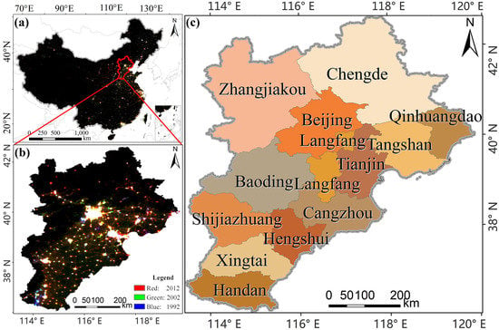
2.1. Study Area
2.2. Data Sources and Processing
2.2.1. DMSP/OLS Nighttime Light Imagery
2.2.2. Socioeconomic Data
2.2.3. High-Resolution Satellite Remote Sensing Imagery
3. Methods
3.1. Trend Analysis
3.1.1. Mann-Kendall Non-Parametric Test Method (M-K Test)
3.1.2. Standard Deviation
3.2. Construction of the Nighttime Light Indices
3.3. Correlation Analysis Method
4. Results
4.1. Analysis of the Characteristics of Artificial Lighting in the Beijing-Tianjin-Hebei Region
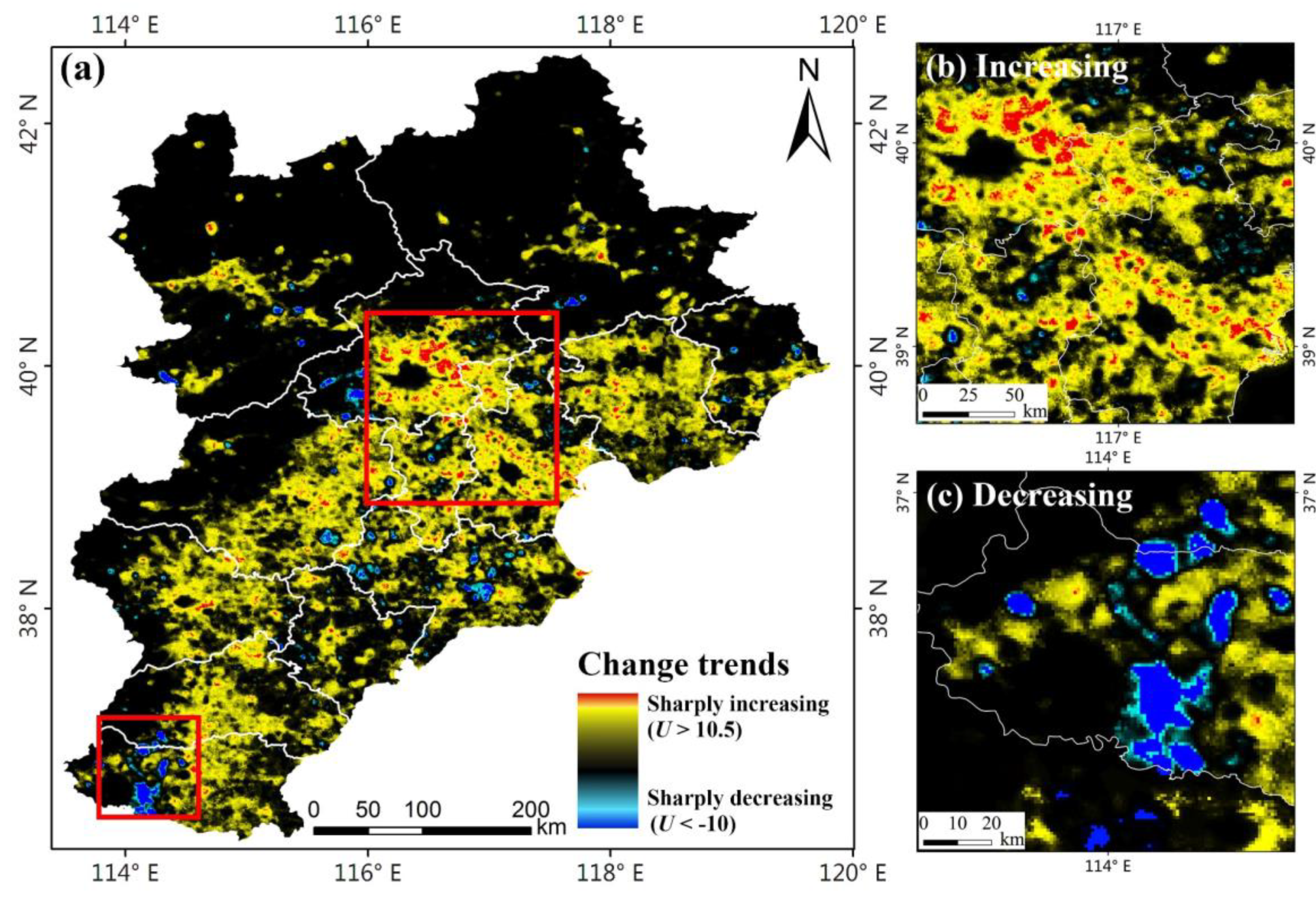
4.1.1. The Trend Analysis of Artificial Lighting
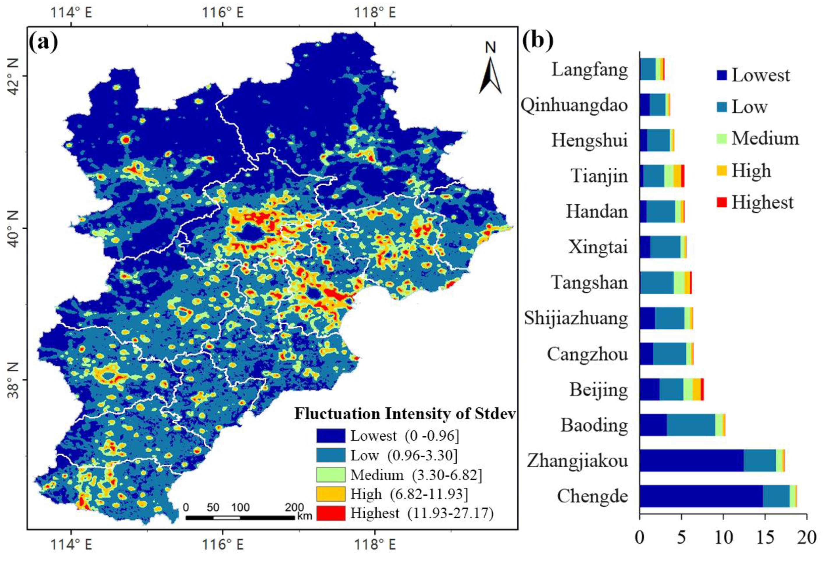
4.1.2. Change Characteristics Analysis of Artificial Lighting
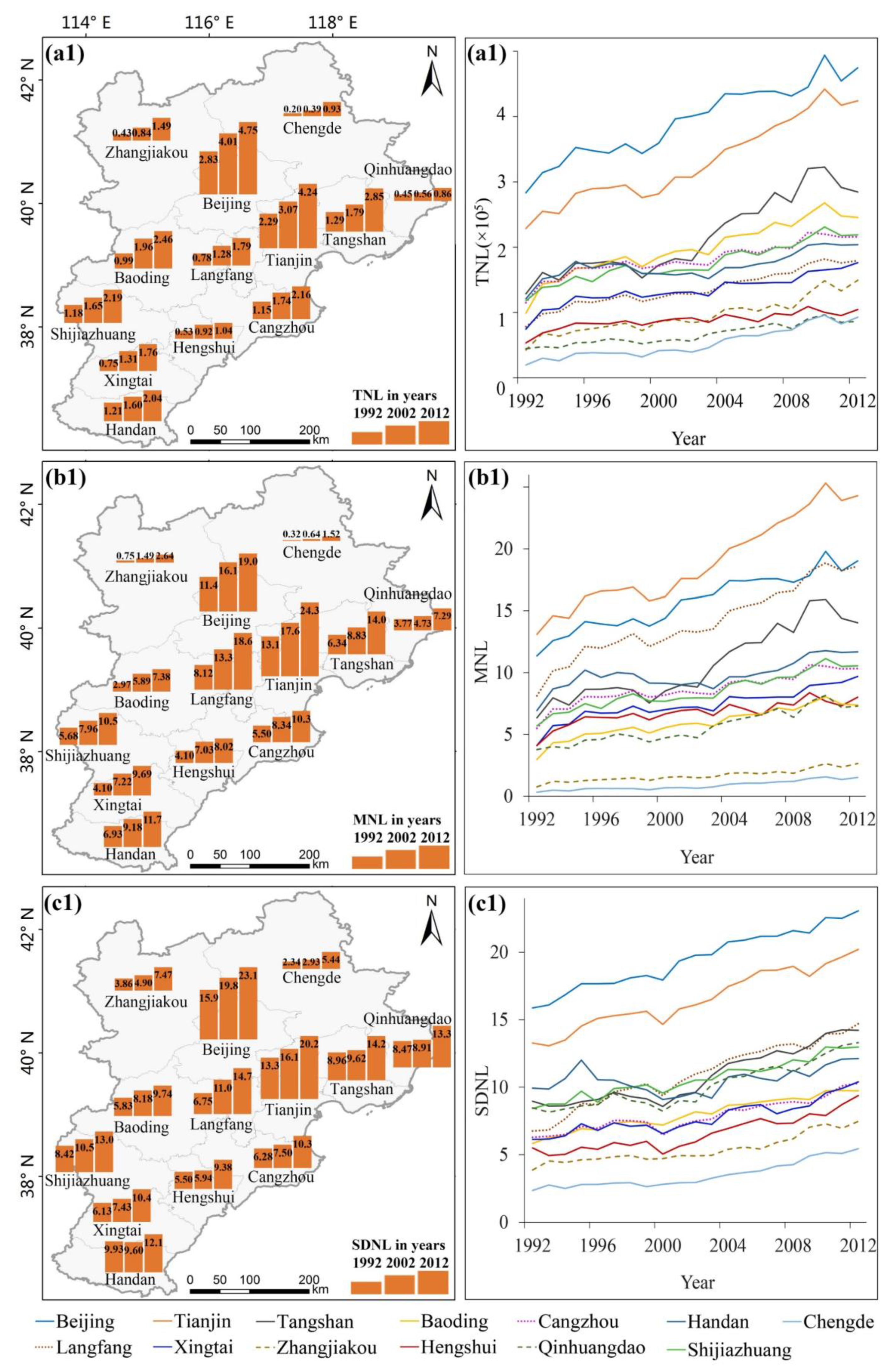
4.2. Analysis of Artificial Lighting at Prefecture-Level Cities in the Beijing-Tianjin-Hebei Region
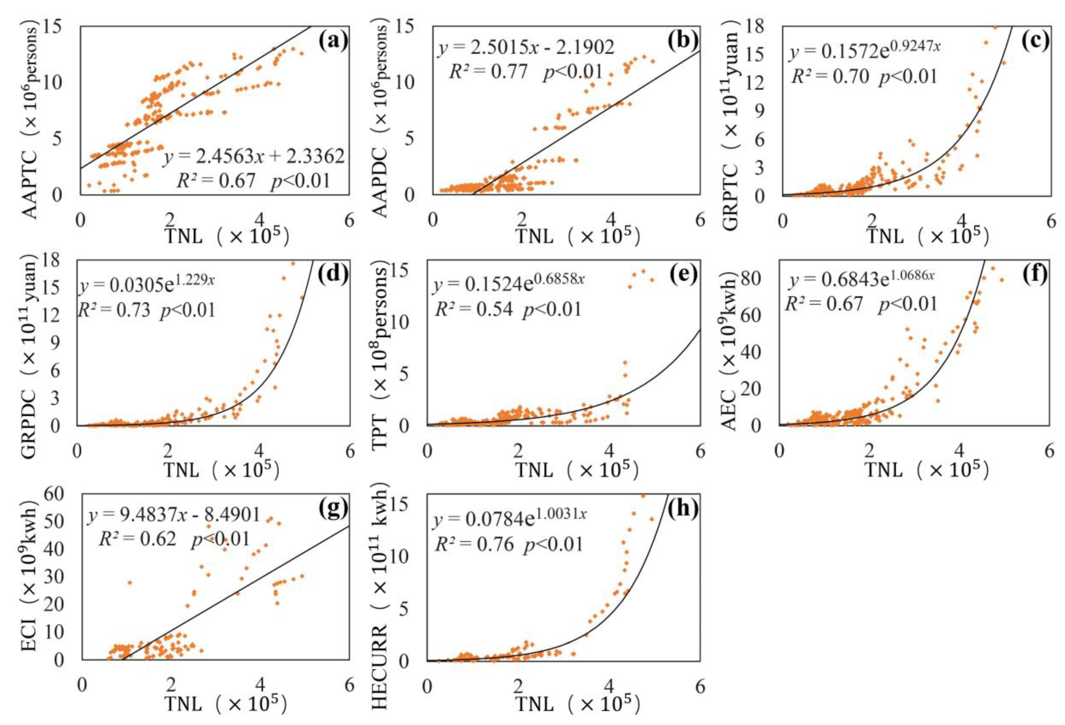
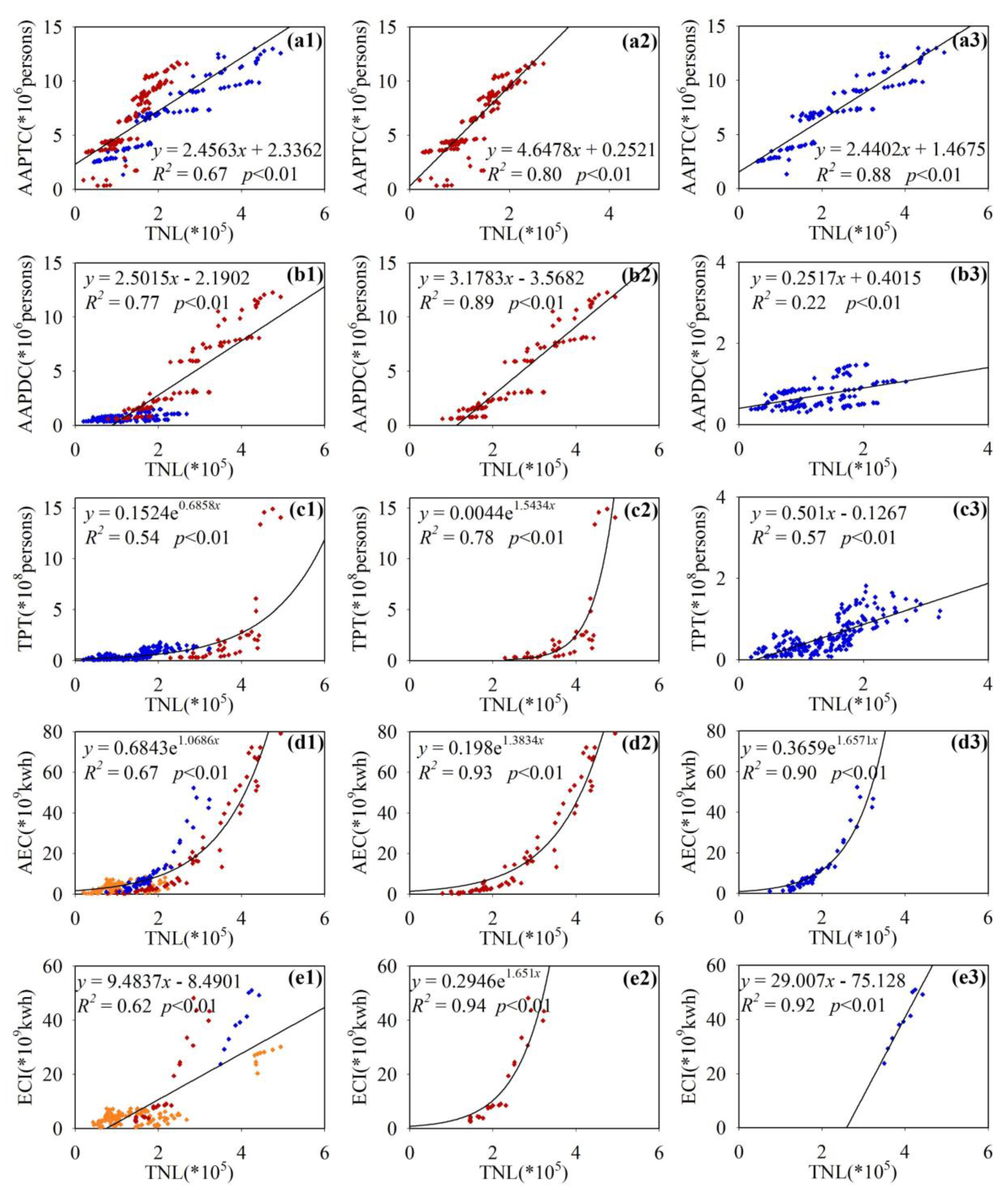
4.3. Analysis of Driving Factors of Artificial Lighting in the Beijing-Tianjin-Hebei Region
5. Discussion
6. Conclusions
Author Contributions
Funding
Acknowledgments
Conflicts of Interest
References
- Kyba, C.C.; Kuester, T.; de Miguel, A.S.; Baugh, K.; Jechow, A.; Hölker, F.; Bennie, J.; Elvidge, C.D.; Gaston, K.J.; Guanter, L. Artificially lit surface of earth at night increasing in radiance and extent. Sci. Adv. 2017, 3, e1701528. [Google Scholar] [CrossRef]
- Zhou, T. The Research of Light Pollution Problem in Urban Lighting & Design Countermeasure; Huazhong University of Science and Technology: Wuhan, China, 2004. [Google Scholar]
- Zhang, Z.; Liu, F.; Zhao, X.; Wang, X.; Shi, L.; Xu, J.; Yu, S.; Wen, Q.; Zuo, L.; Yi, L. Urban expansion in china based on remote sensing technology: A review. Chin. Geogr. Sci. 2018, 28, 727–743. [Google Scholar] [CrossRef]
- Chalkias, C.; Petrakis, M.; Psiloglou, B.; Lianou, M. Modelling of light pollution in suburban areas using remotely sensed imagery and gis. J. Environ. Manag. 2006, 79, 57–63. [Google Scholar] [CrossRef] [PubMed]
- Koo, Y.S.; Song, J.-Y.; Joo, E.-Y.; Lee, H.-J.; Lee, E.; Lee, S.-K.; Jung, K.-Y. Outdoor artificial light at night, obesity, and sleep health: Cross-sectional analysis in the koges study. Chronobiol. Int. 2016, 33, 301–314. [Google Scholar] [CrossRef] [PubMed]
- Bennie, J.; Duffy, J.P.; Davies, T.W.; Correa-Cano, M.E.; Gaston, K.J. Global trends in exposure to light pollution in natural terrestrial ecosystems. Remote Sens. 2015, 7, 2715–2730. [Google Scholar] [CrossRef]
- Kyba, C.C.; Hölker, F. Do Artificially Illuminated Skies Affect Biodiversity in Nocturnal Landscapes? Springer: Berlin, Germany, 2013. [Google Scholar]
- Hu, Z.; Hu, H.; Huang, Y. Association between nighttime artificial light pollution and sea turtle nest density along florida coast: A geospatial study using viirs remote sensing data. Environ. Pollut. 2018, 239, 30–42. [Google Scholar] [CrossRef] [PubMed]
- Kuechly, H.U.; Kyba, C.C.; Ruhtz, T.; Lindemann, C.; Wolter, C.; Fischer, J.; Hölker, F. Aerial survey and spatial analysis of sources of light pollution in berlin, germany. Remote Sens. Environ. 2012, 126, 39–50. [Google Scholar] [CrossRef]
- Wang, D.G. Thoughts and Suggestions of Establishing China’s Light Pollution Prevention and Control System; China Environmental management: Beijing, China, 2012; pp. 31–34. [Google Scholar]
- He, C.L.; Chen, J.; Shi, J.; Pan, P.; Li, Y.; Zhuo, J. The urbanization of the bohai rim region based on nighttime lighting data. J. Geogr. Sci. 2005, 60, 409–417. [Google Scholar]
- Li, X.; Elvidge, C.; Zhou, Y.; Cao, C.; Warner, T. Remote sensing of night-time light. Int. J. Remote Sens. 2017, 38, 5855–5859. [Google Scholar] [CrossRef]
- Roychowdhury, K.; Jones, S.D.; Arrowsmith, C.; Reinke, K. A comparison of high and low gain dmsp/ols satellite images for the study of socio-economic metrics. IEEE J. Sel. Top. Appl. Earth Obs. Remote Sens. 2011, 4, 35–42. [Google Scholar] [CrossRef]
- Gao, B.; Huang, Q.; He, C.; Ma, Q. Dynamics of urbanization levels in china from 1992 to 2012: Perspective from dmsp/ols nighttime light data. Remote Sens. 2015, 7, 1721–1735. [Google Scholar] [CrossRef]
- Hu, D.; Chen, S.; Qiao, K.; Cao, S. Integrating cart algorithm and multi-source remote sensing data to estimate sub-pixel impervious surface coverage: A case study from beijing municipality, china. Chin. Geogr. Sci. 2017, 27, 614–625. [Google Scholar] [CrossRef]
- Shi, K.; Chen, Y.; Yu, B.; Xu, T.; Chen, Z.; Liu, R.; Li, L.; Wu, J. Modeling spatiotemporal CO2 (carbon dioxide) emission dynamics in china from dmsp-ols nighttime stable light data using panel data analysis. Appl. Energy 2016, 168, 523–533. [Google Scholar] [CrossRef]
- Jiang, W.; He, G.; Long, T.; Liu, H. Ongoing conflict makes yemen dark: From the perspective of nighttime light. Remote Sens. 2017, 9, 798. [Google Scholar] [CrossRef]
- Jiang, W.; He, G.; Long, T.; Wang, C.; Ni, Y.; Ma, R. Assessing light pollution in china based on nighttime light imagery. Remote Sens. 2017, 9, 135. [Google Scholar] [CrossRef]
- Bennie, J.; Davies, T.W.; Duffy, J.P.; Inger, R.; Gaston, K.J. Contrasting trends in light pollution across europe based on satellite observed night time lights. Sci. Rep. 2014, 4, 3789. [Google Scholar] [CrossRef]
- Han, P.; Huang, J.; Li, R.; Wang, L.; Hu, Y.; Wang, J.; Huang, W. Monitoring trends in light pollution in china based on nighttime satellite imagery. Remote Sens. 2014, 6, 5541–5558. [Google Scholar] [CrossRef]
- Yu, B.; Shu, S.; Liu, H.; Song, W.; Wu, J.; Wang, L.; Chen, Z. Object-based spatial cluster analysis of urban landscape pattern using nighttime light satellite images: A case study of China. Int. J. Geogr. Inf. Sci. 2014, 28, 2328–2355. [Google Scholar] [CrossRef]
- Ma, T.; Zhou, Y.; Zhou, C.; Haynie, S.; Pei, T.; Xu, T. Night-time light derived estimation of spatio-temporal characteristics of urbanization dynamics using DMSP/OLS satellite data. Remote Sens. Environ. 2015, 158, 453–464. [Google Scholar] [CrossRef]
- Shi, K.; Yu, B.; Huang, Y.; Hu, Y.; Yin, B.; Chen, Z.; Chen, L.; Wu, J. Evaluating the ability of NPP-VIIRS nighttime light data to estimate the gross domestic product and the electric power consumption of China at multiple scales: A comparison with DMSP-OLS data. Remote Sens. 2014, 6, 1705–1724. [Google Scholar] [CrossRef]
- Shi, K.; Chen, Y.; Yu, B.; Xu, T.; Yang, C.; Li, L.; Huang, C.; Chen, Z.; Liu, R.; Wu, J. Detecting spatiotemporal dynamics of global electric power consumption using dmsp-ols nighttime stable light data. Appl. Energy 2016, 184, 450–463. [Google Scholar] [CrossRef]
- Zhuo, L.; Ichinose, T.; Zheng, J.; Chen, J.; Shi, P.; Li, X. Modelling the population density of China at the pixel level based on DMSP/OLS non-radiance-calibrated night-time light images. Int. J. Remote Sens. 2009, 30, 1003–1018. [Google Scholar] [CrossRef]
- Xu, Y.; Ye, Z.; Wang, Y.; Wang, C.; Sun, C. Evaluating the influence of road lighting on traffic safety at accesses using an artificial neural network. Traffic Inj. Prev. 2018, 19, 601–606. [Google Scholar] [CrossRef] [PubMed]
- He, Y. Tourism Spatial Structure Evolution of Capital Region Based on High-Speed Railway; Beijing Jiaotong University: Beijing, China, 2016. [Google Scholar]
- Yang, Y.; Huang, Q.X.; Zhang, L.L. The spatial-temporal measurement on the land urbanization level using DMSP/OLS nighttime light data—A case study of bohai rim. Econ. Geogr. 2015, 35, 141–148. (In Chinese) [Google Scholar]
- Elvidge, C.; Ziskin, D.; Baugh, K.; Tuttle, B.; Ghosh, T.; Pack, D.; Erwin, E.; Zhizhin, M. A fifteen year record of global natural gas flaring derived from satellite data. Energies 2009, 2, 595–622. [Google Scholar] [CrossRef]
- Liu, Z.; He, C.; Zhang, Q.; Huang, Q.; Yang, Y. Extracting the dynamics of urban expansion in china using DMSP-OLS nighttime light data from 1992 to 2008. Landsc. Urban Plan. 2012, 106, 62–72. [Google Scholar] [CrossRef]
- Elvidge, C.D.; Cinzano, P.; Pettit, D.; Arvesen, J.; Sutton, P.; Small, C.; Nemani, R.; Longcore, T.; Rich, C.; Safran, J. The nightsat mission concept. Int. J. Remote Sens. 2007, 28, 2645–2670. [Google Scholar] [CrossRef]
- Chu, H.-J.; Yang, C.-H.; Chou, C.C. Adaptive non-negative geographically weighted regression for population density estimation based on nighttime light. ISPRS Int. J. Geo-Inf. 2019, 8, 26. [Google Scholar] [CrossRef]
- Wu, J.; Wang, Z.; Li, W.; Peng, J. Exploring factors affecting the relationship between light consumption and gdp based on DMSP/OLS nighttime satellite imagery. Remote Sens. Environ. 2013, 134, 111–119. [Google Scholar] [CrossRef]
- Huang, Q.; He, C.; Gao, B.; Yang, Y.; Liu, Z.; Zhao, Y.; Dou, Y. Detecting the 20 year city-size dynamics in china with a rank clock approach and DMSP/OLS nighttime data. Landsc. Urban Plan. 2015, 137, 138–148. [Google Scholar] [CrossRef]
- Jiang, W.; He, G.; Liu, H. Modeling regional socio-economic parameters based on comparison of NPP/VIIRS and DMSP/OLS nighttime light imagery. Remote Sens. Inf. 2016, 31, 28–34. [Google Scholar]
- Smith, L.C. Trends in Russian arctic river-ice formation and breakup, 1917 to 1994. Phys. Geogr. 2000, 21, 46–56. [Google Scholar] [CrossRef]
- Xu, Z.; Chen, Y.; Li, J. Impact of climate change on water resources in the tarim river basin. Water Resour. Manag. 2004, 18, 439–458. [Google Scholar] [CrossRef]
- Yan, E.; Lin, H.; Dang, Y.; Xia, C. The spatiotemporal changes of vegetation cover in Beijing-Tianjin sandstorm source control region during 2000–2012. Acta Ecol. Sin. 2014, 34, 5007–5020. [Google Scholar]
- Gaston, K.J.; Bennie, J.; Davies, T.W.; Hopkins, J. The ecological impacts of nighttime light pollution: A mechanistic appraisal. Biol. Rev. 2013, 88, 912–927. [Google Scholar] [CrossRef]
- Kloog, I.; Haim, A.; Stevens, R.G.; Portnov, B.A. Global co-distribution of light at night (lan) and cancers of prostate, colon, and lung in men. Chronobiol. Int. 2009, 26, 108–125. [Google Scholar] [CrossRef]
- Sutton, P.; Roberts, D.; Elvidge, C.; Meij, H. A comparison of nighttime satellite imagery and population density for the continental united states. Photogramm. Eng. Remote Sens. 1997, 63, 1303–1313. [Google Scholar]
- Yu, N.; De Jong, M.; Storm, S.; Mi, J. Spatial spillover effects of transport infrastructure: Evidence from Chinese regions. J. Transp. Geogr. 2013, 28, 56–66. [Google Scholar] [CrossRef]
- Wang, X. Chinese Industry and Beijing-Tianjin-Hebei Region Collaborative Development during the “Thirteenth Five-Year Plan” Period: A Review of the Fourth China Industrial Development Forum; China’s Industrial Economics: Beijing, China, 2016; pp. 146–150. (In Chinese) [Google Scholar]
- Zou, Y.; Peng, H.; Liu, G.; Yang, K.; Xie, Y.; Weng, Q. Monitoring urban clusters expansion in the middle reaches of the yangtze river, China, using time-series nighttime light images. Remote Sens. 2017, 9, 1007. [Google Scholar] [CrossRef]
- Wang, M.; He, G.; Zhang, Z.; Wang, G.; Zhang, Z.; Cao, X.; Wu, Z.; Liu, X. Comparison of spatial interpolation and regression analysis models for an estimation of monthly near surface air temperature in China. Remote Sens. 2017, 9, 1278. [Google Scholar] [CrossRef]
- Chen, Z.; Yu, B.; Song, W.; Liu, H.; Wu, Q.; Shi, K.; Wu, J. A new approach for detecting urban centers and their spatial structure with nighttime light remote sensing. IEEE Trans. Geosci. Remote Sens. 2017, 55, 6305–6319. [Google Scholar] [CrossRef]
- Levin, N.; Johansen, K.; Hacker, J.M.; Phinn, S. A new source for high spatial resolution night time images—The EROS-B commercial satellite. Remote Sens. Environ. 2014, 149, 1–12. [Google Scholar] [CrossRef]
- Zheng, Q.; Weng, Q.; Huang, L.; Wang, K.; Deng, J.; Jiang, R.; Ye, Z.; Gan, M. A new source of multi-spectral high spatial resolution night-time light imagery—JL1-3B. Remote Sens. Environ. 2018, 215, 300–312. [Google Scholar] [CrossRef]
- Li, X.; Li, X.; Li, D.; He, X.; Jendryke, M. A preliminary investigation of luojia-1 night-time light imagery. Remote Sens. Lett. 2019, 10, 526–535. [Google Scholar] [CrossRef]
- Jiang, W.; He, G.; Long, T.; Guo, H.; Yin, R.; Leng, W.; Liu, H.; Wang, G. Potentiality of using luojia 1-01 nighttime light imagery to investigate artificial light pollution. Sensors 2018, 18, 2900. [Google Scholar] [CrossRef] [PubMed]
- Li, X.; Zhao, L.; Li, D.; Xu, H. Mapping urban extent using luojia 1-01 nighttime light imagery. Sensors 2018, 18, 3665. [Google Scholar] [CrossRef] [PubMed]


| Typical Area | Sensor | Resolution (m) | Acquisition Time | Cloud Cover (%) |
|---|---|---|---|---|
| a1 | IKONOS | 0.8 | 01-28-2001 | 0.0 |
| a2 | Pléiades-1 | 0.5 | 10-13-2012 | 0.0 |
| b1 | QuickBird | 0.6 | 04-24-2002 | 0.0 |
| b2 | WorldView-2 | 0.5 | 09-14-2012 | 4.0 |
| c1 | QuickBird | 0.6 | 08-28-2004 | 0.0 |
| c2 | WorldView-2 | 0.5 | 11-23-2011 | 0.0 |
| d1 | QuickBird | 0.6 | 11-16-2003 | 0.0 |
| d2 | GeoEye-1 | 0.5 | 12-31-2012 | 0.0 |
| e1 | QuickBird | 0.6 | 05-04-2014 | 0.0 |
| e2 | KOMPSAT-2 | 1 | 03-03-2013 | 0.0 |
| f1 | QuickBird | 0.6 | 06-30-2005 | 3.0 |
| f2 | Pléiades-1 | 0.5 | 08-22-2012 | 0.0 |
| g1 | QuickBird | 0.6 | 04-24-2008 | 2.0 |
| g2 | WorldView-2 | 0.5 | 05-04-2014 | 1.0 |
| h1 | QuickBird | 0.6 | 08-28-2014 | 0.0 |
| h2 | GeoEye-1 | 0.45 | 05-31-2012 | 1.0 |
| i1 | IKONOS | 0.8 | 06-14-2006 | 0.0 |
| i2 | GeoEye-1 | 0.48 | 09-29-2012 | 0.0 |
| j1 | QuickBird | 0.6 | 09-07-2004 | 0.0 |
| j2 | WorldView-2 | 0.5 | 12-11-2013 | 0.0 |
| k1 | QuickBird | 0.6 | 05-22-2002 | 0.0 |
| k2 | GeoEye-1 | 0.49 | 08-19-2013 | 0.0 |
| l1 | QuickBird | 0.6 | 03-24-2002 | 0.0 |
| l2 | WorldView-2 | 0.5 | 04-06-2013 | 0.0 |
© 2019 by the authors. Licensee MDPI, Basel, Switzerland. This article is an open access article distributed under the terms and conditions of the Creative Commons Attribution (CC BY) license (http://creativecommons.org/licenses/by/4.0/).
Share and Cite
Leng, W.; He, G.; Jiang, W. Investigating the Spatiotemporal Variability and Driving Factors of Artificial Lighting in the Beijing-Tianjin-Hebei Region Using Remote Sensing Imagery and Socioeconomic Data. Int. J. Environ. Res. Public Health 2019, 16, 1950. https://doi.org/10.3390/ijerph16111950
Leng W, He G, Jiang W. Investigating the Spatiotemporal Variability and Driving Factors of Artificial Lighting in the Beijing-Tianjin-Hebei Region Using Remote Sensing Imagery and Socioeconomic Data. International Journal of Environmental Research and Public Health. 2019; 16(11):1950. https://doi.org/10.3390/ijerph16111950
Chicago/Turabian StyleLeng, Wanchun, Guojin He, and Wei Jiang. 2019. "Investigating the Spatiotemporal Variability and Driving Factors of Artificial Lighting in the Beijing-Tianjin-Hebei Region Using Remote Sensing Imagery and Socioeconomic Data" International Journal of Environmental Research and Public Health 16, no. 11: 1950. https://doi.org/10.3390/ijerph16111950
APA StyleLeng, W., He, G., & Jiang, W. (2019). Investigating the Spatiotemporal Variability and Driving Factors of Artificial Lighting in the Beijing-Tianjin-Hebei Region Using Remote Sensing Imagery and Socioeconomic Data. International Journal of Environmental Research and Public Health, 16(11), 1950. https://doi.org/10.3390/ijerph16111950