Mosaicking Opportunistically Acquired Very High-Resolution Helicopter-Borne Images over Drifting Sea Ice Using COTS Sensors


Abstract
1. Introduction
2. Description of Study Area
3. Materials and Methods
3.1. Installation of Imaging Equipment on Helicopter
3.2. Preprocessing of Acquired Helicopter-Borne Images
3.3. Compensation of the Effect from Sea Ice Drift in Imaging Locations
3.4. Image Mosaicking and Accuracy Assessment
4. Results
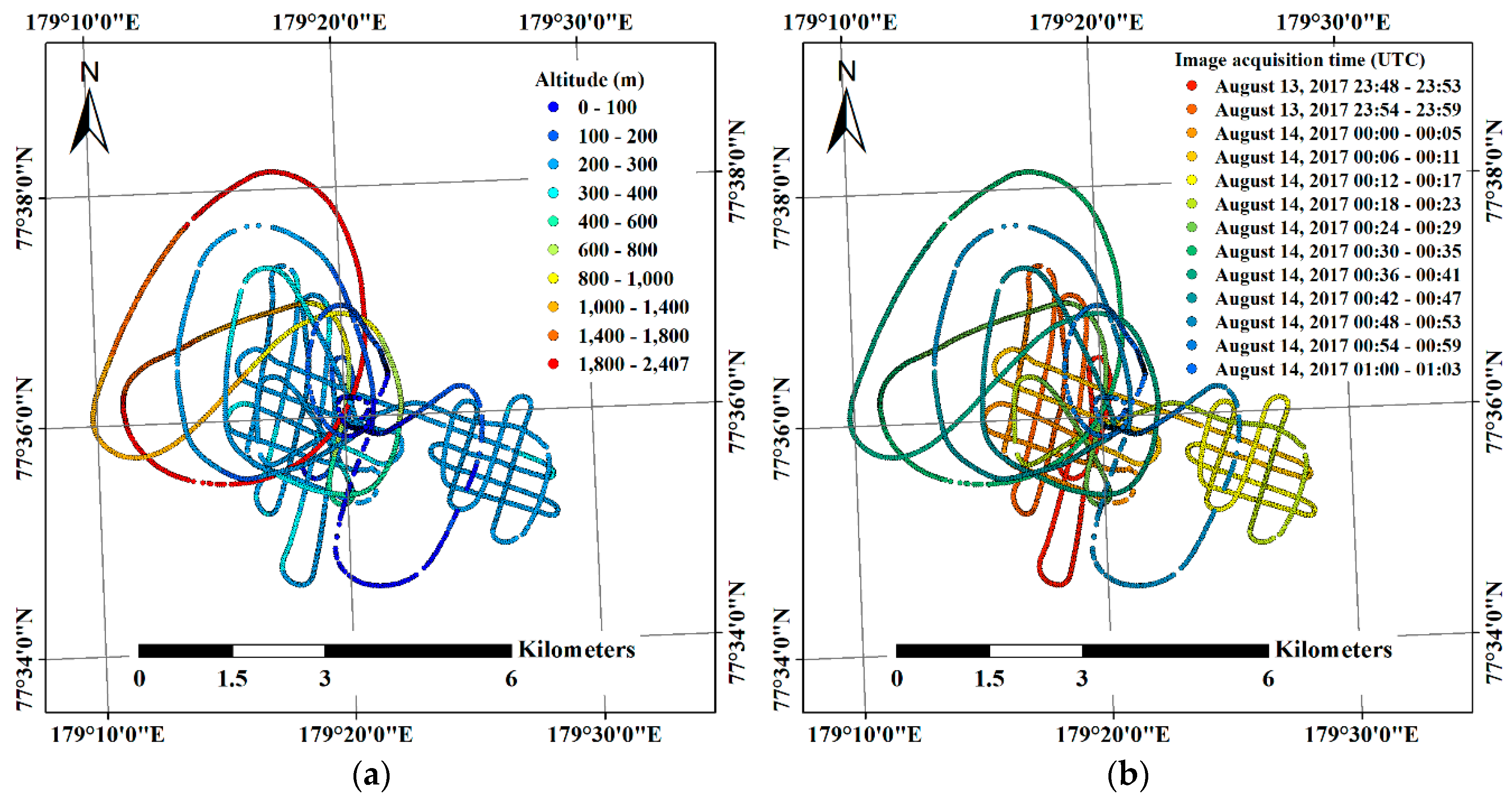
4.1. Results of Helicopter-Borne Image Acquisition
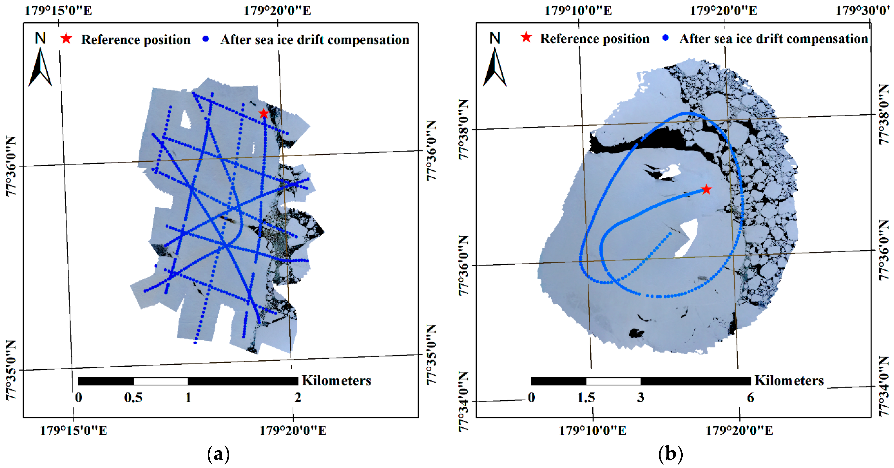
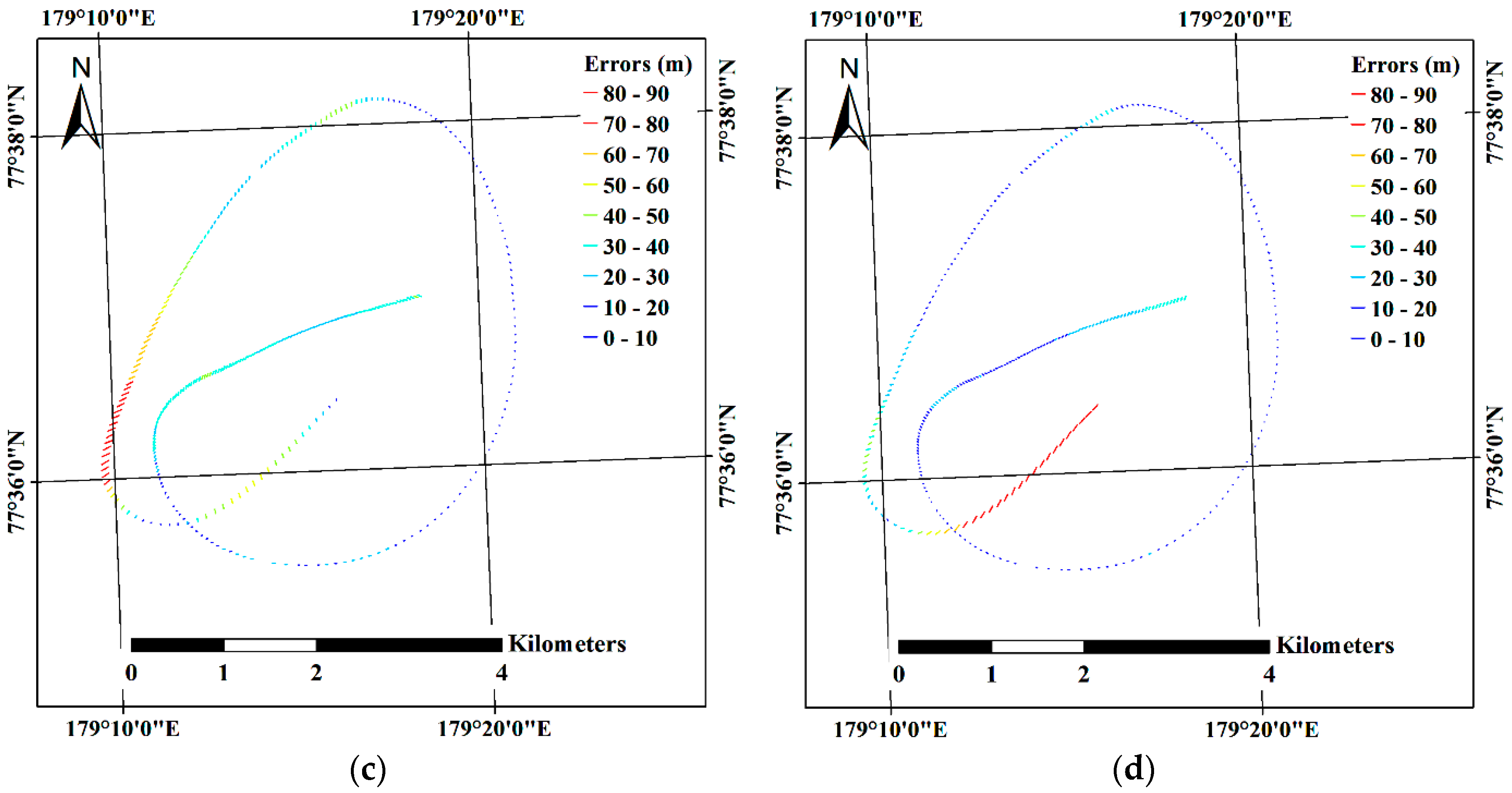
4.2. Compensation of the Effect from Sea Ice Drift
4.3. Image Mosaicking Results and Evaluation of Errors
4.4. Comparison between Helicopter-Borne Mosaicked VHR Image and Satellite SAR Image
5. Discussion
6. Conclusions
Author Contributions
Funding
Conflicts of Interest
References
- Hall, R.J.; Hughes, N.; Wadhams, P. A systematic method of obtaining ice concentration measurements from ship-based observations. Cold Reg. Sci. Technol. 2002, 34, 97–102. [Google Scholar] [CrossRef]
- Massom, R.A.; Worby, A.; Lytle, V.; Markus, T.; Allison, I.; Scambos, T.; Enomoto, H.; Tamura, T.; Tateyama, K.; Haran, T.; et al. ARISE (Antarctic Remote Ice Sensing Experiment) in the East 2003: Validation of satellite-derived sea-ice data products. Ann. Glaciol. 2006, 44, 288–296. [Google Scholar] [CrossRef]
- Baldwin, D.; Tschudi, M.; Pacifici, F.; Liu, Y. Validation of Suomi-NPP VIIRS sea ice concentration with very high-resolution satellite and airborne camera imagery. ISPRS J. Photogramm. Remote Sens. 2017, 130, 122–138. [Google Scholar] [CrossRef]
- Li, L.; Ke, C.; Xie, H.; Lei, R.; Tao, A. Aerial observations of sea ice and melt ponds near the North Pole during CHINARE2010. Acta Oceanol. Sin. 2017, 36, 64–72. [Google Scholar] [CrossRef]
- Divine, D.V.; Pedersen, C.A.; Karlsen, T.I.; Aas, H.F.; Granskog, M.A.; Hudson, S.R.; Gerland, S. Photogrammetric retrieval and analysis of small scale sea ice topography during summer melt. Cold Reg. Sci. Technol. 2016, 129, 77–84. [Google Scholar] [CrossRef]
- Yitayew, T.G.; Dierking, W.; Divine, D.V.; Eltoft, T.; Ferro-Famil, L.; Rosel, A.; Negrel, J. Validation of Sea-Ice Topographic Heights Derived from TanDEM-X Interferometric SAR Data With Results From Laser Profiler and Photogrammetry. IEEE Trans. Geosci. Remote Sens. 2018, 56, 6504–6520. [Google Scholar] [CrossRef]
- Rösel, A.; Kaleschke, L.; Birnbaum, G. Melt ponds on Arctic sea ice determined from MODIS satellite data using an artificial neural network. Cryosphere 2012, 6, 431–446. [Google Scholar] [CrossRef]
- Istomina, L.; Heygster, G.; Huntemann, M.; Schwarz, P.; Birnbaum, G.; Scharien, R.; Polashenski, C.; Perovich, D.; Zege, E.; Malinka, A.; et al. Melt pond fraction and spectral sea ice albedo retrieval from MERIS data—Part 1: Validation against in situ, aerial, and ship cruise data. Cryosphere 2015, 9, 1551–1566. [Google Scholar] [CrossRef]
- Lu, X.; Hu, Y.; Liu, Z.; Rodier, S.; Vaughan, M.; Lucker, P.; Trepte, C.; Pelon, J. Observations of Arctic snow and sea ice cover from CALIOP lidar measurements. Remote Sens. Environ. 2017, 194, 248–263. [Google Scholar] [CrossRef]
- Perovich, D.K. Seasonal evolution of the albedo of multiyear Arctic sea ice. J. Geophys. Res. 2002, 107, SHE 20-1–SHE 20-13. [Google Scholar] [CrossRef]
- Petrich, C.; Eicken, H.; Polashenski, C.M.; Sturm, M.; Harbeck, J.P.; Perovich, D.K.; Finnegan, D.C. Snow dunes: A controlling factor of melt pond distribution on Arctic sea ice. J. Geophys. Res. Ocean. 2012, 117. [Google Scholar] [CrossRef]
- Polashenski, C.; Perovich, D.; Courville, Z. The mechanisms of sea ice melt pond formation and evolution. J. Geophys. Res. Ocean. 2012, 117. [Google Scholar] [CrossRef]
- Balsa-Barreiro, J.; Lerma, J.L. Empirical study of variation in lidar point density over different land covers. Int. J. Remote Sens. 2014, 35, 3372–3383. [Google Scholar] [CrossRef]
- Farrell, S.L.; Kurtz, N.; Connor, L.N.; Elder, B.C.; Leuschen, C.; Markus, T.; McAdoo, D.C.; Panzer, B.; Richter-Menge, J.; Sonntag, J.G. A First Assessment of IceBridge Snow and Ice Thickness Data Over Arctic Sea Ice. IEEE Trans. Geosci. Remote Sens. 2012, 50, 2098–2111. [Google Scholar] [CrossRef]
- Assmy, P.; Ehn, J.K.; Fernandez-Mendez, M.; Hop, H.; Katlein, C.; Sundfjord, A.; Bluhm, K.; Daase, M.; Engel, A.; Fransson, A.; et al. Floating ice-algal aggregates below melting arctic sea ice. PLoS ONE 2013, 8, e76599. [Google Scholar] [CrossRef] [PubMed]
- Onana, V.-D.-P.; Kurtz, N.T.; Farrell, S.L.; Koenig, L.S.; Studinger, M.; Harbeck, J.P. A Sea-Ice Lead Detection Algorithm for Use with High-Resolution Airborne Visible Imagery. IEEE Trans. Geosci. Remote Sens. 2013, 51, 38–56. [Google Scholar] [CrossRef]
- Wang, X.; Guan, F.; Liu, J.; Xie, H.; Ackley, S. An improved approach of total freeboard retrieval with IceBridge Airborne Topographic Mapper (ATM) elevation and Digital Mapping System (DMS) images. Remote Sens. Environ. 2016, 184, 582–594. [Google Scholar] [CrossRef]
- Duncan, K.; Farrell, S.L.; Connor, L.N.; Richter-Menge, J.; Hutchings, J.K.; Dominguez, R. High-resolution airborne observations of sea-ice pressure ridge sail height. Ann. Glaciol. 2018, 59, 137–147. [Google Scholar] [CrossRef]
- Parmiggiani, F.; Moctezuma-Flores, M.; Wadhams, P.; Aulicino, G. Image processing for pancake ice detection and size distribution computation. Int. J. Remote Sens. 2018. [Google Scholar] [CrossRef]
- Alberello, A.; Onorato, M.; Bennetts, L.; Vichi, M.; Eayrs, C.; MacHutchon, K.; Toffoli, A. Brief communication: Pancake ice floe size distribution during the winter expansion of the Antarctic marginal ice zone. Cryosphere 2019, 13, 41–48. [Google Scholar] [CrossRef]
- Kurtz, N.T.; Farrell, S.L.; Studinger, M.; Galin, N.; Harbeck, J.P.; Lindsay, R.; Onana, V.D.; Panzer, B.; Sonntag, J.G. Sea ice thickness, freeboard, and snow depth products from Operation IceBridge airborne data. Cryosphere 2013, 7, 1035–1056. [Google Scholar] [CrossRef]
- Weissling, B.; Ackley, S.; Wagner, P.; Xie, H. EISCAM—Digital image acquisition and processing for sea ice parameters from ships. Cold Reg. Sci. Technol. 2009, 57, 49–60. [Google Scholar] [CrossRef]
- Inoue, J.; Curry, J.A.; Maslanik, J.A. Application of Aerosondes to Melt-Pond Observations over Arctic Sea Ice. J. Atmos. Ocean. Technol. 2008, 25, 327–334. [Google Scholar] [CrossRef]
- Tschudi, M.A.; Maslanik, J.A.; Perovich, D.K. Derivation of melt pond coverage on Arctic sea ice using MODIS observations. Remote Sens. Environ. 2008, 112, 2605–2614. [Google Scholar] [CrossRef]
- Haas, C.; Pfaffling, A.; Hendricks, S.; Rabenstein, L.; Etienne, J.-L.; Rigor, I. Reduced ice thickness in Arctic Transpolar Drift favors rapid ice retreat. Geophys. Res. Lett. 2008, 35. [Google Scholar] [CrossRef]
- Haas, C.; Lobach, J.; Hendricks, S.; Rabenstein, L.; Pfaffling, A. Helicopter-borne measurements of sea ice thickness, using a small and lightweight, digital EM system. J. Appl. Geophys. 2009, 67, 234–241. [Google Scholar] [CrossRef]
- Goebell, S. Comparison of coincident snow-freeboard and sea ice thickness profiles derived from helicopter-borne laser altimetry and electromagnetic induction sounding. J. Geophys. Res. 2011, 116. [Google Scholar] [CrossRef]
- Rabenstein, L.; Krumpen, T.; Hendricks, S.; Koeberle, C.; Haas, C.; Hoelemann, J.A. A combined approach of remote sensing and airborne electromagnetics to determine the volume of polynya sea ice in the Laptev Sea. Cryosphere Discuss. 2013, 7, 441–473. [Google Scholar] [CrossRef]
- Hendricks, S.; Gerland, S.; Smedsrud, L.H.; Haas, C.; Pfaffhuber, A.A.; Nilsen, F. Sea-ice thickness variability in Storfjorden, Svalbard. Ann. Glaciol. 2017, 52, 61–68. [Google Scholar] [CrossRef]
- Kern, S.; Gade, M.; Haas, C.; Pfaffling, A. Retrieval of thin-ice thickness using the L-band polarization ratio measured by the helicopter-borne scatterometer Heliscat. Ann. Glaciol. 2006, 44, 275–280. [Google Scholar] [CrossRef]
- Girod, L.; Nuth, C.; Kääb, A.; Etzelmüller, B.; Kohler, J. Terrain changes from images acquired on opportunistic flights by SfM photogrammetry. Cryosphere 2017, 11, 827–840. [Google Scholar] [CrossRef]
- Johansson, A.M.; King, J.A.; Doulgeris, A.P.; Gerland, S.; Singha, S.; Spreen, G.; Busche, T. Combined observations of Arctic sea ice with near-coincident colocated X-band, C-band, and L-band SAR satellite remote sensing and helicopter-borne measurements. J. Geophys. Res. Ocean. 2017, 122, 669–691. [Google Scholar] [CrossRef]
- King, J.; Skourup, H.; Hvidegaard, S.M.; Rösel, A.; Gerland, S.; Spreen, G.; Polashenski, C.; Helm, V.; Liston, G.E. Comparison of Freeboard Retrieval and Ice Thickness Calculation From ALS, ASIRAS, and CryoSat-2 in the Norwegian Arctic to Field Measurements Made During the N-ICE2015 Expedition. J. Geophys. Res. Ocean. 2018, 123, 1123–1141. [Google Scholar] [CrossRef]
- Cavalieri, D.; Parkinson, C.; Gloersen, P.; Zwally, H.J. Sea Ice Concentrations from Nimbus-7 SMMR and DMSP SSM/I-SSMIS Passive Microwave Data; Version 1; NASA DAAC at the National Snow and Ice Data Center: Boulder, CO, USA, 1996; Available online: http://dx.doi.org/10.5067/8GQ8LZQVL0VL (accessed on 6 May 2018).
- Avellar, G.S.; Pereira, G.A.; Pimenta, L.C.; Iscold, P. Multi-UAV Routing for Area Coverage and Remote Sensing with Minimum Time. Sensors 2015, 15, 27783–27803. [Google Scholar] [CrossRef]
- Little, T.A. Establishing Acceptance Criteria for Analytical Methods. Biopharm. Int. 2016, 29, 44–48. [Google Scholar]
- Lindsay, R.; Stern, H. The RADARSAT geophysical processor system: Quality of sea ice trajectory and deformation estimates. J. Atmos. Ocean. Technol. 2003, 20, 1333–1347. [Google Scholar] [CrossRef]
- Hyun, C.U.; Kim, H.C. A Feasibility Study of Sea Ice Motion and Deformation Measurements Using Multi-Sensor High-Resolution Optical Satellite Images. Remote Sens. 2017, 9, 930. [Google Scholar] [CrossRef]
- Javernick, L.; Brasington, J.; Caruso, B. Modeling the topography of shallow braided rivers using Structure-from-Motion photogrammetry. Geomorphology 2014, 213, 166–182. [Google Scholar] [CrossRef]
- Leon, J.X.; Roelfsema, C.M.; Saunders, M.I.; Phinn, S.R. Measuring coral reef terrain roughness using ‘Structure-from-Motion’ close-range photogrammetry. Geomorphology 2015, 242, 21–28. [Google Scholar] [CrossRef]
- Nolan, M.; Larsen, C.; Sturm, M. Mapping snow depth from manned aircraft on landscape scales at centimeter resolution using structure-from-motion photogrammetry. Cryosphere 2015, 9, 1445–1463. [Google Scholar] [CrossRef]
- Piermattei, L.; Carturan, L.; Guarnieri, A. Use of terrestrial photogrammetry based on structure-from-motion for mass balance estimation of a small glacier in the Italian alps. Earth Surf. Process. Landf. 2015, 40, 1791–1802. [Google Scholar] [CrossRef]
- Agisoft LLC. AgiSoft PhotoScan User Manual; Professional Edition v.1.4; Agisoft LLC: St. Petersburg, Russia, 2018. [Google Scholar]
- Lee, J.-S. Refined filtering of image noise using local statistics. Comput. Gr. Image Process. 1981, 15, 380–389. [Google Scholar] [CrossRef]
- Ressel, R.; Singha, S.; Lehner, S.; Rösel, A.; Spreen, G. Investigation into Different Polarimetric Features for Sea Ice Classification Using X-Band Synthetic Aperture Radar. IEEE J. Sel. Top. Appl. Earth Obs. Remote Sens. 2016, 9, 3131–3143. [Google Scholar] [CrossRef]
- Breit, H.; Fritz, T.; Balss, U.; Lachaise, M.; Niedermeier, A.; Vonavka, M. TerraSAR-X SAR Processing and Products. IEEE Trans. Geosci. Remote Sens. 2010, 48, 727–740. [Google Scholar] [CrossRef]
- Zitova, B.; Flusser, J. Image registration methods: A survey. Image Vis. Comput. 2003, 21, 977–1000. [Google Scholar] [CrossRef]
- Liu, Y.; Zheng, X.; Ai, G.; Zhang, Y.; Zuo, Y. Generating a High-Precision True Digital Orthophoto Map Based on UAV Images. ISPRS Int. J. Geo-Inf. 2018, 7. [Google Scholar] [CrossRef]
- Martínez-Carricondo, P.; Agüera-Vega, F.; Carvajal-Ramírez, F.; Mesas-Carrascosa, F.-J.; García-Ferrer, A.; Pérez-Porras, F.-J. Assessment of UAV-photogrammetric mapping accuracy based on variation of ground control points. Int. J. Appl. Earth Obs. Geoinf. 2018, 72, 1–10. [Google Scholar] [CrossRef]


| Helicopter-Borne Imaging Setup | Specifications |
|---|---|
| Digital camera | Canon EOS M6 |
| Image acquisition interval | 1 s |
| Imaging mode | Aperture priority mode |
| Sensor | 24 mega-pixel Advanced Photo System type-C (APS-C) |
| Focal length | 22 mm (35 mm equivalent focal length to full frame sensor) |
| Aperture | F11 |
| Shutter speed | Varies between 1/1000 and 1/3200 |
| ISO | 400 |
| Satellite Dataset | Specifications |
|---|---|
| Imaging mode | StripMap |
| Acquisition date and time | 16 August 2017 18:49:52 (UTC) |
| Centre frequency | 9.65 GHz (X band) |
| Polarization | HH |
| Spatial resolution | 3 m |
| Swath width | 15 km |
| Helicopter-borne VHR Image Acquisition | Specifications |
|---|---|
| Number of acquired images | 4041 |
| Start time of image acquisition | 13 August 2017 23:48:37.65 (UTC) |
| End time of image acquisition | 14 August 2017 01:03:00.10 (UTC) |
| Duration of image acquisition | 1 h 14 min 22.45 s |
| Altitude of imaging location | Up to 2407 m |
| Image Subset | Number of Images | Imaging Duration |
|---|---|---|
| Subset I | 664 | 55 min 38.75 s (13 August 2017 23:50:39.70–14 August 2017 00:46:18.45) |
| Subset II | 324 | 11 min 0 s (14 August 2017 00:27:47.15–14 August 2017 00:38:47.15) |
| Image Subset | Effect from Sea Ice Drift | X Error (m) | Y Error (m) | XY Error (m) | Z Error (m) | Total Error (m) |
|---|---|---|---|---|---|---|
| Subset I | Before compensation | 188.4 | 150.7 | 241.2 | 8.1 | 241.4 |
| After compensation | 33.5 | 36.5 | 49.6 | 5.5 | 49.9 | |
| Subset II | Before compensation | 26.5 | 24.4 | 36.0 | 13.7 | 38.5 |
| After compensation | 18.9 | 20.2 | 27.6 | 9.4 | 29.2 |
| No | UTM Coordinates of CPs in Mosaicked VHR Image | UTM Coordinates of CPs in SAR Image | Residuals after Transformation (m) | RMS Error (m) | |||
|---|---|---|---|---|---|---|---|
| X (m E) | Y (m N) | X (m E) | Y (m N) | X (m E) | Y (m N) | ||
| 1 | 550,987.0 | 8,625,212.1 | 550,800.3 | 8,625,026.1 | 0.0 | 1.7 | 1.7 |
| 2 | 551,569.4 | 8,622,003.6 | 551,762.8 | 8,621,946.2 | 1.3 | 0.8 | 1.5 |
| 3 | 552,215.5 | 8,621,645.7 | 552,440.4 | 8,621,672.7 | 1.2 | 0.2 | 1.2 |
| 4 | 551,888.9 | 8,622,821.1 | 551,973.2 | 8,622,784.8 | −2.7 | −1.9 | 3.3 |
| 5 | 550,237.3 | 8,621,463.4 | 550,518.8 | 8,621,253.3 | −0.5 | 0.0 | 0.5 |
| 6 | 548,945.4 | 8,625,968.4 | 548,704.8 | 8,625,518.4 | 0.6 | −0.6 | 0.9 |
© 2019 by the authors. Licensee MDPI, Basel, Switzerland. This article is an open access article distributed under the terms and conditions of the Creative Commons Attribution (CC BY) license (http://creativecommons.org/licenses/by/4.0/).
Share and Cite
Hyun, C.-U.; Kim, J.-H.; Han, H.; Kim, H.-c. Mosaicking Opportunistically Acquired Very High-Resolution Helicopter-Borne Images over Drifting Sea Ice Using COTS Sensors. Sensors 2019, 19, 1251. https://doi.org/10.3390/s19051251
Hyun C-U, Kim J-H, Han H, Kim H-c. Mosaicking Opportunistically Acquired Very High-Resolution Helicopter-Borne Images over Drifting Sea Ice Using COTS Sensors. Sensors. 2019; 19(5):1251. https://doi.org/10.3390/s19051251
Chicago/Turabian StyleHyun, Chang-Uk, Joo-Hong Kim, Hyangsun Han, and Hyun-cheol Kim. 2019. "Mosaicking Opportunistically Acquired Very High-Resolution Helicopter-Borne Images over Drifting Sea Ice Using COTS Sensors" Sensors 19, no. 5: 1251. https://doi.org/10.3390/s19051251
APA StyleHyun, C.-U., Kim, J.-H., Han, H., & Kim, H.-c. (2019). Mosaicking Opportunistically Acquired Very High-Resolution Helicopter-Borne Images over Drifting Sea Ice Using COTS Sensors. Sensors, 19(5), 1251. https://doi.org/10.3390/s19051251