Article

Common Patterns and Diverging Trajectories in Primary Succession of Plants in Eastern Alpine Glacier Forelands

Faculty of Arts and Humanities, University of Passau, Innstraße 40, D-94032 Passau, Germany
Diversity 2020, 12(5), 191; https://doi.org/10.3390/d12050191
Submission received: 14 April 2020 / Revised: 6 May 2020 / Accepted: 9 May 2020 / Published: 12 May 2020
(This article belongs to the Special Issue Plant Community Ecology: From Theory to Practice)

Abstract

:
This paper deals with the vegetation development in four glacier forelands, aligned along a distance of 250 km from West to East in the siliceous Eastern Central Alps. The study employs a chronosequence approach, which assumes a temporal sequence in vegetation development by spatially different sites regarding time since deglaciation. The chronosequences cover the area between Little Ice Age (LIA) maximum glacier extent around 1850, and the current glacier terminus. Despite some shortcomings, chronosequences allow the identification of general patterns of primary succession of plants as a function of site age and local environmental conditions, e.g., changes in species richness, ground cover, plant functional traits, and community structure. While there is no shortage of chronosequence studies in glacier forelands of the Alps, a straightforward comparison aimed at the deduction of general successional trajectories is tricky, due to different procedures of vegetation sampling and data analyses. The comparative examination by a standardized sampling and analyzing protocol of four glacier forelands in the Eastern Central Alps presented here proves the existence of several common patterns in primary succession, but also diverging successional trajectories from West to East. While the pioneer stage in all glacier forelands is similar both floristically and structurally, from the early successional stage onwards, differences increase, leading to different phases in the late successional stage, which is shrub dominated throughout in the westernmost study site, herb–grass–dwarfshrub dominated throughout in the easternmost study site, and divided into an earlier herb–grass–dwarfshrub phase and a later shrub phase in the two study sites in between.

Graphical Abstract

1. Introduction

One of the most fundamental and longest-studied concepts in plant community ecology are processes of directional change with time, commonly referred to as succession. Pioneering studies include those of the Danish botanist Eugen Warming and the American botanists Henry Cowles and Frederic Clements [1,2,3]. Succession occurs either on surfaces of more or less pronounced previous disturbances (e.g., fire, windthrow, flashflood) or on new ground (e.g., emerging sandbars, volcanic eruptions, glacier forelands). Traditionally, a distinction is made between primary and secondary succession, based on whether a seed bank, from which vegetation development starts, is lacking or not, respectively. Environments particularly suitable for the study of primary succession and vegetation dynamics are glacier forelands [4,5,6,7]. In the European Alps, glaciers lost about half of their respective area since Little Ice Age (LIA) maximum glacier extent around 1850, with accelerating rates during the last decades [8,9,10]. The deglaciated ground is subsequently colonized by plants, initiating a directional environmental change and offering a perfect setting for the study of primary succession.
As vegetation development in glacier forelands is a long-lasting process over decades to centuries, chronosequences (i.e., “space for time substitution” according to [11]), which rely on spatially different sites to derive a temporal sequence of vegetation development, are most commonly employed. To determine site age (i.e., time since deglaciation) dateable traces of the former extent of glaciers (moraines) as well as historical length change records, maps, aerial photographs, and satellite imagery are used [12]. Chronosequences have some shortcomings, e.g., due to the non-constant climate over time and by the fact that different sites are investigated, which might be affected by varying site histories, incomparable effects of the surrounding, topographical differences (exposure, slope angle, etc.), and/or different frequencies/magnitudes of disturbances [5,6,13]. Thus, not only the time since melt-out might be responsible for the vegetation development observed [5,6,7]. However, if keeping those limitations in mind, chronosequences allow the identification of general patterns of plant succession as a function of site age, local environmental conditions, and stochastic events in glacier forelands, primarily concerning non-floristic features such as species richness, plant cover, vegetation structure, etc. [13].
While there is no shortage of studies on vegetation development in glacier forelands of the European Alps [12,14,15,16,17,18,19,20,21,22,23,24,25,26], a straightforward comparison and the deduction of general trends in vegetation development is challenging due to varying procedures of vegetation sampling and data analyses as well as differences in local environmental conditions. Employing a standardized chronosequence approach for the area between the LIA maximum glacier extent and the recent glacier terminus, this study investigates the vegetation development of four glacier forelands within the siliceous Eastern Central Alps along a distance of roughly 250 km from West to East. A recent study [25] showed differences in the primary succession of glacier forelands between the Western and Eastern Alps. Motivated by these findings, the present study also explores whether divergences exist on a somewhat smaller scale, in particular as the study sites are located in different coarse-resolution climatic subregions and in different settings with respect to treeline (see 2.1 below), which might affect vegetation development. The following questions shall be addressed:
(1)
Do common patterns in species composition, plant functional traits, and/or vegetation structure exist in the four glacier forelands studied?
(2)
Does vegetation development over time follow analogous successional trajectories or do divergences during succession appear?
(3)
If so, is there a particular point in time when trajectories begin to diverge and what might be underlying reasons?

2. Materials and Methods
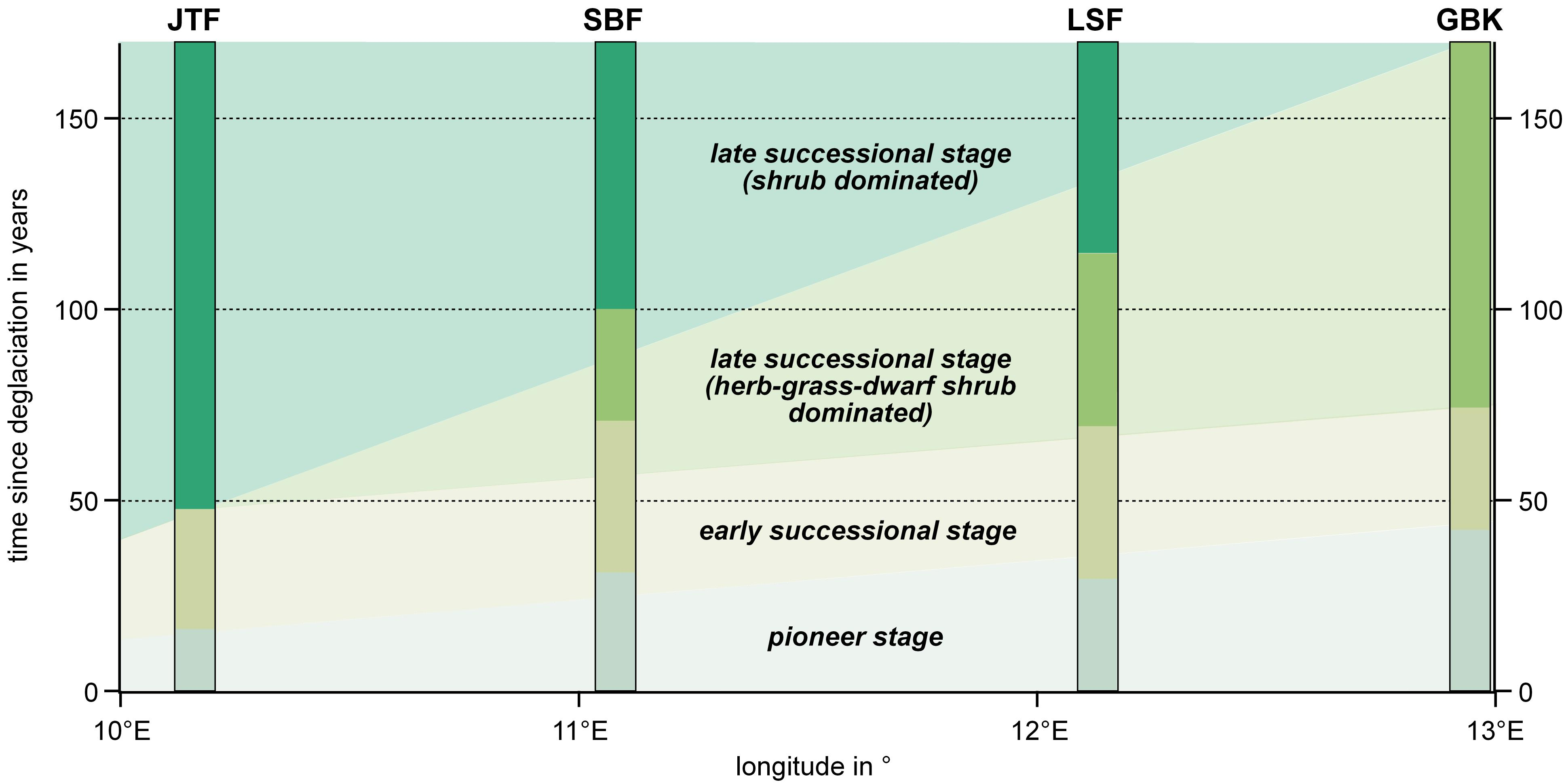
2.1. Study Areas

The four glacier forelands studied were Jamtalferner (JTF, Silvretta, Austria); Schwarzenbergferner (SBF, Stubai, Austria); Lenksteinferner (LSF, Rieserferner, Italy); and Goldbergkees (GBK, Hohe Tauern, Austria) (Table 1, Figure 1). With the exception of SBF, which is facing southwest, all other glacier forelands are located in a northerly direction. Substrate in the glacier forelands is generally coarse grained and blocky siliceous glacial debris without signs of soil development in recently deglaciated environments, while in areas deglaciated for a century or more, Skeletic/Lithic Leptosols are present. The climate within the Eastern Central Alps is humid year-round, locally with some subcontinental characteristics due to rain shadow effects caused by orographic rain at both the Northern and Southern Limestone Alps. Climate data for the actual glacier forelands were not available and existing interpolated climate surfaces are rather coarse ([27,28] with grid spacing of 5 km, and 1 km, respectively) to extract climatic gradients within the glacier forelands that are suitable for statistical correlations to vegetation data. Thus, only rough climatic estimates can be given for the glacier forelands as a whole. According to modeled data [27,28] and available meteorological stations in the surroundings of the study sites (Figure 1), precipitation in the glacier forelands studied can be estimated to be between 1300 and 1600 mm per year. The most humid study area is the GBK in the East, where rain shadow effects caused by the Northern and Southern Limestone Alps are less pronounced than further to the West (Table 1). The driest study sites are SBF and LSF on the Northern and Southern side of the Central Alpine chain, respectively, where rain shadow effects are most pronounced. A large amount of precipitation at high elevation falls as snow, remaining on the ground for about 6–9 months with an increasing snow cover duration from West to East [29]. Assuming a vertical temperature lapse rate of 0.6 K/100 m and station data of the vicinity, mean annual temperature within the glacier forelands can be assumed to be between 0 °C to −3.5 °C with positive means occurring only during a few weeks in summer.
Elevation of the glacier forelands as well as the relative position with regard to treeline differs (Figure 2). While at GBK, LIA terminal moraine and thus the oldest sample sites (at 2180 m a.s.l.) are located well above treeline (~2000 m a.s.l.) within the alpine belt, LIA terminal moraines of the remaining study sites are located close to the treeline ecotone, i.e., the transition zone between the forested subalpine and the treeless alpine belt (JTF and SBF ~2200 m a.s.l.; LSF ~2350 m a.s.l.). Recent glacier termini and thus the youngest sample sites are located within the upper alpine belt (JTF, SBF, GBK) or are surrounded by subnival scree slopes (SBF). Although own quantitative data are not available, vegetation in the surrounding of the four glacier forelands belongs (amongst others) to Caricetum curvulae RÜBEL 1911, Nardetum alpigenum BR.BL. 1949, Loiseleurio-Cetrarietum BR.BL. 1939 or Rhododendro ferruginei-Vaccinietum BR.BL. 1927 associations, scattered across the landscape. Figure 3 provides aspects of the four glacier forelands.
A regionalization of the climate within the European Alps carried out by Auer et al. [30] revealed four horizontal coarse resolution subregions of similar climatic features (Figure 1), delineated basically by the Central Alpine chain separating a temperate westerly climate in the North form a Mediterranean subtropical climate in the South, and a second boundary separating oceanic influences of the Atlantic in the West from continental characteristics of the Eurasian continent in the East. According to this regionalization, JTF and SBF belong to the Northwestern section characterized by a temperate westerly, oceanic climate, LSF to the oceanic Southwestern section on the Southern side of the Alps with slightly higher mean annual temperatures up to around 2200 m a.s.l. compared to sites in the North at the same elevation, and GBK to the Northeastern section with a continental temperate westerly climate (Figure 1). Actual precipitation is controlled by rain shadow effects, being responsible for the somewhat counterintuitive situation that the “oceanic” SBF and LSF receive less precipitation than the “continental” GBK.
Besides recent and sub-recent (i.e., post LIA) environmental conditions, history of flora is potentially an influencing factor for primary succession in glacier forelands of the Alps [25]. During repeated Pleistocene glaciations [31,32], most of the higher central parts of the Alps were covered by a massive ice sheet, either replacing plants to refugia in the periphery of the Alps (mainly in the South and Southwest, but also in the East of the Alpine bow where glaciation was more localized due to low absolute summit elevations), or restricting them to climatically favored locations within the Alps such as sunny slopes and nunataks protruding the ice [33,34,35,36,37]. Those refugia have been the source areas for the recolonization by plants in postglacial times (Figure 1) and are responsible for present-day patterns of species richness within the Alps, which is higher in the West than in the East [38]. Thus, different species pools in the surroundings of the four the glacier forelands might affect the respective primary succession [25].

2.2. Vegetation Data

The chronosequences studied extend from the recent glacier terminus down to the LIA terminal moraines. Glacier retreat since the LIA maximum extent was not consistent, rather there were some short phases of glacier stagnation or even advances during the last one and a half centuries (e.g., around 1890, 1920, and in the 1970s to 1980s), in many cases visible in the field by geomorphological structures. In combination with historical maps showing the glacier terminus, and glacier length change records, rather detailed mapped chronologies of the local glacier retreat since LIA are available for the four glacier forelands [12,24,41,42], allowing for a sufficiently accurate age determination of the sample sites.
Depending on local topography, vertical and horizontal extension between youngest and oldest samples (see Table 1), number and age of sample sites, as well as the spatial and temporal distance between them vary:
  • JTF: Total length 2.15 km; elevational difference 330 m; 9 different sample locations (A: 1 year.; B: 7 years.; C: 15 years.; D: 25 years.; E: 55 years.; F: 70 years.; G: 90 years.; H: 120 years.; I: 150 years).
  • SBF: Length 2.1 km; elevational difference 615 m; 10 different sample locations (A: 4 years.; B: 5 years.; C: 15 years.; D: 20 years.; E: 40 years.; F: 60 years.; G: 80 years.; H: 110 years.; I: 130 years.; J: 155 years.)
  • LSF: Length 1.25 km; elevational difference 260 m; 9 different sample locations (A: 2 years.; B: 4 years.; C: 20 years.; D: 35 years.; E: 55 years.; F: 75 years.; G: 90 years.; H: 120 years.; I: 155 years.)
  • GBK: Length 1.3 km; elevational difference 220 m; 8 different sample locations (A: 2 years.; B: 4 years.; C: 15 years.; D: 25–30 years.; E: 55 years.; F: 85 years.; G: 120 years.; H: 155 years.)
At each of the sample locations (A to K), vegetation sampling was conducted on three sample sites of 10 m2 (2 × 5 m) representing “mean” site conditions, i.e., wet hollows with above-average snow cover duration or dry, wind exposed knolls are disregarded. Sampling occurred square-meter-wise by visual estimation of the ground cover of each vascular plant species (taxonomy according to [43]), terricolous lichen species, and moss (sampled as undifferentiated species group) with the smallest unit being 0.01% ground cover (i.e., 1 cm × 1 cm on a 1 m2-subplot). Raw data were subsequently converted to mean ground cover values as well as total number of species, first per sample site (i.e., 10 m2), then for the sample location (i.e., 30 m2).
In addition to species data, life-forms as well as plant functional traits indicative of the ecological conditions the species experience at the sites where they occur were collected from published sources for all vascular plant species, to assess spatio-temporal variation within and between the four glacier forelands:
  • Life-form composition (according to [44]: therophytes (Th, annual herbaceous plants), geophytes (G, plants with tuberous subterranean organs), graminoid hemicryptophytes (H gram, perennial grasses), herbaceous hemicryptophytes (H herb, perennial herbaceous plants), chamaephytes (Ch, woody dwarfshrubs growing less than 0.5 m tall), nanophanerophytes (NaPh, shrubs growing 0.5–2.0 m tall), and macrophanerophytes (MacPh, trees reaching 20–50 m in adult stage), as well as moss and lichens. The life-form classification followed [43].
  • Ecological indicator values of vascular plants (according to [45]) were used for an ecological assessment of sample sites. Values vary between 1 and 5 and the following parameters were used: Soil moisture (dry = 1, wet = 5), light (shady = 1, full sun = 5), continentality (oceanic = 1, continental = 5), temperature (alpine/nival = 1, collinean = 5), pH (acidic = 1, basic = 5), soil aeration/texture (compacted = 1, loose, rocky/sandy = 5), soil humus content (humus-free = 1, peaty = 5), and soil nutrients content (oligotrophic = 1, eutrophic = 5).

2.3. Data Analysis

Data analyses employed uni- and multivariate statistical procedures. Vegetation development during succession is expressed by changes in species composition and quantifiable structural characteristics such as species numbers, ground cover (of singular taxa and total), and life-form composition. Changes in species richness and groundcover during succession is displayed by polynomial regressions; the composition of life-forms for each sample location by bar graphs indicating the relative contribution (i.e., ground cover) of a group to total ground cover. In addition, for each sample location, a ground cover weighted score S (according to [46,47]) was calculated for each plant functional trait according to the following equation:
S = ( t r a i t ( s p e c i e s i ) g r o u n d   c o v e r ( s p e c i e s i ) ) g r o u n d   c o v e r ( s p e c i e s i )
changes of this trait score during succession are displayed by polynomial regressions.
To define different successional stages without an a priori definition (e.g., a particular terrain age), floristic (dis)similarity of samples as well as structural features such as life-form composition and total ground cover have to be taken into account. As primary succession is generally a process of gradual changes in species composition and site conditions, which can be captured more realistically by ordination than by classification techniques, a principal component analysis (PCA) considering the mean ground cover values of each species per sample location (30 m2) was carried out. The graphic display of the PCA was by a two-dimensional scatterplot showing the location of samples within the multidimensional ordination space by symbols. The explanatory data available (i.e., species traits scores, life-form composition, elevation, and site age) did not influence the calculation of the ordination axes; rather, they only support the interpretation of vegetation patterns. Explanatory variables are shown as arrows, pointing from the origin of ordinates in the direction of samples with above average values of the particular variable, where the length of the arrows represent the relevance of the variable. The ordination analysis was performed with the software Canoco 4.5 [48].
To quantify floristic (dis)similarities between the four study areas, Sørensen similarity indices [49] were calculated for complete species inventories, as well as for different successional stages according to the following equation:
S I = 2 a ( 2 a + b + c )
where a is the number of species held in common by both data sets, while b and c are the number of species encountered in only one of the two data sets. In this calculation, shared species are given double weight, as the presence of a species is regarded to be more informative than its absence [50]. The values are between 0 and 1 representing total dissimilarity (i.e., no species in common) to 100% similarity, respectively.

3. Results

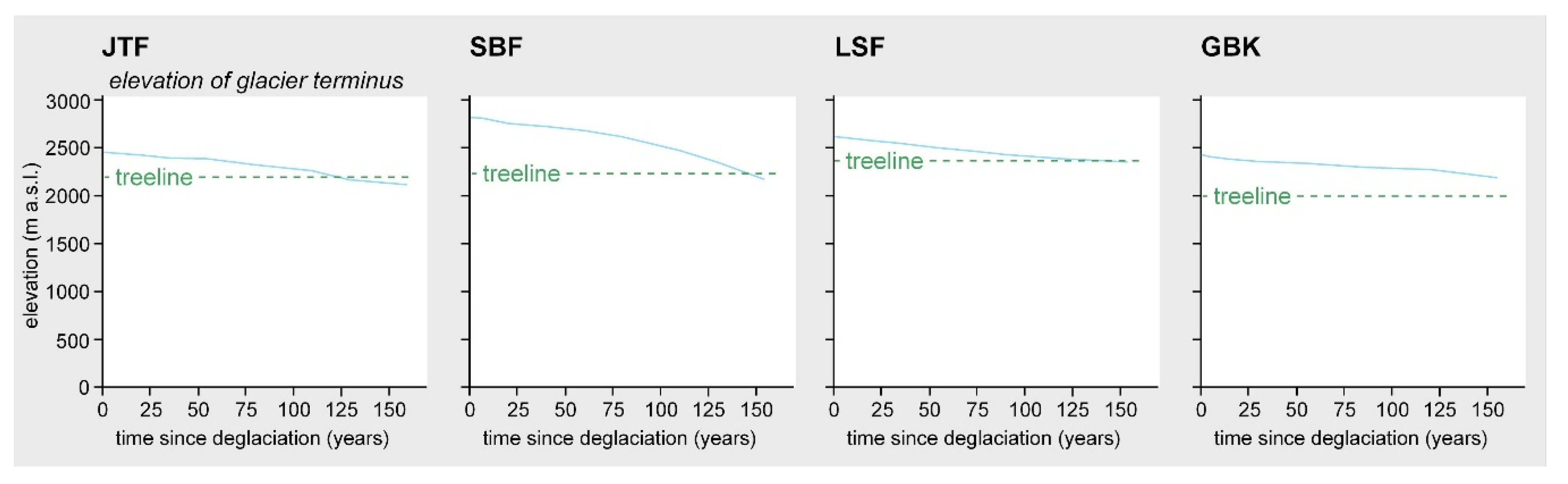
3.1. Floristic Aspects, Species Richness Patterns, and Ground Cover Development

Overall, 144 vascular plants, six terricolous lichens, and moss (as undifferentiated species group) were recorded in the four glacier forelands (Supplementary Table S1). Vascular plant species numbers within individual glacier forelands varied between 70 at GBK and 91 at SBF. Vascular plant species richness at LSF (76 species) and JTF (82 species) were intermediate. Terricolous lichen species recorded were one at GBK, two at LSF, four at JTF, and five at SBF. Moss was present at all glacier forelands. Thirty-one species (20.4%) were present in all four glacier forelands, 34 (22.4%) in three, 22 species (14.5%) in two, and 65 species (42.8%) were single occurrences. The most species rich families were Asteraceae (22 taxa), Poaceae (15 taxa), Caryophyllaceae (10 taxa), Ericaceae (9 taxa), Salicaceae (9 taxa), and Saxifragaceae (8 taxa). Most of the genera were represented by one, two, or three species at most, except for Salix (nine taxa) and Saxifraga (eight taxa) (see Supplementary Table S1). Sørensen similarity indices [49] calculated for comparisons of total species inventories encountered within the four glacier forelands (Table 2) proved a rather high number of matching species in neighboring glacier forelands (up to 69% similarity; see JTF–SBF, SBF–LSF, LSF–GBK in Table 2), decreasing to below 50% for the two most distant areas JTF and GBK.
During succession, species numbers and ground cover values increased with time (Figure 4). Depending on site conditions and the species present in the surroundings, species numbers of recently deglaciated sites varied between (close to) zero (GBK and LSF) and more than 20 (JTF and SBF) per 30 m2 samples. With site age, species numbers increased to 40–50 in all glacier forelands. The sharp decrease in species richness on the oldest site of SBF is most likely a result of a specific microclimatic situation caused by cold air trapping in the upper Sulz valley [24]. Beyond that, a rather negative logarithmic trend line (i.e., accelerated at the beginning, later slowing down and stabilizing) indicate some saturation in species numbers during succession (Figure 4a). In contrast, trendlines of ground cover values, in most cases, behaved more positively logarithmic, i.e., development of ground cover was delayed during the first decades of succession and sharply increased on older sites to around 80% in the West (JTF and SBF) and around 60% in the East (LSF and GBK) (Figure 4b). A slightly faster increase in ground cover could be observed at JTF.

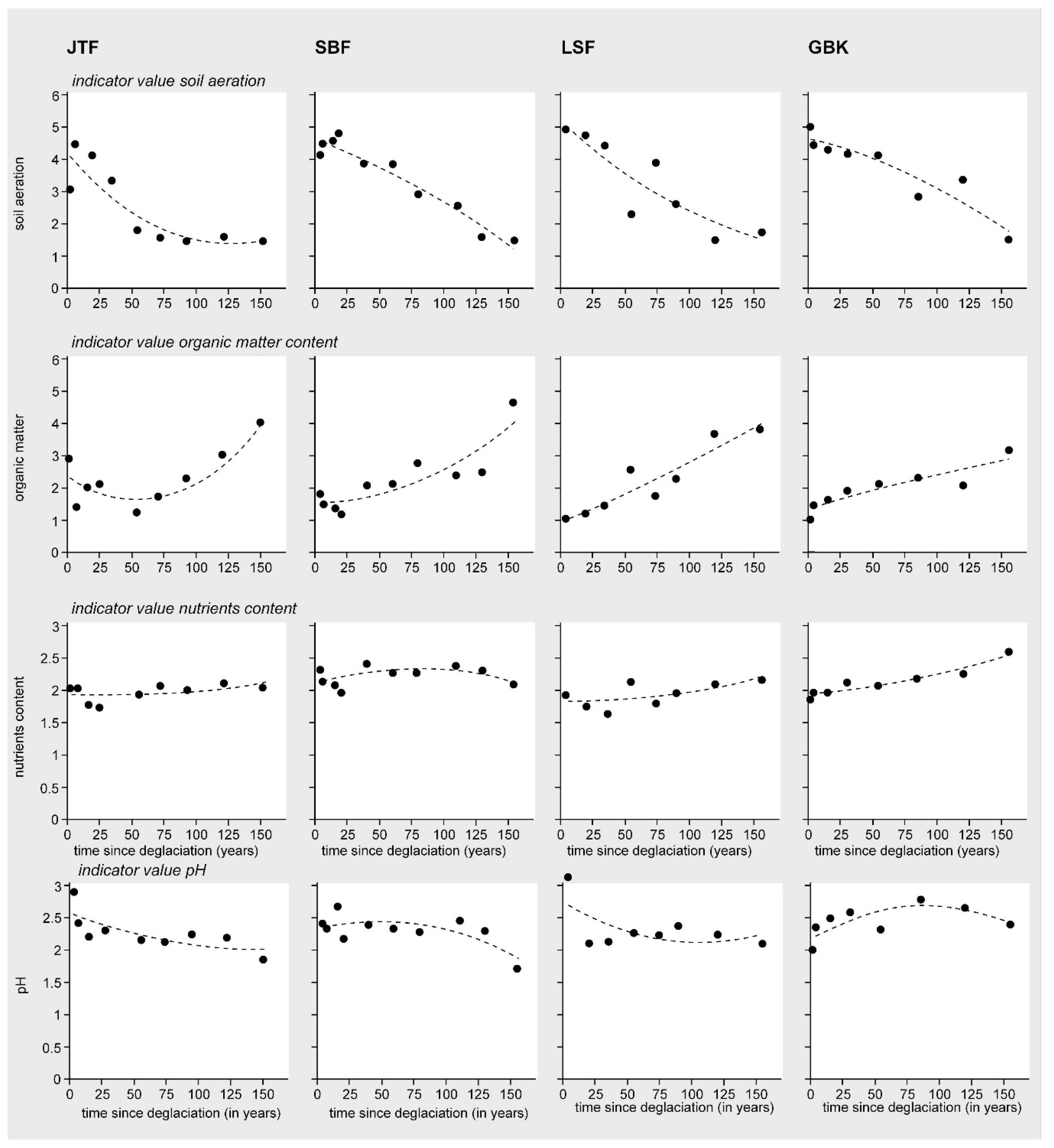
3.2. Patterns in Vegetation Structure, Life-Form Composition, and Ecological Plant Traits

The bar graphs in Figure 4c show life-form spectra of the sample locations. Vegetation development during the first couple of decades after deglaciation was dominated by mosses, dwarfshrubs (i.e., chameaphytes Ch), herbs (primarily herbaceous hemicryptophtes, Hherb), and grasses (graminoid hemicryptophtes, Hgram) in all four glacier forelands. While these life-forms were present throughout succession in variable abundances in all sampled chronosequences, geophytes and therophytes were very rare. Terricolous lichens appeared primarily after about half a century after deglaciation and rarely contributed much to total ground cover. One notable exception was the high lichen cover on the oldest sites at SBF, most likely favored by the cold air settling in the upper Sulz Valley, already highlighted above as being responsible for decreasing species numbers there [24]. Treelets of subalpine conifer species (Picea abies, Larix decidua) appeared only after more than one century since deglaciation.
The contribution of shrubs (nanophanerophytes, NaPh) to total ground cover showed a specific pattern. While at JTF in the West first shrubs already appeared on sites deglaciated for only 25 years and were the dominating life-form afterwards here, at GBK in the East they were underrepresented, even on the oldest sites. In the two study areas in between (SBF and LSF), shrubs appeared a century or more after deglaciation, replacing a grass–herb–dwarfshrub-dominated vegetation type present up to this point.
The ecological traits indicate the environmental preferences of the species concerning climate and soil conditions. Figure 5 shows that climatological traits in all glacier forelands exhibited similar trends during succession. Cover-weighted scores for temperature slightly increased with time, with cryophilous species (amongst others Leucanthemopsis alpina or Poa laxa) being more abundant at the youngest (i.e., highest) sites and thermophilous species (amongst others Leontodon hispidus or Anthyllis vulneraria ssp. alpicola) at the oldest (i.e., lowest) sites (see also correlation between trait “temperature” and “time since deglaciation” in Table S2). Due to high amounts of precipitation and long-lasting snow cover, species preferring high soil moisture prevailed throughout succession, thus scores for soil moisture changed only marginally along the chronosequences. Scores for light decreased from youngest to oldest sites as increasing ground cover during succession and lower elevation favored the occurrence of more shade-tolerant species of dense (sub)alpine communities (e.g., Picea abies, Vaccinium myrtillus). The scores for continentality have a somewhat broader scattering and obvious trends related to site age cannot be identified.
As with climatological traits, also concerning the soil conditions, the four glacier forelands exhibited similar trends, shown by the change of the cover-weighted edaphic traits scores with time since deglaciation (see Figure 6). Scores for soil aeration indicate well aerated, loose, rocky, or sandy soils left by the receding glaciers in the recently deglaciated forelands and more compacted soils on older sites. Scores for soil humus content rose considerably with increasing ground cover and species numbers, which are responsible for a successively higher amount of organic matter. A similar pattern (less pronounced, though) could be observed for the soil nutrient content. Scores for pH indicate intermediate conditions, with a slight shifting to more acidic conditions towards the older stages, probably due to an increasing abundance of ericaceous (dwarf-)shrubs, whose litter supports soil acidification.

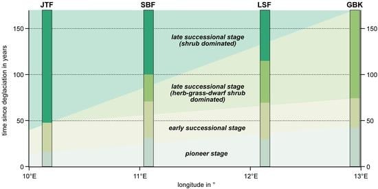
3.3. Successional Stages and Trajectories

To define successional stages based on gradual changes in species composition as well as structural measures such as life-form composition or species traits scores a PCA (Figure 7) was calculated, displaying the floristic similarity of samples (the closer the distance between sample symbols, the more similar). Axis 1 and 2 together explain 47.2% of the variance in the species data. Several site factors are highly correlated to axis 1, amongst those with a correlation coefficient r > 0.7 are total ground cover (r = 0.939), NaPh cover (r = 0.921), time since deglaciation (r = 0.855), moss cover (r 0.814), vascular plant species numbers (r = 0.759), temperature (r = 0.729), and soil aeration (r = −0.729). The site factor highest correlated to axis 2 is MacPh cover with r = 0.550. Considering similarity in species composition of the samples in conjunction with the structural patterns outlined above (and indicated by arrows in the ordination diagram), the PCA analysis allows to specify successional stages and trajectories.
The distinct clumping in the upper left quadrant of the PCA plot in Figure 7 includes samples deglaciated only recently in all four glacier forelands (JTF A-B; SBF A-D; LSF B-C; GBK A-D), and represents a pioneer stage of plant colonization in the glacier forelands. The clumping proves a high floristic similarity of sites deglaciated for 30 years at most. Besides the grass Poa laxa, several herbs (Hherb) such as Geum reptans, Oxyria digyna, Leucanthemopsis alpina, Veronica alpina, Cardamine resedifolia, Sagina saginoides and dwarfshrubs (Ch) such as Saxifraga bryoides, Cerastium uniflorum, Silene acaulis ssp. exscapa, Salix retusa, Sedum alpestre, Arabis alpina ssp. alpina had a broad geographical distribution and were present in all four glacier forelands during the pioneer stage (see Tables S1 and S3). Also, mosses were present; terricolous lichens, however, have not yet appeared. Ground cover values of the pioneer stage ranged between close to zero and slightly above 5%. Total number of vascular plant species occurring at this stage in the four glacier forelands jointly were 53, of which 13 species (24,5%) occured in all four glacier forelands, 5 species (9,4%) in three, 9 species (17%) in two, and 26 species (49, 1%) in just one. Sørensen similarity indices calculated separately for the pioneer stage of the four glacier forelands (Table 2) mirrored the results obtained for the entire species inventories, with high floristic similarity between neighboring glacier forelands (up to 70% similarity at JTF–SBF) and decreasing to only 52% for the two most distant areas JTF and GBK.
After about 20 to 30 years since deglaciation, an early successional stage can be distinguished, which lasted for the next two to three decades. Most of the pioneer species were still present, joined by a couple of additional species, among them the terricolous lichen Stereocaulon alpinum. With 64 species present in the four glacier forelands, the total species number of this stage, however, was not much higher compared to the pioneer stage. Ground cover values reached around 10% (lowest at LSF D 8.03%; highest at JTF D 13.35%), locally with a high contribution of mosses. According to the PCA in Figure 7, a high similarity between samples of this successional stage (JTF C-D; SBF E-F; LSF D-E; GBK E) still existed, but some separation also emerged. While in the pioneer stage, a quarter of the vascular plant species present occurred in all four glacier forelands; in the early successional stage, this value decreases to 17%. In contrast species present in just one of the glacier forelands rises from 48% to 56%, respectively. Consequently, Sørensen similarity indices for the early successional stage drop with respect to the pioneer stage (Table 2).
A striking divergence of successional trajectories appears in Figure 7 for the late successional stage encompassing the sites JTF E-I, SBF G-J, LSF F-I, and GBK F-H. Within this stage, two different phases can be distinguished, one that was characterized by a dominance of grasses, herbs, and dwarfshrubs, and one that was dominated by shrubs (Figure 7, see also Figure 4). While the former is somewhat transitional between the early successional stage and the late successional shrub phase at SBF and LSF, this phase is entirely missing at the westernmost JTF and, in contrast, represents the whole late successional stage in the easternmost GBK. Thus, a gradual shift from a shrub-dominated late successional stage in the West to an herb, grass, and dwarfshrub dominated late successional stage in the East (in particular the carpet willows Salix herbacea and S. retusa reach high groundcover at LSF (G-I) and GBK (F-H), see Table S1) can be observed. Ground cover values of the two different phases were between 20% and over 60% for the herb, grass, and dwarfshrub phase and between 40% and more than 80% for the shrub phase. The shrub phase at JTF, SBF, and LSF was characterized by a high groundcover of Rhododendron ferrugineum and various willow species (Salix div. spec.). In addition, about 120–150 years after deglaciation first conifer taxa such as Juniperus communis ssp. nana, Larix decidua or Picea abies appear. With 145 species recorded for the late successional stage in the four glacier forelands, total species number was much higher than in the pioneer and early successional stages. In total, 27 species (19%) were held in common in all four glacier forelands while almost half of the species (68 species, 47%) were present in just one (see also Table S1). Sørensen similarity indices for the late successional stage of the four glacier forelands slightly rose (for neighboring study areas) or fell (for distant study areas) compared to the early successional stage, with lowest floristic similarity (46%) between the shrub-dominated late successional stage at JTF and the herb, grass, and dwarfshrub-dominated late successional stage at GBK (Table 2).

4. Discussion

Primary succession in glacier forelands usually begins with simple aggregations of plants with few individuals and low ground cover. Later on, species assemblage becomes successively more complex, documented in changing figures of species numbers, of ground cover (of singular taxa and total), as well as in shifts in structural measures. Species numbers and ground cover values in the four glacier forelands studied generally increase with time since deglaciation, an unsurprising fact, known from many glacier forelands of the Alps (e.g., [12,16,17,18,20,21,22,23,25,26,51]) and beyond (e.g., [52,53,54,55]). A general decrease in species numbers due to late-successional species outcompeting earlier arrivals, which is reported from glacier forelands of the Western Alps [56,57], could not be observed. The sharp decrease in species numbers on the oldest sites at SBF is most likely favored by cold air settling in the upper Sulz Valley [24], which might also be responsible the high lichen cover there. An analogous interrelation between coldness and lichen abundance is reported from glacier forelands of the highly continental Central Altai [52].
Colonization of the bare ground starts immediately after deglaciation (see [21,58]) and within a couple of years around 20 different species are recorded in the four glacier forelands under consideration. Colonization during the pioneer stage is spearheaded by wind-dispersed species, carried into the glacier foreland by local wind systems from the surroundings [59,60]. Successful establishment of diaspores reaching the foreland primarily depends on moisture and nutrients supply. Larger rocks facilitate seedling establishment by offering safe sites with micro-climatically more favorable conditions [22] (pronounced warming, longer vegetation period, etc.). In addition, mutualistic effects between established individuals and newcomers seem to be important, while competition does not play a major role at that point of time [22,26]. Substrate in the recently deglaciated glacier forelands is blocky siliceous glacial debris without signs of initial soil development. The coarse substrate is prone to desiccation, but long-lasting snow cover, a slow, steady snow melt, and high summer precipitation (see climate charts in Figure 1) obviously prevents a substantial dieback of seedlings, a fact proven by complementary permanent plot studies at GBK and LSF [26,58]. Mineral nutrients are supplied by sediments, which are carried to the glacier forelands by wind or are released by the melting glaciers. In addition, dry and wet atmospheric N-deposition cause a “natural manuring”, offsetting a lack of organic matter [61,62,63,64]. Cyanobacteria and lichens with cyanobacteria component are major nitrogen producers on barren glacier forelands by fixation of the atmospheric nitrogen [65,66]. Recent studies [64,67,68] showed that beside nitrogen a lack of phosphorous can also be limiting factor for primary succession in glacier forelands. In recently deglaciated terrain, however, bioavailable phosphorus is commonly provided by weathering of the bedrock [67].
During succession, ground cover and species numbers increase, the latter showing some saturation caused by inter- and intraspecific competition as well as a lack of available space for colonization due to increasing ground cover (Figure 4, [7]). In the late successional stage, species number is more than doubled compared to the pioneer and early successional stage, not only because of the two different phases, but also because several early colonizers exhibit a high persistence. Once established, they occur from pioneer and/or early successional stage throughout into the late successional stage (e.g., Saxifraga bryoides, Poa laxa, Silene acaulis ssp. exscapa, Geum reptans, Oxyria digyna, Sagina saginoides, Veronica alpina, Sedum alpestre, Leucanthemopsis alpina, Salix herbacea, see Tables S1 and S3), where they are joined by species from lower elevations requiring more advanced soil conditions as well as warmer temperatures. Highly persistent plants are those with the ability for clonal growth [21,59,69]. However, increasing ground cover and species richness intensify interspecific competition and eliminate some pioneers and early colonizers weak in competition (amongst others Oxyria digyna, Saxifraga exarata ssp. exarata, Arabis alpina, Epilobium anagallidifolium, see also Tables S1 and S3).
A certain degree of similarity between the four glacier forelands studied (see Table 2) hints at a superordinate species pool with taxa characteristic for the siliceous Eastern Alps. However, local site conditions (elevation, exposure, topography, substrate, etc.) and the “floristic character of the surroundings”, highlighted by Raimund von Klebelsberg [15] already at the beginning of the 20th century as important driver for species composition in glacier foreland succession, are responsible for some divergences. Floristic dissimilarities increase with distance between study sites and with time since deglaciation. Differences in species composition are most distinct between JTF and GBK for both complete species inventories as well as individual successional stages. A floristic analysis of the Alps by Aeschimann et al. [38] has shown that species richness is higher in the Western Alps than in the Eastern Alps due to Holocene remigration patterns after the last Pleistocene glaciation. A similar pattern was observed for glacier foreland vegetation with slightly higher species numbers in the Western Alps compared to the Eastern Alps [25]. Thus, species composition at the westernmost JTF might be affected by a potentially larger species pool. This, however, is hypothetical and has to be tested further by chorological analyses, but the fact that the number of single occurrences (i.e., species present in only one glacier foreland) is highest at JTF (26) and is successively decreasing to the East (SBF 19; LSF 9; GBK 11) underpins this assumption. Furthermore, differences in species composition between the glacier forelands studied are lower at the pioneer stage and become more pronounced during early and late successional stages (Table 2), indicating that a few widespread specialists regulate plant colonization in the recently deglaciated glacier forelands of the Eastern Alps irrespective of elevation and exposure [25]. The floristic inventory of later stages, in contrast, depends largely on the location of the glacier forelands. In particular, the relative position of the glacier foreland to treeline seems to be an important driving factor [25]. Species composition and richness are not so much triggered by elevation per se, rather by the vegetation belt in which it is located. For instance, sample sites at GBK being deglaciated for one and a half century are located within the alpine belt well above treeline (see Figure 2 and Figure 3) and exhibit less species compared to the same-aged sample sites on LSF which are—despite higher absolute elevation—located close to the treeline ecotone (see Figure 2 and Figure 3), allowing for a conglomerate of subnival, alpine, and subalpine elements. Also, the species rich late successional stages at JTF and SBF are located within the treeline ecotone. These richness patterns are in line with findings of a larger scale study comparing glacier forelands of the Western and Eastern Alps [25].
A designation of discrete phytosociological plant communities in glacier forelands is generally difficult due to the highly dynamic environment, a high randomness of colonizing species, and a broad range of gradually changing site conditions [7,19,70]. However, the pioneer stage of primary succession of the Eastern Alpine glacier forelands under consideration with many species in common, most conveniently can be assigned to Sieversio-Oxyretum digynae Friedel 1956 em. Englisch et al. 1993 [71]. The slightly more diverse early successional stage is kind of transitional to either a herb–grass and dwarfshrub-dominated late successional stage, which might develop towards Saxifrago bryoides-Poetum alpinae and/or Agrostio rupestris-Trifolietum pallescensis communities [19], or a shrub-dominated late successional stage belonging to acidophilous heath communities, which can be assigned to Rhododendro-Vaccinetum [72].
Concerning structural measures, the four glacier forelands exhibit a couple of corresponding characteristics. The trendlines of ecological trait scores calculated for each sample location predominantly match (see Figure 5 and Figure 6). Thus, vegetation development during primary succession in Eastern Alpine glacier forelands shows some common supra-regional patterns, independently of species composition (i.e., different species indicate similar ecological conditions). Life-form composition (Figure 4c), however, in particular during the late successional stage, confirms diverging trajectories during succession, emerging by species composition (Figure 7). While the pioneer stage in all four glacier forelands are structurally highly similar, diverging trajectories emerge from the early successional stage onward and are particularly obvious in the late successional stage. At JTF, during the early successional stage, shrubs are already present (Figure 4). In contrast, at GBK, shrubs are underrepresented even on sites deglaciated for one and a half century. Here, the late successional stage is still dominated by herbs, grasses, and dwarfshrubs. This effect is not related to the elevation of the glacier forelands, as the lowest (= oldest) sample location at GBK is lower than same-aged sites at LSF. Again, the elevation of treeline seems to be the major point.
Figure 8 indicates a gradual change from West to East in both the timing of the onset of early and late successional stages as well as the type of the respective vegetation. Early and late successional stages as well as shrub appearance are achieved after a shorter period of time in the glacier foreland of JTF in the West compared to the study sites further to the East, and the late successional phase is characterized by shrubs throughout at JTF. At the easternmost GBK, a late successional shrub phase is entirely missing, as vegetation development after one and a half century remains in a grass–herb–dwarfshrub-dominated late successional phase one and a half century after deglaciation. At SBF and LSF, geographically located in between, the late successional stage starts with a grass–herb–dwarfshrub phase, before about a century or more after deglaciation a shrub-dominated late successional phase emerges (Figure 8).
A low abundance of shrubs in the late successional stage is reported from other Eastern Alpine glacier forelands, e.g., from the foreland of Obersulzbachkees, which is like GBK located in the Hohe Tauern [51]. The authors of this study assume grazing to be responsible for low shrub cover there. However, in the study at hand, grazing within the LIA moraines by cattle and/or sheep takes place only at JTF and SBF, sites with a high shrub abundance, while in the ungrazed glacier forelands of LSF and GBK, shrubs occur late or are almost entirely missing (Figure 8). Therefore, grazing seems not to be responsible for differences in shrub occurrence within the glacier forelands studied.
The results presented here to some extent confirm observations made by comparing glacier forelands of the Eastern and Western Alps [25]. This study found regional differences in vegetation structure with a “late successional shrubland” in Western Alps and a “late successional grassland” in the Eastern Alps, which were explained by different species pools and different elevations of the treeline between the West (higher) and East (lower, see also [73]). The West to East shift in timing of the onset as well as vegetation type of successional stages/phases detected by the study at hand is in line those findings and supports the assumption that location of the glacier foreland in relation to the treeline is the important driver of succession: LIA terminal moraines at JTF, SBF and LSF are located within the treeline ecotone, while at GBK, treeline is significantly lower (Figure 2), due to a colder general climate in the East compared to the West [4], and probably intensified by an anthropogenic downward displacement of the treeline in the past for expanding pasture area as well as for satisfying wood demand in the context of mining history [74].

5. Conclusions

Studies on plant succession are highly relevant tasks for the understanding of the colonization processes, which in turn provide insights for rehabilitation measures in disturbed ecosystems [6]. In this regard, chronosequences, if interpreted cautiously, allow for the recognition of general trends and trajectories of vegetation dynamics on time scales much longer than a researcher’s lifespan [13]. The study at hand supports the assumption that different successional trajectories in glacier forelands exist due to combined effects of local site conditions (moist vs. dry sites, sunny vs. shady sites, coarse-grained vs. fine-grained substrates, etc.), and large-scale factors such as different species pools, elevation of the glacier foreland, and location relative to treeline [20,23,25,53]. Trajectories might be converging or diverging depending on locality and/or successional stage [53]. In this study, the pioneer stages of the four glacier forelands are rather similar both floristically and structurally, irrespective of elevation, exposure, and geographical location. From the early successional stage onwards, however, differences increase, leading to different phases in the late successional stage. As development towards shrub-dominated vegetation is obviously faster in the West, it can be expected that the shrub phase will replace the herb–grass–dwarfshrub phase currently still present in the glacier forelands to the East in the decades to come, a process probably enhanced by ongoing climate warming.

Supplementary Materials

The following are available online at https://www.mdpi.com/1424-2818/12/5/191/s1, Table S1: Species list of the four glacier forelands studied. Table S2: Correlation matrix of explanatory variables used in the PCA analysis in Figure 7; high correlations (>±0.5) are printed bold. Table S3: Seriation table of widespread vascular plant species present in all four glacier forelands.

Funding

This research received no external funding

Acknowledgments

Fieldwork at SBF was supported by Friederike Grüninger. The author is grateful for valiable comments of three anonymous reviewers on an earlier draft of the manuscript, which greatly improved the outcome.

Conflicts of Interest

The author declares no conflict of interest.

References

  1. Warming, E. Plantesamfund: Grundtræk af den økologiske Plantegeografi; Philipsens Kjøbenhavn: Kopenhagen, Denmark, 1895; p. 335. [Google Scholar]
  2. Cowles, H.C. The Ecological Relations of the Vegetation on the Sand Dunes of Lake Michigan; The University of Chicago Press: Chicago, IL, USA, 1899. [Google Scholar]
  3. Clements, F.E. Plant Succession: An Analysis of the Development of Vegetation; Carnegie Institution of Washington: Washington, DC, USA, 1916; p. 512. [Google Scholar]
  4. Ellenberg, H. Vegetation Ecology of Central Europe; Cambridge University Press: Cambridge, UK, 1988; p. 731. [Google Scholar]
  5. Matthews, J.A. The Ecology of Recently-Deglaciated Terrain. A Geoecological Approach to Glacier Forelands and Primary Succession; Cambridge University Press: Cambridge, UK, 1992; p. 386. [Google Scholar]
  6. Walker, L.R.; Del Moral, R. Primary Succession and Ecosystem Rehabilitation; Cambridge University Press: Cambridge, UK, 2003; p. 442. [Google Scholar]
  7. Erschbamer, B.; Caccianiga, M.S. Glacier forelands: Lessons of plant population and community development. Prog. Bot. 2017, 78, 259–284. [Google Scholar]
  8. Paul, F.; Kääb, A.; Maisch, M.; Kellenberger, T.; Haeberli, W. Rapid disintegration of Alpine glaciers observed with satellite data. Geophys. Res. Lett. 2004, 31, L21402. [Google Scholar] [CrossRef] [Green Version]
  9. Zemp, M.; Haeberli, W.; Hoelzle, M.; Paul, F. Alpine glaciers to disappear within decades? Geophys. Res. Lett. 2006, 33, L13504. [Google Scholar] [CrossRef] [Green Version]
  10. Fischer, A.B.; Seiser, B.; Stocker Waldhuber, M.; Mitterer, C.; Abermann, J. Tracing glacier changes in Austria from the Little Ice Age to the present using a lidar-based high-resolution glacier inventory in Austria. Cryosphere 2015, 9, 753–766. [Google Scholar] [CrossRef] [Green Version]
  11. Pickett, S.T.A. Space-for-time substitution as an alternative to long-term studies. In Long-Term Studies in Ecology: Approaches and Alternatives; Likens, G.E., Ed.; Springer: New York, NY, USA, 1989; pp. 110–135. [Google Scholar]
  12. Fischer, A.; Fickert, T.; Schwaizer, G.; Patzelt, G.; Groß, G. Vegetation dynamics in Alpine glacier forelands tackled from space. Nature Sci. Rep. 2019, 9, 13918. [Google Scholar] [CrossRef] [Green Version]
  13. Walker, L.R.; Wardle, D.A.; Bardgett, R.D.; Clarkson, B.D. The use of chronosequences in studies of ecological succession and soil development. J. Ecol. 2010, 98, 725–736. [Google Scholar] [CrossRef]
  14. Coaz, J. Erste Ansiedlung Phanerogamer Pflanzen auf von Gletschern Verlassenem Boden; Mitteilungen der Naturforschenden Gesellschaft Bern: Bern, Switzerland, 1887; pp. 3–12. [Google Scholar]
  15. Von Klebelsberg, R. Das Vordringen der Hochgebirgsvegetation in den Tiroler Alpen. Eine alpin-pflanzengeographische Studie. Osterr. botan. Zeitschrift 1913, 63, 177–186. [Google Scholar] [CrossRef]
  16. Lüdi, W. Beobachtungen über die Besiedlung von Gletschervorfeldern in den Schweizeralpen. Flora oder Allg. Bot. Ztg. 1958, 146, 386–407. [Google Scholar] [CrossRef]
  17. Pirola, A.; Credaro, V. Changes in the vegetation of a recent glacial moraine in the Bernina group. Annali di Botanica LI 1993, 51, 145–153. [Google Scholar]
  18. Andreis, C.; Caccianiga, M.; Cerabolini, B. Vegetation and environmental factors during primary succession on glacier forelands. Plant Biosyst. 2001, 135, 295–310. [Google Scholar] [CrossRef]
  19. Caccianiga, M.; Andreis, C. Pioneer herbaceous vegetation on glacier forelands in the Italian Alps. Phytocoenologia 2004, 34, 55–89. [Google Scholar] [CrossRef]
  20. Raffl, C.; Mallaun, M.; Mayer, R.; Erschbamer, B. Vegetation succession pattern and diversity changes in a Glacier Valley, Central Alps, Austria. Arct. Antarct. Alp. Res. 2006, 38, 421–428. [Google Scholar] [CrossRef] [Green Version]
  21. Cannone, N.; Diolaiuti, G.; Guglielmin, M.; Smiraglia, C. Accelerating climate change impacts on alpine glacier forefield ecosystems in the European Alps. Ecol. Appl. 2008, 18, 637–648. [Google Scholar] [CrossRef] [PubMed] [Green Version]
  22. Erschbamer, B.; Niederfriniger Schlag, R.; Winkler, E. Colonization processes on a central alpine glacier foreland. J. Veg. Sci. 2008, 19, 855–862. [Google Scholar] [CrossRef]
  23. Burga, C.A.; Krüsi, B.; Egli, M.; Wernli, M.; Elsener, S.; Ziefle, M.; Fischer, T.; Mavrisa, M. Plant succession and soil development on the foreland of the Morteratsch glacier (Pontresina, Switzerland): Straight forward or chaotic? Flora 2010, 205, 561–576. [Google Scholar] [CrossRef] [Green Version]
  24. Loher, T.; Sextl, K.; Grüninger, F.; Fickert, T. Gletscherrückgang und Vegetationsentwicklung im Vorfeld des Schwarzenbergferners (Stubaier Alpen, Tirol) seit dem Ende der Kleinen Eiszeit. Jahrb. des Ver. zum Schutz der Bergwelt 2013, 78, 139–164. [Google Scholar]
  25. Schumann, K.; Gewolf, S.; Tackenberg, O. Factors affecting primary succession of glacier foreland vegetation in the European Alps. Alp. Bot. 2016, 126, 105–117. [Google Scholar] [CrossRef]
  26. Fickert, T. Glacier forelands—Unique field laboratories for the study of primary succession of plants. In Glaciers Evolution in a Changing World; Godone, D., Ed.; InTech Open: London, UK, 2017; pp. 125–146. [Google Scholar] [CrossRef] [Green Version]
  27. Isotta, F.A.; Frei, C.; Weilguni, V.; Perčec Tadić, M.; Lassègues, P.; Rudolf, B.; Pavan, V.; Caccia-mani, C.; Antolini, G.; Ratto, S.M. The climate of daily precipitation in the Alps: Development and analysis of a high-resolution grid dataset from pan-Alpine rain-gauge data. Int. J. Climatol. 2014, 34, 1657–1675. [Google Scholar] [CrossRef]
  28. Hijmans, R.; Cameron, S.; Parra, J.; Jones, P.; Jarvis, A. Very high resolution interpolated climate surfaces of global land areas. Int. J. Climatol. 2005, 25, 1965–1978. [Google Scholar] [CrossRef]
  29. Abermann, J.; Kuhn, M.; Fischer, A. Climatic controls of glacier distribution and glacier changes in Austria. Ann. Glaciol. 2011, 52, 83–90. [Google Scholar] [CrossRef] [Green Version]
  30. Auer, I.; Böhm, R.; Jurkovic, A.; Lipa, W.; Orlik, A.; Potzmann, R.; Schöner, W.; Ungersböck, M.; Matulla, C.; Briffa, K. HISTALP—Historical instrumental climatological surface time series of the greater Alpine region 1760-2003. Int. J. Climatol. 2007, 27, 17–46. [Google Scholar] [CrossRef]
  31. Ehlers, J.; Gibbard, P.L. Quaternary glaciations—extent and chronology: Part I: Europe. In Developments in Quaternary Sciences; Elsevier: Amsterdam, The Netherlands, 2004; p. 488. [Google Scholar]
  32. Ehlers, J.; Gibbard, P.L.; Hughes, P.D. Quaternary glaciations—extent and chronology: A closer look. In Developments in Quaternary Sciences; Elsevier: Amsterdam, The Netherlands, 2011; p. 1126. [Google Scholar]
  33. Engler, A. Pflanzen-Formationen und die Pflanzengeographische Gliederung der Alpenkette Erläutert an der Alpenanlage des Neuen Königlichen Botanischen Gartens zu Dahlem-Steglitz bei Berlin, mit 2 Orientierungskarten; Wilhelm Engelmann: Leipzig, Germany, 1903; p. 96. [Google Scholar]
  34. Merxmüller, H. Untersuchungen zur Sippengliederung und Arealbildungen in den Alpen. In Jahrbuch des Vereins zum Schutz der Alpenpflanzen und -tiere; Verein zum Schutz der Alpenpflanzen und -tiere: Munich, Germany, 1952; Volume 17, pp. 96–133. [Google Scholar]
  35. Stehlik, I. Nunataks and peripheral refugia for alpine plants during Quaternary glaciation in the middle part of the Alps. Bot. Helv. 2000, 110, 25–30. [Google Scholar]
  36. Parisod, C. Postglacial recolonisation of plants in the western Alps of Switzerland. Bot. Helv. 2008, 118, 1–12. [Google Scholar] [CrossRef]
  37. Schneeweiss, G.M.; Schönswetter, P. A re-appraisal of nunatak survival in arctic-alpine phylogeography. Mol. Ecol. 2011, 20, 190–192. [Google Scholar] [CrossRef] [PubMed]
  38. Aeschimann, D.; Rasolofo, N.; Theurillat, J.-P. Analyse de la Flore des Alpes. 1: Historique et Biodiversité. Candollea 2011, 66, 27–55. [Google Scholar] [CrossRef]
  39. ZAMG Climate Data for Austria 1971–2000. Available online: https://www.zamg.ac.at/fix/klima/oe71-00/klima2000/klimadaten_oesterreich_1971_frame1.htm (accessed on 6 April 2020).
  40. Wikipedia Alpenrelief 01. Available online: https://de.wikipedia.org/wiki/Alpen#/media/File:Alpenrelief_01.jpg (accessed on 5 April 2020).
  41. Böhm, R.; Schöner, W.; Auer, I.; Hynek, B.; Kroisleitner, C.; Weyss, G. Gletscher im Klimawandel: Vom Eis der Polargebiete zum Goldbergkees in den Hohen Tauern; Zentralanstalt für Meteorologie und Geodynamik: Wien, Austria, 2007; p. 111. [Google Scholar]
  42. Damm, B. Gletscher-, Landschafts- und Klimaentwicklung in der Rieserfernergruppe (Tirol) seit dem Spätglazial. Göttinger Geogr. Abh. 1996, 104, 186. [Google Scholar]
  43. Fischer, M.A.; Adler, W.; Oswald, K. Exkursionsflora für Österreich, Liechtenstein und Südtirol; Land Oberösterreich, OÖ Landesmuseum: Linz, Austria, 2005; p. 1380. [Google Scholar]
  44. Raunkiaer, C. The Life Forms of Plants and Statistical Plant Geography; Oxford University Press: Oxford, UK, 1934; p. 632. [Google Scholar]
  45. Landolt, E.; Bäumler, B.; Erhardt, A.; Hegg, O.; Klötzli, F.A.; Lämmler, W.; Nobis, M.; Rudmann-Maurer, K.; Schweingruber, F.H.; Theurillat, J.-P.; et al. Flora Indicativa: Ökologische Zeigerwerte und Biologische Kennzeichen zur Flora der Schweiz und der Alpen; Haupt Verlag AG: Bern, Switzerland, 2010; p. 376. [Google Scholar]
  46. Ter Braak, C.J.F.; Barendregt, L.G. Weighted averaging of species indicator values: Its efficiency in environmental calibration. Math. Biosci. 1986, 78, 57–72. [Google Scholar] [CrossRef] [Green Version]
  47. Gottfried, M.; Pauli, H.; Futschik, A.; Akhalkatsi, M.; Barančok, P.; Alonso, J.L.B.; Coldea, G.; Dick, J.; Erschbamer, B.; Calzado, M.R.F. Continent-wide response of mountain vegetation to climate change. Nat. Clim. Chang. 2012, 2, 111–115. [Google Scholar] [CrossRef]
  48. Ter Braak, C.J.F.; Šmilauer, P. CANOCO Reference Manual and CanoDraw for Windows User’s Guide: Software for Canonical Community Ordination (Version 4.5); Biometris: Wageningen, The Netherlands, 2002; p. 499. [Google Scholar]
  49. Sørensen, T. A method of establishing groups of equal amplitude in plant sociology based on similarity of species and its application to analyses of the vegetation on Danish commons. K. Dan. Vidensk. Selsk. 1948, 5, 1–34. [Google Scholar]
  50. Legendre, P.; Legendre, L. Numerical ecology. In Developments in Environmental Modelling; Elsevier: Amsterdam, The Netherlands, 2012; Volume 24, p. 1006. [Google Scholar]
  51. Becker, T.; Dierschke, H. Primärsukzession im Gletschervorfeld des Obersulzbachkees (Hohe Tauern, Österreich), eine Zeitreihe über fast 150 Jahre. Tuexenia 2005, 25, 111–139. [Google Scholar]
  52. Timoshok, E.E.; Timoshok, E.N.; Gureyeva, I.I.; Skorokhodov, S.N. Primary Successions of Vegetation on the Young Moraines in the Severo-Chuiskiy Center of Glaciation (Central Altai). Contemp. Probl. Ecol. 2020, 13, 36–47. [Google Scholar] [CrossRef]
  53. Robbins, J.A.; Matthews, J.A. Regional Variation in Successional Trajectories and Rates of Vegetation Change on Glacier Forelands in South-Central Norway. Arct. Antarct. Alp. Res. 2010, 42, 351–361. [Google Scholar] [CrossRef]
  54. Zimmer, A.; Meneses, R.I.; Rabatel, A.; Soruco, A.; Dangles, O.; Anthelme, F. Time lag between glacial retreat and upward migration alters tropical alpine communities. Perspect. Plant Ecol. Evol. Syst. 2018, 30, 89–102. [Google Scholar] [CrossRef]
  55. Glausen, T.G.; Tanner, L.H. Successional trends and processes on a glacial foreland in Southern Iceland studied by repeated species counts. Ecol. Process. 2019, 8, 11. [Google Scholar] [CrossRef] [Green Version]
  56. D’Amico, M.E.; Freppaz, M.; Filippa, G.; Zanini, E. Vegetation influence on soil formation rate in a proglacial chronosequence (Lys Glacier, NW Italian Alps). Catena 2014, 113, 122–137. [Google Scholar] [CrossRef]
  57. D’Amico, M.E.; Freppaz, M.; Zanini, E.; Bonifacio, E. Primary vegetation succession and the serpentine syndrome: The proglacial area of the Verra Grande glacier, North-Western Italian Alps. Plant Soil 2017, 415, 283–298. [Google Scholar] [CrossRef]
  58. Fickert, T.; Grüninger, F. High-speed colonization of bare ground—Permanent plot studies on primary succession of plants in recently deglaciated glacier forelands. Land Degrad. Dev. 2018, 29, 2668–2680. [Google Scholar] [CrossRef]
  59. Stöcklin, J.; Bäumler, E. Seed rain, seedling establishment and clonal growth strategies on a glacier foreland. J. Veg. Sci. 1996, 7, 45–56. [Google Scholar] [CrossRef]
  60. Tackenberg, O.; Stöcklin, J. Wind dispersal of alpine plant species: A comparison with lowland species. J. Veg. Sci. 2008, 19, 109–118. [Google Scholar] [CrossRef]
  61. Haselwandter, K.; Hofmann, A.; Holzmann, H.P.; Read, D.J. Availability of nitrogen and phosphorus in the nival zone of the Alps. Oecologia 1983, 57, 266–269. [Google Scholar] [CrossRef]
  62. Heer, C.; Körner, C. High elevation pioneer plants are sensitive to mineral nutrient addition. Basic Appl. Ecol. 2002, 3, 39–47. [Google Scholar] [CrossRef]
  63. Hiltbrunner, E.; Schwikowski, M.; Körner, C. Inorganic nitrogen storage in alpine snow pack in the Central Alps (Switzerland). Atmos. Environ. 2005, 39, 2249–2259. [Google Scholar] [CrossRef]
  64. Göransson, H.; Welc, M.; Bünemann, E.K.; Christl, I.; Venterink, H.O. Nitrogen and phosphorus availability at early stages of soil development in the Damma glacier forefield, Switzerland; implications for establishment of N2-fixing plants. Plant Soil 2016, 404, 251–261. [Google Scholar] [CrossRef] [Green Version]
  65. Nemergut, D.R.; Anderson, S.P.; Cleveland, C.C.; Martin, A.P.; Miller, A.E.; Seimon, A.; Schmidt, S.K. Microbial Community Succession in an Unvegetated, Recently Deglaciated Soil. Microb. Ecol. 2007, 53, 110–122. [Google Scholar] [CrossRef] [PubMed]
  66. Nascimbene, J.; Mayrhofer, H.; Dainese, M.; Bilovitz, P.O. Assembly patterns of soil-dwelling lichens after glacier retreat in the European Alps. J. Biogeogr. 2017, 44, 1393–1404. [Google Scholar] [CrossRef] [PubMed]
  67. Bradley, J.A.; Singarayer, J.S.; Anesio, A.M. Microbial community dynamics in the forefield of glaciers. Proc. R. Soc. B 2014, 281, 20140882. [Google Scholar] [CrossRef] [PubMed] [Green Version]
  68. Darcy, J.L.; Schmidt, S.K.; Knelman, J.E.; Cleveland, C.C.; Castle, S.C.; Nemergut, D.R. Phosphorous, not nitrogen, limits plants and microbial primary producers following glacial retreat. Sci. Adv. 2018, 4, eaaq0942. [Google Scholar] [CrossRef] [Green Version]
  69. Fickert, T.; Grüninger, F.; Damm, B. Klebelsberg revisited: Did primary succession of plants in glacier forelands a century ago differ from today? Alp. Bot. 2017, 127, 17–29. [Google Scholar] [CrossRef]
  70. Braun-Blanquet, J.; Jenny, H. Vegetationsentwicklung und Bodenbildung in der alpinen Stufe der Zentralalpen. Denkschr. der Schweiz. Nat. Ges. 1926, 63, 183–343. [Google Scholar]
  71. Englisch, T.; Valachovic, M.; Mucona, L.; Grabherr, G.; Ellmauer, T. Thlaspietea rotundifolii. In Die Pflanzengesellschaften Österreichs Teil. II.; Grabherr, G., Mucina, L., Eds.; Gustav Fischer Verla: Jena, Germany, 1993; pp. 276–342. [Google Scholar]
  72. Gobbi, M.; De Bernardi, F.; Pelfini, M.; Rossaro, B.; Brandmayr, P. Epigean Arthropod Succession along a 154-year Glacier Foreland Chronosequence in the Forni Valley (Central Italian Alps). Arct. Antarct. Alp. Res. 2006, 38, 357–362. [Google Scholar] [CrossRef]
  73. Körner, C.; Paulsen, J. A world-wide study of high altitude treeline temperatures. J. Biogeogr. 2004, 31, 713–732. [Google Scholar] [CrossRef]
  74. Proske, H.; Granika, K.; Mudri-Raninger, R. Die Landschaft der beiden Täler. In Zwei Alpentäler im Klimawandel; Auer, I., Prettenthaler, F., Böhm, R., Proske, H., Eds.; Innsbruck University Press: Innsbruck, Austria, 2010; pp. 83–118. [Google Scholar]
Figure 1. Location of the study areas JTF (Silvretta, Austria), SBF (Stubai, Austria), LSF (Rieserferner, Italy), and GBK (Hohe Tauern, Austria). The blue lines delimit coarse resolution subregions with similar climatic features as defined by the HISTALP (Historical Instrumental Climatological Surface Time Series Of The Greater Alpine Region) dataset [30]. The yellow arrows indicate migratory pathways of plants from glacial refugia and floristic exchange between different parts of the Alps after the end of the last Pleistocene glaciation (according to [33]). Climate charts (1971–2000) based on data of ZAMG (Zentralanstalt für Meteorologie und Geodynamik) [39]; background DEM (Digital Elevation Model) from Wikipedia [40].
Diversity 12 00191 g001
Figure 2. Gradual change in elevation of the glacier terminus since Little Ice Age (LIA) maximum extent roughly one and a half century ago (blue line) within the four glacier forelands studied. The green line indicates the elevation of the treeline, which did not differ from today during the cold phases of LIA.
Diversity 12 00191 g002
Figure 3. Aspects of the four glacier forelands studied. JTF: View from the LIA terminal moraine upstream to the glacier of JTF; SBF: “Aerial” view from Schrankogel (3496 m a.s.l.) into the glacier foreland of SBF coming from the left. LIA terminal moraine is located shortly after the confluence with the Sulz-Valley at the right side of the image; LSF: View into the lacier foreland from outside the LIA moraines, which are clearly visible to the right of the stream as prominent ridge; GBK: View from within the glacier foreland towards the LIA terminal moraine, which is in front of the little hill to the left of the center of the photograph.
Diversity 12 00191 g003
Figure 4. Change of species richness (a), ground cover (b), and life-form composition (c) (for description see 2.2 vegetation data) with time since deglaciation within the four glacier forelands studied.
Diversity 12 00191 g004
Figure 5. Change of climatic traits scores with time since deglaciation within the four glacier forelands studied. The values are cover-weighted averages of sample locations according to [46,47].
Diversity 12 00191 g005
Figure 6. Change of edaphic traits scores with time since deglaciation within the four glacier forelands studied. The values are cover-weighted averages of sample locations according to [46,47].
Diversity 12 00191 g006
Figure 7. Principal component analysis (PCA) scatter plot of the sample locations (mean out of three sample sites) in the different glacier forelands based on species composition, considering respective ground cover values.
Diversity 12 00191 g007
Figure 8. Gradual shift of successional trajectories from West to East within the Eastern Central Alps as revealed by the four glacier forelands studied.
Diversity 12 00191 g008
Table 1. Key figures for the environmental conditions and the chronosequences sampled within the four glacier forelands studied.
Key FiguresJTFSBFLSFGBK
latitude/longitude of glacier terminus at time of sampling46°52′ N; 10°09′ E47°02′ N; 11°00′ E46°55′ N; 12°08′ E47°02′ N; 12°58′ E
latitude/longitude of LIA terminal moraine46°53′ N;10°10′ E47°01′ N; 11°04′ E46°56′ N; 12°08′ E47°03′ N; 12°58′ E
exposureNWN & NWN & NE
approx. temperature within glacier foreland−0.5 °C to −2.5 °C0 °C to −3.6 °C0 °C to −1.7 °C−0.3 °C to −1.6 °C
approx. precipitation within glacier foreland1500 mm1300 mm1300 mm1600 mm
geologymetamorphic rocks (gneiss, amphibolite)metamorphic rocks (gneiss, mica-schist)granitoide rocksgranitoide rocks
elevation highest samples2450 m a.s.l.2780 m a.s.l.2600 m a.s.l.2400 m a.s.l.
elevation of lowest sample2120 m a.s.l.2165 m a.s.l.2340 m a.s.l.2180 m a.s.l.
horizontal extent of the chronosequence2150 m2100 m1250 m1300 m
vertical extent of the chronosequence330 m615 m260 m220 m
number of sample locations per chronosequence91098
Table 2. Sørensen similarity index [49] calculated for comparisons of the entire species inventories of the glacier forelands studied as well separately for pioneer, early, and late successional stages.
Sørensen Similarity IndexJTF-SBFJTF-LSFJTF-GBKSBF-LSFSBF-GBKLSF-GBK
Entire species inventory0.620.580.490.690.650.66
Pioneer stage0.700.640.520.700.640.71
Early successional stage0.540.530.480.550.630.58
Late successional stage0.630.550.460.680.610.62

