Abstract
Climate change poses a significant threat to our planet, particularly affecting intricate marine ecosystems like coral reefs. These ecosystems are crucial for biodiversity and serve as indicators of the overall health of our oceans. To better understand and predict these changes, this paper discusses a multidisciplinary technical approach incorporating machine learning, artificial intelligence (AI), geographic information systems (GIS), and remote sensing techniques. We focus primarily on the changes that occur in coral reefs over time, taking into account biological components, geographical considerations, and challenges stemming from climate change. We investigate the application of GIS technology in coral reef studies, analyze publicly available datasets from various organisations such as the National Oceanic and Atmospheric Administration (NOAA), the Monterey Bay Aquarium Research Institute, and the Hawaii Undersea Research Laboratory, and present the use of machine and deep learning models in coral reef surveillance. This article examines the application of GIS in coral reef studies across various contexts, identifying key research gaps, particularly the lack of a comprehensive catalogue of publicly available datasets. Additionally, it reviews the existing literature on machine and deep learning techniques for coral reef surveillance, critically evaluating their contributions and limitations. The insights provided in this work aim to guide future research, fostering advancements in coral reef monitoring and conservation.
1. Introduction
Coral reefs, colloquially referred to as the ‘rainforests of the sea’, are biodiversity hotspots that host many marine organisms. They provide essential ecological services, such as food provision, coastal protection, and tourism opportunities, among others. Despite their importance, coral reefs are among the most threatened ecosystems on Earth due to climate change and anthropogenic activities [,]. Therefore, developing strategies for early identification and prediction of threats to these ecosystems is crucial. Leveraging remote sensing and geographic information systems (GIS) for managing these sensitive ecosystems is one of the contemporary solutions []. GIS, a technology designed to capture, store, check, and display data related to positions on the Earth’s surface, offers a viable tool to identify spatial patterns and relationships that can inform coral reef management. With the integration of artificial intelligence (AI), GIS applications can harness machine learning and deep learning models to handle complex geospatial data. Through this, a better understanding of the coral reefs’ condition and dynamics can be achieved [,]. Various organisations collect and analyze data from different oceanic regions using GIS applications. These include the NOAA [], the Monterey Bay Aquarium Research Institute [], and the Hawaii Undersea Research Laboratory [], among others. The data collected, such as the Deep-Sea Coral Research and Technology Program’s National Database, ReefBase Coral Bleaching data, and Protected Areas Database, provide a wealth of information to guide coral reef management and conservation.
AI and machine learning technologies have been employed in various applications [,,], including coral reef habitat detection and classification [], monitoring [], and forecasting []. AI can help to detect and segregate discrete features, classify different types of corals, and predict possible environmental impacts on coral reefs. This involves a multifaceted approach incorporating biology, geospatial factors, climate change-related issues, and advanced analytics. The surveillance of coral reefs leveraging AI involves the use of advanced technology for high-quality monitoring on a global scale. Data are gathered through a variety of tools, including imaging devices, sonar detectors, light sensors, and water quality sensors. These data are then employed to train neural network models. In numerous instances, high-resolution spectral images or underwater video data are gathered through automated vehicles or unmanned aircraft systems (UAS). Following preprocessing, these annotated images are used to train machine learning models, allowing for efficient and precise detection []. The classification of corals within various ecosystems is performed using these images and videos. A diverse range of coral images is used as training data to equip the model to identify individual coral units effectively. This ability contributes significantly to species-centric interventions for coral reefs. In addition to detecting physical shapes, AI can also identify visible signs of characteristic changes and environmental impacts.
Machine learning and geospatial analysis form a subset of AI approaches and encompass a broad range of prediction, dimension reduction, and clustering methodologies. ArcGIS [], a popular GIS tool, facilitates the identification of coral reef characteristics for this task, while popular machine learning models include maximum likelihood classification [], random forest [], support vector machine [] for clustering, and more. For forecasting, techniques like empirical Bayesian kriging [], areal interpolation [], EBK regression prediction [], ordinary least squares regression [], exploratory regression [], and geographically weighted regression [] are employed. A few studies also use deep learning in coral identification. Deep spatial learning is a subset of machine learning that uses multi-layered neural networks for more intricate classification and predictive decision-making processes (DMP) []. Recent years have seen significant use of models such as naive Bayes, maximum a posteriori estimation (MAP), Q-learning, convolutional neural network (CNN), fully connected neural networks (FCNN), artificial neural network (ANN), and recurrent neural network (RNN) for diverse purposes, including coral reef, oyster reef, and multi-reservoir system monitoring [,,,]. Overall, in this area, a holistic technical approach that encompasses the biological elements of nature and their habitats, geospatial factors, climate change-related issues, and advanced analytics is essential.
This paper reviews the current body of literature on the application of machine learning models for coral reef conservation. It provides a comprehensive framework and outlines integration pathways for incorporating GIS into coral reef research. The analysis examines the use of GIS applications across various aspects of coral reef surveillance, focusing on their frequency and practical implementations. The primary emphasis of this study is on machine learning and deep learning techniques for coral reef monitoring, particularly in key areas such as classification, segmentation, predictive modelling, and habitat detection. The role of GIS and remote sensing as complementary tools in coral reef studies is also explored, highlighting their contributions to spatial data collection and preprocessing in machine learning workflows. This discussion also delves into data collection over time and the machine learning models employed for coral reef monitoring. Furthermore, this paper evaluates the existing research on the investigation of coral reef characteristics using GIS and machine learning techniques. A significant gap identified in the literature is the absence of a thorough overview of the integration of GIS and machine learning in coral reef studies, including the availability and utility of public datasets for coral reef management.
In summary, this paper contributes by:
- Investigating the application of GIS technology in coral reef surveillance, analysing its usage across various contexts.
- Providing a comprehensive analysis of publicly available datasets for coral reef management, detailing their sources, locations, and types to support future research.
- Reviewing the application of machine and deep learning models in coral reef surveillance, highlighting state-of-the-art methods and their use for monitoring, classification, optimisation, segmentation, and detection.
- Offering insights that promote informed and efficient approaches to coral reef management and conservation.
2. Applications of GIS in Coral Reef Studies
Geographic information systems (GIS) have emerged as essential tools for decision support in marine and coastal environments, particularly in the context of coral reef studies. GIS applications facilitate sustainable approaches to spatial resource management, focusing on planning, mapping, assessment, risk mitigation, and stakeholder participation. The integration of GIS technologies with coral reef research represents a sophisticated methodological framework that synthesises multi-temporal spatial analytics with marine ecosystem dynamics. GIS applications leverage an interconnected hierarchy of data acquisition protocols, incorporating remote sensing platforms operating across multiple spectral bands, high-resolution in situ measurements, and temporal datasets that capture reef system evolution. These data streams converge within advanced spatial analysis frameworks, enabling the complex modelling of reef morphology, ecological processes, and anthropogenic impacts []. Radford et al. [] emphasise the growing necessity for habitat models of coral reefs to support proactive conservation and restoration efforts beyond mere habitat mapping. They propose a spatial modelling approach using remote sensing and machine learning to identify critical coral recruitment habitats. The model integrates environmental variables such as depth, rugosity, and spectral band values to classify desirable habitats like crustose coralline algae (CCA) and juvenile corals while distinguishing less favourable areas such as sandy substrates []. Its spatial validation accuracy enhances field survey efficiency and informs restoration site selection. The method leverages open-access Sentinel-2 data and basic camera setups, making it globally scalable and accessible for reef conservation projects.
Analytical architecture predominantly employs machine learning algorithms for automated feature extraction, facilitating sophisticated habitat classification schemes that differentiate between complex reef structures and associated benthic communities. These classification protocols integrate with temporal analysis frameworks to detect perturbations in reef systems, particularly concerning bleaching events and anthropogenic stressors. The implementation of three-dimensional modelling algorithms, incorporating bathymetric LiDAR data and photogrammetric reconstructions, enables precise quantification of reef structural complexity and spatial heterogeneity [].
Figure 1 provides a conceptual framework of GIS applications in coral reef research and conservation. It begins with key data sources, such as remote sensing, field data, and historical records, which form the foundation for GIS-based analyses. These analyses, including habitat mapping, bleaching detection, and 3D reef modeling, facilitate actionable insights. The framework further connects these analyses to critical domains such as biodiversity, climate impact, restoration, and policymaking. The diagram underscores the interconnected nature of GIS workflows and highlights how data integration and advanced analysis contribute to measurable outcomes in coral reef conservation and sustainable management.
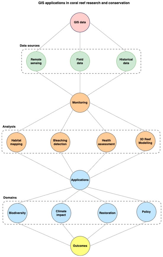
Figure 1.
Framework and integration pathways of GIS in coral reef research: a hierarchical overview of data sources, analysis methods, applications, and domain-specific outcomes.
The Baltic Sea region serves as another example of the importance of GIS in coral reef studies []. Despite meeting sustainability goal 14.5 by 2020, marine protected areas (MPAs) in the open Baltic Sea face unsatisfactory conditions, requiring further protection. Similar challenges are evident in parts of the Russian Federation, where coastal settlements lack protection for their maritime zones. The primary objective is to maintain a healthy coastal and marine environment for future generations while providing recreational opportunities for seaside visitors. To address these issues, researchers selected five Baltic seaside resorts—Karkle, Palanga, Liepaja, Swinoujscie, and Zingst—for a comparative study. These resorts, located in the same climatic zone and near IUCN Category I protected areas, were chosen as potential best practice examples for sustainability and competitiveness goals. The study employed 18 parameters to assess the environmental conditions and touristic attractions’ recreational competitiveness at these resorts from 2010 to 2018. Deficiencies were identified using Delphi techniques and GIS applications [].
GIS plays a crucial role in coral reef studies by enabling researchers to overcome data limitations, assess environmental conditions, and support decision-making processes. The integration of remote sensing and GIS techniques allows for more accurate and comprehensive analyses of coral reef ecosystems, facilitating the development of effective conservation and management strategies. As demonstrated by the studies in Iran and the Baltic Sea region, GIS applications are vital for addressing the challenges faced by marine and coastal environments, ensuring their sustainability for future generations.
Contemporary applications extend beyond traditional mapping paradigms to encompass predictive modelling of climate-driven impacts, utilizing Bayesian frameworks to integrate environmental parameters with reef health indicators []. These models incorporate sophisticated spatial statistics to account for autocorrelation effects and scale-dependent processes inherent in marine systems. The integration of hydrodynamic models with GIS frameworks enables the analysis of connectivity patterns, larval dispersal, and ecosystem resilience factors critical for conservation planning.
The methodological framework necessitates careful consideration of spatial and temporal scale compatibility, with particular attention to error propagation in multi-source data integration. Advanced interpolation techniques, including kriging variants optimised for marine environments, facilitate the integration of point-based field measurements with continuous remotely sensed data. The implementation of standardised metadata frameworks and rigorous quality control protocols ensures data integrity and reproducibility across research applications [].
The integration of machine learning (ML) and deep learning (DL) techniques with multispectral satellite imagery has significantly advanced coral reef monitoring and management. Convolutional neural networks (CNNs), known for their exceptional performance in land cover mapping, have demonstrated superior overall accuracies compared to traditional classification methods such as object-based k-nearest neighbour (OBIA-KNN), support vector machines (OBIA-SVM), and random forests (OBIA-RF) []. These models efficiently extract spatial features from satellite images, enabling precise classification of coral reef habitats. Furthermore, for change detection tasks involving temporal data, long short-term memory networks (LSTMs) and recurrent convolutional neural networks (ReCNNs) have achieved notable success by leveraging temporal dependencies to detect both binary and multi-class land cover changes. Their ability has also surpassed traditional methods, facilitating the detection of coral bleaching events, habitat degradation, and long-term environmental changes [].
Emerging technological paradigms, including cloud-based processing architectures and real-time monitoring systems, are revolutionising the capacity for rapid response to environmental perturbations. These systems integrate with sophisticated decision support frameworks, enabling evidence-based policy formulation and adaptive management strategies. The convergence of artificial intelligence algorithms with traditional GIS frameworks enhances automated feature detection and changing analysis capabilities, particularly in the context of large-scale reef monitoring programs. The technology integration of GIS with coral reef research continues to evolve, driven by advances in sensor technology, computational capabilities, and analytical methodologies. The resulting frameworks provide unprecedented capabilities for understanding reef ecosystem dynamics and implementing effective conservation strategies, while simultaneously presenting new challenges in data management, analysis, and interpretation within the complex marine environment.
Figure 2 highlights the frequency of various GIS applications in coral reef research and conservation efforts. Among these, “habitat mapping” emerges as the most common application, demonstrating its pivotal role in understanding and managing coral reef ecosystems. Other significant applications include monitoring coral bleaching, assessing reef health, and predicting biodiversity hotspots, which collectively aid in addressing climate change impacts and supporting restoration efforts. The visualisation emphasises the versatility of GIS tools in providing data-driven insights essential for sustainable coral reef management and conservation planning. The GIS model has a wide range of applications in sustainability assessment. The analysis of 35 distinct GIS applications documented in coral reef literature demonstrates a clear hierarchical implementation across ten primary domains (refer to Figure 2). Habitat mapping is the most extensively used application, with five documented implementations, underlining its fundamental role in reef ecosystem assessment. Four domains—monitoring coral bleaching, assessing reef health, evaluating climate change impacts, and policy and management support—each exhibit four implementations, indicating their established significance in reef research and management protocols. In the intermediate tier, comprising 3D mapping of reef structures, predicting biodiversity hotspots, supporting restoration efforts, and public engagement and education, each application manifests three implementations, suggesting their growing but specialised adoption. Coral disaster response, with two implementations, represents an emerging application domain, potentially reflecting either methodological novelty or scenario-specific deployment constraints. This distribution pattern illuminates the current state of GIS technology integration in coral reef science, highlighting both well-established methodologies and areas requiring enhanced technological implementation [,].
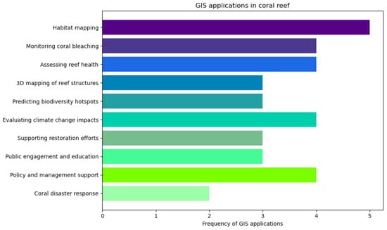
Figure 2.
Frequency distribution of geographic information system (GIS) applications in coral reef research and management.
3. Coral Reef Surveillance with Machine and Deep Learning Methods
The rapid decline of coral reef ecosystems due to climate change, pollution, and human activities has necessitated the development of advanced surveillance methods for effective monitoring and conservation. Geographic information systems (GIS), combined with machine learning (ML) and deep learning (DL) techniques, have emerged as powerful tools for studying and managing coral reef environments. These technologies enable the integration of spatial, temporal, and environmental data, offering unparalleled capabilities for mapping, monitoring, and predicting changes in coral reef health. By leveraging advanced analytical methods, researchers can detect patterns, classify habitats, and forecast future environmental impacts with greater accuracy and efficiency.
The integration of ML and DL methods into GIS-based coral reef studies enhances data analysis by automating complex tasks such as image classification, anomaly detection, and predictive modelling. Through the use of publicly available datasets, researchers gain access to extensive geospatial data, enabling large-scale environmental assessments. Furthermore, AI-driven algorithms in GIS platforms support environmental policymaking, marine biodiversity conservation, and ecosystem restoration by providing critical insights into coral reef dynamics. In the following subsections, we explore publicly accessible datasets essential for GIS-based coral reef studies and review the machine and deep learning methods applied in this field. These advancements demonstrate how cutting-edge technology can transform environmental monitoring, ensuring the sustainability of vital marine ecosystems.
3.1. Publicly Available Dataset for GIS and Coral Reef Studies
Open-access datasets have transformed GIS and coral reef studies by granting researchers and conservationists global access to detailed and location-specific data. These resources enable mapping and analysis of coral reefs and surrounding ecosystems, providing crucial insights into the spatial distribution and health of coral species. By utilising these datasets, researchers can track changes in coral biodiversity and reef extent over time, assess the impacts of climate change and coral bleaching, and identify critical habitats and endangered areas. Furthermore, such data aid in the planning and refinement of marine protected areas, resource management, and environmental impact assessments. Table 1 shows some of the publicly available datasets and includes information, such as the dataset name and ID; the date the dataset was generated; the ocean, area, ecosystem, and ecoregion from which the dataset was collected; and the total quantity of data for each dataset [,]. The spatial distribution of coral reef monitoring data across different parts of the world is presented in Figure 3, while Figure 4 presents data points from two popular jurisdictions: American Samoa and Florida.

Table 1.
Publicly available dataset.
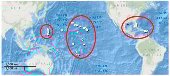
Figure 3.
Spatial distribution of publicly available coral reef monitoring datasets from the NOAA (extracted from []).
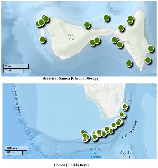
Figure 4.
Coral reef monitoring datasets from Ofu and Olosega islands (American Samoa) and Florida jurisdictions (extracted from []).
The map shown in Figure 3 illustrates the spatial distribution of publicly available coral reef monitoring datasets across the globe. The datasets are concentrated in three primary regions: the Pacific Ocean, including Hawaii and other island chains; the Caribbean and western Atlantic regions; and areas in the central and western Pacific. The red circles highlight these key regions of coral reef monitoring activity, showcasing areas of significant research focus. This distribution reflects the prioritisation of coral reef ecosystems under threat from environmental stressors, underscoring the global efforts to monitor, conserve, and manage these vital marine habitats.
Figure 4 presents the spatial distribution of coral reef monitoring datasets in two key regions: American Samoa and the Florida Keys. The upper map highlights monitoring locations around the Ofu and Olosega islands. These monitoring sites are strategically placed along the islands’ coastlines, emphasizing areas of ecological importance and supporting detailed observations of reef health, biodiversity, and environmental stressors. The lower map showcases monitoring sites distributed across the Florida Keys, a region characterised by its extensive reef tract. The concentrated monitoring efforts in this area reflect its significance as one of the largest coral reef ecosystems in the United States, vital for both marine biodiversity and coastal protection.
The datasets represent observations and specimens of deep-sea corals and sponges observed from the submersibles during different periods. Each database ID corresponds to multiple data sources indicated in the dataset names. The largest Pacific and Western Pacific region databases were collected by the Monterey Bay Aquarium Research Institute, with a total record of 216,993 samples from 1989 to 2015. The largest collection of database repositories worldwide in scope was recorded by the Hawaii Undersea Research Laboratory, University of Hawaii, from 1842 to 2019. The collection represents the largest U.S. Museum collection, with 23,325 coral records and 6053 sponge records.
3.2. Machine and Deep Learning Methods in GIS-Based Coral Reef Studies
The ArcGIS [] platform serves as an integral instrument in understanding the intricate details of coral reef ecosystems. It provides specific tools that are highly valuable in assessing coral characteristics. For instance, the maximum likelihood classification, random trees, and support vector machine methods are used in performing a single analysis. For more complex analyses such as clustering, methodologies like spatially constrained multivariate clustering, density-based clustering, image segmentation, hot spot analysis, cluster and outlier analysis, and space–time pattern mining are employed. Moreover, ArcGIS encompasses forecasting tools like empirical Bayesian kriging, and areal coral reef studies using machine learning models require the analysis of data from a wide range of sources. Figure 5 provides a conceptual model demonstrating the process of predicting coral reef characteristics based on climate variables and time-series data. This model presents insights into how coral traits respond to various climate conditions through machine learning analysis, supporting sustainable development objectives. The machine learning approach to coral reef analysis employs a sophisticated neural network architecture that integrates multiple environmental and climatological features to predict coral characteristics and distress indicators. The model’s feature set encompasses critical climate factors, including thermal stress measurements, sedimentation rates, storm frequency and intensity, precipitation patterns, ocean current dynamics, and pH level variations. The neural network systematically processes these input parameters to generate predictions about coral characteristics and ecosystem responses. The model’s architecture is structured in two distinct stages: training and prediction. During the training phase, the network learns the complex relationships between climate factors and coral responses by analysing labelled data that includes coral characteristics and ecosystem-level attributes. The prediction stage applies this learned knowledge to new climate data, enabling forecasts of potential coral distress manifestations, such as bleaching events, infectious disease outbreaks, smothering incidents, and growth rate alterations. This dual-stage approach ensures robust model validation and reliable predictive capabilities. The implementation leverages deep learning techniques to capture non-linear relationships between environmental stressors and coral health indicators while maintaining the ability to process multiple input features simultaneously.
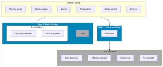
Figure 5.
Hierarchical machine learning framework for coral reef climate response: from environmental feature processing to predictive modeling of coral distress patterns.
Table 2 summarises recent studies that have used machine learning and deep learning models in coral and oyster reef surveillance and gully network detection. In many cases, underwater video data or high-resolution spectral images were collected using unmanned aircraft systems (UAS) or automated vehicles, and after pre-processing, annotated images were fed into machine learning models for training purposes. The use of machine learning models was very promising in terms of achieving better performances and reducing operating costs. Machine learning application to studying corals is multifaceted, but one particularly significant area is the study of how climate change impacts coral reef ecosystems. The idea is to use machine learning models to predict changes in coral characteristics due to evolving climatic conditions, with an eye towards sustainable development goals. These models take into account a wide range of environmental inputs to generate accurate predictions of future coral conditions (refer to Figure 5).
Table 2.
Machine learning for coral reef surveillance.
Figure 6 illustrates the relationship between recent academic research papers and their contributions to various machine learning methods and analytical applications. The visualisation is structured into three main sections: research papers (left), machine learning methods (centre), and types of analysis (right). The central section highlights five key machine learning approaches: convolutional neural networks (CNN), other methods, support vector machines (SVM), random forest (RF), and deep learning. These methods, derived from twelve research papers published between 2018 and 2024, are shown to support five distinct types of analysis: classification, monitoring, optimisation, segmentation, and detection.
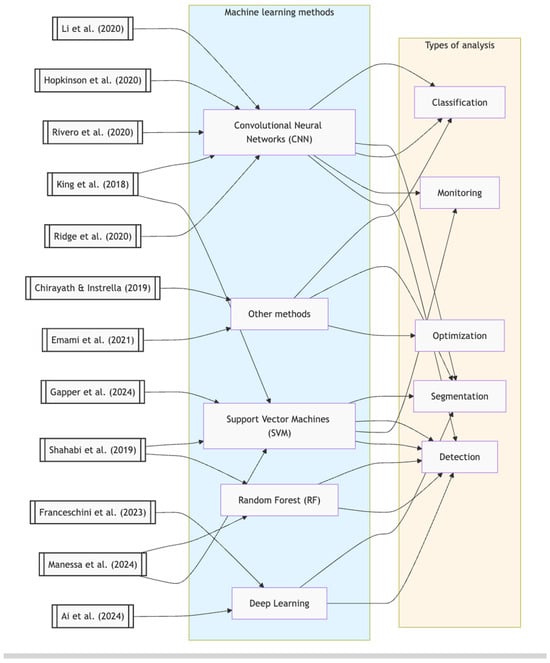
Figure 6.
Machine learning methods and their applications in research: A literature-based analysis framework (2018–2024) [,,,,,,,,,,,].
The field of geospatial analysis benefits greatly from machine learning, a subset of AI. It incorporates an array of predictions, dimension reduction, and clustering techniques, which may or may not involve deep learning. One key application is the identification of corals, where classification and regression methodologies are utilised without necessarily resorting to deep learning. Another specialised branch of machine learning, known as spatial deep learning, utilises multi-layered neural networks for advanced classification tasks and predictive decision-making processes. Some examples include automated navigation systems [], predictive accident probabilities [], and other complex prediction models.
Chirayath and Instrella [] utilised data collected from an airborne fluid lensing field campaign over the coral reefs of Ofu Island, American Samoa, in 2013. The machine learning methods employed in this research included naive Bayes and maximum a posteriori (MAP) estimation, focusing specifically on coral reefs. The study differentiated between living and non-living structures by segmenting coral reefs into four morphological classes. It was suggested that centimetre-scale airborne fluid lensing gave more accurate coral classification results compared to traditional remote sensing methods.
Another study by Emami et al. [] did not utilise a specific dataset. Instead, their research focused on developing optimal operation policies in multi-reservoir systems using Q-learning (a machine learning technique). The researchers proposed two modified versions of the standard coral reef optimisation algorithm (CCR) to reduce calculation costs and adjust reproduction operators. In contrast, King et al. [] used underwater video data collected by swimmers and divers from the coral reefs of the Florida Keys. The machine learning techniques employed in this study included CNN, FCNN, and support vector machines (SVM). The study compared the annotation accuracy of patch-based CNN architectures with SVM models for coral reef images. It was found that CNN-based architecture performed better in this case. The performance of various FCNN architectures for semantic segmentation, which operates on a pixel level, was also investigated.
Li et al. [] utilised a global mosaic generated by the Planet team between October 2017 and September 2018, as well as open-access MCRMP maps. Their research involved the use of CNN and centred on coral reefs. The study reported the development of a globally consistent coral reef probability map, which presents a probabilistic estimation of the reef ecosystem. This was achieved by using CNN and combining global mosaic satellite imagery with MCRMP open-access maps. Hopkinson et al. [] contributed significantly to reef classification by developing an automated approach to classify 3D reconstructions of coral reefs. Their study highlighted that the classifier’s performance varies depending on the taxonomic resolution required and the quality of imagery, pointing to the importance of both image resolution and model adaptability in achieving fine-grained classifications in reef structures. Rivero et al. [] applied convolutional neural networks (CNNs) to analyze large datasets for global coral reef monitoring, revealing substantial agreement with manual evaluations (97%) and achieving this at a fraction of the cost and time traditionally required. This model presents a cost-effective solution to continuous reef monitoring, making it feasible to cover extensive areas without intensive manual input. Similarly, Ridge et al. [] focused on oyster reefs, using CNNs on high-resolution images from unmanned aerial systems (UARS) and specialised cameras to detect and assess reef structures. This tool proved effective in calculating reef heights and densities, with potential for broader applications across various reef ecosystems.
Parsons et al. [] explored UARS-based techniques to evaluate benthic cover and coral growth, particularly useful for remote or shallow areas where traditional observation methods face limitations. This approach enabled efficient data gathering in regions where in-person reef inspection is challenging or impossible, suggesting UARS technology’s broader utility in environmental monitoring. In contrast, addressing erosion detection, Shahabi et al. [] demonstrated the effectiveness of machine learning, using ANN, SVM, and RF models with high-resolution satellite imagery to identify gully networks. The study emphasised the need for precise segmentation and the strategic selection of conditioning factors, underscoring machine learning’s role in identifying subtle landscape features in environmental studies.
Gapper et al. [] considered long-term coral reef monitoring to predict time-based changes in the Red Sea area and used a generalised SVM-based model. Their proposed model achieved 72–78% accuracy. In contrast, Manessa et al. [] assessed the changes in Derawan Island’s coral reef in two decades using data from various sources and compared the performances of RF, SVM, and CART models. RF achieved the best performance among the experimented models, and the accuracy ranged from 71–78%.
Franceschini et al. [] conducted an interesting study where they used deep learning models, specifically Mask R- CNN and U-Net, to measure coral reef halos from satellite images, achieving scalable reef monitoring capabilities on a global scale. In contrast, recently, Ai et al. [] introduced a model that integrates deep learning with radiative transfer for enhanced feature recognition in reef ecosystems. This approach proved particularly effective for distinguishing reef slopes, lagoons, and sandbars, offering improved mapping precision in identifying subtle reef features. These collective advancements demonstrate the transformative potential of machine learning and deep learning in reef and marine ecosystem monitoring, making large-scale detailed environmental assessments more feasible and accurate.
4. Future Research Challenges
Machine learning-based coral reef studies using GIS and remote sensing data are advancing rapidly, but several key challenges remain for future research:
4.1. Data Quality and Availability
One of the key challenges in the study of coral reefs is the poor quality and inadequate coverage of remote sensing observations. It is hard to collect good and labelled data from so many different coral environments. Coral reefs are deep offshore and difficult to reach. Future research should focus on how to improve the quantity and accessibility of data. Collaborative data-collection initiatives and open-access data-collection initiatives for reefs can help. A single worldwide repository of data with standardised formats and metadata can help researchers conduct reliable research globally.
4.2. Spatial and Temporal Resolution
Coral reefs need high-resolution data for effective mapping and tracking. Remote sensing technologies do not always produce detailed images. Future studies can look to enhance the resolution of satellite and aerial photographs. Researchers could use super-resolution algorithms specifically for coral reefs. Another approach is to use drone images with a higher resolution paired with satellite data. This would help create detailed reef maps that show changes over time. The combined datasets may be the key to bridging the gap between the population-level perspective provided by satellites and the fine-scale on-the-ground image needed for effective reef management.
4.3. Data Standardisation
In coral reef studies, data become available in different formats, which makes it hard to make comparisons. Future research can investigate the creation of a global database of the world’s coral reefs in standardised formats and metadata. Automated data harmonisation tools might also be useful, normalising the discrepancies in the way that studies and regions collect data. Standardising data would make it easier to collaborate, share, and reproduce research findings.
4.4. Enhancing Generalizability Across Regions
Models often excel within the constraints of specific datasets but struggle to adapt to varied ecological and geographical conditions. Coral reefs vary significantly in terms of structure, biodiversity, and environmental stressors. Expanding datasets to include underrepresented regions and conditions (e.g., deep reefs and urban-influenced reefs) will be critical to developing models that can be generalised across the globe. Future research should explore transfer learning techniques to improve model adaptability to new environments with minimal retraining.
4.5. Integration of Real-Time Monitoring
Current models rely on static datasets, limiting their ability to respond dynamically to environmental changes. Real-time integration of data streams from autonomous underwater vehicles (AUVs), drones, and satellite platforms would enable immediate detection of stress events such as coral bleaching or outbreaks of crown-of-thorns starfish. This requires not only technical advancements in data acquisition and transmission but also computational frameworks capable of handling and analysing real-time data at scale.
4.6. Algorithm Development
Coral reefs themselves are unique and require unique machine learning algorithms. Future research could explore adaptive transfer learning techniques. These could enable models to learn when they get new data from different areas of the reef. Future research can explore algorithms that can identify and correct regional variations in reef properties. Another focus could be on multi-sensor fusion, which uses data from various sensors at the same time. An attention mechanism in a deep learning model might be able to place different relative sensor inputs according to the reef feature or research question to make a more accurate analysis.
4.7. Scaling Machine Learning Approaches
While high-performance models like HCNN-SVM demonstrate high accuracy, their application to large-scale datasets or entire reef systems presents scalability challenges. Techniques like distributed machine learning, cloud-based computation, and optimisation of neural network architectures for computational efficiency could be explored. Additionally, leveraging edge computing could enable processing directly on data-collection platforms like drones and underwater sensors.
4.8. Automated Annotation of Coral Datasets
Annotated datasets are critical for training machine learning models, yet the process of labelling coral reef imagery is labour-intensive and expensive. Semi-supervised learning, active learning, or unsupervised clustering techniques could reduce the reliance on manual annotations. Furthermore, generative models such as GANs could simulate synthetic datasets to augment training data and improve model performance in underrepresented scenarios.
4.9. Improving Detection in Complex Scenarios
In real-world scenarios, reefs often exist in turbid waters with poor visibility and overlapping features. Models struggle to accurately classify such conditions. Research should prioritise developing robust preprocessing techniques for noise reduction and spectral correction. Models must also be trained on augmented datasets simulating such conditions, ensuring better performance in challenging environments.
4.10. Incorporation of 3D Mapping
Two-dimensional imagery lacks the depth and structural complexity needed for fully understanding reef ecosystems. Techniques like structure from motion (SfM), photogrammetry, and LiDAR can generate high-resolution 3D maps, capturing intricate coral structures. Combining these with machine learning could provide richer spatial and ecological insights, enhancing habitat mapping and structural complexity assessments.
4.11. Ecological Complexity
Coral reef ecosystems are complex, with many different species and interactions. This makes it hard to model them. In species identification, 3D convolutional neural networks (CNNs) could be used in future research to learn the structures of coral colonies. Temporal models could also learn the pattern of how coral appearance evolved in time and get better that way. Understanding the interactions in the ecosystem is also important. Researchers could use graph neural networks (GNNs) to simulate coral reefs as systems of interactions. With machine learning, it could be possible to investigate how a change in one part of the reef affects others.
4.12. Climate Change Impacts
Climate change affects coral reefs. Therefore, predicting and reducing these impacts is important. Future studies could focus on combining climate projections with coral reef data using ensemble models. These models would bring together machine learning and ecological knowledge, making more accurate predictions. Coral bleaching is another area of interest. Researchers could use anomaly detection algorithms to scan multi-spectral satellite images for bleaching before it begins. Models can also differentiate between various bleaching triggers, such as temperature or pollution, from subtle variations in spectral signatures.
4.13. Validation and Ground-Truthing
Good validation and ground-truthing are necessary for accurate models and remote sensing data on coral reefs. Future research could create automated systems to combine in situ data with remote sensing observations in real time. Mobile apps that let divers record and upload observations directly from the field could be developed. This data could then be synchronised with remote sensing data, allowing real-time updates to the models. Researchers could also explore swarm robotics for large-scale reef monitoring. This approach uses small, low-cost underwater robots to work together to survey large areas. Developing AI-powered image processing for autonomous underwater vehicles (AUVs) could help with real-time data analysis and sampling, improving data accuracy.
4.14. Interpretability and Explainability
Coral reef models are increasingly sophisticated, so it is important to make them transparent and accessible. Future research could develop ways to interpret models specifically for coral reef studies. For example, visual explanations that match ecological knowledge could show how models make decisions. Researchers could also create interactive tools for practitioners to test model predictions under different scenarios. This would help practitioners trust the models and make better decisions. Understanding model strengths and limits could improve how machine learning is used in coral reef conservation.
Overall, future research should focus on interdisciplinary teamwork among researchers to combine developments in remote sensing, machine learning, and environmental science. This approach will be important for creating flexible and reliable models that help conserve and manage coral reefs sustainably.
5. Conclusions
This survey highlights the transformative integration of geographic information systems (GIS) with machine learning (ML) and deep learning (DL) in coral reef ecosystem management. By examining publicly available datasets and current technological applications, this review establishes a comprehensive framework for leveraging AI-driven solutions in marine environmental research and conservation. Our analysis reveals significant advancements in using ML methods for coral reef monitoring, particularly through convolutional neural networks (CNN), support vector machines (SVM), and random forests (RF). These technologies have demonstrated remarkable capabilities in habitat mapping, biodiversity assessment, and climate impact predictions. The integration of multiple data sources through GIS platforms has enabled more accurate and efficient environmental monitoring systems, crucial for informed decision-making in marine conservation. Our future work will investigate the experimental validation of existing techniques to make a fair comparison.
Our analysis also revealed several key directions for advancing this field. A primary focus should be on developing standardised data collection protocols and creating unified global databases for coral reef information, including automated data harmonisation tools and consistent metadata frameworks across research institutions. Additionally, there is a pressing need to develop advanced ML algorithms specifically for coral reef environments, incorporating adaptive transfer learning techniques and multi-sensor fusion capabilities designed to handle the unique challenges of underwater environments and varying ecological conditions.
The development of integrated systems combining in situ sensors, remote sensing, and AI-powered analysis for real-time reef monitoring represents another crucial area for advancement. This includes exploring swarm robotics and autonomous underwater vehicles for large-scale data collection. Future research should emphasise predictive modelling capabilities, particularly in forecasting and mitigating climate change impacts on reef ecosystems, including early warning systems for coral bleaching events and other environmental stressors.
Author Contributions
A.C. led the conceptual design of the study and coordinated the review process. He contributed significantly to the sections on machine learning integration, GIS applications, and the development of the analytical framework. M.J. participated in drafting the manuscript, focusing on environmental data analysis and dataset evaluation. S.K. contributed to the design and evaluation of machine learning models, including reviewing technical aspects related to deep learning implementations. He also played a critical role in conducting extensive reviews during all revision stages and finalizing the manuscript drafts. M.E.K. and S.M.A.K.R. provided expertise on GIS-based spatial analysis and remote sensing methodologies, assisting with dataset curation and validation. R.N. contributed to the review of state-of-the-art technologies. All authors collaborated on refining the manuscript, ensuring a comprehensive and multidisciplinary review. All authors have read and agreed to the published version of the manuscript.
Funding
No external funding received.
Conflicts of Interest
The authors declare no conflict of interest.
References
- Cheal, A.J.; MacNeil, M.A.; Emslie, M.J.; Sweatman, H. The threat to coral reefs from more intense cyclones under climate change. Glob. Chang. Biol. 2017, 23, 1511–1524. [Google Scholar] [CrossRef] [PubMed]
- Hoegh-Guldberg, O. The impact of climate change on coral reef ecosystems. In Coral Reefs: An Ecosystem in Transition; Springer: Dordrecht, The Netherlands, 2011; pp. 391–403. [Google Scholar]
- Menon, S.; Bawa, K.S. Applications of geographic information systems, remote-sensing, and a landscape ecology approach to biodiversity conservation in the western ghats. Curr. Sci. 1997, 73, 134–145. [Google Scholar]
- Da Silveira, C.B.L.; Strenzel, G.M.R.; Maida, M.; Gaspar, A.L.B.; Ferreira, B.P. Coral reef mapping with remote sensing and machine learning: A nurture and nature analysis in marine protected areas. Remote Sens. 2021, 13, 2907. [Google Scholar] [CrossRef]
- Burns, C.; Bollard, B.; Narayanan, A. Machine-learning for mapping and monitoring shallow coral reef habitats. Remote Sens. 2022, 14, 2666. [Google Scholar] [CrossRef]
- National Oceanic and Atmospheric Administration. Available online: https://www.noaa.gov/ (accessed on 10 December 2024).
- Monterey Bay Aquarium Research Institute. Available online: https://www.mbari.org/ (accessed on 12 December 2024).
- Hawaii Undersea Research Lab (HURL). Available online: http://www.soest.hawaii.edu/HURL/ (accessed on 12 December 2024).
- Kaisar, S.; Chowdhury, A. Integrating oversampling and ensemble-based machine learning techniques for an imbalanced dataset in dyslexia screening tests. ICT Express 2022, 8, 563–568. [Google Scholar] [CrossRef]
- Shafin, S.S.; Prottoy, S.A.; Abbas, S.; Hakim, S.B.; Chowdhury, A.; Rashid, M.M. Distributed denial of service attack detection using machine learning and class oversampling. In Proceedings of the Applied Intelligence and Informatics: First International Conference, AII 2021, Nottingham, UK, 30–31 July 2021; pp. 247–259. [Google Scholar]
- Shafin, S.S.; Ahmed, M.M.; Pranto, M.A.; Chowdhury, A. Detection of android malware using tree-based ensemble stacking model. In Proceedings of the 2021 IEEE Asia-Pacific Conference on Computer Science and Data Engineering (CSDE), Brisbane, Australia, 8–10 December 2021; pp. 1–6. [Google Scholar]
- Purser, A.; Bergmann, M.; Lunda, T.; Ontrup, J.; Nattkemper, T.W. Use of machine-learning algorithms for the automated detection of cold-water coral habitats: A pilot study. Mar. Ecol. Prog. Ser. 2009, 397, 241–251. [Google Scholar] [CrossRef]
- Zhang, C. Applying data fusion techniques for benthic habitat mapping and monitoring in a coral reef ecosystem. ISPRS J. Photogramm. Remote Sens. 2015, 104, 213–223. [Google Scholar] [CrossRef]
- Boonnam, N.; Udomchaipitak, T.; Puttinaovarat, S.; Chaichana, T.; Boonjing, V.; Muangprathub, J. Coral reef bleaching under climate change: Prediction modelling and machine learning. Sustainability 2022, 14, 6161. [Google Scholar] [CrossRef]
- Nunes, A.C.; Cruz, I.C.; Nunes, A.; Pinheiro, H.T. Speeding up coral reef conservation with ai-aided automated image analysis. Nat. Mach. Intell. 2020, 6, 292. [Google Scholar] [CrossRef]
- Scott, L.M.; Janikas, M.V. Spatial statistics in ArcGIS. In Handbook of Applied Spatial Analysis: Software Tools, Methods and Applications; Springer: Berlin/Heidelberg, Germany, 2009; pp. 27–41. [Google Scholar]
- Strahler, A.H. The use of prior probabilities in maximum likelihood classification of remotely sensed data. Remote Sens. Environ. 1980, 10, 135–163. [Google Scholar] [CrossRef]
- Belgiu, M.; Dra, L. Random forest in remote sensing: A review of applications and future directions. ISPRS J. Photogramm. Remote Sens. 2016, 114, 24–31. [Google Scholar] [CrossRef]
- Mountrakis, G.; Im, J.; Ogole, C. Support vector machines in remote sensing: A review. ISPRS J. Photogramm. Remote Sens. 2011, 66, 247–259. [Google Scholar] [CrossRef]
- Mallik, S.; Bhowmik, T.; Mishra, U.; Paul, N. Mapping and prediction of soil organic carbon by an advanced geostatistical technique using remote sensing and terrain data. Geocarto Int. 2022, 37, 2198–2214. [Google Scholar] [CrossRef]
- Lin, J.; Cromley, R.G.; Civco, D.L.; Hanink, D.M.; Zhang, C. Evaluating the use of publicly available remotely sensed land cover data for areal interpolation. GISci. Remote Sens. 2013, 50, 212–230. [Google Scholar] [CrossRef]
- Yue, Y.; Sun, J.; Liu, X.; Ren, D.; Liu, Q.; Xiao, X.; Lu, L. Spatial analysis of dengue fever and exploration of its environmental and socio-economic risk factors using ordinary least squares: A case study in five districts of Guangzhou city, China, 2014. Int. J. Infect. Dis. 2018, 75, 39–48. [Google Scholar] [CrossRef]
- Feng, Y.; Tong, X. Using exploratory regression to identify optimal driving factors for cellular automaton modelling of land use change. Environ. Monit. Assess. 2017, 189, 515. [Google Scholar] [CrossRef] [PubMed]
- Jo, D.-G. Gis and geographically weighted regression in the survey research of small areas. Surv. Res. 2009, 10, 1–19. [Google Scholar]
- Sharifi, A. Remote sensing and decision support systems. In Spatial Statistics for Remote Sensing; Springer: Berlin/Heidelberg, Germany, 1999; pp. 243–260. [Google Scholar]
- Shinde, P.P.; Shah, S. A review of machine learning and deep learning applications. In Proceedings of the 2018 Fourth International Conference on Computing Communication Control and Automation (ICCUBEA), Pune, India, 16–18 August 2018; pp. 1–6. [Google Scholar]
- Maxwell, A.E.; Warner, T.A.; Fang, F. Implementation of machine-learning classification in remote sensing: An applied review. Int. J. Remote Sens. 2018, 39, 2784–2817. [Google Scholar] [CrossRef]
- Chowdhury, A.; Kaisar, S.; Rashid, M.M.; Shafin, S.S.; Kamruzzaman, J. Churn prediction in telecom industry using machine learning ensembles with class balancing. In Proceedings of the 2021 IEEE Asia-Pacific Conference on Computer Science and Data Engineering (CSDE), Brisbane, Australia, 8–10 December 2021; pp. 1–6. [Google Scholar]
- Radford, B.; Puotinen, M.; Sahin, D.; Boutros, N.; Wyatt, M.; Gilmour, J. A remote sensing model for coral recruitment habitat. Remote Sens. Environ. 2024, 311, 114231. [Google Scholar] [CrossRef]
- Macadam, A.; Nowell, C.J.; Quigley, K. Machine learning for the fast and accurate assessment of fitness in coral early life history. Remote Sens. 2021, 13, 3173. [Google Scholar] [CrossRef]
- Goodman, J.A.; Lay, M.; Ramirez, L.; Ustin, S.L.; Haverkamp, P.J. Confidence levels, sensitivity, and the role of bathymetry in coral reef remote sensing. Remote Sens. 2020, 12, 496. [Google Scholar] [CrossRef]
- Shahabi, H.; Shirzadi, A.; Ghaderi, K.; Omidvar, E.; Al-Ansari, N.; Clague, J.J.; Geertsema, M.; Khosravi, K.; Amini, A.; Bahrami, S.; et al. Flood detection and susceptibility mapping using sentinel-1 remote sensing data and a machine learning approach: Hybrid intelligence of bagging ensemble based on k-nearest neighbor classifier. Remote Sens. 2020, 12, 266. [Google Scholar] [CrossRef]
- Jurkus, E.; Taminskas, J.; Povilanskas, R.; Kontautiene, V.; Baltranaite, E.; Dailide, R.; Urbis, A. Delivering tourism sustainability and competitiveness in seaside and marine resorts with gis. J. Mar. Sci. Eng. 2021, 9, 312. [Google Scholar] [CrossRef]
- Pall, J.; Chandra, R.; Azam, D.; Salles, T.; Webster, J.M.; Scalzo, R.; Cripps, S. Bayesreef: A bayesian inference framework for modelling reef growth in response to environmental change and biological dynamics. Environ. Model. Softw. 2020, 125, 104610. [Google Scholar] [CrossRef]
- Lawrence, A.; Heenan, A.; Levine, A.; Haddaway, N.R.; Powell, F.; Wedding, L.; Roche, R.; Lawrence, P.; Szostek, C.; Ford, H.; et al. Spatial and temporal scales of coral reef fish ecological research and management: A systematic map protocol. Environ. Evid. 2021, 10, 3. [Google Scholar] [CrossRef]
- Cheng, J.; Cheng, L.; Chu, S.; Li, J.; Hu, Q.; Ye, L.; Wang, Z.; Chen, H. A comprehensive evaluation of machine learning and classical approaches for spaceborne active-passive fusion bathymetry of coral reefs. ISPRS Int. J. Geo. Inf. 2023, 12, 381. [Google Scholar] [CrossRef]
- Lin, Y.-C.; Feng, S.-N.; Lai, C.-Y.; Tseng, H.-T.; Huang, C.-W. Applying deep learning to predict sst variation and tropical cyclone patterns that influence coral bleaching. Ecol. Inform. 2023, 77, 102261. [Google Scholar] [CrossRef]
- de Oliveira, L.M.C.; Lim, A.; Conti, L.A.; Wheeler, A.J. High-resolution 3d mapping of cold-water coral reefs using machine learning. Front. Environ. Sci. 2022, 10, 1044706. [Google Scholar] [CrossRef]
- van Woesik, R.; Kratochwill, C. A global coral-bleaching database, 1980–2020. Sci. Data 2022, 9, 20. [Google Scholar] [CrossRef] [PubMed]
- U.S. Government. Coral Data Catalogue. 2024. Available online: https://www.coris.noaa.gov/data/welcome.html (accessed on 12 December 2024).
- National Coral Reef Monitoring Program Climate Dashboard. 2024. Available online: https://www.coris.noaa.gov/activities/archive24.html (accessed on 9 December 2024).
- Chirayath, V.; Instrella, R. Fluid lensing and machine learning for centimetre-resolution airborne assessment of coral reefs in American Samoa. Remote Sens. Environ. 2019, 235, 111475. [Google Scholar] [CrossRef]
- Emami, M.; Nazif, S.; Mousavi, S.-F.; Karami, H.; Daccache, A. A hybrid constrained coral reefs optimization algorithm with machine learning for optimizing multi-reservoir systems operation. J. Environ. Manag. 2021, 286, 112250. [Google Scholar] [CrossRef]
- King, A.; Bhandarkar, S.M.; Hopkinson, B.M. A comparison of deep learning methods for semantic segmentation of coral reef survey images. In Proceedings of the IEEE Conference on Computer Vision and Pattern Recognition Workshops, Salt Lake City, UT, USA, 18–22 June 2018; pp. 1394–1402. [Google Scholar]
- Li, J.; Knapp, D.E.; Fabina, N.S.; Kennedy, E.V.; Larsen, K.; Lyons, M.B.; Murray, N.J.; Phinn, S.R.; Roelfsema, C.M.; Asner, G.P. A global coral reef probability map generated using convolutional neural networks. Coral Reefs 2020, 39, 1805–1815. [Google Scholar] [CrossRef]
- Hopkinson, B.M.; King, A.C.; Owen, D.P.; Johnson-Roberson, M.; Long, M.H.; Bhandarkar, S.M. Automated classification of three-dimensional reconstructions of coral reefs using convolutional neural networks. PLoS ONE 2020, 15, e0230671. [Google Scholar] [CrossRef]
- Rivero, M.G.; Beijbom, O.; Rodriguez-Ramirez, A.; Bryant, D.E.; Ganase, A.; Gonzalez-Marrero, Y.; Herrera-Reveles, A.; Kennedy, E.V.; Kim, C.J.; Lopez-Marcano, S.; et al. Monitoring of coral reefs using artificial intelligence: A feasible and cost-effective approach. Remote Sens. 2020, 12, 489. [Google Scholar] [CrossRef]
- Ridge, J.T.; Gray, P.C.; Windle, A.E.; Johnston, D.W. Deep learning for coastal resource conservation: Automating detection of shellfish reefs. Remote Sens. Ecol. Conserv. 2020, 6, 431–440. [Google Scholar] [CrossRef]
- Parsons, M.; Bratanov, D.; Gaston, K.J.; Gonzalez, F. UAVs, hyperspectral remote sensing, and machine learning revolutionizing reef monitoring. Sensors 2018, 18, 2026. [Google Scholar] [CrossRef] [PubMed]
- Shahabi, H.; Jarihani, B.; Piralilou, S.T.; Chittleborough, D.; Avand, M.; Ghorbanzadeh, O. A semi-automated object-based gully networks detection using different machine learning models: A case study of Bowen catchment, Queensland, Australia. Sensors 2019, 19, 4893. [Google Scholar] [CrossRef] [PubMed]
- Franceschini, S.; Meier, A.C.; Suan, A.; Stokes, K.; Roy, S.; Madin, E.M. A deep learning model for measuring coral reef halos globally from multispectral satellite imagery. Remote Sens. Environ. 2023, 292, 113584. [Google Scholar] [CrossRef]
- Ai, B.; Liu, X.; Wen, Z.; Wang, L.; Ma, H.; Lv, G. A novel coral reef classification method combining radiative transfer model with deep learning. IEEE J. Sel. Top. Appl. Earth Obs. Remote Sens. 2024, 17, 13400–13412. [Google Scholar] [CrossRef]
- Gapper, J.J.; Maharjan, S.; Li, W.; Linstead, E.; Tiwari, S.P.; Qurban, M.A.; El-Askary, H. A generalized machine learning model for long-term coral reef monitoring in the Red Sea. Heliyon 2024, 10, 18. [Google Scholar] [CrossRef] [PubMed]
- Manessa, M.D.M.; Ummam, M.A.F.; Efriana, A.F.; Semedi, J.M.; Ayu, F. Assessing Derawan island’s coral reefs over two decades: A machine learning classification perspective. Sensors 2024, 24, 466. [Google Scholar] [CrossRef]
- Wu, K.; Meng, Q.; Li, R.; Luo, L.; Ke, Q.; Wang, C.; Ma, C. A machine learning-based strategy for predicting the mechanical strength of coral reef limestone using X-ray computed tomography. J. Rock Mech. Geotech. Eng. 2024, 16, 2790–2800. [Google Scholar] [CrossRef]
- Veeranjaneyulu, R.; Govindarajan, D.; Subramanian, C.; Devi, D.U.; Banerjee, S.; Edpuganti, S.K.; Upadhyay, S. Marine ecosystem monitoring: Applying remote sensing and ai to track and predict coral reef health. Remote Sens. Earth Syst. Sci. 2024, 7, 486–499. [Google Scholar] [CrossRef]
- Bagnell, J.A.; Bradley, D.; Silver, D.; Sofman, B.; Stentz, A. Learning for autonomous navigation. IEEE Robot. Autom. Mag. 2010, 17, 74–84. [Google Scholar] [CrossRef]
- Iranitalab, A.; Khattak, A. Comparison of four statistical and machine learning methods for crash severity prediction. Accid. Anal. Prev. 2017, 108, 27–36. [Google Scholar] [CrossRef] [PubMed]
Disclaimer/Publisher’s Note: The statements, opinions and data contained in all publications are solely those of the individual author(s) and contributor(s) and not of MDPI and/or the editor(s). MDPI and/or the editor(s) disclaim responsibility for any injury to people or property resulting from any ideas, methods, instructions or products referred to in the content. |
© 2024 by the authors. Licensee MDPI, Basel, Switzerland. This article is an open access article distributed under the terms and conditions of the Creative Commons Attribution (CC BY) license (https://creativecommons.org/licenses/by/4.0/).