
Coral Reef Surveillance with Machine Learning: A Review of Datasets, Techniques, and Challenges

 ,
,  ,
, 
Abstract
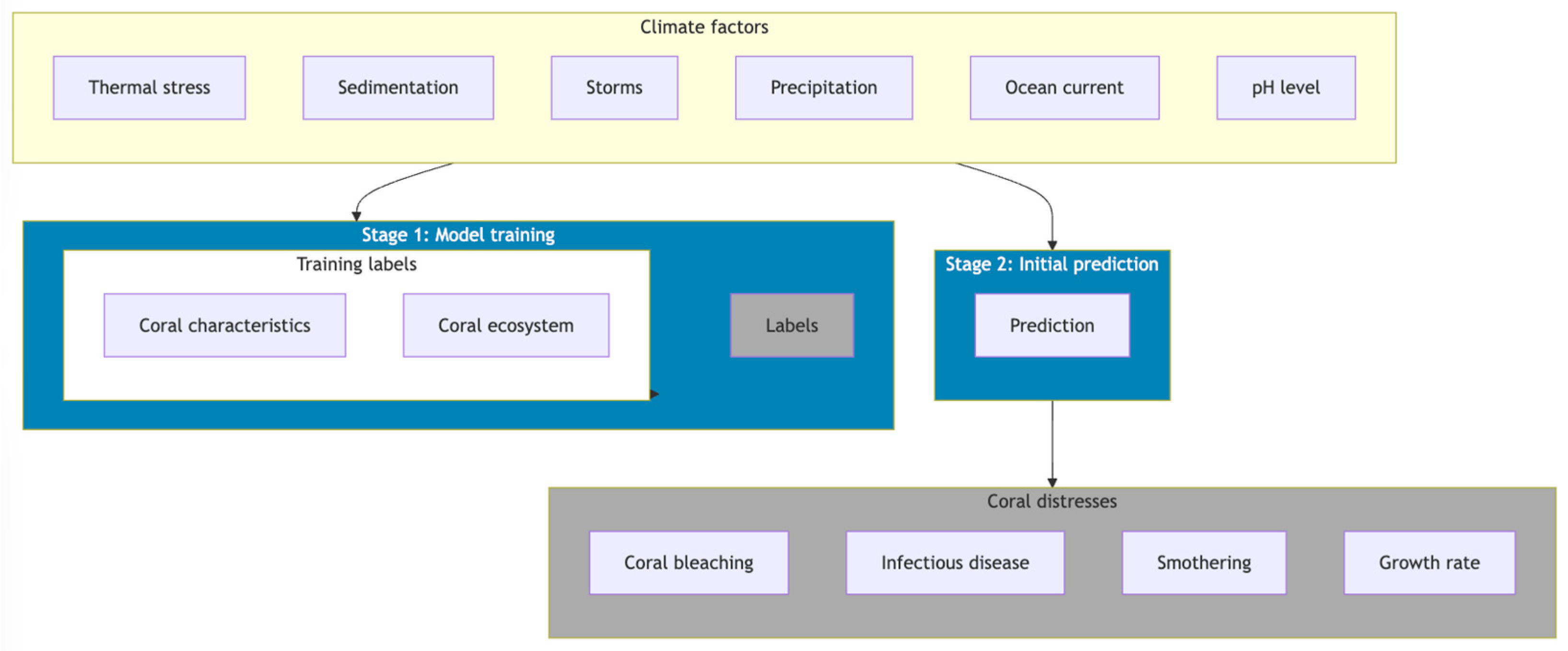
1. Introduction
- Investigating the application of GIS technology in coral reef surveillance, analysing its usage across various contexts.
- Providing a comprehensive analysis of publicly available datasets for coral reef management, detailing their sources, locations, and types to support future research.
- Reviewing the application of machine and deep learning models in coral reef surveillance, highlighting state-of-the-art methods and their use for monitoring, classification, optimisation, segmentation, and detection.
- Offering insights that promote informed and efficient approaches to coral reef management and conservation.
2. Applications of GIS in Coral Reef Studies
3. Coral Reef Surveillance with Machine and Deep Learning Methods
3.1. Publicly Available Dataset for GIS and Coral Reef Studies
3.2. Machine and Deep Learning Methods in GIS-Based Coral Reef Studies
4. Future Research Challenges
4.1. Data Quality and Availability
4.2. Spatial and Temporal Resolution
4.3. Data Standardisation
4.4. Enhancing Generalizability Across Regions
4.5. Integration of Real-Time Monitoring
4.6. Algorithm Development
4.7. Scaling Machine Learning Approaches
4.8. Automated Annotation of Coral Datasets
4.9. Improving Detection in Complex Scenarios
4.10. Incorporation of 3D Mapping
4.11. Ecological Complexity
4.12. Climate Change Impacts
4.13. Validation and Ground-Truthing
4.14. Interpretability and Explainability
5. Conclusions
Author Contributions
Funding
Conflicts of Interest
References
- Cheal, A.J.; MacNeil, M.A.; Emslie, M.J.; Sweatman, H. The threat to coral reefs from more intense cyclones under climate change. Glob. Chang. Biol. 2017, 23, 1511–1524. [Google Scholar] [CrossRef] [PubMed]
- Hoegh-Guldberg, O. The impact of climate change on coral reef ecosystems. In Coral Reefs: An Ecosystem in Transition; Springer: Dordrecht, The Netherlands, 2011; pp. 391–403. [Google Scholar]
- Menon, S.; Bawa, K.S. Applications of geographic information systems, remote-sensing, and a landscape ecology approach to biodiversity conservation in the western ghats. Curr. Sci. 1997, 73, 134–145. [Google Scholar]
- Da Silveira, C.B.L.; Strenzel, G.M.R.; Maida, M.; Gaspar, A.L.B.; Ferreira, B.P. Coral reef mapping with remote sensing and machine learning: A nurture and nature analysis in marine protected areas. Remote Sens. 2021, 13, 2907. [Google Scholar] [CrossRef]
- Burns, C.; Bollard, B.; Narayanan, A. Machine-learning for mapping and monitoring shallow coral reef habitats. Remote Sens. 2022, 14, 2666. [Google Scholar] [CrossRef]
- National Oceanic and Atmospheric Administration. Available online: https://www.noaa.gov/ (accessed on 10 December 2024).
- Monterey Bay Aquarium Research Institute. Available online: https://www.mbari.org/ (accessed on 12 December 2024).
- Hawaii Undersea Research Lab (HURL). Available online: http://www.soest.hawaii.edu/HURL/ (accessed on 12 December 2024).
- Kaisar, S.; Chowdhury, A. Integrating oversampling and ensemble-based machine learning techniques for an imbalanced dataset in dyslexia screening tests. ICT Express 2022, 8, 563–568. [Google Scholar] [CrossRef]
- Shafin, S.S.; Prottoy, S.A.; Abbas, S.; Hakim, S.B.; Chowdhury, A.; Rashid, M.M. Distributed denial of service attack detection using machine learning and class oversampling. In Proceedings of the Applied Intelligence and Informatics: First International Conference, AII 2021, Nottingham, UK, 30–31 July 2021; pp. 247–259. [Google Scholar]
- Shafin, S.S.; Ahmed, M.M.; Pranto, M.A.; Chowdhury, A. Detection of android malware using tree-based ensemble stacking model. In Proceedings of the 2021 IEEE Asia-Pacific Conference on Computer Science and Data Engineering (CSDE), Brisbane, Australia, 8–10 December 2021; pp. 1–6. [Google Scholar]
- Purser, A.; Bergmann, M.; Lunda, T.; Ontrup, J.; Nattkemper, T.W. Use of machine-learning algorithms for the automated detection of cold-water coral habitats: A pilot study. Mar. Ecol. Prog. Ser. 2009, 397, 241–251. [Google Scholar] [CrossRef]
- Zhang, C. Applying data fusion techniques for benthic habitat mapping and monitoring in a coral reef ecosystem. ISPRS J. Photogramm. Remote Sens. 2015, 104, 213–223. [Google Scholar] [CrossRef]
- Boonnam, N.; Udomchaipitak, T.; Puttinaovarat, S.; Chaichana, T.; Boonjing, V.; Muangprathub, J. Coral reef bleaching under climate change: Prediction modelling and machine learning. Sustainability 2022, 14, 6161. [Google Scholar] [CrossRef]
- Nunes, A.C.; Cruz, I.C.; Nunes, A.; Pinheiro, H.T. Speeding up coral reef conservation with ai-aided automated image analysis. Nat. Mach. Intell. 2020, 6, 292. [Google Scholar] [CrossRef]
- Scott, L.M.; Janikas, M.V. Spatial statistics in ArcGIS. In Handbook of Applied Spatial Analysis: Software Tools, Methods and Applications; Springer: Berlin/Heidelberg, Germany, 2009; pp. 27–41. [Google Scholar]
- Strahler, A.H. The use of prior probabilities in maximum likelihood classification of remotely sensed data. Remote Sens. Environ. 1980, 10, 135–163. [Google Scholar] [CrossRef]
- Belgiu, M.; Dra, L. Random forest in remote sensing: A review of applications and future directions. ISPRS J. Photogramm. Remote Sens. 2016, 114, 24–31. [Google Scholar] [CrossRef]
- Mountrakis, G.; Im, J.; Ogole, C. Support vector machines in remote sensing: A review. ISPRS J. Photogramm. Remote Sens. 2011, 66, 247–259. [Google Scholar] [CrossRef]
- Mallik, S.; Bhowmik, T.; Mishra, U.; Paul, N. Mapping and prediction of soil organic carbon by an advanced geostatistical technique using remote sensing and terrain data. Geocarto Int. 2022, 37, 2198–2214. [Google Scholar] [CrossRef]
- Lin, J.; Cromley, R.G.; Civco, D.L.; Hanink, D.M.; Zhang, C. Evaluating the use of publicly available remotely sensed land cover data for areal interpolation. GISci. Remote Sens. 2013, 50, 212–230. [Google Scholar] [CrossRef]
- Yue, Y.; Sun, J.; Liu, X.; Ren, D.; Liu, Q.; Xiao, X.; Lu, L. Spatial analysis of dengue fever and exploration of its environmental and socio-economic risk factors using ordinary least squares: A case study in five districts of Guangzhou city, China, 2014. Int. J. Infect. Dis. 2018, 75, 39–48. [Google Scholar] [CrossRef]
- Feng, Y.; Tong, X. Using exploratory regression to identify optimal driving factors for cellular automaton modelling of land use change. Environ. Monit. Assess. 2017, 189, 515. [Google Scholar] [CrossRef] [PubMed]
- Jo, D.-G. Gis and geographically weighted regression in the survey research of small areas. Surv. Res. 2009, 10, 1–19. [Google Scholar]
- Sharifi, A. Remote sensing and decision support systems. In Spatial Statistics for Remote Sensing; Springer: Berlin/Heidelberg, Germany, 1999; pp. 243–260. [Google Scholar]
- Shinde, P.P.; Shah, S. A review of machine learning and deep learning applications. In Proceedings of the 2018 Fourth International Conference on Computing Communication Control and Automation (ICCUBEA), Pune, India, 16–18 August 2018; pp. 1–6. [Google Scholar]
- Maxwell, A.E.; Warner, T.A.; Fang, F. Implementation of machine-learning classification in remote sensing: An applied review. Int. J. Remote Sens. 2018, 39, 2784–2817. [Google Scholar] [CrossRef]
- Chowdhury, A.; Kaisar, S.; Rashid, M.M.; Shafin, S.S.; Kamruzzaman, J. Churn prediction in telecom industry using machine learning ensembles with class balancing. In Proceedings of the 2021 IEEE Asia-Pacific Conference on Computer Science and Data Engineering (CSDE), Brisbane, Australia, 8–10 December 2021; pp. 1–6. [Google Scholar]
- Radford, B.; Puotinen, M.; Sahin, D.; Boutros, N.; Wyatt, M.; Gilmour, J. A remote sensing model for coral recruitment habitat. Remote Sens. Environ. 2024, 311, 114231. [Google Scholar] [CrossRef]
- Macadam, A.; Nowell, C.J.; Quigley, K. Machine learning for the fast and accurate assessment of fitness in coral early life history. Remote Sens. 2021, 13, 3173. [Google Scholar] [CrossRef]
- Goodman, J.A.; Lay, M.; Ramirez, L.; Ustin, S.L.; Haverkamp, P.J. Confidence levels, sensitivity, and the role of bathymetry in coral reef remote sensing. Remote Sens. 2020, 12, 496. [Google Scholar] [CrossRef]
- Shahabi, H.; Shirzadi, A.; Ghaderi, K.; Omidvar, E.; Al-Ansari, N.; Clague, J.J.; Geertsema, M.; Khosravi, K.; Amini, A.; Bahrami, S.; et al. Flood detection and susceptibility mapping using sentinel-1 remote sensing data and a machine learning approach: Hybrid intelligence of bagging ensemble based on k-nearest neighbor classifier. Remote Sens. 2020, 12, 266. [Google Scholar] [CrossRef]
- Jurkus, E.; Taminskas, J.; Povilanskas, R.; Kontautiene, V.; Baltranaite, E.; Dailide, R.; Urbis, A. Delivering tourism sustainability and competitiveness in seaside and marine resorts with gis. J. Mar. Sci. Eng. 2021, 9, 312. [Google Scholar] [CrossRef]
- Pall, J.; Chandra, R.; Azam, D.; Salles, T.; Webster, J.M.; Scalzo, R.; Cripps, S. Bayesreef: A bayesian inference framework for modelling reef growth in response to environmental change and biological dynamics. Environ. Model. Softw. 2020, 125, 104610. [Google Scholar] [CrossRef]
- Lawrence, A.; Heenan, A.; Levine, A.; Haddaway, N.R.; Powell, F.; Wedding, L.; Roche, R.; Lawrence, P.; Szostek, C.; Ford, H.; et al. Spatial and temporal scales of coral reef fish ecological research and management: A systematic map protocol. Environ. Evid. 2021, 10, 3. [Google Scholar] [CrossRef]
- Cheng, J.; Cheng, L.; Chu, S.; Li, J.; Hu, Q.; Ye, L.; Wang, Z.; Chen, H. A comprehensive evaluation of machine learning and classical approaches for spaceborne active-passive fusion bathymetry of coral reefs. ISPRS Int. J. Geo. Inf. 2023, 12, 381. [Google Scholar] [CrossRef]
- Lin, Y.-C.; Feng, S.-N.; Lai, C.-Y.; Tseng, H.-T.; Huang, C.-W. Applying deep learning to predict sst variation and tropical cyclone patterns that influence coral bleaching. Ecol. Inform. 2023, 77, 102261. [Google Scholar] [CrossRef]
- de Oliveira, L.M.C.; Lim, A.; Conti, L.A.; Wheeler, A.J. High-resolution 3d mapping of cold-water coral reefs using machine learning. Front. Environ. Sci. 2022, 10, 1044706. [Google Scholar] [CrossRef]
- van Woesik, R.; Kratochwill, C. A global coral-bleaching database, 1980–2020. Sci. Data 2022, 9, 20. [Google Scholar] [CrossRef] [PubMed]
- U.S. Government. Coral Data Catalogue. 2024. Available online: https://www.coris.noaa.gov/data/welcome.html (accessed on 12 December 2024).
- National Coral Reef Monitoring Program Climate Dashboard. 2024. Available online: https://www.coris.noaa.gov/activities/archive24.html (accessed on 9 December 2024).
- Chirayath, V.; Instrella, R. Fluid lensing and machine learning for centimetre-resolution airborne assessment of coral reefs in American Samoa. Remote Sens. Environ. 2019, 235, 111475. [Google Scholar] [CrossRef]
- Emami, M.; Nazif, S.; Mousavi, S.-F.; Karami, H.; Daccache, A. A hybrid constrained coral reefs optimization algorithm with machine learning for optimizing multi-reservoir systems operation. J. Environ. Manag. 2021, 286, 112250. [Google Scholar] [CrossRef]
- King, A.; Bhandarkar, S.M.; Hopkinson, B.M. A comparison of deep learning methods for semantic segmentation of coral reef survey images. In Proceedings of the IEEE Conference on Computer Vision and Pattern Recognition Workshops, Salt Lake City, UT, USA, 18–22 June 2018; pp. 1394–1402. [Google Scholar]
- Li, J.; Knapp, D.E.; Fabina, N.S.; Kennedy, E.V.; Larsen, K.; Lyons, M.B.; Murray, N.J.; Phinn, S.R.; Roelfsema, C.M.; Asner, G.P. A global coral reef probability map generated using convolutional neural networks. Coral Reefs 2020, 39, 1805–1815. [Google Scholar] [CrossRef]
- Hopkinson, B.M.; King, A.C.; Owen, D.P.; Johnson-Roberson, M.; Long, M.H.; Bhandarkar, S.M. Automated classification of three-dimensional reconstructions of coral reefs using convolutional neural networks. PLoS ONE 2020, 15, e0230671. [Google Scholar] [CrossRef]
- Rivero, M.G.; Beijbom, O.; Rodriguez-Ramirez, A.; Bryant, D.E.; Ganase, A.; Gonzalez-Marrero, Y.; Herrera-Reveles, A.; Kennedy, E.V.; Kim, C.J.; Lopez-Marcano, S.; et al. Monitoring of coral reefs using artificial intelligence: A feasible and cost-effective approach. Remote Sens. 2020, 12, 489. [Google Scholar] [CrossRef]
- Ridge, J.T.; Gray, P.C.; Windle, A.E.; Johnston, D.W. Deep learning for coastal resource conservation: Automating detection of shellfish reefs. Remote Sens. Ecol. Conserv. 2020, 6, 431–440. [Google Scholar] [CrossRef]
- Parsons, M.; Bratanov, D.; Gaston, K.J.; Gonzalez, F. UAVs, hyperspectral remote sensing, and machine learning revolutionizing reef monitoring. Sensors 2018, 18, 2026. [Google Scholar] [CrossRef] [PubMed]
- Shahabi, H.; Jarihani, B.; Piralilou, S.T.; Chittleborough, D.; Avand, M.; Ghorbanzadeh, O. A semi-automated object-based gully networks detection using different machine learning models: A case study of Bowen catchment, Queensland, Australia. Sensors 2019, 19, 4893. [Google Scholar] [CrossRef] [PubMed]
- Franceschini, S.; Meier, A.C.; Suan, A.; Stokes, K.; Roy, S.; Madin, E.M. A deep learning model for measuring coral reef halos globally from multispectral satellite imagery. Remote Sens. Environ. 2023, 292, 113584. [Google Scholar] [CrossRef]
- Ai, B.; Liu, X.; Wen, Z.; Wang, L.; Ma, H.; Lv, G. A novel coral reef classification method combining radiative transfer model with deep learning. IEEE J. Sel. Top. Appl. Earth Obs. Remote Sens. 2024, 17, 13400–13412. [Google Scholar] [CrossRef]
- Gapper, J.J.; Maharjan, S.; Li, W.; Linstead, E.; Tiwari, S.P.; Qurban, M.A.; El-Askary, H. A generalized machine learning model for long-term coral reef monitoring in the Red Sea. Heliyon 2024, 10, 18. [Google Scholar] [CrossRef] [PubMed]
- Manessa, M.D.M.; Ummam, M.A.F.; Efriana, A.F.; Semedi, J.M.; Ayu, F. Assessing Derawan island’s coral reefs over two decades: A machine learning classification perspective. Sensors 2024, 24, 466. [Google Scholar] [CrossRef]
- Wu, K.; Meng, Q.; Li, R.; Luo, L.; Ke, Q.; Wang, C.; Ma, C. A machine learning-based strategy for predicting the mechanical strength of coral reef limestone using X-ray computed tomography. J. Rock Mech. Geotech. Eng. 2024, 16, 2790–2800. [Google Scholar] [CrossRef]
- Veeranjaneyulu, R.; Govindarajan, D.; Subramanian, C.; Devi, D.U.; Banerjee, S.; Edpuganti, S.K.; Upadhyay, S. Marine ecosystem monitoring: Applying remote sensing and ai to track and predict coral reef health. Remote Sens. Earth Syst. Sci. 2024, 7, 486–499. [Google Scholar] [CrossRef]
- Bagnell, J.A.; Bradley, D.; Silver, D.; Sofman, B.; Stentz, A. Learning for autonomous navigation. IEEE Robot. Autom. Mag. 2010, 17, 74–84. [Google Scholar] [CrossRef]
- Iranitalab, A.; Khattak, A. Comparison of four statistical and machine learning methods for crash severity prediction. Accid. Anal. Prev. 2017, 108, 27–36. [Google Scholar] [CrossRef] [PubMed]


| DatasetID | Records | Dataset Name | Observation Year | Ocean | Ecosystem(s) | Ecoregion(s) |
|---|---|---|---|---|---|---|
| DWH NRDA HC-11-09 | 811 | Deep Water Horizon, Natural Resources Damage Assessment, Holiday Chouest | September 2011 | North Atlantic | Gulf of Mexico | Northern Gulf of Mexico |
| DWH NRDA WS-14-06 | 1834 | Deep Water Horizon, Natural Resources Damage Assessment, Walton Smith | June 2014 | North Atlantic | Gulf of Mexico | Northern Gulf of Mexico |
| ECOGIG OI-16-10 | 138 | Ecosystem Impacts of Oil and Gas Inputs to the Gulf, Ocean Inspector | September 2016 | North Atlantic | Gulf of Mexico | Northern Gulf of Mexico |
| HBOI SJ-06-02 | 314 | Harbor Branch Oceanographic Institute, Seward Johnson | March 2006 Observation date range: 2005 to 2006 | North Atlantic | Southeast U.S. Continental Shelf, Caribbean Sea | Bahamian, Floridian |
| HBOI SJ-10-07 | 818 | Harbor Branch Oceanographic Institute, Seward Johnson | July 2010 | North Atlantic | Gulf of Mexico, Caribbean Sea | Floridian, Northern Gulf of Mexico |
| HBOI WS-17-125 | 4541 | Harbor Branch Oceanographic Institute, Cuba, Walton Smith | May–June, 2017 | North Atlantic | Caribbean Sea | Greater Antilles |
| NOAA AP-13-08 | 741 | National Oceanic and Atmospheric Administration, Alaska Provider | August 2013 | North Pacific | Gulf of Alaska | North American Pacific Fjordland |
| NOAA AT-02- 06-L15 | 1811 | National Oceanic and Atmospheric Administration, Atlantis R/V—Alvin Submersible | June 2002, | North Pacific | Gulf of Alaska | Gulf of Alaska |
| NOAA AT-04-08 | 2542 | National Oceanic and Atmospheric Administration, Atlantis R/V—Alvin Submersible | August 2004 | North Pacific | Gulf of Alaska | North American Pacific Fjordland |
| NOAA CT-15-07 | 1388 | National Oceanic and Atmospheric Administration, Northeast Fisheries Science Center, University of Connecticut, Gulf of Maine | 2015 | North Atlantic | Northeast U.S. Continental Shelf | Gulf of Maine/Bay of Fundy |
| NOAA DFO TU- 08-07 | 24,269 | National Oceanic and Atmospheric Administration and Fisheries and Oceans Canada, Tully | July 2008 | North Pacific | Gulf of Alaska | Oregon, Washington, Vancouver Coast and Shelf |
| NOAA EX-15-04-L2 | 13,578 | National Oceanic and Atmospheric Administration, Deep-sea coral and sponge records from Okeanos Explorer cruise | July 2015 | North Pacific | Insular Pacific-Hawaiian | Hawaii |
| NOAA EX-19-03-L2 | 4669 | National Oceanic and Atmospheric Administration, Leg 2 of Windows to the Deep 2019: Exploration of the Deep-sea Habitats of the Southeastern United States; Okeanos Explorer | June–July 2019 | North Atlantic | Southeast U.S. Continental Shelf, Northeast U.S. Continental Shelf | Bahamian, Carolinian, Virginian |
| NOAA FGBNMS PSBF-II | 19 | Bureau of Ocean Energy Management, Manta | September 2012 | North Atlantic | Gulf of Mexico | Northern Gulf of Mexico |
| NOAA GFNMS CBNMS SH-18-09 | 8612 | National Oceanic and Atmospheric Administration, Characterization of Cordell Bank, and Continental Shelf and Slope; Bell M. Shimada | August 2018 | North Pacific | California Current | Northern California |
| NOAA NF-19-01 | 2256 | National Oceanic and Atmospheric Administration, Mapping Essential Fish Habitat in the US Caribbean to Inform MPA Management; Nancy Foster | July 2019 | North Atlantic | Caribbean Sea | Eastern Caribbean, Greater Antilles |
| NOAA PU-11-08 | 14,504 | National Oceanic and Atmospheric Administration, Point Sur | August 2011 | North Pacific | California Current | Oregon, Washington, Vancouver Coast and Shelf, northern North-ern California |
| NOAA RR-04-07 | 15,094 | National Oceanic and Atmospheric Administration, Roger Revelle | September 2004 | North Pacific | Aleutian Islands | Aleutian Islands |
| Article | Dataset | ML/DL Methods | Area of Focus | Performance Evaluation | Research Description and Findings |
|---|---|---|---|---|---|
| Fluid Lensing and ML [42] | Airborne fluid lensing field campaign from the coral reef of Ofu Island, American Samoa, collected in 2013. | Naive Bayes maximum a posteriori (MAP) estimation | Coral reef | 92% accuracy for coral morphology classification and 95% for distinguishing living from non-living structures. | Separated living and non-living structures, segmented coral reef into four morphological classes and suggested that cm-scale airborne fluid lensing yielded better results for coral classification compared to remote sensing methods. |
| Multi-reservoir systems [43] | Worm reef (Sabellaria vulgaris) formation, collected in 2020. | Q-learning | Multi- reservoir systems | Compared the benefit performance of four algorithms, with constrained. CRO with Q-Learning delivering the best results. | Investigated optimal operation policies in multi-reservoir systems and proposed two modified versions of the standard coral reef optimisation algorithm (CCR) to reduce calculation cost and adjust reproduction operators. |
| Semantic Segmentation with DL [44] | Underwater video data collected by swimmers and divers from coral reefs of the Florida Keys. | CNN, FCNN, and SVM | Coral reef | ResNet152 achieved the best result with 90.03% classification accuracy. | Compared annotation accuracy of patch-based CNN architectures with SVM models for coral reef images and suggested that CNN-based architectures perform better in this case and further investigated the performance of various FCNN architectures for semantic segmentation, which operates on pixel level. |
| Coral reef probability map [45] | Global mosaic generated by the Planet team between October 2017-September’2018, an open-access MCRMP maps. | CNN | Coral reef | The proposed model achieved an accuracy of 87.3%, a precision of 0.77, a recall of 0.58, and an F1-score of 0.66. | Reported the development of a globally consistent coral reef probability map, which presents a probabilistic estimation of the reef ecosystem, by using CNN and combining global mosaic satellite imagery with MCRMP open-access maps. |
| Classification of 3D reconstruction [46] | Underwater video data collected by a swimmer from coral reefs of Florida Keys. | CNN | Coral reef | All tested methods (voting, probability averaging, and neural network nViewNet) achieved a high classification accuracy of approximately 96%. | Developed a machine learning-based approach to automatically classify 3D reconstruction of reef sections and suggested that the performance of classifiers depend on the desired taxonomic resolution and the quality and scale of input images. |
| Coral reef monitoring [47] | Underwater images collected using diver propulsion vehicle from five different global regions from 2012 to 2016. | CNN | Coral reef | Reported an agreement of 97% between automated and manual coral reef image annotations and 83–94% similarity in community composition across different global bioregions. | Evaluated the performance of CNN for automated image analysis of the global coral reef monitoring dataset and suggested that both expert and automated observation produces high agreement (97%) while the automated process is 200 times faster and costs 1% of the manual process. |
| Detection of shellfish reefs [48] | High-resolution images were collected from Rachel Carson Reserve. using UAS and S.O.D.A. camera during 2018 | CNN | Oyster reef | OysterNet CNN achieved a precision of 0.771 and a recall of 0.772. Digital delineation with GIS tools was significantly faster, requiring 26 h. | Developed a tool to detect and delineate oyster reefs using CNN where the dataset is collected from UAS and suggested that the developed tool can be further used to assess reef heights and densities. |
| Revolutionizing reef monitoring [49] | In-water surveys and images collected from Pandora Reef, Queensland using UAS in 2017. | SVM | Coral reef | Achieved high accuracy of up to 100% for different coral types. | Introduced a UAS-based remote sensing technique for coral reef surveillance to assess the level of benthic cover and coral growth in shallow water reef regions and suggested that such techniques will be effective where visual inspection is difficult or impossible. |
| Object-based Gully networks detection [50] | High-resolution images collected from Google Earth and Planet Scope. | ANN, SVM, And RF | Gully | Stacking model achieved the best performance with precision of 0.84, recall of 0.95, and F1-Score of 0.89. | Employed geographic object-based image analysis and machine learning methods to detect gully networks and suggested that issues, such as the selection of conditioning factors and image segmentation quality, are very important. |
| Measuring Coral Reef Hallos [51] | Satellite images from Planet Inc. | Mask R-CNN, U-net | Coral reef halos | Mask R-CNN Model achieved a precision of 0.97, recall of 0.55, and F1-score of 0.66. | Introduces a deep learning model to measure coral reef halos globally, which improves the efficiency and scale of monitoring reef ecosystems. |
| Radiative transfer model with deep learning [52] | Sentinel-2 satellite image from the European Space Agency. | Radiative transfer model with deep learning | Coral reef | The radiative transfer model with deep learning (RTDL) improved 5% in accuracy compared to the traditional model. | Presented a novel deep learning-based model that integrates the radiative transfer method to improve accuracy. Results show improvement in recognizing reef front slopes, lagoons, and sandbars. |
| Long term monitoring [53] | Landsat 7 and Landsat 8 data | SVM | Coral reef | Classification accuracy ranged from 70 to 78% for different regions | Focused on the Red Sea and proposed a generalised ML model using SVM to predict time-based change over 18 years. |
| Machine learning classification [54] | Landsat 7, Landsat 9 images, Sentinel2 dataset, multispectral aerial photography, and underwater photo Transects. | RF, SVM, and CART | Coral reef | SVM achieved the highest accuracy of 78.28% for aerial photography. | Employed data obtained from various sources and machine learning algorithms to assess temporal and spatial changes in coral reef habitats over two decades where RF model demonstrated the best performance. |
| Predicting the mechanical strength of coral reef [55] | 112 Coral reef limestone (CRL) samples. | SVM, RF, and BPNN | Coral reef | BPNN achieved the best performance across all performance metrics. | Proposes a novel machine learning approach to predict the mechanical strength of coral reef limestone by integrating X-ray computed tomography (CT) data with SVM, RF, and BPNN models. |
| Predict coral reef health [56] | Images from CoralNet and the Moorea coral reef long-term ecological research. | Hybrid model with CNN and SVM | Coral reef | The HCNN-SVM model achieved the highest accuracy of 98.55%. | Introduced a hybrid model combining CNN for feature extraction and SVM for classification and achieved an accuracy of 98.55%. |
Disclaimer/Publisher’s Note: The statements, opinions and data contained in all publications are solely those of the individual author(s) and contributor(s) and not of MDPI and/or the editor(s). MDPI and/or the editor(s) disclaim responsibility for any injury to people or property resulting from any ideas, methods, instructions or products referred to in the content. |
© 2024 by the authors. Licensee MDPI, Basel, Switzerland. This article is an open access article distributed under the terms and conditions of the Creative Commons Attribution (CC BY) license (https://creativecommons.org/licenses/by/4.0/).
Share and Cite
Chowdhury, A.; Jahan, M.; Kaisar, S.; Khoda, M.E.; Rajin, S.M.A.K.; Naha, R. Coral Reef Surveillance with Machine Learning: A Review of Datasets, Techniques, and Challenges. Electronics 2024, 13, 5027. https://doi.org/10.3390/electronics13245027
Chowdhury A, Jahan M, Kaisar S, Khoda ME, Rajin SMAK, Naha R. Coral Reef Surveillance with Machine Learning: A Review of Datasets, Techniques, and Challenges. Electronics. 2024; 13(24):5027. https://doi.org/10.3390/electronics13245027
Chicago/Turabian StyleChowdhury, Abdullahi, Musfera Jahan, Shahriar Kaisar, Mahbub E. Khoda, S M Ataul Karim Rajin, and Ranesh Naha. 2024. "Coral Reef Surveillance with Machine Learning: A Review of Datasets, Techniques, and Challenges" Electronics 13, no. 24: 5027. https://doi.org/10.3390/electronics13245027
APA StyleChowdhury, A., Jahan, M., Kaisar, S., Khoda, M. E., Rajin, S. M. A. K., & Naha, R. (2024). Coral Reef Surveillance with Machine Learning: A Review of Datasets, Techniques, and Challenges. Electronics, 13(24), 5027. https://doi.org/10.3390/electronics13245027