Abstract
Raising awareness and understanding of climate change among younger generations is crucial for building a sustainable future. The Laboratory of Atmospheric Physics (LAP) within the School of Physics of the Aristotle University of Thessaloniki (AUTh) supports this goal by developing innovative educational activities centered on atmospheric processes and climate science. Drawing on its expertise in atmospheric monitoring and remote sensing, LAP makes complex scientific concepts accessible to school students through interactive workshops, hands-on experiments, and data-driven projects using real-time environmental measurements. By integrating research-grade tools and open-access satellite data from ESA, NASA, and EUMETSAT, LAP bridges academic research and public understanding. These activities foster critical thinking, environmental responsibility, and student engagement with real-world climate monitoring practices. Moreover, LAP contributes to the ACTRIS network, offering high-quality data and expertise at both national and European levels. Through these efforts, LAP serves as a hub for climate education, turning awareness into action and inspiring future climate-conscious citizens.
1. Introduction
Climate change represents one of the most pressing global challenges of the 21st century, with wide-ranging impacts on human health, ecosystems, economies, and societies [1]. As such, educating younger generations about its causes, consequences, and mitigation strategies is of paramount importance. For Mediterranean countries, including Greece, the importance of climate education is particularly pronounced. The region is experiencing the harsh realities of climate change, from rising temperatures and prolonged droughts to increasingly severe floods and wildfires. In alignment with international frameworks such as the United Nations Framework Convention on Climate Change [2] and the European Green Deal [3]—which all emphasize the crucial role of education in addressing the climate crisis—schools are increasingly recognized as essential platforms for fostering climate awareness and promoting sustainable action. Empowering students with scientific understanding and environmental responsibility lays the foundation for a resilient, climate-aware society—a vision strongly supported by UNESCO, which has long advocated for Climate Change Education (CCE) as a fundamental component of Education for Sustainable Development [4]. CCE emphasizes the importance of equipping learners with the knowledge, skills, values, and attitudes necessary to mitigate and adapt to the impacts of climate change. In this context, the Laboratory of Atmospheric Physics (LAP; https://lapweb.physics.auth.gr/; accessed on 31 May 2025) at the Aristotle University of Thessaloniki (AUTh; https://www.auth.gr/; accessed on 31 May 2025) has emerged as a key contributor to climate education in Greece, utilizing its expertise in atmospheric monitoring and remote sensing to design innovative educational programs.
1.1. Remote Sensing as an Educational Resource
Remote sensing has emerged as a powerful tool for observing and understanding the Earth’s atmosphere and climate systems. Through the use of satellite and ground-based technologies, scientists can monitor a wide range of atmospheric parameters—such as temperature, humidity, air quality, and greenhouse gas concentrations—on both a local and global scale. This wealth of data not only advances scientific research but also offers immense potential as an educational resource [5,6,7,8,9]. Although essential for understanding global environmental change, it is often characterized by complex theoretical foundations that are not easily accessible to a younger audience or to individuals without a technical background. The educational approach presented in this paper addresses this challenge by introducing the fundamentals of remote sensing in an interactive and approachable manner. In Greece, where the impacts of climate crisis are increasingly severe, educating students in remote sensing is vital. When applied within structured educational frameworks and outreach activities—such as those developed and implemented by the LAP—remote sensing becomes a dynamic platform for experiential learning, bridging the gap between academic science and public understanding.
1.2. Laboratory of Atmospheric Physics (LAP), Greece
The Laboratory of Atmospheric Physics (LAP; Figure 1), of the School of Physics at Aristotle University of Thessaloniki (AUTh), is strategically positioned in Northern Greece, a region characterized by diverse climatic and geographical features that makes it a critical hub for studying atmospheric phenomena. LAP has progressively been equipped with scientific instruments for the long-term monitoring of various atmospheric parameters, such as ozone, solar radiation, aerosols and air-quality related species. The station actively participates in research on the environment and climate change in a wide range of topics such as remote sensing of the atmosphere, study of air pollution, greenhouse gases, suspended particles in the atmosphere, and climate. The location and continuous operation of the station for such a long period of time make it unique in the field of Atmospheric Remote Sensing throughout Southeastern Europe and the Mediterranean.
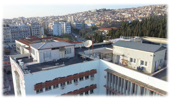
Figure 1.
Aerial view of the Laboratory of Atmospheric Physics (LAP) infrastructure, located on the rooftop of the School of Physics building (40.5° N, 22.9° E; 60 m).
For over a decade, the LAP maintained a dynamic and consistent engagement with the educational community through the organization of numerous annual visits by school groups of all levels. Each year, a significant number of students participate in these educational visits, which offer a unique opportunity to explore atmospheric sciences first-hand under the guidance of the laboratory’s experienced research staff. Through interactive tours and tailored presentations, students are introduced to key concepts of atmospheric monitoring and the broader role of science in tackling climate-related challenges. This long-standing outreach activity highlights LAP’s sustained commitment to scientific education and public engagement. The infrastructure supports a wide range of scientific, outreach, and educational activities related to atmospheric and climate studies. Figure 2 showcases key remote sensing instruments (e.g., Sun photometers, spectrometers, MAX-DOAS, FTIR, Brewer, and Lidar systems) at the LAP, each contributing to high-precision atmospheric monitoring and climate research.
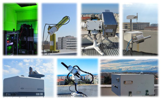
Figure 2.
Overview of key remote sensing instruments at the Laboratory of Atmospheric Physics (LAP) infrastructure (https://lapweb.physics.auth.gr/infrastructure-gr/#Infrastructure; accessed on 31 May 2025).
2. Educational Framework and Implementation Strategy
The structure and methodological approach developed by the LAP is designed to engage a diverse youth audience, with particular emphasis on secondary school students (ages 12–17) and targeted citizen communities. These groups represent highly motivated and dynamic segments of the younger population, ideally positioned to benefit from and contribute to educational initiatives. By reaching into both formal education systems and organized youth networks, LAP maximizes its outreach across a range of learning environments. A well-developed program is implemented based on the principles of experiential learning, combining theoretical instruction with practical, data-driven activities. The structured approach integrates remote sensing technologies, interactive tools, and real-world environmental data to enhance student engagement, critical thinking, and understanding of atmospheric processes and climate change. Students participate in hands-on learning experiences focused on using remote sensing data to explore key atmospheric phenomena such as aerosol transport, cloud dynamics, and greenhouse gas concentrations. Activities include guided laboratory visits and access to user-friendly tools and technical documentation, making complex data more accessible to non-specialist users. Scenario-based exercises will allow students to simulate climate events and analyze their impacts using actual data in a simplified, web-based interface.
2.1. Description of the Learning Material
LAP’s remote sensing-based climate education strategy centers on three core components, as illustrated in Figure 3: (a) Interactive Workshops, (b) Data-Driven Projects, and (c) Hands-On Experiments. Designed for secondary education, the program combines theoretical foundations with practical learning to deepen student commitment in climate and atmospheric science. It offers training modules, technical support, and research-based evaluations of teaching practices. Using open-access datasets and web-based tools, students explore real-world issues such as air quality, wildfire tracking, and pollution. The initiative enhances accessibility through interactive, cloud-based platforms and a digital resource repository, promoting active learning and reinforcing LAP’s commitment to innovative, remote sensing–driven climate education.
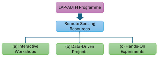
Figure 3.
Methodological framework of the LAP educational program.
2.2. Data Resources and Learning Material
The LAP actively utilizes advanced digital tools and infrastructures to provide seamless access to high-quality atmospheric and climate data, while contributing to the broader open science and educational ecosystem. A central element of this approach is the integration of structured and interoperable platforms that support environmental data access, discovery, and interactive visualization. LAP’s educational and citizen science activities are built upon reliable data repositories and services from major European Research Infrastructures (RIs), including the following: (i) Aerosol, Clouds and Trace Gases Research Infrastructure (ACTRIS; https://www.actris.eu/; accessed on 31 May 2025), (ii) European Space Agency (ESA Climate Office; https://climate.esa.int/en/data/; accessed on 31 May 2025), (iii) European Organization for the Exploitation of Meteorological Satellites Data Centre (EUMETSAT; https://user.eumetsat.int/data-access/data-centre/data; accessed on 31 May 2025), (iv) Copernicus environmental data and processing platform (WEkEO; https://wekeo.copernicus.eu/; accessed on 31 May 2025) and (v) Earth Science Data Systems (ESDS) Program (https://www.earthdata.nasa.gov/; accessed on 31 May 2025). These platforms offer authoritative ground-based and satellite-derived datasets on atmospheric composition and key climate indicators, forming the backbone of LAP’s educational resources and interactive learning experiences. The diagram, illustrated in Figure 4, highlights the connection between LAP and international data services mentioned above, through user-friendly interfaces for accessing atmospheric and climate datasets.
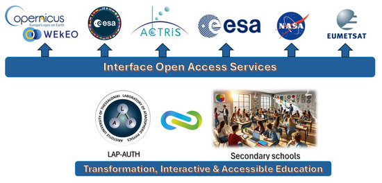
Figure 4.
Flowchart of the integration of open-access digital resources into the educational program developed by the Laboratory of Atmospheric Physics (LAP).
2.3. Expected Outcomes and Educational Impact
The program is designed to foster critical thinking, enhance scientific literacy, and help combat misinformation related to climate change and air quality. A key educational impact is the integration of research and education, enabling LAP to actively contribute to shaping a new generation of informed, climate-conscious citizens. Students become active participants in scientific exploration. These models are designed to be adaptable across different educational contexts and will incorporate simplified, online tools like those mentioned above, allowing students to engage directly with remote sensing data via intuitive, user-friendly interfaces. The use of scenario-based learning modules will enable students to simulate environmental phenomena to assess their impacts using actual satellite observations. This hands-on, data-driven approach strengthens their ability to interpret complex information and apply it in meaningful ways.
3. Discussion and Future Directions
Recognizing the urgent need to address the climate crisis, LAP is uniquely positioned to serve as a regional hub for advancing scientific knowledge and developing innovative solutions. The Laboratory is committed to transforming awareness into action—promoting climate resilience as a national priority and laying the groundwork for a healthier, more sustainable future. Looking ahead, we plan to expand student training programs and develop modular educational resources that can be adapted to different learning levels. A Climate Education Resource Hub is also under development, designed to curate lesson plans, data tools, and tutorial content based on LAP’s scientific assets. By incorporating hands-on training with real atmospheric data and open-access tools, LAP enables students to engage directly with the processes of environmental monitoring and analysis. This experiential learning approach enhances technical proficiency and cultivates essential skills such as data interpretation, critical thinking, and evidence-based decision-making which are crucial assets for the next generations.
Author Contributions
Conceptualization, K.M.; methodology, K.M. and K.G.; formal analysis, K.M., K.G. and C.T.; investigation, K.M. and C.T.; data curation, K.M., K.G. and C.T.; writing—original draft preparation, K.M.; supervision, D.B. All authors have read and agreed to the published version of the manuscript.
Funding
This research received no external funding.
Institutional Review Board Statement
Not applicable.
Informed Consent Statement
Not applicable.
Data Availability Statement
The innovative study utilizes high-quality, open-access Earth Observation and atmospheric composition datasets provided by Copernicus services (https://wekeo.copernicus.eu; accessed on 31 May 2025), ESA (https://dataspace.copernicus.eu; accessed on 31 May 2025) and EUMESAT (https://user.eumetsat.int/dashboard; accessed on 31 May 2025) satellite platforms and ground-based observational networks coordinated by ACTRIS (https://data.actris.eu/; accessed on 31 May 2025).
Acknowledgments
The authors would like to acknowledge the valuable contributions of all individuals involved in the development of the educational material, including both teachers and students, whose feedback and engagement were instrumental throughout the process.
Conflicts of Interest
The authors declare no conflicts of interest.
Abbreviations
The following abbreviations are used in this manuscript:
| ACTRIS | Aerosols, Clouds and Trace gases Research Infrastructure |
| ESA | European Space Agency |
| EUMETSAT | European Organisation for the Exploitation of Meteorological Satellites |
| LAP | Laboratory of Atmospheric Physics |
| AUTH | Aristotle University of Thessaloniki |
References
- IPCC. Climate Change 2023 Synthesis Report: Summary for Policymakers; IPCC: Geneva, Switzerland, 2023; pp. 1–34. [Google Scholar] [CrossRef]
- UNFCCC. United Nations Framework Convention on Climate Change. 1992. Available online: https://unfccc.int/sites/default/files/conveng.pdf (accessed on 10 May 2025).
- European Commission. Communication on The European Green Deal. 2019. Available online: https://commission.europa.eu/document/daef3e5c-a456-4fbb-a067-8f1cbe8d9c78_en (accessed on 10 May 2025).
- UNESCO. Getting Every School Climate-Ready: How Countries Are Integrating Climate Change Issues in Education; UNESCO: Paris, France, 2021; ED-2021/WS/35. [Google Scholar] [CrossRef]
- Amici, S.; Tesar, M. Building Skills for the Future: Teaching High School Students to Utilize Remote Sensing of Wildfires. Remote Sens. 2020, 12, 3635. [Google Scholar] [CrossRef]
- Cox, H.; Kelly, K.; Yetter, L. Using Remote Sensing and Geospatial Technology for Climate Change Education. J. Geosci. Educ. 2014, 62, 609–620. [Google Scholar] [CrossRef]
- Adaktylou, N. Remote Sensing as a Tool for Phenomenon-Based Teaching and Learning at the Elementary School Level: A Case Study for the Urban Heat Island Effect. Int. J. Educ. Methodol. 2020, 6, 517–531. [Google Scholar] [CrossRef]
- Voss, K.; Goetzke, R.; Hodam, H. Methods and potentials for using satellite image classification in school lessons. In Remote Sensing for Agriculture, Ecosystems, and Hydrology XIII; Neale, C.M.U., Maltese, A., Eds.; SPIE: Bellingham, WA, USA, 2011; Volume 8174, p. 81740K. [Google Scholar]
- Asimakopoulou, P.; Nastos, P.; Vassilakis, E.; Hatzaki, M.; Antonarakou, A. Earth Observation as a Facilitator of Climate Change Education in Schools: The Teachers’ Perspectives. Remote Sens. 2021, 13, 1587. [Google Scholar] [CrossRef]
Disclaimer/Publisher’s Note: The statements, opinions and data contained in all publications are solely those of the individual author(s) and contributor(s) and not of MDPI and/or the editor(s). MDPI and/or the editor(s) disclaim responsibility for any injury to people or property resulting from any ideas, methods, instructions or products referred to in the content. |
© 2025 by the authors. Licensee MDPI, Basel, Switzerland. This article is an open access article distributed under the terms and conditions of the Creative Commons Attribution (CC BY) license (https://creativecommons.org/licenses/by/4.0/).