Track by Track: Revealing Sauropod Turning and Lateralised Gait at the West Gold Hill Dinosaur Tracksite (Upper Jurassic, Bluff Sandstone, Colorado)
Abstract
1. Introduction
2. Location and Geology
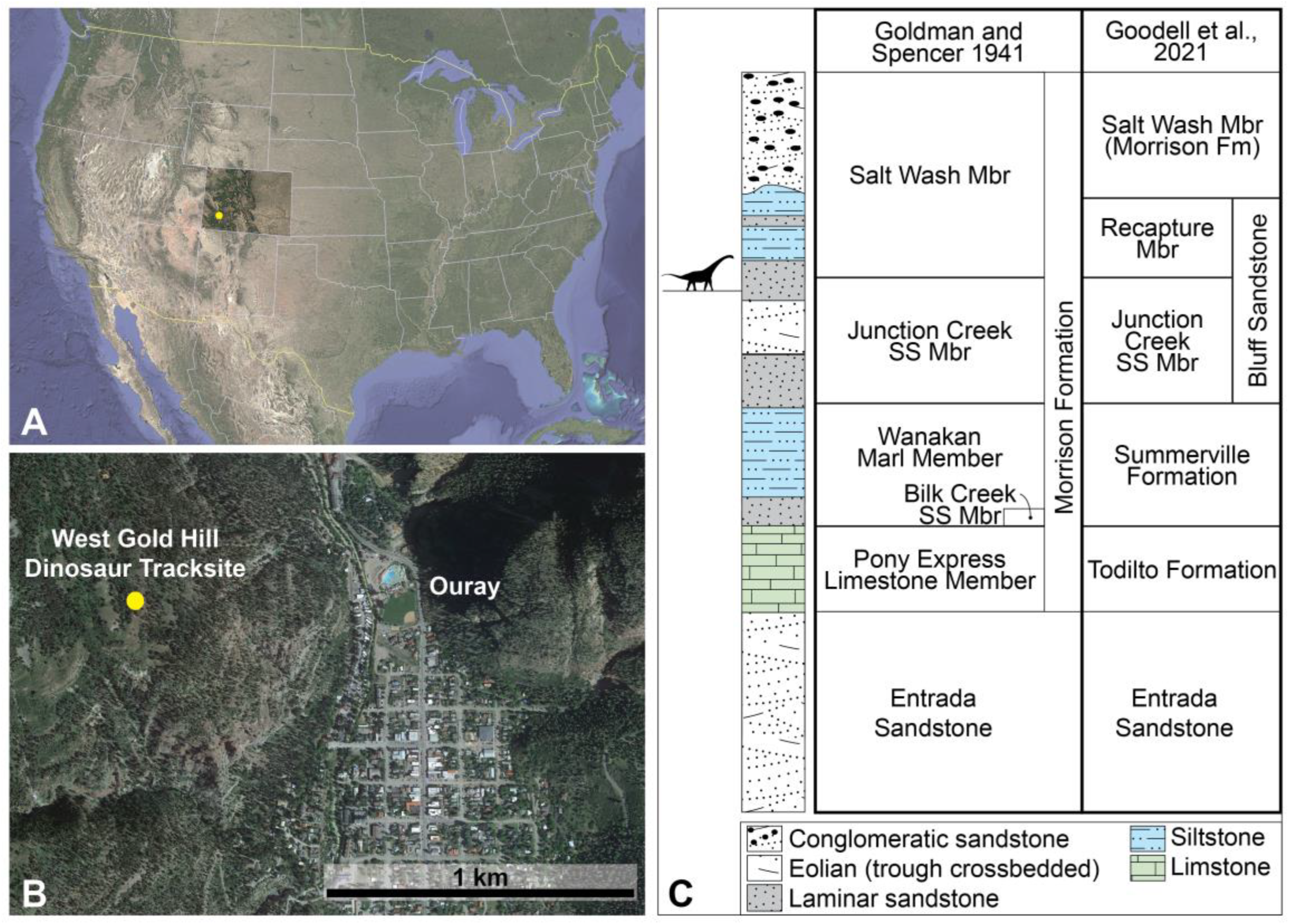
3. Materials and Methods
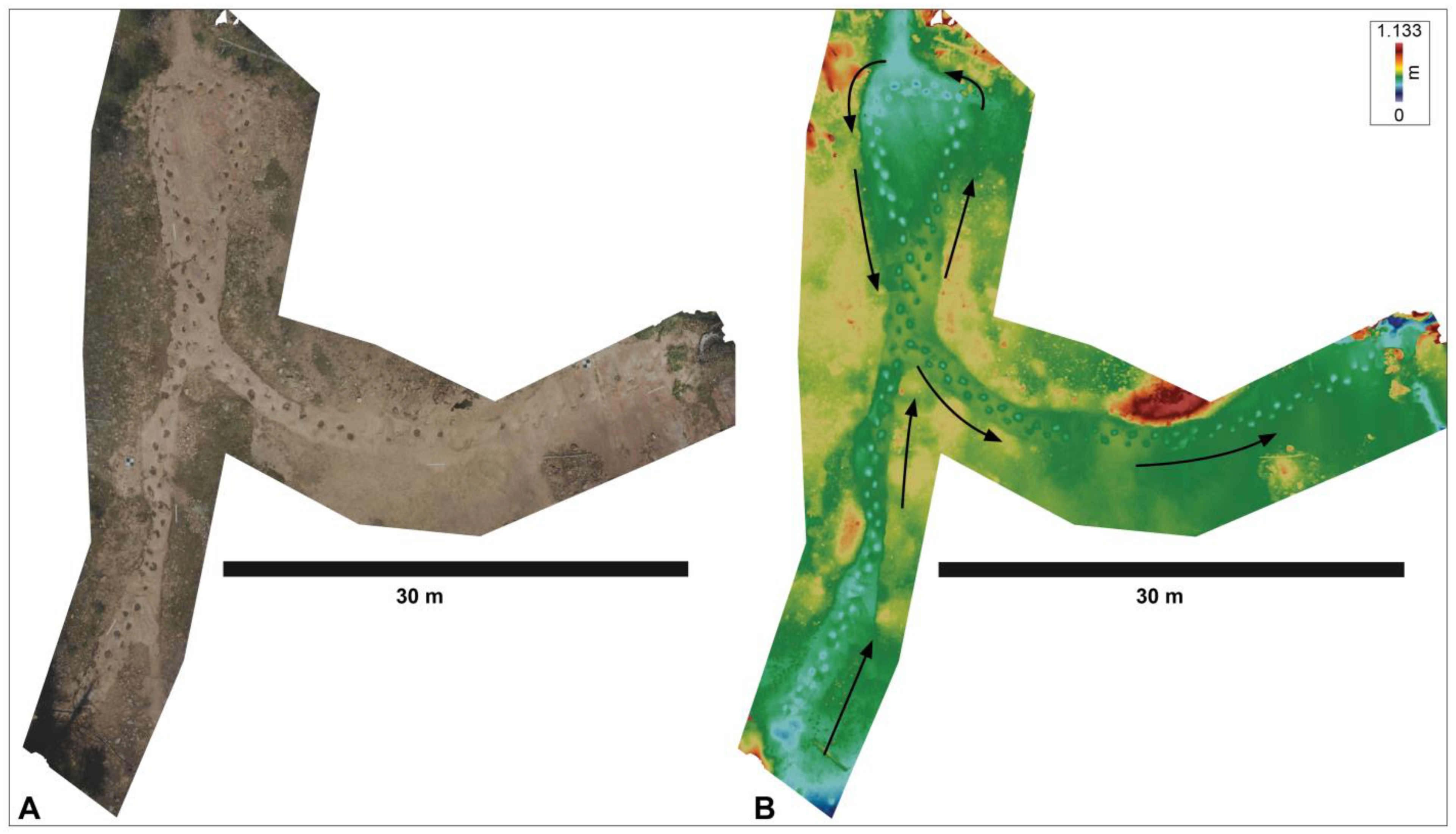
3.1. Digital Mapping of the Track Surface
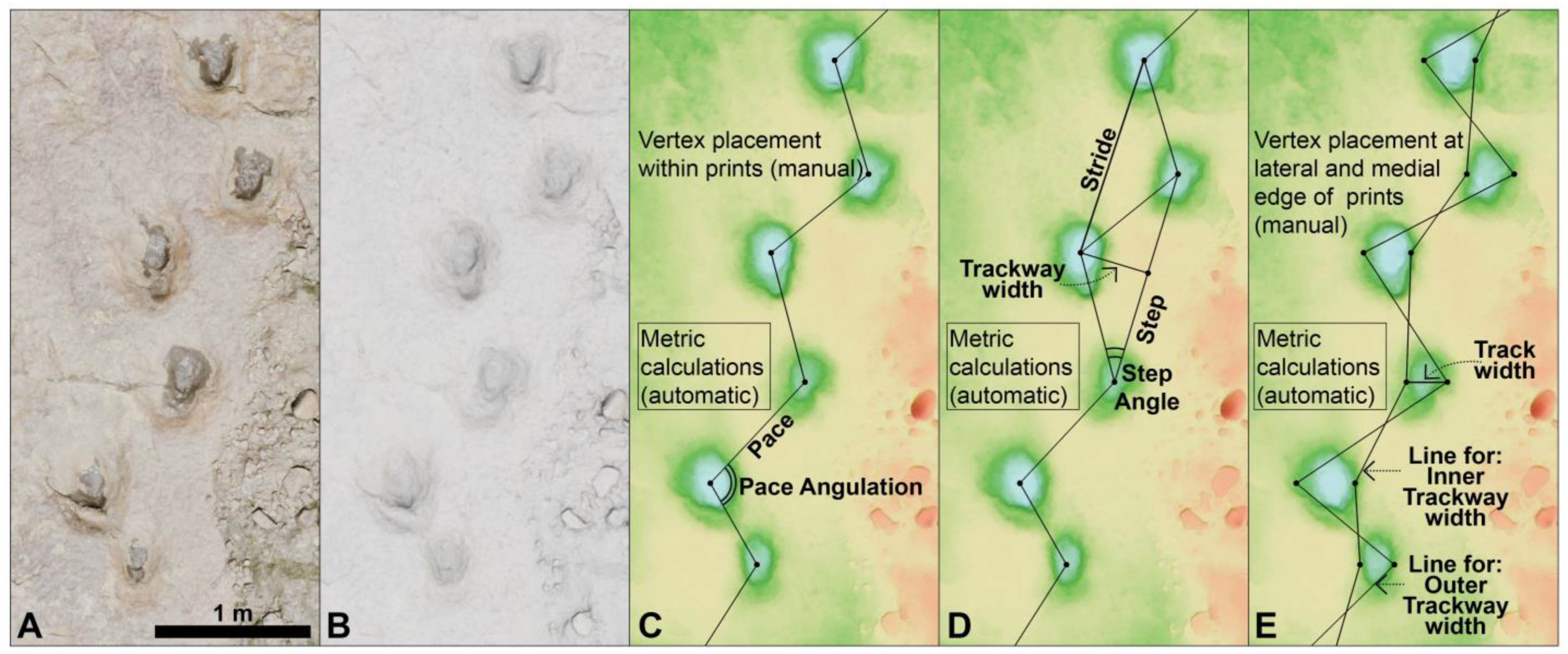
3.2. Digital Landmarking and Analysis
3.3. Trackway Parameter Calculations
3.4. Trackmaker Biometric Inferences
4. Results
4.1. Trackway Parameters
4.2. Trackmaker Biometrics
5. Discussion
5.1. Integrating Original Mapping with Continuous, Centreline Morphometrics
5.2. Resolution of Turning Data
5.3. Behavioural Inferences from Asymmetry Data
5.4. Trackmaker Attribution Challenges
Supplementary Materials
Author Contributions
Funding
Data Availability Statement
Acknowledgments
Conflicts of Interest
Abbreviations
| WGHDT | West Gold Hill Dinosaur Tracksite |
| HH | Hip Height |
| FL | Footprint Length |
| DL | Direct Length/distance between two footprints |
| TL | Trackway Length/distance between two footprints |
References
- Matthews, N.A.; Noble, T.A.; Breithaupt, B.H. Close-Range Photogrammetry for 3-D Ichnology: The Basics of Photogrammetric Ichnology. In Dinosaur Tracks: The Next Steps; Falkingham, P., Marty, D., Richter, A., Eds.; Indiana University Press: Bloomington, IN, USA, 2016; pp. 29–55. [Google Scholar]
- Salisbury, S.W.; Romilio, A.; Herne, M.C.; Tucker, R.T.; Nair, J.P. The Dinosaurian Ichnofauna of the Lower Cretaceous (Valanginian–Barremian) Broome Sandstone of the Walmadany Area (James Price Point), Dampier Peninsula, Western Australia. J. Vertebr. Paleontol. 2016, 36, 1–152. [Google Scholar] [CrossRef]
- Petti, F.M.; Petruzzelli, M.; Conti, J.; Spalluto, L.; Wagensommer, A.; Lamendola, M.; Francioso, R.; Montrone, G.; Sabato, L.; Tropeano, M. The use of aerial and close-range photogrammetry in the study of dinosaur tracksites; Lower Cretaceous (upper Aptian/lower Albian) Molfetta ichnosite (Apulia, southern Italy). Palaeontol. Electron. 2018, 21, 1–18. [Google Scholar] [CrossRef]
- Murphey, P.C.; Matthews, N.A.; Breithaupt, B.H.; Lockley, M.G. Thirty-six years of tracking and mapping at Dinosaur Ridge, Morrison, Colorado, USA. Vertebr. Paleontol. A Tribut. Martin Lockley New Mex. Mus. Nat. Hist. Sci. Bull. 2024, 95, 327–347. [Google Scholar]
- Romilio, A.; Hacker, J.M.; Zlot, R.; Poropat, G.; Bosse, M.; Salisbury, S.W. A multidisciplinary approach to digital mapping of dinosaurian tracksites in the Lower Cretaceous (Valanginian-Barremian) Broome Sandstone of the Dampier Peninsula, Western Australia. PeerJ 2017, 5, e3013. [Google Scholar] [CrossRef]
- Xing, L.D.; Lockley, M.G.; Romilio, A.; Klein, H.; Zhang, J.Q.; Chen, H.Y.; Zhang, J.J.; Burns, M.E.; Wang, X.L. Diverse sauropod-theropod dominated track assemblage from the Lower Cretaceous Dasheng Group of Eastern China: Testing the use of drones in footprint documentation. Cretac. Res. 2018, 84, 588–599. [Google Scholar] [CrossRef]
- Yang, Q.; Xing, L.; Du, F.; Chen, Q.; Klein, H.; Romilio, A.; Jin, Y.; Liu, L.; Qi, J.; Zhao, M.; et al. A new sauropod-dominated tracksite from the Lower Cretaceous in central Ningxia, northwestern China, and the implications on palaeoenvironments. Swiss J. Palaeontol. 2025, 144, 35. [Google Scholar] [CrossRef]
- Goodell, Z.; Lockley, M.G.; Lucas, S.G.; Schumacher, B.A.; Smith, J.A.; Trujillo, R.; Xing, L. A High-Altitude Sauropod Trackway Site in the Jurassic of Colorado: The Longest Known Consecutive Footprint Sequence Reveals Evidence of Sharp Turning Behavior. New Mex. Mus. Nat. Hist. Sci. Bull. 2021, 82, 101–112. [Google Scholar]
- Lockley, M.G.; Xing, L.; Kim, K.S.; Meyer, C.A. Tortuous trackways: Evidence and implications of deviations, turns and changes in direction by dinosaurian trackmakers. Hist. Biol. 2021, 33, 3326–3339. [Google Scholar] [CrossRef]
- Romilio, A.; Shao, C. Analysing trackway-based speed calculations to infer dinosaur locomotive capabilities and behaviours. Hist. Biol. 2024, 36, 2244–2253. [Google Scholar] [CrossRef]
- Romilio, A.; Park, R.; Nichols, W.; Jackson, O. Dinosaur footprints from the Lower Jurassic (Hettangian–Sinemurian) Precipice Sandstone of the Callide Basin, Queensland, Australia. Hist. Biol. 2025, 1–12. [Google Scholar] [CrossRef]
- O’Sullivan, R.B. Jurassic Wanakah and Morrison Formations in the Telluride-Ouray-Western Black Canyon Area of Southwestern Colorado; US Government Printing Office: Washington, DC, USA, 1992; Volume 1927, pp. 1–24.
- Burbank, W.S.; Luedke, R.G. Geology of the Ouray Quadrangle. In U.S. Geological Survey Geological Quadrangle; U.S. Geological Survey: Washington, DC, USA, 1962; Volume 152. [Google Scholar]
- Burbank, W.S.; Luedke, R.G. Geology and Ore Deposits of the Uncom-Pahgre (Ouray) Mining District, Southwestern Colorado; U.S. Geological Survey: Reston, VA, USA, 2008; Volume 1753, p. 107.
- Kirkland, J.I.; DeBlieux, D.D.; Hunt-Foster, R.K.; Foster, J.R.; Trujillo, K.C.; Finzel, E. The Morrison Formation and its bounding strata on the western side of the Blanding Basin, San Juan County, Utah. Geol. Intermt. West Utah Geol. Assoc. 2020, 7, 37–195. [Google Scholar] [CrossRef]
- Kelley, V.C. Geology of Ouray and environs. In New Mexico Geological Society Guidebook; New Mexico Geological Society: Socorro, NM, USA, 1957; Volume 8, pp. 203–207. [Google Scholar]
- Lucas, S.G.; Heckert, A.B. Mesozoic stratigraphy at Durango, Colorado. In New Mexico Geological Society, 56th Field Conference Guidebook, Geology of the Chama Basin, NM, USA, 21–24 September 2005; Lucas, S.G., Zeigler, K.E., Lueth, V.W., Owen, D.E., Eds.; New Mexico Museum of Natural History and Science: Albuquerque, NM, USA, 2005; pp. 160–169. [Google Scholar]
- Lucas, S.G. Triassic-Jurassic stratigraphy in southwestern Colorado. In New Mexico Geological Society, Guidebook; New Mexico Geological Society: Socorro, NM, USA, 2017; Volume 68, pp. 149–158. [Google Scholar]
- Goldman, M.I.; Spencer, A.C. Correlation of Cross’ La Plata Sandstone, southwestern Colorado. Am. Assoc. Pet. Geol. Bull. 1941, 25, 1745–1767. [Google Scholar]
- Falkingham, P.L.; Bates, K.T.; Avanzini, M.; Bennett, M.; Bordy, E.; Breithaupt, B.H.; Castanera, D.; Citton, P.; Díaz-Martínez, I.; Farlow, J.O.; et al. A standard protocol for documenting modern and fossil ichnological data. Paleontology 2018, 61, 469–480. [Google Scholar] [CrossRef]
- Romilio, A. An Instructional Guide to Visualising Dinosaur Tracks; Amazon: Columbia, SC, USA, 2020. [Google Scholar]
- Lallensack, J.N.; Buchwitz, M.; Romilio, A. Photogrammetry in ichnology: 3D model generation, visualisation, and data extraction. J. Paleontol. Tech. 2022, 22, 1–18. [Google Scholar] [CrossRef]
- Szeliski, R. Computer Vision: Algorithms and Applications, 1st ed.; Springer Nature: London, UK, 2010; p. 957. [Google Scholar]
- Westoby, M.J.; Brasington, J.; Glasser, N.F.; Hambrey, M.J.; Reynolds, J.M. ‘Structure-from-Motion’ photogrammetry: A low-cost, effective tool for geoscience applications. Geomorphology 2012, 179, 300–314. [Google Scholar] [CrossRef]
- Falkingham, P.L. Acquisition of high resolution 3D models using free, open-source, photogrammetric software. Palaeontol. Electron. 2012, 15, 1–15. [Google Scholar]
- Cignoni, P.; Callieri, M.; Corsini, M.; Dellepiane, M.; Ganovelli, F.; Ranzuglia, G. MeshLab: An open-source mesh processing tool. In Proceedings of the Sixth Eurographics Italian Chapter Conference, Salerno, Italy, 2–4 July 2008; pp. 129–136. [Google Scholar]
- Ahrens, J.; Geveci, B.; Law, C. 36—ParaView: An End-User Tool for Large-Data Visualization. In Visualization Handbook; Hansen, C.D., Johnson, C.R., Eds.; Butterworth-Heinemann: Burlington, ON, Canada, 2005; pp. 717–731. [Google Scholar]
- Romilio, A.; Dick, R.; Skinner, H.; Millar, J. Uncovering hidden footprints: Revision of the Lower Jurassic (Sinemurian) Razorback Beds—Home to Australia’s earliest reported dinosaur trackway. Hist. Biol. 2025, 37, 596–603. [Google Scholar] [CrossRef]
- Romano, M.; Whyte, M.A.; Jackson, S.J. Trackway ratio: A new look at trackway gauge in the analysis of quadrupedal dinosaur trackways and its implications for ichnotaxonomy. Ichnos 2007, 14, 257–270. [Google Scholar] [CrossRef]
- Benhamou, S. How to reliably estimate the tortuosity of an animal’s path: Straightness, sinuosity, or fractal dimension? J. Theor. Biol. 2004, 229, 209–220. [Google Scholar] [CrossRef]
- Nams, V.O. Using animal movement paths to measure response to spatial scale. Oecologia 2005, 143, 179–188. [Google Scholar] [CrossRef] [PubMed]
- Bustos, D.; Jakeway, J.; Urban, T.M.; Holliday, V.T.; Fenerty, B.; Raichlen, D.A.; Budka, M.; Reynolds, S.C.; Allen, B.D.; Love, D.W.; et al. Footprints preserve terminal Pleistocene hunt? Human-sloth interactions in North America. Sci. Adv. 2018, 4, eaar7621. [Google Scholar] [CrossRef]
- Foster, J. Relative abundances of the Sauropoda (Dinosauria, Saurischia) of the Morrison Formation and implications for Late Jurassic paleoecology of North America. Mesa Southwest Mus. Bull. 2001, 8, 47–60. [Google Scholar]
- Henderson, D.M. Burly gaits: Centers of mass, stability, and the trackways of sauropod dinosaurs. J. Vertebr. Paleontol. 2006, 26, 907–921. [Google Scholar] [CrossRef]
- Diedrich, C.G. Upper Jurassic tidal flat megatracksites of Germany—Coastal dinosaur migration highways between European islands, and a review of the dinosaur footprints. Senckenberg. Lethaea 2011, 91, 129–155. [Google Scholar] [CrossRef]
- Castanera, D.; Pascual, C.; Canudo, J.I.; Hernández, N.; Barco, J.L. Ethological variations in gauge in sauropod trackways from the Berriasian of Spain. Lethaia 2012, 45, 476–489. [Google Scholar] [CrossRef]
- Marty, D. Sedimentology, taphonomy, and ichnology of Late Jurassic dinosaur tracks from the Jura carbonate platform (Chevenez—Combe Ronde tracksite, NW Switzerland): Insights into the tidal-flat palaeoenvironment and dinosaur diversity, locomotion, and palaeoecology. GeoFocus 2008, 21, 1–278. [Google Scholar]
- Alexander, R.M. Estimates of speeds of dinosaurs. Nature 1976, 261, 129–130. [Google Scholar] [CrossRef]
- Lockley, M.G.; Hunt, A.P.; Moratalla, J.J.; Matsukawa, M. Limping dinosaurs? Trackway evidence for abnormal gaits. Ichnos 1994, 3, 193–202. [Google Scholar] [CrossRef]
- Xing, L.D.; Lockley, M.G.; Marty, D.; He, J.J.; Hu, X.F.; Dai, H.; Matsukawa, M.; Peng, G.Z.; Yong, Y.; Klein, H. Wide-gauge sauropod trackways from the early Jurassic of Sichuan, China: The oldest sauropod trackways from Asia. Eclogae Geol. Helv. 2016, 109, 415–428. [Google Scholar]
- Xing, L.D.; Marty, D.; Wang, K.B.; Lockley, M.G.; Chen, S.Q.; Xu, X.; Liu, Y.Q.; Kuang, H.W.; Zhang, J.P.; Ran, H.; et al. An unusual sauropod turning trackway from the early cretaceous of Shandong province, China. Palaeogeogr. Palaeoclim. Palaeoecol. 2015, 437, 74–84. [Google Scholar] [CrossRef]
- Lockley, M.G. Dinosaur tracks. Ichnos 1992, 2, 79–83. [Google Scholar] [CrossRef]
- Moratalla, J.J. Sauropod tracks of the Cameros Basin (Spain): Identification, trackway patterns and changes over the Jurassic-Cretaceous. Geobios 2009, 42, 797–811. [Google Scholar] [CrossRef]
- Myers, T.S.; Fiorillo, A.R. Evidence for gregarious behavior and age segregation in sauropod dinosaurs. Palaeogeogr. Palaeoclim. Palaeoecol. 2009, 274, 96–104. [Google Scholar] [CrossRef]
- dos Santos, V.F.; Moratalla, J.J.; Royo-Torres, R. New sauropod trackways from the Middle Jurassic of Portugal. Acta Palaeontol. Pol. 2009, 54, 409–422. [Google Scholar] [CrossRef]
- Meyer, C.A. The hitch-hikers guide to the Late Jurassic and Early Cretaceous-Dinosaur tracks from the Swiss and French Jura Mountains in a sequence stratigraphic context. In Dinosaur Track Symposia 2011 Obernkirchen, Abstracts Volume; Richter, A., Hübner, T., van der Lubbe, T., Eds.; Universitätsverlag Göttingen: Göttingen, Germany, 2012; p. 43. [Google Scholar]
- Vildoso, C.A.; Calvo, J.O.; Porfiri, J.D. The highest sauropod tracksite in the World, Lower Cretaceous, Peru. In Dinosaur Track Symposia 2011 Obernkirchen, Abstracts Volume; Richter, A., Hübner, T., van der Lubbe, T., Eds.; Universitäts-Verlag Göttingen: Göttingen, Germany, 2011; p. 35. [Google Scholar]
- Kim, J.Y.; Lockley, M.G. New sauropod tracks (Brontopodus pentadactylus ichnosp. nov.) from the Early Cretaceous Haman Formation of Jinju area, Korea: Implications for sauropods manus morphology. Ichnos 2012, 19, 84–92. [Google Scholar] [CrossRef]
- Falkingham, P.L.; Bates, K.T.; Margetts, L.; Manning, P.L. Simulating sauropod manus-only trackway formation using finite-element analysis. Biol. Lett. 2011, 7, 142–145. [Google Scholar] [CrossRef]
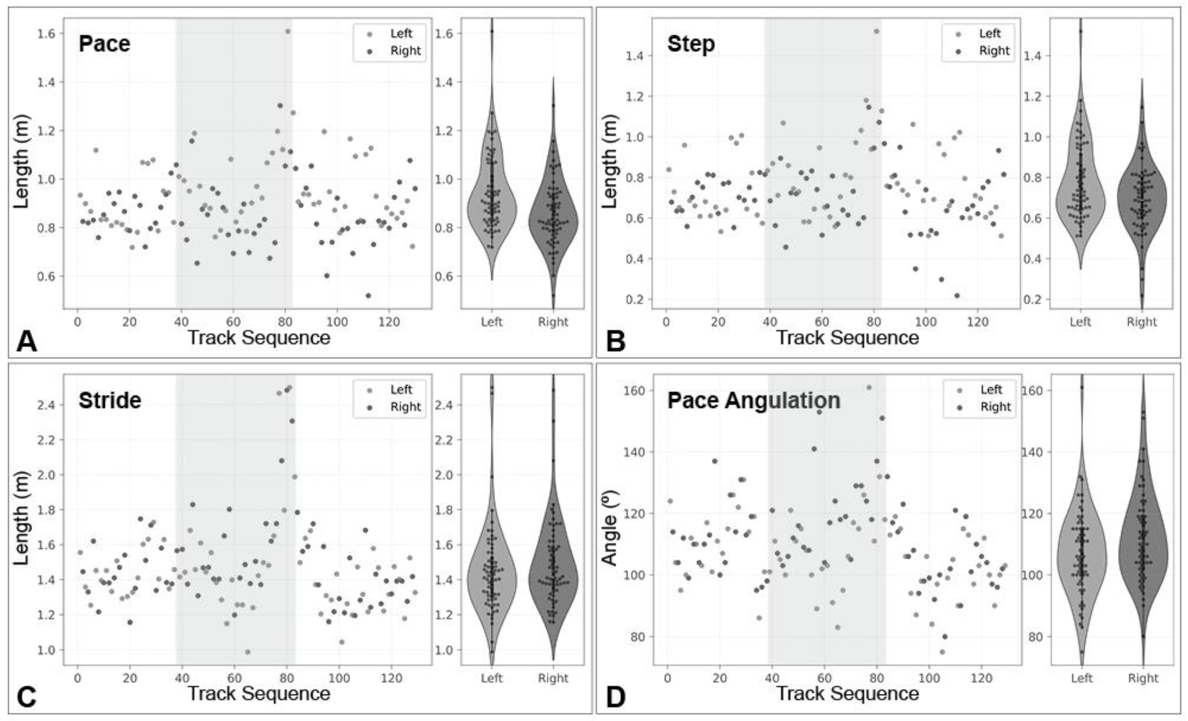
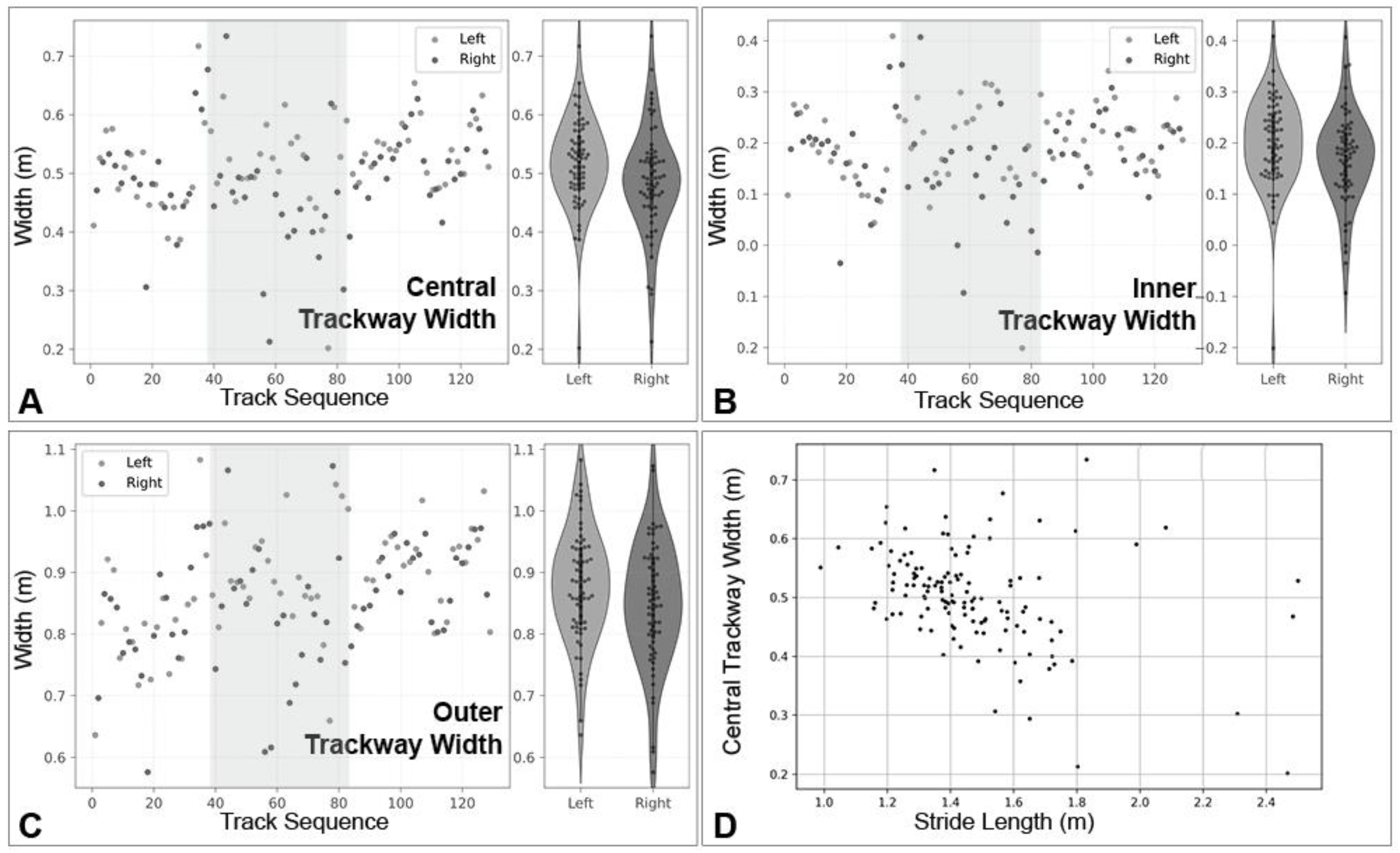

| Pace (m) | Step (m) | Stride (m) | Pace Ang (°) | Step Angle (°) | Trackway Width Central (m) | Trackway Width Inner (m) | Trackway Width Outer (m) |
|---|---|---|---|---|---|---|---|
| Mean: 0.901 | 0.737 | 1.470 | 109 | 35 | 0.502 | 0.185 | 0.863 |
| Median: 0.881 | 0.712 | 1.416 | 108 | 35 | 0.501 | 0.190 | 0.863 |
| (SD 0.151) | (SD 0.180) | (SD 0.251) | (SD 14) | (SD 8) | (SD 0.084) | (SD 0.089) | (SD 0.095) |
| Min–Max: 0.520–1.609 | 0.218–1.520 | 0.988–2.500 | 75–161 | 10–65 | 0.202–0.734 | −0.201–0.409 | 0.576–1.083 |
| L2R: 0.944 | 0.779 | 1.450 | 107 | 34 | 0.517 | 0.200 | 0.878 |
| (SD 0.155) | (SD 0.189) | (SD 0.245) | (SD 14) | (SD 8) | (SD 0.076) | (SD 0.088) | (SD 0.090) |
| R2L: 0.858 | 0.695 | 1.489 | 112 | 36 | 0.487 | 0.169 | 0.848 |
| (SD 0.135) | (SD 0.163) | (SD 0.249) | (SD 14) | (SD 9) | (SD 0.090) | (SD 0.090) | (SD 0.099) |
| t: 3.358 | 2.708 | −0.922 | −2.070 | −0.944 | 2.043 | 1.940 | 1.799 |
| p: 0.001 | 0.008 | 0.358 | 0.040 | 0.347 | 0.043 | 0.055 | 0.074 |
| Gauge (Traditional) | Gauge (Incremental) | Pes Width (m) |
|---|---|---|
| Mean: 32.6 | 40.1 | 0.343 |
| Median: 32.2 | 39.5 | 0.333 |
| (SD 3.9) | (SD 8.3) | (SD 0.064) |
| Min–Max: 25.6–48.3 | 23.1–71.0 | 0.195–0.495 |
| L2R: 32.0 | 39.0 | |
| (SD 3.5) | (SD 6.9) | |
| R2L: 33.3 | 41.3 | |
| (SD 4.3) | (SD 9.5) | |
| t: −1.8 | −1.6 | |
| p: 0.069 | 0.112 |
Disclaimer/Publisher’s Note: The statements, opinions and data contained in all publications are solely those of the individual author(s) and contributor(s) and not of MDPI and/or the editor(s). MDPI and/or the editor(s) disclaim responsibility for any injury to people or property resulting from any ideas, methods, instructions or products referred to in the content. |
© 2025 by the authors. Licensee MDPI, Basel, Switzerland. This article is an open access article distributed under the terms and conditions of the Creative Commons Attribution (CC BY) license (https://creativecommons.org/licenses/by/4.0/).
Share and Cite
Romilio, A.; Murphey, P.C.; Matthews, N.A.; Schumacher, B.A.; Murphey, L.D.; Toscanini, M.; Boyce, P.; Fitzner, Z. Track by Track: Revealing Sauropod Turning and Lateralised Gait at the West Gold Hill Dinosaur Tracksite (Upper Jurassic, Bluff Sandstone, Colorado). Geomatics 2025, 5, 67. https://doi.org/10.3390/geomatics5040067
Romilio A, Murphey PC, Matthews NA, Schumacher BA, Murphey LD, Toscanini M, Boyce P, Fitzner Z. Track by Track: Revealing Sauropod Turning and Lateralised Gait at the West Gold Hill Dinosaur Tracksite (Upper Jurassic, Bluff Sandstone, Colorado). Geomatics. 2025; 5(4):67. https://doi.org/10.3390/geomatics5040067
Chicago/Turabian StyleRomilio, Anthony, Paul C. Murphey, Neffra A. Matthews, Bruce A. Schumacher, Lance D. Murphey, Marcello Toscanini, Parker Boyce, and Zach Fitzner. 2025. "Track by Track: Revealing Sauropod Turning and Lateralised Gait at the West Gold Hill Dinosaur Tracksite (Upper Jurassic, Bluff Sandstone, Colorado)" Geomatics 5, no. 4: 67. https://doi.org/10.3390/geomatics5040067
APA StyleRomilio, A., Murphey, P. C., Matthews, N. A., Schumacher, B. A., Murphey, L. D., Toscanini, M., Boyce, P., & Fitzner, Z. (2025). Track by Track: Revealing Sauropod Turning and Lateralised Gait at the West Gold Hill Dinosaur Tracksite (Upper Jurassic, Bluff Sandstone, Colorado). Geomatics, 5(4), 67. https://doi.org/10.3390/geomatics5040067


