Abstract
Effective management of water resources is crucial for sustainable development in any region. When considering computer-aided analysis for resource management, geospatial technology, i.e., the use of remote sensing (RS) combined with Geographic Information Systems (GIS) proves to be highly valuable. Geospatial technology is more cost-effective and requires less labor compared to ground-based surveys, making it highly suitable for a wide range of agricultural applications. Effectively utilizing the timely, accurate, and objective data provided by RS technologies presents a crucial challenge in the field of water resource management. Satellite-based RS measurements offer consistent information on agricultural and hydrological conditions across extensive land areas. In this study, we carried out a detailed analysis focused on addressing agricultural water management issues in India through the application of RS and GIS technologies. Adhering to the Preferred Reporting Items for Systematic Reviews and Meta-Analysis (PRISMA) guidelines, we systematically reviewed published research articles, providing a comprehensive and detailed analysis. This study aims to explore the use of RS and GIS technologies in crucial agricultural water management practices with the goal of enhancing their effectiveness and efficiency. This study primarily examines the current use of geospatial technology in Indian agricultural water management and sustainability. We revealed that considerable research has primarily used multispectral Landsat series data. Cutting-edge technologies like Sentinel, Unmanned Aerial Vehicles (UAVs), and hyperspectral technology have not been fully investigated for the assessment and monitoring of water resources. Integrating RS and GIS allows for consistent agricultural monitoring, offering valuable recommendations for effective management.
1. Introduction
Water, a crucial natural resource, is facing growing strain globally. This is attributed to various factors, such as rising populations; excessive agricultural irrigation leading to overuse and salinization; population growth in arid regions with limited water supply; very high pollution from urban areas, agriculture, and industry; increased human and industrial demand; and impacts of climate change. Moreover, surface water resources suffer from irregularity, scarcity, and unequal distribution [1]. In order to tackle the expected impacts of climate change on water and agriculture, especially while fulfilling diverse and competitive water needs, it is essential to implement smart water management approaches [2]. By relying on scientific evidence, agricultural water management can play a vital role in minimizing unsustainable water usage. It aids in improving water resilience and facilitates adaptation to climate change challenges [3]. Crop water stress disrupts essential physiological processes, emphasizing the importance of efficient water management to maintain equilibrium in agronomy, hydrology, and climatology. This is especially critical in areas where irrigation is indispensable for achieving the desired crop quality and yield. To enhance irrigation management and scheduling, it is essential to have a precise understanding of the quantity and timing of the water supply, which can be assessed through an accurate spatial evaluation of plant water stress [4,5]. Efficient agricultural water management practices are essential to expand irrigation coverage in India. Effectively managing water resources poses a significant challenge for countries like India. Developing water resources necessitates tackling vital aspects such as storage, conservation, and subsequent utilization [6].
Mismanagement of the water supply and other natural resources makes drought, a serious natural calamity, much worse [7]. However, rainfall patterns vary significantly in terms of both location and timing across the country. Intense, concentrated rainfall in a short period leads to devastating floods, while delayed and sparse rainfall results in drought conditions [8]. Considering the potential adverse effects of global climate change on water resources, the risks to food security, human resource employment, and power security are increasingly pronounced [9,10]. Therefore, it is imperative to assess future water availability at various spatial and temporal scales to effectively address these challenges. Agricultural drought significantly impacts the economies of agrarian nations such as India, where over 68% of the population relies on agriculture [11]. Approximately 16% of India’s total land area is prone to drought, affecting around 50 million people annually [12,13]. An effectively developed mitigation and preparedness strategy is essential for decision makers to mitigate the impact of drought. Therefore, monitoring the onset, duration, intensity, and extent of drought has become crucial in managing its adverse effects on agricultural production [14,15]. India experienced devastating famines due to droughts in the last century [7]. Additionally, the unsustainable depletion of groundwater, crucial for irrigation, is anticipated to worsen agricultural challenges amid climate change, severely disrupting routine farming activities [16].
The crop evapotranspiration (ET) phenomenon is pivotal in the exchange of energy among crops, soil, water, and the atmosphere, and is crucial in studies related to energy exchange and water resource management [17,18]. Traditional methods have limitations in offering a wide-ranging spatial distribution of ET across large areas. However, advancements in satellite remote sensing techniques based on energy balance algorithms have enhanced the ability to map ET at a finer scale [19]. Efficient irrigation scheduling is crucial in the cultivation of different crops to prevent water wastage. In the past, different empirical equations and lysimeters were used to estimate crop ET. However, these methods were limited as they were point-based and could not be applied at a regional scale. To conserve water, it is essential to adopt new technologies for accurate monitoring of irrigation needs across large areas. Advanced geospatial techniques offer a solution by enabling regional estimation of crop water requirements in a shorter time, overcoming the limitations of traditional methods [9]. This helps farmers optimize irrigation schedules, preventing both overwatering and water scarcity, which directly impacts crop yield and quality. Runoff estimation in agricultural water management is vital for efficient water use. Understanding runoff patterns aids in erosion control, preserving soil fertility and structure. Proper estimation supports strategic crop selection, ensuring that farmers choose crops suited to local water availability, leading to sustainable agricultural practices [20]. Additionally, runoff estimation assists in managing water resources effectively, enabling the construction of reservoirs and facilitating the overall planning of irrigation systems. The use of satellite imageries to map natural resources, such as water bodies, has become increasingly significant. Water bodies are subject to intense utilization, necessitating regular monitoring for sustainable management. Identifying and mapping water bodies is essential for various purposes, including accurate surface water estimation and ensuring their sustainable use [21].
Water scarcity and climate change intensify the vulnerability of rainfed agriculture, impacting food production [22]. Soil moisture deficit significantly impacts agricultural productivity and hydrological processes [23]. To tackle these challenges, rainwater harvesting emerges as a vital solution. Food security requires a consistent supply of water, especially in areas with high population density. This can be achieved by capturing rainwater to combine surface and groundwater [24,25]. Rainwater harvesting not only stabilizes agricultural output but also enhances productivity and aids in restoring degraded lands. In India, both agricultural and domestic sectors are increasingly dependent on groundwater, leading to the depletion of this vital resource [26,27,28]. Rainwater harvesting stands out as a premier solution for enhancing both surface and groundwater resources [29,30,31]. In addition to the different traditional methods, geospatial technologies like RS and GIS have recently become important resources for acquiring spatio-temporal meteorological and crop status information [4,32]. RS data significantly enhance monitoring efforts by offering timely, comprehensive, cost-effective, and repetitive insights into the Earth’s surface. The acquisition of precise spatio-temporal meteorological and crop data is indispensable for precise analysis, forecasting, and agricultural planning. It plays a vital role in making informed decisions concerning irrigation scheduling, crop stress management, disaster readiness, and the preservation of natural resources and ecosystems in diverse regions [5]. The overarching objective of sustainable agriculture is to achieve a harmonious balance between available land resources and crop requirements, with a strong emphasis on optimizing resource usage to ensure sustained productivity over an extended period. Although traditional methods of gathering weather and crop growth data are reliable, they come with the drawback of being labor-intensive and time-consuming [23]. In such circumstances, geospatial technology, specifically RS and GIS, proves highly effective for gathering and managing extensive spatio-temporal data through satellite data, digital maps, and simulation models [9]. Because of its ability to provide data quickly and repeatedly, this technology has many benefits. It facilitates speedy analysis and the creation of useful information for planners and decision makers [33].
This study investigates innovative methods for identifying agricultural water management challenges to provide a precise assessment of the research background. It explores existing remote sensing datasets, methodological approaches, and GIS applications. The systematic literature review, conducted following Preferred Reporting Items for Systematic Reviews and Meta-Analysis (PRISMA) guidelines, ensures a thorough overview of the subject matter.
2. Research Method and Literature Search
Systematic Literature Review
In order to comply with the PRISMA criteria, we used a rigorous systematic literature review technique in this review paper. Our primary objective was to explore research studies pertaining to the integration of RS and GIS technologies in the context of agricultural water management. The PRISMA framework consists of four distinct stages—identification, screening, eligibility, and inclusion [5]. Three research questions are the primary source of this review article: (1) What specific agricultural water management challenges in India are addressed through geospatial technology? (2) Which primary RS datasets and tools are utilized to analyze issues related to agricultural water management? (3) What is the progress and future scope of geospatial technology to manage agricultural water management in India? We conducted a comprehensive literature search by exploring different databases, like Web of Science, Science Direct, MDPI, Springer, Scopus, and Google Scholar. Our search focused on specific keywords like “evapotranspiration estimation”, “water productivity estimation”, “drought management”, “runoff estimation”, “water resource mapping”, “waterlogged areas mapping”, “rainwater harvesting”, “soil moisture estimation”. We specifically identified these keywords in the titles, abstracts, and keywords of the articles. Furthermore, our focus was specifically on research articles published in the English language concerning India. As a result, we excluded papers published in languages other than English, review articles, preprints, chapters, and master’s and doctorate dissertations/theses from our analysis. In adherence to the PRISMA guidelines, a total of 60 research articles were identified and chosen, a process outlined in the form of the flowchart depicted in Figure 1. In the process of selection, we applied exclusion criteria similar to those utilized in recent review studies [5,34,35,36].
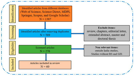
Figure 1.
Flowchart of methodology adopted for selection of articles for review considering PRISMA guidelines.
The notable increase in published research concerning the utilization of geospatial technology in agricultural water management in India signifies the achievement of a distinct level of expertise in this domain. As depicted in Figure 2, this trend emphasizes significant advancements in geospatial technology, including the accessibility of high-resolution satellite datasets. These developments highlight the maturation of geospatial technology applications in the realm of agricultural water management, underscoring the depth of knowledge and technological progress within the country.
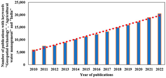
Figure 2.
Number of publications with keywords “Geospatial technology”, “Agricultural water management” and “India” from the year 2010 to 2022 as per Google Scholar search results. The red dots are the data points over the years.
Different remote sensing-based indices used based on stress in plants, soil moisture, evaporation, precipitation, temperature, and water bodies are presented in Table 1. The data and products identified in this review useful for agricultural water management are presented in Table 2.

Table 1.
List of the different remote sensing-based indices used in this review based on stress in plants, soil moisture, evaporation, precipitation, temperature, and water bodies.
Table 2.
List of the different remote sensing-based sensors and products identified in this review for agricultural water management.
3. Results
The selected studies were classified into different categories, namely, evapotranspiration (ET), irrigation water requirement, and water productivity estimation; drought assessment and monitoring; runoff estimation from agriculture watersheds; water body and waterlogged area mapping; identification of suitable sites for groundwater recharge and rainwater harvesting; and soil moisture estimation.
3.1. Evapotranspiration (ET), Irrigation Water Requirement, and Water Productivity Estimation
In both irrigated and rain-fed agriculture, determining when and how much water to supply, as well as finding the optimal sowing time based on soil moisture and precipitation, is crucial. Estimating irrigation water demand primarily relies on ET procedures. Besides precipitation, ET is a vital component of the hydrological budget. Ground-based methods like lysimeters, eddy covariance, and the Bowen ratio are employed to measure actual ET (AET) with high temporal resolution at specific points. However, extending these methods to obtain spatial AET distribution at a basin scale is challenging and costly in terms of installation and maintenance. Satellite imagery, on the other hand, provides essential data for estimating spatial AET distribution at fine resolution. This is achieved through satellite-based physical, empirical, and semi-empirical models, spanning from basin to global scales [37]. To address the worldwide issue of water scarcity, the crop water footprint (WF) has become a crucial tool. It enables policymakers to analyze water usage effectively, encouraging justified and sustainable water use. Policymakers can more effectively plan, manage, and conserve water resources by having a better understanding of how surface and groundwater resources are used throughout the industrial process [38]. Different geospatial technology-based studies identified in this review for ET, irrigation water requirement, and water productivity estimation in India are presented in Table 3.
Table 3.
Geospatial technology-based studies for estimation of ET, irrigation water requirement and water productivity.
3.2. Drought Assessment and Monitoring
Drought is a natural, recurring aspect of the climate, exhibiting varying characteristics and impacts across regions. It is a climatic anomaly marked by insufficient moisture due to factors like low or erratic rainfall and increased water demand. When insufficient rainfall and soil moisture impede timely cultural practices and healthy crop growth during the growing season, an agricultural drought occurs. Drought directly affects the crop area, production, and farm jobs. Insufficient sowing, delayed planting, and poor crop growth due to lack of soil moisture result in decreased yields, significantly impacting livelihoods [48]. Around 53% of India’s agriculture depends on rainfall, making droughts a major issue for the country’s rain-reliant farmers and causing severe water crises [49]. Drought is anticipated to worsen due to predicted climate change, leading to an expansion in drought-affected areas. This escalation could significantly and adversely impact agriculture [50]. The most dependable method for addressing drought-related issues at the local and global levels is clearly monitoring the drought. By ensuring long-term gains in agricultural output, this approach improves livelihoods [51]. Reducing the global risk of drought, particularly in arid and semi-arid areas, requires assessment and monitoring. These are vital for effective management of natural resources and agriculture [52]. The constraints of conventional drought monitoring indices complicate the assessment and monitoring of agricultural drought. RS-based indices have given rise to a novel method for assessing and keeping track of agricultural droughts [53]. To effectively execute methods for managing water resources, it is imperative that scientific research should be conducted to determine the severity of the drought [54]. Different geospatial technology-based studies identified in this review for drought assessment and monitoring in India are presented in Table 4.
Table 4.
Geospatial technology-based studies for drought assessment and monitoring in India.
3.3. Runoff Estimation from Agriculture Watersheds
The Soil Conservation Service-Curve Number (SCS-CN) model, developed by the U.S. Bureau of Agriculture, National Resources Conversion Service (NRCS), stands as the predominant and widely adopted method for estimating direct runoff. This model is extensively employed to assess direct runoff in small agricultural watersheds for specific rainfall events [66]. It needs less input data; hence, different models like the Soil and Water Assessment Tool (SWAT), Environmental Policy Integrated Climate (EPIC), Agricultural Non-Point Source Pollution (AGNPS), and Chemicals, Runoff and Erosion from Agricultural Management Systems (CREAMS) models use the SCS-CN method for runoff estimation [67,68]. This method has gained widespread acceptance and is extensively utilized in numerous hydrologic studies. It is employed for estimating surface runoff, particularly in ungauged agricultural watersheds, determining soil erosion vulnerability, and studying the spatio-temporal variations in land use/land cover (LULC) patterns [69]. Different geospatial technology-based studies identified in this review for drought assessment and monitoring for India are presented in Table 5.
Table 5.
Geospatial technology-based studies for runoff estimation from agricultural watersheds in India.
3.4. Water Body and Waterlogged Area Mapping
India relies heavily on agriculture, making efficient water usage vital. However, a significant portion of water is wasted due to insufficient understanding of crop water requirements and the absence of effective water management. Monitoring water resources and surface water availability is crucial to understanding temporal water storage. Mapping surface water bodies using satellite imagery has become essential, providing rapid and timely information about surface water bodies. RS offers a valuable tool, offering quick insights into water resources, aiding in efficient management and conservation efforts [76,77]. When there is an excessive amount of moisture or water content, the crop root zone is deprived of adequate aeration, resulting in waterlogging. This causes high water tables and surface ponding, which makes the land useless. Plant growth is directly hampered by this circumstance, which lowers agricultural yield. The degree and length of waterlogging in agricultural fields can significantly reduce the yield of crops. Salinization and alkalinization are intimately related to waterlogging, which makes it extremely dangerous for irrigated agriculture to continue. It impacts roughly 6 million hectares of India’s arable land [78]. Before determining the best course of action, it is imperative that these waterlogged areas must be carefully investigated. Traditionally, ground surveys are used to map waterlogged areas, but they are neither cost-effective nor timely for large regions. Combining GIS with satellite RS offers a productive real-time substitute for tracking and determining the size of areas that are inundated. Different geospatial technology-based studies identified in this review for mapping surface water bodies and waterlogged areas in India are presented in Table 6.
Table 6.
Geospatial technology-based studies for water body and waterlogged area mapping in India.
3.5. Identification of Suitable Sites for Groundwater Recharge and Rainwater Harvesting
Water, an indispensable resource in our daily lives, is becoming increasingly scarce in both rural and urban areas. This scarcity is primarily due to reduced infiltration rates caused by deforestation and extensive surface paving. Despite India having a substantial amount of surface water, limitations in topography and other factors restrict its storage [89]. In areas where surface water is scarce, groundwater becomes a crucial alternative for water supply. However, excessive groundwater extraction has led to declining water levels in many areas, escalating both investment and operational costs. Addressing this issue involves artificially recharging potential aquifers, which can alleviate the problem to some extent. Rainwater harvesting and artificial groundwater recharge have become cornerstone tactics for the long-term viability of freshwater resources, which include surface and groundwater. The best sites for artificial recharge have been identified through a number of studies [90,91]. Different geospatial technology-based studies identified in this review for mapping and identification of suitable sites for groundwater recharge and rainwater harvesting in India are presented in Table 7.
Table 7.
Geospatial technology-based studies for identification of suitable sites for groundwater recharge and rainwater harvesting.
3.6. Soil Moisture Estimation
At both micro and mega scales, soil moisture is essential for maintaining life-sustaining processes in ecosystems [104]. Its levels exhibit significant variability across both space and time, contingent upon factors such as topography, soil composition, land cover, and climate. Monitoring the moisture content of the soil in the root zone, which controls crop growth, provides important information about possible moisture shortages. Therefore, regular monitoring of soil moisture levels is essential, enabling efficient irrigation practices that enhance crop productivity and facilitate accurate yield forecasts. It is essential to have precise and accurate knowledge of soil moisture at different scales for agricultural purposes, flood monitoring, and soil health understanding. Measuring this parameter is imperative in agriculture, particularly for early detection of drought conditions, enabling timely interventions and warnings [105]. Different geospatial technology-based studies identified in this review for soil moisture estimation are presented in Table 8.
Table 8.
Different geospatial technology-based studies identified in this review for soil moisture estimation.
This review article encompassed a total of 60 studies. The selected articles showed significant diversity in their content and scope. The research covered various parts of India, spanning almost all of the country’s land area, as shown in Figure 3. Most of the studies were conducted in West Bengal, Maharashtra, Andhra Pradesh, Karnataka, Tamil Nadu, Rajasthan, Gujrat, Madhya Pradesh, and Bihar, and a few were conducted in Orissa. Additionally, single studies were conducted in other states of the country.
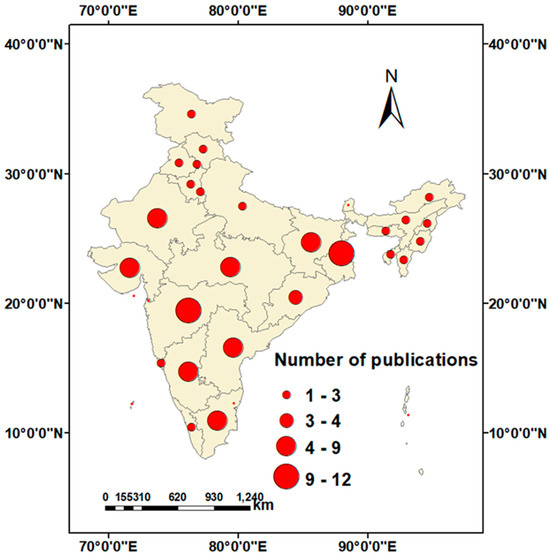
Figure 3.
Selected geospatial technology-based articles related to agricultural water management conducted in different parts of India.
The distribution of the selected studies was examined annually, as shown in Figure 4. The trajectory of research in India regarding the integration of geospatial technologies shows significant fluctuations. As depicted in Figure 4, there was no consistent increase in studies between 2014 and 2020. However, in 2021, there was a notable surge in selected studies, marking a significant 18.33% increase. This trend peaked in 2022, with an increase of 23.33%. The rising number of published studies reflects a notable level of expertise and proficiency in geospatial technology in India. The widespread use of these modern methods bodes well for the nation’s long-term objectives pertaining to sustainable and profitable agriculture activities.
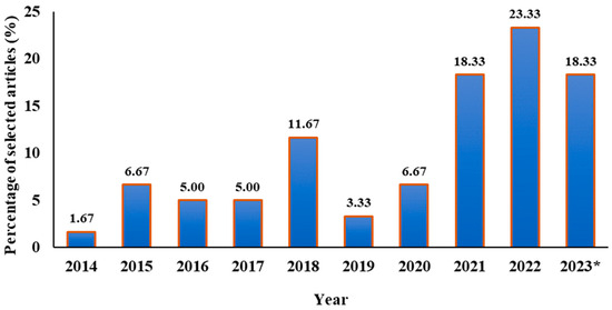
Figure 4.
Bar chart representing the percentage of recently published selected articles considered for review (* as of September 2023).
Over the years, data and products from numerous satellites and sensors have been employed for agricultural water management in India, as shown in Figure 5. In more than half of the selected studies, Landsat MSS/TM/ETM+/OLI satellite data were utilized. The 30 m spatial resolution and 16-day revisit cycle provided invaluable data for water resource management. Terra and Aqua (MODIS) are also widely used because they cover a larger area per scene, have satellite images available for the entire study period, and provide frequent data. Similarly, IRS satellites, particularly LISS III (23.5 m) and LISS IV (5.8 m), have been extensively employed in water management studies, specifically for monitoring water resources. These selected articles address different issues of agricultural water management, as shown in Figure 6. The percentage of studies selected to address different areas of agricultural water management in India is shown in Figure 6. The temporal scale of selected studies for data analysis concerning water management is shown in Figure 7. About 62% of the selected studies considered multi-year data and 38% of studies considered single-year data for addressing different water management issues. A variety of indices were utilized in the selected articles to target various facets of agricultural water management in India, and the distribution of selected articles among different remote sensing categories is depicted in Figure 8. Among the individual indices documented, NDVI emerged as the predominant choice for water management in the region, followed by NDWI as the second most frequently employed index. The most commonly utilized data source is multi-sensor type remote sensing followed by optical remote sensing for water management.
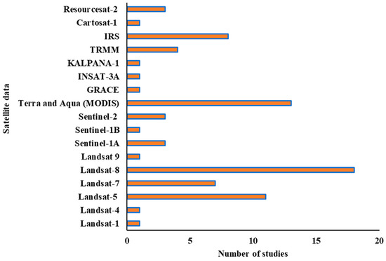
Figure 5.
Satellite data/products used in selected articles for agricultural water management in different parts of India.
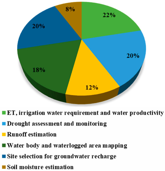
Figure 6.
Percentage of studies selected to address different areas of agricultural water management in India.
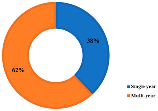
Figure 7.
Percentage of single- and multi-year studies considered in this review.
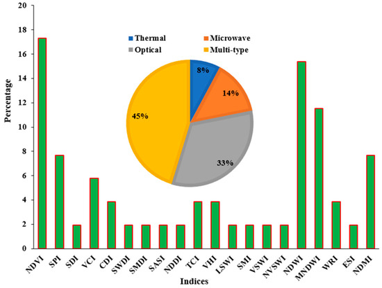
Figure 8.
The bar chart represents different indices used in the selected articles for addressing different areas of water management in India while the pie chart illustrates the percentage of selected articles across various remote sensing categories.
4. Discussion
India encounters water stress in many areas due to the limited utilization of its accessible water resources, with only a small fraction being effectively utilized [109]. Accurate, comprehensive, and timely agricultural information is crucial for decision making in a country like India, involving all stakeholders [110]. The long-term viability of agriculture depends on the sustainable management of available water resources. Therefore, it is essential to conduct a thorough and realistic assessment of water usage within the constraints of the limited available resources, coupled with careful future planning [111]. Improving water use efficiency in agriculture is crucial for sustainable water resource management. Implementing effective agricultural water management techniques on a regional scale is challenging due to the absence of real-time data on soil moisture and evapotranspiration. However, this challenge can be addressed through the utilization of geospatial technology [112,113]. Soil moisture is vital for plant growth, playing a key role in the hydrological cycle. Accurate measurement of this factor is crucial for agriculture, enabling early detection of drought warnings [105]. Assessing soil moisture changes over time and space is vital for pinpointing regions and periods facing significant water stress [114]. Soil moisture and vegetation water content are fundamental elements in studies concerning vegetation, drought, and climate change. Their significance is paramount in research within these fields [115]. The rising demand for irrigation has elevated the importance of estimating consumptive water use through geospatial techniques in the field of irrigation water management. Over the years, irrigation and agricultural applications have successfully used geospatial data [116]. Real-time irrigation scheduling can be achieved with the use of geospatial technology [117].
Due to significant fluctuations in climatic conditions, crops often experience various stresses, resulting in decreased productivity and yearly fluctuations. In such circumstances, the swift advancements in geospatial technology play a vital role in monitoring crop growth, identifying and managing different stress factors, and estimating regional yields. These technologies are essential for sustaining natural resources and agricultural productivity [33]. The growth of water-intensive crops, excessive irrigation, poor maintenance of drainage systems, and inadequate surface and subsurface drainage are the main causes of the waterlogging in the area [118]. For mapping areas that are flooded, conventional techniques such as ground surveys are employed; however, they are not economical or timely for studies conducted on a regional scale. A better real-time option for monitoring and determining the size of flooded areas is to integrate satellite remote sensing with GIS [119]. Analyzing surface runoff based on rainfall is a significant challenge in hydrological modeling, and is essential for water resource development, planning, and management. The surface runoff model dependent on rainfall is crucial for planning the development of water resources [120]. Precisely assessing surface runoff in watersheds, whether gauged or ungauged, is imperative for strategic planning and the implementation of water conservation structures [121]. Rapid urbanization has significantly reduced rainwater infiltration into the sub-soil, leading to a drastic decline in groundwater recharge. Consequently, rainwater harvesting has become essential due to the inadequacy of surface water to meet our needs, forcing us to rely heavily on groundwater. Rainwater harvesting refers to the purposeful collection and storage of rainwater, essentially augmenting groundwater reservoirs through human-made structures designed to capture and utilize rainwater effectively [122].
Traditional methods for gathering weather and crop growth data are reliable but laborious and time-consuming. In recent times, the integration of RS and GIS technologies has emerged as indispensable for obtaining spatio-temporal meteorological and crop status data, thereby augmenting conventional methodologies. RS data significantly aids monitoring by offering timely, comprehensive, cost-effective, and repetitive Earth surface information [33]. RS has substantiated its significant utility in the mapping and surveillance of agricultural land utilization, outperforming conventional methodologies in terms of cost-effectiveness and the expeditious provision of data across expansive territories. Satellite-based remote sensing, with its repetitive and multispectral nature, stands out as an ideal option for monitoring dynamic agricultural resources. For planners and policymakers, timely and reliable data on agricultural water management are essential for efficient and timely agricultural development, as well as for making critical decisions [110]. Satellite remote sensing provides significant prospects for the observation of land surface conditions and the monitoring of water resource status across diverse spatial and temporal scales. There is a growing necessity to harness RS technology for accurately estimating crop water requirements in irrigation areas [109]. RS stands out as one of the few techniques capable of offering representative measurements of numerous essential physical parameters, ranging from a specific point to an entire continent [123,124].
Advancements have been observed in the identification, mapping, and monitoring of water resources through the use of remotely sensed data over the years, as depicted in Figure 5. In our analysis, we found that a significant portion of research has predominantly utilized multispectral sensors. These sensors include a range of instruments like Landsat, MODIS, and IRS, with only a few studies opting for the use of Sentinel, TRMM, etc. The significant development of Earth-monitoring technologies is responsible for this research achievement. In terms of management, these technologies are economical and time-efficient. The abundance of data sources is a result of the availability of various instruments and missions. The dominance of the multispectral-based approach can be attributed to (a) the availability of extensive data from various satellite missions since the first Landsat mission in the 1970s, (b) a substantial number of free-of-cost optical sensors with improved resolution, particularly in recent years, and (c) the straightforward interpretation of data. Landsat sensors have proven particularly valuable for evaluating and monitoring water resources. It is important to acknowledge that the effectiveness of medium- and low-spatial-resolution sensors may be limited in detecting and mapping water resources, especially when dealing with areas smaller than the size of a pixel. The Landsat and Sentinel datasets, known for their improved spatial resolutions, have been traditionally employed for water resource management. While their images are freely available, handling them can be challenging due to their large file sizes. In the past, platforms like Earth Explorer from USGS or Sentinel–Copernicus Open Access Hub were used, but with the rise of cloud platforms like Google Earth Engine, managing and processing the entire dataset has become simpler. High-resolution images are now easily accessible, providing extensive coverage for large areas worldwide. MODIS is crucial for mapping changes in water resources at a broad spatial resolution. Its accessibility and extended operational period make it valuable for large-scale, long-term, and seasonal monitoring. Despite these advantages, using the MODIS sensor comes with challenges. One challenge is linking the coarse spatial resolution it offers with on-the-ground field data. Moreover, the sensor encounters difficulties when trying to effectively monitor small areas. The IRS satellite series provides high-resolution data useful for many applications, including natural resource management.
Cloud cover and limited temporal and spatial resolution are common challenges for multispectral sensors like Landsat sensors. Drones, on the other hand, operate at a lower altitude and can collect data over remote areas, meaning they are unaffected by cloud cover. Studies employing drones to manage water resources are currently lacking. Therefore, using drones to monitor water resources and comparing their performance with satellite sensors is necessary. In future studies, combining remotely sensed data with physical-based hydrologic models can lead to more effective water resource management and decision making. Further research is crucial to develop advanced models that use multi-source data and improved algorithms. Progress in Earth-observation technology, marked by enhanced image acquisition features, has steadily broadened our capability to identify the Earth’s features. Instruments like Sentinel-1 SAR offer a chance to combine optical and radar data, enhancing mapping capabilities even on cloudy days. It is crucial to monitor regions like semi-arid environments where significant rainfall happens during particular wet seasons. The integration of Sentinel-1 and -2 (SAR and MSI) data proves beneficial at a local to regional scale, yielding enhanced outcomes when compared to relying solely on the optical sensor. Sentinel-1 and -2 sensors are available for free and have successfully monitored water resources separately [125]. However, it was found that their complete potential has not been fully utilized in the evaluation and monitoring of water resources. As per the findings of this research, there is a growing interest in evaluating, mapping, and monitoring water resources using Landsat and MODIS image platforms. However, advanced Earth-observation technologies like Sentinel data, UAVs, and hyperspectral technology have not been fully investigated for assessing and monitoring water resources. The application of these advanced technologies could be effective in keeping track of water resources.
5. Progress and Future Scope
Undoubtedly, the 2030 Agenda for Sustainable Development establishes ambitious objectives, encompassing targets such as Sustainable Development Goal (SDG)-1 (Eradication of poverty) and SDG-2 (Zero hunger), which strives to enhance agricultural productivity and implement sustainable, resilient agricultural practices. Furthermore, SDG-12 (Responsible consumption and production) directs attention towards the promotion of sustainable patterns in production and consumption. Simultaneously, SDG-13 (Climate action) and SDG-15 (Life on land) underscore the imperative for sustainable management of natural resources. To align with these objectives, it is imperative to systematically and scientifically redesign agricultural policies and programs. This redesign should aim to incentivize sustainable agricultural practices and enhance food security, ensuring the harmonious integration of ecological and economic principles for long-term agricultural viability [34]. Finding appropriate solutions for agricultural water management is crucial, particularly in countries anticipating population growth and increased production and consumption. These solutions need to focus on monitoring and addressing various aspects of agricultural water management while evaluating the effects of threats such as climate change, food security, spatial planning, and land management on the system. The diversity of data sources emphasizes the availability of instruments and missions at our disposal. The extensive adoption of the multispectral-based approach can be attributed to various factors. Firstly, there is an availability of extensive data from various satellite missions, dating back to the 1970s with the launch of the first Landsat mission. Secondly, the availability of numerous free optical sensors, with significantly improved resolutions in recent years, has bolstered this trend. Lastly, the straightforward and uncomplicated interpretation of the data has also played a significant role in the widespread adoption of this approach [126]. Optical sensors are frequently used because of their simple processing and the ease of interpreting their images. These sensors closely match human visual perception, making them a preferred option for researchers.
Due to the better spatial resolutions offered, Landsat-(5, 6, 7, 8) TM, ETM+, OLI/TIRS (30 m), IRS–LISS III (24 m), IRS–LISS IV (5.8 m), and Sentinel-1, -2 (10 m) are mostly used to address different issues of agricultural water management in India. These finer resolutions are particularly valuable for addressing water management concerns in relatively small areas. Nevertheless, the launch of Landsat-9 on 27 September 2021 has halved the revisit period, sparking expectations of increased utilization of these data in the upcoming years. Data from Terra and Aqua MODIS, offering resolutions ranging from 250 to 1000 m, are predominantly utilized owing to the wider coverage per scene, the availability of satellite imagery throughout the entire study period, and, primarily, their temporal resolution. The Terra and Aqua MODIS instruments systematically acquire imagery of the Earth’s entire surface at intervals of one to two days, establishing them as indispensable tools in scientific research. Within the domain of water resource management, researchers have commonly utilized a multispectral or radar-based approach.
Even though we have made progress in using geospatial technology for long-term monitoring, there is a delay in quickly adopting modern Earth-observation methods, including Sentinel data, that are easy to access. Sentinels, with better spectral resolution and a 5-day revisit time, open up new possibilities for checking water resources every two weeks or each season. Multispectral sensors like those in Sentinel 2 and Landsat face challenges with cloudy weather and coarser spatial and temporal resolution. The future upcoming sensors, such as the NASA-ISRO SAR Mission (NISAR), can be a game-changing satellite, which will allow detailed scientific insights into sustainability for agricultural water management under climate change scenarios.
Different emerging technologies like cloud computing, augmented reality, Internet of Things (IoT), 3D GIS, mobile GIS, machine learning, artificial intelligence, hyperspectral drones and balloons, blockchain, digital twins, and robotics, as depicted in Figure 9, are poised to enhance the future of water management [127]. The evaluation and monitoring of water resources using these advanced technologies have not received considerable attention until now. Advanced algorithms and software in cloud computing can be used to comprehensively analyze field conditions for water management. Integrating GIS with the IoT is crucial for automating irrigation systems for water management. This combination promises transformative effects not only in the irrigation sector, but also across various industries. Augmented reality, a research domain merging actual surroundings with computer-generated data, enhances real-time human perception in water management. In water management, 3D GIS enhances object details and visibility by introducing an additional dimension (z-axis). The inclusion of an elevation component that is lacking in 2D maps can provide a comprehensive representation and 3D GIS technologies offer illustrative scale representations for real-world objects. Mobile GIS streamlines feasibility studies for water management, empowering field personnel to collect, store, update, edit, analyze, and present geospatial data. The integration of mobile devices, GIS software, GPS, and wireless connectivity enables internet-based GIS access. The amalgamation of RS, GIS, and artificial intelligence promotes the automation of data collection, analysis, and decision making in water management [126]. Drones, which fly lower, are not affected by clouds and can reach remote, hard-to-access areas to collect data. With the advancement of technology (the fourth industrial revolution), using drones in future studies is recommended. They offer a new and innovative way to gather real-time spatial data, especially for mapping and monitoring water resources. Balloons, when filled with helium gas, can operate at lower altitudes compared to airplanes, making them valuable for detecting small objects [36]. Digital twins can be used for the prediction of crop irrigation requirements and irrigation water management [128]. Robotics and blockchain are also useful for irrigation water management.
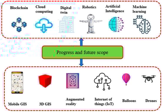
Figure 9.
Technological advancements for progress and futuristic agricultural water management.
In achieving sustainable water management amidst a growing population and its increasing needs, utilizing multispectral sensor data is crucial. This information is highly valuable for professionals in water management, catchment management, and land planning. It empowers them to customize their strategies for managing land and water by taking into account spatial differences and seasonal variations in water resources.
6. Conclusions
This review encompassed 60 recently published research articles in the field of agricultural water resource management, specifically focusing on geospatial technology applications. The ever-expanding global population, coupled with pressing issues such as the consequences of ongoing climate change, exerts significant pressure on agricultural systems. Consequently, there is a growing need for advanced monitoring systems and models that can provide comprehensive insights into how countries are strategically managing spatial planning, land and water resources, and food security. In response to this need, this paper systematically evaluated cutting-edge geospatial technology solutions in this field, adhering to the rigorous guidelines outlined in the PRISMA statement. This methodological approach proved highly effective in quantifying essential information regarding various parameters of interest within the subject. The resulting information holds considerable value for forthcoming studies in the field. As the world is changing very rapidly and factors like climate change, seasonal patterns, and water scarcity are projected to become more noticeable, these factors will play a significant role in enhancing the development of precise monitoring tools.
The literature shows that geospatial technology is receiving a lot of attention for agricultural water management. We observed that different remote sensing spectral indices are used for agricultural water management in the study area. Here, we found that most of the studies focus on Landsat images, overlooking the potential of other sensors like Sentinel-1 and -2. These sensors have better revisit times and improved spatial resolution and radiometric capabilities, but they have not been explored as much. Seasonal monitoring is rendered possible by these sensors. According to the results of this study, there is an increasing interest in assessing, mapping, and monitoring water resources using Landsat and MODIS image platforms. However, more advanced Earth-observation technologies such as Sentinel data, UAVs, and hyperspectral technology have not been thoroughly explored for the assessment and monitoring of water resources in the study area. Using data from different sensors helps us learn more about water resources. Platforms like drones and helium-filled balloons enable the acquisition of high-resolution data in near real time, substantially enhancing the precision of mapping and monitoring water resources. Advancements in machine learning algorithms that reduce processing time for data will significantly improve the application of machine learning in remote sensing. Machine learning can effectively organize data obtained from systematic ground observations, sensors, meteorological instruments, and various remote sensing sources like satellites, airborne platforms, and drones. It is concluded that the fusion of cloud computing, IoT, artificial intelligence, 3D GIS, mobile GIS, augmented reality, hyperspectral drones and balloons, robotics, digital twins, and blockchain with GIS and remote sensing technologies can revolutionize agriculture, maintaining a crucial role in agricultural water management. The Google Earth Engine (GEE) platform, renowned for its ability to manage large-scale remote sensing data, stands as a valuable and time-efficient tool for water management. The effective management of water resources at both local and regional scales requires the full integration of innovative technologies and methodologies. These advancements have markedly enhanced our capability to assess and monitor water resources, thereby enabling the implementation of more efficient planning and management strategies. The advancements in geospatial technology applications have furthered our comprehension of water resources, thereby promoting sustainable water management practices. Hence, this research significantly contributes to the existing literature by offering a comprehensive analysis of the advancements in geospatial technology within the realm of agricultural water management in India, providing a holistic perspective. The advancement of new sensors, both passive and active, offering superior spatial, spectral, radiometric, and temporal resolutions, along with enhanced data integration techniques and the availability of sophisticated algorithms/software and platforms, enables the efficient utilization of geospatial technology to tackle the aforementioned challenges.
Author Contributions
Conceptualization, S.B.T., N.R.P., A.D. and S.P.; methodology, S.B.T., N.R.P., A.D., S.P. and B.R.P.; resources, N.R.P. and A.D.; data curation, S.B.T., N.R.P., A.D. and S.P.; writing—original draft preparation, S.B.T.; writing—review and editing, S.B.T., N.R.P. and B.R.P.; visualization, S.B.T., N.R.P. and B.R.P.; supervision, N.R.P. and B.R.P. All authors have read and agreed to the published version of the manuscript.
Funding
This research received no external funding.
Data Availability Statement
The authors confirm that the data supporting the findings of this study are available within the article.
Conflicts of Interest
The authors declare no conflicts of interest.
References
- Anusha, B.N.; Babu, K.R.; Kumar, B.P.; Kumar, P.R.; Rajasekhar, M. Geospatial Approaches for Monitoring and Mapping of Water Resources in Semi-Arid Regions of Southern India. Environ. Chall. 2022, 8, 100569. [Google Scholar] [CrossRef]
- Tripathi, A.; Tiwari, R.K. Synergetic Utilization of Sentinel-1 SAR and Sentinel-2 Optical Remote Sensing Data for Surface Soil Moisture Estimation for Rupnagar, Punjab, India. Geocarto Int. 2022, 37, 2215–2236. [Google Scholar] [CrossRef]
- Singh, P.K.; Jain, S.K.; Mishra, P.K.; Goel, M.K. An Assessment of Water Consumption Patterns and Land Productivity and Water Productivity Using WA+ Framework and Satellite Data Inputs. Phys. Chem. Earth Parts A/B/C 2022, 126, 103053. [Google Scholar] [CrossRef]
- Virnodkar, S.S.; Pachghare, V.K.; Patil, V.C.; Jha, S.K. Remote Sensing and Machine Learning for Crop Water Stress Determination in Various Crops: A Critical Review. Precis. Agric. 2020, 21, 1121–1155. [Google Scholar] [CrossRef]
- Pokhariyal, S.; Patel, N.R.; Govind, A. Machine Learning-Driven Remote Sensing Applications for Agriculture in India—A Systematic Review. Agronomy 2023, 13, 2302. [Google Scholar] [CrossRef]
- Chintalacheruvu, M.R.; Bardhan, A.; Pingale, S.M.; Patra, J.P. Water Footprint Analysis for the Upper Baitarani River Basin, India. Sustain. Water Resour. Manag. 2022, 8, 181. [Google Scholar] [CrossRef]
- Kesarwani, M.; Neeti, N.; Chowdary, V.M. Evaluation of Different Gridded Precipitation Products for Drought Monitoring: A Case Study of Central India. Theor. Appl. Climatol. 2023, 151, 817–841. [Google Scholar] [CrossRef]
- Shah, R.; Bharadiya, N.; Manekar, V. Drought Index Computation Using Standardized Precipitation Index (SPI) Method For Surat District, Gujarat. Aquat. Procedia 2015, 4, 1243–1249. [Google Scholar] [CrossRef]
- Patel, N.R.; Pokhriyal, S.; Singh, R.P. Advancements in Remote Sensing Based Crop Yield Modelling in India. J. Agrometeorol. 2023, 25, 293–299. [Google Scholar] [CrossRef]
- Balas, D.B.; Tiwari, M.K.; Patel, G.R. Estimation of Surface and Subsurface Soil Moisture Using Microwave Remote Sensing: A Typical Analysis. Int. J. Environ. Clim. Chang. 2023, 13, 1804–1816. [Google Scholar] [CrossRef]
- Shah, D.; Mishra, V. Integrated Drought Index (IDI) for Drought Monitoring and Assessment in India. Water Resour. Res. 2020, 56, e2019WR026284. [Google Scholar] [CrossRef]
- Dutta, D.; Kundu, A.; Patel, N.R.; Saha, S.K.; Siddiqui, A.R. Assessment of Agricultural Drought in Rajasthan (India) Using Remote Sensing Derived Vegetation Condition Index (VCI) and Standardized Precipitation Index (SPI). Egypt. J. Remote Sens. Sp. Sci. 2015, 18, 53–63. [Google Scholar] [CrossRef]
- Ravichandran, V.; Kantamaneni, K.; Periasamy, T.; Roy, P.D.; Killivalavan, J.; Sundar, S.; Chokkalingam, L.; Palanisamy, M. Monitoring of Multi-Aspect Drought Severity and Socio-Economic Status in the Semi-Arid Regions of Eastern Tamil Nadu, India. Water 2022, 14, 2049. [Google Scholar] [CrossRef]
- Chattopadhyay, N.; Malathi, K.; Tidke, N.; Attri, S.D.; Ray, K. Monitoring Agricultural Drought Using Combined Drought Index in India. J. Earth Syst. Sci. 2020, 129, 155. [Google Scholar] [CrossRef]
- Kulkarni, S.S.; Wardlow, B.D.; Bayissa, Y.A.; Tadesse, T.; Svoboda, M.D.; Gedam, S.S. Developing a Remote Sensing-Based Combined Drought Indicator Approach for Agricultural Drought Monitoring over Marathwada, India. Remote Sens. 2020, 12, 2091. [Google Scholar] [CrossRef]
- Bageshree, K.; Abhishek; Kinouchi, T. A Multivariate Drought Index for Seasonal Agriculture Drought Classification in Semiarid Regions. Remote Sens. 2022, 14, 3891. [Google Scholar] [CrossRef]
- Mishra, S.; Mahammood, V.; Durga Rao, K.H.V. Assessment of Irrigation Performance by Using Remote Sensing Techniques in Naryanpur Command Area, India. Environ. Ecol. Res. 2022, 10, 370–384. [Google Scholar] [CrossRef]
- Parmar, S.H.; Patel, G.R.; Tiwari, M.K. Assessment of Crop Water Requirement of Maize Using Remote Sensing and GIS. Smart Agric. Technol. 2023, 4, 100186. [Google Scholar] [CrossRef]
- Mukherjee, J.; Sharma, A.; Dhakar, R.; Sehgal, V.K.; Chakraborty, D.; Das, D.K. Estimation and Validation of Actual Evapotranspiration (ETa) of Maize Wheat Cropping System Using SSEBop Model Over IARI Research Farm, New Delhi, India. J. Indian Soc. Remote Sens. 2021, 49, 1823–1837. [Google Scholar] [CrossRef]
- Sindhu, D.; Shivakumar, B.L.; Ravikumar, A.S. Estimation of Surface Runoff in Nallur Amanikere. Int. J. Res. Eng. Technol. 2013, 404–409. [Google Scholar]
- Deoli, V.; Kumar, D.; Kumar, M.; Kuriqi, A.; Elbeltagi, A. Water Spread Mapping of Multiple Lakes Using Remote Sensing and Satellite Data. Arab. J. Geosci. 2021, 14, 2213. [Google Scholar] [CrossRef]
- Jhariya, D.C.; Kumar, T.; Gobinath, M.; Diwan, P.; Kishore, N. Assessment of Groundwater Potential Zone Using Remote Sensing, GIS and Multi Criteria Decision Analysis Techniques. J. Geol. Soc. India 2016, 88, 481–492. [Google Scholar] [CrossRef]
- Kanmani, K.; Vasanthi, P.; Pari, P.; Shafeer Ahamed, N.S. Estimation of Soil Moisture for Different Crops Using SAR Polarimetric Data. Civ. Eng. J. 2023, 9, 1402–1411. [Google Scholar] [CrossRef]
- Singh, L.K.; Jha, M.K.; Chowdary, V.M. Multi-Criteria Analysis and GIS Modeling for Identifying Prospective Water Harvesting and Artificial Recharge Sites for Sustainable Water Supply. J. Clean. Prod. 2017, 142, 1436–1456. [Google Scholar] [CrossRef]
- Anuradha, B.; Packialakshmi, S.; Sanjay, N.; Vivekananthan, V. An Analytical Study for Assessing Water Productivity in Pre- and Post-Rehabilitation Period of Rural Tank System. Adv. Civ. Eng. 2022, 2022, 1119931. [Google Scholar] [CrossRef]
- Ajay Kumar, V.; Mondal, N.C.; Ahmed, S. Identification of Groundwater Potential Zones Using RS, GIS and AHP Techniques: A Case Study in a Part of Deccan Volcanic Province (DVP), Maharashtra, India. J. Indian Soc. Remote Sens. 2020, 48, 497–511. [Google Scholar] [CrossRef]
- Saranya, T.; Saravanan, S. Groundwater Potential Zone Mapping Using Analytical Hierarchy Process (AHP) and GIS for Kancheepuram District, Tamilnadu, India. Model. Earth Syst. Environ. 2020, 6, 1105–1122. [Google Scholar] [CrossRef]
- Singh, L.K.; Jha, M.K.; Chowdary, V.M. Planning Rainwater Conservation Measures Using Geospatial and Multi-Criteria Decision Making Tools. Environ. Sci. Pollut. Res. 2021, 28, 1734–1751. [Google Scholar] [CrossRef]
- Asgher, M.S.; Kumar, N.; Kumari, M.; Ahmad, M.; Sharma, L.; Naikoo, M.W. Groundwater Potential Mapping of Tawi River Basin of Jammu District, India, Using Geospatial Techniques. Environ. Monit. Assess. 2022, 194, 240. [Google Scholar] [CrossRef]
- Yadav, B.; Patidar, N.; Sharma, A.; Panigrahi, N.; Sharma, R.K.; Loganathan, V.; Krishan, G.; Singh, J.; Kumar, S.; Parker, A. Assessment of Traditional Rainwater Harvesting System in Barren Lands of a Semi-Arid Region: A Case Study of Rajasthan (India). J. Hydrol. Reg. Stud. 2022, 42, 101149. [Google Scholar] [CrossRef]
- Jayswal, P.S.; Gontia, N.K.; Sondarva, K.N.; Patel, V.A. Site Selection for Rainwater Harvesting Using Remote Sensing, GIS and AHP. Int. J. Plant Soil Sci. 2023, 35, 1360–1378. [Google Scholar] [CrossRef]
- Meraj, G.; Kanga, S.; Ambadkar, A.; Kumar, P.; Singh, S.K.; Farooq, M.; Johnson, B.A.; Rai, A.; Sahu, N. Assessing the Yield of Wheat Using Satellite Remote Sensing-Based Machine Learning Algorithms and Simulation Modeling. Remote Sens. 2022, 14, 3005. [Google Scholar] [CrossRef]
- Kingra, P.K.; Majumder, D.; Singh, S.P. Application of Remote Sensing and Gis in Agriculture and Natural Resource Management Under Changing Climatic Conditions. Agric. Res. J. 2016, 53, 295. [Google Scholar] [CrossRef]
- Bhat, Y.; Nandy, S.; Padalia, H.; Nath, A.J.; Pebam, R. Role of Geospatial Technology in Shifting Cultivation Studies in India: A Systematic Review. J. Indian Soc. Remote Sens. 2022, 50, 2359–2379. [Google Scholar] [CrossRef]
- Cravero, A.; Pardo, S.; Sepúlveda, S.; Muñoz, L. Challenges to Use Machine Learning in Agricultural Big Data: A Systematic Literature Review. Agronomy 2022, 12, 748. [Google Scholar] [CrossRef]
- Mashala, M.J.; Dube, T.; Mudereri, B.T.; Ayisi, K.K.; Ramudzuli, M.R. A Systematic Review on Advancements in Remote Sensing for Assessing and Monitoring Land Use and Land Cover Changes Impacts on Surface Water Resources in Semi-Arid Tropical Environments. Remote Sens. 2023, 15, 3926. [Google Scholar] [CrossRef]
- Shwetha, H.R.; Kumar, D.N. Estimation of Daily Actual Evapotranspiration Using Vegetation Coefficient Method for Clear and Cloudy Sky Conditions. IEEE J. Sel. Top. Appl. Earth Obs. Remote Sens. 2020, 13, 2385–2395. [Google Scholar] [CrossRef]
- Jaiswal, R.K.; Lohani, A.K.; Galkate, R.V. Rainfall and Agro Related Climate Extremes for Water Requirement in Paddy Grown Mahanadi Basin of India. Agric. Res. 2023, 12, 20–31. [Google Scholar] [CrossRef]
- Parmar, H.V.; Gontia, N.K. Evapotranspiration Estimation Using Surface Energy Balance-Based Evaporative Fraction for Water Management in Canal Irrigation Command. J. Indian Soc. Remote Sens. 2022, 50, 373–384. [Google Scholar] [CrossRef]
- Kumar, U.; Srivastava, A.; Kumari, N.; Rashmi; Sahoo, B.; Chatterjee, C.; Raghuwanshi, N.S. Evaluation of Spatio-Temporal Evapotranspiration Using Satellite-Based Approach and Lysimeter in the Agriculture Dominated Catchment. J. Indian Soc. Remote Sens. 2021, 49, 1939–1950. [Google Scholar] [CrossRef]
- Adamala, S.; Rajwade, Y.A.; Reddy, Y.V.K. Estimation of Wheat Crop Evapotranspiration Using NDVI Vegetation Index. J. Appl. Nat. Sci. 2016, 8, 159–166. [Google Scholar] [CrossRef]
- Mondal, I.; Thakur, S.; De, A.; De, T.K. Application of the METRIC Model for Mapping Evapotranspiration over the Sundarban Biosphere Reserve, India. Ecol. Indic. 2022, 136, 108553. [Google Scholar] [CrossRef]
- Ramesh, J.; Jella, K.; Jogu, V. Evapotranspiration Estimation Using Geo-Spatial Techniques. Int. J. Sci. Res. Dev. 2021, 8, 217–220. [Google Scholar]
- Rao, J.H.; Hardaha, M.K.; Vora, H.M. The Water Footprint Assessment of Agriculture in Banjar River Watershed. Curr. World Environ. 2019, 14, 476–488. [Google Scholar] [CrossRef]
- Chanu, B.N.; Oinam, B. Assessment of Crop Yield and Water Footprint of Kharif Paddy Production under Different Rainfall Years. Songklanakarin J. Sci. Technol. 2023, 45, 451–455. [Google Scholar]
- Paul, G.C.; Saha, S. Measuring the Crop Water Demand and Satisfied Degree Using Remote Sensing Data and Machine Learning Method in Monsoon Climatic Region, India. Environ. Sci. Pollut. Res. 2023. ahead of print. [Google Scholar] [CrossRef] [PubMed]
- Madane, D.A.; Singh, M.C.; Sharma, P.; Mane, M. Water and Carbon Footprint Assessment of Onion Crop Cultivated under Differential Irrigation Scenarios. Arab. J. Geosci. 2023, 16, 419. [Google Scholar] [CrossRef]
- Sesha Sai, M.V.R.; Murthy, C.S.; Chandrasekar, K.; Jeyaseelan, A.T.; Diwakar, P.G.; Dadhwal, V.K. Agricultural Drought: Assessment & Monitoring. Mausam 2016, 67, 131–142. [Google Scholar]
- Sarkar, S. Drought and Flood Dynamics of Godavari Basin, India: A Geospatial Perspective. Arab. J. Geosci. 2022, 15, 772. [Google Scholar] [CrossRef]
- Deiveegan, M.; Pazhanivelan, S.; Ragunath, K.P.; Kumaraperumal, R. Detection of Agricultural Vulnerability to Drought Using NDVI and Land Surface Temperature in Salem and Namakkal Districts of Tamil Nadu. Adv. Life Sci. 2016, 5, 6868–6873. [Google Scholar]
- Nyayapathi, P.; Penki, R.; Basina, S.S. Drought Vulnerability Assessment by Employing the Geographical Information System and Analytical Hierarchy Process for the Kurnool District of Andhra Pradesh, India. Ecocycles 2023, 9, 32–48. [Google Scholar] [CrossRef]
- Sridhara, S.; Chaithra, G.M.; Gopakkali, P. Assessment and Monitoring of Drought in Chitradurga District of Karnataka Using Different Drought Indices. J. Agrometeorol. 2021, 23, 221–227. [Google Scholar] [CrossRef]
- Bajirao, T.S.; Kumar, P. Quantification of Impact of Spatio-Temporal Variability of Land Use/Land Cover on Runoff Generation Using Modified NRCS-CN Method. Arab. J. Geosci. 2022, 15, 610. [Google Scholar] [CrossRef]
- Bera, B.; Shit, P.K.; Sengupta, N.; Saha, S.; Bhattacharjee, S. Trends and Variability of Drought in the Extended Part of Chhota Nagpur Plateau (Singbhum Protocontinent), India Applying SPI and SPEI Indices. Environ. Chall. 2021, 5, 100310. [Google Scholar] [CrossRef]
- Prajapati, V.K.; Khanna, M.; Singh, M.; Kaur, R.; Sahoo, R.N.; Singh, D.K. PCA–Based Composite Drought Index for Drought Assessment in Marathwada Region of Maharashtra State, India. Theor. Appl. Climatol. 2022, 149, 207–220. [Google Scholar] [CrossRef]
- Palagiri, H.; Pal, M.; Maity, R. Drought Monitoring Using Satellite Soil Moisture Data Over Godavari Basin, India. In Lecture Notes in Civil Engineering; Springer: Berlin/Heidelberg, Germany, 2023; pp. 1–13. [Google Scholar]
- Das, P.K.; Das, D.K.; Midya, S.K.; Raj, U.; Dadhwal, V.K. Fore-Warning of Early Season Agricultural Drought Condition over Indian Region–a Fractional Wetness Approach. Geocarto Int. 2020, 35, 569–588. [Google Scholar] [CrossRef]
- Vyas, S.S.; Bhattacharya, B.K.; Nigam, R.; Guhathakurta, P.; Ghosh, K.; Chattopadhyay, N.; Gairola, R.M. A Combined Deficit Index for Regional Agricultural Drought Assessment over Semi-Arid Tract of India Using Geostationary Meteorological Satellite Data. Int. J. Appl. Earth Obs. Geoinf. 2015, 39, 28–39. [Google Scholar] [CrossRef]
- Kumaraperumal, R.; Pazhanivelan, S.; Ragunath, K.P.; Kannan, B.; Prajesh, P.J.; Mugilan, G.R. Agricultural Drought Monitoring in Tamil Nadu in India Using Satellite-Based Multi Vegetation Indices. J. Appl. Nat. Sci. 2021, 13, 414–423. [Google Scholar]
- Halder, B.; Tiyasha, T.; Shahid, S.; Yaseen, Z.M. Delineation of Urban Expansion and Drought-Prone Areas Using Vegetation Conditions and Other Geospatial Indices. Theor. Appl. Climatol. 2022, 149, 1277–1295. [Google Scholar] [CrossRef]
- Swain, S.; Mishra, S.K.; Pandey, A.; Dayal, D. Assessment of Drought Trends and Variabilities over the Agriculture-Dominated Marathwada Region, India. Environ. Monit. Assess. 2022, 194, 883. [Google Scholar] [CrossRef]
- Gumma, M.K.; Nelson, A.; Yamano, T. Mapping Drought-Induced Changes in Rice Area in India. Int. J. Remote Sens. 2019, 40, 8146–8173. [Google Scholar] [CrossRef]
- Sruthi, S.; Aslam, M.A.M. Agricultural Drought Analysis Using the NDVI and Land Surface Temperature Data; a Case Study of Raichur District. Aquat. Procedia 2015, 4, 1258–1264. [Google Scholar] [CrossRef]
- Medida, S.K.; Prasuna Rani, P.; Suneel Kumar, G.V.; Geetha Sireesha, P.V.; Kranthi, K.C.; Vinusha, V.; Sneha, L.; Naik, B.S.S.S.; Pramanick, B.; Brestic, M.; et al. Detection of Water Deficit Conditions in Different Soils by Comparative Analysis of Standard Precipitation Index and Normalized Difference Vegetation Index. Heliyon 2023, 9, e15093. [Google Scholar] [CrossRef] [PubMed]
- Sandeep, P.; Obi Reddy, G.P.; Jegankumar, R.; Arun Kumar, K.C. Monitoring of Agricultural Drought in Semi-Arid Ecosystem of Peninsular India through Indices Derived from Time-Series CHIRPS and MODIS Datasets. Ecol. Indic. 2021, 121, 107033. [Google Scholar] [CrossRef]
- Siddi Raju, R.; Sudarsana Raju, G.; Rajasekhar, M. Estimation of Rainfall Runoff Using SCS-CN Method with RS and GIS Techniques for Mandavi Basin in YSR Kadapa District of Andhra Pradesh, India. Hydrospatial Anal. 2018, 2, 1–15. [Google Scholar] [CrossRef]
- Gajbhiye, S. Estimation of Surface Runoff Using Remote Sensing and Geographical Information System. Int. J. u- e-Serv. Sci. Technol. 2015, 8, 113–122. [Google Scholar] [CrossRef]
- Jain, S.; Jaiswal, R.K.; Lohani, A.K.; Galkate, R. Development of Cloud-Based Rainfall–Run-Off Model Using Google Earth Engine. Curr. Sci. 2021, 121, 1433. [Google Scholar] [CrossRef]
- Srivastava, A.; Chinnasamy, P. Investigating Impact of Land-Use and Land Cover Changes on Hydro-Ecological Balance Using GIS: Insights from IIT Bombay, India. SN Appl. Sci. 2021, 3, 343. [Google Scholar] [CrossRef]
- Verma, S.; Singh, A.; Mishra, S.K.; Singh, P.K.; Verma, R.K. Efficacy of Slope-Adjusted Curve Number Models with Varying Initial Abstraction Coefficient for Runoff Estimation. Int. J. Hydrol. Sci. Technol. 2018, 8, 317–338. [Google Scholar] [CrossRef]
- Chanapathi, T.; Thatikonda, S.; Raghavan, S. Analysis of Rainfall Extremes and Water Yield of Krishna River Basin under Future Climate Scenarios. J. Hydrol. Reg. Stud. 2018, 19, 287–306. [Google Scholar] [CrossRef]
- Ibrahim-Bathis, K.; Ahmed, S.A. Rainfall-Runoff Modelling of Doddahalla Watershed—An Application of HEC-HMS and SCN-CN in Ungauged Agricultural Watershed. Arab. J. Geosci. 2016, 9, 170. [Google Scholar] [CrossRef]
- Natarajan, S.; Radhakrishnan, N. Assessment of Rainfall–Runoff Due to the Impacts of Land-Use Changes by Integrated Geospatial Empirical Approach: Study on Koraiyar Basin, Tiruchirappalli City, India. J. Indian Soc. Remote Sens. 2021, 49, 793–812. [Google Scholar] [CrossRef]
- Kumar, A.; Kanga, S.; Taloor, A.K.; Singh, S.K.; Đurin, B. Surface Runoff Estimation of Sind River Basin Using Integrated SCS-CN and GIS Techniques. HydroResearch 2021, 4, 61–74. [Google Scholar] [CrossRef]
- Satheeshkumar, S.; Venkateswaran, S.; Kannan, R. Rainfall–Runoff Estimation Using SCS–CN and GIS Approach in the Pappiredipatti Watershed of the Vaniyar Sub Basin, South India. Model. Earth Syst. Environ. 2017, 3, 24. [Google Scholar] [CrossRef]
- Nagaraj, R.; Kumar, L.S. Multi Scale Feature Extraction Network with Machine Learning Algorithms for Water Body Extraction from Remote Sensing Images. Int. J. Remote Sens. 2022, 43, 6349–6387. [Google Scholar] [CrossRef]
- Mishra, K.; Prasad, P.R.C. Automatic Extraction of Water Bodies from Landsat Imagery Using Perceptron Model. J. Comput. Environ. Sci. 2015, 2015, 903465. [Google Scholar] [CrossRef]
- Chakravorty, B.; Jha, R. Assessment of Spatio-Temporal Variation of Waterlogged Areas Lying Between Lower Gandak and Burhi Gandak Basins, India. J. Indian Soc. Remote Sens. 2022, 50, 583–596. [Google Scholar] [CrossRef]
- Ramji Satyaji Rao, Y. Mapping and Change Detection of Water Bodies in the Godavari Delta Using Geospatial Technology. ADBU-J. Eng. Technol. 2022, 11, 1–6. [Google Scholar]
- Roy Mukherjee, N.; Samuel, C. Assessment of the Temporal Variations of Surface Water Bodies in and around Chennai Using Landsat Imagery. Indian J. Sci. Technol. 2016, 9, 1–7. [Google Scholar] [CrossRef]
- Manoj, N.H.G.; Suresh, K.A.V.; Mani, A. Charectarization of Surface Water Dynamics in Krishna and Godavari River Basin by Using Remote Sensing and GIS Charectarization of Surface Water Dynamics in Krishna and Godavari River Basin by Using Remote Sensing and GIS. Adv. Life Sci. 2018, 5, 7349–7353. [Google Scholar]
- Sreekanth, P.D.; Krishnan, P.; Rao, N.H.; Soam, S.K.; Srinivasarao, C. Mapping Surface-Water Area Using Time Series Landsat Imagery on Google Earth Engine: A Case Study of Telangana, India. Curr. Sci. 2021, 120, 1491–1499. [Google Scholar] [CrossRef]
- Deoli, V.; Kumar, D.; Kuriqi, A. Detection of Water Spread Area Changes in Eutrophic Lake Using Landsat Data. Sensors 2022, 22, 6827. [Google Scholar] [CrossRef] [PubMed]
- Naik, B.C.; Anuradha, B. Extraction of Water-Body Area from High-Resolution Landsat Imagery. Int. J. Electr. Comput. Eng. 2018, 8, 4111. [Google Scholar] [CrossRef]
- Sahu, A.S. A Study on Moyna Basin Water-Logged Areas (India) Using Remote Sensing and GIS Methods and Their Contemporary Economic Significance. Geogr. J. 2014, 2014, 401324. [Google Scholar] [CrossRef]
- Kanga, S.; Singh, S.K. Mapping of Salt Affected and Waterlogged Areas Using Geospatial Technique. Int. J. Recent Innov. Trends Comput. Commun. 2017, 5, 1298–1305. [Google Scholar]
- Ghosh, S.; Mistri, B. Drainage Induced Waterlogging Problem and Its Impact on Farming System: A Study in Gosaba Island, Sundarban, India. Spat. Inf. Res. 2020, 28, 709–721. [Google Scholar] [CrossRef]
- Singh, S.K. Delineation of Waterlogged Areas in Vaishali District (Bihar) Using Normalized Difference Water Index. J. Clim. Chang. Water 2017, 1, 33–37. [Google Scholar]
- Selvarani, A.G.; Maheswaran, G.; Elangovan, K. Identification of Artificial Recharge Sites for Noyyal River Basin Using GIS and Remote Sensing. J. Indian Soc. Remote Sens. 2017, 45, 67–77. [Google Scholar] [CrossRef]
- Barik, K.K.; Dalai, P.C.; Goudo, S.P.; Panda, S.R.; Nandi, D. Delineation of Groundwater Potential Zone in Baliguda Block of Kandhamal District, Odisha Using Geospatial Technology Approach. Int. J. Adv. Remote Sens. GIS 2017, 6, 2068–2079. [Google Scholar] [CrossRef]
- Kolli, M.K.; Opp, C.; Groll, M. Mapping of Potential Groundwater Recharge Zones in the Kolleru Lake Catchment, India, by Using Remote Sensing and GIS Techniques. Nat. Resour. 2020, 11, 127–145. [Google Scholar] [CrossRef][Green Version]
- Rajasekhar, M.; Sudarsana Raju, G.; Siddi Raju, R.; Imran Basha, U. Data on Artificial Recharge Sites Identified by Geospatial Tools in Semi-Arid Region of Anantapur District, Andhra Pradesh, India. Data Br. 2018, 19, 462–474. [Google Scholar] [CrossRef]
- Shekar, P.R.; Mathew, A. Integrated Assessment of Groundwater Potential Zones and Artificial Recharge Sites Using GIS and Fuzzy-AHP: A Case Study in Peddavagu Watershed, India. Environ. Monit. Assess. 2023, 195, 906. [Google Scholar] [CrossRef] [PubMed]
- Pande, C.B.; Khadri, S.F.R.; Moharir, K.N.; Patode, R.S. Assessment of Groundwater Potential Zonation of Mahesh River Basin Akola and Buldhana Districts, Maharashtra, India Using Remote Sensing and GIS Techniques. Sustain. Water Resour. Manag. 2018, 4, 965–979. [Google Scholar] [CrossRef]
- Baghel, S.; Tripathi, M.P.; Khalkho, D.; Al-Ansari, N.; Kumar, A.; Elbeltagi, A. Delineation of Suitable Sites for Groundwater Recharge Based on Groundwater Potential with RS, GIS, and AHP Approach for Mand Catchment of Mahanadi Basin. Sci. Rep. 2023, 13, 9860. [Google Scholar] [CrossRef] [PubMed]
- Samson, S.; Elangovan, K. Delineation of Groundwater Recharge Potential Zones in Namakkal District, Tamilnadu, India Using Remote Sensing and GIS. J. Indian Soc. Remote Sens. 2015, 43, 769–778. [Google Scholar] [CrossRef]
- Ahirwar, S.; Malik, M.S.; Ahirwar, R.; Shukla, J.P. Application of Remote Sensing and GIS for Groundwater Recharge Potential Zone Mapping in Upper Betwa Watershed. J. Geol. Soc. India 2020, 95, 308–314. [Google Scholar] [CrossRef]
- Satapathy, I.; Syed, T.H. Characterization of Groundwater Potential and Artificial Recharge Sites in Bokaro District, Jharkhand (India), Using Remote Sensing and GIS-Based Techniques. Environ. Earth Sci. 2015, 74, 4215–4232. [Google Scholar] [CrossRef]
- Tiwari, K.; Goyal, R.; Sarkar, A. GIS-Based Methodology for Identification of Suitable Locations for Rainwater Harvesting Structures. Water Resour. Manag. 2018, 32, 1811–1825. [Google Scholar] [CrossRef]
- Saha, A.; Ghosh, M.; Chandra Pal, S. Identifying Suitable Sites for Rainwater Harvesting Structures Using Runoff Model (SCS-CN), Remote Sensing and GIS Techniques in Upper Kangsabati Watershed, West Bengal, India. In Geostatistics and Geospatial Technologies for Groundwater Resources in India; Springer Hydrogeology; Adhikary, P.P., Shit, P.K., Santra, P., Bhunia, G.S., Tiwari, A.K., Chaudhary, B.S., Eds.; Springer: Cham, Switzerland, 2021; ISBN 9783030623975. [Google Scholar]
- Waghaye, A.M.; Singh, D.K.; Sarangi, A.; Sena, D.R.; Sahoo, R.N.; Sarkar, S.K. Identification of Suitable Zones and Sites for Rainwater Harvesting Using GIS and Multicriteria Decision Analysis. Environ. Monit. Assess. 2023, 195, 279. [Google Scholar] [CrossRef]
- Chowdhury, M.; Paul, P.K. Identification of Suitable Sites for Rainwater Harvesting Using Fuzzy AHP and Fuzzy Gamma Operator: A Case Study. Arab. J. Geosci. 2021, 14, 585. [Google Scholar] [CrossRef]
- Kolekar, S.S.; Mishra, A.; Choudhari, P.; Choudhari, N.R. Identification of Specific Areas for Water Conservation Measures Using Geoinformatics Approach. Arab. J. Geosci. 2021, 14, 531. [Google Scholar] [CrossRef]
- Das, K.; Paul, P.K. Present Status of Soil Moisture Estimation by Microwave Remote Sensing. Cogent Geosci. 2015, 1, 1084669. [Google Scholar] [CrossRef]
- Srivastava, P.K.; Pandey, P.C.; Petropoulos, G.P.; Kourgialas, N.N.; Pandey, V.; Singh, U. GIS and Remote Sensing Aided Information for Soil Moisture Estimation: A Comparative Study of Interpolation Techniques. Resources 2019, 8, 70. [Google Scholar] [CrossRef]
- Parida, B.R.; Pandey, A.C.; Kumar, R.; Kumar, S. Surface Soil Moisture Retrieval Using Sentinel-1 SAR Data for Crop Planning in Kosi River Basin of North Bihar. Agronomy 2022, 12, 1045. [Google Scholar] [CrossRef]
- Rawat, K.S.; Sehgal, V.K.; Singh, S.K.; Ray, S.S. Soil Moisture Estimation Using Triangular Method at Higher Resolution from MODIS Products. Phys. Chem. Earth 2022, 126, 103051. [Google Scholar] [CrossRef]
- Sushanth, K.; Behera, A.; Mishra, A.; Singh, R. Assessment of Irrigation Demands Based on Soil Moisture Deficits Using a Satellite-Based Hydrological Model. Remote Sens. 2023, 15, 1119. [Google Scholar] [CrossRef]
- Gontia, N.K.; Tiwari, K.N. Estimation of Crop Coefficient and Evapotranspiration of Wheat (Triticum Aestivum) in an Irrigation Command Using Remote Sensing and GIS. Water Resour. Manag. 2010, 24, 1399–1414. [Google Scholar] [CrossRef]
- Ahmed, R.; Sajjad, H. Crop Acreage Estimation of Boro Paddy Using Remote Sensing and GIS Techniques: A Case from Nagaon District, Assam, India. Adv. Appl. Agric. Sci. 2015, 3, 16–25. [Google Scholar]
- Akhtar, M.P.; Roy, L.B.; Vishwakarma, K.M. Assessment of Agricultural Potential of a River Command Using Geo-Spatial Techniques: A Case Study of Himalayan River Project in Northern India. Appl. Water Sci. 2020, 10, 81. [Google Scholar] [CrossRef]
- Singh, R.K.; Kumar, P.; Mukherjee, S.; Suman, S.; Pandey, V.; Srivastava, P.K. Application of Geospatial Technology in Agricultural Water Management. In Agricultural Water Management; Academic Press: Cambridge, MA, USA, 2021. [Google Scholar]
- Senapati, D.; Pandey, A. Role of Geospatial Technology for Enhancement of Field Water Use Efficiency. In Geospatial Technologies for Land and Water Resources Management; Water Science and Technology Library; Pandey, A., Chowdary, V.M., Behera, M.D., Singh, V.P., Eds.; Springer: Cham, Switzerland, 2022; Volume 103. [Google Scholar]
- Reshmidevi, T.V.; Jana, R.; Eldho, T.I. Geospatial Estimation of Soil Moisture in Rain-Fed Paddy Fields Using SCS-CN-Based Model. Agric. Water Manag. 2008, 95, 447–457. [Google Scholar] [CrossRef]
- Viswambharan, S.; Kumaramkandath, I.T.; Tali, J.A. A Geospatial Approach in Monitoring the Variations on Surface Soil Moisture and Vegetation Water Content: A Case Study of Palakkad District, Kerala, India. Environ. Earth Sci. 2022, 81, 494. [Google Scholar] [CrossRef]
- Praveen, K.; Roy, L.B. Assessment of Irrigation and Agricultural Potential of the Sone Command Area in Bihar, India Applying Geospatial Techniques. J. Curr. Sci. Technol. 2022, 12, 568–581. [Google Scholar]
- Ray, S.; Dadhwal, V. Estimation of Crop Evapotranspiration of Irrigation Command Area Using Remote Sensing and GIS. Agric. Water Manag. 2001, 49, 239–249. [Google Scholar] [CrossRef]
- Pandey, A.C.; Singh, S.K.; Nathawat, M.S. Analysing the Impact of Anthropogenic Activities on Waterlogging Dynamics in Indo-Gangetic Plains, Northern Bihar, India. Int. J. Remote Sens. 2012, 33, 135–149. [Google Scholar] [CrossRef]
- Chowdary, V.M.; Chandran, R.V.; Neeti, N.; Bothale, R.V.; Srivastava, Y.K.; Ingle, P.; Ramakrishnan, D.; Dutta, D.; Jeyaram, A.; Sharma, J.R.; et al. Assessment of Surface and Sub-Surface Waterlogged Areas in Irrigation Command Areas of Bihar State Using Remote Sensing and GIS. Agric. Water Manag. 2008, 95, 754–766. [Google Scholar] [CrossRef]
- Karunanidhi, D.; Anand, B.; Subramani, T.; Srinivasamoorthy, K. Rainfall-Surface Runoff Estimation for the Lower Bhavani Basin in South India Using SCS-CN Model and Geospatial Techniques. Environ. Earth Sci. 2020, 79, 335. [Google Scholar] [CrossRef]
- Gavhane, K.P.; Mishra, A.K.; Sarangi, A.; Singh, D.K.; Sudhishri, S. Estimation of Surface Runoff Potential of an Ungauged Watershed in Semi-Arid Region Using Geospatial Techniques. Arab. J. Geosci. 2023, 16, 402. [Google Scholar] [CrossRef]
- Jasrotia, A.S.; Majhi, A.; Singh, S. Water Balance Approach for Rainwater Harvesting Using Remote Sensing and GIS Techniques, Jammu Himalaya, India. Water Resour. Manag. 2009, 23, 3035–3055. [Google Scholar] [CrossRef]
- Singh, A. Managing the Water Resources Problems of Irrigated Agriculture through Geospatial Techniques: An Overview. Agric. Water Manag. 2016, 174, 2–10. [Google Scholar] [CrossRef]
- Jain, S.K.; Jain, S.K.; Hariprasad, V.; Choudhry, A. Water Balance Study for a Basin Integrating Remote Sensing Data and GIS. J. Indian Soc. Remote Sens. 2011, 39, 259–270. [Google Scholar] [CrossRef]
- Munda, M.K.; Parida, B.R. Soil Moisture Modeling over Agricultural Fields Using C-Band Synthetic Aperture Radar and Modified Dubois Model. Appl. Geomat. 2023, 15, 97–108. [Google Scholar] [CrossRef]
- Fernández-Urrutia, M.; Arbelo, M.; Gil, A. Identification of Paddy Croplands and Its Stages Using Remote Sensors: A Systematic Review. Sensors 2023, 2, 6932. [Google Scholar] [CrossRef]
- Bwambale, E.; Naangmenyele, Z.; Iradukunda, P.; Agboka, K.M.; Houessou-Dossou, E.A.Y.; Akansake, D.A.; Bisa, M.E.; Hamadou, A.A.H.; Hakizayezu, J.; Onofua, O.E.; et al. Towards Precision Irrigation Management: A Review of GIS, Remote Sensing and Emerging Technologies. Cogent Eng. 2022, 9, 2100573. [Google Scholar] [CrossRef]
- Nasirahmadi, A.; Hensel, O. Toward the Next Generation of Digitalization in Agriculture Based on Digital Twin Paradigm. Sensors 2022, 22, 498. [Google Scholar] [CrossRef]


Disclaimer/Publisher’s Note: The statements, opinions and data contained in all publications are solely those of the individual author(s) and contributor(s) and not of MDPI and/or the editor(s). MDPI and/or the editor(s) disclaim responsibility for any injury to people or property resulting from any ideas, methods, instructions or products referred to in the content. |
© 2024 by the authors. Licensee MDPI, Basel, Switzerland. This article is an open access article distributed under the terms and conditions of the Creative Commons Attribution (CC BY) license (https://creativecommons.org/licenses/by/4.0/).