
Spatial-Temporal Mapping and Delineating of Agulu Lake Using Remote Sensing and Geographic Information Science for Sustainable Development †

Abstract
:1. Introduction
2. Description of the Study Area
3. Materials and Methods
4. Results and Discussion
5. Discussion
6. Conclusions and Recommendations
Author Contributions
Funding
Institutional Review Board Statement
Informed Consent Statement
Data Availability Statement
Conflicts of Interest
References
- Crétaux, J.-F.; Abarca-Del-Río, R.; Bergé-Nguyen, M.; Arsen, A.; Drolon, V.; Clos, G.; Maisongrande, P. Lake Volume Monitoring from Space. Surv. Geophys. 2016, 37, 269–305. [Google Scholar] [CrossRef]
- Gleeson, T.; Wada, Y.; Bierkens, M.F.P.; Van Beek, L.P.H. Water balance of global aquifers revealed by groundwater footprint. Nature 2012, 488, 197–200. [Google Scholar] [CrossRef] [PubMed]
- Messager, M.L.; Lehner, B.; Grill, G.; Nedeva, I.; Schmitt, O. Estimating the volume and age of water stored in global lakes using a geo-statistical approach. Nat. Commun. 2016, 7, 13603. [Google Scholar] [CrossRef] [PubMed]
- Omondi, R.; Kembenya, E.; Nyamweya, C.; Ouma, H.; Machua, S.; Ogari, Z. Recent limnological changes and their implication on fisheries in Lake Baringo, Kenya. J. Ecol. Nat. Environ. 2014, 6, 154–163. [Google Scholar] [CrossRef]
- Ma, L.; Wu, J.; Liu, W.; Abuduwaili, J. Distinguishing between Anthropogenic and climatic impacts on Lake Size: A modelling approach using data from Ebinur Lake in Arid Northwest China. J. Limnol. 2014, 73, 350–357. [Google Scholar] [CrossRef]
- United Nation. Sustainable Development Goal 6, Synthesis Report on Water and Sanitation; United Nations: New York, NY, USA, 2018; ISBN 9789211013702. OCLC 1107804829. [Google Scholar]
- United Nations & Nations. Transforming our world: The 2030 agenda for Sustainable Development. In Proceedings of the General Assembly 70 Session, New York, NY, USA, 25–27 September 2015. [Google Scholar] [CrossRef]
- Rokni, K.; Ahmad, A.; Selamat, A.; Hazini, S. Water Feature Extraction and Change Detection Using Multitemporal Landsat Imagery. Remote Sens. 2014, 6, 4173–4189. [Google Scholar] [CrossRef]
- Miles, K.E.; Willis, I.C.; Benedek, C.L.; Williamson, A.G.; Tedesco, M. Toward Monitoring Surface and Subsurface Lakes on the Greenland Ice Sheet Using Sentinel-1 SAR and Landsat-8 OLI Imagery. Front. Earth Sci. 2017, 5, 58. [Google Scholar] [CrossRef]
- Sichangi, A.W.; Makokha, G.O. Monitoring water depth, surface area and volume changes in Lake Victoria: Integrating the bathymetry map and remote sensing data during 1993–2016. Model. Earth Syst. Environ. 2017, 3, 533–538. [Google Scholar] [CrossRef]
- Okeke, I.O.C.; Nwokolo, O.C. Conservation and preservation of traditional Agulu Lake in Anambra State, Nigeria. In Proceedings of the Taal: 12th World Lake Conference, Jaipur, India, 15–19 October 2008; Volume 29, pp. 2209–2211. [Google Scholar]
- Egboka, B.; Nfor, B.; Banlanjo, E. Water budget analysis of Agulu Lake in Anambra State, Nigeria. J. Appl. Sci. Environ. Manag. 2006, 10, 27–30. [Google Scholar] [CrossRef]
- Singh, S.K.; Mustak, S.; Srivastava, P.K.; Szabó, S.; Islam, T. Predicting Spatial and Decadal LULC Changes Through Cellular Automata Markov Chain Models Using Earth Observation Datasets and Geo-information. Environ. Process. 2015, 2, 61–78. [Google Scholar] [CrossRef]


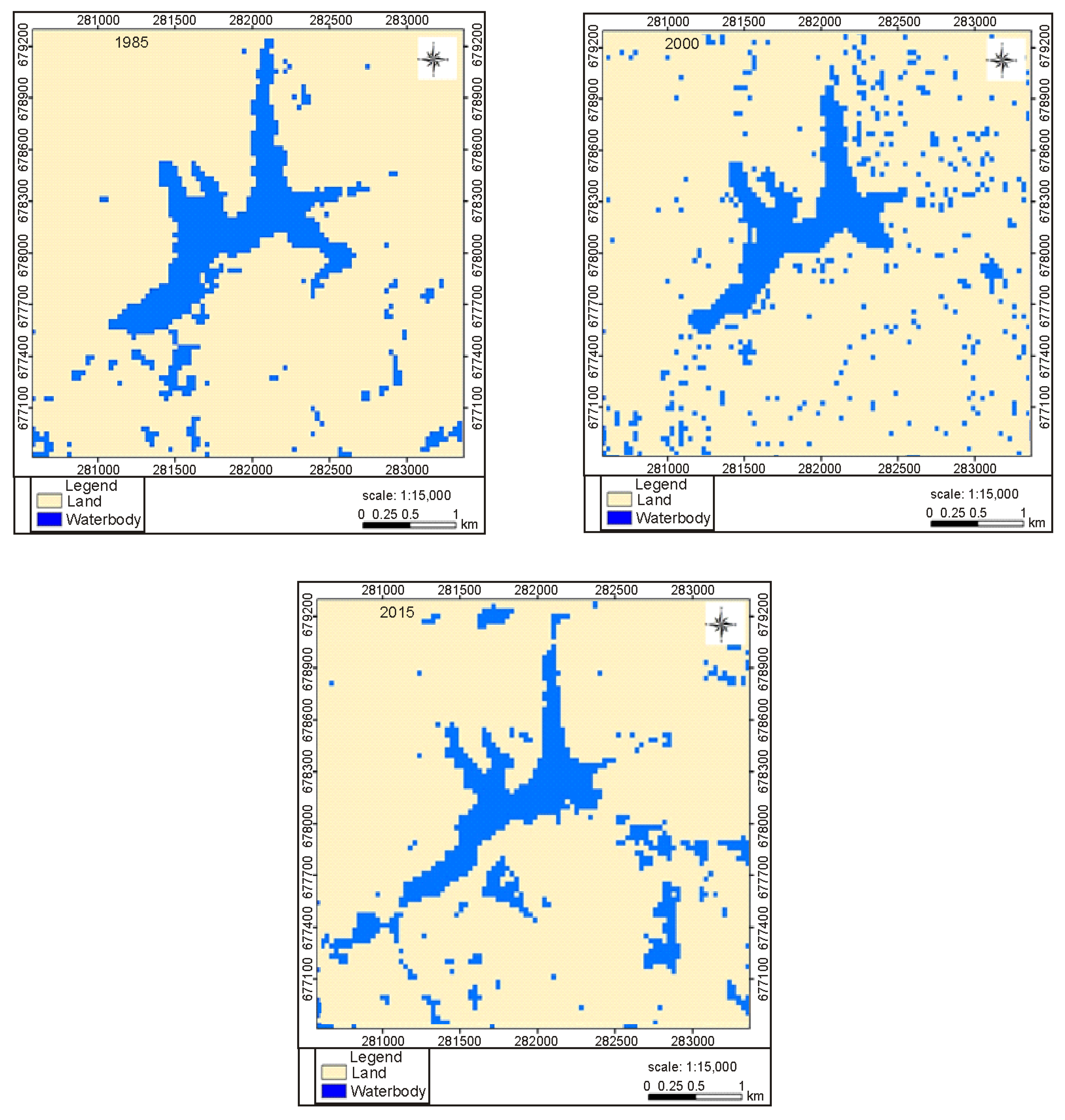
| Class Cover | 1985 | 2000 | 2015 | |||
|---|---|---|---|---|---|---|
| Area (m2) | Area (%) | Area (m2) | Area (%) | Area (m2) | Area (%) | |
| Land | 6,353,100 | 87.56 | 6,358,100 | 87.61 | 6,366,600 | 87.72 |
| River | 904,500 | 12.46 | 899,500 | 12.39 | 891,000 | 12.28 |
| Total | 7,257,600 | 100 | 7,257,600 | 100 | 7,257,600 | 100 |
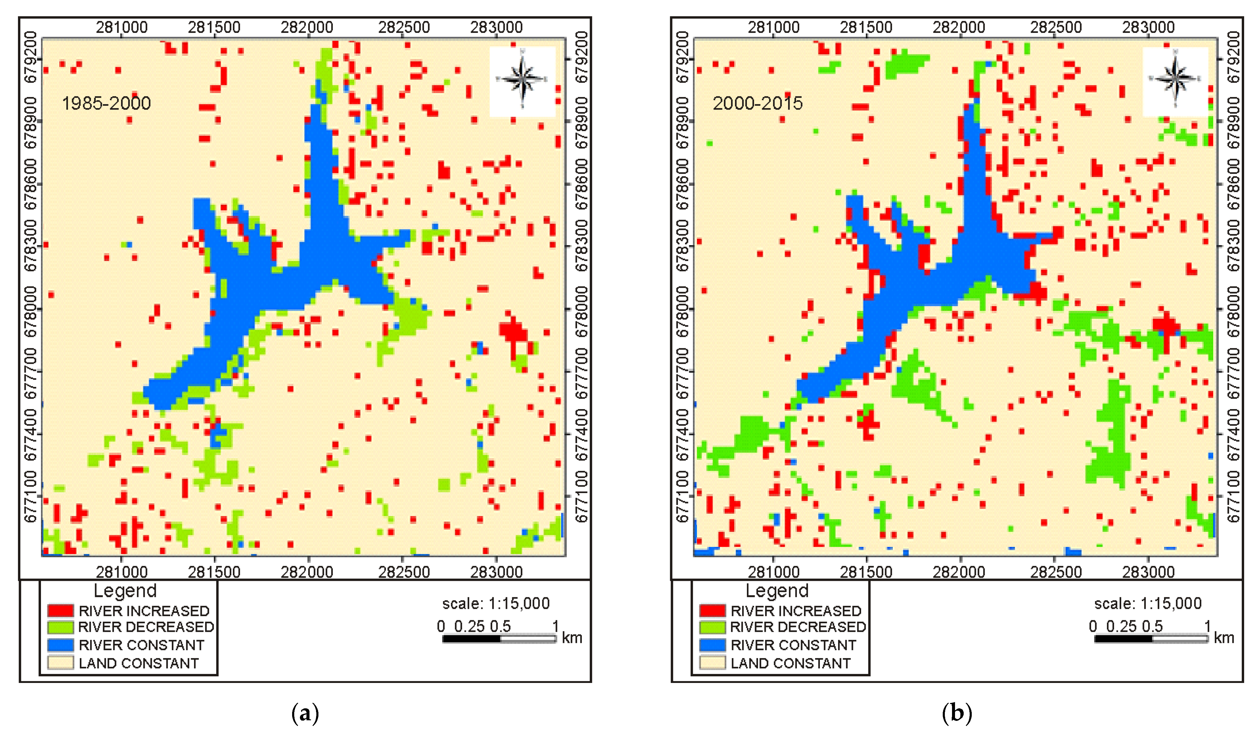
| 1985–2000 | 2000–2015 | ||||||||
|---|---|---|---|---|---|---|---|---|---|
| S/N | 1985 | 2000 | Area (m2) | Area (%) | 2000 | 2015 | Area (m2) | Area (%) | Change Detection |
| 1 | River | River | 544,500 | 7.50 | River | River | 448,200 | 6.18 | River constant |
| 2 | River | Land | 350,000 | 4.95 | River | Land | 456,300 | 6.29 | River decreased |
| 3 | Land | River | 370,000 | 4.96 | Land | River | 442,800 | 6.10 | River increased |
| 4 | Land | Land | 5,993,100 | 82.58 | Land | Land | 5,910,300 | 81.44 | Land constant |
| Total | 7,257,600 | 100.00 | 7,257,600 | 100.00 | |||||
Disclaimer/Publisher’s Note: The statements, opinions and data contained in all publications are solely those of the individual author(s) and contributor(s) and not of MDPI and/or the editor(s). MDPI and/or the editor(s) disclaim responsibility for any injury to people or property resulting from any ideas, methods, instructions or products referred to in the content. |
© 2023 by the authors. Licensee MDPI, Basel, Switzerland. This article is an open access article distributed under the terms and conditions of the Creative Commons Attribution (CC BY) license (https://creativecommons.org/licenses/by/4.0/).
Share and Cite
Enoh, M.A.; Okereke, C.A.; Narinua, N.Y. Spatial-Temporal Mapping and Delineating of Agulu Lake Using Remote Sensing and Geographic Information Science for Sustainable Development. Environ. Sci. Proc. 2023, 25, 57. https://doi.org/10.3390/ECWS-7-14259
Enoh MA, Okereke CA, Narinua NY. Spatial-Temporal Mapping and Delineating of Agulu Lake Using Remote Sensing and Geographic Information Science for Sustainable Development. Environmental Sciences Proceedings. 2023; 25(1):57. https://doi.org/10.3390/ECWS-7-14259
Chicago/Turabian StyleEnoh, Mfoniso Asuquo, Chukwudi Andy Okereke, and Needam Yiinu Narinua. 2023. "Spatial-Temporal Mapping and Delineating of Agulu Lake Using Remote Sensing and Geographic Information Science for Sustainable Development" Environmental Sciences Proceedings 25, no. 1: 57. https://doi.org/10.3390/ECWS-7-14259
APA StyleEnoh, M. A., Okereke, C. A., & Narinua, N. Y. (2023). Spatial-Temporal Mapping and Delineating of Agulu Lake Using Remote Sensing and Geographic Information Science for Sustainable Development. Environmental Sciences Proceedings, 25(1), 57. https://doi.org/10.3390/ECWS-7-14259