Studies dealing with wildland fire at global or continental scales normally use coarse-resolution spatial units, within which fire-regime components are aggregated for statistical purposes. Here, we developed the first European pyrogeography based on different fire-regime components to better capture the spatial heterogeneity of fire regimes. Pyroregions were delineated through the identification of similar distributions of fire-regime components computed from a remote sensing dataset over the period 2001–2018. We identified four large-scale pyroregions with different patterns of fire activity across the continent. The spatial mismatch between the pyrogeography and ecoregions suggests that other factors, besides vegetation-based classification systems, are driving fire regimes in Europe. Comparisons of interannual climate–fire relationships at different spatial aggregations presented stronger relationships (R2 = 0.65) at the pyroregion level (Figure 1). Overall, the developed pyrogeography provides a level of generalization that aids in understanding fire regimes and contributes to improving the performance of statistical models that predict future fire regimes. Therefore, pyroregions can also be understood as a tool for effective fire risk management and planning.
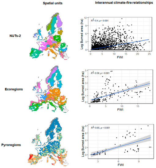
Figure 1.
Comparisons of the interannual relationships between burned area and fire-weather index (FWI) at different spatial aggregations from the period 2001–2018. The color code in the maps represents the different spatial units for each type of aggregation. Scatterplots presented the interannual correlation (Pearson) between annual burned area and FWI at different aggregations.
Author Contributions
Conceptualization, L.F.G., T.C., R.B. and M.R.; formal analysis, L.F.G.; writing—original draft preparation, L.F.G.; writing—review and editing, L.F.G., T.C., R.B. and M.R. All authors have read and agreed to the published version of the manuscript.
Funding
This research was funded by the project MED-Star, supported by the European Union under the Operational Program Italy/France Maritime (project No. CUP E88H19000120007).
Institutional Review Board Statement
Not applicable.
Informed Consent Statement
Not applicable.
Data Availability Statement
All the data that support this study are open access and can be accessed using websites or data repositories described below. Remotely sensed fire dataset is available at https://doi.pangaea.de/10.1594/PANGAEA.895835 (accessed on 16 March 2021). The ERA5 high-resolution reanalysis of the Canadian FWI System indices are available at https://cds.climate.copernicus.eu/cdsapp#!/dataset/cems-fire-historical?tab=overview (accessed on 2 February 2021).
Conflicts of Interest
The authors declare no conflict of interest.
Publisher’s Note: MDPI stays neutral with regard to jurisdictional claims in published maps and institutional affiliations. |
© 2022 by the authors. Licensee MDPI, Basel, Switzerland. This article is an open access article distributed under the terms and conditions of the Creative Commons Attribution (CC BY) license (https://creativecommons.org/licenses/by/4.0/).