Introduction
Tasmania is a large island (68,401 km2) that lies 200 km south of the south-eastern Australian mainland. The island has a maritime temperate climate with a steep west to east rainfall gradient (>3000 to <500 mm mean annual precipitation associated with the preponderance of rain-bearing westerly winds that are intercepted by rugged low (<2000 m) mountain ranges and plateaux (Figure 1). The geology of the island is very varied with fine-scale assortments of sedimentary, metamorphic, and igneous rocks. Across the island, higher elevation landscapes have been exposed to glacial and periglacial erosion, while lowland areas in drier areas have deeply weathered regolith, sometimes overlain with aeolian landforms. The mid-latitudinal position of the island (40 to 43.5° S) leads to very strong slope aspect effects on solar radiation, which, combined with elevation temperature gradients and topographic rain shadows, influences microclimate and soil moisture [1]. Collectively, the interplay of geology, geomorphology, rainfall, and temperature gradients contributes to the rich flora and fauna that has numerous endemic species of plants and animals with diverse biogeographic patterns [2,3,4].
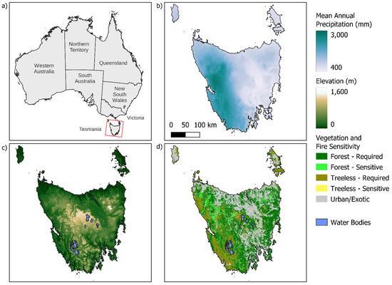
Figure 1.
Geography of Tasmania. (a) location of Tasmania with respect to mainland Australia Patterns of: (b) mean annual precipitation [8]; (c) elevation [9]; (d) forest/woodland and treeless vegetation broken down by fire requiring and fire sensitive types, derived from TasVeg 4.0 mapping [10].
A feature of Tasmanian vegetation patterns are mosaics of fire-dependent and fire-sensitive vegetation types (Figure 1). Embedded in large tracts of flammable Eucalyptus forests and treeless vegetation are more geographically restricted fire-sensitive vegetation types such as wet and dry rainforests and alpine shrublands (Figure 1). The biota of these fire-sensitive habitats include numerous ‘living fossils’ with direct roots to the Gondwanan supercontinent [5]: the terrains of Tasmania formed the last geological connection between the Australian and Antarctic land masses before they were separated by continental drift some 60 million years ago. Tasmania has an ancient human history that commenced around 35,000 year ago when the first humans crossed a land bridge from continental Australia that was open by low sea levels during the late-Pleistocene era [6]. Since then, Tasmanian Aboriginal people have used landscape fire skillfully to manage game and maintain open areas for travel routes, and this active land management contributed to the persistence of fire-sensitive vegetation [7].
This constellation of biogeographic factors has made the island of Tasmania a fascinating and globally significant ‘pyrogeographic laboratory’. Indeed, the extraordinarily insightful conceptual paper about fire vegetation-driven dynamics was published by Jackson in 1968 [11] based on his extensive Tasmanian field experience. This paper anticipated numerous key concepts in fire ecology, including fire-driven alternative stable states, the effect of fire on soil nutrient capital, and the evolution of flammability and post-fire regeneration strategies [12]. Further, Tasmania has featured prominently in debates about Aboriginal fire use in shaping landscapes and the legacy effects of the disruption of this ancient land management traditions [7]. The effect of vegetation patterns is not only related to changed fire regimes following the extirpation of Tasmanian Aboriginal people from traditional lands, but also to substantial ecological knock-on effects associated with changed ignition patterns and altered fuel loads stemming from resource exploitation (prospecting, land clearing, pastoralism, forestry) and increased human population densities.
Fire management is of paramount importance in Tasmania given the threat of uncontrolled bushfires. For example, 62 people were killed and nearly 3,000 structures were destroyed in the capital city Hobart in the 1967 Black Tuesday bush fires, and in 2013 the village of Dunalley was severely impacted by a firestorm [13]. In contrast to such disasters, controlled fire is also a critical tool in regenerating logged forests and native pastures as well as protecting settlements, infrastructure, and fire sensitive vegetation. Prescribed burning of treeless flammable vegetation is particularly important in the Tasmanian Wilderness World Heritage Area (TWWHA) that conserves the largest remaining temperate wilderness areas in the southern hemisphere, covering around 20% of the western half of Tasmania. A management challenge in the TWWHA is maintaining fire-sensitive Tasmanian endemic vegetation in a matrix of flammable treeless and forest vegetation (Figure 1). An added complexity is that widespread organic soils supporting both flammable and fire-sensitive vegetation are vulnerable to destruction under drought conditions [14].
Like much of the world, the climate of Tasmania is changing due to anthropogenic greenhouse gas emissions. Since the 1950s, mean annual air temperatures have risen by 0.10 °C per decade, and since the mid 1970s, rainfall has declined across Tasmania, particularly in autumn months [15]. Downscaled climate change modelling for Tasmania suggests this drying trend will continue through the 21st century with drier summer and autumn months, partially offset by wetter winter and spring months [15], which will certainly affect fire weather conditions [16,17]. There is emerging evidence of a change in fire activity, with a steady increase since the 1990s in the number and the extent of bushfires ignited by lightning storms [18]. Since 1990, there has been a steady increase in the area of Tasmania burned by landscape fires, amounting to entirely one quarter of the island (Figure 2).
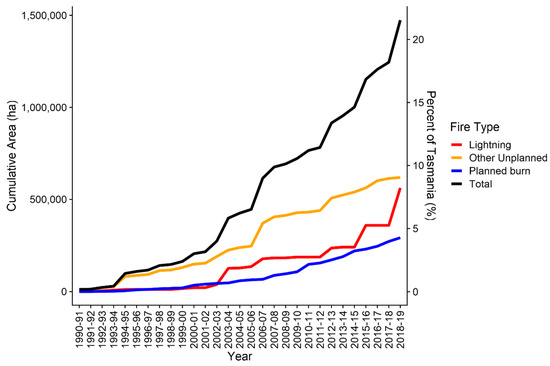
Figure 2.
Cumulative area (in ha and % of the area of Tasmania) burned since 1990. The area burned is broken down by planned, lightning and other unplanned fires.
Since the beginning of this century, there have been three particularly active and high-impact fire seasons in Tasmania: 2012–2013, 2015–2016 and 2018–2019. All were associated with high temperatures and drought, and large, rain-free lightning storms, affecting the TWWHA [5,19,20], with substantial property damage associated with the 2012–2013 fire season [13], and extensive damage to forestry resources in the 2018-19 season [21]. Smoke pollution from the 2015–2016 and 2018–2019 fires caused demonstrable harms to human health [22]. Each of these fire seasons was sufficiently unprecedented to trigger a range of government inquiries investigating their causes and impacts as well as possible adaptation pathways to better manage these events [23,24,25,26]. This sequence of fire seasons suggested there is a trend for far more fire activity in Tasmania, prompting this Special Issue of Fire to document changing fire regimes and fire impacts on Tasmania.
This Special Issue touches on many issues central to understand how fire activity has changed across Tasmania through the Holocene [27], the impact and recovery of forest and shrub vegetation following recent fires [20,28], geographical patterns of lightning ignitions [29], fire severity patterns across forest-treeless vegetation boundaries [30], analysis of fire risk using soil moisture and river flow data [31], and the influence of a changing climate on dominant forest trees [32]. These articles highlight the complexity of fire management in Tasmania, especially associated with rapid changes driven by the Anthropocene. Such complexity makes Tasmania an ideal setting for understanding the interplay of the legacies, current and future direct and indirect effects on humans and climate on shaping biodiverse, flammable environments.
- Dedication
We dedicate this volume to our colleague Rebecca Harris who passed away in late 2021 after battling a serious illness. Rebecca was a prime mover in initiating this volume and served as a guest co-editor. Rebecca had a passion for climate change adaptation, working closely with a diverse range of public and private partners and research across a range of fields and was a lead author on the IPCC’s Sixth Assessment Report, Climate Change 2021: Impacts, Adaptation and Vulnerability. We miss a friend, collaborator, and champion of climate adaptation science.
Author Contributions
Conceptualization, D.M.J.S.B.; writing—review and editing, D.M.J.S.B., C.A.K. and G.J.W.; visualization, G.J.W. All authors have read and agreed to the published version of the manuscript.
Funding
This Special Issue stemmed from the University of Tasmania sponsoring CAK as a Visiting Scholar in 2018–2019.
Conflicts of Interest
The authors declare no conflict of interest.
References
- Kirkpatrick, J.; Nunez, M. Vegetation-radiation relationships in mountainous terrain: Eucalypt-dominated vegetation in the Risdon Hills, Tasmania. J. Biogeogr. 1980, 7, 197–208. [Google Scholar] [CrossRef]
- Reid, J.B. Vegetation of Tasmania; Australian Biological Resources Study: Melbourne, Australia, 1998. [Google Scholar]
- Crisp, M.D.; Laffan, S.; Linder, H.P.; Monro, A. Endemism in the Australian flora. J. Biogeogr. 2001, 28, 183–198. [Google Scholar] [CrossRef]
- Williams, W.D. Biogeography and Ecology in Tasmania; Springer Science & Business Media: Dordrecht, The Netherlands, 2012; Volume 25. [Google Scholar]
- Bowman, D.M.; Rodriguez-Cubillo, D.; Prior, L.D. The 2016 Tasmanian wilderness fires: Fire regime shifts and climate change in a Gondwanan biogeographic refugium. In Ecosystem Collapse and Climate Change; Springer: Cham, Switzerland, 2021; pp. 133–153. [Google Scholar]
- O’Connell, J.F.; Allen, J.; Williams, M.A.; Williams, A.N.; Turney, C.S.; Spooner, N.A.; Kamminga, J.; Brown, G.; Cooper, A. When did Homo sapiens first reach Southeast Asia and Sahul? Proc. Natl. Acad. Sci. USA 2018, 115, 8482–8490. [Google Scholar] [CrossRef] [Green Version]
- Jones, P.J.; Williamson, G.J.; Bowman, D.M.; Lefroy, E.C. Mapping Tasmania’s cultural landscapes: Using habitat suitability modelling of archaeological sites as a landscape history tool. J. Biogeogr. 2019, 46, 2570–2582. [Google Scholar] [CrossRef]
- Fick, S.E.; Hijmans, R.J. WorldClim 2: New 1-km spatial resolution climate surfaces for global land areas. Int. J. Climatol. 2017, 37, 4302–4315. [Google Scholar] [CrossRef]
- Farr, T.G.; Kobrick, M. Shuttle Radar Topography Mission produces a wealth of data. Eos Trans. Am. Geophys. Union 2000, 81, 583–585. [Google Scholar] [CrossRef]
- Department of Primary Industries Parks Water and Environment. TASVEG—The Digital Vegetation Map of Tasmania. Available online: https://dpipwe.tas.gov.au/conservation/development-planning-conservation-assessment/planning-tools/monitoring-and-mapping-tasmanias-vegetation-(tasveg)/tasveg-the-digital-vegetation-map-of-tasmania (accessed on 17 February 2022).
- Jackson, W.D. Fire, air, water and earth-an elemental ecology of Tasmania. Proc. Ecol. Soc. Aust. USA 1968, 3, 9–16. [Google Scholar]
- Bowman, D.M.J.S.; Wood, S.W. Fire-driven land cover change in Australia and W.D. Jackson’s theory of the fire ecology of southwest Tasmania. In Tropical Fire Ecology: Climate Change, Land Use, and Ecosystem Dynamics; Springer: Berlin/Heidelberg, Germany, 2009; pp. 87–111. [Google Scholar]
- Ndalila, M.N.; Williamson, G.J.; Bowman, D.M. Geographic patterns of fire severity following an extreme eucalyptus forest fire in southern Australia: 2013 Forcett-Dunalley fire. Fire 2018, 1, 40. [Google Scholar] [CrossRef] [Green Version]
- Prior, L.D.; French, B.J.; Storey, K.; Williamson, G.J.; Bowman, D.M. Soil moisture thresholds for combustion of organic soils in western Tasmania. Int. J. Wildland Fire 2020, 29, 637–647. [Google Scholar] [CrossRef]
- Grose, M.; Barnes-Keoghan, I.; Corney, S.; White, C.; Holz, G.; Bennett, J.; Gaynor, S.; Bindoff, N. Climate futures for Tasmania: General Climate Impacts Technical Report; Antarctic Climate & Ecosystems Cooperative Research Centre: Hobart, Tasmania, 2010. [Google Scholar]
- Fox-Hughes, P. A fire danger climatology for Tasmania. Aust. Meteorol. Mag. 2008, 57, 109–120. [Google Scholar]
- Fox-Hughes, P.; Harris, R.; Lee, G.; Grose, M.; Bindoff, N. Future fire danger climatology for Tasmania, Australia, using a dynamically downscaled regional climate model. Int. J. Wildland Fire 2014, 23, 309–321. [Google Scholar] [CrossRef]
- Styger, J.; Marsden-Smedley, J.; Kirkpatrick, J. Changes in lightning fire incidence in the Tasmanian wilderness world heritage area, 1980–2016. Fire 2018, 1, 38. [Google Scholar] [CrossRef] [Green Version]
- French, B.J.; Prior, L.D.; Williamson, G.J.; Bowman, D.M. Cause and effects of a megafire in sedge-heathland in the Tasmanian temperate wilderness. Aust. J. Bot. 2016, 64, 513–525. [Google Scholar] [CrossRef]
- Foulkes, J.A.; Prior, L.D.; Leonard, S.W.J.; Bowman, D.M.J.S. Demographic effects of severe fire in montane shrubland on Tasmania’s Central Plateau. Fire 2021, 4, 32. [Google Scholar] [CrossRef]
- Prior, L.D.; Foyster, S.M.; Furlaud, J.M.; Williamson, G.J.; Bowman, D.M. Using permanent forest plots to evaluate the resilience to fire of Tasmania’s tall wet eucalypt forests. For. Ecol. Manag. 2022, 505, 119922. [Google Scholar] [CrossRef]
- Borchers-Arriagada, N.; Palmer, A.J.; Bowman, D.M.; Williamson, G.J.; Johnston, F.H. Health impacts of ambient biomass smoke in Tasmania, Australia. Int. J. Environ. Res. Public Health 2020, 17, 3264. [Google Scholar] [CrossRef]
- Tasmanian Government. 2013 Tasmanian Bushfires Inquiry Report. Available online: https://www.dpac.tas.gov.au/divisions/osem/2013_tasmanian_bushfires_inquiry_report/2013_tasmanian_bushfires_inquiry_report (accessed on 20 February 2022).
- Press, A.J. Tasmanian Wilderness World Heritage Area Bushfire and Climate Change Research Project. Available online: https://www.dpac.tas.gov.au/__data/assets/pdf_file/0011/313013/TWWHA_Bushfire_and_Climate_Change_Research_Project_December_2016_Executive_Summary.pdf (accessed on 20 February 2022).
- Australian Senate Environment and Communications References Committee. Responses to, and Lessons Learnt from, the January and February 2016 Bushfires in Remote Tasmanian Wilderness. Available online: https://www.aph.gov.au/Parliamentary_Business/Committees/Senate/Environment_and_Communications/TasmanianBushfires45/Report (accessed on 20 February 2022).
- Australasian Fire and Emergency Service Authorities Council. AFAC Independent Operational Review: A Review of the Management of the Tasmanian Fires of December 2018–March 2019. Available online: https://www.fire.tas.gov.au/userfiles/AFAC/AFAC_Review.pdf (accessed on 20 February 2022).
- Adeleye, M.A.; Haberle, S.G.; Connor, S.E.; Stevenson, J.; Bowman, D.M.J.S. Indigenous Fire-Managed Landscapes in Southeast Australia during the Holocene—New Insights from the Furneaux Group Islands, Bass Strait. Fire 2021, 4, 17. [Google Scholar] [CrossRef]
- Wardlaw, T. Measuring a fire. The Story of the January 2019 fire told from measurements at the Warra Supersite, Tasmania. Fire 2021, 4, 15. [Google Scholar] [CrossRef]
- Nampak, H.; Love, P.; Fox-Hughes, P.; Watson, C.; Aryal, J.; Harris, R.M.B. Characterizing spatial and temporal variability of lightning activity associated with wildfire over Tasmania, Australia. Fire 2021, 4, 10. [Google Scholar] [CrossRef]
- Hillman, S.; Hally, B.; Wallace, L.; Turner, D.; Lucieer, A.; Reinke, K.; Jones, S. High-resolution estimates of fire severity—An evaluation of UAS image and LiDAR mapping approaches on a sedgeland forest boundary in Tasmania, Australia. Fire 2021, 4, 14. [Google Scholar] [CrossRef]
- Bowman, D.M.; Williamson, G.J. River Flows Are a Reliable Index of Forest Fire Risk in the Temperate Tasmanian Wilderness World Heritage Area, Australia. Fire 2021, 4, 22. [Google Scholar] [CrossRef]
- Lucas, J.; Harris, R.M.B. Changing climate suitability for dominant Eucalyptus species may affect future fuel loads and flammability in Tasmania. Fire 2021, 4, 1. [Google Scholar] [CrossRef]
Publisher’s Note: MDPI stays neutral with regard to jurisdictional claims in published maps and institutional affiliations. |
© 2022 by the authors. Licensee MDPI, Basel, Switzerland. This article is an open access article distributed under the terms and conditions of the Creative Commons Attribution (CC BY) license (https://creativecommons.org/licenses/by/4.0/).