Abstract
This study presents an improved UAV-based structure inspection method that integrates advanced 3D modeling and optimized path planning with obstacle avoidance. The system uses Meshroom, an open-source software, to combine multiple sets of 3D point clouds collected by a UAV-mounted 3D camera into a complete 3D model of the structure. Because point cloud data typically contain an overwhelming number of points, they are grouped into smaller sets, each represented by an oriented bounding box (OBB). This step significantly reduces the complexity in path-planning calculations. The UAV, modeled as a flying sphere, initially moves along a straight path from its starting point to a target position. A gradient-based optimization method then adjusts this trajectory to maintain a safe distance between the UAV and the OBBs representing the obstacles. The results show that the proposed method successfully generates safe and efficient UAV flight paths, improving both the accuracy and safety of UAV-based structure inspections.
1. Introduction
Unmanned aerial vehicles (UAVs) have become increasingly essential in architectural inspections due to their flexibility, efficiency, and ability to access areas that are challenging or hazardous for human inspectors. Traditional inspection methods often involve significant time, risks, and costs, particularly when dealing with complex structures like bridges, high-rise buildings, and intricate infrastructure. UAV-based inspections not only mitigate these issues but also enable rapid, high-quality data acquisition, facilitating timely assessments of structural conditions and early detection of potential damages, such as cracks or corrosion. Despite these advantages, navigating UAVs in complex environments introduces challenges, notably ensuring collision-free flight paths around architectural obstacles, which necessitates accurate and efficient path-planning methods.
To address these challenges, this paper introduces an integrated approach combining advanced 3D modeling and optimized path planning. High-density point clouds gathered from UAV-mounted 3D cameras typically result in computational complexity that hampers real-time path planning and collision avoidance. Therefore, effectively simplifying and modeling these datasets are critical. By utilizing advanced point cloud simplification and oriented bounding box (OBB) techniques, the proposed system significantly reduces computational demands, enabling real-time navigation and safe operations around complex structures. Such an innovative combination not only enhances UAV inspection accuracy and safety but also demonstrates strong practical applicability in the inspection and maintenance of modern and historic architectures.
2. Presented Methodologies of UAV Architecture Inspection with Collision-Avoiding Path Planning
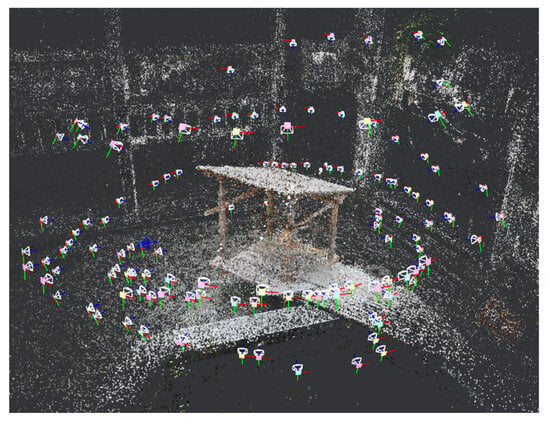
The sequential process of generating an optimized, collision-free UAV trajectory for architectural inspections is presented as follows. Initially, multiple 3D point clouds are captured from various UAV positions around the target architecture using a UAV-mounted 3D camera. As shown in Figure 1, these individual point clouds are then combined into a comprehensive and precise 3D model of the structure using advanced 3D reconstruction techniques, specifically the Structure from Motion (SfM) [] approach implemented in the open-source software Meshroom 2024 [].

Figure 1.
The 3D modeling of the architecture based on the 3D point clouds collected at multiple UAV positions.
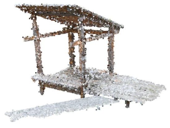
The detailed 3D point cloud usually consists of a vast number of data points, significantly complicating real-time trajectory calculations and collision avoidance tasks. To overcome this issue, a density-based spatial clustering method (DBSCAN) [] is applied to filter out noise and irrelevant data points, effectively reducing the dataset complexity. The filtered 3D point cloud of the architecture is shown in Figure 2.

Figure 2.
A filtered point cloud model of the architecture based on density-based spatial clustering of applications with noise (DBSCAN).
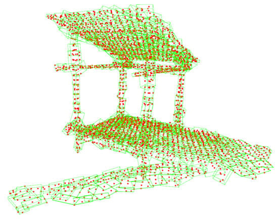
Following clustering, the simplified data points are further grouped and encapsulated within oriented bounding boxes (OBBs), as shown in Figure 3. These bounding boxes greatly reduce computational complexity by abstracting the dense point cloud data into fewer manageable obstacles.

Figure 3.
Oriented bounding box (OBB) models of the architecture.
Finally, an optimization problem is formulated to find the new waypoints by minimizing the sum of squared deviations from the original waypoints, subject to collision avoidance constraints. These constraints require that the distances between each new waypoint and the nearby architecture OBBs must remain greater than or equal to a specified safety threshold. This constrained optimization problem [] is shown in Equation (1).
where is the original UAV configuration in the collision region (for ); is the new UAV configuration; is the obstacle; is the Danger Factor (DF); is the allowable DF; and are the lower and upper bounds of the UAV configuration, respectively. Equation (1) is reformulated as an unconstrained Lagrangian minimization problem, as shown in Equation (2).
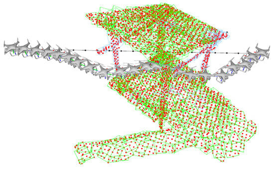
where , , and are the Lagrangian multipliers; , , and are the slack variables. The Steepest Descent method is utilized to solve the unconstrained optimization problem using one-dimensional Newton’s method to conduct a line search. The optimized UAV flying trajectory is shown in Figure 4. This integrated optimization framework ensures reliable and practical UAV navigation, significantly enhancing both the safety and efficiency of architectural inspection tasks in complex environments.

Figure 4.
Three-dimensional path planning of UAV with collision avoidance achieved by gradient-based optimization.
3. Conclusions
The study introduces an effective UAV-based architecture inspection system by integrating advanced 3D modeling techniques, point cloud simplification, and gradient-based trajectory optimization for collision avoidance. By leveraging Meshroom software for accurate structure modeling and utilizing a two-stage DBSCAN approach to simplify complex datasets into manageable oriented bounding boxes (OBBs), the computational efficiency of path planning was greatly enhanced. The application of the Steepest Descent optimization method with a one-dimensional Newton-based line search ensures reliable, collision-free trajectories. The proposed method demonstrates significant improvements in UAV inspection processes, offering a practical and scalable solution suitable for complex structural inspections. Future developments could focus on further automating real-time onboard computations and exploring applications for collaborative multi-UAV inspection scenarios.
Author Contributions
P.-C.C. contributed on system integration, programming, experiments and testing, data analysis, report preparation, etc. P.T.L. contributed on research concept, algorithm derivation, funding search, reseach collaboration, etc. All authors have read and agreed to the published version of the manuscript.
Funding
This research was funded by National Science and Technology Council, Taiwan (grant number NSTC 113-2221-E-011-101).
Institutional Review Board Statement
Not applicable.
Informed Consent Statement
Not applicable.
Data Availability Statement
There is no data available for this publication.
Conflicts of Interest
The authors declare no conflicts of interest.
References
- Westoby, M.J.; Brasington, J.; Glasser, N.F.; Hambrey, M.J.; Reynolds, J.M. ‘Structure-from-Motion’ photogrammetry: A low-cost, effective tool for geoscience applications. Geomorphol. 2012, 179, 300–314. [Google Scholar] [CrossRef]
- AliceVision. Meshroom: A 3D Reconstruction Software; GitHub: San Francisco, CA, USA, 2024. [Google Scholar]
- Ester, M.; Kriegel, H.-P.; Sander, J.; Xu, X. A density-based algorithm for discovering clusters in large spatial databases with noise. In Proceedings of the KDD, Portland, OR, USA, 2–4 August 1996; pp. 226–231. [Google Scholar]
- Chen, P.-C. Obstacle-Avoiding Path Planning for Unmanned Aerial Vehicle Inspection Based on Lagrangian Minimization. Master’s Thesis, Department of Mechanical Engineering, National Taiwan University of Science and Technology, Taipei, Taiwan, 2025. [Google Scholar]
Disclaimer/Publisher’s Note: The statements, opinions and data contained in all publications are solely those of the individual author(s) and contributor(s) and not of MDPI and/or the editor(s). MDPI and/or the editor(s) disclaim responsibility for any injury to people or property resulting from any ideas, methods, instructions or products referred to in the content. |
© 2025 by the authors. Licensee MDPI, Basel, Switzerland. This article is an open access article distributed under the terms and conditions of the Creative Commons Attribution (CC BY) license (https://creativecommons.org/licenses/by/4.0/).