Abstract
Since the 1990s, a series of rural development aid programs (LEADER Approach) has been implemented in European rural areas, including Extremadura, in order to solve the demographic, social, and economic problems that rural areas experience. The main objective of these programs is to diversify the economy to reverse these problems. The purpose of this present paper is to study the distribution of the investments committed during the period of 2000–2013 in Extremadura according to the geolocation and to perform the analysis of clusters through Local Moran’s I, Getis-Ord Gi*, and Kernel Density in order to determine whether the results are related to the demographic and economic behavior of each territory of action and if these act as location factors for investments. We found that most dynamic towns receive more investments, leaving out the more physically, economically, and demographically disadvantaged ones.
1. Introduction
Despite having a great historical and natural legacy with various development policies that are applied in its territory, Extremadura continues to be considered one of the least developed regions of the European Union, since its GDP (Gross Domestic Product) is still below 75% of the European average (unique in Spain). Furthermore, this region still has serious structural demographic and economic problems as a consequence of the intense emigration experienced in previous decades and its natural limitations, unequal distribution of land and resources, extensive area, and low productivity. All of these factors have created an excessive dependence on the agricultural sector, which is still very present in regional employment (10%) and Gross Value Added (8%) [1].
The rural territory is of great importance in the configuration of the Extremadura region, as it is one of the key elements in its social and economic structure. Furthermore, the rural area provides the physical support for a vast and varied natural and cultural heritage, which has served as a base of many economic activities that generate important levels of employment and income through the LEADER (Liaisons entre activités de Development de L’Economie Rural) Approach. Since 1991, the EU objective has been activating the potential of rural areas and stabilizing its population through diversification of economic activities with the introduction of new ones to complement the agricultural sector [2]. The other objects include preserving the rural heritage, maintaining an adequate demographic level or promoting the use of new technologies [3] and ensuring sustainable rural development [4], paying special attention to the agro-environmental aspect, which has also been widely studied by authors, such us Gabrielli et al. [5], Jaraite and Kazukauskas [6], Marconi et al. [7], and Ziolkowska [8].
Thus, with the LEADER Approach, an integrated, endogenous, innovative, and alternative to the traditional rural development model implemented by the public administrations was carried out, with the participation of the local population in decision making and in the design of the territorial rural development strategies of each area of coverage [9]. Strategies are developed through projects co-financed by the European Structural Funds, the General State Administration, the regional government, and various private agents.
Over the last 25 years, several European Funds have financed LEADER, including the European Regional Development Fund (ERDF), European Social Fund (ESF), and European Agricultural Guarantee Fund (EAGF). Currently, the European Agricultural Fund for Rural Development (EAFRD) finances rural development aid, having been regulated in the period of 2007–2013 by Regulation 1698/2005 and by Regulation 1305/2013 in the newly launched period of 2014–2020. In this newly launched period, the LEADER Approach has come to be designated a PLD (Participative Local Development). The Local Action Groups (LAGs), which are non-profit associations, are responsible for the management and concession of the projects to be subsidized and all of the actors of the territory are represented in them. In this way, the population acts as an actor and benefactor of the rural development aid through these groups. At present, there are 24 LAGs operating in Extremadura, which cover 98.8% of the municipalities (except the municipalities considered as urban: Badajoz, Cáceres, Mérida, and Plasencia) and 70.8% of the population.
Territory is essential for the LEADER Approach, as it acts as the subject and source of resources as well as being subjected to physical, economic, and social conditions [10]. In this sense, the Extremadura region presents an important diversity of territories with demographic and economic characteristics that may act as localization factors for LEADER projects and investments. As a result, the characteristics may be influencing the distribution of these territories, thus creating differences between the more developed and less-favored rural areas [11]. Under this hypothesis, the objective of this work is to study the distribution of projects in Extremadura in the period of 2000–2013, according to geolocation, and to perform the analysis of spatial location patterns through a GIS (Geographic Information System). The final aim is to know if the demographic and economic behaviors of each territory influence the distribution of rural development aid in Extremadura and show the reality of its application. This may not support what has been pursued in recent years, such as reducing the demographic and socio-economic differences between rural and urban areas.
In this context, there are several studies where the distribution of LEADER investments in different Spanish regions have been analyzed with consideration of certain factors, such as area, population, and the type of action measures [1,11,12,13] at the municipal or LAG level. Several European regions with similar territorial characteristics to those of Extremadura have also been the subject studies, such as Greece [14], Italy [15], Romania [16], or Croatia [17]. In these studies, the variables about the distribution of investments by inhabitants and areas, financing measures, type of promoters, and the creation of employment are analyzed.
However, this paper advances on previous studies in describing statistically and geographically the spatial distribution of LEADER projects and their investments in order to locate spatial inequalities. Technically, spatial correlation tools have been used through the GIS to detect the spatial clustering of investments (using the Moran Local Index, Hot Spot Analysis, and Kernel Density method), which has been widely used in other research on urbanism [18,19], demography [20,21], territorial development [22,23], or geodesy and environmental sciences [24,25]. In this paper, GIS analysis has been used to study the rural territory, although it is true that various techniques have been used in urban planning with interesting results [26,27].
Hereafter, the methodology used in this work is presented, followed by a third section in which the results are obtained and discussed. Finally, there is a final section with the conclusions that are learned.
2. Methods
2.1. Study Area
Extremadura is located in the west of Spain and has a border with Portugal. Its surface area is 40,000 km2 and the population is just over 1 million inhabitants, who are spread across 388 municipalities. In this way, the region has a population density of 27 inhabitants per km2 as a result of intensive emigration suffered in previous decades. Nevertheless, it is necessary to point out that Extremadura has the two largest provinces of Spain (Cáceres and Badajoz) and long distances between its ends (more than 300 km from north to south and more than 250 km from east to west). For this reason, its settlement is very dispersed and concentrated in major population centers [1]. Furthermore, Extremadura is a space with territorial, demographic, and economic characteristics that have conditioned it to be significantly delayed in relation to other European and Spanish regions. At the same time, there are several differences between the territories within Extremadura itself. Several areas are identified in the region [11] (Figure 1 and Figure 2).
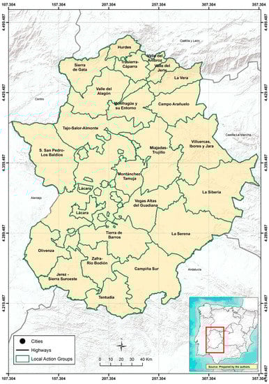
Figure 1.
Study area of Extremadura (South Western Spain). Source: authors.
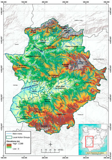
Figure 2.
Digital Elevation Model of Study area of Extremadura (South Western Spain). Source: authors.
In northern Extremadura, there are mountain regions with dispersed population in small towns that usually do not exceed 1000 inhabitants. The economic activity is based on smallholder and subsistence crops due to the physical difficulties of the territory in being agriculturally exploited. For this reason, the rich natural and historical heritage is exploited as tourist attractions. They are the regions of Sierra de Gata, Hurdes, Trasierra-Cáparra, Ambroz, and Jerte.
Further to the south, one of the main axes of the development of Extremadura is Valle del Alagón, La Vera and Campo Arañuelo. They are located in irrigated sedimentary basins with a highly established agro-industry. The regions of Monfragüe y su Entorno, Sierra de San Pedro-Los Baldíos, Montánchez-Tamuja, and Miajadas-Trujillo are next to these. These are the regions with the lowest population densities that do not exceed 10 inhabitants per km2 and have low economic development due to their poor soils and the existence of economically-unserved subsistence farming.
The most advanced areas are located in the center of the region. These are Vegas Altas del Guadiana and Tierra de Barros, where productive investments, equipment and services, and population (60% of the region) are concentrated.
In the east and southeast of the region, there are very unpopulated and traditionally isolated areas. These are La Siberia, La Serena, and Campiña Sur, which are regions where extensive cattle ranching and the exploitations of pastures and cereals are the main economic activities.
Finally, the southwest of the region is characterized by the exploitation of pasturelands and the breeding of Iberian pigs. Olivenza, Jerez-Sierra Suroeste, Zafra-Río Bodión, and Tentudía are located in this area of the region, which are traditional underdeveloped areas but have important industrial activities causing strong socioeconomic and demographic dynamics.
Consequently, studying the distribution of the rural development projects through the LEADER Approach in Extremadura is interesting because there are a great variety of territories depending upon the physical, economic, social, and demographic characteristics of each. On the one hand, there are areas with an adequate level of development, enough equipment and services, as well as an articulated, modern, and competitive agro-industrial sector. On the other hand, there are areas that are further from the main urban centers with very elderly populations and with important infrastructural deficiencies, in which the primary sector provides low incomes. Finally, there are intermediate ones with a good rural/urban interaction, whose population complement their agrarian incomes with others from the tertiary sector.
2.2. Analysis of Spatial Location
As a first methodological step, the georeferencing of more than 8300 projects subsidized through LEADER Approach in the period of 2000–2013 was carried out. Through the georeferencing, the exact location of the projects was determined from its coordinates, which informs us about the situation of the phenomenon with respect to the other areas, and in turn, associate it to places of the real world [28,29,30]. The information needed to obtain the exact location of the projects was provided by the Ministry of Agriculture, Rural Development, Environment, and Energy of the Government de Extremadura in Excel (.xls) format. In the 24 documents given, all of the projects appeared with their file number, the benefactor, the municipality, public and private participation, total investment, and by financing fund. All the information was moved to new Excel files (.xls) to work with them as a database, by adding new attributes, such as coordinates. These were obtained from Iberpix (http://contenido.ign.es/iberpix2/visor/) of IGN (National Geographic Institute), thanks to the compilation of the postal address of each project.
Secondly, three vector layers of points were created with the location of LEADER projects: one with information about total investment; a second one with the investment destined to tourism and heritage; and, a last one with the investment to SMEs (Small and Mediums Enterprises) and valorization of the agrarian production. Most of these projects are aimed at diversification towards non-agricultural activities through the creation and development of micro-enterprises. These enterprises will contribute to the expansion and modernization of these areas, encouraging a greater performance of the local economy, the promotion of tourist activities, and the creation of a product that complements the existing tourist infrastructure with the creation of information centers, museums, and so on. We analyzed these three sectors as that they are the ones with the most projects and investments.
Thirdly, the pattern analysis and distribution of the points previously obtained were performed with the ArcGIS software using the Local Moran’s I statistic, the Hot Spot analysis (Getis-Ord Gi*), and Kernel Density, as part of the set of quantitative methods that aim to identify and describe patterns of geographic distribution. These spatial statistics deal with the effects of spatial dependence and heterogeneity and incorporate location information, such as the geographic coordinates of the site (as it occurs in this paper) or the polygon of the study region [31]. On the one hand, the first two methods are effective tools for pattern analysis, measurement of geographic distributions, spatial relationship modeling, and cluster allocation [32]. On the other hand, with Kernel Density, a smooth curved surface is determined on each point using local neighborhood calculations fixed by cell blocks or pixels and a radial symmetric function [21].
The Local Moran’s I statistic verifies how much each spatial unit contributes to the formation of the general value by capturing the degree of spatial association and the heterogeneity resulting from the contribution of each spatial unit [33]. It facilitates the visual exploration of territorial groups or patterns formed according to the data of a variable that show the analyzed units of observation and the neighboring units [34]. It is calculated with the following mathematical formula:
where xi is an attribute for feature i; is the mean of the corresponding attribute; is the spatial weight between feature I and j; and:
where n is the total number of features.
The score for the statistics are computed as:
where
Firstly, Global Moran’s I statistics were calculated for each vector layer of points. The purpose is to check that there are clusteres and to reject null hypothesis (the distribution of the investments is random) by obtaining a z score and a statistically significant global P score.
After this, once the results of Global Moran’s I statistic were analyzed, the Local Moran’s I values were calculated. We decided to obtain the type of Euclidean distance relationship under the criterion of squared inverse distance, such that it is estimated that the relationship capacity decreases rapidly with discretization. In the three cases that were analyzed, P values were obtained in the clustered areas that represent the statistical significance in a code that indicates: zones with high presence of members of a group surrounded by areas with also high presence (High-High situation) and zones with high presence surrounded by units with low presence (High-Low situation). It is also possible to detect areas with low presence surrounded by units with low presence (Low-Low status) or zones with low presence surrounded by units with a high presence of the variable analyzed (Low-High situation). Finally, zones with no significant spatial association can also be detected [35]. Obviously, one of the priorities in this study is to obtain a number that can quantify the spatial cluster pattern and where clustering has been produced in the distribution of investments.
The Getis-Ord Gi* statistic [36,37] indicates whether functions with high values or low values tend to concentrate in one area of study by identifying statistically significant spatial clusters of high values (hot spots (reddish tones)) and low values (cold spots (blue tones)), with respect to the average of the sample. It evaluates each entity within the context of neighboring entities and compares the local situation with the overall situation (average investments). In this way, the Getis-Ord Gi* statistic reveals the spatial distribution pattern and the approximate spatial aggregation range [38].
The mathematical formulation is:
where is the attribute value for feature j; is the spatial weight between feature i and j; n is equal to the total of features and:
The statistic is a z-score so no further calculations are required.
In order to be considered as a statistically significant hotspot, an entity must fulfill two conditions: (1) having a high value and being surrounded by other entities with high values with respect to the average, and (2) knowing that the spatial location of entities with these characteristics reflects where the agglomerates occur and the degree of statistical confidence [18].
To complete the previous analysis, a density analysis was carried out, which takes known quantities of phenomena and expands them in the territory based on the quantity that is measured in each location and the spatial relationship between them. The Kernel Density method is one of the most accepted techniques in geography. Studies have analyzed this method from a purely mathematical and statistical perspective [20,39], but authors such as Moreno [40] and Escolano [41] have presented and systematized it in a geographical and applied way. Thus, the Kernel Density is a statistic that calculates the magnitudes of the areas where agglomerates can be produced from the sampling points or entities. Furthermore, it is a non-parametric method of estimation with which such rigid principles are not applied to the data. Therefore, it is a very convenient method to locate point concentrations based on density estimates [18].
The Kernel Density statistic is expressed by [40]:
where
- is the point at which the density is estimated;
- X1 is the value of the variable in the case i = 1…, n;
- K is the Kernel symbol;
- and H is the window width or smoothing parameter.
The Kernel Density method can be considered as a sophisticated way to calculate the intensity. The value obtained represents the result of a calculation made on several points around it, so that the points farthest from the pixel center has a lower weight in the calculation. Thus, this method generates a smooth curved surface on each studied point using local neighborhood calculations defined by cell clusters or pixels and a radial symmetric function [42]. In this way, the highest density value is given over the point and tends to decrease progressively as it moves away from it until the bandwidth, where the density value reaches 0 [43]. In this case, the concentration of projects has been calculated without taking into account the total investments. The objective is to complement the previous analyzes, in which the location of projects and the quantity of the investments has been considered.
3. Results and Discussion
The Moran’s Global I clustering results were obtained in the three analyzed variables, with a higher concentration in total investments (z = 38.34, Moran’s I = 0.10), followed Tourism and Heritage (z = 13.42, Moran’s I = 0.09), and finally by SMEs and Valorization of Agricultural Production (z = 11.9; Moran’s I = 0.35). According to the results at the local level (Moran’s Local I), groups with high values in investments were surrounded by scattered points with small investment, because the three correlations are negative with an expected I that varies between 1 and −1. The three cases have p values of 0.0.
Through these first results, we interpreted that the total investments to the Rural Development in Extremadura are not adequately distributed, homogeneous, or balanced, both at the municipal level and by LAG. All of the LAGs have executed projects, but not with the same intensity. Next, a table is exposed (Table 1) with the main indicators of LEADER in Extremadura, as well as a frequency plot in which the investments carried out are presented according to the number of projects (Figure 3).

Table 1.
Indicators of LEADER Approach (2000–2013).
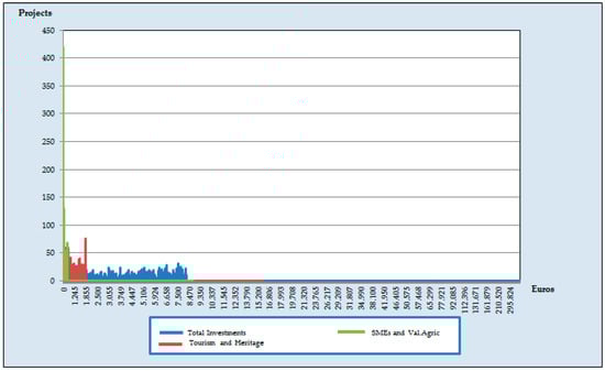
Figure 3.
Frequency plot with LEADER Approach’s investments in Extremadura (2000–2013).
According to the results of Global Moran’s I (Figure 4) and Local Moran’s I (Figure 5), there are concentrations of clusters (269) with High-High values in 75 towns (19.5%), coinciding with the most dynamic areas of Extremadura: Vegas Altas del Guadiana, Tierra de Barros, Valle del Jerte, Valle del Ambroz, and Valle del Alagón. The High-Low relationship shows 562 groups, located in the main county towns of the region with more than 5000 inhabitants. With low values (Low-Low or Low-High) 3632 groups result and they are located mainly in towns with less than 2000 inhabitants and in LAGs in the peneplain and mountains.
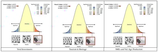
Figure 4.
Global Moran’s I of LEADER Approach (2000–2013).
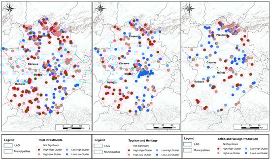
Figure 5.
Local Moran’s I of LEADER Approach (2000–2013).
Thus, there is concentration of investments in the towns in which the Rural Development Centers are located and in the most developed areas of the region, in which there are areas of irrigated land, productive vineyard, and olive cultivations, and in other areas next to the main communication routes of the region (A-66 and A-5) [1]. Hence, there is a double trend: there are towns, which are the most developed, in which the greatest number of projects is carried out, in contrast to the more ruralized and less developed economic and demographic ones, in which the projects and the amounts inverted are still limited.
As for the investments in Tourism and Heritage, there are 87 High-High concentrations in mountain areas of the north of the region, where investments have been made in projects promoting tourism, and in areas of southeast Extremadura, where the projects have been dedicated to the rehabilitation of the Cultural Heritage and the improvement of their villages. In SMEs and Valorisation of Agricultural Production, High-High values appear in Tierra de Barros and in irrigated areas of Guadiana river and Campo Arañuelo; High-Low values result in areas of Valle del Jerte, La Vera, and Valle del Ambroz, where it has invested in the revaluation and commercialization of products, such as cherry, paprika, or tobacco. However, these projects are located only in the central nuclei of the regions, so they appear with High values surrounded by Low ones. As for low values (Low-Low or Low-High), there are concentrations in smaller villages and in mountain and peneplain areas.
With regard to the results that were obtained with the Getis-Ord Gi* statistics (Figure 6) for the Total Investment variable, hotspots can be observed (units with high investments compared to the average surrounded by other ones with high investments compared to the average) in the population centers with the highest economic development and greater population. Therefore, there are 1375 hotspots (16% of the total projects) in the most urban and dynamic areas with the highest youth population. In contrast, there are concentrations of projects with a total investment below the regional average in the mountain and peneplain areas. Then, 3349 cold spots are located throughout the territory of Extremadura, but are concentrated in the same previous areas (mountain and peneplain) with physical constraints.
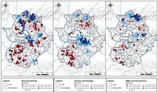
Figure 6.
Getis-Ord Gi* statistic of LEADER Approach (2000–2013).
Regarding investments in Tourism and Heritage, clusters with high values in investments in Heritage are located in the southeast of the region, in Campo Arañuelo and in Hurdes, where the projects are dedicated to expanding rural housings and other complementary tourist offers. On the other hand, in Olivenza, Lácara, Jérez-Sierra Suroeste, Zafra-Río Bodión, and Tierra de Barros, most of the projects are related to the rehabilitation and improvement of the villages. Besides, groups with low values are located in irrigated areas of Vegas Altas del Guadiana and in the peneplain of nothern province of Cáceres (Montánchez-Tamuja, and Miajadas-Trujillo) and in the southern province of Badajoz (La Serena and Campiña Sur). The investments in these county towns are related to SMEs and agriculture in the case of Vegas Altas del Guadiana, La Serena, and Campiña Sur.
The county towns with high values in relation to the average in SMEs and Valorization of Agricultural Production, appear in the most dynamic areas with respect to the sectors analyzed again (260 Hot Spots). However, greater concentration with low values is located in territories where the investments below the average (440 points with Low-Low). The average is 83,363 Euros and its deviation is 125,473.
50% of the projects do not exceed 35,000 Euros, and there are only 40 projects with more than 500,000 Euros (the maximum is 1,630,250 Euros). This shows even greater contrasts than in the Tourism variable and in Total Investments.
In this way, this index accentuates and strengthens the results that are obtained with the first calculated statistic of Moran’s I.
As a corollary, the Kernel densities mapping (Figure 7) for the variables analyzed shows practically the same results. We observed that the highest concentration of projects is located in the towns that acts as county seat and where the rural development center of each LAG is placed. Nevertheless, not all of these most developed towns have the same volume of investments. The amounts are greater in the LAGs that have allocated their aid to SMEs projects and revaluation of agricultural production. On the contrary, projects that are related to tourism or heritage rehabilitation, although they are numerous, have a lower economic value. Therefore, High-High values in Local Moran’s I or hotspots in Getis-Ord Gi* do not appear in these areas.
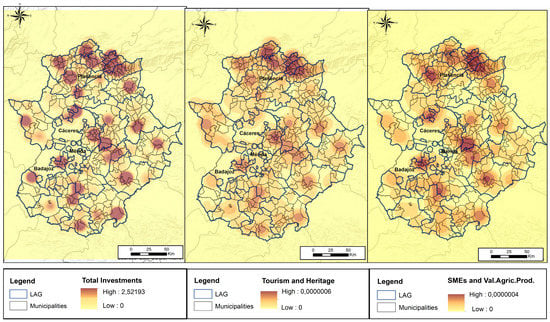
Figure 7.
Kernel densities of LEADER Approach in Extremadura (2000–2013).
The typology of the projects is different. There are more projects (3163) in Tourism and Heritage, but with less investment; the average value is 58,894 Euros in Tourism and 30,661 in Heritage. In contrast, in SMEs and Valorization of Agricultural Production, there are fewer projects (2630), but with greater investment, with an average of 77,438 Euros in SMEs and 100,065 Euros in in the second one.
Economic and demographic indicators are featured below in Figure 8 to see whether the concentration of investments are achieving the expected results. In the demographic aspect, LAGs of the North of the region present an Old-Age Index, with average rates that are superior to 30%, in contrast with the most dynamic areas of the region, which have an average rates of 20%, as the cases of Vegas Altas del Guadiana, Tierra de Barros, and Campo Arañuelo (Figure 8). At the same time, these groups present the most alarming values in population loss, with negative growth rates in the period of 2011–2015 (only the towns with more urban characteristics and located mainly in Campo Arañuelo, Olivenza, Lácara, Tierra de Barros, and Vegas Altas del Guadiana increase their population).
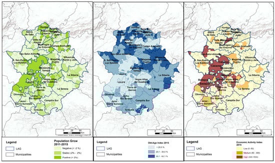
Figure 8.
Demographic and Economic indicators of Extremadura (2011–2015).
Therefore, it can be assumed that the investments destined to Tourism and Heritage have little economic impact and generate few synergies, reason why they are not achieving the expected socioeconomic and demographic results in the Northern and peneplain areas of the Extremadura region. This is because the tourist activity has been taken as the only economic activity by the employer and not as a complement to the agrarian, artisan, or industrial incomes as the European Union recommend. The activities carried out still do not attract enough tourists, as well as do not build adequate facilities and the necessary employment to create synergies that allow for the takeoff of the most rural areas. On the contrary, some investments in SMEs and to the improvement of the agrarian sector are able to generate larger projects that create a greater number of jobs and economic benefits.
It can be seen that through the three spatial analysis methods used, the same results have been obtained, although they complement each other. Thus, the initial hypothesis can be confirmed and accepted, which states that there is an excessive location of investments in the most dynamic territories of the region.
4. Conclusions
In this paper, all of the projects that have been financed with the LEADER Approach in the two last programming periods (2000–2006 and 2007–2013) have been analyzed as well as their territorial distribution based on the amounts invested since their geolocation. The pattern analysis has been used to check to what extent the distribution of rural aids is equitable for the whole territory. For this, three variables have been analyzed from the local spatial localization statistics: Moran’s I, Getis-Ord Gi*, and Kernel Density. The variables are: Total investment, Investment in Tourism and Heritage and Investment in SMEs, and Valorization of Agricultural Production.
In this way, when considering the results previously exposed, certain trends in the territorial distribution of investments can be identified. There is a clear concentration of total investments in the main regional towns of the region, which are those with greater demographic and socio-economic dynamics. These areas act as the functional centers of the different counties and are where the rural development centers are located (in these centers, the technicians who manage the rural development aid work). In contrast, areas with a more dispersed distribution of investments have been identified in mountainous areas, peneplain, and in the southeast of Extremadura. These areas have the smallest populations, form borders with other countries, and are far from the main communication routes. Therefore, they are also far from the main population centers with the highest economic activity, population, and consumption.
In terms of tourism and heritage, there is a greater tendency to invest in the north of the region, especially when considering areas where it has not been possible to develop a competitive agriculture that facilitates economic autonomy due to various physical difficulties. Thus, several LAGs in these areas rely on exploiting existing natural and historical resources, as well as the support and promotion of tourism products: denominations of origin, regional and national tourist interest parties, folklore, crafts, gastronomy, and so on. In this sense, in these areas, the commitment to activities in the service sector is minor when compared to cases in the center and south of the region, where there are two trends: on the one hand, there are county towns with tertiary activities still close to the agrarian one, and on the other hand, there are historical counties with an important economic activity due to its proximity to the main cities of the region in some cases (Badajoz and Mérida). In these last areas, LAGs rely on investing in the service and agrarian sectors, which, with a smaller number of projects than those dedicated to Tourism and Heritage, are generating more development by investing larger amounts in more ambitious projects. In the most aging and unpopulated areas, the initiatives are numerous but have very small economic value and generate short activity.
In such a way, it can be determined that LEADER will not give the expected results in areas with a small business base, and particularly, agro-industrial areas. This is due to the lack of initiatives or new projects, despite the great effort made by the LAGs. The dependence of entrepreneurs on the “new” way of understanding developments in major investments being concentrated in the towns that are already the most dynamic, leaving out those who really need initiatives, such as LEADER and where the Old-age and Population Grow rates and Economic Activity Index are the worst. The “most powerful” and economically solvent actors continue to be the ones with the greatest capacity to develop new projects in towns where developing new businesses is profitable since there is enough young population to face the economic activity and jobs that are created.
Despite the above, everything that has been done by the LAGs of Extremadura cannot be ignored, as they have faced many difficulties, such as the effects of the current economic crisis, which has held back investments by the entrepreneurs, and the delays in the execution of the last program (rural development aids began to be offered three years after the start of the program due to administrative difficulties with the EU). Despite this, methodologies such as LEADER remain primordial, taking into account their great contribution in the settlement of the rural population in various areas, in the consolidation of their culture and idiosyncrasy, in the improvement of social services, in the promotion of measures of equality and social inclusion, and so on. This is conducted all in order to achieve the goal pursued since the early 1990s, which is a rural environment where the quality of life of its inhabitants prevails and where it is possible to reverse the processes of depopulation and aging.
Acknowledgments
This research was backed by the General Secretary of Science, Technology, and Innovation of the Government of Extremadura under the grant for PhD Training Research PD12028, co-financed by ESF (European Social Fund) and ERDF (European Fund for Regional Development) funding under grant GR15121 to cover the open access publication costs. This support is gratefully acknowledged.
Author Contributions
Ana Nieto Masot and Gema Cárdenas Alonso conceived and designed the experiments; both authors performed the experiments, analyzed the data, contributed analysis tools and wrote the paper.
Conflicts of Interest
The authors declare no conflict of interest. The founding sponsors had no role in the design of the study, in the collection, analyses or interpretation of data, in the writing of the manuscript and in the decision to publish the results.
References
- Nieto Masot, A.; Cárdenas Alonso, G. El método leader como política de desarrollo rural en extremadura en los últimos 20 años (1991–2013). Bol. Asoc. Geógr. Esp. 2015, 69, 139–162. [Google Scholar]
- Atance Muñiz, I.; Tió Saralegui, C. La multifuncionalidad de la agricultura: Aspectos económicos e implicaciones sobre la política agraria. Rev. Esp. Estud. Agrosoc. Pesq. 2000, 189, 29–48. [Google Scholar]
- Cebrián Abellán, A. Génesis, método y territorio del desarrollo rural con enfoque local. Papeles Geogr. 2003, 15, 38. [Google Scholar]
- Cárdenas Alonso, G.; Nieto Masot, A. Towards rural sustainable development? Contributions of the eafrd 2007–2013 in low demographic density territories: The case of extremadura (sw spain). Sustainability 2017, 9, 1173. [Google Scholar] [CrossRef]
- Gabbrielli, E.; Riccioli, F.; Casini, L. The impact of agro-environmental policies in tuscany. Sci. Reg. 2017, 16, 433–462. [Google Scholar]
- Jaraite, J.; Kažukauskas, A. The effect of mandatory agro-environmental policy on farm environmental performance. J. Agric. Econ. 2011. [Google Scholar] [CrossRef]
- Marconi, V.; Raggi, M.; Viaggi, D. Assessing the impact of rdp agri-environment measures on the use of nitrogen-based mineral fertilizers through spatial econometrics: The case study of emilia-romagna (Italy). Ecol. Indic. 2015, 59, 27–40. [Google Scholar] [CrossRef]
- Ziolkowska, J. Impact of environmental objectives on optimal budget al.locations for agro-environmental measures-a case study for Poland. Agric. Econ. Res. Rev. 2010, 23, 233–244. [Google Scholar]
- Esparcia Pérez, J. Evolución reciente, situación actual y perspectivas futuras en el desarrollo rural en españa y en la UE. Rev. Maroc. Adm. Locale Dév. 2012, 31, 53–84. [Google Scholar]
- Solsona, J.; López, D. Factores de localización y desarrollo turístico en el espacio rural de la comunitat valenciana. Bol. Asoc. Geógr. Esp. 2012, 212, 221–244. [Google Scholar]
- Nieto Masot, A.; Cárdenas Alonso, G. 25 years of the leader initiative as european rural development policy: The case of extremadura (sw spain). Eur. Ctry. 2017, 9, 302–316. [Google Scholar] [CrossRef]
- Delgado Viñas, C.; De la Fuente Royano, M.T. Las Estrategias de Desarrollo rural: Una Valoración del Proder en Cantabria, Los Espacios Rurales en el Cambio de Siglo: Incertidumbres ante los Procesos de Globalización y Desarrollo, Lleida, 2000; Asoción de Geógrados Españoles; Departamento de Geografía y Sociologúa de la Universidad de Lleida: Lleida, Spain, 2000; pp. 723–734. [Google Scholar]
- Navarro, F.; Cejudo, E.; Maroto, J.C. Reflections on participation in rural development. Social distribution or strengthening of power? Leader and proder in southern spain. EURE 2014, 40, 75–91. [Google Scholar]
- Iakovidou, O.; Koutsouris, A.; Partalidou, M. The development of rural turism in greece, through the inictiative leader ii: The case of northern and central chalkidiki. New Medit 2002, 1, 32–38. [Google Scholar]
- Osti, G. Leader and partnerships: The case of Italy. Sociol. Rural. 2000, 40, 9. [Google Scholar] [CrossRef]
- Marquardt, D.; Möllers, J.; Buchenrieder, G. Social networks and rural development: Leader in romania. Sociol. Rural. 2012, 52, 398–431. [Google Scholar] [CrossRef]
- Lukic, A.; Obad, O. New actors in rural development—The leader approach and projectification in rural Croatia. Sociol. Space 2016, 54, 71–90. [Google Scholar] [CrossRef]
- Galacho Jiménez, F.B. Estimación de pautas de asociación y patrones de distribución de edificaciones aisladas en espacios rurales mediante sig y técnicas basadas en procesos puntuales. In Proceedings of the XXIV Congreso de la Asociación de Geógrafos Españoles, Zaragoza, Spain, 28–30 October 2015. [Google Scholar]
- Ordóñez Galán, C.; González Varela, M.; Reyes Pantoja, A. Desarrollo de un sig para el análisis de patrones espaciales de incendios en viviendas. Geofocus Rev. Int. Cienc. Tecnol. Inf. Geogr. 2011, 1–18. [Google Scholar]
- Brunsdon, C. Analysis of Univariate Census Data; CensusUsers HandBook; GeiInformation International: Cambridge, UK, 1995; pp. 213–238. [Google Scholar]
- Guerra, O.D.C. Valoración del método de densidades focales (kernel) para la identificación delos patrones espaciales de crecimiento de la población en españa. GeoFocus 2004, 4, 136–165. [Google Scholar]
- Buzai, G.D.; Baxendale, C.A. Análisis socioespacial con sistemas de información geográfica marco conceptual basado en la teoría de la geografía. Cienc. Espac. 2015, 8, 391–408. [Google Scholar] [CrossRef]
- Moreno Jiménez, A.; Fuenzalida Díaz, M. Medición y cartografía del impacto socialmente percibido ante industrias contaminantes con un estimador de densidad núcleo (kernel) y sig: Aplicación al caso del complejo industrial ventanas, chile. Estud. Geogr. 2017, 78, 225–256. [Google Scholar] [CrossRef]
- Ding, L.; Chen, K.-L.; Liu, T.; Cheng, S.-G.; Wang, X. Spatial-temporal hotspot pattern analysis of provincial environmental pollution incidents and related regional sustainable management in china in the period 1995–2012. Sustainability 2015, 7, 14385–14407. [Google Scholar] [CrossRef]
- Habibi, R.; Alesheikh, A.A.; Mohammadinia, A.; Sharif, M. An assessment of spatial pattern characterization of air pollution: A case study of co and pm2. 5 in Tehran, Iran. ISPRS Int. J. Geo-Inf. 2017, 6, 270. [Google Scholar] [CrossRef]
- Bathrellos, G.D.; Gaki-Papanastassiou, K.; Skilodimou, H.D.; Papanastassiou, D.; Chousianitis, K.G. Potential suitability for urban planning and industry development using natural hazard maps and geological–geomorphological parameters. Environ. Earth Sci. 2012, 66, 537–548. [Google Scholar] [CrossRef]
- Bathrellos, G.D.; Skilodimou, H.D.; Chousianitis, K.; Youssef, A.M.; Pradhan, B. Suitability estimation for urban development using multi-hazard assessment map. Sci. Total Environ. 2017, 575, 119–134. [Google Scholar] [CrossRef] [PubMed]
- Beltrán, G. La geolocalización social. Polígonos. Rev. Geogr. 2015, 27, 97–118. [Google Scholar] [CrossRef]
- Hill, L.L. Georeferencing: The Geographic Associations of Information; MIT Press: Cambridge, MA, USA, 2009. [Google Scholar]
- Velazco, S.; Joyanes, L. In La geolocalización al servicio de la sociedad. In Proceedings of the X Congreso TopCart 2012—I Congreso Iberoamericano de geomática y C.C. de la Tierra, Madrid, Spain, 16–19 October 2012. [Google Scholar]
- Clemente, A.M.; Júnior, O.A.C.; Guimarães, R.F.; McManus, C.; Turazi, C.M.V.; Hermuche, P.M. Spatial-temporal patterns of bean crop in brazil over the period 1990–2013. ISPRS Int. J. Geo-Inf. 2017, 6, 107. [Google Scholar] [CrossRef]
- Hair, J.; Anderson, R.; Tatham, R.; Black, W. Análisis Multivariado de Datos, 5th ed.; Pearson Prentice Hal: Madrid, Spain, 2008. [Google Scholar]
- Celemín, J.P. Autocorrelación espacial e indicadores locales de asociación espacial: Importancia, estructura y aplicación. Rev. Univ. Geogr. 2009, 18, 11–31. [Google Scholar]
- Iris, P. Los métodos de autocorrelación espacial para la regionalización intraurbana. In Teoría y Métodos de la Geografía Cuantitativa; Buenos Aires, M.L., Ed.; MCA Libros: Buenos Aires, Argentina, 2015; pp. 139–154. [Google Scholar]
- Anselin, L. Local indicators of spatial association—Lisa. Geogr. Anal. 1995, 27, 93–115. [Google Scholar] [CrossRef]
- Getis, A.; Ord, J.K. The analysis of spatial association by use of distance statistics. Geogr. Anal. 1992, 24, 189–206. [Google Scholar] [CrossRef]
- Ord, J.K.; Getis, A. Local spatial autocorrelation statistics: Distributional issues and an application. Geogr. Anal. 1995, 27, 286–306. [Google Scholar] [CrossRef]
- Qin, J.; Yu, G.; Xia, T.; Li, Y.; Liang, X.; Wei, P.; Long, B.; Lei, M.; Wei, X.; Tang, X. Spatio-temporal variation of longevity clusters and the influence of social development level on lifespan in a chinese longevous area (1982–2010). Int. J. Environ. Res. Public Health 2017, 14, 812. [Google Scholar] [CrossRef] [PubMed]
- Bailey, T.C.; Gatrell, A.C. Interactive Spatial Data Analysis; Longman Scientific & Technical: Essex, UK; New York, NY, USA, 1995; Volume 413. [Google Scholar]
- Moreno Jiménez, A. Modelización Cartográfica de Densidades Mediante Estimadores Kernel. Treballs de la Societat Catalana de Geografia 1991, 30, 155–170. [Google Scholar]
- Escolano Utrilla, S. El desequilibrio del modelo territorial de la población aragonesa. In Algunas Implicaciones a propósito del Plan Integral de Política Demográfica; V. PINILLA y LA SÁEZ (Coords.): Despoblación y políticas públicas en Aragón; Gobierno de Aragón: Zaragoza, Spain, 2002; pp. 97–117. [Google Scholar]
- Yu, W. Identifying and analyzing the prevalent regions of a co-location pattern using polygons clustering approach. ISPRS Int. J. Geo-Inf. 2017, 6, 259. [Google Scholar] [CrossRef]
- Smith, M.J.; Goodchild, M.F.; Longley, P. Geospatial Analysis: A Comprehensive Guide to Principles, Techniques and Software Tools; Troubador Publishing Ltd.: Leicester, UK, 2007. [Google Scholar]
© 2018 by the authors. Licensee MDPI, Basel, Switzerland. This article is an open access article distributed under the terms and conditions of the Creative Commons Attribution (CC BY) license (http://creativecommons.org/licenses/by/4.0/).