Article

The Solomonic Districts and the Nimshide Dynasty Administrative System in the Southern Levant

Institute of Christianity and Korean Culture, College of Theology, Yonsei University, Seoul 03722, Republic of Korea
Religions 2023, 14(5), 598; https://doi.org/10.3390/rel14050598
Submission received: 28 February 2023 / Revised: 27 April 2023 / Accepted: 29 April 2023 / Published: 2 May 2023
(This article belongs to the Section Religions and Theologies)

Abstract

:
Scholars once eagerly claimed that 1 Kgs 4:7–19 contains historical information and represents a reliable source of information on David and Solomon’s administrative system. However, with the idea of a great United Monarchy becoming controversial since the 1990s, some pivotal studies have proposed new dates for this list’s composition, ranging from the 10th, mid-ninth, early eighth, and mid-seventh centuries BCE to even the post-exilic period. This article begins with the premise that 1 Kgs 4:7–19 represents the political reality of a specific time period, which could leave traceable factual evidence. Synthesizing topographical-textual, archaeological, and historical observations of 1 Kgs 4:7–19 to elucidate its likely historical background results in an inference suggesting early eighth century BCE composition during the reigns of Joash and Jeroboam II.

1. Introduction

1 Kgs 4:7–19 describes Solomon’s twelve districts and their ‘appointed prefects’ (נצבים: i.e., provincial governors, Frevel 2016, p. 121), each responsible for supplying monthly necessities to the royal families. Several convoluted topographical and geographical issues observed in this section have been somewhat resolved by numerous crucial works providing a relevant Sitz im Leben. Yet some key anomalies remain unresolved and continue to perplex scholars. First, a rambling mixture of anonymous (vv. 8, 9, 10, 11, 13) and specified/named (vv. 12, 14–19) patronymics of prefects introduces each district (Reis 2008, pp. 261–66) second, a combination of names of tribes and districts is problematic from many angles; third, theophoric name usage (יהו- or -יוהו) is relatively rare, whereas the specific prefix type אבי or אחי appears frequently; fourth, the absence of ‘Judah’ and the duplication of ‘the land of Gilead’ (vv. 13, 19) are so abstruse that several scholars have considered them to be textual emendations; finally, some biblical historians have called for a reevaluation of the Solomonic kingdom’s territory since the list differs from what 1 Kgs 5:1, 4–5 [4:21, 24–25], and 8:65 portray about Solomon’s realm signifying the boldest vision of Great Israel.
Following Alt’s groundbreaking work on the district system and the topographical survey (Alt 1953), scholars once eagerly claimed that 1 Kgs 4:7–19 contains historical information, considering it a reliable source of knowledge on the administration during David’s and Solomon’s rule (Wright 1967; Ottosson 1969, pp. 219–20; Mettinger 1971, pp. 117–27; Aharoni 1979, pp. 309–20; Bright 1976; Kallai 1986, pp. 40–72; Niemann 1997; Kamlah 2001). Textual analyses evaluated (1) whether the biblical account mentions ancient tribal boundaries that Solomon may have maintained, (2) his political shift that constituted provincial entities, or (3) his administrative system of duties collection and tax (Alt 1953, p. 88; Wright 1967, p. 59). Since the 1980s, there has been a burgeoning tendency among skeptical biblical historians to reject the notion of the great United Monarchy of David and Solomon (e.g., Lemche 1988, pp. 139–43; Thompson 1992, pp. 312–13). Neither 10th century scribal activities in royal courts nor extra-biblical evidence for extensive writing in Jerusalem and the Judean Highlands can prove that a centralized political authority therein existed prior to the first half of the ninth century BCE (e.g., Finkelstein and Sass 2013, 2017). Thus, there is seemingly no textual evidence of the relevant development of social complexity in settlement patterns, an urbanization process, an administrative system, or a social hierarchy established in the 10th century BCE. Recognizing this problem, some pivotal studies have proposed a new dating for the list, suggesting the early-ninth century BCE (Knauf 1991, p. 178; 2016, pp. 166–67), the mid-ninth century BCE (Gilboa et al. 2015), early eighth century BCE (Finkelstein and Silberman 2006, pp. 141–42; Finkelstein 2013, pp. 108, 131; 2017, pp. 285–86), mid-seventh century BCE (Na’aman 2001), or post-exilic composition of Deuteronomistic Historians (DtrH) with the orally transmitted pre-DtrH material (Ash 1995). Particularly questioning the list’s historical validity, Ash’s nihilistic approach regards the list as a utopian map of the ideal monarchy for the Persian Judeans. However, there is no literary or historical evidence to accept that the list is more fictional than a historical reflection of a ruled territory. As the list itself describes, it is reasonable to assume that the historian(s) drew the geographic details with the administrative elements, such as the listed districts and tribes, and the names of prefects on the basis of the political reality of the historians’ own time. Based on this premise, recent studies (Faust 2021; Keimer 2021; Garfinkel 2021; Mazar 2021; Ortiz and Wolff 2021) reassess state formation processes as the political development during the Iron Age I-II. Thus, the argument once again emerged that the 10th century Jerusalem–based polity emerged and expanded following the biblical descriptions related to David and Solomon.
Taking this current scholarly discourse into consideration, this article seeks a multidisciplinary evaluation of 1 Kgs 4:7–19, a biblical account of Solomon’s territory. The intent is to thus present a case study of a method whereby a given text’s likely historical background can be identified. This study highlights intricate unresolved problems posed by previous works and analyzes them using textual–topographical, archaeological, and historical observations. This integrated analysis renders a relevant inference about the dating of 1 Kgs 4:7–19.

2. Topographical-Textual Analysis of 1 Kgs 4:7–19

This section will offer a textual-topographical analysis by deducing information from the list. The present list includes information about not only each cited locality but also each district and its implied borders. These two points are pivotal in suggesting a historical setting for the list in relation to textual-topographical, archaeological, and historical approaches. Topographical issues in each district will be reviewed first in the order of textual presentation (see Table 1).
The aforementioned topographical considerations demonstrate the following noticeable elements as illustrated in Figure 1.
First, District I (Ephraim) and District III (Land of Ḥepher) comprise two pivotal central highland districts. Second, in terms of geographical proximity, as bordering districts, the two districts extend to District V’s southern border (Jezreel Valley and central Jordan Valley) and to District XI’s northern border (Benjamin). Third, District VI (northern Gilead and Part of Bashan) encompasses the Transjordan areas north of the Jabbok River, including the entire Golan Heights, bordering on the modern Arabic villages El-Lejah and Jebel Druz. District XII (Southern Gilead and Part of Bashan) has dominion over two regions since the land of Siḥon is compatible with the tribal territory of Gad, perhaps including Reuben (Josh 13:15–28 in light of Num 21:27–30; 32:33–38), and the land of Og is equated with Gilead and part of Bashan, the half of the traditional Manasseh (Josh 13:27, 30): (1) the Ḥeshbon area, north of Nebo and south of District VI, and (2) the southern Gilead area to the south of Jabbok River. District VII (Maḥanaim area) includes a limited condensed territory between two District XII areas. Fourth, the three tribal districts VIII, IX, and X accord well with the northern Galilee region, lying west of the upper Jordan River and Lake Kinneret/Sea of Galilee. Districts VIII and IX extend from Naphtali up to the Litani River in the north and Asher in the western mountainous Galilee, southeast of Tyre and Sidon. District X, the land of Issachar in eastern Lower Galilee, lies south of Districts VIII and IX (Gal 1992).
Judah’s absence in 1 Kgs 4:7–19 demands analysis. One suggestion is that ‘all Israel’ in 1 Kgs 4:7 might convey the author’s intention that the list represented the concrete image of Israel and Judah as a whole. Alternatively, the list’s closing item, District XII, might be a different designation of Judah. Others view 1 Kgs 4:19a as a doublet of District VI, explaining the identity of ארץ among ‘ונציב אחד אשר בארץ’ as Judah (Albright 1925, pp. 25–27, 34; Mettinger 1971, pp. 121–22; Cogan 2001, p. 211; Na’aman 2001, p. 422). Another suggestion is that the name ‘Judah’ was actually mentioned at the end of v. 19 but was erased due to haplography in v. 20a and that it therefore should be considered a ‘normalizing gloss.’17 Na’aman (2001, p. 432) suggests that גבר בן אורי was original, meanwhile arguing that the long sentence ‘בארץ גלעד ארץ סיחון מלך האמרי ועוג מלך הבשן ונציב אחד’ was a later interpolation. Other scholars opine that ‘נציב אחד אשר בארץ (יהודה)’ was a secondary addition (Alt 1953, pp. 88–89; Aharoni 1979, p. 309; Ash 1995, p. 77). Note that the נציב usage only appears in post-exilic texts (1 Chr. 11:16; 18:13; 2 Chr 8:10; 17:2); thus, נציב with הארץ (the land [of Judah]) is secondary. These arguments demonstrate the difficulties associated with 1 Kgs 4:19.
All attempts to equate District XII with Judah must tackle the inexcusable absence of the overt designation of ‘Judah’ in the main text of the twelve administrative divisions (vv. 7–19) without interior evidence to reconstruct it and taking the liberty to assume textual emendation with no surface problem points to its omission. Most problematic is the fundamental premise that ‘All Israel (v. 7)’ should include both ‘Judah and Israel (as stated in v. 20)’ and that the original list perhaps featured Judah after District XI. As the omission of Judah in vv. 7–19 and the insertion of ‘Judah and Israel’ in v. 20 may trigger doubts about Judah’s political status as a central district; if Jerusalemite royal scribes composed 1 Kgs 4:7–19, how could they have accidentally omitted it? Furthermore, it is worth noting that according to the literary corpus from Joshua to Kings, the usage of the word ‘All Israel’ is usually restricted to denote the Northern Kingdom of Israel. It is hence more reasonable to attribute the omission to the possibility of a northern Israelite writer, uninterested in Judah, leaving it out deliberately or simply lacking data.
The combined weight of these considerations suggests the following conclusion: Judah was not part of the original list. Therefore, the list is unlikely to have reflected either the United Monarchy’s territory with its capital city Jerusalem and with Judah or the Kingdom of Judah’s territory, including its political centers rooted therein.
Seeing the list as a Northern Kingdom administrative district system map makes the following points more relevant. District I—Ephraim and District III—Land of Ḥepher, the main part of Manasseh, now stand out as crucial areas in the list as these two districts always lay at the heart of the Northern Kingdom. It is now understandable why relatively detailed geographical information and city names appear only for Districts V and VI, as the author presumably wished to express their significant strategic role in and for northern Israel, enabling control over the important Via Maris and King’s Highway trade routes. The somewhat overlapping information on Districts VI and VII, covering Gilead and Bashan in Transjordan, appear together. Given that the Omride and the Nimshide rulers fought a series of battles against Aram-Damascus in the ninth—early eighth century BCE to secure its political and economic hegemony over the Transjordan area, the author understandably pays more attention to these two districts. As the three northern Galilee districts south of Tyre and Sidon were always affiliated with the Northern kingdom, they were simply reported on more. Moreover, notwithstanding the disputable affiliation of Districts II and XI, most districts were seemingly under Northern Kingdom territory up to Samaria’s fall.
The textual and topographical analysis conducted thus far, explaining each district’s borders, and identifying the enumerated cities, supports viewing the list as an administrative system map of the northern Israelite kingdom.

3. Archaeological Considerations

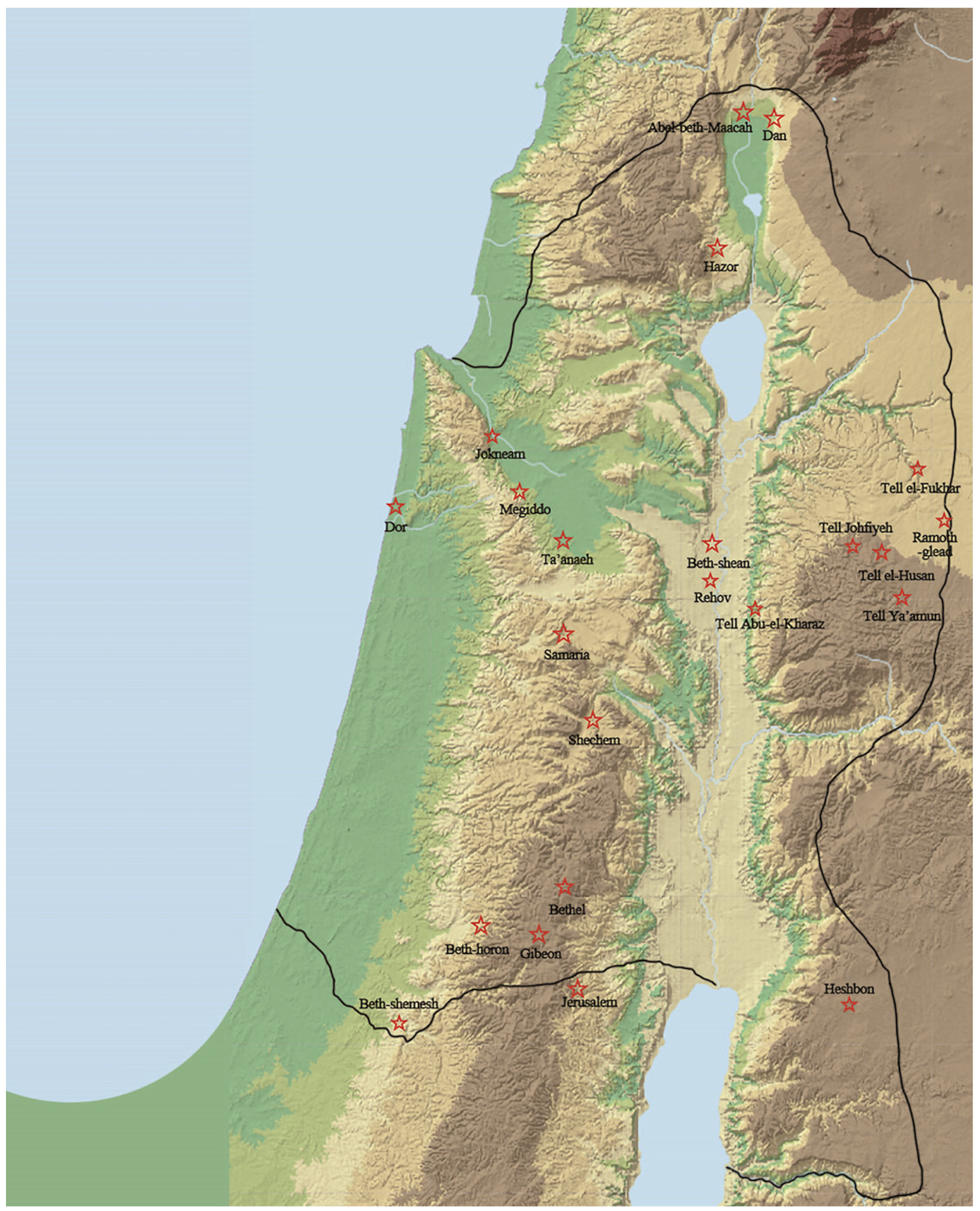
3.1. Listed Cities’ Settlement History

What else could further illuminate the list’s historical background? Let us now examine if the list offers a good case for employing archaeological data to date itself. This could be analyzed by investigating the occupation profile of the listed cities and territorial regions. This section excludes currently unidentified sites, focusing only on sites with widely accepted archaeological identifications based on excavation projects or intensive surveys.
Before proceeding, it must be noted that even a skeptical scholar like Ash (1995, 67–86) argues that since the list includes pre-DtrH sources from the archive of the royal court, it could not have been created in the exilic and post-exilic periods. Therefore, in evaluating settlement history, each site’s occupation profile is first dated to a specific era ranging from the late 10th century BCE to the late seventh century BCE. The following table (Table 2) presents a settlement history summary by site.
Based on this data, it could be argued that the early Iron IIA and Iron IIC periods cannot shed light on the authentic historical background of the list; however, it is archaeologically convincing to date the list to the late Iron IIA or Iron IIB. Some of the listed early Iron IIA cities, such as Dor (Phoenician features), Megiddo, and Jezreel (pre-Enclosure), were neither under the Israelite hegemony nor were they well-fortified centers usable for administrative purposes. Due to the poor or meager settlement activities in Beth-Shemesh, Ta’anach, Beth-Shean, Jezreel, and Ramoth-Gilead during the Neo-Assyrian period, dating this list to the seventh century BCE is archaeologically untenable. However, since recent studies try to reaffirm the paradigm of the list’s Solomonic administrative system, the late 10th–early ninth centuries/early Iron IIA should be reexamined here. In addition, since the clearly identified and excavated centers examined above cannot represent the list’s whole territory, the listed territories must be studied as a whole. To objectively assess potential periods of origin, this article will herein examine other crucial sites within each district that played vital roles in ancient Israel’s history while excluding the Iron IIC setting possibility.

3.2. Can the List’s Setting Be Early Iron IIA (10th Century BCE)?

Archaeologists applying ‘the Modified Conventional Chronology’ (e.g., Mazar 2010; 2011; Dever 2017, pp. 259–382; Faust 2021) to the Southern Levant Iron Age opine that the political entity rooted in Jerusalem in the 10th century BCE might have had enough centralized capacity to rule the entire territorial extent mentioned in the text. Crucial settlement history studies that might support the above argument analyze the following areas: Shephelah, Sharon Plain, Jezreel Valley, Jordan Valley, Lower Galilee, and Gilead (Faust 2021; Keimer 2021; Garfinkel 2021; Mazar 2021; Ortiz and Wolff 2021). However, a close examination of their occupation profiles demonstrates that their conclusions cannot be accepted, even though a ‘Low Chronology’ perspective has not been employed in this article.
First, archaeological study of the fourth Solomonic district cannot provide a firm clue for its political and territorial affiliation to a 10th century BCE Israelite kingdom: Dor and its environs do not represent the Israelite material culture. Most of District IV’s Sharon Plain, north of the Yarkon River, was rarely inhabited at that time as it was a marshy, ecologically fringe area. Further, there is no clear evidence to prove economic and cultural connections between the coast and the highlands at this period. These considerations prevented the excavators of Dor, Na’aman, and even Dever from firmly concluding that the Jerusalem polity controlled the area north of the Yarkon River (Gilboa et al. 2015; Na’aman 2016; Dever 2017, p. 290).
The same holds true for the remains excavated from the pivotal Upper and Lower Galilee sites. Vast quantities of unearthed imported Cypriot Black-on-Red I–II and Geometric I–III wares meant Asher’s territory was not directly under Israelite control. In addition, local Phoenician ‘red-slipped,’ polished, and bichrome wares indicate Naphtali was controlled by local Canaanite city-states or indirectly influenced by the neighboring Phoenician (Finkelstein 2002, pp. 124–26; contra Gal and Alexandre 2000, pp. 8–24, 120, 149–50). Yet, there appear to be insufficient quantities of local pottery sherds defined as Iron IIA Israelite pottery. Given these two elements, the ‘strong echoes’ of Phoenician material culture and the ‘meager’ Israelite finds (even considering possible robust Israelite–Tyre trade; see Ben-Ami 2004, pp. 202–3), it can be argued that contrary to the list’s representation, prior to the mid-ninth century BCE, these areas were dominated by the local northern Canaanite city-states or closely connected with the Tyrian city-states. (Frankel et al. 2001). In addition, the northwestern coastal area and the Upper Galilee would have had very little contact with Israel or Judah during the 10th century BCE. 10 out of 13 sites in the Meron ridges, and eight out of 25 sites in the Upper Galilee region (e.g., Karmiel, Khirbet Avot, Sasa, Har Adir, Har Ḥarashim, and ‘Ein el-Hilu) were abandoned at the beginning of the Iron IIA (Katz (2021) and Lehmann (2021)). Thus Katz (2021, p. 195) and Lehmann (2021, p. 302) conclude that ‘the destruction of Iron Age I towns and the abandonment of rural settlement’ may be associated with ‘Tyre’s enhanced strength’ and ‘a renewal of Phoenician domination’ over the western Upper Galilee during the Iron IIA (Frevel 2016, p. 147). Moreover, Lower Galilean sites such as el-Wawiyat and Tel ‘En Zippori (Dessel 1999) were not only abandoned in the Iron IIA but were also destroyed. Furthermore, other sites west of Lake Kinneret, such as Tel Kinrot (Münger et al. 2011), Tel Rekhesh (Paz et al. 2010), and Tel Dover (Golani and Wolff 2018) were also entirely or partially destroyed. The combination of the prevalence of Phoenician material culture and the absence of settlement in many northern and southern Galilee sites preclude accepting Solomonic rule over this region.
Third, it is problematic to regard the Gilead, Bashan, and Huldah Valley settlement patterns as evidence of the Solomonic administrative system. Aramean material culture was predominant across the region east of Lake Kinneret (Bethsaida 6a–b, Tel Hadar II, and En-Gev V–IV; Kleiman 2019, pp. 298–313). An Aramean enclave, whose remains continued to exist between Iron I and II without a gap, developed in areas around Lake Kinneret, likely dominated by the kingdom of Geshur (Na’aman 2012, pp. 88–101). In addition, the recent excavation project carried out by the Israel Antiquities Authority at Haspin on the Golan Heights reveals an 11–12th century fortification complex, probably built by the kingdom of Geshur (Tzin and Bron 2022). Second, other crucial sites’ material culture is controversial—Tell er-Rumeith (Finkelstein et al. 2013; Barako and Lapp 2015, pp. 189–91), Tell Zira’a (Häser et al. 2016), Tell al-Ḥusn (Herr 2012, p. 219), Tel Abel Beth-Maacah (Yahalom-Mack et al. 2018), Tel Dan, Tel Tannim, Tel Anafa (Kleiman 2019, pp. 272–92), and Kiryat Shmona South (Covello-Paran 2012). Their administrative building structures were apparently fortified in this period. Of course, it is not possible to directly identify Aramaean material culture since the remains do not bear clear Aramean ethnicity markers. However, the spatial extent of Aramean influence was quite extensive, possibly due to the high level of active trade here, but it is not certain whether these sites were under Israelite rule in the Iron IIA. Accordingly, as Dever (2017, p. 303) argues, the 10th century Israelite kingdom’s direct involvement in these areas seems highly unlikely.
Fourth, the argument supporting a direct rule by Solomon’s kingdom over Transjordan areas such as Ammon and Moab seems even more problematic than for the previously mentioned areas. Archaeological knowledge about the 10th century BCE Transjordan is relatively sparse. Moreover, the known material culture may represent local sedentarizing/tribal polities, but their political identity is unknown in Ammon and Moab (Finkelstein and Lipschits 2011, pp. 139–52; Tyson 2014, pp. 20–26, 211). Recognizing this problem, Dever (2017, pp. 314–15) claims that ‘it is doubtful that sites on the Transjordanian plateau in Ammon and Moab were ever under Israelite control in the tenth century.’
Based on all the aforementioned points, this article argues against a large Solomonic kingdom. The Judean highlands polity clearly ruled over the upper Shephelah, part of the Negev, and part of the Jezreel and Jordan Valleys, but not beyond them.

3.3. Can the List’s Setting Be Late Iron IIA (Mid-Late Ninth Century BCE)?

Ancient Israel’s northern settlement history from the mid-late ninth century BCE suggests that this era did not witness the creation of ‘Solomon’s list of administrators.’ The physical evidence seemingly stands in marked contrast to what the list suggests.
Many Iron I-early Iron IIA sites in Benjamin, particularly in the Tell el-Ful—Bethel highlands, have experienced an abrupt occupation hiatus since the early ninth century BCE. These include Gibeah (Finkelstein 2011b, pp. 109–11), Bethel (Finkelstein and Singer-Avitz 2009, pp. 38–39), and probably Gibeon, which were unoccupied during the ninth century BCE (Na’aman 2009, pp. 108–9; Lee-Sak 2019), except for Tell en-Nasbeh (Zorn and Brody 2014). Other crucial previously prosperous sites, e.g., Khirbet Raddana, et-Tell, and Khirbet-Dawwara, were devoid of settlement until the Iron IIB (Finkelstein 2007).
The residential circumstance in the central highland territories of Ephraim and Manasseh, and in the Jezreel Valley, differed significantly from areas north of Jerusalem. As the Kingdom of Israel’s capital, Samaria witnessed building projects of palaces, fortifications, administrative buildings, and monumental architecture (Tappy 1992; Finkelstein 2011a; Niemann 2011). Other northern highland Israelite sites also clearly experienced political and economic prosperity (Finkelstein et al. 1997; Zertal 2004, pp. 56–57; 2008, pp. 85–88; Zertal and Mirkam 2016, pp. 55–56; Shay and Zertal 2021, pp. 50–53; 2022, pp. 33–37). Likewise, the late Iron IIA Jezreel Valley material culture, probably developed by the Israelites, was manifestly strong. This is attested by Megiddo VA–IVB, Ta’anach IIB/III, Jokne’am XIV (+XIII), Jezreel Enclosure, and Beth-Shean S-1a/post S-1 (Herzog and Singer-Avitz 2006). Many Jezreel Valley sites—Megiddo VB, Ta’anach IIA, Jokne’am XV, and Jezreel Village or Enclosure—remained rural and unfortified before the early ninth century BCE. However, a drastic growth spurt followed, causing rural towns to evolve into urban centers (Herzog and Singer-Avitz 2006).
Excavations undertaken at several eastern Upper Galilee and the Hulah Valley sites and similarly in the Moab Plateau yielded ninth century BCE Israelite material culture. However, this culture was observed neither at Tel Dan nor at the sites east of Lake Kinneret. The well-fortified structures and pottery sherds unearthed at Tel Ḥarashim II (Ben-Ami 2004) and En-Gev IV-III (KIII & JV) (Sugimoto 2015) clearly resemble those of Ḥazor IX-X. These sites retain specific features of the so-called Omride architectural style (casemate fortification built on an elevated compound, supported by a steep slope, and encircled by a moat, and having six-chambered gates), as seen in Samaria and Jezreel in Cisjordan, and Jahaz and Ataroth in Moab (Finkelstein 2000; Finkelstein and Lipschits 2010). However, this Omride style differs from that seen in Tel Dan and Bethsaida, which employ offset–inset city walls and broad four-chamber gates, perhaps built by the Arameans (Finkelstein 2016, pp. 22–25). Moreover, the features of the ninth century BCE artifacts excavated from other sites east of the lake of Kinneret (Tel Hadar III [double walls with Syrian pottery sherds] and Tel Ashtara I [Syrian pottery sherds, of a type also found at Tel Hadar and Tel Dan], etc.) could indicate Aram-Damascus rule (regarding the Aramean material culture, see Hafþórsson 2006, pp. 185–246).
In addition, the sites of the Akko Plain in the western Upper Galilee were likely located outside of the Israelite borders during the ninth century BCE. As Lehmann (2021, pp. 302, 304) argues, under Ittobaal I (ca. 879–848 BCE), ‘Tyre rose to be the most powerful city of southern “Phoenicia,” ruling over the Akko Plain and conducting intensive economic exchange with the Kingdom of Israel under the Omrid dynasty.’ The Akko Plain, the western coastal area of Asher, would have functioned as the hinterland of Tyre and provided additional agricultural resources for Tyre, whose economic system was based on trade and manufacture. Based on their new patrimonial palace economy, the early Phoenician communities with agricultural but fortified farmsteads in the Akko Plain could have strong mercantile orientations. The Phoenician urbanism still differed from the contemporary larger Israelite settlement.
Likewise, archaeological data from crucial sites in the Sharon Plain, the northern Transjordan area, and the Jordan Valley seem to support Omride rule, yet pertinent finds unearthed at other sites reject this notion. Dor’s excavated remains in the west (Late Ir2a) (Gilboa et al. 2015) and Tell-Rumeith (VII) in the east (Finkelstein et al. 2013, pp. 7–23) both attest to Omride rule, which promoted maritime trade with western Phoenicia and engaged in military struggles with eastern Aram-Damascus. Recent middle Jordan Valley excavations and surveys display more settlement, perhaps promoted by Omride rule. However, it should be noted that some sites, such as Tell Deir ‘Alla, Tell ‘Ammata, and Tell al-‘Adliyyeh remained unoccupied (Petit 2009, pp. 224–25). In addition, the northern Transjordan Plateau was devoid of settlement during the ninth century BCE (Hindawi 2006, pp. 55–62, 68–69). Moreover, no Shephelah sites display Omride architectural style, with the exception of Gezer (VIII), which has one of the specific northern Israelite building styles, such as the ample use of ashlar masonry in the gates and walls (Ussishkin 1990, p. 77).
To summarize, archaeological data indicate that the Omride rule does not accord with the extent of the ‘Solomonic’ list as it omits the northeastern Shephelah, northern Naphtali, the Bashan, and Benjamin region, while including the Moabite Plateau (See Figure 2 and note the disharmony with the descriptions of Districts II, VI, VIII, XI, and XII).

3.4. Can the List’s Setting Be Early Iron IIB (Early Eighth Century BCE)?

The territory portrayed in the list conforms well with the archaeological data reflecting the extent of the kingdom of Joash and Jeroboam II.
Pivotal Northern Kingdom areas experienced unprecedented prosperity in the eighth century BCE. Prominent Benjamin sites, such as Gibeon and Bethel, were reinhabited from the late ninth century BCE (Finkelstein 2011b, pp. 111–12; Finkelstein and Singer-Avitz 2009, pp. 39–40; Na’aman 2009, p. 109). Other sites, which had been settled in the ninth century BCE within Ephraim and Manasseh territory, showed continuous settlement during the eighth century BCE (Finkelstein et al. 1997; Zertal 2004, pp. 56–57; 2008, pp. 85–88; Zertal and Mirkam 2016, pp. 55–56; Shay and Zertal 2021, pp. 50–53; 2022, pp. 33–37). Archaeological data on Jezreel Valley attest to its cities’ political and economic prosperity (Megiddo IVA, Jokne’am XIIa-b, Ta’anach V, Beth-Shean IV & P-8a-b, etc.), following a wave of late ninth century BCE destructions, attributed to Hazael’s invasions (Finkelstein and Piasetzky 2009).
Archaeological data on the Nimshide dynasty in the northern extremities is well evidenced through the study of two paramount sites, Ḥazor and Dan. Following a mid-ninth century BCE occupational hiatus, Dan IVA and III exhibit evidence of Aramean rule and Israelite reoccupation (Arie 2008). Notwithstanding the dispute over the extent of Aramean influence on material culture in early Iron IIB Ḥazor, archaeologists have pinpointed Ḥazor VII destruction and Ḥazor VI(-VA) reconstruction to early eighth century BCE activities (e.g., Finkelstein 1999; Ben-Tor 2000; Shochat and Gilboa 2019, pp. 381–82; Kleiman 2019, pp. 290–91). After Joash’s rise to the throne, these two cities, in conjunction with Abel-beth-Maacah, played pivotal roles as military strategic points at the northern border (2 Kgs 15:27).
Nimshide rule likely stimulated the eighth century BCE settlement revival in the Transjordan Plateau. To be clear, the dearth of archaeological Iron II site data in the northern Transjordan region challenges distinguishing between Aram-Damascus and Israelite material culture. Yet, during the 10–ninth century BCE, some sites, e.g., Tell el-Fukhar, Tell el-Ḥusan, and Tell Johfiyeh, were certainly devoid of settlement (Hindawi 2006, pp. 55–62, 68–69). In contrast, the eighth century BCE material culture in this area reemerged, yielding pottery types affinitive to those excavated both at Cisjordan (thus Israelite) and other Transjordan sites, i.e., Beth-Shean P8-7, Tell Abū-el-Kharaz XIII-XIV, Tell er-Rumeith VIB, Tell Ya’amun III and Deir ‘Alla VIII-VI. All these point to a time period prior to Assyrian domination (Barako and Lapp 2015, p. 73). Therefore, the response to the question, ‘Which political entity affected resettlement prior to the mid-eighth century BCE?’ is that it was either Aram-Damascus or Israel. The latter is by far the most tenable option since it can be argued that Jeroboam II set a borderline at the northern ridge of the Dead Sea, south of Wadi el-Kefren and Ḥeshbon (2 Kgs 14:25); or, although controversial, he could possibly set a border further south of the Arnon (Finkelstein 2020, pp. 24–25; Lee-Sak 2023).27
Likewise, archaeological data obtained from the Shephelah and Kuntillet-‘Ajrud may attest to the Nimshide dynasty’s military power, which certainly impacted the political situation within the Shephelah. Based on pottery dating, excavators at Beth-Shemesh attributed its destruction layer (III) to the early eighth century BCE. Israelite material culture is continuous as it precedes and follows this destruction. Thus, a Philistine invasion and takeover is not the cause of its fiery conflagration; rather, it must be attributed to an invasion by the northern Israelite kingdom (Bunimovitz and Lederman 2016, pp. 419–69). Kuntillet ‘Ajrud’s finds feature the early eighth century BCE northern Israelite influence. This may demonstrate Nimshide control of the southern Shephelah, a region serving as a gateway to the Darb el-Ghazza trade route (Finkelstein 2014, pp. 100–1).
These arguments clearly demonstrate the historical reality that the Nimshides expanded their territory through a series of military campaigns. The expansion advanced toward Dan and into its northern surroundings, to the Gilead Plateau far beyond Bashan to the east, and even to the Shephelah in the south. This picture perfectly matches the territorial extent represented in the list (see Figure 3). In conclusion, archaeological data support the list reporting the Israelite administrative system of districts following territorial expansion.

4. Historical Approach

If the list indeed reflects an administrative system of the Northern Kingdom of Israel’s districts in the post-Solomonic period, are there other veiled elements suggestive of its date? The personal names on the list pose their problem. Previous research argued that the names of the listed officers and Solomon’s daughters are archaic features that anchor the list to a 10th century BCE historical setting. Fowler (1988, pp. 45–47, 366, 373–74) supports an earlier dating of all divinized personal kinship names mentioned (4:11–12, 14, 15), based on the premise that the prefixes אב and אח predominately appear in the pre-monarchic and united monarchic literary contexts. Yet, Genesis to 1 Kings 11′s biblical accounts are now deemed to be composed later. In academic circles, it is unacceptable to take a literary corpus’ historical setting at (chronological) face value. Moreover, as Albertz argues (Albertz and Schmitt 2012, pp. 350–53, 508–13), such elements in names appear not only in the Bible and Israelite epigraphical sources but also in other Levantine texts such as Moabite, Ammonite, Aramaic, and even Phoenician onomasticons throughout all biblical periods. Hence, the names with the prefixes אב and אח cannot be clearly considered archaic features to demonstrate an earlier historical reality of the list.
Another issue that deserves attention is that the list rarely includes theophoric Yahwist names (Knauf 2016, pp. 166–67). Among the eighteen names, there exists only a single יהו-theophoric name, Jehoshaphat (יהושפט), who would have been called Joshaphat (יושפט) in Israelite. Note that Yahwistic names appear less frequently in the Samaria Ostraca—less than 20% (ibid.). This implies that the author of the list rarely records Judahite/Judean designations in prefects’ names. All other names embedded in the list are ethnically unspecific and are expressed in Canaanite or Israelite. This fact implies that the list does not indicate a southern Judahite affiliation but points to a northern Israelite.
The names of Solomon’s two daughters are also noteworthy. Niemann (1997, pp. 279–88) and Kamlah (2001, pp. 68–75) argue that the author presented their names (vv. 11, 15) as witnesses for a 10th century BCE background. Yet these are considered specific features barely suitable for attesting to an earlier historical reality of the list. The above cases employ a verb in the perfect tense in conjunction with a personal form; since the list includes only names and substantive clauses, these two names stand out. Knauf (2016, p. 167) claims that the two daughters married to the fifth and eighth prefects provide hints of the (later) composition procedure of the list in the days of Jeroboam II. Knauf (ibid.) goes further to argue that the two women’s names match the Phoenician elements of Nimshide Israelite, such as shat (שת) for shanah (שנה) on ‘-at’ at the ending of the feminine noun ab-solutus in Phoenician, in light of the language of the Samaria Ostraca. The name Tafat (טפת) is also probably of northern Israelite origin.
It is important to discuss the historical elements embedded in the extent of the twelve districts described in the list. Given the territorial extent, the Northern Kingdom of Israel prior to the Omrides’ reign cannot be considered a viable candidate. There is no textual evidence to prove that Jeroboam and Ba’asha’s northern kingdom could control any part of Transjordan (see 2 Kgs 12–16). Following this reasoning, such a list could have been made only during two periods: the Omride period or the days of Joash and Jeroboam II. In the following, important textual-historical clues lead to the conclusion that the latter is a better candidate.
The list prompts considering two striking features: the combination between the tribal/clan, based on kinship (references to the tribes in the list) and a new form of political system (names of prefects and districts), and the reference to the land of Ḥepher as part of District III. Other biblical accounts also address the land of Ḥepher: According to Num 26:29–33, 27:1, Ẓelopheḥad, son of Ḥepher, had five daughters: Maḥlah, Noa, Ḥoglah, Milcah, and Tirẓah, and among his relatives were Ḥeleq, Asriel, Shechem, and Shemida. Interestingly, the Samaria Ostraca, dated to the early eighth century BCE based on paleographical and typological observations, contains the aforementioned eponyms of Manasseh and the names of Ẓelopheḥad’s daughters (Aḥituv 2008, p. 161).28 The document naming recipients of offerings from family patrimonies and royal estates clearly demonstrates a network of interaction between these clan leaders, royal officers, and family within a larger scale of state organization (Niemann 2008; Nam 2012). Only the list and the Samaria Ostraca mention ‘the land or areas of Ḥepher’ in the context of political and economic associations between two parties; it does not appear in any other extra-biblical or biblical source. Is it merely coincidental that these two textual resources uniquely share common elements?
Meanwhile, the list itself demonstrates that the author intended to draw focus to the Transjordan areas, as indicated by the repetition of ‘the land of Gilead’ and the detailed elucidation of District VI (v. 13), ‘the villages of Jair (Ḥavvoth Jair) in Gilead and the region of Argob in Bashan,’ and District XII (v. 19), ‘the land of Siḥon in Gilead and that of Og in Bashan.’ The two different but overlapping details of the two areas as additional data imply the political and economic importance of these areas. One can ask when between the ninth and the eighth century BCE reflected their geopolitical significance. Holding Aram-Damascus at bay, the Omride kings tried to secure their hegemony over the Transjordan areas, especially the King’s Highway as a trade route, but they eventually failed during the ninth century BCE. Ahab, the second Omride king, met his miserable death in the Ramoth-Gilead battle (1 Kgs 22), whereas in a war against the Arameans, Joram unexpectedly encountered Jehu’s coup and was slain (2 Kgs 9). Joash, on the other hand, defeated the Arameans through a series of decisive victories in the early eighth century BCE. Jeroboam eventually succeeded in expanding Israel’s territory to Lidbir and Qarnaim (later known as the Assyrian province of Qarnini) by completely subjugating Gilead and Bashan (2 Kgs 13:25; 14:25–28; Amos 6:13). The list’s historical background likely echoes the glorious period established by Joram and Jeroboam II’s consecutive military successes.
Given the Mesha Stele and 2 Kgs 3:4–5, scholars generally accept that Omri and Ahab ruled part of the Moabite Plateau, particularly south of Ḥeshbon (Lemaire 2007; Na’aman 2007). Yet, the list, especially District XII, does not mention any site in the Moabite Plateau. District XII’s southern border does seem to match the Moabite kingdom’s northern border during the mid-ninth to the late eighth century BCE. In other words, the border between Ḥeshbon and Nebo consisted of District XI’s southern edge. Notably, biblical accounts do not indicate that Joash and Jeroboam II controlled areas south of Ḥeshbon during their reigns. Rather, it is reported that the Nimshides focused their attention and efforts on warring with the northern Arameans (e.g., 2 Kgs 13:19, 25; 14:25–28). Furthermore, as mentioned earlier, their southern kingdom border extended far beyond the Dead Sea’s northern edge (see 2 Kgs 14:25 and Finkelstein 2020, pp. 24–25; Lee-Sak 2023). The border in the southern Transjordan area deduced from the list enables supporting Nimshide political ambiance as its context over Omride hegemony over the Moabite Plateau.
Other noticeable elements in the list preclude attempts to Omride period attributions, especially concerning Districts II and XI. No biblical reports suggest an Omride invasion or presence in these areas. In fact, some biblical accounts report the peaceful relationship between the Omride Kingdom of Israel and the Kingdom of Judah (1 Kgs 22:3; 2 Kgs 3:7; 8:29). Yet, the friendly and familial relationship between the two kingdoms unexpectedly changed following Jehu’s coup d’état (2 Kgs 9–10). 2 Kgs 14:11–14 recounts a virulent military conflict between the Nimshide dynasty and the Kingdom of Judah resulting in the battle of Beth-Shemesh. Joash, King of Israel, captured Amaziah, King of Judah, tore down the capital city Jerusalem’s fortifications, and plundered the temple. To access Beth-Shemesh coming from the north, Joash likely passed through the Ayalon Valley from Upper Beth-Ḥoron (western Benjamin region) and escorted captives from Jerusalem to Samaria through the land of Benjamin. While this report does not directly demonstrate Joash’s hegemony over these areas, it certainly implies that he captured them. Joash’s reign likely reflects Districts II and XI’s historical setting. In conclusion, all textual-historical sources attest to the composition date of 1 Kg 4:7–19 as fitting in the early eighth century BCE.

5. Conclusions

The present study converges three independent lines of investigation, namely textual-topographical, archaeological, and historical analysis, to attest that the list of the Solomonic districts belongs to an early eighth century BCE context. It can be reasoned that a Nimshide royal scribe or scribes composed the original list and then made a crystallized representation of an administrative network of reciprocal actions between tribe/clan leaders and royal high-ranked officers based on patrimonialism and kinship. Pursuant to this, the scribe(s) sought to depict this level of state organization as the mainstay that imparted political and economic stability to the Kingdom of Israel. This historical realia was secretly veiled behind the list by inserting later additions and compositions arranged in the present Solomonic period literary context to propagandize the national vision of ultimate prosperity.
Note that the Solomonic period’s depictions (1 Kgs 8:65; 2 Kgs 14:25, 28) correspond to Israel’s political and economic zenith in the early eighth century BCE. Probably, one and one-half centuries later, the so-called Deuteronomi(sti)c historian(s) (DtrH), the Judean scribe(s), took the list transmitted from the Northern Kingdom to the Judean royal archives and presented it in 1 Kgs 4.29 In treating an original Northern Kingdom’s administrative list, the Judean historian(s) placed it in the most glorified context. To gain credibility, the historian(s) might have inserted the names of two of Solomon’s daughters (1 Kgs 4:11, 15), of his appointed administrators who supported the royal household (4:7), of Judah (and Israel) (4:20), which derived from the old Judahite archival materials, while arguing a north-south combination with the northern Israelite materials. Hence, despite there being details on other districts, ‘Judah’ itself is absent.
Perhaps, this composition process might seek to legitimize Josiah’s policy of restoring the glorified ‘Pan-Israel’ era and to offer pertinent propaganda for his territorial expansion (Cogan 2001, pp. 96–100, 216; Na’aman 2001, pp. 431–33; Römer 2005, pp. 97–104, 100). Or, as Frevel argues (2016, p. 267), although Josiah’s northern territorial expansion toward Bethel could not be direct evidence of propagandizing the ideal territory of the Davidic-Solomonic kingdom, the composition could be put forward as a program for Josiah to seek the restoration of the lost territory of the previous Northern Kingdom. The Judahite redactor, composing a Josianic literary and political context, inserted the Northern Kingdom of Israel’s list, reflecting their greatest development with an applied layer of Judah’s greatness, the golden Solomonic period.

Funding

This research received no external funding.

Institutional Review Board Statement

Not applicable.

Informed Consent Statement

Not applicable.

Data Availability Statement

Not applicable.

Acknowledgments

I wish to thank Oded Lipschits (Tel Aviv University) and Israel Finkelstein (Haifa University) for their assistance with earlier drafts of this paper and for their valuable comments. If there are any errors in this work, they are completely my own.

Conflicts of Interest

The author declares no conflict of interest.

Notes

1
Ephraim’s extent, described in Josh 16:3, 5–6, 8, includes the Sharon Plain. Josh 17:14–15 reports on the Ephraim highlands matching the whole extent of Ephraim and Manasseh. Still, as Na’aman (2001, p. 424) argues, District I is limited to Ephraim and Manasseh’s southern region since District III refers to the specific land of Ḥepher, Manasseh’s northern and central region extending south to the line between Samaria (Sebastia) and Wadi el-Far’ah, north to the Plain of Jezreel.
2
District II accords well with Dan’s original tribal territory that converged upon the northeastern Shephelah, as described in Judg 1:35 and Josh 19:41–46. See Rainey and Notley (2006, pp. 178–79).
3
Nowhere else (MT) are Makaz and Elon mentioned, except in this verse, while LXX claims that they are Michmash and Aijalon, based on 1 Sam 13:2, 5, 11, 16; 14:5, 31. Na’aman suggests that the Hebrew מקץ could be an abbreviated form of מקצה ‘from the end of,’ in light of Josh 15:2b; 18:15a (Na’aman 1986, p. 114; 2001, p. 425). Yet, such a reading can no longer be upheld since the preposition ב is attached to the place in general (Cogan 2001, p. 206). A noticeable enumeration of Makaz, Beth-Shemesh, Sha’albim, and Elon-Beth-Hanan attests to their geographical proximity.
4
Even though Shaalbim is not securely identified, Judge 1:35 [The Amorites persisted dwelling in Har-heres, Aijalon, and Shaalbim] gives evidence about the geological proximity between Shaalbim and Aijalon. See Rainey and Notley (2006, pp. 178–79).
5
Given a parallel between Abel-Beth-Maacah and Abel of the Maacah clan/tribe, Na’aman (2001, p. 425) suggests that ואילון בית חנן can be understood as Elon of the nearby Naḥal Sorek Ḥanan clan. The explanation by Burney (1902, p. 41) that ואילון בית חנן could be read as ואילון עד בית חנן cannot be established since the syntax does not permit such a meaning of עד.
6
The Samaria Ostraca and Num 26:28–33, 27:1; Josh 17:2–3 could locate the land of Ḥepher as the Ḥepher clan’s inheritance north of the line extending from the coastal plain of Sharon, Sîptān, Sēper to Qôṣô and Samaria, through ʼAzzāh and Ḥaṣerôth, and up to the east, Wadi Farʽah (Rainey and Notley 2006, pp. 175, 214, 221–22; Aḥituv 2008, pp. 261, 299).
7
Socoh is identified with Shuweiket er-Ras on the Sharon Plain’s edge, based on Thutmose III’s (no. 67) and Sheshoq I’s (no. 38) lists. Some identify Aruboth with Tell ’el-’Asāwir (close to Naḥal ‘Īrōn), Khirbet el-Ḥammam (northern Dothan Valley), or Tel el-Muḥafar (nearby Arrābeh east of the valley) (Tell ’el-’Asāwir: (Alt 1953, p. 81); Khirbet el-Ḥammam: (Kallai 1986, p. 50; Zertal 2004, pp. 71–72, 77); Tel el-Mukhaffar: (Albright 1925, p. 28; Wright 1967, p. 63; Mettinger 1971, p. 114). Based on the comparative studies on the El-Amarna Semitic city name’s cognate phonology or morphology (EA 289, 13; 290, 11) and Sheshoq I’s topographical list, some scholars (Aharoni 1979, pp. 312–13; Kitchen 1973, pp. 434–35; Aḥituv 1984, pp. 165–67; Moran 1992, p. 391) locate the Rbt in the northern Shephelah. Yet, when compared with Thutmose III’s Taanach letter and separating the Rubutu in the former two sources’ ones from the latter one, others have localized it as URU Ḫarabu or Rubutu in the Dothan Valley, URU Ḫarabu (Rainey 1968, p. 7, no. 35) or Rubutu: (Na’aman 2000, p. 378). Given that Aruboth is mentioned with the land of Ḥepher, it is more likely in the Dothan Plain than in the Shephelah.
8
Dor’s location (Khirbet el-Burj) is clearly identified (Albright 1925, pp. 29–32; Na’aman 2001, p. 426). נפתmay have the old female termination, allegedly derived from the root נוף, denoting ‘an elevated place’ (Ben-Dov 1976).
9
The locations of Zarethan and Abel-Meḥolah remain uncertain. Zarethan was situated north of Adam, and the potential candidates include Tell ed-Damiyeh, Qarn Ṣarṭabeh, and Tell es-Saʽīdiyeh (Mulder 1998, p. 178). Abel-Meḥolah (Elisha’s hometown; 1 Kgs 19:16) can be identified with Tell Abū Suṣ or Tell Abū Shīfrī, west of the Jordan and south of Beth-Shean (Edelman 1992).
10
Faced with the abstruse interpretation of עד מעבר’ before ‘Jokme’am,’ scholars often suggest a textual corruption of Jokne’am (confusion between מ and נ in Hebrew) on Zebulun’s southern border (Albright 1925, pp. 26, 32–34; Mulder 1998, pp. 177–78; Na’aman 2001, pp. 426–27). Without textual correction, Jokne’am might lie on the northeastern border of Ephraim and Manasseh (near Wadi Far’ah), with Tell el-Mazar (?) as an alternative (Burney 1902, p. 44; Wright 1967, p. 66; Aharoni 1979, p. 313; Kallai 1986, pp. 161–62; Rainey and Notley 2006, p. 176).
11
Biblical traditions related to Ḥavvoth-Jair have challenged scholars. The nuance of the word חוה in Num 32:41, Deut 3:14, Josh 13:30, and Judg 10:4 likely denotes ‘tent-village’ and ‘a host of tents.’ See BDB 295; HALOT 296; DCH 170. According to Deut 3:4, 14 and Josh 13:30, the cities affiliated to Ḥavvoth-Jair were presumably located north of the Yarmukh River, whereas Num 32:41 and Judg 10:4 place these villages in Gilead, south of the Yarmukh. Many scholars have claimed that the latter, the shorter and seemingly etymological description, is likely from an earlier period. The former set reflects a later stage of Manasseh’s settlement expansion (Kallai 1986, pp. 247–59; Cogan 2001, p. 208; Na’aman 2001, pp. 427–28). In this regard, the cluster of these cities lies south of the Yarmukh River, in the surrounding areas of modern Jebel ‘Ajlûn or Kamon (Mulder 1998, pp. 180–81; Na’aman 2001, p. 428; Finkelstein et al. 2011, pp. 145–46).
12
The Argov region appears to have extended across the entire southern Bashan (the Assyrian province of Qarnaim), extending from east of Lake Kinneret to the modern Jordan–Syria border, lying west-east between the Golan Heights, el-Lejah, and Jebel Druz (Deut 3:4, 13; Josh 12:5) (Mulder 1998, p. 181).
13
In light of Josh 13:30, Maḥanaim was a district capital on the Manasseh–Gad border. Although disputed, its most accepted location is Telud ed-Dhahab. See various discussions on Maḥanaim’s location (Khirbet Maḥneh, Tell el-Jajjaj, and Telud ed-Dahab) (Hutton 2006; Finkelstein et al. 2011, pp. 146–48.)
14
Several proposals explicate the meaning of בעלת on the basis of 1 Kgs 9:18, suggesting a textual corruption of Zebulun (Aḥituv 2000) denotes ‘the upper part’ or ‘the steps or ascents’ (Zwickel 1997). This specific toponym בעלת is enigmatic. No other place as עלות is mentioned elsewhere within the Bible.
15
The oddly repetitive patronymic feature of District VI and XII’s governors, Geber (1 Kgs 4:13. 19), might imply that two successive officers, father and son, were in charge of both districts (Ottosson 1969, pp. 219–20; Mettinger 1971, p. 121). However, the lack of textual evidence renders this proposal overly speculative. It is prudent to consider them two unrelated figures.
16
Districts VI and XII ostensibly overlapped. Based on the LXX reading, Alt, Wright, Bartlett, and Ash argue that District XII could be Gad’s territory, where Siḥon and Og ruled (cf. Josh 13:21, 30) (Alt 1953, p. 83; Wright 1967, p. 59; Bartlett 1970; Ash 1995, pp. 76–78). MT seems better than the original text, leaving v. 19 untouched. Not only Reuben and Gad’s absence but also calling Siḥon ‘an Amorite king’ supports the suggestion that District XII comprised the area north of Nebo, as Siḥon’s capital, Ḥeshbon, belonged to its territory. See Aharoni (1979, p. 314), Knauf (1990), and Rainey and Notley (2006, p. 117).
17
This reading is supported by the reading of LXXBL.
18
19
20
21
22
23
24
See the discussion of a partial Jezreel reoccupation (Area F) post-Hazael’s late ninth century BCE destruction in Herzog and Singer-Avitz (2006, p. 167).
25
See excavation results in Finkelstein et al. (2013) and Barako and Lapp (2015, pp. 189–91). The revised stratigraphy by Barako and Lapp is more convincing than the two scenarios of Finkelstein et al. Another candidate for Ramoth-Gilead is er-Ramtha. See Knauf (2001). The other is Tell al-Ḥusn, with a notable Iron IIA fortification wall whose settlement continued to exist throughout Iron Age I–II. See Herr (2012, p. 219).
26
Dever argues that ‘a small structure of the tenth century excavated there in Stratum VIII was destroyed toward the end of that century. Nevertheless, it is not clear that it was a fort.’ (Dever 2017, pp. 302–3).
27
Some of the inscriptions of Tiglath-Pileser III actually suggest an Aramaean control of the region in the eighth century BCE during the reign of Rezin, but not before his reign (Na’aman 1995, pp. 105–17).
28
Scholarship has offered various proposals to date the particular years, the ninth, 10th, and 15th year inscribed in the Samaria Ostraca (Joash’s ninth and 10th year and Jeroboam II’s 15th year) (Aharoni 1979, pp. 356–68); Jeroboam II’s ninth, 10th, 15th year (Cross 1961); Joash’s 15th year and Jeroboam II’s ninth and 10th year (Rainey 1988; Dijkstra 2000). The span of time is generally constrained to Joash and Jeroboam II’s reigns.
29
How the northern Israelite list came to be transmitted to the Judean royal archives after the late eighth or seventh century BCE remains unknown. Still, the Judean scribe(s) could use it since the book of Kings reports ‘the Book of the Chronicles of the Kings of Israel.’

References

  1. Aharoni, Yohanan. 1979. The Land of the Bible: A Historical Geography. rev. ed. Philadelphia: Westminster Press. [Google Scholar]
  2. Aḥituv, Shmuel. 1984. Canaanite Toponyms in Ancient Egyptian Documents. Jerusalem: Magness Press. [Google Scholar]
  3. Aḥituv, Shmuel. 2000. Zebulun and the Sea. In Studies in Historical Geography and Biblical Historiography: Presented to Zecharia Kallai, 3–7. Edited by Gershon Galil and Moshe Weinfeld. VTSup 81. Leiden: Brill, pp. 3–7. [Google Scholar]
  4. Aḥituv, Shmuel. 2008. Echoes from the Past: Hebrew and Cognate Inscriptions from the Biblical Period. Jerusalem: Carta Press. [Google Scholar]
  5. Albertz, Rainer, and Rüdiger Schmitt. 2012. Family and Household Religion in Ancient Israel and the Levant. Winona Lake: Eisenbrauns. [Google Scholar]
  6. Albright, William F. 1925. The Administrative Divisions of Israel and Judah. JPOS 5: 15–52. [Google Scholar]
  7. Alt, Albrecht. 1953. Israels Gaue Unter Salomo. In Kleine Schriften Zur Geschichte Des Volkes Israel II. Münich: Beck, pp. 76–89. [Google Scholar]
  8. Arie, Eran. 2008. Reconstructing the Iron Age II Strata at Tel Dan: Archaeological and Historical Implications. Tel Aviv 35: 6–64. [Google Scholar] [CrossRef]
  9. Ash, Paul. 1995. Solomon’s? District? List. Journal for the Study of the Old Testament 67: 67–86. [Google Scholar] [CrossRef]
  10. Barako, Tristan J., and Nancy L. Lapp. 2015. Tell Er-Rumeith: The Excavations of Paul W. Lapp, 1962 and 1967. Archaeological Reports 22. Boston: American Schools of Oriental Research. [Google Scholar]
  11. Bartlett, John R. 1970. Sihon and Og: Kings of the Amorites. Vetus Testamentum 20: 257–77. [Google Scholar] [CrossRef]
  12. Ben-Ami, Doron. 2004. The Casement Fort at Tel Harashim in Upper Galilee. Tel Aviv 31: 194–208. [Google Scholar] [CrossRef]
  13. Ben-Dov, Meir. 1976. נפה—A Geographical Term of Possible ‘Sea People’ Origin. Tel Aviv 3: 70–73. [Google Scholar] [CrossRef]
  14. Ben-Tor, Amnon. 2000. Hazor and Chronology of Northern Israel: A Reply to Israel Finkelstein. Bulletin of the American Schools of Oriental Research 317: 9–15. [Google Scholar] [CrossRef]
  15. Bright, John. 1976. The Organization and Administration of the Israelite Empire. In Magnalia Dei: The Mighty Acts of God: Essays on the Bible and Archaeology in Memory of G. Ernest Wright. Edited by Frank M. Cross, Werner. E. Lemke and Patrick D. Miller Jr. New York: Doubleday, pp. 193–208. [Google Scholar]
  16. Bunimovitz, Shlomo, and Zvi Lederman. 2016. Tel Beth-Shemesh, A Border Community in Judah: Renewed Excavations 1990–2000: The Iron Age. SMNIA 36. Winona Lake and Tel Aviv: Emery and Claire Yass Publication in Archaeology and Eisenbrauns. [Google Scholar]
  17. Burney, Charles F. 1902. Notes on the Hebrew Text of the Books of Kings. Oxford: Clarendon Press. [Google Scholar]
  18. Cogan, Mordechai. 2001. 1 Kings: A New Translation with Introduction and Commentary. AB 10. New York: Doubleday. [Google Scholar]
  19. Covello-Paran, Karen. 2012. The Iron Age Occupation at Qiryat Shemona (S), Stratum IV. In Qiryat Shemona (S): Fort and Village in the Hula Valley. Edited by Yuval Gadot and Assaf Yasur-Landau. Tel Aviv: Tel Aviv University, pp. 88–119. [Google Scholar]
  20. Cross, Frank M. 1961. Epigraphic Notes on Hebrew Documents of the 8th-6th Centuries B.C.: I. A New Reading of a Place Name in the Samaria Ostraca. Bulletin of the American Schools of Oriental Research 163: 12–14. [Google Scholar] [CrossRef]
  21. Dessel, Jack P. 1999. Tell ‘Ein Zippori and the Lower Galilee in the Late Bronze and the Iron Ages: A Village Perspective. In Galilee Through the Ages. Edited by Eric M. Meyers. Winona Lake: Eisenbrauns, pp. 1–32. [Google Scholar]
  22. Dever, William. 2017. Beyond the Texts: An Archaeological Portrait of Ancient Israel and Judah. Atlanta: SBL. [Google Scholar]
  23. Dijkstra, Meindert. 2000. Chronological Problems of the Eighth Century BCE: A New Proposal for Dating the Samaria Ostraca. In Past, Present, Future: The Deuteronomistic History and the Prophets. Edited by Johannes C. de Moor and Harry F. van Rooy. OS 44. Leiden: Brill, pp. 76–87. [Google Scholar]
  24. Edelman, Diana V. 1992. Abel-Meholah. In Anchor Bible Dictionary I. Edited by David N. Freedman. New York: Doubleday, pp. 11–12. [Google Scholar]
  25. Faust, Avraham. 2021. The “United Monarchy” on the Ground: The Disruptive Character of the Iron Age I–II Transition and the Nature of Political Transformations. Jerusalem Journal of Archaeology 1: 15–67. [Google Scholar] [CrossRef]
  26. Finkelstein, Israel. 1999. Hazor and the North in the Iron Age: A Low Chronology Perspective. Bulletin of the American Schools of Oriental Research 314: 55–70. [Google Scholar] [CrossRef]
  27. Finkelstein, Israel. 2000. Omride Architecture. Zeitschrift des Deutschen Palästina-Vereins 116: 114–38. [Google Scholar]
  28. Finkelstein, Israel. 2002. Chronology Rejoinders. Palestine Exploration Quarterly 134: 118–29. [Google Scholar] [CrossRef]
  29. Finkelstein, Israel. 2007. Iron I Khirbet et-Tell and Khirbet Raddana: Methodological Lessons. In ‘Up to the Gates of Ekron’: Essays on the Archaeology and History of the Eastern Mediterranean in Honor of Seymour Gitin. Edited by S. White Crawford. Jerusalem: Israel Exploration Society, pp. 107–13. [Google Scholar]
  30. Finkelstein, Israel. 2011a. Observations on the Layout of Iron Age Samaria. Tel Aviv 38: 194–207. [Google Scholar] [CrossRef]
  31. Finkelstein, Israel. 2011b. Tell El-Ful Revisited: The Assyrian and Hellenistic Periods (with a New Identification). Palestine Exploration Quarterly 143: 106–18. [Google Scholar] [CrossRef]
  32. Finkelstein, Israel. 2013. The Forgotten Kingdom: The Archaeology and History of Northern Israel. SBLANEM 5. Atlanta: SBL. [Google Scholar]
  33. Finkelstein, Israel. 2014. The Southern Steppe of the Levant Ca. 1050-750 BCE: A Framework for a Territorial History. Palestine Exploration Quarterly 146: 89–104. [Google Scholar] [CrossRef]
  34. Finkelstein, Israel. 2016. Aram and Israel: Reflections on their Borders. In In Search for Aram and Israel: Politics, Culture, and Identity. Edited by Omer Sergi, Manfred Oeming and Izzak J. de Hulster. ORA 20. Tübingen: Mohr Siebeck, pp. 17–35. [Google Scholar]
  35. Finkelstein, Israel. 2017. A Corpus of North Israelite Texts in the Days of Jeroboam II. Hebrew Bible and Ancient Israel 6: 262–89. [Google Scholar] [CrossRef]
  36. Finkelstein, Israel. 2020. Jeroboam II in Transjordan. Scandinavian Journal of the Old Testament 34: 19–29. [Google Scholar] [CrossRef]
  37. Finkelstein, Israel, and Oded Lipschits. 2010. Omride Architecture in Moab: Jahaz and Ataroth. Zeitschrift des Deutschen Palästina-Vereins 126: 29–42. [Google Scholar]
  38. Finkelstein, Israel, and Oded Lipschits. 2011. The Genesis of Moab: A Proposal. Levant 43: 139–52. [Google Scholar] [CrossRef]
  39. Finkelstein, Israel, and Eli Piasetzky. 2009. Radiocarbon-Dated Destruction Layers: A Skeleton for Iron Age Chronology in the Levant. Oxford Journal of Archaeology 28: 255–74. [Google Scholar] [CrossRef]
  40. Finkelstein, Israel, and Benjamin Sass. 2013. The West Semitic Alphabetic Inscriptions, Late Bronze II to Iron IIA: Archeological Context, Distribution and Chronology. Hebrew Bible and Ancient Israel 2: 149–220. [Google Scholar] [CrossRef]
  41. Finkelstein, Israel, and Benjamin Sass. 2017. Epigraphic Evidence from Jerusalem and its Environs at the Dawn of Biblical History: Facts First. In New Studies in the Archaeology of Jerusalem and its Region 11. Edited by Yuval Gadot, Yehiel Zelinger, Katia Cytryn-Silverman and Joseph (Joe) Uziel. Jerusalem: Megalim Institute, pp. 21–26. [Google Scholar]
  42. Finkelstein, Israel, and Neil A. Silberman. 2006. David and Solomon: In Search of the Bible’s Sacred Kings and the Roots of the Western Tradition. New York: Free Press. [Google Scholar]
  43. Finkelstein, Israel, and Lily Singer-Avitz. 2009. Reevaluating Bethel. Zeitschrift des Deutschen Palästina-Vereins 125: 33–48. [Google Scholar]
  44. Finkelstein, Israel, Zvi Lederman, and Shlomo Bunimovitz. 1997. Highlands of Many Cultures: The Southern Samaria Survey (2 Vols). SMNIA 14. Tel Aviv: Institute of Archaeology. [Google Scholar]
  45. Finkelstein, Israel, Ido Koch, and Oded Lipschits. 2011. The Biblical Gilead: Observations on Identifications, Geographic Divisions and Territorial History. Ugarit-Forschungen 43: 131–59. [Google Scholar]
  46. Finkelstein, Israel, Oded Lipschits, and Omer Sergi. 2013. Tell Er-Rumeith in Northern Jordan: Some Archaeological and Historical Observations. Semitica 55: 7–23. [Google Scholar]
  47. Fowler, John W. 1988. Theophoric Personal Names in Ancient Hebrew. JSOTSup 49. Sheffield: JSOT Press. [Google Scholar]
  48. Frankel, Raphael, Nimrod Getzov, Mordechai Aviam, and Avi Degani. 2001. Settlement Dynamics and Regional Diversity in Ancient Upper Galilee: Archaeological Survey of Upper Galilee. IAA Reports 14. Jerusalem: Israel Antiquities Authority. [Google Scholar]
  49. Frevel, Christian. 2016. Geschichte Israels. Stuttgart: Kohlhammer Verlag. [Google Scholar]
  50. Gal, Zvi. 1992. Lower Galilee during the Iron Age. Winona Lake: Eisenbrauns. [Google Scholar]
  51. Gal, Zvi, and Yardenna Alexandre. 2000. Ḥorbat Rosh Zayit: An Iron Age Storage Fort and Village. IAA Reports 8. Jerusalem: Israel Antiquities Authority. [Google Scholar]
  52. Garfinkel, Yosef. 2021. The 10th Century BCE in Judah: Archaeology and the Biblical Tradition. Jerusalem Journal of Archaeology 1: 126–54. [Google Scholar] [CrossRef]
  53. Gilboa, Ayelet, Ilan Sharon, and Elizabeth Bloch-Smith. 2015. Capital of Solomon’s Fourth District? Israelite Dor. Levant 47: 51–74. [Google Scholar] [CrossRef]
  54. Glock, Albert E. 1993. “Taanach”. In New Encyclopedia of Archaeological Excavations in the Holy Land IV. Edited by Ephraim Stern. New York and Jerusalem: Israel Exploration Society and Carta, pp. 1428–33. [Google Scholar]
  55. Golani, Amir, and Samuel A. Wolff. 2018. The Late Bronze I and Iron Age I Remains at Tel Dover in the Jordan Valley, Israel. In Proceedings of the 10th International Congress on the Archaeology of the Ancient Near East, Volume 2. Edited by Barbara Horejs, Christoph Schwall, Vera Müller, Marta Luciani, Markus Ritter, Mattia Guidetti, Roderick B. Salisbury, Felix Höflmayer and Teresa Bürge. Wiesbaden: Harrasowitz, pp. 511–19. [Google Scholar]
  56. Govrin, Yehuda, and Lily Singer-Avitz. 2022. Excavations at Beth-Shemesh, Route 38 West: The Iron Age Remains -Preliminary Report. NGSBA Archaeology 6: 9–34. [Google Scholar]
  57. Hafþórsson, Sigurður. 2006. A Passing Power: An Examination of the Sources for the History of Aram-Damascus in the Second Half of the Ninth Century B.C. CBOTS 54. Stockholm: Almqvist & Wiksell. [Google Scholar]
  58. Häser, Jutta, Katja Soennecken, and Dieter Vieweger. 2016. Tall Zirā‘a in Northwest Jordan between Aram and Israel. In In Search for Aram and Israel: Politics, Culture, and Identity. Edited by Omer Sergi, Manfred Oeming and Izaak J. de Hulster. ORA 20. Tübingen: Mohr Siebeck, pp. 121–37. [Google Scholar]
  59. Herr, Larry. 2012. Jordan in the Iron I and IIA Periods. In The Ancient Near East in the 12th–10th Centuries BCE: Culture and History (Proceedings of the International Conference Held at the University of Haifa, 2–5 May 2010). Edited by Gershon Galil, Ayelet Gilboa, Aren M. Maeir and Dana’el Kahn. AOAT 392. Münster: Ugarit-Verlag, pp. 207–20. [Google Scholar]
  60. Herzog, Ze’ev, and Lily Singer-Avitz. 2006. Sub-Dividing the Iron Age IIA in Northern Israel: A Suggested Solution to the Chronological Debate. Tel Aviv 33: 163–95. [Google Scholar] [CrossRef]
  61. Hindawi, Abdel-Naser. 2006. The Archaeology of the Northern Jordanian Plateau During the Iron Age Ca. Late 13th–6th Centuries BC: Tell Ya’amoun as a Key Site. Unpublished Doctoral Thesis, Albert-Ludwigs-Universität zu Freiburg, Freiburg, Germany. [Google Scholar]
  62. Hutton, Jeremy M. 2006. Mahanaim, Penuel, and Transhumance Routes: Observations on Genesis 32–33 and Judges 8. Journal of Near Eastern Studies 65: 161–78. [Google Scholar] [CrossRef]
  63. Kallai, Zechariah. 1986. Historical Geography of the Bible: The Tribal Territories of Israel. Jerusalem: Magnes Press. [Google Scholar]
  64. Kamlah, Jens. 2001. Die Liste der Regionalfürsten in 1 Kön 4,7-19 als Historische Quelle für Die Zeit Salomos. Biblische Notizen 106: 57–78. [Google Scholar]
  65. Katz, Hayah. 2021. Mount Adir: An Iron I Polity in the Upper Galilee? Tel Aviv 48: 171–98. [Google Scholar] [CrossRef]
  66. Keimer, Kyle H. 2021. Evaluating the “United Monarchy” of Israel: Unity and Identity in Text and Archaeology. Jerusalem Journal of Archaeology 1: 68–101. [Google Scholar] [CrossRef]
  67. Kitchen, Kenneth A. 1973. The Third Intermediate Period in Egypt (1100- 650 B.C.). Warmninster: Aris & Phillips. [Google Scholar]
  68. Kleiman, Assaf. 2019. The Archaeology of Borderlands between Israel and Aram in the Iron I–II (ca. 1150–750 BCE). Ph.D. Dissertation, Tel Aviv University, Tel Aviv, Israel. [Google Scholar]
  69. Knauf, Ernst A.l. 1990. Hesbon, Sihons Stadt. Zeitschrift des Deutschen Palästina-Vereins 106: 135–44. [Google Scholar]
  70. Knauf, Ernst A. 1991. King Solomon’s Copper Supply. In Phoenicia and the Bible. Proceedings of the Conference Held the University of Leuven on the 15th and 16th of March 1990. Edited by Eduard Lipiński. OLA 44. Leuven: Peeters, pp. 167–86. [Google Scholar]
  71. Knauf, Ernst A. 2001. The Mists of Ramathalon, or: How Ramoth Gilead Disappeared from the Archaeological Record. Biblische Notizen 110: 33–36. [Google Scholar]
  72. Knauf, Ernst A. 2016. 1 Könige 1–14. HThKAT. Freiburg, Basel and Wien: Herder. [Google Scholar]
  73. Kreuzer, Siegfried, ed. 2006. Taanach / Tell Ta’annek: 100 Jahre Forschungen zur Archäologie, zur Geschichte, zu den Fundobjekten und zu den Keilschrifttexten. Wiener Alttestamentliche Studien 5. Frankfurt am Main: Peter Lang. [Google Scholar]
  74. Kreuzer, Siegfried. 2010. Menschen Ohne Namen? 1 Kön 4, 7-19 im Lichte der Personennamen aus Tell Taanach. In Geschitchte Israels und Deuteronomistische Geschichtsdenken: Festschrift zum 70 Geburtstag von Winfried Thiel. Edited by Peter Mommer and Andreas Scherer. AOAT 380. Münster: Ugarit-Verlag, pp. 164–79. [Google Scholar]
  75. Lee-Sak, Yitzhak. 2019. Polemical Propaganda of the Golah Community against the Gibeonites: Historical Background of Joshua 9 and 2 Samuel 21 in the Early Persian Period. Journal for the Study of the Old Testament 44: 115–32. [Google Scholar] [CrossRef]
  76. Lee-Sak, Yitzhak. 2023. Early/mid-Eighth Century Stories of the Benjaminite Legendary Military Hero (Judg 3,12-30). Biblica 104. (Forthcoming). [Google Scholar]
  77. Lehmann, Gunnar. 2021. The Emergence of Early Phoenicia. Jerusalem Journal of Archaeology 1: 272–324. [Google Scholar] [CrossRef]
  78. Lemaire, Andre. 2007. The Mesha Stele and the Omri Dynasty. In Ahab Agonistes: The Rise and Fall of the Omri Dynasty. Edited by Lester L. Grabbe. LHB/OTS 421. London: T & T Clark, pp. 135–44. [Google Scholar]
  79. Lemche, Niels P. 1988. The Israelites in History and Tradition. Louisville: Westminster John Knox Press. [Google Scholar]
  80. Mazar, Amihai. 2009. Introduction and Overview. In Excavations at Tel Beth-shean 1989–1996, Vol. III: The 13th–11th Centuries B.C.E. (Areas S and N). Edited by Nava Panitz-Cohen and Amihai Mazar. Jerusalem: Israel Exploration Society and The Institute of Archaeology of the Hebrew University of Jerusalem, pp. 1–32. [Google Scholar]
  81. Mazar, Amihai. 2010. Archaeology and the Biblical Narrative: The Case of the United Monarchy. In One God—One Cult—One Nation: Archaeological and Biblical Perspectives. Edited by Reinhard G. Kratz and Hermann Spieckermann. BZAW 405. Berlin: De Gruyter, pp. 29–58. [Google Scholar]
  82. Mazar, Amihai. 2011. The Iron Age Chronology Debate: Is the Gap Narrowing? Another Viewpoint. Near Eastern Archaeology 74: 105–10. [Google Scholar] [CrossRef]
  83. Mazar, Amihai. 2021. The Beth Shean Valley and its Vicinity in the 10th Century BCE. Jerusalem Journal of Archaeology 1: 241–71. [Google Scholar] [CrossRef]
  84. Mettinger, Tryggve N. D. 1971. Solomonic State Officials: A Study of the Civil Government Officials of the Israelite Monarchy. CBOTS 5. Lund: Gleerup. [Google Scholar]
  85. Moran, William L. 1992. The Amarna Letters. Baltimore and London: Johns Hopkins University Press. [Google Scholar]
  86. Mulder, Mark J. 1998. 1 Kings, Vol. 1: 1 Kings 1-11. HCOT. Leuven: Peeters. [Google Scholar]
  87. Münger, Stefan, Jürgen Zangenberg, and Juha Pakkala. 2011. Kinneret—An Urban Center at the Crossroads: Excavations on Iron IB Tel Kinrot at the Lake of Galilee. Near Eastern Archaeology 74: 68–90. [Google Scholar] [CrossRef]
  88. Na’aman, Nadav. 1986. Borders and Districts in Biblical Historiography: Seven Studies in Biblical Geographical Lists. JBS 4. Jerusalem: Simor. [Google Scholar]
  89. Na’aman, Nadav. 1995. Rezin of Damascus and the Land of Gilead. Zeitschrift des Deutschen Palästina-Vereins 111: 105–17. [Google Scholar]
  90. Na’aman, Nadav. 2000. Rubutu/Aruboth. Ugarit-Forschungen 32: 373–83. [Google Scholar]
  91. Na’aman, Nadav. 2001. Solomon’s District List (1 Kings 4:7-19) and the Assyrian Province System in Palestine. Ugarit-Forschungen 33: 419–36. [Google Scholar]
  92. Na’aman, Nadav. 2007. ‘Royal Inscription Versus Prophetic Story’: Mesha’s Rebellion According to Biblical and Moabite Historiography. In Ahab Agonists: The Rise and Fall of the Omri Dynasty. Edited by Lester L. Grabbe. LHB/OTS 421. London: T & T Clark, pp. 145–83. [Google Scholar]
  93. Na’aman, Nadav. 2009. The Sanctuary of the Gibeonites Revisited. Journal of Ancient Near Eastern Religions 9: 101–24. [Google Scholar] [CrossRef]
  94. Na’aman, Nadav. 2012. The Kingdom of Geshur in History and Memory. Scandinavian Journal of the Old Testament 26: 88–101. [Google Scholar]
  95. Na’aman, Nadav. 2016. Tel Dor and Iron Age IIA Chronology. Bulletin of the American Schools of Oriental Research 376: 1–5. [Google Scholar] [CrossRef]
  96. Nam, Roger S. 2012. Power Relations in the Samaria Ostraca. Palestine Exploration Quarterly 144: 155–63. [Google Scholar] [CrossRef]
  97. Niemann, Hermann M. 1997. The Socio-Political Shadow Cast by the Biblical Solomon. In The Age of Solomon, Scholarship at the Turn of the Millennium. Edited by Lowell K. Handy. SHANE 11. Leiden: Brill, pp. 252–99. [Google Scholar]
  98. Niemann, Hermann M. 2008. A New Look at the Samaria Ostraca: The King-Clan Relationship. Tel Aviv 35: 249–66. [Google Scholar] [CrossRef]
  99. Niemann, Hermann M. 2011. Observations on the Layout of Iron Age Samaria: A Reply to Israel Finkelstein. Ugarit-Forschungen 43: 325–34. [Google Scholar]
  100. Nigro, Lorenzo. 1994. The ‘Nordostburg’ at Tell Ta’annek: A Reevaluation of the Iron Age IIB Defence System. Zeitschrift des Deutschen Palästina-Vereins 110: 168–80. [Google Scholar]
  101. Ortiz, Steven M., and Samuel R. Wolff. 2021. New Evidence for the 10th century BCE at Tel Gezer. Jerusalem Journal of Archaeology 1: 221–40. [Google Scholar] [CrossRef]
  102. Ottosson, Magnus. 1969. Gilead: Tradition and History. CBOT 3. Lund: Gleerup. [Google Scholar]
  103. Paz, Yitzhak, Masa’aki Okita, Akio Tsukimoto, Shuichi Hasegawa, Sang-Kook Lim, David T. Sugimoto, Takuzo Onozuka, Yoshinobu Tatsumi, and Masatoshi Yamafuji. 2010. Excavations at Tel Rekhesh. Israel Exploration Journal 60: 22–40. [Google Scholar]
  104. Petit, Lukas P. 2009. Settlement Dynamics in the Middle Jordan Valley during Iron Age II. BAR International Series 2033. Oxford: Archaeopress. [Google Scholar]
  105. Rainey, Anson F. 1968. Gath-Padalla. Israel Exploration Journal 18: 1–14. [Google Scholar]
  106. Rainey, Anson F. 1988. Toward a Precise Date for the Samaria Ostraca. Bulletin of the American Schools of Oriental Research 272: 69–74. [Google Scholar] [CrossRef]
  107. Rainey, Anson F., and R. Steven Notley. 2006. The Sacred Bridge: Carta’s Atlas of the Biblical World. Jerusalem: Magnes Press. [Google Scholar]
  108. Reis, Pamela T. 2008. Unspeakable Names: Solomon’s Tax Collectors. Zeitschrift für die alttestamentliche Wissenschaft 120: 261–66. [Google Scholar] [CrossRef]
  109. Römer, Thomas. 2005. The So-Called Deuteronomistic History: A Sociological, Historical and Literary Introduction. London: T & T Clark. [Google Scholar]
  110. Shay, Bar, and Adam Zertal. 2021. The Manasseh Hill Country Survey. Vol. 6. CHANE 21.6. Leiden and Boston: Brill. [Google Scholar]
  111. Shay, Bar, and Adam Zertal. 2022. The Manasseh Hill Country Survey. Vol. 7. CHANE 21.7. Leiden and Boston: Brill. [Google Scholar]
  112. Shochat, Harel, and Ayelet Gilboa. 2019. Elusive Destructions: Reconsidering the Hazor Iron Age II Sequence and its Chronological and Historical Implications. Levant 50: 363–86. [Google Scholar] [CrossRef]
  113. Sugimoto, David T. 2015. Stratigraphy of Tel ’En Gev, Israel: Correlation Among Three Archaeological Missions. Palestine Exploration Quarterly 147: 195–219. [Google Scholar] [CrossRef]
  114. Tappy, Ronald E. 1992. The Archaeology of Israelite Samaria: Vol. I, Early Iron Age through the Ninth Century BCE. HSS 44. Atlanta: Scholars Press. [Google Scholar]
  115. Thompson, Thomas L. 1992. Early History of the Israelite People: From the Written and Archaeological Sources. SHANE 4. Leiden: Brill. [Google Scholar]
  116. Tyson, Craig W. 2014. The Ammonites: Elites, Empires, and Sociopolitical Change (1000–500 BCE). LHB/OTS 585. New York and London: Bloomsbury & T & T Clark. [Google Scholar]
  117. Tzin, Barak, and Hendrik Bron. 2022. Haspin (Southwest). Hadashot Arkheologiyot 134. Available online: https://www.hadashot-esi.org.il/report_detail_eng.aspx?id=26171&mag_id=134 (accessed on 6 January 2022).
  118. Ussishkin, David. 1990. Notes on Megiddo, Gezer, Ashdod, and Tel Batash in the Tenth to Ninth Centuries B. C. Bulletin of the American Schools of Oriental Research 277/278: 71–91. [Google Scholar] [CrossRef]
  119. Ussishkin, David. 2018. Megiddo-Armageddon: The Story of the Canaanite and Israelite City. Jerusalem: Israel Exploration Society and Biblical Archaeology Society. [Google Scholar]
  120. Ussishkin, David, and John Woodhead. 1997. Excavations at Tel Jezreel 1994–1996: Third Preliminary Report. Tel Aviv 24: 6–72. [Google Scholar] [CrossRef]
  121. Ussishkin, David, and John Woodhead. 2008. Tel Jezreel (Yizre’el). In New Encyclopedia of Archaeological Excavations in the Holy Land V. Edited by Ephraim Stern. New York and Jerusalem: Israel Exploration Society and Carta, pp. 1837–39. [Google Scholar]
  122. Wright, George E. 1967. The Province of Solomon. In Eretz-Israel: Archaeological, Historical and Geographical Studies, Vol. 8: Eliezer L. Sukenik Memorial Volume (1889–1953). Edited by Nahman Avigad, Michael Avi-Yonah, Haim Z. Hirschberg and Benjamin Mazar. Jerusalem: Israel Exploration Society, pp. 58–68. [Google Scholar]
  123. Yahalom-Mack, Na’ama, Nava Panitz-Cohen, and Robert R. Mullins. 2018. From a Fortified Canaanite City-State to a “City and a Mother in Israel”: Five Seasons of Excavation at Tel Abel Beth Maacah. Near Eastern Archaeology 81: 145–56. [Google Scholar] [CrossRef]
  124. Zertal, Adam. 2004. The Manasseh Hill Country Survey. Vol. 1. CHANE 21.1. Leiden and Boston: Brill. [Google Scholar]
  125. Zertal, Adam. 2008. The Manasseh Hill Country Survey. Vol. 2. CHANE 21.2. Leiden and Boston: Brill. [Google Scholar]
  126. Zertal, Adam, and Nivi Mirkam. 2016. The Manasseh Hill Country Survey. Vol. 3. CHANE 21.3. Leiden and Boston: Brill. [Google Scholar]
  127. Zorn, Jeffrey R., and Aaron J. Brody. 2014. ‘As for Me, I Will Dwell at Mizpah…’: The Tell En-Naṣbeh Excavations After 85 Years. Gorgias Studies in the Ancient Near East 9. Piscataway: Gorgias. [Google Scholar]
  128. Zwickel, Wolfgang. 1997. Der Vermisste Stamm Sebulon in 1 Könige 7-19. Vetus Testamentum 47: 387–89. [Google Scholar] [CrossRef]
Figure 1. The Twelve Solomonic Districts.
Religions 14 00598 g001
Figure 2. Omride Territorial Extent Reconstructed.
Religions 14 00598 g002
Figure 3. Territory Under Joash and Jeroboam’s Kingdom.
Religions 14 00598 g003
Table 1. The Twelve Solomonic Districts.
District No.Officer NameAdministrative District
District IBen-ḥurEphraim Hill Country1
District II2Ben-dekerMakaz,3 Beth-Shemesh, Shaalbim,4 and Elon-Beth-Ḥanan5
District IIIBen-ḥesedLand of Ḥepher6 and Socoh (with Aruboth7)
District IVBen-abinadabHeight of Dor8
District VBaana, Ben-aḥiludLands of Jezreel (Ta’anach and Megiddo) and Beth-Shean (Abel-meḥolah9 and Jokme’am10)
District VIBen-geberLands of Ramoth-Gilead (Towns of Jair11) and Bashan (land of Argob12)
District VIIAḥinadabArea of Maḥanaim13
District VIIIAḥima’azArea of Naphtali
District IXBa’ana, Ben-ḤushaiAreas of Asher and Be’aloth14
District XJehoshaphatArea of Issachar
District XIShimei, Ben-ElaArea of Benjamin
District XIIGeber,15 Ben-UriLand of Gilead16
Table 2. Listed Cities’ Settlement History.
Names
of Listed Cities
Settlement History
Early Iron IIALate Iron IIAIron IIBIron IIC
Beth-Shemesh18Not clearly settled
(Early Level 3/Stratum IIa)
Settled
(Late Level 3/Stratum IIb)
Settled
(Level 2/Stratum IIc)
Settled
Dor19Settled; yet marking
Phoenician Culture
(Strata Ir1/2 + Early Ir2a)
Settled
(Stratum Late Ir2a)
Settled
(Stratum Ir2b)
Destroyed; later revived
(Strata Ir2C)
Taa’nach20Settled
(Period IIA)
Settled
(Periods IIB–IV)
Settled before
ca. 780 BCE
(Period V)
Poor
Megiddo21Unfortified Settlement
(Stratum VB)
Settled
(Strata VA–IVB)
Settled
(Stratum IVA)
Stratum III
Beth-Shean22Settled
(Level Upper V)
(S-1b)
Settled
(Level Lower V)
S-1a/Post S-1)
Settled
(Level Final V)
(P-8a–b, P-7)
Abandoned
Jezreel23Settled
(Pre-Enclosure)
Settled
(Omride Enclosure)
Settled after Hazael’s destruction
830–800(790) BCE (Squatters) 24
Poor
Ramoth-gilead25
(Tell er-Rumeith)
Settled, but later destroyed26
Stratum VIII
Settled
Strata VII (Omride)
VIIB (Hazael)
Settled
Stratum VI–VIB
Abandoned
Disclaimer/Publisher’s Note: The statements, opinions and data contained in all publications are solely those of the individual author(s) and contributor(s) and not of MDPI and/or the editor(s). MDPI and/or the editor(s) disclaim responsibility for any injury to people or property resulting from any ideas, methods, instructions or products referred to in the content.

