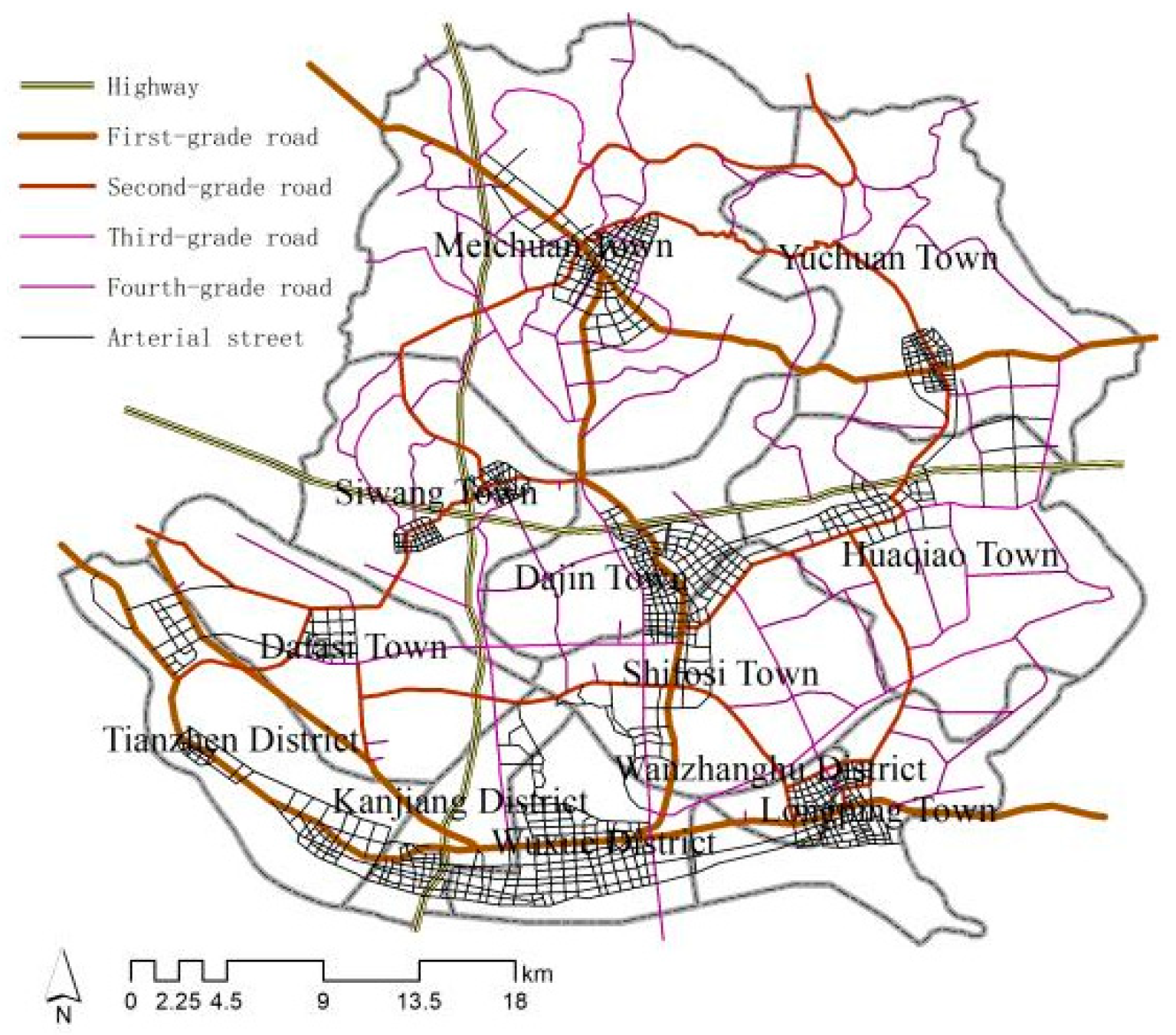
You are currently viewing a new version of our website. To view the old version click .
Applied Sciences
  • Article
  • Open Access

24 August 2022

Planning Urban Internal Transport Based on Cell Phone Data

and
School of Urban Construction, Wuhan University of Science and Technology, Wuhan 430065, China
*
Author to whom correspondence should be addressed.

Abstract

Based on cell phone data, mining residents’ travel characteristics and regional traffic connection characteristics has become an important technology for urban road traffic planning research. Based on cell phone data extracted from Wuxue City, this paper proposes an operability method for mining regional traffic contact intensity information based on cell phone data and an urban road network evaluation method. We analyze the travel characteristics of residents and the current situation of traffic connections between towns by constructing a planning road model of Wuxue city and find that the traffic connection of Wuxue city shows a spatial development pattern with Wuxue street as the intersection, one horizontal and one vertical, and the traffic accessibility gradually decreases from south to north. We analyze the spatial characteristics and problems of the planning of the road network in Wuxue and propose a modification plan. We verify the reasonableness of the modified plan by calculating traffic accessibility and road density. The research provides a new way to obtain spatio-temporal information about passenger flows by applying cell phone data to urban road planning.

1. Introduction

In the era of the popularization of mobile phones, scholars can extract a large number of data samples from cell phones during the process of using them for related planning research. Compared with traditional survey methods, mobile phone surveys have many advantages, such as low cost, wide coverage, and less processing time, and they have been conducted for multiple aspects of research in different fields by many scholars.
In the application research of urban transportation planning, the travel origin-destination (OD) survey is an important reference basis for solving traffic problems. It objectively and truly reflects the traffic flows between districts and the overall situation of residents’ travel. As an indispensable communication tool in people’s daily lives, mobile phones record for a long time, and at the same time, the penetration rate of mobile phones in life is high. The activities of urban residents can be monitored through mobile phones, and mobile phone data have great potential in the analysis of population travel behavior. Therefore, this paper processes the signaling data of mobile phones to extract the travel characteristics of users, thereby revealing the spatial structure of travel demand.
ArcGIS is a desktop application GIS platform that integrates spatial data display, editing, query retrieval, statistics, report generation, spatial analysis, and advanced mapping. It can comprehensively process geospatial-related information and solve complex analysis problems, and has strong information processing capabilities, which are widely used in transportation network analysis and spatial layout research of transportation facilities, which reflects the high credibility of ArcGIS spatial analysis technology analysis simulation. Therefore, this article used ArcGIS software based on cell phone data and policy documents related to urban transportation planning and urban transportation road networks. We obtain important transportation facilities data and other information from transportation planning documents, and we process cell phone data through ArcGIS to obtain the travel OD spatial distribution. We sort out the flow of people across districts in Wuxue city, count the amounts of exchanges, and get the intensity of traffic connections between districts. Then, we use this network data to construct a traffic network model of Wuxue City, analyze the problems of Wuxue City traffic planning, modify the planning deficiencies, verify the optimization of the modified plan by comparing the calculation models, such as accessibility and density analysis, and verify the rationality of the planning analysis method. Finally, we summarize the application and advantages of mobile phone data for intra-city traffic planning, and the direction of future research. The results of the OD study on residential mobility can provide help and references for local governments in urban transportation planning and resident travel planning. At the same time, we hope that our planning proposals can provide references and guidance for transportation planning in Wuxue City and other similar small- and medium-sized cities.

3. Materials and Methods

3.1. Overview of the Experimental Area

This research focuses on Wuxue city, which is located in Huanggang City, Hubei Province, at the intersection of Beijing-Kowloon Railway, Hurong Expressway, and Yangtze River. In the city, a large transportation pattern of railroads, highways, and waterways has been formed. The total area of the city is about 1200.35 square kilometers, with a registered population of 784,200, and a resident population of 644,220.
According to the population density distribution map, it can be seen that the population distribution within the municipality varies more obviously. The towns with a population density of more than 500 people/km2 are mainly northern and southern towns. The urban area has the highest population density of 2442.88 persons/km2, while the lowest population density is in Wanzhang Lake District and Yuchuan Town, with 351.21 persons/km2 and 363.74 persons/km2 respectively.

3.2. Data Sources and Processing

3.2.1. Regional Data

The following data are used for the study: 1. satellite images of Wuxue City, source spatial geographic data cloud platform; 2. administrative map data of Wuxue City with geographic information, source OpenStreetMap platform; 3. Wuxue City transportation planning documents, source government official website; 4. effective cell phone data for 20 days from 10 August 10 to 29 August 2020, collected from the whole area of Wuxue City, source operator cooperation.

3.2.2. Data Processing

First, we establish the road network model according to the following workflow (Figure 1). To carry out experimental research under the same spatial coordinate system, we first drag the city satellite image map into the ArcGIS software for coordinate projection processing, and then drag the road quantity data and mobile phone data obtained from OpenStreetMap into the ArcGIS software for the same processing. This step unifies the coordinate processing of the three with geographic information to obtain a coincident data image. Through the geographic registration tool in ArcGIS, we recombine the road planning map with the above images, establish a network database, and plot the urban planning road network, passenger stations, railway stations, ports, township points, and other data in layers according to the planning map. All roads at all levels according to the standard “Highway Route Design Specification (JTG D20-2017)” are given the speed attribute: highway driving speed is 90 km/h, first-grade road driving speed is 80 km/h, second-grade road driving speed is 60 km/h, third-grade and fourth-grade road driving speed is 30 km/h, urban arterial street driving speed is 40 km/h. The construction of the urban road network model with geographic information is shown in Figure 2. Road classification is done according to their respective tasks, functions, and traffic.
Figure 1. Planning road network model construction process.
Figure 2. Planning road network.
The total number of cell phone base stations collected in the whole area of Wuxue City are 1582, and the number of base stations was 1563 after filtering with the administrative area (Figure 3), mainly in the central city of Wuxue City (Figure 4). The sample size of the data is large but does not exclude the existence of minor deviations.
Figure 3. Base station distribution map.
Figure 4. Number of base stations in each administrative region.

3.3. Test Methods

Based on cell phone data, we mainly carried out research using ArcGIS software. We obtain the spatial distribution of travel OD, and then quantitatively analyze the main contact directions and contact strengths among cities and towns in the city. Then, we undertake an evaluation of the current planning scheme in four aspects, such as road network density and traffic accessibility, and make optimization suggestions. The research process is as follows (Figure 5).
Figure 5. Research process.
The first is spatial analysis of cell phone data. The cell phone data used in this study contain the geographical coordinates of the start and end points and the amount of traffic each day. We analyze people’s travel directions, which can be used to guide traffic planning [27]. Based on information on cell phone data and the principle of operability, this paper proposes the following analysis process to mine regional traffic contact intensity information. We first project the start and end points into the built study model. According to the direction from the starting point to the destination point, we take the average of the twenty-day flow as the daily OD flow. We connect the start and end points through the data management tool, and here is the output of all travel OD lines. We symbolically display the corresponding number of traffic, and the linear line corresponds to the travel volume from small to large and from small to large to obtain the spatial distribution of passenger flow. Then, we use the location selection tool, number the cell phone data base stations of different towns, count the travel volume from each town to other towns, sort out the traffic trip table with the town as the statistical unit, obtain the OD contact of the towns and streets in Wuxue City, and analyze the main directions of outbound travel in each township, as well as the characteristics of the city’s internal connections, for the part of the comprehensive analysis of the planned road network.
Then, we analyze the planning road network. Road density refers to the ratio of the total length of roads in a certain area to that of a country. We analyze the urban road network density using Equation (1), which is calculated as:
D k = L k / A k
Among them: D k represents the road density of area k (unit: km/km2); L i represents the total length of roads in area k (unit: km); A i represents the land area of the study area k (unit: km2).
We use the ArcGIS density analysis tool to create a road density analysis map, compare the spatial distribution map of OD travel volume, and evaluate whether the traffic demand is satisfied in each area of the city. To construct an O-D cost matrix model, this paper adopts the accessibility analysis method based on the minimum resistance proposed by Allen [25]. Equation (2) presents the calculation without considering the purpose of travel and analyses the accessibility of the main activity nodes of the population in the whole city.
A = 1 n 1 j = 1 j i n ( d i j ) ,   A i = 1 n i = 1 n ( A i )
where A i denotes the cell phone data point accessibility, which is the average of the minimum resistance from that point to other data points,   d i J denotes the minimum resistance between data points i and j in terms of distance and time; A is the accessibility of the entire traffic network, which is the average of the accessibility of individual cell phone data points.
Then, the traffic station accessibility distribution map is obtained by the inverse distance weighted (IDW) interpolation method; we count the shortest path distance of each cell phone data point to reach the road intersection and calculate its average value to analyze road accessibility, which is calculated by Equation (3).
L = 1 n i = 1 n l i
where l i denotes the distance from data point i to the nearest road intersection.
By connecting the spatial data, we visualize the distance analysis map of each point arriving at the intersection. This paper adopts the accessibility evaluation method based on the average travel time proposed by Geertman et al. [28] to analyze the accessibility of passenger stations, railroads, and bus services, which is calculated by the following Equation (4):
t i = 1 n 1 j i t i j
where t i denotes the average travel time from facility point i to departure point; t i j denotes the shortest travel time from facility point i to departure point j.
We calculate the minimum time required for intermodal water–land transport interchange by the shortest path calculation method and evaluate the interchange capacity of different transportation modes in the city. The synthesis of the obtained analysis results is combined with the travel OD, which points out the shortcomings of the planning scheme and suggests optimization.
Finally, the optimized road network model is constructed, and road accessibility and road density are calculated and analyzed again to obtain the range of change after the modification to verify the effectiveness of the modification.

4. Results

4.1. Analysis of the City’s Internal Transportation Links

Taking towns as units, we count the average daily travel volume of each town and the average daily travel volume across districts. Quantitative analysis was performed to obtain statistics of trips between towns (Table 2), and the map (Figure 6) of spatial linkage intensity between different regions to better determine the characteristics of regional passenger flow and provide a basis for the adjustment and construction of traffic road networks [29]. The total number of passenger trips within the city limits of Wuxue City totals 635,900• d 1 . Inter-regional travel occurs mainly in the Wuxue District and Meichuan Township.
Table 2. Statistics of trips between towns.
Figure 6. Spatial linkage intensity between different regions. (a) Administrative district level. (b) Township district level.
The table fills the larger travel volume with color. The yellow markers show that the main urban area, Wuxue District, is strongly connected to Shifosi Town, Huaqiao Town, Meichuan Town, Longping Town, and Tian Town District, with the connection axis being Meichuan-Dajin-Shifosi-Wuxue, running north-south, mainly along the Mayang Expressway, and Tian Town-Wuxue-Longping at the southern end of Wuxue City, running east-west along the Yangtze River, the overall traffic connection strength shows a spatial development pattern with Wuxue Street as the intersection and a horizontal and vertical direction (Figure 7a). The green markers show that a stronger town connection is mainly between Meichuan Town, Yuchuan Town, Huaqiao Town, Shifosi Town, and Dajin Town (Figure 7b), and the traffic demand space is circular, which can increase the circular traffic facilities in order to evacuate the urban traffic gathering.
Figure 7. Spatial connection analysis. (a) City and town links. (b) Town and town links.
We count the internal travel OD passenger flow of each town (Figure 8). Meichuan town has the highest intra-town travel volume, followed by Huaqiao town and Shifosi town. For the areas with high intra-regional travel rates, considering their internal traffic demand degree is large, we can increase the public transportation operation, analyze the important traffic nodes according to the travel OD, and reasonably design the bus routes to solve intra-town traffic travel.
Figure 8. Internal travel OD statistics for each town.

4.2. Planning Road Network Density Analysis

The road network density analysis shows that the road density of each administrative district is quite different (Figure 9a), that the spatial distribution of the road network is unbalanced, and that spatial distribution has a certain concentration, mainly concentrated in the southern part of the city center area, and Meichuan town, Dajin town, and Shifosi town.
Figure 9. Analysis of road network density and travel OD passenger volume distribution. (a) Road network density (b) Administrative district level. (c) Township district level.
Comparing the planning road network density analysis with the travel OD passenger volume distribution (Figure 9a), we find that the road network density and travel OD passenger flow are imbalanced in the circled regional (Figure 9b,c). First, we need to strengthen the southeast of the towns of Wuxue City and improve the skeleton road network in the city for the town of Huaqiao, the southern part of the town of Shifosi, and other areas where the regional road network density is low. We need to strengthen road construction.

4.3. Traffic Accessibility Analysis

The accessibility of the urban traffic road network reflects the service scope of urban road networks and the convenience of urban residents’ travel, the degree of interaction between regions within the city, and to a certain extent, it can analyze the defects of urban road networks [30], so this paper studies the accessibility of traffic road networks in Wuxue City based on travel time and travel distance [31].
We obtain the accessibility distribution of the main crowd activity nodes in the city based on the analysis of cell phone data by constructing the OD matrix model (Figure 10). The crowd is mainly concentrated in the south of Wuxue City, and the accessibility of the main distribution points of crowd activity gradually decreases from south to north, and the accessibility is better in the areas with greater travel demand, but the traffic demand of Meichuan Town and Huaqiao Town, which are located in the east and north of Wuxue City is also greater from the above linkage analysis, their accessibility is poor, and the road network needs further improvement. The accessibility of the central part of the city, where highways and provincial roads are located, is high, while the eastern part of the town of Yuchuan and Huaqiao has fewer roads and poorer accessibility. The planning of the road network in the eastern and northern areas of Wuxue City needs to be further improved.
Figure 10. Accessibility analysis based on travel time.
Traffic intersections are generated by the intersection of more than two roads, which can lead to multiple directions. The average distance value of cell phone data points arriving at the nearest intersection is calculated to be 535.77 m; the standard deviation is 655.04 m. Furthermore, 67.64% of the distance is less than 500 m. The natural interruption point classification is used to obtain the road accessibility analysis map (Figure 11).
Figure 11. Accessibility analysis based on travel distance.

4.4. Accessibility Analysis of Important Transportation Facilities

Various transportation facilities in the city affect the flow of people. For small and medium-sized cities, the most important transportation facilities are passenger transport stations, railway stations, etc., and we analyze the time required for the arrival of important transportation facilities in the city through the GIS platform and evaluate its accessibility with a travel time of 5 min as a unit [32,33,34]. In constructing a service area analysis model and obtaining the accessibility distribution map of the planned passenger transport stations (Figure 12), the color in the map from red to blue shows that the time required for the arrival of important transportation facilities gradually increases. The reachable area within 5 min of passenger stations reaches 385.72 km2 by calculated at the vehicle speed attribute set by each level of road, accounting for 32.1% of the city area.
Figure 12. Accessibility analysis of passenger stations.
The passenger railroad station is located in the middle of Wuxue city, and its analysis map (Figure 13) clearly shows that the accessibility of the railroad station extends outwards in a cross shape along the city highway and primary highway, and the accessibility gradually decreases, but people in the city can basically reach Wuxue station within 25 min.
Figure 13. Accessibility analysis of railroad.
The activity distribution and bus stop distribution map of the central urban area shows that the crowd activities are relatively concentrated in the south of the urban center (Figure 14a), and the bus stops are also relatively concentrated in the south. According to the 15-min and 10-min living circles defined in the 18th edition of the Urban Residential Planning and Design Standards, the accessibility of public transportation in the urban area of Wuxue was studied by analyzing the service areas of 300 m and 500 m, with the bus stop as the center. The accessibility of downtown bus stops from the center to the outside gradually decreases, but the overall accessibility of bus services is great (Figure 14b).
Figure 14. Analysis of bus station distribution. (a) Distribution of activity in the central urban area of Wuxue city. (b) Distribution of bus stops and service area.

4.5. Analysis of the Water-Land Transport Network Structure

The convenience of transfer between water and land transportation affects the passenger and freight volume of water transport, and guides the coordinated development of water-land transport to reduce the “strong land and weak water” and provide multi-modal travel for residents, which contributes to the improvement of comprehensive urban transport services and socio-economic development [34].
Wuxue City is located on the north of the Yangtze River, has good port resources, and planning also proposed the construction of Wuxue Port to further promote the development of Wuxue from a single port to the overall development of the port group to improve the city’s railroad, highway, and water transport network system. The main transport channels for Tianzhen port are the G347 national highway, the S308 provincial highway, the S411 provincial highway, and the Tianzhen railroad line. The main transport channels for Wuxue port are the G347 national highway, the Mayang highway, and the G220 national highway (Figure 15a). The number of railway stations and ports was kept separate from this for a subsequent calculation (Figure 15b).
Figure 15. Water-land transport network. (a) Railways and port planning. (b) Railway stations and port serial numbers.
Based on the accessibility evaluation of minimum impedance, we analyzed the water and land transportation network in Wuxue City. We calculated the time required for ports to reach railroad freight stations and railroad passenger stations, respectively, and then analyzed the interchangeability of the planned road network. We use the road speeds of each class to calculate the average time. The average time for each port to arrive at the freight station is 16 min and the longest time is 24 min, as shown in Table 3, and the average time taken to arrive at the Wuxue station is 18 min and the longest time is 24 min. The interchange time has improved compared with the current situation, as shown in Table 4.
Table 3. Planning port-railway freight station transfer time statistics.
Table 4. Planning port-railway passenger station transfer time statistics.
Both the Tianzhen port area and the Wuxue port area are close to Wuxue city, water transport passenger flow is mainly concentrated in Wuxue port area. In the city’s central area, bus service coverage is mainly concentrated in the blue area. For the red area, the connection among various means of transportation is poor, resulting in inconvenient travel for residents, as shown in Figure 16. Set along the river bus lines, through water transport, traffic can quickly contact the surrounding cities.
Figure 16. Ports and city bus stop coverage distribution map.

5. Discussion

5.1. Modify the Planning Road Network

Based on the comprehensive analysis set out above, we propose the following optimization strategies.
  • Strengthen effective connectivity between towns.
There are few connecting roads between towns, and there is traffic congestion. We suggest that additional road networks are needed to strengthen inter-regional links. The specific modification is shown in the figure below (Figure 17 and Table 5).
Figure 17. Add new roads.
Table 5. Modification description.
2.
Enhancing accessibility to the eastern and northern parts of the city.
The ecological zones are concentrated in the eastern and northern regions of Wuxue City, which are not conducive to the construction of new roads, but one can upgrade the existing roads, which would shorten travel time and enhance traffic accessibility. One could add town railway lines in the northeastern part of the city to strengthen the connection between the Yuchuan Township and the surrounding towns, as well as the connection between the town groups in the eastern and northern areas of Wuxue City. The red line indicates the upgrade of the original third-grade road to the second-grade road, as shown in the following design (Figure 18).
Figure 18. Modify the road grade.
3.
Improve town bus service lines.
There are some towns with a large amount of internal travel OD, such as Meichuan town and Huaqiao town. These towns can increase bus services; according to travel OD passenger flow spatial distribution, we suggest increasing bus service lines reasonably. In addition, Meichuan and Huaqiao town have larger contact with the Wuxue district, and the bus service system can be intermodal with urban environment-specific bus stops and line design, as follows (Figure 19 and Figure 20).
Figure 19. Travel OD distribution and bus route design in Meichuan Town.
Figure 20. Travel OD distribution and bus route design in Huaqiao town and Yuchuan town.

5.2. Comparative Analysis before and after the Modification of the Planning Scheme

The modified road network model is constructed to analyze road network accessibility and road density.
  • Accessibility enhancement.
Based on the minimum resistance accessibility, we obtain the accessibility of the road network after the planning modification (Figure 21). We calculate the area of different reachable time ranges to compare before and after modification, and calculate the difference between before and after, and then the difference is divided by the value before modification to get the ratio of the improvement value (Table 6). In areas where passenger flow is relatively concentrated, the arrival time has been shortened.
Figure 21. Accessibility analysis based on travel time after modification.
Table 6. Comparison of accessibility indicators before and after modification.
The average distance value of cell phone data points arriving at the nearest intersection was calculated to be 429.24 m, and the standard deviation is 675.19 m. Additionally, 74.12% of the distance is less than 500 m. The road accessibility analysis map was obtained using a natural interruption point classification (Figure 22).
Figure 22. Accessibility analysis based on travel distance after modification.
2.
Improvement of road network density.
According to cell phone data and travel OD spatial analysis, with the suggested modifications, we reasonably increase the road in the data distribution concentration area and large travel passenger flow area. The road density analysis (Figure 23) below shows that the color of these areas has deepened, and the increase in road density enhances the decongestion capacity of the area to reduce traffic congestion.
Figure 23. Analysis of road network density after modification.
After the modification of increasing the high-grade road linking between towns and improving the internal road network, the total mileage of main roads is 1542.286 km, and the density of the main road network in Wuxue City is calculated to be 1.284 km/ km 2 , which is 109.177 km higher than the total mileage before modification, and the density of the main road network is increased by 7.3% (see in Table 7), mainly improving the road network in Meichuan Town, Huaqiao Town and Shifosi Town, the color in the passenger flow concentration area has deepened (see in Figure 24).
Table 7. Comparison of the density before and after modification.
Figure 24. Comparison analysis of road network density before and after modification.

6. Conclusions

The advantage of using cell phone data for road traffic planning is that mobile phone data record the trajectory of residents’ travel, which is equivalent to the passenger traffic flow between cities and towns, and this can be used to measure the degree of connection between cities and towns. This article proposes a technical framework for cell phone data to support traffic planning. The travel OD obtained from cell phone data is combined with ArcGIS analysis to analyze the main outflow direction of the city, the intensity of traffic connections between cities and towns, and the service range of important urban transportation facilities. This research provides an operable technical means for road planning and makes up for the lack of traditional data. Based on regional connection analysis, we evaluate whether the spatial distribution of planned road network density, road accessibility, and passenger bus station allocation are consistent with actual needs and use the above analysis as a guide to modify the planning road network. The rationality and effectiveness of the revised plan are verified through calculation and analysis at the end of the article. The application of cell phone data to traffic planning can objectively reflect the spatial characteristics of traffic travel and provide quantitative support for urban traffic planning.
This article proposes a technical framework for urban internal traffic applications based on cell phone data, but it still has limitations. Its analysis uses the speed of the vehicles on different grades of roads to refer to the road design specification, which leads to a lack of authenticity, and the time calculation lacks accuracy. In future work, we will further explore the application value of mobile phone data, explore how to allocate travel OD lines to the road network based on the shortest path, obtain road traffic flow, better quantitatively analyze the road network, and research methods for obtaining other information data that can be used for transportation planning.

Author Contributions

Conceptualization, H.X.; methodology, H.X. and J.Z.; software, J.Z.; validation, J.Z.; formal analysis, J.Z.; investigation, H.X. and J.Z.; resources, H.X.; data curation, H.X.; writing—original draft preparation, J.Z.; writing—review and editing, J.Z.; visualization, J.Z.; supervision, H.X.; project administration, H.X.; funding acquisition, H.X. All authors have read and agreed to the published version of the manuscript.

Funding

The research was funded by the key projects of philosophy and social sciences of Hubei Provincial Department of Education (Grants#20D025), the National Natural Science Foundation of China (Grants#41771473), and the Hubei Construction Science and Technology project (Grants#20170904).

Institutional Review Board Statement

Not applicable.

Data Availability Statement

“Satellite images of Wuxue City” at http://www.gscloud.cn/sources/, (accessed on 13 April 2021) “administrative map data of Wuxue City” at https://www.openstreetmap.org/export#map=11/30.0325/115.7135 (accessed on 11 August 2021), “Wuxue City transportation planning documents“ at http://www.wuxue.gov.cn/ (accessed from 1 January 2020 to 26 August 2021), “cell phone data” at operator cooperation.

Conflicts of Interest

The authors declare no conflict of interest.

References

  1. Fan, Y. Bayesian statistical method for estimating OD trip matrix from road traffic volume. J. Tongji Univ. 1991, 2, 227–233. [Google Scholar]
  2. Li, J.; Peng, G. Research on the Method of Estimating OD Trip Volume from Road Section Traffic Volume—Iterative Inverse Method Based on Multi-path Probability Allocation Model. J. Traffic Transp. Eng. 2001, 2, 78–82. [Google Scholar]
  3. Shi, F. Research on the Construction Method of Bus OD Matrix Based on IC Card Data. Master’s Thesis, Jilin University, Changchun, China, 2004. [Google Scholar]
  4. Li, Y.; Yuan, Z.; Xie, H.; Cao, S.; Wu, X. Analysis of taxi travel characteristics based on taxi OD data. Transp. Syst. Eng. Inf. 2016, 5, 85–89. [Google Scholar]
  5. Wu, Z.; Zhu, L.; Li, C. Parking demand prediction method and application. Urban Transp. 2008, 4, 77–81. [Google Scholar]
  6. Lu, F.; Chen, X.; Hu, X. Research on Residents’ Public Transport Trip Characteristics Based on Public Transport OD Data. J. Transp. Eng. Inf. 2010, 8, 31–36. [Google Scholar]
  7. Liu, X. Research on Public Transportation Optimization of Urban Peripheral Communities Based on Rail Transit Connection. Master’s Thesis, Xi’an University of Architecture and Technology, Xi’an, China, 2014. [Google Scholar]
  8. Gao, W. Research on Passenger Flow Forecasting Method at the Initial Stage of Urban Rail Transit Line Operation. Master’s Thesis, Shijiazhuang Railway University, Shijiazhuang, China, 2014. [Google Scholar]
  9. Wang, S. Analysis on the Characteristics of Inter-City Passenger Travel Behavior in Urban Agglomerations. Master’s Thesis, Chang’an University, Xi’an, China, 2015. [Google Scholar]
  10. Ma, Z. Mobile Phone-Based Traffic Information Collection and Processing Technology. Master’s Thesis, Chongqing Jiaotong University, Chongqing, China, 2009. [Google Scholar]
  11. Huang, M.; Lu, B. Traffic OD data acquisition technology based on mobile phone positioning. J. Chongqing Jiaotong Univ. 2010, 29, 162–166. [Google Scholar]
  12. Wu, Y. Dynamic OD Acquisition Method Based on Mobile Phone Location Information and Travel Survey. Master’s Thesis, Beijing Jiaotong University, Beijing, China, 2014. [Google Scholar]
  13. Tang, J. Research on the Acquisition Method of Residents’ Travel OD Matrix Based on Mobile Phone Location Data. Master’s Thesis, Southwest Jiaotong University, Chengdu, China, 2016. [Google Scholar]
  14. Widhalm, P.; Yang, Y.; Ulm, M.; Athavale, S.; González, M.C. Discovering urban activity patterns in cell phone data. Transportation 2015, 42, 597–623. [Google Scholar] [CrossRef] [Green Version]
  15. Yin, L.; Lin, N.; Zhao, Z. Mining Daily Activity Chains from Large-Scale Mobile Phone Location Data. Cities 2020, 109, 103013. [Google Scholar] [CrossRef]
  16. Yang, X.; Fang, Z.; Yin, L.; Li, J.; Zhou, Y.; Lu, S. Understanding the Spatial Structure of Urban Commuting Using Mobile Phone Location Data: A Case Study of Shenzhen, China. Sustainability 2020, 10, 1435. [Google Scholar] [CrossRef] [Green Version]
  17. Zhou, X.; Yeh, A.G.O.; Yue, Y. Spatial variation of self-containment and jobs-housing balance in Shenzhen using cell phone data. J. Transp. Geogr. 2018, 68, 102–108. [Google Scholar] [CrossRef]
  18. Hu, Z.; Qiu, W.; Piao, L.; Chen, M. The application of mobile phone big data in urban comprehensive transportation planning: Taking Zhanjiang City Comprehensive Transportation Planning Resident Trip Survey as an Example. Big Data Urban-Rural Gov. Semin. Proc. 2015, 7. [Google Scholar]
  19. Shan, B.; Luo, X.; Pang, L. The application and thinking of traffic planning based on mobile phone signaling data-taking Harbin as an example. In Proceedings of the China Urban Transportation Planning Annual Conference, Chengdu, China, 16 October 2019; Volume 21. [Google Scholar]
  20. Sha, J.; Chen, G. Application analysis of mobile phone big data in urban transportation planning. Traffic Transp. 2017, 1, 104–107. [Google Scholar]
  21. Imai, R.; Ikeda, D.; Shingai, H.; Nagata, T.; Shigetaka, K. Origin-Destination Trips Generated from Operational Data of a Mobile Network for Urban Transportation Planning. J. Urban Plan. Dev. 2021, 147, 04020049. [Google Scholar] [CrossRef]
  22. Fan, Z.; Pei, T.; Ma, T.; Du, Y.; Song, C.; Liu, Z.; Zhou, C. Estimation of urban crowd flux based on mobile phone location data: A case study of Beijing, China. Comput. Environ. Urban Syst. 2018, 69, 114–123. [Google Scholar] [CrossRef]
  23. Han, T. Research on Bus Route Planning Method Based on Mobile Phone Location Data. Master’s Thesis, Chengdu University of Information Technology, Chengdu, China, 2019. [Google Scholar]
  24. Wang, Z.; Wang, S.; Lian, H. A route-planning method for long-distance commuter express bus service based on OD estimation from mobile phone location data: The case of the Changping Corridor in Beijing. Public Transp. 2020, 13, 101–125. [Google Scholar] [CrossRef]
  25. Jia, M. Research on the Optimization of Small and Medium-Sized City Bus Network Based on Mobile Phone Signaling Positioning Data. Master’s Thesis, Chang’an University, Xi’an, China, 2019. [Google Scholar]
  26. Wang, M.; Stewen, S.; Broek, N.V.; Thomas, M. Estimating Dynamic Origin-Destination Data and Travel Demand Using Cell Phone Network Data. Int. J. Intell. Transp. Syst. Res. 2013, 11. [Google Scholar] [CrossRef]
  27. Chen, H.; Cai, M.; Xiong, C. Research on Human Travel Correlation for Urban Transport Planning Based on Multisource Data. Sensors 2020, 21, 195. [Google Scholar] [CrossRef] [PubMed]
  28. Luisa, G.A.; Jorge, N.; Adolfo, R.M. Assessing Urban Accessibility in Monterrey, Mexico: A Transferable Approach to Evaluate Access to Main Destinations at the Metropolitan and Local Levels. Appl. Sci. 2021, 11, 7519. [Google Scholar]
  29. Lu, S.; Fang, Z.; Zhang, X.; Shaw, S.-L.; Yin, L.; Zhao, Z.; Yang, X. Understanding the Representativeness of Mobile Phone Location Data in Characterizing Human Mobility Indicators. ISPRS Int. J. Geo-Inf. 2017, 6, 7. [Google Scholar] [CrossRef] [Green Version]
  30. Gao, G.; Wang, Z.; Liu, X.; Li, T. An Empirical Spatial Accessibility Analysis of Qingdao City Based on Multisource Data. J. Adv. Transp. 2020, 2020, 7570148. [Google Scholar] [CrossRef]
  31. Jiang, Y.; Guo, D.; Li, Z.; Hodgson, M.E. A novel big data approach to measure and visualize urban accessibility. Comput. Urban Sci. 2021, 1, 10. [Google Scholar] [CrossRef]
  32. Hosseini, A.; Farhadi, E.; Hussaini, F.; Pourahmad, A.; Akbari, N.S. Analysis of spatial (in)equality of urban facilities in Tehran: An integration of spatial accessibility. Environ. Dev. Sustain. 2021, 24, 6527–6555. [Google Scholar] [CrossRef]
  33. Graells-Garrido, E.; Serra-Burriel, F.; Rowe, F.; Cucchietti, F.M.; Reyes, P. A city of cities: Measuring how 15-minutes urban accessibility shapes human mobility in Barcelona. PLoS ONE 2021, 16, e0250080. [Google Scholar] [CrossRef]
  34. Liu, X. Design of Water-land intermodal transportation of urban passenger ferry based on full trip chain. China Shipping. China Water Transp. 2020, 2, 101–104. [Google Scholar]
Publisher’s Note: MDPI stays neutral with regard to jurisdictional claims in published maps and institutional affiliations.

Article Metrics

Citations

Article Access Statistics

Multiple requests from the same IP address are counted as one view.