Abstract
Ion-adsorption type rare earth element (IREE) deposits are critical strategic resources formed under strong lithological, geomorphological, and weathering controls. In Houaphanh Province, Laos, widespread granitic intrusions and tropical monsoon weathering provide favorable conditions for IREE mineralization; however, exploration is limited by rugged terrain, dense vegetation cover, and sparse geological data. This study integrates Landsat 9, ASTER multispectral, and digital elevation data to enhance IREE exploration. Band ratio and principal component analysis (PCA) were applied to extract lithological and alteration features, while six topographic parameters describing elevation, slope, relief amplitude, incision depth, surface roughness, and elevation variability were derived from ASTER GDEM data. These datasets were combined using a weighted overlay to delineate favorable geomorphic zones. Six prospectives zones were identified, and field verification at Nongkhang confirmed 19 IREE ore bodies. The results demonstrate that integrating spectral and topographic indicators significantly improves the accuracy for IREE prediction in tropical, densely vegetated regions, offering a transferable framework for similar geological settings worldwide.
1. Introduction
Rare earth elements (REEs) are critical strategic materials for modern technologies and the development of green energy [1,2]. Among global REE resources, ion-adsorption type deposits (IREE) formed through the prolonged weathering of rocks are particularly important because of their low environmental impact and high economic value. These deposits typically form through prolonged tropical weathering, which concentrates REEs in clay-rich regolith [3,4]. Laos hosts widespread Indosinian-age (255–200 Ma) granitic intrusions that have been extensively weathered under tropical monsoon conditions, producing the clay-rich regolith favorable for IREE development [5].
Despite these favorable conditions, systematic IREE exploration in Laos remains limited due to rugged terrain, and sparse geological data. The region is predominantly forested, with tropical evergreen and deciduous forests interspersed with bamboo and secondary regrowth, which further complicates traditional field-based surveys. Remote sensing offers an effective means to overcome these challenges by enabling large-scale, lithological, and alteration mapping [6].
To address these limitations, this study integrates multispectral remote sensing with digital elevation model (DEM)-derived topographic analysis to delineate IREE prospectivity zones. ASTER and Landsat 9 imagery were used to extract lithological and alteration features through band ratio and principal component analysis (PCA), while six topographic factors were derived from ASTER GDEM data, quantifying geomorphic influences on mineralization. A weighted overlay analysis was applied to integrate these datasets, and field validation in the Nongkhang area [7] confirmed 19 IREE ore bodies within a 3.547 km2 mineralized zone, demonstrating the reliability of this integrated approach for IREE exploration in tropical terrains.
2. Regional Geological Setting
2.1. Geological Background
Houaphanh in northern Laos lies within the southern segment of the Ma Jiang suture zone, occupying a transitional position between the eastern Tethyan and western Pacific domains, and records a complex Paleotethyan to Mesozoic evolution involving subduction-related magmatism and Indosinian–Mesozoic intraplate reorganization (Figure 1a) [8].
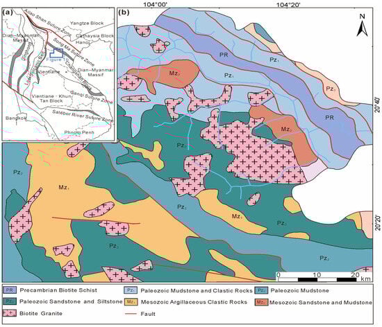
Figure 1.
Geological setting of the study area. (a) Simplified tectonic map of Laos and adjacent regions; the blue polygon delineates the study area. (b) Lithological distribution of the Houaphanh region. PR, Pz, and Mz denote the Precambrian, Paleozoic, and Mesozoic eras, respectively (modified after [8]).
During the Tethyan stage, repeated subduction and crustal melting generated widespread I-type and S-type granitic intrusions. Subsequent Indosinian compressional tectonism in the Mesozoic triggered extensive magmatism, producing large intermediate- to acidic-composition plutons that now dominate the bedrock of Houaphanh Province and serve as parent rocks for IREE mineralization [8,9].
Since the Cenozoic, the region has remained tectonically stable under a humid tropical monsoon climate influenced by the Indian Ocean. High rainfall (112.81 mm annually) and temperature promote intense chemical weathering, creating favorable conditions for the formation of ion-adsorption (lateritic) type REE deposits [3,8].
2.2. Genesis and Occurrence Conditions of Ion-Adsorption Type REE Deposits
REE deposits are broadly classified as endogenic or exogenic according to their formation processes. Endogenic types, including carbonatite-related, alkaline igneous, and hydrothermal-vein deposits, originate from magmatic or hydrothermal activity and host REEs in discrete minerals such as monazite, xenotime, and bastnäsite. Exogenic types form through surface weathering, sedimentation, or secondary enrichment and include placer, weathering-crust, and ion-adsorption deposits [9,10].
Intense weathering releases REEs from primary minerals, after which they become weakly bound to clay minerals such as kaolinite and illite, forming regolith-hosted deposits where REEs occur in adsorbed form rather than as discrete minerals [3,11]. IREE deposits represent a distinctive exogenic subtype formed by the prolonged chemical weathering of REE-enriched granitic rocks [12]. Residual primary REE phases (e.g., monazite, xenotime) may persist locally, but they generally constitute a minor component.
The development and preservation of IREEs are strongly influenced by climatic and geomorphic conditions. Warm, humid tropical to subtropical climates promote deep weathering, while moderate slopes and gentle relief favor regolith stability. Excessive erosion removes weathered material and limits enrichment, whereas stable terrain allows the long-term accumulation of REE-bearing clays [3,11].
2.3. Metallogenic-Potential of Ion-Adsorption Type REEs in Houaphanh, Laos
Houaphanh hosts extensive Permian–Triassic biotite monzogranites enriched in rare earth elements (Figure 1b) [4]. These granitic rocks are composed mainly of feldspar which readily weathers to form clay minerals, and quartz, which remains largely as a residual phase. Their high silica and alumina contents provide favorable parent material for REE adsorption onto clay minerals [9,11].
Topography exerts a major control on the development and preservation of REE-bearing regoliths. Situated along the western margin of the Annamite Range, Houaphanh is characterized by rugged mountains trending NW-SE, with elevations ranging from below 300 m in valleys to over 2000 m at peaks. Much of the terrain lies above 1000 m, where dense forest covers and intense weathering favor regolith development and retention. The Ma River system, which drains the region, shapes erosion patterns and regolith stability. Areas with moderate slopes, shallow incision, and gentle relief provide optimal conditions for the preservation of REE-enriched weathering crusts [13].
Taken together, the presence of REE-enriched granitic parent rocks, a humid tropical climate, and favorable geomorphic conditions provide an excellent geological–geochemical setting for IREE formation, making Houaphanh Province one of the most promising target areas for REE exploration in Laos.
3. Methods
This study integrates multispectral remote sensing data with digital elevation model (DEM)-derived topographic factors to identify favorable zones for IREE mineralization in Houaphanh Province, Laos. The methodological workflow involves three main components: (1) remote sensing-based lithological and alteration extraction, (2) topographic factor derivation, and (3) multi-source data integration for metallogenic prediction.
All parameters were standardized and reclassified in ArcGIS 10.8 to a uniform scale to facilitate subsequent spatial integration and analysis. Lithological, alteration, and topographic datasets were integrated using a weighted overlay approach within the ArcGIS platform to generate a metallogenic favorability map. Since no well-documented IREE occurrences exist within the study area to serve as calibration references for terrain-based weighting, this study applied equal weighting coefficients to the topographic parameters within their respective favorable ranges. This approach ensures a balanced representation of geomorphic influences on regolith preservation, although it does not account for variations in factor significance. The resulting map highlights zones where favorable lithology, strong alteration anomalies, and stable geomorphic conditions coincide, indicating high potential for IREE mineralization.
Field validation involved systematic geological field surveys, core drilling, and sampling (Figure 2). The surveys focused on mapping lithology, structures, and weathering profiles to identify favorable zones for ion-absorbed rare earth mineralization. Representative samples were collected from drill for chemical analysis (Figure 2c) [7].
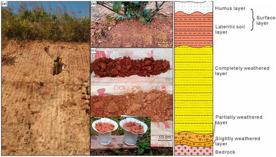
Figure 2.
Field validation and schematic representation of the weathering-crust profile in the Bannanao deposit area, Nongkhang District, Xam Neua City, Houaphanh Province. (a) Outcrop profile at the drilling site; (b) surface soil horizon at the same site; (c) drill-core samples from the completely weathered layer. Samples were collected from borehole BSNZK003, where preliminary results indicate a moderate degree of mineralization. No bedrock exposure was observed at the base of the profile. The diagram on the right presents a schematic illustration of an ion-adsorption-type rare-earth weathering crust (modified after [7]).
The overall methodological workflow is illustrated in Figure 3.
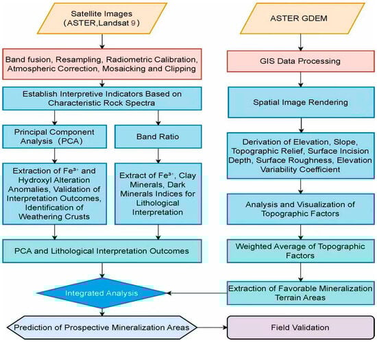
Figure 3.
Workflow of the integrated analysis combining multispectral imagery with DEM-derived topographic parameters.
3.1. Remote Sensing Data and Preprocessing
The primary datasets include ASTER multispectral imagery and ASTER GDEM elevation data which were obtained from NASA’s Earth data platform (https://search.earth.nasa.gov). ASTER provides 14 spectral bands covering the visible–near-infrared (VNIR), shortwave infrared (SWIR), and thermal infrared (TIR) ranges 15, 30, and 90 m, respectively (Table 1) [14,15]. For analysis, all imagery was resampled to a uniform spatial resolution of 30 m to ensure consistency with the ASTER GDEM data. This resolution was sufficient to meet the mineral prospectivity prediction objectives of this study. Landsat 9 imagery was obtained from USGS Earth Explorer to complement ASTER data for regional lithological mapping. Following the approach of [16], diagnostic spectral band ratios were selected to enhance mineral-specific absorption and reflection features.

Table 1.
Spectral band parameters and wavelength ranges of the ASTER sensor.
All satellite imagery was preprocessed to ensure optimal data quality. Geometric correction, radiometric calibration, and atmospheric correction were performed using ENVI 5.6. To minimize interference from vegetation, water bodies, and clouds, masking was applied using spectral indices: the normalized difference vegetation index (NDVI = (NIR − R)/(NIR + R)) for vegetation removal and the normalized difference water index (NDWI = (B2 − B6)/(B2 + B6)) (Figure 4) for identifying water and cloud-covered areas. These preprocessing steps ensured that only bare land and weathering crusts were retained for subsequent analysis. The ASTER GDEM dataset, with a spatial resolution of 30 m, was then employed to derive geomorphological parameters, selected for its proven reliability in rugged tropical terrain [17].
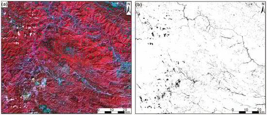
Figure 4.
(a) ASTER RGB 3-2-1 false-color composite image (Red or dark red indicates vegetation, while white to light blue primarily represents exposed surfaces. White or light gray indicates bare rocks or sediments, and deep blue or black represents water bodies or shaded areas.). (b) Vegetation, water, and cloud masking results based on spectral indices (black areas represent masked vegetation, clouds, and water bodies).
3.2. Data Analysis Methods
3.2.1. Band Ratio Method
Rock-forming minerals display characteristic absorption and reflection features across specific wavelength ranges, allowing remote sensing to differentiate lithological units [15]. To enhance spectral contrast and emphasize diagnostic mineral features, several band ratios were calculated based on the absorption and reflection properties of specific minerals within the ASTER spectral range.
Within the visible to near-infrared (VNIR) range, the Fe3+ index (b2/b1) (Figure 5a) was calculated to enhance ferric iron absorption between 0.55 and 0.65 µm, and the Fe2+ index (b1/b2 + b5/b3) was applied to detect ferrous iron-bearing silicates that exhibit absorption features between 0.6 and 1.2 µm [18,19].
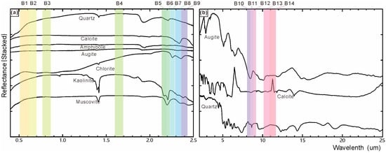
Figure 5.
(a,b) Typical spectral reflectance curves of rock-forming minerals in the visible–near-infrared (VNIR)(B1–B3), shortwave infrared (SWIR) (B4–B9), and thermal infrared (TIR) (B10–B14) ranges. Labels B1–B14 correspond to ASTER bands 1–14.
In the shortwave infrared (SWIR) range, the clay mineral index ((b5 + b7)/b6) was computed to capture Al–OH absorption near 2.2 µm associated with clay minerals such as kaolinite and muscovite, while the dark mineral index ((b6 + b9)/b8) was designed to detect Mg–OH absorption around 2.34 µm, typical of biotite-, amphibole-, and chlorite-bearing rocks [18,19].
In the thermal infrared (TIR) range, spanning 8–14 µm, four indices were applied to identify major rock-forming minerals. The silicate index (b11/b14) was used to detect Si–O stretching vibrations between 8.3 and 11.3 µm, the mafic index (b12/b13) to estimate mafic mineral abundance inversely correlated with SiO2 content. The quartz index (b11/(b10 + b12) × (b13/b12)) was calculated to map quartz-bearing lithologies such as granites and quartz sandstones [20], and the calcite index (b14/b13) to identify carbonate rocks with absorption near 11.2 µm [13,18].
Six of the seven calculated indices were used to construct band index maps (Figure 6), which were then merged using a false-color composite (FCC) technique [13,18] to improve lithological discrimination and highlight alteration zones associated with weathering crust development and potential REE enrichment.
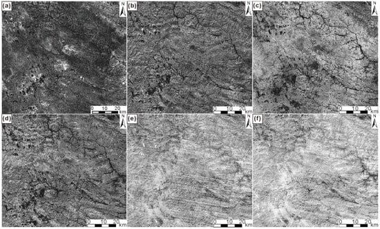
Figure 6.
Band ratio index maps of the Houaphanh region. (a) Fe3+ Index, (b) Dark Mineral Index, (c) Silicate Mineral Index, (d) Clay Mineral Index, (e) Quartz Index, (f) Calcite Index.
The Landsat 9 band ratio b4/b2 was used as an iron oxide index, enhancing ferric-iron absorption in the visible range, where Band 2 (blue) records absorption and Band 4 (red) (Table 2) [21] highlights strong iron-related reflectance (Figure 7b). The b6/b7 ratio served as a clay and hydroxyl index, emphasizing Al–OH absorption features near 2.2 µm, typical of kaolinite and muscovite (Figure 7c). In contrast, the b6/b5 ratio identified ferrous and dark-mineral-bearing lithologies, such as biotite- and amphibole-rich rocks.
Table 2.
Key OLI-2 spectral requirements and band average performance. Both instruments met requirements and their spectral similarity enhances continuity between the two instruments.
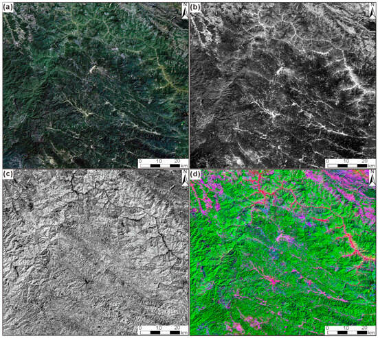
Figure 7.
Landsat 9 images (a) True-color composite image of the Huaphan region in Laos, RGB: 4-3-2; (b) Single-band image of the iron oxide index (b4/b2); (c) Hydroxyl alteration anomaly (b6/b7); (d) RGB color composite with where red represents a band ratio of 4/2, green represents a band ratio of 6/7, and blue represents a band ratio of 6/5. The more vibrant a color appears in a particular region, the higher the corresponding index or the concentration of a specific ratio within that region is likely to be.
A false-color composite (RGB = b4/b2, b6/b7, b6/b5) (Figure 7d) was then generated to integrate these indices, effectively enhancing the spectral contrast of oxidation, hydroxyl, and ferrous alteration zones associated with weathering and potential REE enrichment [16].
3.2.2. Principal Component Analysis (PCA)
Principal component analysis (PCA) was applied to selected ASTER bands to isolate spectral signatures of alteration minerals associated with weathering and potential REE enrichment. Diagnostic spectral bands corresponding to key alteration minerals were selected based on their characteristic absorption and reflection features, and multispectral data were subjected to orthogonal transformation to separate correlated spectral information [22,23].
For iron-oxide alteration, Bands 1–4 were analyzed (Figure 5), and the second principal component (PC2) best represented ferric iron (Fe3+) anomalies due to the contrasting eigenvector between Bands 2 and 3 (Table 3).
Table 3.
Eigenvector loadings of principal components derived from ASTER Bands 1–4.
For hydroxyl-bearing clay alteration, Bands 1, 4, 6, and 7 were selected (Table 4), with PC2 effectively enhancing Al-OH absorption while suppressing vegetation interference. The resulting principal component images were combined into RGB composites to visualize the spatial distribution of Fe3+ and Al-OH anomalies.
Table 4.
Eigenvector loadings of principal components derived from ASTER Bands 1, 4, 6, and 7.
These enhanced images provided key indicators of surface weathering intensity and potential REE enrichment zones (Figure 8).
Figure 8.
False-color composite images of alteration anomalies. (a) Iron oxidation alteration. (b) Hydroxyl alteration. For enhanced visualization, red, green, and blue channels were assigned to principal components associated with respective alteration anomalies. In this composite, the second principal component (PC2) highlights enrichment zones for both types of alteration anomalies.
3.2.3. Topographic Factor Analysis
The digital elevation model (DEM) provides a quantitative representation of surface relief and offers a comprehensive basis for analyzing geomorphological features [24,25]. Topographic parameters can be classified into macroscopic factors (e.g., relief amplitude, incision depth, surface roughness, and coefficient of elevation variation), which describe regional geomorphological characteristics, and microscopic factors (e.g., elevation, slope, and aspect), which depict local microtopographic variations [26,27,28].
Based on ASTER GDEM data, six (06) topographic factors known to influence regolith formation and preservation of weathering crust were extracted: elevation, slope, relief amplitude, incision depth, surface roughness, and the coefficient of elevation variation [29]. Elevation plays a key role in determining the intensity of weathering, with optimal development of IREE deposits typically occurring between 1000 and 1300 m (Figure 9a). Slope and relief amplitude are key indicators of erosional dynamics, with moderate values conducive to the preservation of regolith (Figure 9b,c) [26,30].
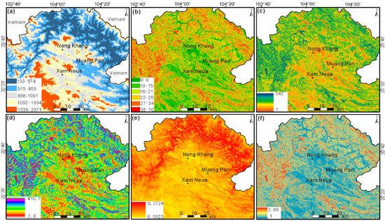
Figure 9.
Topographic factor analysis maps of the Houaphanh region: (a) elevation (m); (b) slope (°); (c) relief amplitude (m); (d) incision depth (m); (e) coefficient of elevation variation (dimensionless); (f) surface roughness (dimensionless).
4. Remote Sensing Interpretation Results
4.1. Lithological and Alteration Interpretation
Remote sensing interpretation shows that the Houaphanh region is dominated by Mesozoic argillaceous clastic rocks and widely distributed granitic intrusions. The Mz2 unit (red mudstone) is most extensive, occurring mainly in the central and northeastern parts of the study area, whereas Mz1 (argillaceous clastic rocks) and Pz1–Pz3 (Paleozoic sedimentary rocks) appear as smaller patches in the southwest and northeast (Figure 10a).
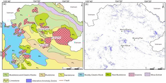
Figure 10.
Lithological and alteration interpretation results. (a) Integration of multi-source remote sensing band ratios with the geological and mineral map of Laos. (b) Distribution of alteration anomalies derived from principal component analysis.
Large granitic bodies are primarily exposed in the Nongkhang and Mengban areas, where they intrude the surrounding Mesozoic-Paleozoic strata (Figure 10a). These intrusions exhibit crosscutting relationships with surrounding Mz2, Mz1, and some Pz units. In addition, mica schist is mainly concentrated in the northeastern corner of the study area, forming continuous banded outcrops together with other Paleozoic strata.
Band ratio and PCA analyses highlight distinct alteration anomalies associated with these granitic exposures (Figure 10b). Iron-Oxide (Fe3+) and hydroxyl-bearing (Al-OH) anomalies exhibit strong spatial overlap, indicating zones of intense weathering and potential REE enrichment. Using the mean (μ) ± N × standard deviation (σ) classification, high anomaly intensities were concentrated around Nongkhang, Mengbang, and Xam Neua areas, consistent with the distribution of granitic parent rocks and favorable geomorphic conditions (Figure 8). These results suggest that lithological boundaries between granitic intrusions and surrounding clastic units represent key zones for the development of weathering crusts and secondary REE enrichment.
4.2. Results of Topographic Factor Analysis
Topographic analysis based on ASTER GDEM data reveals strong terrain variability across the study area. The landscape generally slopes from the southwest highlands to the northeast lowlands. (Figure 9a). The northwestern region exhibits high relief, deep incision, and pronounced roughness, typical of tectonic-erosional terrain (Figure 9b–f).
In contrast, the eastern and central regions, particularly the Nongkhang and Mengban areas, display moderate elevation, slope, and incision depth, forming gently undulating landforms favorable for regolith preservation.
Among the six analyzed parameters, elevation, slope, incision depth, relief amplitude, and surface roughness showed the strongest influence on regolith development, while the coefficient of elevation variation exhibited minimal variation and is therefore excluded from the final favorability model. The selected five factors were standardized and weighted equally to generate a topography-based metallogenic favorability map (Figure 11a). Areas satisfying all five favorable thresholds were extracted as geomorphically optimal zones for IREE mineralization (Figure 11b).
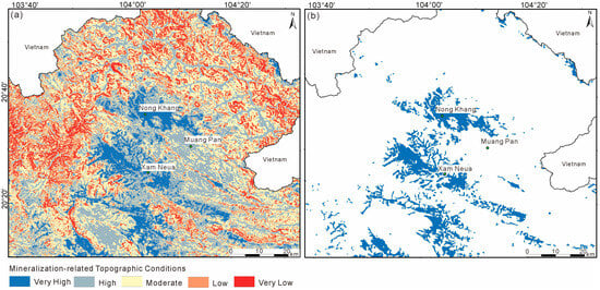
Figure 11.
Results of topographic factor analysis. (a) Mineral prospectivity index (red = low, blue = high). (b) Favorable metallogenic terrains identified in this study.
4.3. Integrated Interpretation Results
By integrating lithological, alteration, and topographic datasets, six prospective zones (b1–b6) were delineated across the study area (Figure 12). These targets represent regions where Fe3+ and hydroxyl anomalies coincide spatially with favorable geomorphic conditions.
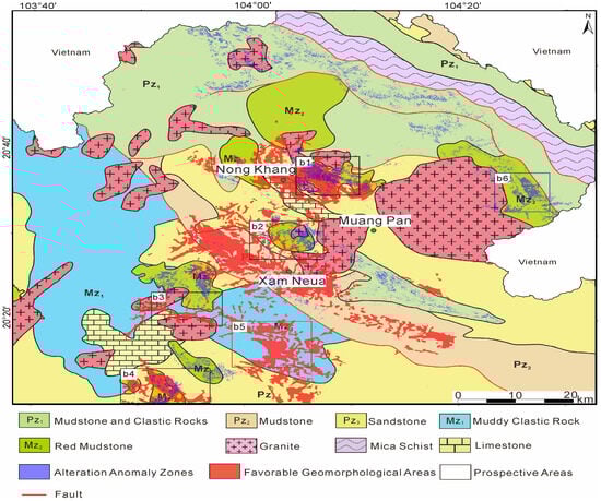
Figure 12.
Comprehensive overlay interpretation map integrating lithology, alteration anomalies, and topographic factors in the Houaphanh region.
Among them, Target b1, located in the Nongkhang area, represents the most prominent and spatially extensive anomaly. It occurs near granitic intrusions and red mudstone units, where strong alteration signatures and favorable topographic conditions indicate high exploration potential. Targets b2 and b3 share similar lithological and geomorphic characteristics with b1, displaying concentrated anomalies and moderate slopes that favor REE accumulation. In contrast, Target b4, situated at the southern margin of the study area, shows no clear surface exposure of granitic rocks; however, the presence of strong spectral anomalies suggests possible buried sources. Target b5, located south of Xam Neua, exhibits favorable topography but is affected by significant human disturbance and displays weak alteration anomalies, making it a lower-priority exploration target.
Finally, Target b6 lies in the easternmost part of the study area, where anomalies are limited and do not overlap with favorable geomorphic factors, indicating low metallogenic potential.
5. Prediction of Ion-Adsorption Type Rare Earth Deposits
5.1. Remote Sensing–Based Prospecting Model for Ion-Adsorption Type REEs
Integration of spectral indices and topographic factors revealed a clear spatial relationship between geomorphology, lithology, and alteration anomalies associated with IREE mineralization. High values of the Fe3+, clay mineral, and hydroxyl indices were consistently observed in areas where weathering crusts are well developed (Figure 10b). These anomalies commonly coincide with red mudstone and granitic units, confirming that such lithologies play a key role in REE enrichment (Figure 10a).
Topographic metrics related to elevation, gradient, and relief complexity exhibited a strong correlation with regolith development. Areas with moderate slopes, shallow incision depths, and gentle relief closely align with the most pronounced alteration anomalies, emphasizing the strong link between geomorphology and REE enrichment (Figure 9).
Overlay analysis combining these spectral and geomorphic datasets showed that Fe3+ and hydroxyl anomalies are found around granitic intrusions and sandstone zones, especially in favorable geomorphic areas (Figure 11). This relationship indicates a consistent spatial connection among four key elements: parent rock, weathering crust, alteration signal, and geomorphic background. The integrated interpretation offers a reliable remote sensing-based model for predicting IREE deposits in tropical regions.
5.2. Integrated Overlay Analysis and Validation of Prediction Results
Field verification was carried out in the Nongkhang area (target b1 in Figure 12), corresponding to the high-priority b1 target zone identified in the integrated analysis. Drilling data from 36 boreholes revealed 19 IREE ore bodies distributed across an area of approximately 3.547 km2 [7]. The medium- to high-grade mineralization zones closely align with areas showing high values in the clay mineral, Fe3+, silicate, and mafic indices (Figure 13c).
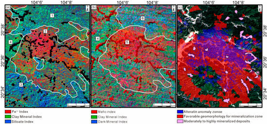
Figure 13.
Composite images and field validation of mineral targets. (a) False-color composite image (R: Fe3+ Index, G: Clay Mineral Index, B: Silicate Index). (b) False-color composite image (R: Mafic Index, G: Clay Mineral Index, B: Dark Mineral Index). (c) Landsat 9 image showing alteration anomaly zones, favorable metallogenic terrains, and confirmed medium- to high-grade mineralization sites from field validation. The numbers in Figure 13a,b represent: 1: Section of weathered basaltic sandstone; 2: Areas with high Fe3+ index and high clay mineral index; 3: Areas with medium-acidic intrusive rocks; 4: Areas with high clay mineral index; 5: Areas with high magnesium-iron index; 6: Areas with high dark mineral index; The white lines represent the boundaries between different regions.
Comparison between false color composites images (Figure 13a,b) and spatial distribution of medium- to high-grade mineralization (Figure 13c) indicates that most mineralized bodies occur within regions of strong alteration response and favorable topography. Of the 19 confirmed ore bodies, 16 are located within topographically suitable zones characterized by moderate slopes and low depths, further validating the reliability of the integrated model.
High values of the clay mineral, silicate, and dark mineral indices are observed in the zones represented by Figure 13a-1 and Figure 13b-6. Although the lithology is dominated by granite, these areas lie outside the favorable topographic range, and only four medium- to high-grade mineralized points were identified, suggesting that geomorphic conditions limited the development of weathering crusts. In contrast, zones corresponding to Figure 13a-2 and Figure 13b-5 display high Fe3+, clay mineral, and mafic index values, appearing as red-to-orange anomalies in the FCC imagery. Nine (09) REE ore bodies were delineated in these zones, indicating strong mineralization potential. The spatial coincidence of Fe3+ and mafic index highs reflects intense weathering, while their overlap with favorable topographic factors supports the formation of weathering-crust-type–type REE deposits.
At the southernmost part of the Nongkhang region (area 3), the silicate index shows high values, but Fe3+ responses and iron-staining anomalies are weak, and only four mineralized points were found. This suggests that, although the area is underlain by intermediate-acidic intrusive rocks, the degree of weathering is insufficient to produce a thick weathering crust capable of REE enrichment.
Overall, the strong correspondence between predicted high-favorability zones and field validation results confirms the accuracy of the integrated remote sensing and topographic approach. The findings demonstrate that both alteration intensity and geomorphic stability are critical for the formation of ion-adsorption-type REE deposits, and the applied method provides a rapid, cost-effective tool for identifying IREE targets in tropical, densely vegetated terrains.
6. Conclusions
- Lithological and alteration information derived from ASTER and Landsat 9 imagery using band ratio and principal component analysis (PCA) effectively identified granitic and weathered crustal zones favorable for REE enrichment. When combined with key geomorphological parameters extracted from DEM data, these datasets provided a comprehensive framework for delineating potential mineralization zones
- The integrated analysis revealed strong consistency among lithological, alteration, and topographic indicators, defining six prospective areas. Field validation in the Nongkhang zone confirmed 19 IREE ore bodies within the predicted high-favorability zone, demonstrating the accuracy and practical applicability of this method. Integrating spectral and geomorphological information enhances the prediction of regolith-hosted REE deposits, particularly in tropical, densely vegetated regions where traditional surveys are constrained. Future work should incorporate higher-resolution hyperspectral data and advanced machine learning algorithms to refine the model further and improve exploration efficiency.
- Integrating spectral and geomorphological information enhances the prediction of regolith-hosted REE deposits, particularly in tropical, densely vegetated regions where traditional surveys are constrained. Future work should incorporate higher-resolution hyperspectral data and advanced machine learning algorithms to refine the model further and enhance prediction accuracy.
Author Contributions
Conceptualization, Y.Y.; Methodology, C.L., X.Y. and W.S.; Formal analysis, Y.X.; Investigation, X.Y., W.S., Y.X., Y.Q. and C.Y.; Data curation, Y.Y., X.Y., O.R.V.Z., W.S., Y.Q. and C.Y.; Writing—original draft, Y.Y., C.L., X.Y. and O.R.V.Z.; Supervision, Y.Y. All authors have read and agreed to the published version of the manuscript.
Funding
This research was financially supported by Deep Earth Probe and Mineral Resources Exploration—National Science and Technology Major Project, No. 2025ZD1006600 (2025ZD1006602), the China Geological Survey Project (Grant No. DD20230900109), the National Natural Science Foundation of China (Grant No. 42302068), and the Sichuan Provincial Natural Science Foundation for Young Scholars (Grant No. 24NSFSC0820).
Data Availability Statement
No new data were created or analyzed in this study.
Conflicts of Interest
The authors declare no conflict of interest.
References
- Trench, A.; Zhang, L.; Groves, D.I.; Crook, D.; Brand, N.W. Australian Critical Metal Exploration for Analogues of Chinese Ionic-Clay REE Deposits. Geosyst. Geoenviron. 2025, 4, 100293. [Google Scholar] [CrossRef]
- Diao, H.; Yang, H.; Tan, T.; Ren, G.; You, M.; Wu, L.; Yang, M.; Bai, Y.; Xia, S.; Song, S.; et al. Navigating the Rare Earth Elements Landscape: Challenges, Innovations, and Sustainability. Miner. Eng. 2024, 216, 108889. [Google Scholar] [CrossRef]
- Liu, W.; Li, Y.; Wang, X.; Cui, L.; Zhao, Z.; Liu, C.; Xu, Z. Weathering Stage and Topographic Control on Rare Earth Element (REE) Behavior: New Constraints from a Deeply Weathered Granite Hill. Chem. Geol. 2022, 610, 121066. [Google Scholar] [CrossRef]
- Han, Z.; Lu, H.; Zhang, B.; Cheng, Z.; Fu, W.; Lao, C.; Xu, C. Delineating Preliminary Prospective Areas of Ion-Adsorption Rare Earth Deposits with Stream Sediments Geochemical Mapping in South China. J. Asian Earth Sci. 2023, 243, 105520. [Google Scholar] [CrossRef]
- Tian, S.; Liu, Z.; Mao, Q.; Ye, H.; Tian, C.; Zhu, Y.; Zhang, L. Leaching Characteristics and Environmental Impact of Heavy Metals in Tailings under Rainfall Conditions: A Case Study of an Ion-Adsorption Rare Earth Mining Area. Ecotoxicol. Environ. Saf. 2024, 281, 116642. [Google Scholar] [CrossRef] [PubMed]
- Amer, R.; Kusky, T.M. ASTER Analysis for Locating REE-Bearing Granites in Arid Regions: Example from the Arabian Shield. J. Earth Sci. 2022, 33, 1114–1123. [Google Scholar] [CrossRef]
- Lü, L.; Wang, S.; Zu, B.; Liu, J.; Zhang, G. Rare Earth Resources in Laos: Characteristics and the Prospects for Exploration and Development. Geol. Sci. Bull. 2022, 41, 20–31. [Google Scholar] [CrossRef]
- Wang, H.; Ling, F.C.; Li, X.Z.; Shi, M. The Division of Tectonic Units and Tectonic Evolution in Laos and Its Adjacent Regions. Geol. China 2015, 42, 71–84. (In Chinese) [Google Scholar]
- Rezaei, M.; Sanchez-Lecuona, G.; Abdolazimi, O. A Cross-Disciplinary Review of Rare Earth Elements: Deposit Types, Mineralogy, Machine Learning, Environmental Impact, and Recycling. Minerals 2025, 15, 720. [Google Scholar] [CrossRef]
- Chen, P.; Ilton, E.S.; Wang, Z.; Rosso, K.M.; Zhang, X. Global Rare Earth Element Resources: A Concise Review. Appl. Geochem. 2024, 175, 106158. [Google Scholar] [CrossRef]
- Cunningham, S.; Grammatikopoulos, T.; Almusned, B.; Henderson, J.D.; Azimi, G. Comprehensive Characterization and Extraction Implications of Ion Adsorption Rare Earth Deposit from a South American Source. Sci. Rep. 2025, 15, 29022. [Google Scholar] [CrossRef]
- Wu, P.; Li, X.; Liang, X.; Lin, X.; Zhu, J. Optimized Quantitative Analysis of Rare Earth Elements Associated with Typical Secondary Minerals in Regolith-Hosted Deposits. Chem. Geol. 2025, 691, 122942. [Google Scholar] [CrossRef]
- Guha, A.; Vinod Kumar, K. New ASTER Derived Thermal Indices to Delineate Mineralogy of Different Granitoids of an Archaean Craton and Analysis of Their Potentials with Reference to Ninomiya’s Indices for Delineating Quartz and Mafic Minerals of Granitoids—An Analysis in Dharwar Craton, India. Ore Geol. Rev. 2016, 74, 76–87. [Google Scholar] [CrossRef]
- Li, B.; Xie, H.; Liu, S.; Ye, Z.; Hong, Z.; Weng, Q.; Sun, Y.; Xu, Q.; Tong, X. Global Digital Elevation Model (GDEM) Product Generation by Correcting ASTER GDEM Elevation with ICESat-2 Altimeter Data. Earth Syst. Sci. Data 2025, 17, 205–220. [Google Scholar] [CrossRef]
- Kumar, C.; Chatterjee, S.; Oommen, T.; Guha, A. Automated Lithological Mapping by Integrating Spectral Enhancement Techniques and Machine Learning Algorithms Using AVIRIS-NG Hyperspectral Data in Gold-Bearing Granite-Greenstone Rocks in Hutti, India. Int. J. Appl. Earth Obs. Geoinf. 2020, 86, 102006. [Google Scholar] [CrossRef]
- Osinowo, O.O.; Gomy, A.; Isseini, M. Mapping Hydrothermal Alteration Mineral Deposits from Landsat 8 Satellite Data in Pala, Mayo Kebbi Region, Southwestern Chad. Sci. Afr. 2021, 11, e00687. [Google Scholar] [CrossRef]
- Yao, J.; Chao-lu, Y.; Ping, F. Evaluation of the Accuracy of SRTM3 and ASTER GDEM in the Tibetan Plateau Mountain Ranges. E3S Web Conf. 2020, 206, 01027. [Google Scholar] [CrossRef]
- Abdelkader, M.A.; Watanabe, Y.; Shebl, A.; El-Dokouny, H.A.; Dawoud, M.; Csámer, Á. Effective Delineation of Rare Metal-Bearing Granites from Remote Sensing Data Using Machine Learning Methods: A Case Study from the Umm Naggat Area, Central Eastern Desert, Egypt. Ore Geol. Rev. 2022, 150, 105184. [Google Scholar] [CrossRef]
- Gopinathan, P.; Parthiban, S.; Magendran, T.; Fadhil Al-Quraishi, A.M.; Singh, A.K.; Singh, P.K. Mapping of Ferric(Fe3+) and Ferrous(Fe2+) Iron Oxides Distribution Using Band Ratio Techniques with ASTER Data and Geochemistry of Kanjamalai and Godumalai, Tamil Nadu, South India. Remote Sens. Appl. Soc. Environ. 2020, 18, 100306. [Google Scholar] [CrossRef]
- Li, X.; Liu, X.; Jia, Z. DEM Geomorphological Features and Topographical Factor Analysis of Ion Adsorption Rare Earth Deposits in South China. South China Geol. 2023, 39, 376–386. [Google Scholar]
- Masek, J.G.; Wulder, M.A.; Markham, B.; McCorkel, J.; Crawford, C.J.; Storey, J.; Jenstrom, D.T. Landsat 9: Empowering Open Science and Applications through Continuity. Remote Sens. Environ. 2020, 248, 111968. [Google Scholar] [CrossRef]
- Shirmard, H.; Farahbakhsh, E.; Beiranvand Pour, A.; Muslim, A.M.; Müller, R.D.; Chandra, R. Integration of Selective Dimensionality Reduction Techniques for Mineral Exploration Using ASTER Satellite Data. Remote Sens. 2020, 12, 1261. [Google Scholar] [CrossRef]
- Zhao, C.; Xiao, Z.; Zhang, Y.; Yuan, C.; Yang, J. Alteration Mineral Information Extraction Based on Image Super-Resolution Technology. Int. J. Appl. Earth Obs. Geoinf. 2025, 144, 104872. [Google Scholar] [CrossRef]
- Zhang, T.; Zhao, Z.; Dong, P.; Tang, B.-H.; Zhang, G.; Feng, L.; Zhang, X. Rapid Lithological Mapping Using Multi-Source Remote Sensing Data Fusion and Automatic Sample Generation Strategy. Int. J. Digit. Earth 2024, 17, 2420824. [Google Scholar] [CrossRef]
- Ibrahim, M.; Al-Mashaqbah, A.; Koch, B.; Datta, P. An Evaluation of Available Digital Elevation Models (DEMs) for Geomorphological Feature Analysis. Environ. Earth Sci. 2020, 79, 336. [Google Scholar] [CrossRef]
- Wei, Y.; Gan, S.; Yuan, X.; Hu, L.; Gao, S. Analysis of Topographic Feature Parameters of Dinosaur Valley Ring Tectonic Geomorphology Based on the Advanced Land Observing Satellite Digital Elevation Model (ALOS DEM). Appl. Sci. 2023, 13, 13137. [Google Scholar] [CrossRef]
- Han, X.; Zhou, C.; Sun, S.; Lyu, C.; Gao, M.; He, X. An Ensemble Learning Framework for Generating High-Resolution Regional DEMs Considering Geographical Zoning. ISPRS J. Photogramm. Remote Sens. 2025, 221, 363–383. [Google Scholar] [CrossRef]
- Maxwell, A.E.; Shobe, C.M. Land-Surface Parameters for Spatial Predictive Mapping and Modeling. Earth-Sci. Rev. 2022, 226, 103944. [Google Scholar] [CrossRef]
- Hu, J.; Zhang, D.; Zhou, J.-X.; Wang, M. Identification of Regolith-Hosted Nb-REE Deposits in Alkaline Rocks Using Multisource Spectroscopic System: A Case Study of the Puxiong Deposit, Yunnan Province, China. Ore Geol. Rev. 2025, 186, 106860. [Google Scholar] [CrossRef]
- Huang, D.; Su, L.; Zhou, L.; Tian, Y.; Fan, H. Assessment of Gully Erosion Susceptibility Using Different DEM-Derived Topographic Factors in the Black Soil Region of Northeast China. Int. Soil Water Conserv. Res. 2023, 11, 97–111. [Google Scholar] [CrossRef]
Disclaimer/Publisher’s Note: The statements, opinions and data contained in all publications are solely those of the individual author(s) and contributor(s) and not of MDPI and/or the editor(s). MDPI and/or the editor(s) disclaim responsibility for any injury to people or property resulting from any ideas, methods, instructions or products referred to in the content. |
© 2025 by the authors. Licensee MDPI, Basel, Switzerland. This article is an open access article distributed under the terms and conditions of the Creative Commons Attribution (CC BY) license (https://creativecommons.org/licenses/by/4.0/).