Abstract
The purpose of this study is to explore and analyse user perceptions of peri-rural landscapes in the Seoul metropolitan region, using Icheon City as a case study. While the multifunctionality of peri-rural areas—providing ecological, cultural, and socioeconomic benefits—is increasingly recognised, the perceptual and experiential dimensions remain underexplored in South Korea. To address this gap, 10,578 Naver Blog posts were collected and refined, resulting in 8078 valid entries. Methodologically, this study introduces an innovative approach by integrating centrality analysis with latent Dirichlet allocation (LDA) topic modeling of user-generated content, supported by a bespoke dictionary of 170 local landscape resources. This combined framework allows simultaneous examination of structural associations and thematic narratives within user perceptions. The results indicate that resources such as Seolbong Urban Park, Seolbong Mountain, and the Cornus Fruit (sansuyu) Villages function as symbolic hubs in the perceptual network, while thematic clusters capture multi-dimensional concerns spanning leisure, ecology, culture, suburbanization, and real estate. Synthesised together, these findings demonstrate that user perceptions construct peri-rural landscapes not as isolated sites, but as spatially cohesive and thematically interconnected systems that mediate between urban and rural domains. Overall, this study contributes to metropolitan planning discourse by highlighting perceptual dimensions alongside functional and ecological dimensions. It shows that users cognitively construct peri-rural landscapes as systems that are both spatially cohesive and thematically interconnected, and that function as spaces that link urban and rural areas. Crucially, this study provides a replicable framework for using user-generated content to inform the planning and management of peri-rural landscapes in metropolitan areas.
1. Introduction
As Simon (2008) observed, peri-rural areas have historically functioned as hinterlands, supporting urban ecosystems through agricultural production and ecological resources [1]. In contemporary metropolitan regions, however, these areas have shifted from peripheral zones to integral components of the socio-ecological fabric of mega-cities such as Seoul and Busan. In Korea, rural and peri-rural landscapes are characterized by multifunctional roles, such as agricultural production, ecological regulation, and cultural identity, alongside increasing pressures from suburbanization and real estate development. These characteristics position peri-rural spaces as essential mediating zones between urban growth and rural continuity.
International scholarship has highlighted the multifunctional roles of peri-rural landscapes, emphasizing the perceived benefits humans derive from them. European studies focus on cultural ecosystem services and quality-of-life improvements [2,3,4], while Asian and global research points to socio-cultural meaning, governance challenges, and place-based experiences in metropolitan hinterlands [5,6,7]. Collectively, these studies underscore that understanding user perceptions is central to sustainable metropolitan landscape planning, extending beyond ecological or economic valuation.
By contrast, in South Korea, peri-rural landscape research has primarily emphasized economic valuation or ecological assessments [8,9], with relatively few studies addressing how these landscapes are perceived and experienced by users [10]. This gap is significant, as aligning metropolitan planning with public values requires attention not only to functional benefits but also to lived experiences and cultural meanings.
In light of this, the objective of this study is to empirically examine the perceptual structures and spatial significance of peri-rural natural landscapes in the metropolitan region. Specifically, this study seeks to answer three questions:
- (1)
- Which natural landscape resources in peri-rural sites emerge as structurally central within user-generated narratives, and how can these be interpreted as indicators of cognitive influence?
- (2)
- What thematic communities and clusters of perceived value are revealed through the integration of network centrality and topic modeling?
- (3)
- How do these perceptual and thematic structures correspond to the spatial hierarchy and connectivity of peri-rural resource spaces? How can this correspondence be interpreted within the broader discourse on rural–urban linkages?
To address these inquiries, this study analyzes large-scale user-generated content (UGC) from Naver Blog using text mining, eigenvector centrality, community detection, and topic modeling. This mixed computational approach demonstrates how peri-rural landscapes function simultaneously as network hubs and semantic anchors in collective user narratives. In doing so, this study contributes to international discourse on peri-rural landscapes by highlighting their role as mediating systems connecting urban and rural areas, while offering practical insights for developing integrated and context-sensitive strategies for sustainable metropolitan landscape planning.
2. Literature Review
Historically, rural areas surrounding cities functioned as hinterlands, supplying labor and agricultural products to urban cores while receiving benefits from urban amenities [11]. However, with the rise in environmental consciousness and the rapid progression of digital transformation, rural regions have evolved from mere peripheries to dynamic spaces of exchange, where goods, services, and ecological benefits are exchanged between urban and rural systems [12,13]. In this context, peri-rural areas are increasingly recognized as active mediators that sustain urban–rural linkages and facilitate integrated regional development [13,14].
The terms “peri-urban” and “peri-rural” are frequently employed to denote the transitional zones between urban and rural areas [15,16]. Peri-urban areas are characterized by the expansion of urbanization along the urban edge, where various land uses such as housing, industry, and residual agriculture become intermingled. This concept is widely applied in the fields of urban studies and urban planning [17,18]. Conversely, peri-rural areas underscore the rural dimension of this interface, emphasizing how rural landscapes adjacent to metropolitan regions continue to be influenced by agricultural production, cultural identity, and community life, despite their gradual integration into urban influences [19].
While the spatial scope of these two concepts largely overlaps—for instance, regions such as Icheon or Namyangju in the Seoul metropolitan periphery may be described in both terms—the distinction lies in perspective: peri-urban when focusing on urban expansion and sprawl, and peri-rural when emphasizing the multifunctional values and integrity of rural landscapes. In this study, the term “peri-rural area” is employed to underscore the multifunctionality of rural landscapes within Functional Urban Areas (FUAs) and to highlight their ecological, cultural, and experiential significance in metropolitan contexts.
The notion of functional regions has a long and rich history in geographical scholarship, dating back to the early 20th century, long before its mainstreaming in policy documents. Conventional research has placed significant emphasis on the concept of functional regions as spatial domains characterized by elevated internal interactions, such as commuting patterns, labor markets, and economic flows. In contrast to administrative boundaries, these functional regions are defined by the high degree of internal interaction they exhibit [20,21]. This tradition has evolved through the application of optimization approaches that utilize journey-to-work data [22] and, more recently, digital sources such as points of interest and social media traces [23].
Contemporary policy frameworks draw from this scholarly tradition by using Functional Urban Areas (FUAs) to analyze urban–rural integration. FUAs encompass urban cores and their commuting zones [24,25,26,27,28]. Research on FUAs emphasizes the interconnectedness of urban and rural systems, demonstrating how commuting, investment, environmental resources, and governance partnerships transcend administrative borders [29,30]. Evidence from European megacity regions shows that geographically dispersed centers can form integrated systems that boost economic vitality and quality of life [25,27]. In this context, peri-urban areas are strategically significant because they alleviate environmental pressures, buffer population density, and provide ecosystem services, thereby sustaining balanced socioeconomic and ecological development [26,31].
Research on peri-rural landscapes has also expanded significantly on an international scale, with three predominant emphases. European studies have emphasized multifunctionality and ecosystem services, including climate regulation, food provision, recreation, and cultural values [2,3,4]. Secondly, Asian scholarship, particularly in Japan and China, underscores socio-cultural values and agricultural sustainability. It also identifies risks of urban sprawl, such as farmland loss and food system disruption [5,6,32,33]. Thirdly, research from India, Africa, and Southeast Asia emphasizes the role of peri-urban agriculture in food security, biodiversity, and resilience, mitigating risks posed by rapid urban expansion [7,29,34]. A collective examination of this literature reveals that peri-rural landscapes function as multifunctional spaces, where cultural values, user experiences, and sustainability concerns converge.
In addition, methodological innovation has further diversified approaches to studying perception. Komossa et al. (2020) compared participatory methods (e.g., mapping, photo ranking) with digital approaches such as the analysis of social media tags [35]. Their findings demonstrated that the latter, namely digital approaches using social media data, yielded large-scale behavioral traces, albeit with sampling biases. In a similar vein, Oteros-Rozas et al. (2018) [36], Van Zanten et al. (2016) [37], and Wartmann & Purves (2018) [38] have demonstrated the potential of user-generated content (UGC) for analyzing preferences and spatial choices at scales unattainable by conventional surveys. In doing so, Text mining has emerged as a valuable tool for revealing latent meanings in public discourse, complementing experiential and participatory approaches.
Confronted with this international context, Korean research has historically remained comparatively narrow in scope. Earlier studies primarily focused on economic and ecological valuation. For instance, Kwak et al. (2003) estimated the annual conservation value of Mt. Gwanggyo’s forests at KRW 3.77 billion [8], and Im and Lee (2004), applying contingent valuation, calculated the multifunctional value of rural landscapes at KRW 1.32 trillion [9]. While these studies established significant benchmarks, they placed considerable emphasis on instrumental valuation, neglecting to incorporate subjective or experiential dimensions. In a recent study, Lee (2020) examined the perceptions of Sansuyu (Cornus fruit) Village in Icheon [10]. The study found that long-term residents placed a higher value on relational and experiential connections, while non-residents prioritized visual and functional aspects. Despite its insightful nature, the present qualitative study was constrained in its scope and generalizability.
A synthesis of the extant literature suggests two key points. First, internationally, peri-rural landscapes are increasingly regarded as multifunctional spaces where ecological services, cultural meanings, and user experiences intersect. This phenomenon has been analyzed using diverse methodologies, ranging from participatory engagement to large-scale UGC analysis. Secondly, the field of Korean scholarship has yet to adequately address the perceptual and experiential dimensions, remaining predominantly focused on economic valuation or case-specific insights. This research gap underscores the necessity to contextualize Korean peri-rural landscapes within global discourses, transcending the confines of instrumental valuation to encompass perceptions and cultural significations influenced by accelerated urbanization and socio-cultural transformation.
Accordingly, the present study employs user-generated content (UGC) to examine public perceptions of peri-rural landscapes in the Seoul metropolitan region, focusing on Icheon City as a representative case. It identifies both the structural prominence of key resources and the thematic clusters of meaning that shape how these landscapes are valued. The study goes beyond conventional economic and ecological assessments, emphasizing experiential values that are frequently underappreciated in planning processes. This approach contributes to the advancement of understanding of peri-rural landscapes as mediating systems between urban and rural spheres. It also offers insights for more integrated and spatial context-sensitive metropolitan landscape planning.
3. Materials and Methods
3.1. Study Area
This study focuses on Icheon City, a peri-urban area located approximately 50 km southeast of central Seoul, South Korea (see Figure 1). Icheon benefits from a well-connected transportation infrastructure and is situated on the fringe of the Greater Seoul Region. This location offers both excellent accessibility and rich ecological diversity.
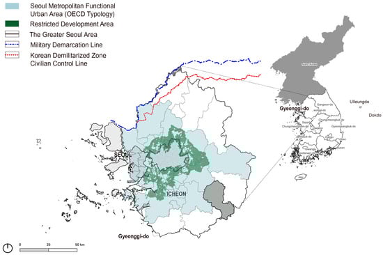
Figure 1.
Study area.
Administratively, Icheon is a mixed urban–rural municipality. Only 17.8% of its total area (461.2 km2) is designated as urban; the remainder consists largely of agricultural land, forests, and managed natural areas, highlighting its strong rural character. The region is known for its rice, peaches, and traditional horticultural crops and features diverse rural landscapes, including mountain ranges and river systems.
According to the OECD territorial typology, Korea’s TL3 regions are categorized as predominantly urban (PU), intermediate (IN), or predominantly rural (PR). PR areas are further divided into those that are closer to and those that are more remote from cities. All five of Korea’s PR regions are classified as “predominantly rural, closer to a city,” and Icheon is one of them [39,40].
However, under the OECD Functional Urban Area (FUA) delineation based on commuting flows, Icheon currently lies outside the FUA boundary (commuters to the core < 5%), corresponding to the far-from-FUA rural. Nevertheless, Icheon’s functional ties with the Greater Seoul Region are intensifying due to recent metropolitan rail extensions and the relocation and expansion of industrial estates. This suggests a plausible expansion of the effective FUA envelope over time. This evolving connectivity underscores Icheon’s relevance as a peri-rural case at the metropolitan fringe, retaining strong agricultural and ecological functions while interacting increasingly with metropolitan economic and infrastructural systems.
In regional development plans, Icheon is positioned as a strategic hub within the “Smart Semiconductor Belt” and the “Green Tourism–Agriculture Belt,” combining advanced manufacturing with cultural and ecological tourism. The city comprises four functional zones—north, south, east, and west—each with distinct features, such as artistic rural communities, industrial clusters, agritourism, and logistics and leisure areas. This spatial diversity makes Icheon a representative case for exploring the multifunctional role of peri-rural landscapes and their perceived value among metropolitan users.
3.2. Study Flow
- Step 1. Text Data Collection and Preprocessing
Text mining refers to the process of transforming unstructured textual data into structured formats using natural language processing (NLP) techniques, which is then followed by the application of statistical or machine learning methods to identify patterns and extract insights relevant to the research objective” [41,42].
In this study, Naver Blog—a user-driven search and social media platform—was selected as the primary data source. Blog posts are suitable for this research as they are typically created voluntarily and describe personal experiences, allowing insight into actual user engagement with natural landscapes. However, it should be noted that the demographic characteristics of Naver Blog users may not be representative of the general population. The platform tends to attract younger, urban and digitally proficient groups, which has the potential to distort the perspectives documented in this dataset.
Data collection was conducted using a web crawler developed with Python 3.11.8, including Beautiful Soup 4 and Selenium. The primary search terms were combinations of “Icheon City” with five resource-oriented keywords: natural environment, green space, urban park, ecology, and river. The Keyword selection was intentionally restricted to resource-based descriptors rather than activity-based terms (e.g., camping, hiking), in order to capture a broad spectrum of natural landscape resources themselves. This prioritization reflects the central objective of the study: to delineate perceptual structures surrounding the landscape assets rather than specific user practices. Activity-oriented keywords, while useful for investigating leisure behaviors, risk skewing the dataset toward tourism- or recreation-driven narratives and underrepresenting the broader ecological and cultural dimensions of peri-rural landscapes. By contrast, resource-based descriptors allow for the construction of a perceptual network that emphasizes the spatial and symbolic associations of natural assets, thereby ensuring conceptual consistency with the research aim. While activity-related keywords might provide insights into specific practices of use, the primary objective of this study was to first delineate how natural landscape assets are perceived in online discourse. This focus, however, is acknowledged as a limitation and points to future research opportunities.
The collection period spanned from 1 January 2023 to 31 July 2024, yielding a total of 10,578 blog entries. A two-stage filtering process was then applied. First, duplicate entries (e.g., identical content by the same author on the same date) were removed using Python scripts, reducing the dataset to 10,094 posts. Second, the researcher manually filtered out irrelevant posts based on low keyword relevance, resulting in a final dataset of 8078 valid posts (Table 1). To avoid conceptual conflation, resources were distinguished post hoc by qualitatively classifying place-related keywords into two categories: natural (e.g., rivers, mountains, forests, green spaces) and cultural/artificial (e.g., amusement parks, art museums, heritage sites). While both types appeared in the dataset, the analysis primarily focused on natural resources, whereas cultural resources were only noted for classification purposes.

Table 1.
Number of Blog Posts Collected and Processed by Keyword.
To prepare the unstructured text data for analysis, preprocessing involved cleaning, tokenization, normalization, and part-of-speech (POS) tagging1. A custom user dictionary was developed to enhance accuracy, comprising four components: (1) a defined word list to retain proper nouns and compound terms, (2) a thesaurus for unifying synonyms, abbreviations, and colloquialisms, (3) a stopword list to remove irrelevant or filler words, and (4) a spam-word list to filter out promotional or unrelated content (Figure 2).
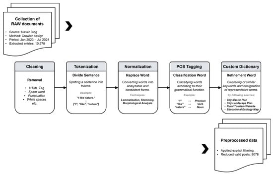
Figure 2.
Text Data Collection and Preprocessing flow.
The proper noun dictionary ensured that compound place names and landmarks were preserved as indivisible tokens (e.g., “Seolbong Mountain Park [설봉산공원]” was retained as a single token rather than split into “Seolbong” and “Park”). The synonym dictionary standardized variations in naming conventions by merging colloquial, abbreviated, or alternative expressions into one representative form (e.g., “the Cornus fruit village [산수유마을], the Cornus village street [산수유 마을길], the Cornus Festival village [산수유축제마을]” → “the Cornus village [산수유마을]”). The stopword dictionary removed frequently occurring but semantically irrelevant words (e.g., “today,” “then,” “so”) as well as blog-specific expressions (e.g., “subscribe,” “hashtag,” “see more”). Finally, the spam-word dictionary excluded posts containing terms that overlapped morphologically with core keywords but were unrelated to the study context, such as “industrial ecosystem [산업생태계]” (economic context), “natural eyelashes [자연 속눈썹]” (cosmetic advertising), and “natural drying [자연건조]” (product descriptions).
Following this process, only nouns were extracted for analysis, reflecting the linguistic characteristics of Korean, where endings and particles often obscure semantic content. By focusing on nouns, the analysis maximized semantic clarity in capturing landscape-related perceptions.
- Step 2. Development of a User Dictionary for Natural Landscape Resources in Icheon
The aim here is to create a specialized dictionary tailored to the natural landscape resources of Icheon. Keywords and concepts related to the local natural environment were compiled, and similar terms were clustered to establish representative expressions. By refining the vocabulary set, the analysis gains higher precision in capturing resource-related mentions, thereby reflecting the unique landscape characteristics of the study area.
To support keyword-based analysis, a customized dictionary of natural landscape resources was constructed by following sources: the 2030 Icheon City Master Plan (2019) [43], the 2020 Icheon City Landscape Plan [44], the official website of the Icheon Rural Exchange Center (Icheon Nadeuri) [45], recommended tourist sites from the Icheon Education Office, and the Icheon Future Education Cooperation District’s ecological education maps [46] (Table 2). A thesaurus of alternative expressions was also developed to account for synonymous or context-specific variations in naming conventions. Using the initial dataset, facilities that had ceased operation by 2025 were filtered out, and a refined dictionary was developed. To ensure reliability, the dictionary was cross-checked by three independent experts in landscape planning and environmental studies and revised iteratively based on their feedback.
Table 2.
Sources and Datasets Collected for Preliminary Database Construction.
- Step 3. Centrality Analysis of Natural Landscape Resources
(a) Frequency and Centrality Analysis
This step aimed to identify which landscape resources were most prominent in user perceptions. User-generated content from Naver Blog was preprocessed through keyword extraction and dictionary matching, after which a co-occurrence matrix of terms was constructed. Co-occurrence was defined at the full-document level, such that two terms were considered co-occurring if they appeared at least once in the same blog post. While simple frequency analysis based on dictionary counts revealed basic mention patterns, it was insufficient for capturing the relational significance of terms. To address this limitation, a perceptual network of landscape resources in Icheon City was built using the Python NetworkX library.
To evaluate the structural importance of resources within this network, three centrality measures were applied: Degree Centrality (number of direct connections), Betweenness Centrality (intermediary role along shortest paths), and Eigenvector Centrality (influence through connections to other highly influential nodes). The analysis followed four main steps: (1) keyword extraction and dictionary matching, (2) construction of co-occurrence networks, (3) computation of centrality scores, and (4) visualization of the perceptual network community. This procedure allowed the identification of not only frequently mentioned resources but also those functioning as critical bridges or hubs in user perception, thereby highlighting their structural significance within the broader landscape network.
(b) Spatial Analysis Based on Centrality
The objective of this step is to investigate how important resources are distributed across space. Core keywords were matched with geographic information (place names and coordinates), and their spatial distribution was visualized through GIS mapping. Patterns of clustering and regional dominance were analyzed to uncover the relationship between perceptual centrality and the spatial organization of natural landscapes.
To investigate spatial patterns of perceived importance, the top 40 natural landscape assets identified through the network analysis were analyzed using their Eigenvector Centrality (EC) scores. Each asset listed in the user-defined landscape resource dictionary was geocoded using road addresses obtained from Google Maps APIs. The resulting geographic coordinates were then converted into the TM projection system (EPSG:5174–Korea 2000/Central Belt) for spatial analysis.
The spatial distribution of main resources was analyzed across Icheon’s living zones, examining patterns of clustering, density, and regional dominance to understand their relationship with landscape structure. Following geocoding, EC values were assigned as attribute data to each asset. These were then visualized on a map to illustrate their relative importance within the network. Resources with EC scores above 0.1 were categorized as “important,” and those above 0.2 as “highly important.” Visual symbology—such as node size and symbol differentiation—was used to depict the spatial hierarchy of landscape assets. This allowed for the identification of whether highly central resources were spatially clustered in specific subregions or dispersed throughout the city. For visualization, an EC cutoff of 0.15 was adopted as a balanced threshold: values below 0.10 included too many marginal nodes, while values above 0.20 left only a handful of hubs, thereby limiting interpretability. Accordingly, 0.15 served as a practical middle ground that highlighted key hubs while preserving the overall network structure. To assess robustness, alternative EC thresholds (0.10 and 0.20) as well as percentile-based cutoffs (top 20%, 15%, and 10% of EC values) were applied. Although the number of resources classified as important declined under stricter thresholds, the key hubs and their spatial clustering patterns remained consistent across all scenarios, confirming the stability and reproducibility of the results (Table 3). The robustness checks further indicated that, despite variations in the number of important resources across thresholds, the core hubs were consistently maintained. For example, the overlap between the reference cutoff (EC > 0.15) and alternative thresholds ranged from 27% to 53%—a moderate level of similarity that nevertheless always included top-ranked hubs such as Seolbong Park and Seolbong Mountain.
Table 3.
Robustness check of eigenvector centrality thresholds.
- Step 4. LDA Topic Modeling Analysis
The goal of this stage is to understand the thematic contexts in which natural landscapes are perceived. To achieve this, Latent Dirichlet Allocation (LDA) topic modeling was applied. LDA is a probabilistic algorithm that uncovers latent topics in a corpus by estimating the distribution of words across topics and the distribution of topics across documents [47]. In other words, it assumes that each document is a mixture of topics, and each topic is characterized by a set of words with specific probabilities. This structure is modeled through Dirichlet distributions, where the hyperparameters α and β, respectively, control the diversity of topics within documents and the concentration of words within topics [48].
For these steps, a refined dataset of 4073 user-generated documents related to Icheon’s peri-urban landscapes was used. Prior to topic modelling, an additional filtering process was applied to enhance the validity of the dataset. First, posts with low keyword relevance (e.g., lacking references to Icheon or natural landscapes) were excluded. Second, documents containing irrelevant or noisy expressions were removed using a spam word, which overlaps morphologically with ecological terms but is unrelated to landscape contexts. This process removed 4025 posts, resulting in a final corpus of 4073 valid entries. After all, the transformation into a Bag-of-Words (BoW) representation, which disregards word order but retains frequency information. Although TF–IDF weighting can be applied to adjust the relative importance of words, the BoW representation is more commonly used in LDA since the model focuses on estimating consistent topic distributions across the corpus [49]. The LDA model was trained using the Python Gensim library.
A critical step in topic modeling is determining the appropriate number of topics (K). This study employed perplexity and coherence scores as evaluation metrics. Perplexity assesses how well the trained Dirichlet model predicts the observed documents, with lower values indicating a better fit. However, perplexity alone often fails to capture interpretability, so coherence scores were additionally used. Coherence measures the degree of semantic similarity among high-probability words within each topic [50,51].
A coherence value above 0.6 is generally considered acceptable for interpretability. By balancing these two indices and qualitatively comparing interpretability across candidate models, the optimal solution of seven topics was identified, as shown in the results of Table 4.
Table 4.
Evaluation Results of Topic Number Appropriateness.
Each topic was then labeled and interpreted based on representative keywords and user narratives, allowing the extraction of experiential and perceptual meanings (e.g., tourism, leisure, healing, real estate). This thematic approach complements the preceding structural network analysis by providing a semantic layer that explains why specific landscape resources are perceived as important, rather than only how strongly they are structurally connected.
- Step 5. Integration and Interpretation
The final step integrates the structural and thematic dimensions of user perception. High-centrality perception themes were analyzed with representative keywords and narratives. By mapping central assets to related topics, the analysis links what is important (structural centrality) with why it is important (thematic context). This integrated approach provides a more comprehensive understanding of how peri-rural landscapes are perceived and valued (Figure 3).
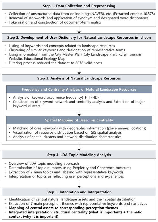
Figure 3.
Study Flow.
4. Results
4.1. Development of a Natural Landscape Resource Dictionary
Following expert validation, a user-defined dictionary of natural landscape resources was developed, consisting of 170 assets in Icheon City (Table 5, Figure 4). Based on this list, a centrality analysis was conducted. The most distinctive assets of Icheon’s natural landscape resources were forested mountainous areas, including the peaks of Wonjeok Mountain, Seolbong Mountain, Dodram Mountain, and Seolseong Mountain. In terms of hydrological features, the Bokha River, designated as a national river, flows from north to south through the city, while the Cheongmi River crosses its southern part.
Table 5.
Detailed List of Natural–Cultural Landscape Resources as of 2025.
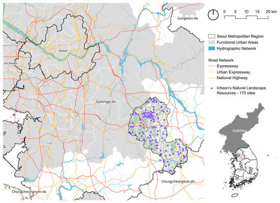
Figure 4.
Peri-rural Natural Landscape Resources within the Functional Urban Area (FUA) of the Seoul Metropolitan Region.
4.2. Centrality Analysis of Natural Landscape Resources
As shown in Table 6, the centrality analysis identified ‘Seolbong Urban Park’ as the most prominent landscape asset in Icheon, consistently ranking highest across all three centrality metrics—degree (0.656), betweenness (0.283), and eigenvector (0.303). Notably, its eigenvector score is more than twice the overall mean (0.143) and well above the median (0.129), underscoring its exceptional prominence within the perceptual network. This indicates that Seolbong Urban Park is not only highly connected but also strongly integrated within the broader perception network of influential assets, including Seolbong Mountain, which also demonstrated high centrality scores (degree: 0.516; eigenvector: 0.278).
Table 6.
Results of Centrality Analysis for Natural Landscape Resources in Icheon.
In contrast, although ‘Jungni River’ appeared frequently in the keyword analysis (417 mentions), its relatively low centrality values—degree (0.194), betweenness (0.0101), and eigenvector (0.119)—are close to the network median and below the mean, suggesting that it plays only a marginal role compared to the more influential hubs.
Meanwhile, Bokha River (eigenvector: 0.195), Noseong Mountain (0.218), and Cornus Fruit Village (0.206) also exhibited consistently high scores across centrality dimensions, highlighting their integrative functions and importance within the landscape cognition network.
4.3. Structural and Spatial Patterns of Natural Landscape Resources
- (a)
- Structural Patterns of Natural Landscape Resources
The network graph based on eigenvector centrality (Figure 5) not only visualizes the structural relationships among natural landscape resources but also demonstrates how a few highly central assets—such as Seolbong Urban Park and Seolbong Mountain—function as cognitive anchors that organize and connect user perceptions across the broader landscape network. Each node represents a landscape asset defined through the curated dictionary, while edges indicate co-occurrence relationships extracted from user narratives. Node size is proportional to the eigenvector centrality score, and nodes with scores exceeding 0.15 are rendered in bold to emphasize their relative importance.
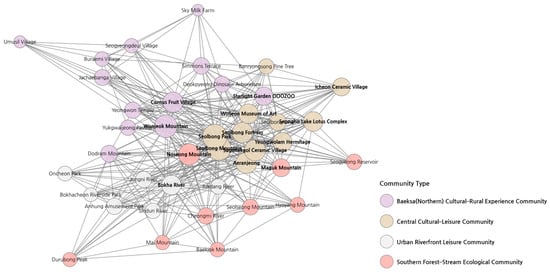
Figure 5.
Top 40 Keywords from Community Network Graph.
Here, eigenvector centrality is interpreted as a measure of ‘cognitive influence’ within the perception network. This term refers to the relative prominence of a resource in user-generated narratives: resources with high eigenvector centrality are not only frequently mentioned, but also strongly connected with other frequently mentioned resources. Such resources occupy central positions within the collective perceptual structure, indicating that they are key anchors in how natural landscapes are cognitively organized and remembered by the public.
Community detection using the Louvain algorithm identified four distinct communities. Thematic attributes were derived inductively by examining co-occurrence patterns of keywords within each cluster, followed by expert review that classified them into categories such as recreation, cultural-historical identity, and ecological value. In this study, cultural identity denotes the symbolic associations and local distinctiveness attached to certain resources (e.g., heritage sites) that reinforce Icheon’s sense of place.
- (b)
- Spatial Pattern Based on Centrality
The spatial analysis based on eigenvector centrality demonstrated that highly central landscape resources were not randomly dispersed but instead formed coherent network clusters based on shared spatial and contextual characteristics. Broadly, a dichotomy emerged between northern and southern living zones, with sub-clusters forming within each zone based on the functional types of landscape experiences (Figure 6).
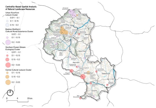
Figure 6.
Centrality-Based Spatial Analysis of Natural Landscape Resource.
Interestingly, the communities revealed through the Louvain algorithm were not only cohesive in terms of narrative associations but also demonstrated spatial correlations, as assets within the same community tended to be geographically proximate—for example, riverfront parks concentrated along the Bokha River or mountain–village complexes in northern Icheon.
For example, the Forest–Stream Ecological Landscape Cluster2 in the southern region includes Cheongmi River, Mai Mountain, and Baekjok Mountain, which collectively represent a linear ecological system aligned with mountain ridges and riparian corridors. Some natural assets, such as mountains and rivers that extend beyond Icheon’s administrative boundaries, were also included, as users consistently referenced them in connection with adjacent landscapes (e.g., Mai Mountain), reflecting the ecological and perceptual continuity of Icheon’s southern region.
In contrast, the Cultural-Leisure Cluster, situated along the urban fringe, is composed of highly interconnected leisure and cultural assets such as Seolbong Park, Icheon Ceramic Village, and Starlight Garden OOOZOO. These sites are located near the central area of Icheon and share a thematic orientation toward art, leisure, and peri-rural tourism, particularly featuring spaces designed for family and child-friendly nature-based experiences.
In addition, the northern part of Icheon—particularly the area surrounding Cornus Fruit Village—is characterized by cultural heritage sites, traditional rural experience villages, and culturally significant landscapes linked to Wonjeok Mountain. This area is perceived as a peri-rural region of high historical and natural landscape value.
Notably, assets distributed along the tributaries of the Bokha River form the Urban Riverfront Leisure Cluster, highlighting spatial concentrations of riverside parks and ecological greenways. This pattern suggests that users perceive riparian landscapes not as isolated features, but as integrated linear ecological systems.
These findings indicate that users do not perceive landscapes solely through individual sites, but rather through spatially cohesive and thematically interconnected community construction (Figure 6). Furthermore, the alignment between the network structure and physical geography—such as rivers, mountain ridges, and land use boundaries—demonstrates a high level of congruence between perceived and physical landscape systems. Through community detection, these networked associations were further interpreted in spatial terms, illustrating how narrative linkages among resources translate into coherent geographic clusters across Icheon’s peri-rural landscape.
4.4. Thematic Structures of User Narratives on Peri-Rural Landscapes
The topic modeling results, analyzed using keywords related to peri-rural natural landscape in the vicinity, were divided into seven topics. The derived topics were named and labeled by reviewing the 20 words with the highest probability for each topic.
To select representative documents, the topic assignment probability with the highest explanatory power was calculated for each document, and topics were assigned to the original texts for classification. Subsequently, the top 20 documents with the highest probabilities for each topic were extracted, and the original context was reviewed to interpret the topics.
As shown in Table 7, the LDA analysis of 4073 blog posts yielded seven dominant topics. The largest share was Topic 6 (Family tourism and culinary experiences, 20.67%), followed by Topic 1 (Suburbanization and real estate transactions, 17.16%) and Topic 7 (Cultural festivals and environmental improvement projects, 16.23%). Together, these themes demonstrate that user narratives about Icheon’s peri-rural landscapes are distributed across leisure, ecological, cultural, and development-related dimensions, revealing the multi-functional roles of peri-rural environments. In addition, some documents and topics also reflected concerns about landscape change in Icheon, particularly in relation to suburban expansion and rising real estate development (Topics 1, 3, and 4).
Table 7.
LDA Topic Modeling Results on Blog Posts Related to Icheon’s Peri-Rural Natural Landscapes.
4.5. Integration: Mapping Assets to Topics
The integration of eigenvector centrality results with LDA topic modeling provides deeper insights into how natural landscape resources are cognitively structured and discursively represented in Icheon’s peri-rural context. While the centrality analysis identified structurally important resources and their networked associations, the LDA analysis revealed seven dominant themes through which users frame their experiences and perceptions. By mapping high-centrality assets to these thematic topics, it becomes possible to explain not only what resources are central but also why they hold significance in user narratives.
Table 8 summarizes the overlap between the top 20 keywords derived from LDA topics and the resources that ranked highly in eigenvector centrality. Several of the most central assets in the perception network—such as Seolbong Mountain, Seolbong Park, Cornus fruit (Sansuyu) villages, and Icheon Ceramic Village—also appeared as salient keywords within the LDA topics.
Table 8.
Overview of LDA Topics, Overlapping Central Assets, and Corresponding Clusters.
As shown in Table 8, Seolbong Mountain and Seolbong Park emerged across multiple topics (1, 2, 3, 4, and 7), reinforcing their role as both ecological landmarks and cultural anchors in Icheon’s landscape narratives. Positioned within the Central Cultural–Leisure Cluster, these resources were simultaneously framed in economic discourses of suburbanization and real estate, as well as in cultural-historical contexts of festivals and environmental projects, demonstrating their multifaceted symbolic value.
Similarly, Cornus fruit (Sansuyu) villages and ceramics were closely tied to Topics 5 and 7, with assets distributed across the Southern Forest–Stream Ecological Cluster and the Baeksa Cultural–Rural Experience Cluster. This illustrates how seasonal landscapes and traditional industries serve as anchors of regional identity and collective memory.
In addition, leisure-oriented central assets such as Simmons Terrace, PiaTtil Pig Museum, and Dinosaur Arboretum—belonging to the Central Cultural–Leisure Cluster—were strongly associated with Topic 6 (Family tourism and culinary experiences), reflecting their role as hubs for family-oriented leisure and peri-rural recreation.
These overlaps indicate that resources positioned at the structural center of the perception network are also embedded within dominant perceptual themes that shape user engagement. Taken together, the integration of centrality analysis, community detection, and topic modeling demonstrates that high-centrality resources function not only as network hubs but also as semantic anchors in user narratives. This dual significance strengthens the interpretation that peri-rural landscapes in Icheon are cognitively constructed through both spatial connectivity and thematic meaning, underscoring their role as shared assets that mediate ecological, cultural, and developmental functions.
5. Discussion
This study incorporated experiences collected from a diverse and unspecified pool of users through unstructured text data from Naver Blog, the Korean social media platform. A resource dictionary was developed to extract locations mentioned in posts about natural landscapes in Icheon’s peri-rural areas, and a centrality analysis was conducted to assess the relative importance and spatial associations of these resources. Through this approach, the study empirically revealed the perceptual network formed through user engagement with natural landscape resources, thereby examining their values as reflected in shared narratives.
Methodologically, the study demonstrates a replicable framework for integrating unstructured user-generated content, network analysis, and topic modeling—an approach that could be applied to other metropolitan contexts, including regions with different cultural traditions or digital platforms.
Importantly, the centrality analysis based on spontaneously generated content represents a methodological departure from previous expert-driven assessments or targeted surveys. By analyzing voluntarily shared experiences from a wide audience, potentially including both residents and visitors, the study demonstrates that peri-rural landscapes in Icheon are recognized and engaged with beyond narrow user groups. Nevertheless, the absence of anonymized locational data prevents precise differentiation between urban and rural users, which remains an important limitation of the present study.
At the same time, the study acknowledges the inability to distinguish whether narratives originate from local residents, tourists, or real estate agents. While this constrains the extent to which findings can be generalized as the “collective perception” of Icheon residents, it also provides critical contextual insight. The predominance of real estate-related subjects in the dataset reveals how peri-rural landscapes are increasingly framed as sites of investment and commodification, rather than solely as spaces of ecological or cultural value. This dual character underscores their contested nature: they function both as shared ecological and recreational spaces and as domains shaped by speculative development interests. Recognizing this tension is particularly significant in metropolitan fringe areas such as Icheon, where conservation, everyday use, and real estate-driven pressures converge. Rather than diminishing the study’s validity, this mixture of user groups highlights the multifaceted socio-cultural values negotiated across diverse stakeholders.
A key finding is that thematic communities in the perceptual network align not only with shared narrative associations but also with spatial proximity and geographic features. This suggests that users’ perceptions reproduce the spatial hierarchy and connectivity of landscape resources, demonstrating that peri-rural landscapes operate as perceptual systems linking urban and rural domains. Crucially, this paper advances the concept of perceptual landscapes as functional equivalents to ecological and economic flows in urban–rural integration: they reveal how intangible values and user experience structure metropolitan landscapes alongside physical and institutional factors.
The overlaps observed between LDA topics, central assets, and network communities further highlight that high-centrality resources function simultaneously as network hubs and semantic anchors in user narratives. This dual significance underscores that peri-rural landscapes are cognitively constructed not only through spatial connectivity but also through thematic meaning, reinforcing their role as shared assets of ecological, cultural, and developmental value. These results are consistent with international research that conceptualizes peri-rural and peri-urban landscapes as multifunctional spaces integrating ecological services, cultural values, and user experiences [2,3,4]. In line with recent European studies on landscape perception in metropolitan fringes (e.g., Barcelona, Warsaw), the Icheon case illustrates how perceptual structures can reveal both ecological and socio-cultural dimensions of peri-rural landscapes.
Concurrently, this study deviates from the prevailing literature on Functional Urban Areas (FUAs), which predominantly emphasises commuting flows, investment patterns, and governance structures as indicators of urban–rural integration [24,25,26,27,28]. In contrast to these functional perspectives, the present analysis places emphasis on perceptual and experiential dimensions, demonstrating how user narratives themselves reproduce spatial hierarchies and connectivity. This suggests that the notion of interdependence in FUA research should be expanded to incorporate not only structural flows but also the spillover benefits of landscape services as perceived by users. This is because these perceptual benefits play a crucial role in shaping how metropolitan residents engage with peri-rural environments. In this manner, landscape perception becomes an essential medium through which ecological, cultural, and recreational services are recognised, valued, and extended across urban–rural boundaries.
6. Conclusions
The findings of this study suggest that natural landscape resources in peri-rural areas support functional connectivity across spatial domains while simultaneously generating symbolic and cultural significance in user perceptions. Methodologically, this study demonstrates how combining network centrality, topic modeling, and spatial analysis of user-generated content offers a replicable framework for mapping perceptual landscapes, thereby addressing gaps in existing perception research. A key insight is that similarities among thematic communities in the perceptual landscape network were not only reflective of shared narrative associations but also aligned with spatial proximity and geographic features. The identified communities formed distinct spatial domains within Icheon, indicating that the structure of user perception mirrors the spatial hierarchy and connectivity of natural landscapes.
In summary, peri-rural landscapes emerge as mediating systems that bridge ecological, cultural, and developmental functions. A concise restatement underscores their role as perceptual connectors between urban and rural domains, rather than repeating this point across sections.
Policy-wise, perceptual data can complement ecological valuation and socioeconomic indicators in metropolitan planning. To illustrate this point, it may be instructive to consider how network analysis could be utilised by planners to prioritize investment in multifunctional green spaces, or to guide the design of cultural tourism strategies that resonate with public values. The following essay will provide a comprehensive overview of the relevant literature on the subject. By combining functional, ecological, and perceptual dimensions, planners can design spatial strategies that more effectively sustain the multifunctional role of peri-rural areas in metropolitan regions.
It should be recognized that Naver Blog users are often younger, urban, and digitally active, which may bias the perspectives reflected in this dataset. While the large sample size mitigates some individual-level biases, future research would benefit from triangulating blog data with other social media platforms or survey-based approaches to capture a broader spectrum of user demographics and reduce potential sampling bias.
Furthermore, future research should incorporate anonymized locational data to better distinguish user groups and quantitatively examine perceptual differences through surveys or interviews. Expanding the analysis across multiple social media platforms beyond blogs would allow for more comparative and comprehensive mapping of perceptual landscape networks. Moreover, linking textual analysis with big geospatial data (e.g., GPS-tagged photos, mobility traces) could further enhance the integration of perceptual and spatial approaches, thereby deepening our understanding of peri-rural landscapes as dynamic and multifunctional landscape systems. At the same time, the current study’s inability to clearly identify whether perceptions stem from local residents, tourists, or real estate agents highlights the necessity of future research that can disentangle these user groups. Approaches such as Q-methodology, which allow for the systematic exploration of subjective viewpoints, could help to concretize the perceptual structures of different stakeholders and thereby provide more nuanced insights into the socio-cultural values embedded in peri-rural landscapes.
Beyond these limitations, this study also represents a significant strength in the Korean context by moving beyond narrow economic valuation approaches and instead highlighting experiential and perception-based dimensions of landscape value. In doing so, it contributes to international debates on urban–rural linkages by showing how shared perceptions shape the multifunctionality of peri-rural landscapes.
Author Contributions
Conceptualization, D.K. and Y.S.; Methodology, D.K.; Software, D.K.; Formal analysis, D.K. and J.P.; Investigation, D.K. and Y.S.; Writing—original draft, D.K.; Writing—review & editing, D.K., J.P. and Y.S.; Visualization, D.K. and J.P.; Project administration, Y.S.; Funding acquisition, Y.S. All authors have read and agreed to the published version of the manuscript.
Funding
This work was supported by the Rural Development Administration (RS-2022-RD009984).
Institutional Review Board Statement
This study was approved by the Institutional Review Board (IRB) of Seoul National University (IRB No. E2505/004-008 approval date: 30 April 2025). All data used were publicly available and anonymized prior to analysis, and no personally identifiable information was collected or stored.
Data Availability Statement
The original contributions presented in this study are included in the article. Further inquiries can be directed to the corresponding author.
Conflicts of Interest
The authors declare no conflict of interest.
Notes
| 1 | Text cleaning was performed using the ‘replace’ function, which applied the user dictionary to standardize and refine the text. The Okt (Open Korean Text) morphological analyzer was then used to perform POS tagging, with nouns being extracted for further analysis due to their high semantic value in identifying topics and locations. |
| 2 | For readability, the communities identified through network analysis are hereafter described as ‘clusters’ to emphasize their spatial and thematic cohesion. |
References
- Simon, D. Urban environments: Issues on the peri-urban fringe. Annu. Rev. Environ. Resour. 2008, 33, 167–185. [Google Scholar] [CrossRef]
- Fagerholm, N.; Torralba, M.; Moreno, G.; Girardello, M.; Herzog, F.; Aviron, S.; Burgess, P.; Crous-Duran, J.; Ferreiro-Domínguez, N.; Graves, A.; et al. Cross-site analysis of perceived ecosystem service benefits in multifunctional landscapes. Glob. Environ. Chang. 2019, 56, 101948. [Google Scholar] [CrossRef]
- Nevzati, F.; Veldi, M.; Külvik, M.; Bell, S. Analysis of landscape character assessment and cultural ecosystem services evaluation frameworks for peri-urban landscape planning: A case study of Harku Municipality, Estonia. Land 2023, 12, 1825. [Google Scholar] [CrossRef]
- Sylla, M.; Solecka, I. Highly valued agricultural landscapes and their ecosystem services in the urban–rural fringe: An integrated approach. J. Environ. Plan. Manag. 2019, 63, 883–911. [Google Scholar] [CrossRef]
- Mulya, S.P.; Putro, H.P.H.; Hudalah, D. Review of peri-urban agriculture as a regional ecosystem service. Geogr. Sustain. 2023, 4, 233–245. [Google Scholar] [CrossRef]
- Chen, S.; Chen, H.; Yang, R.; Ye, Y. Linking social-ecological management and ecosystem service bundles: Lessons from a peri-urban agriculture landscape. Land Use Policy 2023, 132, 106697. [Google Scholar] [CrossRef]
- Navara, A.; Vedamuthu, R. Ecosystem services-based approach to sustainable development in a peri-urban area of Chennai, India. Environ. Dev. Sustain. 2021, 24, 2887–2913. [Google Scholar] [CrossRef]
- Kwak, S.-J.; Yoo, S.-H.; Han, S.-Y. Estimating the public’s value for urban forest in the Seoul Metropolitan Area of Korea: A contingent valuation study. Urban Stud. 2003, 40, 2207–2221, (In Korean with English abstract). [Google Scholar] [CrossRef]
- Im, H.-B.; Lee, S.-U. Measuring Economic Value of the Landscape of Rural Society. J. Korean Reg. Dev. Assoc. 2004, 16, 25–48. Available online: https://www.kci.go.kr/kciportal/ci/sereArticleSearch/ciSereArtiView.kci?sereArticleSearchBean.artiId=ART001134831 (accessed on 27 May 2025). (In Korean with English Abstract).
- Lee, C.H. Understanding rural landscape for better resident-led management: Residents’ perceptions on rural landscape as everyday landscapes. Land Use Policy 2020, 94, 104565. [Google Scholar] [CrossRef]
- Madaleno, I.M.; Gurovich, A. “Urban versus rural” no longer matches reality: An early public agro-residential development in periurban Santiago, Chile. Cities 2004, 21, 513–526. [Google Scholar] [CrossRef]
- OECD. OECD Regional Outlook 2016: Productive Regions for Inclusive Societies; OECD: Paris, France, 2016. [Google Scholar]
- Lei, J.; Xie, Y.; Chen, Y.; Zhong, T.; Lin, Y.; Wang, M. The transformation of peri-urban agriculture and its implications for urban–rural integration under the influence of digital technology. Land 2025, 14, 375. [Google Scholar] [CrossRef]
- Lerner, A.M.; Eakin, H. An obsolete dichotomy? Rethinking the rural–urban interface in terms of food security and production in the Global South. Geogr. J. 2011, 177, 311–320. [Google Scholar] [CrossRef]
- Mortoja, G.; Yigitcanlar, T.; Mayere, S. What is the most suitable methodological approach to demarcate peri-urban areas? A systematic review of the literature. Land Use Policy 2020, 95, 104601. [Google Scholar] [CrossRef]
- Sahana, M.; Ravetz, J.; Patel, P.P.; Dadashpoor, H.; Follmann, A. Where is the peri-urban? A systematic review of peri-urban research and approaches for its identification and demarcation worldwide. Remote Sens. 2023, 15, 1316. [Google Scholar] [CrossRef]
- Nilsson, K.; Pauleit, S.; Bell, S.; Aalbers, C.; Nielsen, T.S. (Eds.) Peri-Urban Futures: Scenarios and Models for Land Use Change in Europe; Springer: Berlin/Heidelberg, Germany, 2013; pp. 13–44. Available online: https://dlib.scu.ac.ir/bitstream/Hannan/320335/2/9783642305290.pdf (accessed on 18 June 2025).
- Cattivelli, V. The methods used to identify urban, rural, and intermediate territories at European level: A comparison of the methods developed in the framework of TERCET and ESPON. Cities 2023, 143, 104556. [Google Scholar] [CrossRef]
- Colucci, A. Peri-Urban/Peri-Rural Areas: Identities, Values and Strategies. In Peri-Urban Areas and Food-Energy-Water Nexus: Sustainability and Resilience Strategies in the Age of Climate Change; Springer International Publishing: Cham, Switzerland, 2016; pp. 99–104. Available online: https://link.springer.com/chapter/10.1007/978-3-319-41022-7_12 (accessed on 18 June 2025).
- Karlsson, C.; Olsson, M. The identification of functional regions: Theory, methods, and applications. Ann. Reg. Sci. 2006, 40, 1–18. [Google Scholar] [CrossRef]
- Klapka, P.; Halás, M. Conceptualising patterns of spatial flows: Five decades of advances in the definitionand use of functional regions. Morav. Geogr. Rep. 2016, 24, 2–11. [Google Scholar] [CrossRef]
- Kim, H.; Chun, Y.; Kim, K. Delimitation of Functional Regions Using a p-Regions Problem Approach. Int. Reg. Sci. Rev. 2015, 38, 235–263. [Google Scholar] [CrossRef]
- Gao, S.; Janowicz, K.; Couclelis, H. Extracting urban functional regions from points of interest and humanactivities on location-based social networks. Trans. GIS 2017, 21, 446–467. [Google Scholar] [CrossRef]
- Hall, P.G.; Pain, K. (Eds.) The Polycentric Metropolis: Learning from Mega-City Regions in Europe; Routledge: London, UK, 2016. [Google Scholar]
- OECD. Rural-Urban Partnerships: An Integrated Approach to Economic Development; OECD Publishing: Paris, France, 2013. [Google Scholar] [CrossRef]
- Dijkstra, L.; Poelman, H.; Veneri, P. The EU-OECD Definition of a Functional Urban Area; OECD Regional Development Working Papers, No. 2019/11; OECD Publishing: Paris, France, 2019; Available online: https://www.oecd.org/en/publications/the-eu-oecd-definition-of-a-functional-urban-area_d58cb34d-en.html (accessed on 4 May 2025).
- Fioretti, C.; Pertoldi, M. Exploring the functional area approach in EU urban strategies. Trans. Assoc. Eur. Sch. Plan. 2020, 4, 146–162. [Google Scholar] [CrossRef]
- Ubilla-Bravo, G.F. A Geospatial Model of Periurbanization—The Case of Three Intermediate-Sized and Subregional Cities in Chile. Land 2024, 13, 694. [Google Scholar] [CrossRef]
- Dekolo, S.; Ekum, M.I.; James, O.K.; Aigbavboa, C.; Gumbo, T. Safeguarding rural–urban linkages: Modeling drivers of peri-urban sprawl and impacts on ecosystem services. Front. Sustain. Cities 2025, 7, 1535619. [Google Scholar] [CrossRef]
- Drobne, S. Functional regions and areas: Literature review according to application fields. Géod. Vestn. 2017, 61, 35–57. [Google Scholar] [CrossRef]
- Soja, E.W. Regional Urbanization and the End of the Metropolis Era. In Cities in the 21st Century; Routledge: London, UK, 2016; pp. 41–59. Available online: https://www.taylorfrancis.com/chapters/edit/10.4324/9781315652221-9/regional-urbanization-end-metropolis-era-edward-soja (accessed on 8 August 2025).
- Zhu, Y.-G.; Reid, B.J.; Meharg, A.A.; Banwart, S.A.; Fu, B. Optimizing peri-urban ecosystems (PURE) to re-couple urban–rural symbiosis. Sci. Total Environ. 2017, 586, 1085–1090. [Google Scholar] [CrossRef]
- Yang, H.; Wu, R.; Qiu, B.; Zhang, Z.; Hu, T.; Zou, J.; Wang, H. The next step in suburban rural revitalization: Integrated whole-process landscape management linking ecosystem services and landscape characteristics. Ecol. Indic. 2024, 162, 111999. [Google Scholar] [CrossRef]
- Likitswat, F.; Sahavacharin, A. Landscape change analysis: Ecosystem services in the peri-urban agriculture of Bangkok. J. Arch. Res. Stud. 2022, 20, 25–38. [Google Scholar] [CrossRef]
- Komossa, F.; Wartmann, F.M.; Kienast, F.; Verburg, P.H. Comparing outdoor recreation preferences in peri-urban landscapes using different data gathering methods. Landsc. Urban Plan. 2020, 199, 103796. [Google Scholar] [CrossRef]
- Oteros-Rozas, E.; Martín-López, B.; Fagerholm, N.; Bieling, C.; Plieninger, T. Using social media photos to explore the relation between cultural ecosystem services and landscape features across five European sites. Ecol. Indic. 2018, 94, 74–86. [Google Scholar] [CrossRef]
- van Zanten, B.T.; Van Berkel, D.B.; Meentemeyer, R.K.; Smith, J.W.; Tieskens, K.F.; Verburg, P.H. Continental-scale quantification of landscape values using social media data. Proc. Natl. Acad. Sci. USA 2016, 113, 12974–12979. [Google Scholar] [CrossRef]
- Wartmann, F.M.; Acheson, E.; Purves, R.S. Describing and comparing landscapes using tags, texts, and free lists: An interdisciplinary approach. Int. J. Geogr. Inf. Sci. 2018, 32, 1572–1592. [Google Scholar] [CrossRef]
- OECD. OECD Regions and Cities at a Glance 2020; OECD Publishing: Paris, France, 2020. [Google Scholar]
- Garcilazo, E.; Martins, J.O. The Contribution of Regions to Aggregate Growth in the OECD. Econ. Geogr. 2015, 91, 205–221. Available online: https://www.tandfonline.com/doi/full/10.1111/ecge.12087?needAccess=true (accessed on 4 July 2025). [CrossRef]
- Hearst, M. What Is Text Mining; SIMS, University of California: Berkeley, CA, USA, 2003; Available online: https://www.jaist.ac.jp/~bao/MOT-Ishikawa/FurtherReadingNo1.pdf (accessed on 4 May 2024).
- Daniel, B. Big Data and analytics in higher education: Opportunities and challenges. Br. J. Educ. Technol. 2015, 46, 904–920. [Google Scholar] [CrossRef]
- Icheon City Government. 2030 Icheon Master Plan; Icheon City Government: Icheon, Republic of Korea, 2019. Available online: https://memory.library.kr/items/show/210052389 (accessed on 24 August 2024).
- Icheon City Government. 2020 Icheon Landscape Plan; Icheon City Government: Icheon, Republic of Korea, 2020. Available online: https://www.icheon.go.kr/depart/board/post/view.do?bcIdx=712&mid=0104030000&&idx=221751 (accessed on 24 August 2024).
- Icheon Urban-Rural Exchange Center (Icheon Nadri). (n.d.). Official Website. Available online: https://archives.icheon.go.kr/data01/static/3/1/www.2000green.com/index.html (accessed on 25 August 2024).
- Icheon Office of Education. Icheon Future Education Cooperation District. (n.d.). Ecological Education Map. Available online: https://oneclick.goeic.kr/contents/content.php?cIdx=11&fboard=board_ecomap (accessed on 25 August 2024).
- Cho, H. LDA-based Topic Modeling and Analysis on Batch Process Monitoring. J. Korea Acad. Coop. Soc. 2022, 23, 26–33. [Google Scholar] [CrossRef]
- Bishop, C.M.; Nasrabadi, N.M. Pattern Recognition and Machine Learning; Springer: New York, NY, USA, 2006; Volume 4, p. 738. Available online: https://link.springer.com/book/9781493938438 (accessed on 4 May 2025).
- Park, S.; Kang, J. Analysis of Prompt Engineering Methodologies and Research Status to Improve Inference Capability of ChatGPT and Other Large Language Models. J. Intell. Inf. Syst. 2023, 29, 287–308. [Google Scholar]
- Rosner, F.; Hinneburg, A.; Röder, M.; Nettling, M.; Both, A. Evaluating topic coherence measures. arXiv 2014, arXiv:1403.6397. [Google Scholar] [CrossRef]
- Rahimi, H.; Hoover, J.L.; Mimno, D.; Naacke, H.; Constantin, C.; Amann, B. Contextualized topic coherence metrics. arXiv 2023, arXiv:2305.14587. [Google Scholar] [CrossRef]
Disclaimer/Publisher’s Note: The statements, opinions and data contained in all publications are solely those of the individual author(s) and contributor(s) and not of MDPI and/or the editor(s). MDPI and/or the editor(s) disclaim responsibility for any injury to people or property resulting from any ideas, methods, instructions or products referred to in the content. |
© 2025 by the authors. Licensee MDPI, Basel, Switzerland. This article is an open access article distributed under the terms and conditions of the Creative Commons Attribution (CC BY) license (https://creativecommons.org/licenses/by/4.0/).