Abstract
In September 2023, the European Commission approved a proposal for a Directive on Soil Monitoring and Resilience, representing a significant step forward in the EU’s efforts toward more sustainable land use management. The proposal mandates the monitoring of land take and soil sealing indicators but does not specify the method for determining their values. Instead, it allows for the use of scientific literature or other publicly available methods. This study presents a methodology based on GIS analyses for monitoring artificial land and the land take indicator. A quantitative analysis of two municipalities in the Podravska region in Slovenia is complemented by a qualitative assessment of detailed actual land use in these municipalities. The results show that the annual land take rate in the period 2019–2022 amounted to 881.96 m2/year·km2 in the municipality of Maribor and 731.31 m2/year·km2 in the municipality of Kungota. If current trends continue, the extent of (semi-)natural land will continue to decline, which is considered unsustainable. Further analysis reveals that the expansion of artificial land in these areas is mainly due to the development of new residential land, accounting for 60.8% of newly converted land in the municipality of Maribor and 50.2% in the municipality of Kungota during the period under review. As the results point to unsustainable land management, the study is aimed at policymakers and public authorities, highlighting the urgent need to limit the conversion of (semi-)natural land and to initiate land restoration measures as compensation for new land take. It may also be of interest to scientists and researchers developing methodologies for monitoring artificial land and refining land take indicators.
1. Introduction
All human activities require space. Economic growth and the increase in gross domestic product drive the demand for spatial development. Industrial production and service activities, such as trade and tourism, require extensive areas for their operations. The same applies to infrastructure for the transportation of people and goods, which is being allocated increasing amounts of space. Population growth and rising living standards demand substantial space for housing with adequate infrastructure. Furthermore, the green transition requires space for the production of electricity from renewable sources. According to the European Environment Agency (EEA), between 2000 and 2018, the current EU Member States developed 12,966 square kilometres of new land, averaging 720 square kilometres per year [1]. However, such activities compete with the need for space for primary activities, particularly agricultural and forestry production, as well as the need to preserve good water quality and maintain natural ecosystems.
Spatial development has historically—and to some extent still today—been implemented according to the principles of the linear economic model. The linear economic model is based on the assumption that resources are unlimited, easily available, and accessible, and that their extraction is inexpensive [2]. Likewise, spatial development under the linear model assumes the unlimited availability of land for artificialization and, consequently, easy access to new land. This approach leads to the expansion of artificial land and increased environmental burdens.
The finite nature of land as a natural resource, the environmental impacts of artificialization, and the high societal costs of acquiring and managing artificial land mean that this approach is no longer viable. Conflicts of interest are already significant and will continue to grow. The trend of increasing resource and land use conflicts with the need to preserve land for agriculture and forestry, as well as for natural ecosystems and water conservation.
In response to this situation, European strategies are increasingly prioritizing the concept of a circular economy, which focuses on environmental protection and the conservation of natural resources while simultaneously supporting economic growth [3]. It promotes the idea that material goods should never become waste but should be renewed and reused, thereby reducing resource consumption and environmental burdens while enabling nature to regenerate.
The European Commission has so far prepared five key documents addressing the limitation of land take, which are relevant to this article:
- The Roadmap to a Resource-Efficient Europe (European Commission, 2011) [4];
- The Seventh Environment Action Programme of the European Union until 2020 (Official Journal of the European Union, L 354/171, 2013) [5];
- The EU Soil Strategy for 2030 (European Commission, 2021) [6];
- The Eighth Environment Action Programme of the European Union until 2030 (Official Journal of the European Union, L 114/22, 2022) [7];
- The Proposal for a Directive on Soil Monitoring and Resilience (European Commission, 2023) [8].
Through those documents, the European Union has progressively developed a comprehensive policy framework to address artificialization and soil degradation, with the aim of achieving no net land take (NNLT) by 2050. Beginning with the Roadmap to a Resource-Efficient Europe [4], which introduced the NNLT objective, successive documents—including the Seventh [5] and Eighth Environment Action Programmes [7], the EU Soil Strategy for 2030 [6], and the Proposal for a Directive on Soil Monitoring and Resilience [8]—have emphasized sustainable land use, the restoration of degraded areas and the integration of land use considerations into broader environmental and economic planning. These policies promote the prevention of new artificialization, reusing previously artificialized land, the monitoring land take and the establishment soil health indicators. Together, they provide a foundation for coordinated action across EU Member States to preserve ecosystem services and ensure long-term land sustainability. As a result, the EU has developed a coherent and evolving EU policy framework that safeguards soil functions, supports sustainable land use, and advances the objective of no net land take by the middle of this century.
1.1. Data Sources at European Level
The Copernicus Programme offers remote sensing data from the CORINE Land Cover and the High-Resolution Layers (HR Layers) for EEA39 [1,9,10]. HR Layers serve as input data for CLCplus Backbone, Urban Atlas and similar products.
The Corine Land Cover (CLC) dataset is used to monitor land cover changes across Europe. It is also used by the European Environment Agency (EEA) to measure and report on land take and net land take processes for Europe (EEA39 and EU28) [1,9,10]. Data are provided for every 6 years of the acquisition period, as well as for the entire period from 2000 to 2018 [1]. A key limitation of the CLC dataset in measuring land take is its resolution—it cannot detect changes smaller than 5 hectares. As a result, only land take changes covering a minimum of 5 ha are mapped and calculated [9,10]. This also accounts for the significant discrepancy between land take values derived from CLC data and those from national sources, as the CLC tends to underestimate land take [11].
The CLCplus Backbone dataset is more detailed land cover inventory dataset, comprising 11 basic thematic land cover classes (with spatial resolution raster of 10 meters). Data are available for the 2018 and 2021 reference years [12]. In connection with the European soil protection and monitoring policy, it includes data on sealed artificial surfaces—data on all impervious and sealed surfaces [13]. The CLCplus Backbone is currently being used to support the implementation of the EU’s Nature Restoration Regulation [12].
The resolution of the Urban Atlas dataset is higher than that of the CLC (0.25 ha for urban classes and 1 ha for rural classes), yet its territorial coverage is limited. It offers comparable land cover and land use data for Functional Urban Regions (FUA) of large cities and its commuting zones in Europe and the UK [9,14,15], covering approximately 23% of the territory of the EU-27 and the UK and 75% of the population [14].
The Urban Atlas provides three different datasets:
- Detailed land cover and land use information for selected FUAs in Europe (for the reference years 2006, 2012 and 2018);
- Building height data for core urban areas in selected cities in Europe (for the reference year 2012);
- Street tree layer for each FUA (for the reference years 2012 and 2018) [16].
1.2. Data Sources of European Countries
European countries primarily use national, regional and municipal data sources to monitor land take. These data are generally more detailed than those available at the European level [9], and consequently, they tend to yield higher values for land take and artificial areas.
In several European countries, land take monitoring is based on cadastral data. France uses the municipal land register, which relies on the compulsory declaration of any construction activity [9,17]. In Germany, land take monitoring is based on the Real Estate Cadastre from the Official Real Estate Cadastre Information System, while in the Walloon Region of Belgium it relies on land registry data [17].
Other European countries or regions combine European CLC data with their own data, for example, Austria, Italy, and the Île-de-France region [17,18,19].
Until 2022, Austria monitored land take using the digital cadastral map [18,19]. Between 2021 and 2023, a new method was developed to monitor land take and land sealing [18,19]. The new method combines various up-to-date government and remote sensing data that are available throughout Austria, including: (1) building data (digital landscape model); (2) an accurate representation of the public road network; (3) data on agricultural land; (4) data on forest land; (5) current land use (digital landscape model); (5) land cover from orthophotos; (6) aggregated land use data from the states and municipalities; (7) the Address, Building, and Housing Register (AGWR); and (8) remote sensing data from the Copernicus Programme [19].
Italy uses Sentinel data from the European Copernicus Programme, Very High Resolution (VHR) satellite and aerial imagery and a national land consumption map [18].
The Île-de-France region has implemented a more comprehensive monitoring based on a combination of legal data (planning permissions), satellite monitoring (CLC), and other sources (agricultural census) [17].
This overview of data sources used by European countries shows that newly developed methodologies for monitoring and reporting land take rely on more data and are therefore more complex.
1.3. Circular Spatial Management in Slovenia: A Path Toward Sustainable Land Use
In Slovenia, the Strategic Plan for Circular Spatial Management 2024–2030 [20] was prepared to tackle the problem of unsustainable land use. The Strategic Plan is a professional framework developed as part of a broader project led by the Ministry of Natural Resources and Spatial Planning (MNVP) to support the implementation of an NNLT policy in Slovenia. This concept emphasizes the efficient and repeated use of already existing land and building stock. The plan defines three key thematic pillars: (1) the principles of circular spatial management, (2) measures to achieve the strategic goal of reducing net land take by 25% by 2030 and reaching no net land take by 2050, and (3) indicators for monitoring progress.
The principles of circular spatial management are based on the land use hierarchy recommended by the European Commission in the EU Soil Strategy for 2030 [5]. The core principle is to avoid new land take wherever possible. When choosing a location for a particular activity, priority is given to building renovation and replacement construction, provided that these require minimal consumption of natural resources. If such options are not feasible, preference is given to locations within existing urban areas—especially degraded (“brownfield”) sites—over undeveloped (“greenfield”) land.
The measures aim to gradually reduce the annual growth of artificial land, with a central focus of the reuse of already built-up areas and promoting internal development within settlements. The plan outlines six categories of measures to support the transition:
- Spatial information infrastructure involves the establishment of comprehensive databases on building land, degraded areas and land take; linking legal land use data with the real estate cadastre; implementing a joint spatial intervention monitoring system; mandating the use of Building Information Modelling (BIM); and creating a registry of rental contracts and green space inventories for major cities;
- Spatial planning measures involve integrating circular principles into spatial planning guidelines, defining settlement and permanently protected agricultural zones, analyzing the potential of urban centres, drafting thematic action programmes (for housing, the economy, tourism, renewable energy), and preparing guidelines for soil unsealing;
- Land policy measures include the legal and cadastral restructuring of land parcels (land consolidation), the preparation of land supply plans on municipality level, the activation of degraded urban areas through contractual development, the establishment of land banks and the legal foundations for proactive land policy;
- Empowerment and promotion measures foresee the creation of an office or agency for circular spatial management, the establishment of expert working groups, training programmes for professionals and municipalities, and a dedicated web portal featuring information, good practices, and educational content on circular spatial management;
- Regulatory measures include the establishment of a special, public management system for business zones, with investment incentives conditional on compliance with circular spatial principles, and amendments to housing regulations aimed at revitalizing both the public and private rental markets and the existing housing stock;
- Economic and financial measures propose increased taxation of unused real estate, tax relief for rental income, reform of compensation fees for land use changes from agricultural to building land, and the establishment of a Circular Spatial Management Fund as a financial mechanism to support projects aligned with these principles.
The monitoring framework includes indicators such as net land take, the area and number of functionally degraded sites, the share of building permits issued on grasslands, arable land and permanent crops, and the number of vacant dwellings. Baseline values, target benchmarks, data sources and methodologies for each indicator are clearly defined.
Overall, the document introduces proposals for institutional, legal, informational and financial foundations to enable a transition to sustainable, data-driven and inclusive spatial governance in line with the goals of no net land take and the preservation of high-quality land. As part of the development of the Strategic Plan for Circular Spatial Management 2024–2030 [20], an analysis of the state of artificial land in Slovenia was also conducted (Figure 1).
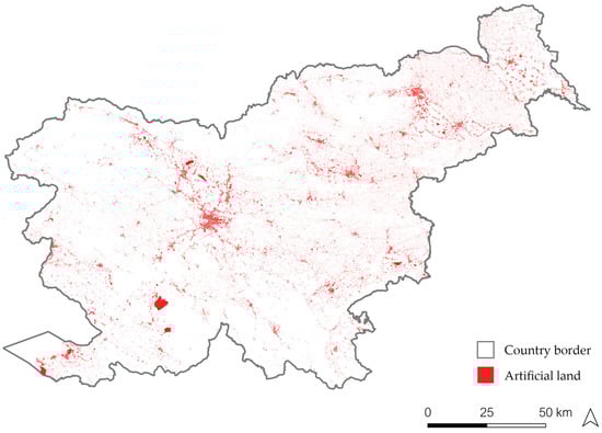
Figure 1.
Artificial land in Slovenia according to data from March 2023 (Source: actual land use of settled land—MNVP; actual land use for public road and railway infrastructure—DRSI).
The red areas in the figure above represent artificial land in Slovenia, as defined by the Spatial Management Act (ZUreP-3) [21], based on data available in March 2023. The total area of artificial land amounts to 115,523 hectares, which corresponds to 5.70% of Slovenia’s territory. Unfortunately, this artificial land layer does not currently support trend analysis, as it is based on a one-time dataset. The layer comprises data from the Registry of Actual Land Use of Settled Land and the Registry of Actual Land Use for Public Road and Railway Infrastructure. The first dataset is still pending formal confirmation and is not yet maintained systematically. The second dataset, which pertains to public road and railway infrastructure, is continuously updated; however, it currently does not include information on associated land for all public municipal roads. Considering these limitations, which are discussed in more detail in Section 2.2, the percentage should be regarded as an estimate rather than an exact figure. Nevertheless, despite these limitations, it provides a representative reflection of the artificial land at the national level.
1.4. Problem Definition and Study Objective
The study addresses two main problems. The first concerns the measures needed to slow the continuous increase in artificialized land. The EU requires Member States to define practices and measures that ensure sustainable soil and land management. The land take hierarchy should be integrated into spatial planning according to the principles of circular space management, considering the order of spatial interventions. First, additional artificialization should be avoided wherever possible. Second, previously artificialized land should be reused. Third, new artificialization should only take place where land is in a less favourable condition. Fourth, mitigation and compensation measures should be applied for any new artificialized land to offset the loss of ecosystem services [6].
Germany, the Belgian regions, France, Luxembourg and Austria are among the five pioneering countries that have been actively engaged in the implementation of the NNLT objective [22]. Slovenia has also taken steps to address this issue by developing the concept of circular spatial management. This concept is based on the principles of the circular economy, adapted and applied to spatial management [20]. While many European countries have already defined the objective of reducing artificializations in their regulations, they often lag behind in designing concrete measures to achieve it [9,17]. To address this gap, the concept of circular spatial management developed in Slovenia also includes practical solutions aimed at reducing and ultimately halting the artificialization of new land [20].
The second problem concerns how to monitor the expansion of artificial land. Statistics on the land take by country are available through international reporting systems based on the Corine Land Cover accounting layer [23]. However, monitoring this expansion process within an individual country in a way that ensures the comparability of results across countries remains a challenge [24]. To enable effective land take monitoring at the EU level, it is essential to standardize terminology across all Member States to ensure consistent definitions of key terms and indicators. Additionally, reliable and harmonized data are essential for accurately monitoring the expansion of artificial land.
Marquard et al. [24] identified a lack of harmonized terminology in the EU and noted that previous studies had already emphasized the need for a clear conceptualization of the terms land consumption and land take [25,26,27], as well as for compatible monitoring and reporting, which affect the credibility of quantitative targets [25,28]. Based on the extensive research already conducted on this problem, the present article does not propose new solutions to that challenge. Instead, it presents methodology for conducting a land take analysis, complemented by a qualitative assessment in two test areas. The results provide insights into newly artificialized land and its driving forces.
2. Materials and Methods
The following section presents the study areas, data availability, data sources and methodology.
2.1. Location of the Study Areas
The study focuses on the Municipality of Maribor and the Municipality of Kungota. The study area was defined through a three-step process, transitioning from a broader scale to specific locations for detailed analysis, as illustrated in Figure 2.
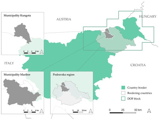
Figure 2.
Study area—The Municipality of Maribor and the Municipality of Kungota in the Podravska region (Slovenia).
The two final study areas were determined through three steps:
- The first step involved selecting an area based on the division of Slovenia into blocks covered by aerial imagery captured in the same year. A block from the northwest part of Slovenia was chosen, as it is covered by digital orthophoto imagery (DOF) for both 2019 and 2022.
- In the second step, the selected block was further refined using administrative boundaries. Within this block, the Podravska region was identified as the most suitable for analysis due to its diverse landscape, which includes both urban and rural characteristics.
- Since the entire Podravska region was too large for a detailed analysis, the third step involved selecting two study municipalities with distinct characteristics:
- a.
- Maribor, an urban municipality, representing a complex artificial environment with diverse spatial development patterns;
- b.
- Kungota, a rural municipality, allowing for the analysis of artificialization in rural environment.
The two study areas serve to validate the methodology for identifying newly artificialized land in diverse environments, as presented in Section 2.3.
2.2. The Problems of Data Availability
The data that can be used to assess land take in Slovenia are currently the data on the actual land use of agricultural and forest land, managed and maintained by the Ministry of Agriculture, Forestry and Food (MKGP). The vector layer is based on the manual identification and interpretation of aerial photographs (DOF) for the relevant time period, approximately every 3 years for each part of Slovenia, and represents the only dataset in Slovenia that provides a continuous time series from which land use trends can be determined. Although the data are primary intended for the implementation of agricultural policy and not for monitoring the expansion of artificial land, the vector layer also contains polygons representing artificial land, which are used to calculate the land take indicator [29]. Due to its primary purpose, the data more closely reflect land cover than actual land function. Nevertheless, it remains the only nationwide dataset with a multi-year time series suitable for tracking land use dynamics throughout the years. As a result, estimates of artificial land expansion based on this dataset are indicative rather than precise. However, with detailed data processing (such as that conducted for the municipalities of Maribor and Kungota) reliable insights into the expansion of artificial land can still be obtained.
In Slovenia, a new register of building land is currently being established, marking an important step toward the official monitoring of land take. The register includes data on artificial land in accordance with the definition in the Spatial Management Act (ZUreP-3) [21]. These data are compiled from two sources: the Registry of Actual Land Use of Settled Land (established by the Ministry of Natural Resources and Spatial Planning—MNVP) and the Registry of Actual Land Use for Public Road and Railway Infrastructure (established by the Slovenian Infrastructure Agency—DRSI). This information is intended to enable accurate monitoring of the expansion of artificial land in relation to the detailed land use.
The register of building land will be developed in several phases. Currently, the first phase—the mass capture on settled land covering the period 2017–2021—has already been completed and this data are already publicly available. However, the dataset is not yet maintained systematically, so comparisons between years are not possible. As on settled land also remain subject to confirmation by the municipalities and landowners. The MNVP is providing municipalities with financial and technical assistance to set up the register by the end of 2026 [30].
At the time of the analysis presented in this paper, the data on public road and railway infrastructure did not yet include data on the associated land of all public municipal roads. As of March 2023—the reference date for the artificial land data presented in this article at the national level—data were still missing for 46 of Slovenia’s 212 municipalities.
2.3. Data Sources
The analysis of the land take status was conducted using open spatial data, as presented in Table 1. The primary data source for the analysis is the actual land use layer of agricultural and forest land from the Ministry of Agriculture, Forestry and Food (MKGP). In addition to this, several auxiliary data sources were utilized, including the actual land use of settled land layer (MNVP), the actual use of building parts from the real estate cadastre (e.g., apartments, offices) (GURS), the land use layer of public road and railway infrastructure (DRSI), roads and railways from consolidated cadastre of economic public infrastructure (GURS), and digital orthophoto imagery (GURS).

Table 1.
Data sources.
2.4. Data Processing and Methods
The data processing consisted of two components: land take monitoring and identification of land take drivers. Both were carried out using the Geographic Information System (GIS) methods in QGIS version 3.34.13. Land take monitoring was conducted to extract newly artificialized land within two study areas. The actual land use layers from the MKGP were initially clipped to the Podravska region. Then, the selection tool was used to extract artificial land for the years 2019 and 2022. In continuation, the intersection tool was used to overlay artificial land layers for the years 2019 and 2022. This overlay allowed for the creation of a difference layer, which identifies land take (newly artificialized land) within the observed period (2019–2022).
The analysis of overlay results revealed that some polygons do not represent newly artificialized land but are instead a result of the following:
- Interpreter inconsistency in two consecutive captures;
- Misclassification of actual use.
In both cases mentioned above, the inappropriate polygons are the result of human error. Based on these findings, the GIS procedure for land take monitoring was defined as presented by a flowchart in Figure 3.
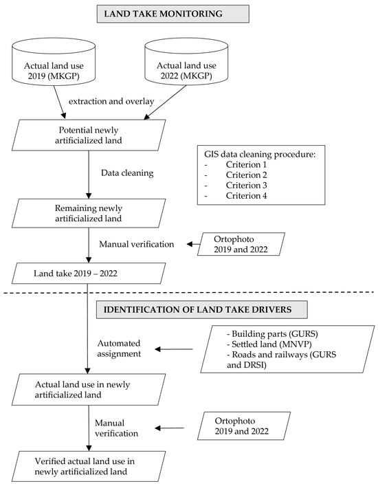
Figure 3.
Flowchart of the proposed procedure.
The process continued with the identification of land take drivers following the land take monitoring. This identification was based on the following data: building parts (GURS), settled land (MNVP), and roads and railways (GURS and DRSI). Using these data, areas identified as newly artificialized were assigned detailed actual land use, which also helped to indicate the underlying drivers of land take.
The land take results for both test areas (with partial results also for the entire Podravska region) are presented in hectares and number of polygons in Section 3.1. Comparing the surface area in hectares with the number of polygons allows for an assessment of how much area was excluded from the land take dataset—either through the GIS-based data cleaning procedure or manual verification. Since land take expressed in hectares does not allow for a meaningful comparison of annual land take rates across spatial units of different sizes, an aspect particularly relevant in this study, land take is additionally presented in m2/year·km2 in Section 4.
The following two subsections provide a detailed description of the individual steps of the proposed procedure.
2.4.1. GIS Procedure for Data Cleaning
The first step after extraction of potential newly artificialized land was data cleaning based on four criteria, which determined the polygons to be excluded:
- Criterion 1: Polygon area smaller than 25 m2.
- Criterion 2: Polygons with a P/A ratio greater than 1.5.
- Criterion 3: Polygon width smaller than 3 m.
- Criterion 4: Sharp polygons with a circle to polygon area ratio greater than 3.
Each of the four criteria is described in more detail below.
- Removal of polygons smaller than 25 m2
To ensure the accuracy of the analysis and reduce the impact of small, irrelevant polygons that could lead to the incorrect interpretations of results, a filtering process was applied to the dataset based on polygon surface area. According to the specifications of the MKGP dataset, a minimum artificial land area of 25 m2 was defined. Any polygons with an area below this threshold were excluded from further analysis.
As a result, the final dataset contained only polygons meeting or exceeding the 25 m2 threshold, allowing for a more relevant analysis of artificial land while minimizing the impact of potential inaccuracies in the original dataset.
- Removal of “slivers” based on perimeter-to-area ratio (P/A)
To further refine the dataset, a method for removing polygons based on the ratio between perimeter and area was applied. The objective of this method was to identify and eliminate elongated and narrow polygons that did not correspond to actual artificial land. The ratio was determined using the following formula: ratio = perimeter/area.
The obtained values were analyzed to identify significant deviations from expected ratios for real artificial land. The threshold for polygon removal was set at a ratio of 1.5, as this was the point where irregular polygons started to emerge while still preserving relevant polygons for further analysis. Through this process, elongated and irregular polygons, likely resulting from data inconsistencies or land use capture errors, were removed, thereby improving the overall quality of the final dataset.
- Removal of “slivers” based on polygon width.
This automated method calculates internal points within polygons that allow for the measurement of polygon width. To remove polygons that do not meet the criteria for actual artificial land, a standard minimum width had to be established, ensuring that the threshold was too narrow to represent road surfaces. Based on the analysis, this threshold was set at 3 m.
The final selection of polygons for removal was based on attribute values; all polygons where the total width was less than 3 m were eliminated from the dataset. By applying this method, elongated and narrow polygons, most likely resulting from data capture errors or misinterpretations of land use, were effectively removed, improving the dataset’s overall accuracy and reliability.
- Removal of polygons with sharp edges.
This automated method identifies polygons with sharp or elongated shapes, which often result from data capture errors or incorrect land use classification. The approach is based on calculating the ratio between the area of the minimum enclosing circle and the polygon’s actual area.
The ratio between the circle’s area and the polygon’s area was computed using the following formula:
Ratio = circle area/polygon area
Polygons with exceptionally high ratio values (greater than 3) were removed, as they indicate that the circle’s area is significantly larger than the polygon’s area. This suggests the presence of highly elongated or sharp-edged shapes, which do not meet the criteria for real artificial land and are likely data anomalies.
However, after the cleaning up the polygons, a quick review of the remaining polygons was conducted. It was found that a significant number of polygons still exhibited unusual shapes. Consequently, the polygons retained according to four criteria were manually reviewed and cleaned. The result was a cleaned set of polygons representing land take over a three-year period (2019–2022). Detailed actual land use was then attributed to the land take polygons to identify which activities are the largest consumers of natural and semi-natural land.
2.4.2. Manual Verification and Assignment of Land Use for Newly Artificialized Land
Manual verification was carried out twice, as shown in Figure 3. The first time, it was performed after the extraction of newly artificialized land from the input data and the GIS data cleaning procedure using four criteria. The second manual verification took place after the automated assignment. The first manual verification checked the accuracy of identifying newly artificialized land, while the second focused on verifying the accuracy of assigning actual land use to these newly artificialized land. In both manual verifications, orthophotos for the observed period were used as the reference layer.
Manual verification in both parts of the procedure—land take monitoring and identification of land take drivers—as well as the assignment itself, was conducted only for the Municipality of Maribor and the Municipality of Kungota, excluding the broader Podravska Region. These smaller study areas allowed for a manual verification and an in-depth examination of borderline cases.
The following is a description of the part of the procedure in which the assignment of actual land use was carried out. The assignment of detailed actual land use for newly artificialized land (2019–2022) on two study areas was conducted using an automated method.
Automated Assignment Method:
- If a polygon contains data on the actual use of building parts from the Real Estate Cadastre (GURS), the land use is assigned based on this data, as it reflects the most up-to-date situation.
- If the polygon lacks real estate cadastre data but is either fully or partially covered by a settled land polygon (MNVP), or lies within 2.5 m of one, land use is assigned based on settled land data. In such cases, polygons assigned land use based on proximity are subject to manual verification.
- If the polygon lacks data from the real estate cadastre (GURS) and settled land (MNVP), but overlaps with data on actual land use for public road and railway infrastructure (DRSI) and/or roads and railways from consolidated cadastre of economic public infrastructure (GURS), the land use is assigned as road and parking areas.
Additional manual verification of the accuracy of the assigned actual land use was conducted for the following groups of polygons:
- Large surface polygons;
- Polygons assigned land use based on proximity to settled land polygon (MNVP);
- Polygons assigned land use based on public road and railway infrastructure (DRSI).
3. Results
As a result of the methodology presented in the previous chapter, land take data was obtained for both study areas and partial land take data for the Podravska Region (Section 3.1). The second output, which is the result of a subsequent process, is the data on actual land use, reflecting the reduction in the amount of (semi-)natural land (Section 3.2).
3.1. Land Take in the Study Areas
Table 2 shows the land take in hectares and the number of polygons. Both values are also presented as a percentage of potential land take. First, the potential land take is shown (Row 3 in Table 2). The entire Podravska Region was not included in the further analysis. This is followed by the remaining land take (Row 5 in Table 2) and the final land take (Row 7 in Table 2). Rows 4 and 6 represent the intermediate reduction in land take during the GIS data cleaning procedure and manual verification.
Table 2.
Land take (2019–2022) based on GIS procedure for data cleaning and manual verification (Podravska Region, Municipality of Maribor and Municipality of Kungota).
Table 2 shows a decrease in the number of polygons that were cleaned using the four criteria mentioned in Section 2.4.1. The four criteria cleaned up the majority of the inappropriate polygons. A total of 76.5% of all input polygons were excluded in the Municipality of Maribor and 64.2% in the Municipality of Kungota. If instead of polygons, the area in hectares is considered, the percentage decreases to (6.0%) or (4.6%), which means that polygons with very small areas were removed. After the GIS data cleaning procedure, 49.49 ha remained in the case of Maribor and 16.45 ha in the case of Kungota, which were reduced by manual verification to the final land take of 39.03 ha and 10.75 ha, respectively. These final land take results correspond to the newly artificialized land developed between 2019 and 2022 and are shown in red in Figure 4. Previously artificialized land (up to 2019) is shown in grey.
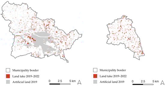
Figure 4.
Land take between 2019 and 2022 in the Municipality of Maribor (left) and the Municipality of Kungota (right).
Aside from the main town of both municipalities (Maribor and Kungota), as well as some other villages with compact artificial land (larger grey areas in Figure 4), Figure 4 illustrates a high dispersion of artificial land by 2019 (shown in grey). The red areas indicate the continuation of this artificialization trend between 2019 and 2022. A detailed land use change analysis for this newly artificialized land is presented in the next chapter. It is important to note that many small polygons (depicted as red dots in Figure 4) are outlined with a bold border on the map for better visibility. Their natural size is relatively small and usually corresponds to small building plots.
Both study areas are relatively small, with areas of 148 km2 (Maribor) and 49 km2 (Kungota). Therefore, land take data in m2/year·km2 are also presented in the discussion section, to provide a clear understanding of the natural and seminatural areas transformed into artificial areas during the studied period.
3.2. Land Use Change Analysis
The land use change analysis was carried out on the cleaned polygons for both study areas (Municipality Kungota and Municipality Maribor), which were assigned an attribute of detailed actual land use, as explained in Section 2.4.2.
The largest share of newly artificialized land between 2019 and 2022 in both study areas corresponds to residential areas, accounting for 60.8% in Maribor and 50.2% in Kungota (Figure 5). In Maribor, a substantial share (20.4%) of land take is attributed to road infrastructure. Agricultural infrastructure represents 6.4%, industry 4.6%, and sport and recreation 3.1% of land take. The presence of other land use appears in smaller proportions. In Kungota, a significant share (23%) corresponds to the expansion of agricultural infrastructure, often associated with the development of supplementary tourism and hospitality activities. Roads represent 9.7%, sport and recreation 9.4%, and tourism and hospitality 7.4% of land take.
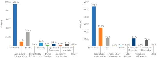
Figure 5.
Land take drivers (%) in the Municipality of Maribor (left) and Kungota (right)—2019–2022.
On the basis of a land take map (Figure 4) and the results of the additional land use change analysis (Figure 5), it can be confirmed that the majority of new land take occurs as an expansion of existing residential areas, while a smaller part represents the expansion of land take in the form of dispersed construction. This is probably a consequence of the fact that development in Slovenia is already fundamentally highly fragmented with large number of small settlements [31].
4. Discussion
The following discussion interprets the key findings of the study and places them in a broader context. As announced in Section 3.1, land take data expressed in m2/year·km2 are also presented in this section (Table 3). The last two rows (Rows 6 and 7) in Table 3 contain land take data for both study areas, derived from our own research (labelled as “original research” in Table 3) and recalculated into m2/year·km2. Row 5, by contrast, presents land take for the entire territory of Slovenia, based on external sources. It should be noted that comparing land take between the two study areas and Slovenia—although all values are expressed in m2/year·km2—is not entirely meaningful, as the results are based on different input data and methodologies.
Table 3.
Land take in Slovenia determined using CLC data and national data (MKGP) for selected time periods (external sources), and land take data for the Municipality of Maribor and the Municipality of Kungota determined using national data (MKGP) for the period 2019–2022 (obtained through the present study).
The land take estimates for the whole of Slovenia in Table 3 were obtained from studies conducted by other authors [1,20,29]. These data are shown once based on Corine Land Cover (CLC) dataset [1] and again based on national data provided by the Ministry of Agriculture, Forestry and Food (MKGP) [20,29]. Land take for the entire country, based on national MKGP data, is presented for two time periods: from 2012–2019, with a value of 279.50 m2/year·km2 [29], and 2015–2022, with a value of 310.79 m2/year·km2 [20]. These values provided by national data provide some evidence that between the two periods considered, there was an acceleration in the consumption of natural and semi-natural land. However, due to the partial overlap between the periods considered, minor methodological changes, and especially the continuously improving quality of input data used by the MKGP for determining actual land use, the trend of increasing land take cannot be fully confirmed based on a comparison of these two periods, nor was this the objective of the present study. Additionally, land take for the entire territory of Slovenia based on CLC is presented [1] and shows that this data source does not allow for accurate identification of newly artificialized land, as the result is significantly underestimated.
The same national MKGP data as for the whole of Slovenia were also used to determine land take in both study areas for the time period 2019–2022. A comparison of land take between the two study areas and the national average shows that land take at the national level is significantly lower than in either study area. This lower value at the national scale is primarily due to the extensive mountainous regions in the north and northwest of Slovenia, as well as the large forested areas in the south—regions that are among the least densely populated in the country. In contrast, neither of the two study areas contains large expanses of very sparsely populated land. On the contrary, according to data from the Statistical Office of the Republic of Slovenia (SURS), the Municipality of Maribor is the second most densely populated municipality in the country, while the Municipality of Kungota ranked 81st out of 212 municipalities in 2022 [32]. Despite the large difference in population density between the two municipalities (766.2 inhabitants/km2 in Maribor and 100.4 inhabitants/km2 in Kungota in 2022) [32], land take values are relatively comparable. This is largely due to the prevalence of multi-apartment residential construction in the Municipality of Maribor (particularly in the city of Maribor) on the one hand, and the predominance of single-family housing in the Municipality of Kungota on the other. According to the results of this study, land take amounted to 881.96 m2/year km2 in the Municipality of Maribor and 731.31 m2/year km2 in the Municipality of Kungota.
Given that the analysis of land take drivers showed that the majority of newly artificialized land stemmed from residential development, the elevated levels of land take observed in both study areas can largely be explained by the concurrent increase in settlement density. According to official data from the Statistical Office of the Republic of Slovenia, population density between 2019 and 2022 increased by 6.3 inhabitants/km2 in the Municipality of Maribor and by 4.4 inhabitants/km2 in the Municipality of Kungota [32]. This observation raises an important policy question: to what extent can the demand for new residential development be met within existing urban areas? While not all needs can be satisfied in this manner, a significant portion of housing demand could plausibly be addressed through the densification and revitalization of already urbanized areas. Realizing this potential, however, requires the systematic implementation of measures outlined in the Strategic Plan for Circular Spatial Management 2024–2030 [20], as discussed in Section 1.3 of this study. Among the plan’s priority actions are two key interventions: (1) the renovation of buildings and public spaces in urban centres, aimed at reversing the ongoing depopulation of inner-city areas, and (2) the development of public rental housing in line with the principles of circular land management. The latter is particularly relevant in the case of Maribor (as second largest city of Slovenia [33], a centre of international importance and an important scientific and educational (a university), healthcare (university medical centre), cultural (national theatre, museums), judicial, sports and employment centre of the eastern part of the country, and one of the priority areas for housing development according to the Spatial Development Strategy of Slovenia 2050 [34]), where housing demand continues to significantly exceed available supply [33].
5. Conclusions
The trend shows that the amount of artificial land in Slovenia (and more broadly across Europe) continues to grow. Effectively addressing this issue requires both reliable monitoring using appropriate indicators and the development of targeted measures that support a transition toward more sustainable, circular and spatially efficient land management. The present article presents a precise methodology for accurately determining land take using national-level input data. The targeted measures aimed at reducing the annual increase in artificial land are briefly presented in Section 1.3.
The problem of artificialization, monitored through the land take indicator, remains one of the key spatial and environmental challenges in contemporary spatial planning. The study highlighted the discrepancy between land take estimates derived from different data sources and methods, which hinders the reliable monitoring of the process and the comparability of land take across countries. While CLC data at the European level are less precise, their value lies primarily in enabling the observation of broader land use trends across Europe. In the case of Slovenia, the land take indicator derived from CLC data measures 52.78 m2/year·km2 for the period 2012–2018, while the indicator based on national data reports a significantly higher value of 279.50 m2/year·km2 for the period 2012–2019. However, national indicator values are not always directly comparable across countries. Key differences arise from differences in input data types and their accuracy, and differences in data processing methods.
To reliably monitor the growth of artificial land at the national level and to meet future EU requirements, ensuring the comparability of land take indicators across countries is essential. The annexes to the proposed Soil Monitoring Law state that the methodologies chosen for assessing land take shall be either available in scientific literature or publicly accessible [8]. In this context, the land take methodology presented for the two case study areas demonstrates an approach to identifying land take under conditions where a dedicated and systematically maintained layer of artificial land is not yet established. Although the methodology provides solutions adapted to the current availability and quality of input data in Slovenia, it could (with appropriate modifications) also prove applicable in other countries or regions. It should be noted, however, that the effectiveness of the proposed methodology largely relies on manual verification, which is time-consuming and limits its scalability to larger areas. For this reason, enhancing the methodology through increased automation would be a meaningful step toward improving its practical applicability. An advantage of the methodology is the inclusion of a qualitative assessment of actual land use on newly articulated land to identify the drivers of land take. The data obtained from this analysis can support data-driven decision—making by policymakers in implementing the NNLT policy.
Achieving reliable results also depends on the availability of high-quality input data, specifically designed for monitoring the land take indicator. As highlighted in Section 2.2, this study also revealed issuesrelated to data availability. The analysiswas conducted using data from the Ministry of Agriculture, Forestry and Food (MKGP), which collects information on the actual land use of agricultural and forest land, including data on artificial land. However, these data were not originally intended for land take monitoring. To address this limitation, additional sources (such as data on building parts, settled land, roads and railways) were integrated to identify the land use of newly artificialized land. This highlightsthe need for establishing a dedicated register of building land. Such data would enable accurate monitoring of the expansion of artificial land in relation to detailed land use. However, in order to serve its intended purpose of representing key information for tracking land take trends, the register of building land must include comprehensive information on all artificial land and be systematically maintained.
Assuming that national land take increased between the two analyzed periods (although this cannot be confirmed with certainty due to differences in input data and methodologies), we propose the following recommendations, which are also set out in the EU Soil Strategy for 2030. These include limiting land take through circular land use, establishing effective land monitoring, and continuing both new research and innovation efforts as well as public engagement [6].
The latter is of particular importance in the Slovenian context, which is characterized by mostly historically conditioned dispersed settlement patterns. Such patterns are unsustainable, as they contribute to the increased consumption of natural and seminatural land, and promote land take. For these reasons, it is crucial to prioritise the internal development of settlements and the renewal of functionally degraded sites prior to initiating new spatial interventions on undeveloped land [21]. In addition, raising public awareness about the long-term negative impacts of dispersed settlement and encouraging more sustainable spatial development practices are essential.
Author Contributions
Conceptualization, P.L., K.K., B.Č., T.Č. and I.L.; methodology, B.Č. and T.Č.; software, K.K.; validation, P.L. and I.L.; writing—original draft preparation, P.L.; writing—review and editing, P.L., K.K., B.Č., T.Č. and I.L.; visualization, K.K.; project administration, B.Č. All authors have read and agreed to the published version of the manuscript.
Funding
This research was funded by Support for the implementation of circular spatial management principles funded by the Ministry of Natural Resources and Spatial Planning (Contract Nos.: 2560-24-57001, 2560-25-57002 and 2560-25-510027).
Data Availability Statement
The data are available on request from the corresponding author.
Conflicts of Interest
The authors declare no conflicts of interest.
Abbreviations
The following abbreviations are used in this manuscript:
| CLC | Corine Land Cover |
| DRSI | Slovenian Infrastructure Agency |
| DOF | Digital Orthophoto |
| EU | European Union |
| GIS | Geographic Information System |
| GURS | Surveying and Mapping Authority of the Republic of Slovenia |
| MKGP | Ministry of Agriculture, Forestry and Food |
| MNVP | Ministry of Natural Resources and Spatial Planning |
| NNLT | No Net Land Take |
References
- European Environment Agency (EEA). Land Take and Net Land Take. Analysis and Data. Available online: https://www.eea.europa.eu/en/analysis/maps-and-charts/land-take-statistics-dashboards (accessed on 31 March 2025).
- Steffen, W.; Richardson, K.; Rockström, J.; Cornell, S.E.; Fetzer, I.; Bennett, E.M.; Biggs, R.; Carpenter, S.R.; de Vries, W.; de Witt, C.A.; et al. Planetary boundaries: Guiding human development on a changing planet. Science 2015, 347, 6223. [Google Scholar] [CrossRef] [PubMed]
- Korhonen, J.; Honkasalo, A.; Seppälä, J. Circular Economy: The Concept and its Limitations. Ecol. Econ. 2018, 143, 37–46. [Google Scholar] [CrossRef]
- European Commission (2011): Communication from the Commission to the European Parliament, the Council, the European Economic and Social Committee and the Committee of the Regions: Roadmap to a Resource Efficient Europe. Available online: https://eur-lex.europa.eu/legal-content/EN/ALL/?uri=CELEX%3A52011DC0571 (accessed on 31 March 2025).
- The Seventh Environment Action Programme of the European Union Until 2020 (Official Journal of the European Union, L 354/171, 2013). Available online: https://eur-lex.europa.eu/legal-content/EN/TXT/PDF/?uri=CELEX:32013D1386 (accessed on 2 April 2025).
- European Commission (2021): Communication from the Commission to the European Parliament, the Council, the European Economic and Social Committee and the Committee of the Regions: The EU Soil Strategy for 2030. Reaping the Benefits of Healthy Soil for People, Food, Nature and Climate. Available online: https://eur-lex.europa.eu/legal-content/EN/TXT/?uri=CELEX%3A52021DC0699 (accessed on 31 March 2025).
- The Eighth Environment Action Programme of the European Union Until 2030 (Official Journal of the European Union, L 114/22, 2022). Available online: https://eur-lex.europa.eu/legal-content/EN/TXT/HTML/?uri=CELEX:32022D0591 (accessed on 2 April 2025).
- European Commission (2023): Proposal for a Directive of the European Parliament and of the Council on Soil Monitoring and Resilience (Soil Monitoring Law). Available online: https://eur-lex.europa.eu/legal-content/EN/TXT/?uri=celex%3A52023PC0416 (accessed on 3 April 2025).
- Gensheimer, M.; Rossignol, M.; van Herwijnen, M.; Desjardins, X.; Devos, T.; Leclercq, A. Policy Brief. No Net Land Take Trajectories. Policies and Practices Across Europe; ESPON EGTS: Luxembourg, 2024; p. 20. Available online: https://www.espon.eu/sites/default/files/2024-12/no-net-land-take-trajectories_policy-brief.pdf (accessed on 12 March 2025).
- The Alpine Convention. Land Take in the Alpine Region: The Data Perspective. Summary. Available online: https://www.alpconv.org/fileadmin/user_upload/Organisation/TWB/SPSD/CDR_ACTS_IP_S3_1a_Land_Take_Data_Summary.pdf (accessed on 12 March 2025).
- Fina, S.; Hamacher, H.; Rönsch, J.; Scholz, B. Land Use Monitoring and Land Take in International Comparison: Methods and Data. Final Report; Umweltbundesamt: Dessau-Roßlau, Germany, 2023; p. 52. Available online: https://www.umweltbundesamt.de/en/publikationen/land-use-monitoring-land-take-in-international (accessed on 12 March 2025).
- LCplus Backbone 2021 (Raster 10 m), Europe, 3-Yearly. Available online: https://land.copernicus.eu/en/products/clc-backbone/clc-backbone-2021 (accessed on 20 May 2025).
- LCplus Backbone 2021 (Raster 10 m), Europe, 3-Yearly. Product User Manual. Available online: https://land.copernicus.eu/en/technical-library/product-user-manual-clc-backbone-2021/@@download/file (accessed on 20 May 2025).
- European Environmnet Agency: Net Land Take in Cities and Commuting Zones in Europe. Available online: https://www.eea.europa.eu/en/analysis/indicators/net-land-take-in-cities (accessed on 12 March 2025).
- Urban Atlas. Available online: https://www.eea.europa.eu/en/datahub/datahubitem-view/e006507d-15c8-49e6-959c-53b61facd873 (accessed on 12 March 2025).
- Urban Atlas. Available online: https://land.copernicus.eu/en/products/urban-atlas (accessed on 20 May 2025).
- D’Ascanio, R.; Desjardins, T.X.; Devos, T.; Dupont, V.; Estèbe, P.; Leclercq, A.; Palazzo, A.L.; Roose, T.A.; Sadowy, K.; Siedentop, S.; et al. No Net Land Take—Policies and Practices in European Regions. Main Administrative, Economic, Political or Social Challenger to Implement No Net Land Take (NNLT). Final Report; ESPON EGTC: Luxembourg, 2024; p. 88. Available online: https://www.espon.eu/sites/default/files/2024-06/no-net-land-take-policies-and-practices-in-european-regions-final-report.pdf (accessed on 12 March 2025).
- The Alpine Convention. Land Saving Targets in Alpine Countries: Status Quo and Challenges. Available online: https://www.alpconv.org/fileadmin/user_upload/Organisation/TWB/SPSD/CDR_ACTS_IP_SP1_3_Land_Saving_Targets.pdf (accessed on 12 March 2025).
- Environment Agency Austria. Umweltbundesamt. Flächenanspruchname. Available online: https://www.umweltbundesamt.at/umweltthemen/boden/flaecheninanspruchnahme/datengrundlage/fragen-und-antworten-zur-neuen-methodik (accessed on 12 March 2025).
- Portal GEO Slovenija. Sotočje Prostorskih Informacij. EUKN Policy Lab—Krožno Gospodarjenje S Prostorom—GRADIVO. Available online: https://www.geo-slovenija.si/blog/eukn-policy-lab-krozno-gospodarjenje-s-prostorom-gradivo (accessed on 12 March 2025).
- Spatial Management Act. Zakon O Urejanju Prostora (ZUreP-3). Available online: https://pisrs.si/pregledPredpisa?id=ZAKO8249 (accessed on 6 April 2025).
- Lacoere, P.; Decoville, A.; Delattre, R.; Melot, R.; Grimski, D.; Schamann, M.; Halleux, J.-M. National introduction of no net land take: A comparative study of five pioneering countries seeking to limit their land consumption. Town Plan. Rev. 2024, 96, 4. [Google Scholar] [CrossRef]
- European Environment Agency (EEA). Corine Land Cover Accounting Layer. Available online: https://www.eea.europa.eu/en/datahub/datahubitem-view/a55d9224-a326-4cb1-9b9c-3a324520341a (accessed on 7 April 2025).
- Marquard, E.; Bartke, S.; Gifreu i Font, J.; Humer, A.; Jonkman, A.; Jürgenson, E.; Marot, N.; Poelmans, L.; Repe, B.; Rybski, R.; et al. Land consumption and land take: Enhancing conceptual clarity for evaluating spatial governance in the EU context. Sustainability 2020, 12, 8269. [Google Scholar] [CrossRef]
- Decoville, A.; Schneider, M. Can the 2050 zero land take objective of the EU be reliably monitored? A comparative study. J. Land Use Sci. 2016, 11, 331–349. [Google Scholar] [CrossRef]
- Desrousseaux, M.; Schmitt, B.; Billet, P.; Béchet, B.; Le Bissonnais, Y.; Ruas, A. Artificialised land and land take: What policies will limit its expansion and/or reduce its impacts? In International Yearbook of Soil Law and Policy 2018, 1st ed.; Ginzky, H., Dooley, E., Heuser, I.L., Kasimbazi, E., Markus, T., Qin, T., Eds.; Springer Nature: Cham, Switzerland, 2019; pp. 149–165. [Google Scholar]
- Nicolau, R.; David, J.; Caetano, M.; Pereira, J.M.C. Ratio of Land Consumption Rate to Population Growth Rate-Analysis of Dierent Formulations Applied to Mainland Portugal. ISPRS Int. J. Geo-Inf. 2019, 8, 10. [Google Scholar] [CrossRef]
- BIO by Deloitte. Study Supporting Potential Land and Soil Targets Under the 2015 Land Communication; Report Prepared for the European Commission, DG Environment in Collaboration with AMEC, IVM and WU; Publications Office of the European Union: Luxembourg, 2014; p. 464. [Google Scholar]
- Slovenian Environment Agency. Environmental Indicators in Slovenia. Land Take. Soil and Land Take. Land Take. Available online: https://kazalci.arso.gov.si/en/content/land-take-0 (accessed on 6 April 2025).
- Spatial Information System of Republic of Slovenia. The Register of a Building Land. Available online: https://pis.eprostor.gov.si/en/pis/evidenca-stavbnih-zemljisc.html?changeLang=true (accessed on 6 April 2025).
- Bizjak, I.; Cotič, B.; Gantar, D.; Gulič, A.; Koblar, S.; Kozamernik, J.; Mušič, B.; Mujkić, S.; Nikšič, M.; Sendi, R.; et al. Poročilo o prostorskem razvoju 2021 [Spatial Development Report 2021]; Ministrstvo za okolje in prostor, Direktorat za prostor, graditev in stanovanja: Ljubljana, Slovenia, 2021; p. 117. Available online: https://www.gov.si/assets/ministrstva/MNVP/Dokumenti/Prostorski-razvoj/porocilo_prostorski_razvoj_2021.pdf (accessed on 6 April 2025).
- Statistical Office of the Republic of Slovenia. SISTAT Database. Available online: https://pxweb.stat.si/SiStat/en (accessed on 6 June 2025).
- Surveying and Mapping Authority of the Republic of Slovenia. Report on the Slovenian Real Estate Market for the Year 2022. March 2023. Available online: https://www.e-prostor.gov.si/podrocja/trg-in-vrednosti-nepremicnin/trg-nepremicnin/?acitem=1967-2268 (accessed on 5 June 2025).
- Bartol, B.; Humerca Šolar, L.; Lupše, I.; Miklavčič, T.; Torbica, J. Spatial Development Strategy of Slovenia 2050; Ministry of Natural Resources and Spatial Planning: Ljubljana, Slovenia, 2024; p. 99. Available online: https://www.gov.si/assets/ministrstva/MNVP/Dokumenti/Prostorski-razvoj/SPRS/Strategija-prostorskega-razvoja_2050_v-angleskem-jeziku.pdf (accessed on 7 June 2025).
Disclaimer/Publisher’s Note: The statements, opinions and data contained in all publications are solely those of the individual author(s) and contributor(s) and not of MDPI and/or the editor(s). MDPI and/or the editor(s) disclaim responsibility for any injury to people or property resulting from any ideas, methods, instructions or products referred to in the content. |
© 2025 by the authors. Licensee MDPI, Basel, Switzerland. This article is an open access article distributed under the terms and conditions of the Creative Commons Attribution (CC BY) license (https://creativecommons.org/licenses/by/4.0/).