Abstract
With the development of international cultural heritage, the positive shift from historic environments to historic urban landscapes has been explored in China. At the same time, China is also trying to extend its heritage corridors to historic urban landscape corridors; thus, the spatial organization characteristics and themes of historic landscapes are being explored. This study took the Dunhuang Oasis area as an example and, based on regional, cultural, and natural heritage sites and man-made environmental characteristics, identified and evaluated historic urban landscape corridors. The least cumulative resistance model was applied to identify historic landscape corridors, and the multicenter evaluation model was used to classify the historic landscape corridors. From the perspective of corridor identification, the military defense and historic landscapes of the city ruins together reflect the human need for “city administration–border defense–ancient trade and commerce”. Grottoes and scenic landscapes are more dependent on the Gobi Desert, mountains, and other areas intertwined with the oasis. The drainage system and water conservancy landscape consists of four stable landscape corridors containing east, west, north, and south canals, which are the basic driving force for the growth of the town. From the corridor hierarchy, we studied layer formation from the Dunhuang urban area, the western and northern local oasis dry canal, Mingsha Mountain–Crecent Spring, etc., as interconnected trunk corridors. The periphery of the Dunhuang urban area encompasses the southern trunk canal, southeastern Mogao Grottoes–Sanwei Mountain road, and other branch corridors. This study determined the composition and level of importance of historic landscape corridors, while at the same time enhancing the visual representation and skyline organization, which can be used for territorial spatial planning and research in functional urban areas.
1. Introduction
Due to the rapid development of urban construction and construction technology, the demolition or reconstruction of buildings has increased. This leads to a change in the nature of the land in some areas, seriously affecting the preservation of residents’ cultural memories; an example of this is the demolition of the theater in Alexandria, Egypt [1]. Thus, there is a certain degree of difficulty in preserving the architectural heritage of cities with a long history [2]. In China, rapid urbanization in the 21st century has intensified the conflict between urban development and construction activities and the protection of natural and cultural heritage, with most heritage sites remaining in cities currently scattered [3]. In the current urban development era, stock land reuse is the main focus. Stimulated by the pursuit of retaining the esthetics and culture of these heritage sites, urban research has begun to pay close attention to the value, composition, and construction of heritage-related historic landscapes. However, these historic landscapes are generally isolated and lack relevance to other historic landscapes and harmonization with the surrounding built environment. Building urban and historic rural landscape corridors by closely linking the isolated historic landscapes inside the city and the rich cultural and natural heritage landscapes on the city’s periphery is a method to establish the spatial pattern of local cultural heritage.
UNESCO’s Recommendation on the Historic Urban Landscape (HUL), issued in 2011, promotes governance reforms that are more inclusive and holistic in nature, favoring the integrated management of urban environments [4]. Historic urban landscapes include not only monuments and historic environments, but also intangible cultural heritage such as traditional crafts and cultural landscapes. Not only should sustainable urban development be incorporated into heritage conservation, sustainable tourism be highlighted, community participation and ownership be emphasized, and educational programs and monitoring be developed [5], but also the geomorphic characteristics and typology of urban environments should be considered in order to strengthen the effectiveness of urban landscape management and to explore the mechanisms of sustainable landscape planning [6]. The development of historic urban landscapes is not only conducive to retaining local cultural memories and creating a sense of local historical cognition [1], but it also promotes continuous interactions between the daily activities of local residents and the physical space, including the landscape and functional and spiritual dimensions. It also advances the realization of human values, improves residents’ quality of life, and more effectively promotes heritage conservation and landscape shaping [7].
In this context, the conservation and utilization of historic urban landscapes should be based on individual urban areas, and a landscape conservation framework considering the overall area should be systematically constructed. Moreover, the thematic characteristics of cultural space, the social characteristics of spatial behaviors, and the diversity of forms of spatial conservation in the setting of the historic landscape should be explored [8]. Strengthening the construction of historic urban landscape corridors allows people to comprehensively understand the social, economic, and cultural phenomena in different historical periods; moreover, it can generate a systematic understanding of the interactions between historic landscapes and these phenomena.
2. Dynamics of Research on Historic Urban Landscape Patterns and Their Corridors
2.1. From the Conservation of Monuments to the Development of Historic Urban Landscape Forms
Heritage monuments and their historic environment lay the foundation for a city’s historic landscape. In the 1920s, the protection of the environment began to be emphasized in monument conservation to a certain extent, and this period was dominated by the restoration of historic monuments and their environment. In the 1970s, the international protection of the world’s cultural and natural heritage was proposed, and at the same time, environmental elements such as urban culture began to be explored, with new concepts such as historic areas and historic gardens being proposed [9]. Since the 1990s, due to the development of the urban economy and the improvement of residents’ quality of life, the improvement of the urban environment has been highlighted. Around the 21st century, the focus of cultural heritage switched to vernacular architectural heritage, industrial heritage, and intangible cultural heritage, as well as to the spatial carriers of these heritage sites, such as cultural tourism, historic lots, vernacular built environments, and cultural heritage sites. This highlights the multifaceted nature of the environmental composition and landscape shaping and emphasizes the protection and application of the overall value of cultural relics and monuments [10,11,12,13,14].
Policy documents on historic urban landscapes have progressively been expanded. In 2000, the European Union issued “The European Landscape Convention: Conservation, Management, and Planning of Landscape Heritage and Resources”. In the same year, the “Guiding Principles for the Sustainable Spatial Development of the European Continent” made historic landscapes national assets for protection and management. In 2005, the Vienna Conference led to the adoption of the Vienna Memorandum on “World Heritage and Contemporary Architecture—Managing the Historic Urban Landscape” (i.e., the Vienna Memorandum), which introduced the historic urban landscape (HUL) for the first time [15]. The introduction of the historic urban landscape has promoted a landscape approach to urban conservation and also emphasized the urgent need to address the development pressures faced when managing the conservation of historic cities. In the same year, UNESCO adopted the Declaration on the Conservation of Historic Urban Landscapes, stating that “vibrant historic cities, especially world heritage cities, need an urban planning and management policy that takes conservation as its main point of departure”. In 2011, UNESCO adopted the Recommendation on the Historic Urban Landscape (the revised recommendation) [16], which considers urban areas as historic layers with cultural and natural value and unique characteristics and that urban heritage is the result of the dynamic overlap between historic layers and contemporary development, emphasizing the material and spiritual links between culture and nature. In 2012, the UNESCO World Heritage Institute of Training and Research for the Asia and the Pacific Region (Shanghai) organized a seminar on historic urban landscapes to discuss the Chinese roadmap for the implementation of this recommendation, while in 2013, UNESCO published a brochure entitled “Detailed Approaches to the Conservation of Historic Urban Landscapes for the Rejuvenation of Historic Cities”. In contrast to the traditional zoning approach, which divides cities into individual conservation areas and creates “islands” of historic preservation, cultural diversity and creativity in historic urban landscapes are recognized as important assets for human, social, and economic development. The brochure reinforces the concept of “layer” as an extension of “layering”.
In accordance with the Operational Guidelines for the Implementation of the World Heritage Convention, world heritage can be categorized as cultural heritage, natural heritage, mixed cultural and natural heritage, and cultural landscapes. Julian Smith (2010) proposed the concept of historic urban landscapes as cultural landscapes for urban residents [17]. Their study concluded that the historic urban landscape is an overall summary and distillation of these various types of heritage concentrated in a certain geographical area, as well as a collection of urban cultural heritage, natural heritage, mixed cultural and natural heritage, and cultural landscapes and a comprehensive, systematic, and holistic landscape form. The research scope of cultural relics and monuments has been further extended to the historic urban landscape, resulting in a landscape that includes not only the cultural heritage itself, but also a number of regional contexts, landscape compositions, buildings, open spaces, etc., including humanistic, artificial, natural, and ecological environments, with a greater emphasis on the holistic value of the cultural heritage [18] (Figure 1).
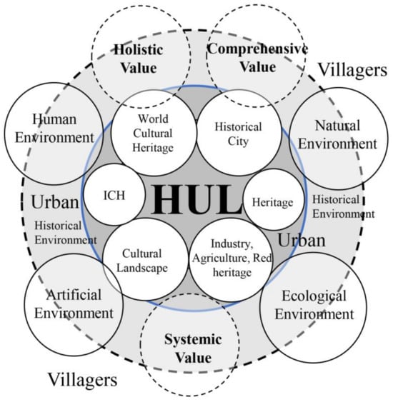
Figure 1.
Compositional patterns of the historic urban landscape.
Against the background of the above development history, Zhang Song emphasized that there should be a positive shift from a historic environment to a historic urban landscape. It is argued that there are some successful demonstrations of the holistic conservation of China’s historic environment or built environment and its heritage, but it still faces many problems and challenges [19]. Because the physical environment of historic cities is constantly changing and extending over time, the concepts, forms, and methods of historic urban landscapes can be applied to include traditional elements of continuous stability or orderly change as historic landscape components [20].
During this period, historic urban landscapes have been widely studied in China. From the introduction of historic urban landscapes to the relationship between historic landscapes and people, nature, and society, to the exploration of historic landscapes as a holistic approach to conservation, since 2013, the emphasis has begun to be placed on the practical and layered construction of historic cities [20]. For example, some scholars have adopted the “landmark–substrate” model and constructed the “anchoring–layering” model to sort out and summarize the spatial and temporal characteristics of the life course [21]. One study concluded that this holistic approach should emphasize authenticity, stability, dynamism, relevance, completeness, and cascading [22]. In the process of sorting, screening, and extracting historic landscape elements, we need to fully consider the basic requirements of authenticity, stability, and dynamism. On this basis, landscape elements that highlight the relevance and completeness are combined into many cultural layers that carry the collective memory of time and space, representing the historical activities and social phenomena of human continuity at different time stages.
Currently, the use of interdisciplinarity is beginning to be emphasized in HUL research, contributing to the development of a historic landscape approach [23]. Through the combination of historic data interpretation and ArcGIS spatial analysis, related research combines cultural and natural features, analyzes the stratification of the historic landscape, and proposes the transformation management strategy of the historic landscape for economic development [24,25].
2.2. From Heritage Corridors to Historic Urban Landscape Corridors
The concept of heritage corridors originated from greenways and heritage area studies that were conducted in the United States in the 20th century. Heritage corridors are composed of greenways, trails, heritage sites, and interpretive systems, where the latter is a synthesis and specific explanation of the first three. In China, reviews of research on heritage corridors [26,27,28] and linear non-heritage corridors [29] have been carried out, and research dimensions and methods have been developed. For example, the three dimensions of conservation technology, organization and management, and spiritual philosophy adopted for the Canal National Heritage Corridor are of great significance for large-scale linear heritage conservation [30]. The minimum cumulative resistance (MCR) model was applied to extract heritage corridors to facilitate the reorganization of linear space, and corridor hierarchy has been measured using a multicentrality assessment (MCA) model [31].
This study draws on research on cultural landscape safety patterns based on the least cumulative resistance model [32], further deepening exploratory research by combining the application of existing studies on heritage corridors and landscape corridors. He Ding (2022) extracted heritage corridors by applying the minimum cumulative resistance (MCR) model to facilitate the reorganization of linear space [31], while Dai Shanlin (2021) studied the construction of historic and cultural landscape corridors in the central city of Fuzhou based on the MCR, enriching the overall spatial protection pattern of historic and cultural neighborhoods [32]. Multicentrality assessment (MCA) models and spatial syntax are mostly applied in the study of urban spatial network patterns [33], and the MCA model has also been applied to match transportation networks with population distributions and disaster-avoidance green spaces [34]. He Ding (2022) also carried out corridor hierarchical measurements through a multicentrality assessment (MCA) model [31]. It can be seen that the MCR and MCA models have good applicability to the study of historic landscape corridors at the planar two-dimensional spatial level.
3. Subject of the Study and Its Methodology
3.1. Research Object
Since the establishment of Dunhuang County in the Han Dynasty, Dunhuang has gradually become the hub of cultural exchanges between the East and the West, and has been called a place where “the Chinese and Xirong cultures converged to create a metropolis”. It is the meeting place of four ancient civilizations, the “key to the throat” of the ancient Silk Road between the Central Plains and the Western Regions, one of the second batch of famous Chinese historic and cultural cities, and has outstanding historic and cultural landscape value [35].
This study focuses on the Dunhuang Oasis area, north of the confluence of the Dang River and the Shule River, south of the Mogao Grottoes protection range, west of the South Lake wind wall sub, and east of the edge of the oasis. Since the Han Dynasty, due to the formation of the military defense system and the postal system and the excavation of the irrigation canal system, the reclamation of cantonment agriculture, the formation of the ancient Silk Road, grotto art, scenic sites, etc. [36,37], the city site has gradually developed. Dunhuang’s cultural heritage, in terms of its typological characteristics, includes key national immovable cultural relics such as the Great Wall, grottoes, and ancient roads, which are announced (recognized) by the province, city, and county, as well as cultural relics for which recommendations for protection have been made in cultural relic surveys [38,39], tangible cultural heritage such as historic cultural cities (including historic cultural districts) (Figure 2), and intangible cultural heritage [40]. China has proposed to build a national cultural park for the Great Wall, and the Han Dynasty Great Wall in Dunhuang is not only a key national cultural relics protection unit, but also a display park for the historic landscape of the “Han Dynasty Seaside of the West River”, which has unique humanistic charms and symbols of the national spirit. The Dunhuang Grottoes, represented by the Mogao Grottoes, are the essence of the culture and art of the Silk Road and have a strong international tourist appeal. Mingsha Mountain has become a famous local natural landscape in Dunhuang since the Tang Dynasty, which has been recorded in “Dunhuang Records”, “Old Book of the Tang Dynasty—Geography”, and “Gao Ju Zi Xing Ji”. The ancient Silk Road, historic districts, traditional villages, and other sites bear the Silk Road’s multicultural interactions and historical memory, which together constitute a valuable Dunhuang historic landscape resource system.
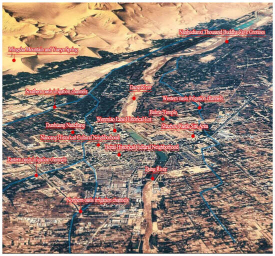
Figure 2.
Spatial annotation of the major historic landscape elements in the Dunhuang urban area (image source: Fuding).
3.2. Data Sources
The data used in this paper mainly include land use data, remote sensing image data, and cultural relics census data. Among these, the land use data, as well as river, canal system, transportation, and road data, were taken from the 2023 land use change survey. The remote sensing image data are high-resolution images of Gansu Province from 2023, and topographic elevation and slope data were taken from a geospatial data cloud (http://www.Gscloud.cn/ on 5 December 2024). The mountain and ancient river records, Dunhuang city passes, and other materials were taken from “Dunhuang Zhi (full)” (Qing Daoguang: eleven years of publication), “Qing Daoguang years: Dunhuang territory general map”, “Qing Daoguang years: the Dang water north flow map”, “Qing Daoguang years: Dunhuang city pass general map”, and written records, while the ancient ditch system data and other materials were taken from “Dunhuang historical geography introduction” (Li Zhengyu), “Du Xiang canal embracing the water for seven miles: a schematic diagram”, “Tang and Song dynasty: Dunhuang Oasis ditch system: a schematic diagram”, “Dunhuang ditch system map of the Qing Dynasty”, and written records. The location, age, category, protection level, and current protection status of cultural relic resources were derived from Jiuquan City’s “One Base Map Data” and Dunhuang City’s Master Plan for the Protection and Utilization of Immovable Cultural Relics. Catering, food, hotel, and accommodation data were taken from the Baidu map, downloaded from the BIGEMAP image platform. Tourist attractions and resource data were taken from the Dunhuang tourism resource survey statistics.
3.3. Research Methodology
3.3.1. Minimum Cumulative Resistance (MCR)
The resistance surface is the resistance of the landscape to extending outward. Different landscape types have different material, energy, and information exchanges due to the differences in the surrounding natural geomorphological features, the composition of the human environment, etc. [41,42]. The minimum cumulative resistance (MCR) model has been introduced to heritage corridor suitability analysis [43] to simulate the movement characteristics of the heritage landscape through certain corridors, paths, or axes. In this study, combined with the method presented by He Ding et al. to construct heritage corridor systems [31,32], the historic landscape corridor in the Dunhuang Oasis region was constructed based on this model, and the specific formula is as follows:
3.3.2. Multicenter Assessment Model (MCA)
Based on the MCA model [31], with the help of the Urban Network Analysis (UNA) tool, we used straightness, intermediation, and proximity to measure the centrality of historic landscape heritage corridors. In this case, straightness is the ratio of the Euclidean distance from a landscape point to all other nodes to the actual geographic straight-line distance (when there are no changes in terrain relief) and is used to measure the extent to which the shortest path between two nodes deviates from the straight-line path. Intermediation is the sum of the proportions of the number of times the shortest paths of any two landscape points pass through a given landscape point and is used as a measure of the value of traffic flow at a network node. Proximity is the inverse of the sum of distances from a landscape point to all other landscape elements within the search radius. It can indicate the combined proximity to the experiencer (Table 1).

Table 1.
Evaluation methods for the centrality of historic urban landscape corridors.
3.4. Layered Delineation of Dunhuang’s Historic Urban Landscape
From cultural heritage and cultural landscape elements to historic urban landscapes, it is necessary to organize and form a hierarchy of the main components of historic landscape elements, as well as their characteristic historic environment elements, from the perspective of cultural heritage protection. The Japanese theory of the “metabolic city” emphasizes the historical process of urban development and change. The elements of life that survive at different stages of history and the process of development need to be continued and regenerated. Under this guidance, taking into account the life course of Dunhuang’s cultural heritage, it can be divided into phases of completion (Han Dynasty–Tang Dynasty), survival (Wei and Jin Dynasties–mid-Ming Dynasty), demise (late Ming Dynasty–Republic of China), and regeneration (since the founding of the nation) according to the sequential order of temporal and spatial evolution. In this way, the importance of extrapolation of the historic landscape at different stages of time is highlighted so as to obtain the various stabilizing elements of the historical stratification.
Because mountains, rivers, the Great Wall, ancient roads, and settlements in the oasis area of the Hexi corridor in China are mostly distributed in strips, the concept of heritage corridors is introduced here, as well as methods to research them, to highlight the linear spatial organization of the corridors in the oasis area by identifying the historic urban landscape corridors. In the study presented in this paper, it was first necessary to emphasize the basic requirements of authenticity, stability, and dynamics and to transform the historical and cultural resources with a certain value, historical authenticity, and stable existence into historic urban landscape elements. Then, landscape elements were combined by considering the aspects of relevance, completeness, and stratification, with the combination of interrelated and mutually integral landscape elements systematically stratifying historic landscape elements. In this process, it is important to reinforce the integrated, systematic, and holistic nature of these historic landscape layers. Using a base map of a cultural heritage space in Jiuquan City, we fully combined the historical maps and archival records from the Tang, Song, and Qing dynasties to construct a basic database of historic landscape elements in this study. Combined with the basic requirements of authenticity, stability, and dynamics, it was constructed according to relevance and completeness so as to form four layers of the historic landscape, namely military defense, city ruins, grottoes and scenic sites, and canal systems and water conservancy (Figure 3) (Table 2).
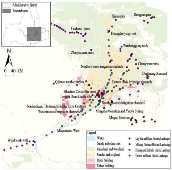
Figure 3.
Location of Dunhuang Oasis and distribution of historic landscapes in the study area.
Table 2.
Layered composition of historic landscape elements in the Dunhuang Oasis area.
4. Identification of Historic Landscape Corridors Based on MCR Modeling
4.1. Resistance Factor Selection and Weight Determination
Taking the 194 historic landscape resources in the Dunhuang Oasis area as the main study areas, as well as the natural and man-made elements of the Dunhuang area, 11 types of resistance factors, constituting the comprehensive resistance surface, were determined in the natural environment, transportation network, and public services. For the natural environment, three factors were selected: elevation, slope, and land use type [44]. The greater the elevation and slope, the greater the resistance value of the area. The resistance value of land use type was divided according to the degree of difficulty of protecting the historic landscape—the less difficult the protection, the lower the resistance value of the area and the lower the resistance to realizing a landscape corridor (Figure 4a–c). For the transportation network, two factors were selected: distance from rivers and distance from roads [45]. Here, the Euclidean distance algorithm was used to construct the resistance surface—the closer the distance to the road and river, the more convenient the transportation, the better the accessibility, and the lower the value of resistance (Figure 4d–h). For public services, the three factors of catering and food, hotel accommodation, and tourist attractions were selected [46]. The kernel density estimation method was used to construct the resistance surface. Regions with high density values have high levels of public services and lower resistance values (Figure 4i–k). In this study, the resistance coefficients were expressed in 5 levels (1, 2, 3, 4, and 5), where a higher value indicates a higher resistance and a lower chance of realizing landscape corridors or enriched areas.
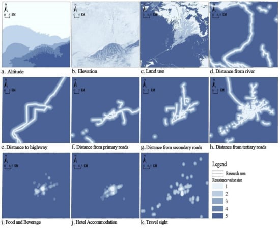
Figure 4.
Resistance distribution of the cultural landscape layers in the Dunhuang urban area by factor.
As well as determining the landscape features of the oasis city and the state of the ecological environment in the heritage corridor, the research process resulted in the invitation of experts in heritage, geography, history, architecture, urban and rural planning, and other related fields, a total of 15 professional and technical personnel, who used the expert scoring method after many demonstrations to determine the weight of each resistance factor, scientifically determining the landscape corridor of the 11 resistance factor weights (Table 3). It can be seen that the slope, land use type, and distance from the river have large weight values; these natural environments and their river conditions have a significant impact on the resistance of the landscape corridor.
Table 3.
Resistance factors and resistance coefficient ratings of the cultural landscape corridors in the Dunhuang urban area.
4.2. Resistance Surface Generation and Historic Landscape Corridor Identification
By converting the data of each resistance factor into raster data according to their determined weights and utilizing the Weighted Sum function in ArcGIS 10.8.2 software to weight and sum the resistance values of the 11 elements, we obtained a comprehensive resistance distribution map of the Dunhuang Oasis region (Figure 5a). As can be seen, areas with high comprehensive resistance values are mainly distributed in the western Gobi area, the southern mountainous area, and the southeastern desert area, exhibiting the characteristics of a “large area and wide surface”. The areas with low comprehensive resistance values are mainly distributed in the central and northern regions and along the transportation arteries, showing the characteristics of an “axial belt-like extension”.
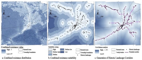
Figure 5.
Integrated resistance analysis and identification of historic landscape corridors in the Dunhuang Oasis zone.
The minimum cumulative resistance value was calculated by applying cost distance analysis, and the integrated resistance surface was finally obtained. Further, based on the relationship between the minimum cumulative resistance difference value and the number of grids and on the ArcGIS statistical histogram information, we can determine the threshold for the change in suitability zoning. According to this threshold value, the surface of the difference value was divided into five levels: high suitability zones, medium–high suitability zones, medium suitability zones, medium–low suitability zones, and low suitability zones (Figure 5b). As we can see, the medium and high-suitability zones are characterized by a clear distribution of “linear corridors”, which are the main components of potential heritage corridors. The northern and eastern fringes are localized “genetic links”. Further, the cost path analysis module was used to generate the path of least resistance and simulate the potential historic landscape corridors in the Dunhuang Oasis area (Figure 5c).
5. Centrality Assessment of Historic Landscape Corridors Based on MCA Modeling
5.1. Calculation of Historic Landscape Weights and Importance Evaluation
The centrality degree of a historic landscape determines the importance grade of the corridor. We adopted a comprehensive evaluation method using following three composite indicators to score a historic landscape: landscape value, protection status, and environmental conditions [47]. The score was set from 1 to 4, and a higher score indicates a greater landscape value. First, the expert scoring method was used to determine the score of each landscape element indicator. The weight of the landscape value indicator was comprehensively determined to be 0.40, the weight of the protection status indicator was 0.25, and the weight of the environmental condition indicator was 0.35. The weighted measures of the 194 existing landscape elements in the Dunhuang Oasis area were determined. It can be seen that the weight of the historic landscape varies significantly: the first-level landscape features sites such as the ancient Silk Road, the Chengwan site, and Leidunzi Xidun beacon, accounting for 25.77% of the total; the second-level landscape includes the Bei Alkali Beach site, the Wushenggong Drainage Mouth site, Baima Pagoda, and other diverse types of sites, accounting for 14.43% of the total; the third-level landscape is represented by the South Lake wind wall, sub-sections 1–4 (South Lake plugging wall), and the ancient canal landscape, accounting for 37.11% of the total; and the fourth-level landscape is dominated by tomb clusters and ancient buildings, accounting for 22.69% of the total.
In order to more accurately assess the classification of corridors and reflect the influence of landscape value on this classification, we superimposed landscape weights with corridor importance. The straightness, intermediation, and proximity of the corridors all show a clear “core–edge” attenuation distribution pattern, with evident spatial clustering characteristics (Figure 6).
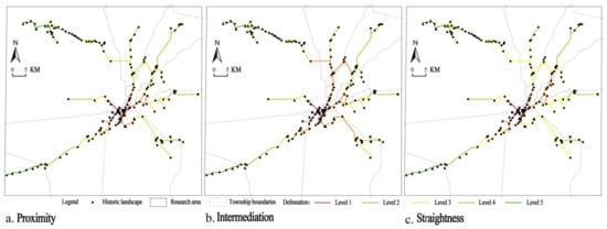
Figure 6.
Straightness, intermediation, and proximity analysis of heritage corridors in the Dunhuang urban area.
5.2. Historic Landscape Corridor Classification
The corridor straightness, intermediation, and proximity measurements were extracted from ArcGIS software and imported into SPSS 18.0 for deviation standardization analysis. All measurement data were linearly transformed so that the results fell within the range of 0~1, and according to the expert scoring method, the straightness weighting was assigned a value of 0.15, the intermediation weighting was assigned a value of 0.35, and the proximity weighting was assigned a value of 0.50. Based on this, the weighted sum function was used to determine the weighted superposition of the three characteristic measurement data in ArcGIS to perform a comprehensive grade analysis of the historic landscape corridor, which was classified using the natural discontinuity method (Figure 7).
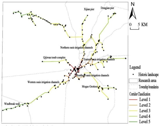
Figure 7.
Classification of landscape corridors in the Dunhuang Oasis area.
It can be seen from the corridor classification that the Dang River in the middle of Dunhuang City is an important node, forming interconnected corridors, including between Dunhuang City, the western and northern part of the local oasis canal, the Mingsha Mountain–Crescent Spring, and other corridors. When constructing corridors in the urban area of Dunhuang, they should be further integrated with the changing city skyline and the cityscape should be visually organized. When constructing landscape corridors for the western and northern local oasis canals, the width of the landscape green belts on both sides of the canals should be controlled, and the planning should be improved by considering the current land use situation. When constructing the Mingsha Mountain–Yueya Spring landscape belt, developers should not only focus on the visual landscape organization within the city, but also highlight the coexistence of the landscape and the symbiosis between the landscape and the sand and water environment. At the same time, a number of feeder corridors formed in the periphery of Dunhuang City, including the southwestern part of the Hong grid and Liuge traffic line based on the South Lake plug wall–Shanque Beacon; the southern trunk canals; the southeastern part of the Mogao Grottoes–Sanwei Mountain road; the eastern part of the road leading to the ruins of the city bay; Dunhuang flood card (Pimple Wells Pier); and the northern part of the Silk Road–Northern Great Wall plug wall–Huangdunying Castle–East Alkali Dun–exclusion of the Wall Dun Beacon road (Figure 8).
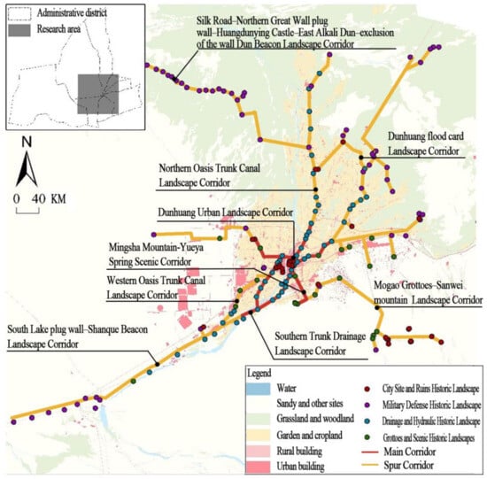
Figure 8.
Labeling of landscape corridors in the Dunhuang Oasis area.
6. Discussion
In terms of research theory, we presented a systematic summary and methodological construction method. Since the development of heritage sites and their historic environments was initiated, the historic urban landscape has gradually gained widespread attention. Bing Zhang (2014) considered the historic urban landscape as a systematic approach to relevance [20]. We propose that the historic urban landscape is not only a comprehensive, systematic, and holistic landscape form, but also a connected approach. We clarify that this landscape form includes all kinds of heritage, landscape resources, and environmental compositions, as well as overall values, and further emphasize the importance and inevitability of the whole landscape. At the same time, we emphasize the basic requirements of authenticity, stability, and dynamism and the combination of relevance and integrity, which provides the basic ideas and paths for future research on historic landscapes.
In terms of research areas, Dunhuang is representative and also unique. Dunhuang’s features are distributed on the basis of the natural environment of the oasis, connecting cross-regional historic landscapes such as the ancient Silk Road, the Great Wall, and rivers, and it is exemplary for the study of the conservation and use of the “Silk Road: Chang’an–Tianshan Corridor Road Network” world heritage site. This study strengthens the shaping of cultural landscape corridors inside and outside the historic cultural city of Dunhuang, which will contribute to the construction and development of Dunhuang as an international tourism city, as well as to the formation of the first national cultural heritage routes in the Hexi Corridor and the national cultural heritage-themed traveling path project [48].
In terms of research methodology, there is a certain degree of inheritance and development in relation to existing research. This study fully combines the related research results of He Ding (2022) and Dai Shanlin (2021), and we first applied the MCR model to identify historic landscape corridors and then applied the MCA model to classify these corridors [31,32]. Regarding historic landscape layer construction, the application of GIS technology integrates historical information and Baidu big data, which enhances the applicability of studying the composition of factors influencing landscape resistance and the generation of resistance surfaces. It can also be used to accurately identify historic landscape corridors. At the same time, through the straightness, intermediation, and proximity analyses of landscape corridors, the historic landscape corridor grades were comprehensively delineated, which will enable the protection of urban cultural resources and the construction of cultural tourism.
7. Conclusions
Identifying historic landscape corridors and ranking the results by analyzing natural and social spatial interactions are rooted in a specific geo-cultural context. From the corridor identification, it can be seen that the four historic landscape layers of the Dunhuang Oasis area, including military defense, city ruins, grottoes and scenic sites, and canals and water conservancy, constitute a comprehensive, systematic, and holistic historic landscape structure of an oasis city, which has a particularly prominent corridor structure. Among these landscape layers, (1) the military defense landscape, located in the northwestern part of the oasis, is more dependent on the adjacent Shule River as a parallel corridor, and the northeastern part and the edge of the oasis are more dependent on the adjacent traffic as a local extension of the corridor, supplemented by the remains of the city site, reflecting the statement “because the river for the plug, use the side of the mountain as a dangerous place”, characteristic of military defense landscapes. (2) The city ruins landscape is mostly dependent on oasis transportation, rivers, drainage, and other elements of the spatial environment and exhibits a “Dang river as the spine of the fishbone” corridor distribution. These military defense and city ruins jointly embody the “city site administration–border defense–ancient trade” model, incentivized by human environmental needs, and these incentives help to achieve border security and access to open channels to ensure that Dunhuang can trade and prosper. (3) The grottoes and scenic landscapes are more dependent on the Gobi Desert, mountains, etc., and combined zones such as the combination of the Mogao Grottoes and West Thousand Buddha Caves due to the intertwined nature of the desert and water bodies of the Mingsha Mountain–Crescent Spring landscape. Here, the relatively independent corridor is located in the southern part of the oasis, exhibiting characteristics related to the history of the Dunhuang Oasis and the nature of the corridor. (4) The canal system and water conservancy landscape consists of four major east–west and south–north canals; the oasis area revitalized the reclamation area, laying the most basic foundation for the growth of towns and cities. The oasis landscape continued to evolve, and city ruins developed; thus, these oasis water networks act as the “blood veins”, supplying life and sustaining the development of the above historic landscapes.
As can be seen from the corridor hierarchy, the Dunhuang Historic Landscape consists of main corridors and feeder corridors. Among them, the main corridor is mostly located in the built-up area of the city, and its construction should fully integrate the policies and demands of historic city protection and urban renewal and reconstruction, strengthen the iconicity of the historic landscape elements, enhance the functional orientation of the landscape corridor, focus on the sense of enclosure of the cultural landscape space, and form a low-intensity skyline characterized by traditional style. At the same time, it emphasizes the connection and shaping of the main corridors and feeder corridors, focuses on the visual connectivity of urban and rural landscapes, and forms an organic combination of historic landscapes with farmlands, irrigation canals, and towns to form a transitional skyline from the urban area to the edge. Therefore, under the support of this research on historic landscape systems at the city level, it is necessary to strengthen landscape functional organization, theme planning and sightline analysis at the level of specific districts and communities to enhance the experiential and participatory nature of the landscape.
Through the above classification and grading study of historic landscape corridors, their importance level, as well as the constant elements of different corridors, can be accurately determined, promoting the scientific protection and effective development of the historic city of Dunhuang. This study is of reference value for the organization of thematic tourism routes in oasis areas. In particular, historic landscape corridors can be graded and categorized, highlighting and delineating the unique heritage characteristics of different corridor segments, and the corresponding grades for tourism facilities can be determined according to the those of the corridor. For example, the oasis city theme characteristics should be highlighted in the main corridor in the center of Dunhuang City, and it should be equipped with regional, high-level tourism service facilities. Meanwhile, for the branch corridors farther away from the central area, the overall presentation of the composite heritage types and the characteristics of the cultural and tourism routes should be the focus.
Author Contributions
Conceptualization, B.F.; methodology, B.F.; software, B.F.; validation, W.L.; formal analysis, B.F.; investigation, B.F.; resources, B.F.; data curation, B.F.; writing—original draft preparation, B.F.; writing—review and editing, B.F.; visualization, B.F.; supervision, W.L.; project administration, B.F.; funding acquisition, B.F. All authors have read and agreed to the published version of the manuscript.
Funding
This research was funded by the Gansu Provincial Science and Technology Program, grant number 24JRZA061, and the Northwest Normal University Young Teachers’ Research Ability Enhancement Program Project, grant number NWNU-LKQN2024-18.
Data Availability Statement
The original contributions presented in this study are included in the article. Further inquiries can be directed to the corresponding author.
Acknowledgments
We sincerely appreciate the reviewers and editors for their relevant suggestions.
Conflicts of Interest
The authors declare no conflicts of interest.
References
- Hussein, F.; Stephens, J.; Tiwari, R. Cultural Memories and Sense of Place in Historic Urban Landscapes: The Case of Masrah Al Salam, the Demolished Theatre Context in Alexandria, Egypt. Land 2020, 9, 264. [Google Scholar] [CrossRef]
- Akbar, S.H.; Iqbal, N.; Van Cleempoel, K. Saddar Bazar Quarter in Karachi: A Case of British-Era Protected Heritage Based on the Literature Review and Fieldwork. Heritage 2023, 6, 3183–3210. [Google Scholar] [CrossRef]
- Qiu, C.; Qiu, N.; Zhang, T. Impacts of construction land expansion on the spatial and temporal evolution of regional cultural landscapes—A case study of Hanjiang Delta, Guangdong Province, China. J. Appl. Ecol. 2022, 33, 3065–3074. [Google Scholar]
- Ferreira, T.C.; Rey-Pérez, J.; Roders, A.P.; Silva, A.T.; Coimbra, I.; Vazquez, I.B. The Historic Urban Landscape Approach and the Governance of World Heritage in Urban Contexts: Reflections from Three European Cities. Land 2023, 12, 1020. [Google Scholar] [CrossRef]
- Macamo, S.; Raimundo, M.; Moffett, A.; Lane, P. Developing Heritage Preservation on Ilha de Moçambique Using a Historic Urban Landscape Approach. Heritage 2024, 7, 2011–2030. [Google Scholar] [CrossRef]
- Yusuf, D.A.; Zhu, J.; Nashe, S.A.; Usman, A.M.; Sagir, A.; Yukubu, A.; Hamma, A.S.; Alfa, N.S.; Ahmed, A. A Typology for Urban Landscape Progression: Toward a Sustainable Planning Mechanism in Kano Metropolis, Nigeria. Urban Sci. 2023, 7, 36. [Google Scholar] [CrossRef]
- Li, J.; Wang, J.; Li, X. Heritage Value Assessment and Landscape Preservation of Traditional Chinese Villages Based on the Daily Lives of Local Residents: A Study of Tangfang Village in China and the UNESCO HUL Approach. Land 2024, 13, 1535. [Google Scholar] [CrossRef]
- White, I.D.; Wang, S., Translators; Landscape and History Since the 16th Century; China Building Industry Press: Beijing, China, 2011; Volume 2. [Google Scholar]
- General Conference of the United Nations Educational, Scientific and Cultural Organization, Nairobi, Nineteenth Session; Recommendation concerning the Safeguarding and Contemporary Role of Historic Areas (Nairobi Recommendation); UNESCO: Paris, France, 1972.
- ICOMOS International Scientific Committee. International Charter on Cultural Tourism; ICOMOS: Paris, France, 1999. [Google Scholar]
- Raymond Lemaire, Herb Stovel. Nara Document on Authenticity; ICCROM: Rome, Italy, 1994. [Google Scholar]
- Twelfth General Assembly of ICOMOS. Charter on the Vernacular Architectural Heritage; ICOMOS: Paris, France, 1999. [Google Scholar]
- Proceedings of the 20th World Congress of Architects of the International Association of Architects, Beijing, China, 23–26 June 1999. Beijing Charter.
- Proceedings of the ICOMOS 15th General Assembly. Xi’an Declaration on the Protection of the Environment in the Vicinity of Historic Buildings, Sites and Areas, Xi’an, China, 17–21 October 2005.
- Vienna Memorandum on the Conservation of Historic Urban Landscapes; International Conference on World Heritage and Contemporary Architecture: Vienna, Austria, 2005; p. 36.
- UNESCO. Proposal on Historic Urban Landscape; UNESCO: Paris, France, 2011. [Google Scholar]
- van Oers, R.; Haraguchi, S.; UNESCO World Heritage Centre. World Heritage Paper27: Managing Historic Cities; UNESCO World Heritage Centre; UNESCO: Paris, France, 2010. [Google Scholar]
- Zhang, S. Introduction to Historic City Conservation: A Holistic Approach to Cultural Heritage and Historic Environment Protection, 3rd ed.; Tongji University Press: Shanghai, China, 2022; Volume 1. [Google Scholar]
- Zhang, S. Urban Conservation Planning—From Historic Environment to Historic Cityscape; Science Press: Beijing, China, 2020. [Google Scholar]
- Zhang, B. “Relatedness” and “System Methods” in the overall protection of historical town -observation and thinking about the concept of “historic urban landscape”. Urban Plan. 2014, 38, 42–48+113. [Google Scholar]
- Liu, C.C. Anchoring and Layering of Historic Urban Landscapes to Recognize and Preserve Historic Cities; Science Press: Beijing, China, 2019. [Google Scholar]
- Müller, J.; Ge, Z.; Hang, C. (Re)shaping Landscapes: China’s Heritage of Human Intervention in the Landscape. Landsc. Archit. 2016, 8, 16–26. [Google Scholar]
- Makhzoumi, J.; Al-Harithy, H.; Bazzi, M. Contextualizing UNESCO’s Historic Urban Landscape Approach: A Framework for Identifying Modern Heritage in Post-Blast Beirut. Land 2024, 13, 2241. [Google Scholar] [CrossRef]
- Ma, X.; Sun, J. A Study of Historic Urban Landscape Change Management Based on Layered Interpretation: A Case Study of Dongxi Ancient Town. Land 2024, 13, 2116. [Google Scholar] [CrossRef]
- Samól, W.; Kowalski, S.; Woźniakowski, A.; Samól, P. Where the Second World War in Europe Broke Out: The Landscape History of Westerplatte, Gdańsk/Danzig. Land 2023, 12, 596. [Google Scholar] [CrossRef]
- Zhang, D.; Wang, H.; Cao, X. Progress of Research on Heritage Corridors in China. Urban Dev. Res. 2016, 23, 70–75. [Google Scholar]
- Gao, C.; Li, Y. An overview of research on heritage corridors in China. J. Kunming Univ. Sci. Technol. (Soc. Sci. Ed.) 2018, 18, 101–108. [Google Scholar]
- Wang, X.; Bi, J. Construction of “Eight Rivers” heritage corridor in Xi’an. J. Northwest Univ. (Nat. Sci. Ed.) 2015, 45, 837–841. [Google Scholar]
- Yang, X.; Chen, J. Construction of linear intangible cultural heritage corridor along the Chinese section of the “Silk Road Economic Belt. J. Arid. Land Resour. Environ. 2021, 35, 202–208. [Google Scholar]
- Gong, D.M.; Yuan, X.; Zhang, Q. Analysis of the Operation Mechanism of the United States’ Canal National Heritage Corridor Model and Its Enlightenment for the Protection and Development of Large Linear Cultural Heritage in China. Urban Dev. Stud. 2016, 23, 17–22. [Google Scholar]
- He, D.; Wang, Z.; Wu, H. Construction of Jingdezhen Porcelain Heritage Corridor System Based on MCR and MCA Models. Geogr. Geo-Inf. Sci. 2022, 38, 74–82. [Google Scholar]
- Dai, S.; Liu, S.; Wu, X. Construction of Historical and Cultural Landscape Corridors Based on MCR—A Case Study of Fuzhou City. For. Inventory Plan. 2021, 46, 193–200. [Google Scholar]
- Fan, W.; Zhang, J.; Wang, J.; Shan, B. Traffic Network Pattern and Optimization of the Three Economic Circles in Shandong Province from the Perspective of Space Syntax. Gegraphy Geo-Inf. Sci. 2023, 39, 55–61. [Google Scholar]
- Chen, C.; Xiu, C.; Cheng, L. Matching Score of Disaster Prevention Green Space-Street Network-Population in Large City Based on Multiple Centrality Analysis Model: A Case Study of Shenyang. J. Catastrophology 2016, 31, 219–225. [Google Scholar]
- Zheng, B. Historical Geography of Dunhuang; Gansu Education Press: Lanzhou, China, 2013. (In Chinese) [Google Scholar]
- Feng, B.; Chen, X.; Wang, L. The Composition of the Cultural Space System and the Whole Analysis of its Historical Environment in Han-Dynasty Dunhuang County. J. Arid. Land Resour. Environ. 2019, 33, 201–208. (In Chinese) [Google Scholar]
- Feng, B. Research on the Protection and Regeneration Model About Historical Environment of Cultural Heritage in the West Section of Hexi Corridor. Ph.D. Thesis, Xi’an University of Architecture and Technology, Xi’an, China, 2022. [Google Scholar]
- Wu, R. Investigation and Study of the Hexi Fortress in Han Dynasty; Cultural Relics Publishing House: Beijing, China, 2005. (In Chinese) [Google Scholar]
- Dunhuang Academy. Gansu Provincial Plan for the Construction and Protection of the Great Wall National Cultural Park (Draft); Dunhuang Academy: Dunhuang, China, 2020. (In Chinese) [Google Scholar]
- Dunhuang Urban and Rural Planning Bureau. Protection Planning of the Famous Historical and Cultural City of Dunhuang; Dunhuang Academy: Dunhuang, China, 2015. (In Chinese) [Google Scholar]
- Wang, H.Y.; Kuang, Y.Q.; Wen, X.J.; Song, Z.P.; Liu, D.H. Ecological network construction and corridor optimization in Guangdong-Hong Kong-Macao Greater Bay Area. China Environ. Sci. 2022, 42, 2289–2298. [Google Scholar]
- Chen, N.N.; Kang, S.Z.; Zhao, Y.H.; Zhou, Y.J.; Yan, J.; Lu, Y.R. Construction of ecological network in Qinling Mountains of Shaanxi, China based on MSPA and MCR model. Chin. J. Appl. Ecol. 2021, 32, 1545–1553. (In Chinese) [Google Scholar]
- Yu, K.; Li, W.; Li, D.; Li, C.; Huang, G.; Liu, H. Exploration of Suitability Analysis Methods for Heritage Corridors in Rapid Urbanization Areas: A Case Study of Taizhou City. Geogr. Res. 2005, 24, 69–76+162. [Google Scholar]
- Li, X.; Li, J.; Hou, W. Fine-Grained Spatial Simulation and Corridor Optimization of Regional Ecological Networks: A Case Study of the Fenhe River Basin. Geogr. Geoinf. Sci. 2020, 36, 14–20+55. [Google Scholar]
- Chen, Z.; Kang, D.; Wei, X.; Zhang, L. Construction of Yuhjiang County’s Ecological Network Based on MSPA and MCR Models. Resour. Environ. Yangtze River Basin 2017, 26, 1199–1207. [Google Scholar]
- Li, H.; Wang, Z. Exploration of the System of Corridors of War Heritage Based on GIS Spatial Analysis. Urban Dev. Stud. 2017, 24, 86–93. [Google Scholar]
- Hu, M.; Jin, C. Application Research on the Protection System of Historical and Cultural Cities Based on GIS; Southeast University Press: Nanjing, China, 2012; pp. 48–55. [Google Scholar]
- Gansu Province, Focusing on the ‘Eight One’ Cultural Brand to Promote the Development of Cultural Heritage. Available online: http://gansu.gscn.com.cn/system/2024/02/20/013099710.shtml (accessed on 20 February 2024).
Disclaimer/Publisher’s Note: The statements, opinions and data contained in all publications are solely those of the individual author(s) and contributor(s) and not of MDPI and/or the editor(s). MDPI and/or the editor(s) disclaim responsibility for any injury to people or property resulting from any ideas, methods, instructions or products referred to in the content. |
© 2025 by the authors. Licensee MDPI, Basel, Switzerland. This article is an open access article distributed under the terms and conditions of the Creative Commons Attribution (CC BY) license (https://creativecommons.org/licenses/by/4.0/).