Abstract
In recent decades, natural disasters have increased drastically, with slope movements being the most damaging geological hazard, causing thousands of deaths and considerable economic losses. To reduce these losses, it is necessary to carry out cartographies that spatially delimit these risks, preventing and mitigating the effects through the analysis of susceptibility in areas of great environmental value, as is the case of the Arribes del Duero Natural Park. For this purpose, different statistical methods combined with Geographic Information Systems have been developed. The susceptibility assessment methodology is carried out by integrating different thematic layers: lithology, geomorphology (slopes, curvature, aspect), hydrogeology and vegetation, performing map algebra and taking into consideration their weighting using deterministic methods (analytical hierarchy method). The susceptibility results are grouped into Very High, High, Medium, Low and Very Low so that the areas of Very High susceptibility correspond to areas of the high slope, without vegetation, south facing, with a lithology of quartzites, metapelites, and gneisses (canyons, steep valleys) and, in the case of very low susceptibility, with a lithology of quartzites, metapelites, and gneisses, On the contrary, the sectors of lower susceptibility coincide with flat areas, denser vegetation, north facing, with a lithology of conglomerates, pebbles, sands and clays, such as erosion surfaces or valley bottoms. The analysis carried out in this current investigation will allow the territorial delimitation of problem areas and the establishment of risk mitigation and management measures.
1. Introduction
Natural disasters, in general terms, have increased dramatically in recent decades. Among the most damaging geological hazards are landslides or mass movements, which result in thousands of deaths and considerable economic losses [1,2]. The factors that play a role in enhancing these movements are conditioning factors and triggering factors [3]. The conditioning factors show the inherent characteristics of the terrain that make slopes susceptible to landslides, such as geology, geomorphology (slopes, curvature and aspect) and land use. Triggering factors, on the other hand, are extraordinary events such as prolonged rainfall, seismic effects or anthropogenic activities [4,5]. Landslides can be defined as mass movements of the ground, i.e., by gravity, and cause the collapse of steep slopes [6], which can be classified into landslides, avalanches and flows, both of rocks and soils [7].
Currently, landslides are one of the most common natural hazards which affect all regions of the world and cause great losses. Thus, in order to reduce them, there is a need to identify such events as a preventive way to mitigate risks by assessing their susceptibility, which can be quantitative or qualitative, based on the probability of occurrence under a set of geoenvironmental conditions [8,9,10,11].
In recent years, different methods have been developed for the elaboration of susceptibility maps that use Geographic Information System (GIS) techniques combined with statistical methods, such as multivariate analysis using regular discriminant grids, analysing the coefficients of each function based on the variables, making it possible to determine potentially unstable areas [12,13,14,15,16,17]. In addition, pairwise comparison methodologies are suitable for validating the results in different sectors [18], and in view of their usefulness and applicability, different specific software has been developed [19,20]. The use of landslide susceptibility maps has been used by different authors to predict landslides and their consequences, using bivariate statistical analysis or conditional analysis together with GIS tools, although it could be significantly improved by considering different types of landslides and using data with similar resolution in the case of bivariate analysis. As for the conditional analysis, being a simple method, it presents a certain operational complexity that does not allow the procedure to be carried out more times in the same area, having to use other techniques, such as the shell programme, which would entail more time and the possibility of errors [21,22,23,24,25].
One of the most widely used techniques consists of the integral interpretation of thematic base maps and their interrelation, with subsequent statistical treatment, by using direct or indirect, deterministic or non-deterministic methods [26,27]. However, nowadays, due to the wide availability of aerial images (aerial photos, satellite images) in a digital format, it is possible, by means of GIS, to integrate the different thematic layers and obtain a map of susceptibility to these movements. This method makes it possible to interact between thematic maps and to weigh each of the factors by establishing weights according to territorial characteristics, which can sometimes lead to a certain subjectivity [28,29]. To minimise this bias in the weighting process, statistical methods such as the Analytical Hierarchy Process (AHP) are used to provide a more detailed model for the elaboration of a landslide susceptibility map with objective empirical algorithms based on prior determination and sampling in laboratory analysis [30,31,32,33,34,35,36,37,38]. It is a very useful mathematical method for quantifying landslide triggers, as it allows for a simple and quick definition of the susceptibility map [38]. Likewise, susceptibility cartography is a very effective preventive measure because it is a basic tool for a correct assessment of the possible impact of natural processes on the territory. This cartography in itself constitutes a risk prevention measure, either by avoiding the location of human activities in areas of certain risk or by adopting protection measures for those elements exposed to risk when there is no other alternative. This way, it also serves to establish territorial zoning based on the possibility that landslides may occur and to establish areas prone to development [39,40].
The objectives of this article are to determine and map the sectors susceptible to landslide movements in the Arribes del Duero Natural Park based on existing land movements and their territorial characteristics and to identify the processes that cause them by providing useful information in the response phase in the event of a possible emergency.
2. Materials and Methods
The study area (Figure 1) in which this study will be carried out is the Arribes del Duero Natural Park, which is located in the west of Castilla y León, specifically in the northwest of the province of Salamanca and southwest of Zamora, along the Duero River and bordering Portugal. It is a protected natural area which comprises approximately 62,000 Ha and 38 municipalities. It stretches from the south of the park in Puerto Seguro (province of Salamanca) to the north part of the province of Zamora, where the towns of Fonfría, Pino and Villalcampo are located. From a bioclimatic point of view, it has a Mediterranean macroclimate, specifically a Mediterranean pluvial-stationary oceanic climate, with mild winters and very hot and long summers (average temperatures of 17.1 °C and rainfall of 500 mm) in the valley areas, compared to the climate of the plain area, (with temperatures of 12.2 °C and rainfall of 750 mm [41,42]. The landscape of the peneplain is undulating (with heights between 700 and 800 m); meanwhile, the steep slopes of the canyons and valleys (with heights of 130 m) of the Duero, Tormes, Uces, Huebra and Águeda rivers stand out in the valley areas. In terms of vegetation, the peneplain is a rich mosaic of species including Quercus ilex, Quercus pyrenaica, Quercus suber and Quercus faginea), other tree species, such as Fraxinus angustifolia and scrub species such as Cytisus multiflorus and Cytisus oromediterraneus), and also pastures and dry crops, such as wheat (Triticum sp.), barley (Hordeum vulgare), rye (Secale cereale) and vines (Vitis vinifera) can also be found. Olive trees (Olea europaea) and almond trees (Prunus dulcis) are still grown on terraces on the slopes. Finally, there are large dams and hydroelectric power stations, making it one of the areas with the greatest hydroelectric potential on the Iberian Peninsula [43,44].
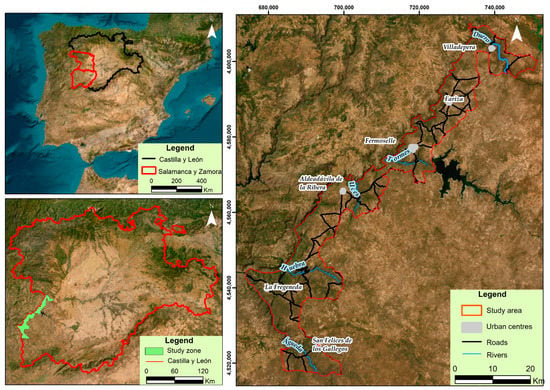
Figure 1.
Location map of the study area.
The analysis of landslide susceptibility is carried out using non-deterministic methods, with thematic cartography in which conditioning factors for each type of landslide are identified. Susceptibility maps are obtained from this cartography of passive or conditioning factors [43]. Thus, the methodology followed in this article (Figure 2) combines fieldwork (the cartography must be validated via the direct observation of events in landslide areas and photo-interpretation of multi-temporal aerial photographs, with resolutions between 80 and 10 m) and desk-based work (each cartography has been made by using the Digital Terrain Model (DTM). All the above information has been obtained from the database of the Castilla y León Agrarian Technological Institute (ITACYL) [43,44,45,46,47,48]. Firstly, a compilation of information from historical events is carried out: cartographies from different organisations, analysis of aerial photographs from different periods, interpretation of orthophotographs and also direct observation in the field [43,44]. Then, the susceptibility or possibility of each area being affected by a given process is analysed. It shows the special probability of occurrence and results in the susceptibility map. This map takes into consideration the factors that control the occurrence of landslides. In this way, each conditioning factor is represented using thematic maps, and after using GIS techniques, they are also qualitatively reclassified using multivariate statistical methods into five classes according to behaviour in the face of potential landslide movements by assigning numerical values, thus simplifying the original map while retaining important information on landslide hazards. Five classes or degrees of susceptibility are established for ease of interpretation [49,50].
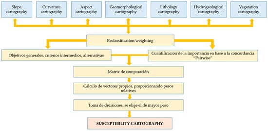
Figure 2.
Methodological scheme.
The concordance matrix has been used as a statistical tool to find out the relationship of qualitative variables when combining the different categories. It shows the frequency with which particular combinations of categories occur for each of the variables. It allows comparisons to be made between pairs of items in a set to be recorded and organised, providing a useful structure for analysis and decision-making based on systematic comparisons.
Thematic factors are specific and different according to each zone [48]. In this study, seven thematic maps were evaluated. Each one corresponds to each factor analysed, and they are based on the Digital Terrain Model (DTM): lithological map, geomorphological domain map (slopes, curvature and aspect), hydrogeological map and vegetation map. Each of these maps is explained below:
- -
- Geomorphological susceptibility: Geomorphological analysis is an essential step in landslide analysis [43]. This map has been drawn up on the basis of the geomorphological characteristics and distinguishes a series of units favourable to slope movements and the development of active processes.
- -
- Susceptibility of slopes: The relief is a determining factor in the appearance of instability on a slope, being the angle of the slope the most important morphological parameter, as it will determine if slope movements exist and even the type of movements [43,51]. The slope map is made from a DTM digital elevation model, which provides a high-precision (1 m) map of the slopes using GIS tools.
- -
- Susceptibility by curvature: The morphometry of the slope is one of the most important parameters in the possibility of slope movements. As a concave slope tends to accumulate more water after precipitation, it can retain it for a longer period of time, increasing the probability of occurrence of these movements. On the other hand, convex slopes correspond to rocky outcrops; thus, they decrease the probability of these landslides [52]. The thematic map has been made by using DTM and taking into consideration the values of slopes and aspects. Cartography of slopes with a resolution of 1 metre has been obtained.
- -
- Susceptibility by aspect: Aspect represents the direction of the slope face. It is necessary to take into consideration the influence of sills and shallows, which have a local effect as a conditioning factor in slope instability [52]. This map has been elaborated, as the previous one, by using the DTM.
- -
- Lithological susceptibility: This is a parameter that will determine the potentiality of movements for each type of material. The analysis of the physical-mechanical properties (composition, deformability, degree of alteration, etc.) makes it possible to predict the stability or instability of a slope under certain triggering or active factors [45]. Thus, stronger rocks are more resistant to driving forces compared to weaker rocks and are, therefore, less prone to landslides [52]. For the creation of this map, the geological cartographies of the Spanish Geological Mining Institute (IGME) at a scale of 1:50,000 have been taken into consideration together with the DTM model. A more detailed lithological map has been obtained. Based on this map, the different lithologies were grouped into five degrees of susceptibility according to different parameters (Table 1).
 Table 1. Lithological strength assessment.
 - -
- Hydrogeological susceptibility: It takes into consideration the structural and lithological characteristics, as well as their degree of alteration and permeability. This way, the loss of stability in the different materials is directly related to the position of the water table since water reduces the shear resistance because of interstitial pressures or increases the shear stresses because of soil saturation [44]. This map has been made taking into consideration the lithological cartography, as well as the permeability of the different materials.
- -
- Vegetation susceptibility: Landslides are inversely associated with vegetation density [52]. Thus, the presence of vegetation controls the processes of weathering and erosion because it acts as a brake and plays a conditioning role in whether or not slope instability phenomena exist [50,53]. In order to draw up this map, different vegetation maps of the area, the distribution of vegetation in a semi-quantitative way, its presence or absence and type, and the reclassification used for the calculation of Factor C for water erosion risks, have been taken into consideration [54].
Once each of the cartographies has been produced, each of the thematic factors is reclassified and weighted into five different classes. In order to do this, the weighted superimposition technique is used, which allows a map to be developed by using superimpositions of several raster layers and giving weight to each of them according to their importance. Firstly, a concordance or “Pairwise” evaluation is established, which allows a relational analysis of each pair of parameters used in the assessment of risk susceptibility, by means of which the level of importance of each parameter is qualified and quantified by assigning a value between 1 and 4 (Table 2). It depends on the predominance of one parameter over another, and it is based on the movements inventoried in the study area. Then, by using the Analytical Hierarchies Method (AHM), the weights of each susceptibility parameter are determined (Table 3) according to the following steps (Figure 3): first, the general objectives, intermediate criteria and alternatives being considered in the decision are identified and organised in a hierarchical structure; second, a systematic comparison of pairs of elements within each hierarchical level is made by using a relative preference scale, which will tell whether one alternative or the other is more favourable; third, comparison matrices are constructed from the evaluations of the pairs of elements and each of which reflects the relative preferences of the elements at a specific level of the hierarchy; fourth, the eigenvectors of the comparison matrices are calculated, which will provide the relative weights for the elements at each hierarchical level; finally, decisions are made using the information obtained from the priorities. The best option selected is the one with the highest weight [55]. Once the weighting of each parameter has been assigned, the susceptibility map is obtained by the weighted overlay method using ArcGIS 10.8 software. All the cartographies, both thematic and susceptibility, are divided into two zones (according to the two provinces that make up the Park, Salamanca and Zamora) due to the fact that the study area is very large, losing details if they were presented in a single zone.

Table 2.
Quantification of significance based on Pairwise matching.

Table 3.
Determination of the weights of each susceptibility parameter by the Analytical Hierarchy Method.
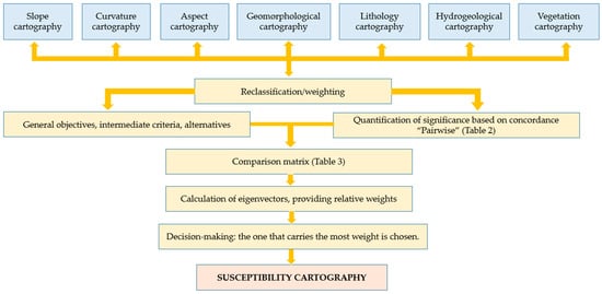
Figure 3.
Weighting methodology.
3. Results
3.1. Thematic Cartographies
Each of the cartographies described below has been reclassified according to five susceptibility classes (Table 4): Very Low (value 1), Low (value 2), Medium (value 3), High (value 4) and Very High (value 5).

Table 4.
Reclassification of thematic cartographies.
- Cartography of slope susceptibility: In areas with steep slopes, landslides occur because the weathered material is not stable at that slope, causing some triggering factor (high rainfall) to activate the detachment of the overlying mass. On the other hand, in areas of medium and low slopes, there are areas of drainage concentration, which influences the greater or lesser infiltration, so the hydrostatic pressure causes the detachment of materials or rocks. Thus, the cartography obtained (Figure 4) shows that susceptibility is very high (canyon areas, embedded valleys or quartz dykes) in the steeper areas, while in medium–high slope areas (20–35°), they are less steep or not as embedded as the previous ones (valleys, colluviums or domes). In turn, medium susceptibility areas are those of medium slopes (15–20°), such as crags or hills. Finally, the areas with lower slopes have low susceptibility (slopes between 5 and 15°), which are slightly inclined areas such as dejection cones, glaciers or ravines, and very low susceptibility, which are flat areas such as valley bottoms, navas, surfaces or terraces.
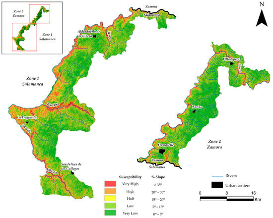 Figure 4. Slope susceptibility map.
 - Cartography of susceptibility by aspect: This map is based on the four aspects. Four susceptibility classes are obtained (Figure 5): Very high (South), High (West), Low (East) and Very low (North). The first two include sectors with an SW aspect that coincide with the Duero Canyon and the sloping valleys of the most abundant tributaries of the Duero. On the other hand, the Low and Very low susceptibility corresponds to areas where exposure is low because of the lack of topographic projections (surface or floodplain areas).
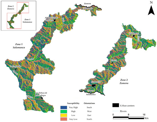 Figure 5. Map of susceptibility by orientation.
 - Cartography of susceptibility by curvature: It can be observed that the negative values correspond to convex morphologies, while concave and flat morphologies have positive values. Thus, convex shapes have a very high susceptibility, while flat areas have a low susceptibility. At the same time, this map allows us to differentiate between valley bottoms, erosion surface areas, terraces and ridges, among others. The degree of curvature, which is directly related to the ease of fall or retention of different materials, such as soil remediation, is also important.
- Lithological susceptibility cartography: The calculation of this susceptibility has been based on the valuation estimated from the average value of the properties that determine the resistance of each lithology. Thus, in the map (Figure 6), the five classes are: Very high (quartzites, metapelites and gneisses), High (slates and schists), Medium (leucogranites, biotitic granites and gran-odiorites), Low (porphyritic granites) and Very low (conglomerates, sands and clays).
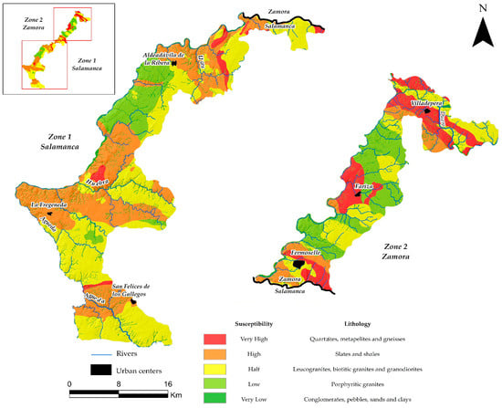 Figure 6. Lithological susceptibility map.
 - Geomorphological susceptibility cartography: It can be seen (Figure 7) that the areas of greatest susceptibility correspond to the steeper slopes, such as the canyon or the boxed valleys (among others). On the other hand, the colluvium, valleys and domes have a high susceptibility; the berrocales, hills and granitic lehm have a medium susceptibility; the dejection cones, the “raña” (Plio-Pleistocene formation on a flat surface with semi-rounded ridges) and glacis have a low susceptibility and, finally, the flat or lower slope areas such as valley bottoms, terraces, navas and surfaces have low susceptibility.
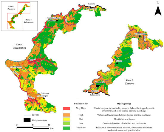 Figure 7. Geomorphological susceptibility map.
 - Hydrogeological susceptibility cartography: The following degrees of susceptibility are observed (Figure 8): Very high corresponds to the Quaternary unit formed by conglomerates, pebbles, sands and clays; High is the granitic unit I (formed by leucogranites and biotitic granites); Medium is formed by the granitic unit II (porphyritic granites); Low corresponds to the metasedimentary unit and, lastly, Very Low is formed by the quartzite unit and the gneisses.
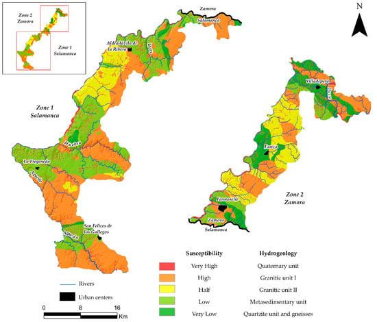 Figure 8. Hydrogeological susceptibility map.
 - Vegetation susceptibility cartography: In this map (Figure 9), we can observe that in areas without vegetation, as in the Duero Canyon, the susceptibility is very high and important external geodynamic processes that favour the instability of the materials that cover the slope are presented. In areas with the presence of herbaceous plants and crops (such as seasonal perennial grasslands or fallow land), the susceptibility is high, with a somewhat lower probability of these movements happening compared to the previous one. On the other hand, the sectors with subshrubby vegetation (cantuesares, tomillares and jarales or piornales and cambronales) and shrubby vegetation (fruit-bearing shrub formations and rocky areas with jaral-brezal) have medium and low susceptibility, respectively, since that they have a greater size than in the case of herbaceous vegetation. Finally, the areas with arboreal habitats (holm oak and cork oak groves, deciduous forests, holm oak meadows or oak meadows) have the lowest susceptibility because they have a more developed root system, favouring the stability of the slope by retaining and fixing the sediment.
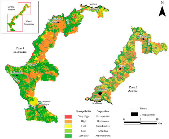 Figure 9. Vegetation susceptibility map.
3.2. Susceptibility Cartography
To obtain the susceptibility cartography (Figure 10), the weight of each parameter was established by taking into consideration the values given to each susceptibility unit: Very Low (1), Low (2), Medium (3), High (4) and Very High (5). The established weighting has been applied to each parameter by using the Final Valuation (FV) equation (Equation (1)). To perform this by using map algebra, the parametric cartographies were multiplied by their corresponding weighting.
FV = (0.26 × slopes) + (0.22 × curvature) + (0.17 × vegetation) + (0.13 × geomorphology)
+ (0.10 × lithology) + (0.07 × hydrogeology) + (0.05 × aspect)
+ (0.10 × lithology) + (0.07 × hydrogeology) + (0.05 × aspect)
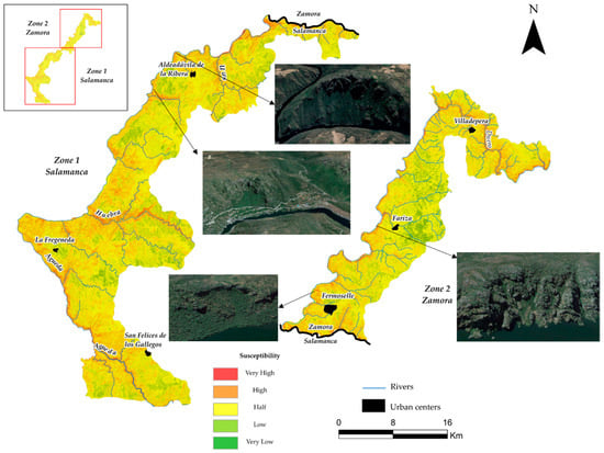
Figure 10.
Susceptibility map.
According to the susceptibility cartography obtained, it can be seen that the areas with a very high possibility of slope movement occupy 5.1% of the area and correspond to the Duero River canyon and the valleys of the most abundant tributaries (Águeda, Huebra and Tormes), due to the high slopes and non-existent vegetation. In these areas, it is observed that colluvial landslides (Figure 11A), soil reptation (Figure 11C), granitic projections with associated landslides (Figure 11D,E), circular rupture scars with colluvial deposits down to the course of the Duero River (Figure 11F) and scars in the form of a circular curve of great amplitude with associated landslides (Figure 11G). On the other hand, the high susceptibility sectors, with an extension of 18.6%, correspond to the geomorphological domains of valleys, colluviums, escarpments (Figure 11B) and domatic forms, such as the one observed in the area between La Fregeneda and the river Huebra.
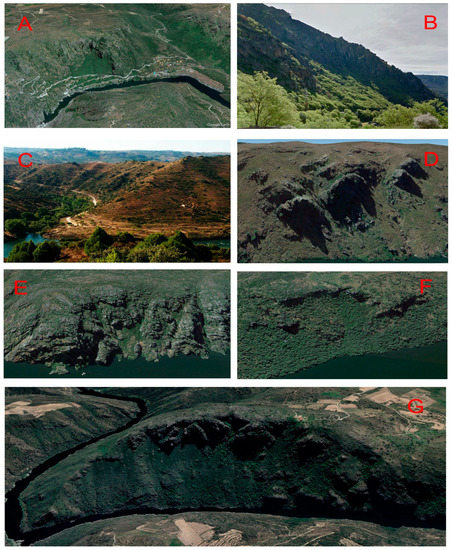
Figure 11.
Colluvial landslide affecting the access to the Aldeadávila Hydroelectric Power Station (A). Detail of the escarpment and the colluvium at the foot, covered with vegetation (B). Mouth of the River Tormes into the River Duero at Ambasaguas-Villarino, where soil reptation and structural measures with terraces can be observed (C). Granite outcrops with associated landslides of the ledges or “viseras” in Fermoselle (D,E). Circular break scarp with colluvial deposits up to the course of the Duero River (F). Wide curca scar with associated landslides in Aldeadávila de la Rivera (G).
The medium susceptibility is the most extensive, with 65.7% of the surface area, corresponding to the crags and hills, berrocales and hills with a lithology of leucogranites, biotitic granites and granodiorites and vegetation of the subshrub type that already give them a greater fixation to the soil, unlike the previous ones, are found. As for the low susceptibility areas, they cover an area of 10.6% and are characterised by having slightly sloping surfaces, including glacis, raña and dejection cones, with shrub-type vegetation. They are located in very specific areas, such as in the Cerezal de Peñahorcada mountain ranges. Finally, the sectors of very low susceptibility are scarce and punctual, only occupying 0.04% of the area, corresponding with areas such as erosion surfaces, valley bottoms and terraces, with a high density of tree vegetation, which means that the rest of the parameters also have low values.
4. Discussion
Landslides are not instantaneous phenomena but occur gradually, conditioned by numerous thematic factors that act directly or indirectly. In Arribes del Duero, the most common factors used in various studies of this type have been selected [45,46,47,48]: geomorphology (slopes, curvature, aspect), lithology, and hydrogeology. To analyse and predict these landslides, susceptibility maps are used; however, the reliability of these maps must be considered, and both the limitations and advantages of their use must be considered [56].
Firstly, the quality of the cartography is important; a robust and reliable methodology that integrates different data sources and analysis techniques should be used. In this study, fieldwork, including direct observation of events and photo-interpretation of multi-temporal aerial photographs, was combined with desk-based mapping of conditioning factors. This integration, carried out using GIS, makes it possible to obtain a more complete and accurate susceptibility map [43,44].
However, the methodology followed has certain limitations, mainly depending on the quality and resolution of the DTMs; a high resolution entails a long calculation time, in addition to the need for more powerful workstations. All this must be considered when interpreting the results, as any error in these data can affect the final results of the susceptibility maps.
It is important to highlight that the choice of conditioning factors used also influences the reliability of the maps, and among these factors, the most important are slopes and vegetation. With regard to slopes, Arribes del Duero is characterised by two clearly differentiated areas, the canyon areas and sloping valleys, with high slopes, and the peneplain areas, with medium and low slopes. In the areas with steep slopes, landslides occur because the weathered material is not stable, causing some external factor to activate this gravitational movement, unlike what happens in the areas with medium and low slopes, where drainage is concentrated, influencing the greater or lesser infiltration. On the other hand, as regards vegetation, its presence increases the stability of the surfaces [57,58], the study area is characterised by a great diversity of vegetation, although there are also areas where there is none, such as the Duero Canyon, and it is there where susceptibility is higher, due to the existence of external geodynamic processes that favour the instability of the materials. In areas with vegetation, susceptibility varies depending on the density and tree size, so in areas with herbaceous plants and crops (low density and small size), susceptibility is high, whereas, in areas with tree size (holm oak and cork oak groves), susceptibility is lower because they have a more developed root system, favouring the stability of the slope.
Another important aspect to be considered is the selection of the weighting method of the conditioning factors, as it must be appropriate to these factors in order to obtain more accurate and reliable results. In this study, the evaluation of the concordance or “Pairwaise” has been used for subsequently analysis using the AHP method [56].
In terms of advantages, susceptibility maps provide useful information on the most landslide-prone areas. Additionally, if necessary, these maps can be validated and supplemented by detailed investigations. They also provide valuable information for areas where no previous events have been documented, helping to identify possible risks and take preventive measures. In addition, in emergency situations, these maps can be used in the response phase to identify more susceptible areas and make informed decisions.
In the specific case of the Arribes del Duero Natural Park, the susceptibility of gravitational movements, and indirectly, their associated risks, had not been previously analysed, unlike others, such as erosive risks [57] and natural hazards [59]. Thus, with the analysis of gravitational risks, it is possible to carry out, in the future, a study to analyse the natural risks of this park, to establish which areas are more susceptible to each risk and, with this, to establish measures to mitigate and manage the natural risks.
In summary, susceptibility cartography is a useful tool to determine the most susceptible areas; however, it is necessary to consider the limitations associated with the quality of the data, the selection of the conditioning factors and their weighting. Finally, it also provides additional information for those areas where no such events have been documented and useful information in the response phase to a possible emergency.
5. Conclusions
The susceptibility cartography, in addition to delimiting areas more prone to landslides, can be used in the future as a starting point to establish structural and non-structural measures for mitigation and management in territorial planning and human activities.
In the susceptibility cartography obtained, five susceptibility units are distinguished: Very high: these are areas with a very high possibility of landslide movement, with an extension of 5.1% and correspond to the Duero River canyon, the valleys of the most abundant tributaries (Águeda, Huebra and Tormes), such as: colluvial landslides, soil reptation, granitic projections, circular breakage escarpments, among others. Sectors of high susceptibility are the second most extensive, with 18.6%, corresponding to the geomorphological domains of valleys, colluvium, escarpments and domatic forms. Medium susceptibility, typical of the berrocales, with sub-shrub vegetation, is the most extensive, with 65.7%. Low susceptibility, is located in areas of slight inclination, such as glacis, rañas and dejection cones, and in addition to having more developed shrub-type vegetation, occupies an extension of 10.6%. Very low susceptibility corresponds to flat areas such as erosion surfaces, valley bottoms and terraces with higher density vegetation of arboreal type, being the least extensive, occupying barely 0.04% of the surface.
In view of the results, Very High susceptibility is present in specific areas, where it will be necessary to take some kind of measure to reduce the occurrence of landslides. Likewise, the susceptibility that most affects the study area is the medium susceptibility, which is not as important as the previous one, but where it is also necessary to establish structural and non-structural measures to mitigate these movements.
Finally, this cartography could be improved with the use of drones (UAVs) and orthophotos of maximum resolution, which would allow high-precision centimetric models to be made. This has the disadvantage of high data processing times and the need for a workstation capable of processing such data.
Author Contributions
Conceptualisation, L.M., A.M.-G., M.C. and C.E.N.; methodology, L.M., T.C. and A.M.-G.; software, L.M. and A.M.-G.; validation, L.M., T.C. and A.M.-G.; formal analysis, L.M., A.M.-G., M.C. and C.E.N.; investigation, L.M. and A.M.-G.; resources, L.M., A.M.-G., M.C., C.E.N. and T.C.; data curation, L.M. and A.M.-G.; writing, original draft preparation, L.M. and A.M.-G.; writing, review and editing, L.M. and A.M.-G.; visualisation, L.M. and A.M.-G.; supervision, A.M.-G.; project administration, A.M.-G.; funding acquisition, A.M.-G. All authors have read and agreed to the published version of the manuscript.
Funding
Grant 131874B-I00 funded by MCIN/AEI/10.13039/501100011033.
Data Availability Statement
Not applicable.
Acknowledgments
This research was assisted GEAPAGE research group (Environmental Geomorphology and Geological Heritage) of the University of Salamanca.
Conflicts of Interest
The authors declare no conflict of interest.
References
- Keefer, D.K.; Larsen, M.C. Assessing landslide hazards. Science 2007, 316, 1136–1138. [Google Scholar] [CrossRef]
- Huang, R.; Fan, X. The landslide story. Nat. Geosci. 2013, 6, 325–326. [Google Scholar] [CrossRef]
- Guzzetti, F.; Mondini, A.C.; Cardinali, M.; Fiorucci, F.; Santangelo, M.; Chang, K.T. Landslide inventory maps: New tools for an old problem. Earth-Sci. Rev. 2012, 112, 42–66. [Google Scholar]
- Chen, C.W.; Chen, H.; Wei, L.W.; Lin, G.W.; Iida, T.; Yamada, R. Evaluating the susceptibility of landslide landforms in Japan using slope stability analysis: A case study of the 2016 Kumamoto earthquake. Landslides 2017, 14, 1793–1801. [Google Scholar] [CrossRef]
- Getachew, N.; Meten, M. Weights of evidence modeling for landslide susceptibility mapping of Kabi-Gebro locality, Gundomeskel area, Central Ethiopia. Geoenvironmental Disasters 2021, 8, 6. [Google Scholar] [CrossRef]
- Guo, W.; Xu, X.; Zhu, T.; Zhang, H.; Wang, W.; Liu, Y.; Zhu, M. Changes in particle size distribution of suspended sediment affected by gravity erosion: A field study on steep loess slopes. J. Soils Sediments 2020, 20, 1730–1741. [Google Scholar] [CrossRef]
- Zhu, T.; Xu, X.; Zhu, A. Spatial variation in the frequency and magnitude of mass movement in a semiarid, complex-terrain agricultural watershed on the Loess Plateau of China. Land Degrad. Dev. 2019, 30, 1095–1106. [Google Scholar] [CrossRef]
- Fell, R.; Corominas, J.; Bonnard, C.; Cascini, L.; Leroi, E.; Savage, W.Z. on behalf of the JTC-1 Joint Technical Committee on Landslides and Engineered Slopes. Guidelines for landslide susceptibility, hazard and risk zoning for land use planning. Eng. Geol. 2008, 102, 85–98. [Google Scholar] [CrossRef]
- Wang, H.J.; Zhang, L.M. Landslide Susceptibility Updating Considering Real-Time Observations. In Geo-Congress 2019: Soil Erosion, Underground Engineering, and Risk Assessment; American Society of Civil Engineers: Reston, VA, USA, 2019; pp. 107–113. [Google Scholar]
- Wang, H.J.; Xiao, T.; Li, X.Y.; Zhang, L.L.; Zhang, L.M. A novel physically-based model for updating landslide susceptibility. Eng. Geol. 2019, 251, 71–80. [Google Scholar] [CrossRef]
- Du, J.; Glade, T.; Woldai, T.; Chai, B.; Zeng, B. Landslide susceptibility assessment based on an incomplete landslide inventory in the Jilong Valley, Tibet, Chinese Himalayas. Eng. Geol. 2020, 270, 105572. [Google Scholar] [CrossRef]
- Bednarik, M.; Pauditš, P. Different ways of landslide geometry interpretation in a process of statistical landslide susceptibility and hazard assessment: Horná Súča (western Slovakia) case study. Environ. Earth Sci. 2010, 61, 733–739. [Google Scholar] [CrossRef]
- Constantin, M.; Bednarik, M.; Jurchescu, M.C.; Vlaicu, M. Landslide susceptibility assessment using the bivariate statistical analysis and the index of entropy in the Sibiciu Basin (Romania). Environ. Earth Sci. 2011, 63, 397–406. [Google Scholar] [CrossRef]
- Yilmaz, I. Comparison of landslide susceptibility mapping methodologies for Koyulhisar, Turkey: Conditional probability, logistic regression, artificial neural networks, and support vector machine. Environ. Earth Sci. 2010, 61, 821–836. [Google Scholar] [CrossRef]
- Moreiras, S.M. Landslide susceptibility zonation in the Rio Mendoza valley, Argentina. Geomorphology 2005, 66, 345–357. [Google Scholar] [CrossRef]
- Dillon, W.R.; Goldstein, M. Multivariate Analysis. Methods and Applications; John and Willey and Sons: Hoboken, NJ, USA, 1986. [Google Scholar]
- Baeza, C.; Corominas, J. Assessment of shallow landslide susceptibility by means of multivariate statistical techniques. Earth Surf. Process. Landf. J. Br. Geomorphol. Res. Group 2001, 26, 1251–1263. [Google Scholar] [CrossRef]
- Irigaray, C.; Lamas, F.; El Hamdouni, R.; Fernández, T.; Chacón, J. The importance of the precipitation and the susceptibility of the slopes for the triggering of landslides along the roads. Nat. Hazards 2000, 21, 65–81. [Google Scholar] [CrossRef]
- Ritchie, A.M. Evaluation of rockfall and its control. Highw. Res. Rec. 1963, 17, 13–28. [Google Scholar]
- van Dijke, J.J.; van Westen, C.J. Rockfall hazard: A geomorphologic application of neighbourhood analysis with ILWIS. ITC J. 1990, 1, 40–44. [Google Scholar]
- Clerici, A.; Perego, S.; Tellini, C.; Vescovi, P. A procedure for landslide susceptibility zonation by the conditional analysis method. Geomorphology 2002, 48, 349–364. [Google Scholar] [CrossRef]
- Süzen, M.L.; Doyuran, V. Data driven bivariate landslide susceptibility assessment using geographical information systems: A method and application to Asarsuyu catchment, Turkey. Eng. Geol. 2004, 71, 303–321. [Google Scholar] [CrossRef]
- Zhu, A.-X.; Wang, R.; Qiao, J.; Qin, C.-Z.; Chen, Y.; Liu, J.; Du, F.; Lin, Y.; Zhu, T. An expert knowledge-based approach to landslide susceptibility mapping using GIS and fuzzy logic. Geomorphology 2014, 214, 128–138. [Google Scholar] [CrossRef]
- Pande, C.B.; Khadri, S.F.R.; Moharir, K.N.; Patode, R.S. Assessment of groundwater potential zonation of Mahesh River basin Akola and Buldhana districts, Maharashtra, India using remote sensing and GIS techniques. Sustain. Water Resour. Manag. 2018, 4, 965–979. [Google Scholar] [CrossRef]
- Pande, C.B.; Moharir, K.N.; Panneerselvam, B.; Singh, S.K.; Elbeltagi, A.; Pham, Q.B.; Varade, A.M.; Rajesh, J. Delineation of groundwater potential zones for sustainable development and planning using analytical hierarchy process (AHP), and MIF techniques. Appl. Water Sci. 2021, 11, 186. [Google Scholar] [CrossRef]
- Dai, F.C.; Lee, C.F. Terrain-based mapping of landslide susceptibility using a geographical information system: A case study. Can. Geotech. J. 2001, 38, 911–923. [Google Scholar] [CrossRef]
- Dai, F.C.; Lee, C.F.; Ngai, Y.Y. Landslide risk assessment and management: An overview. Eng. Geol. 2002, 64, 65–87. [Google Scholar] [CrossRef]
- Gupta Ravi, P. Remote Sensing Geology; Springer: Berlin/Heidelberg, Germany, 2017. [Google Scholar]
- Sarkar, S.; Kanungo, D.P. An integrated approach for landslide susceptibility mapping using remote sensing and GIS. Photogramm. Eng. Remote Sens. 2004, 70, 617–625. [Google Scholar] [CrossRef]
- Saha, A.K.; Gupta, R.P.; Sarkar, I.; Arora, M.K.; Csaplovics, E. An approach for GIS-based statistical landslide susceptibility zonation—With a case study in the Himalayas. Landslides 2005, 2, 61–69. [Google Scholar] [CrossRef]
- Saaty, T.L. A scaling method for priorities in hierarchical structures. J. Math. Psychol. 1977, 15, 234–281. [Google Scholar] [CrossRef]
- Saaty, T.L.; Vargas, L.G. Models, Methods, Concepts Applications of the Analytic Hierarchy Process; Springer Science Business Media: Berlin/Heidelberg, Germany, 2012. [Google Scholar]
- Saaty, T. The modern science of multicriteria decision making and its practical applications: The AHP/ANP approach. Oper. Res. 2013, 61, 1101–1118. [Google Scholar] [CrossRef]
- Lan, H.X.; Zhou, C.H.; Wang, L.J.; Zhang, H.Y.; Li, R.H. Landslide hazard spatial analysis and prediction using GIS in the Xiaojiang watershed, Yunnan, China. Eng. Geol. 2004, 76, 109–128. [Google Scholar] [CrossRef]
- Metternicht, G.; Gonzalez, S. FUERO: Foundations of a fuzzy exploratory model for soil erosion hazard prediction. Environ. Model. Softw. 2005, 20, 715–728. [Google Scholar] [CrossRef]
- Yalcin, A. GIS-based landslide susceptibility mapping using analytical hierarchy process and bivariate statistics in Ardesen (Turkey): Comparisons of results and confirmations. Catena 2008, 72, 1–12. [Google Scholar] [CrossRef]
- Kamp, U.; Owen, L.A.; Growley, B.J.; Khattak, G.A. Back analysis of landslide susceptibility zonation mapping for the 2005 Kashmir earthquake: An assessment of the reliability of susceptibility zoning maps. Nat. Hazards 2010, 54, 1–25. [Google Scholar] [CrossRef]
- Zangmene, F.L.; Ngapna, M.N.; Ateba, M.C.B.; Mboudou, G.M.M.; Defo, P.L.W.; Kouo, R.T.; Dongmo, A.K.; Owona, S. Landslide susceptibility zonation using the analytical hierarchy process (AHP) in the Bafoussam-Dschang region (West Cameroon). Adv. Space Res. 2023, 71, 5282–53011. [Google Scholar] [CrossRef]
- Delgado, J.; Peláez Montilla, J.A.; Tomás, R.; Estévez Rubio, A.; López Casado, C.; Doménech Morante, C.; Cuenca Payá, A. Evaluación de la Susceptibilidad de las Laderas a Sufrir Inestabilidades Inducidas por Terremotos: Aplicación a la Cuenca de Drenaje del río Serpis (Provincia de Alicante); Sociedad Geológica de España: Salamanca, Spain, 2006. [Google Scholar]
- Bednarik, M.; Yilmaz, I.; Marschalko, M. Landslide hazard and risk assessment: A case study from the Hlohovec–Sered’landslide area in south-west Slovakia. Nat. Hazards 2012, 64, 547–575. [Google Scholar] [CrossRef]
- Martinez-Graña, A.M.; Goy, J.L.; Cimarra, C. 2D to 3D geologic mapping transformation using virtual globes and flight simulators and their applications in the analysis of geodiversity in natural areas. Environ. Earth Sci. 2015, 73, 8023–8034. [Google Scholar] [CrossRef]
- Rivas-Martinez, S. Vascular plant communities of Spain and Portugal (addenda to the syntaxonomical checklist of 2001, part I). Itinera Geobot. 2002, 15, 5–432. [Google Scholar]
- Marino Alfonso, J.L.; Poblete Piedrabuena, M.Á.; Beato Bergua, S. Paisajes de interés natural (PIN) en los Arribes del Duero (Zamora, España). Investig. Geográficas 2020, 73, 95–119. [Google Scholar] [CrossRef]
- Martínez-Graña, A.M.; Goy, J.L.; González-Delgado, J.Á.; Cruz, R.; Sanz, J.; Cimarra, C.; De Bustamante, I. 3D virtual itinerary in the geological heritage from natural areas in Salamanca-Ávila-Cáceres, Spain. Sustainability 2018, 11, 144. [Google Scholar] [CrossRef]
- Martinez-Graña, A.M.; Goy, J.L.; Zazo, C. Ground movement risk in ‘Las Batuecas-Sierra de Francia’and ‘Quilamas’ nature, parks (central system, Salamanca, Spain). J. Maps 2014, 10, 223–231. [Google Scholar] [CrossRef]
- Ortiz, J.A.V.; Martínez-Graña, A.M. A neural network model applied to landslide susceptibility analysis (Capitanejo, Colombia). Geomat. Nat. Hazards Risk 2018, 9, 1. [Google Scholar]
- Cando Jácome, M.; Martinez-Graña, A.M.; Valdés, V. Detection of terrain deformations using InSAR techniques in relation to results on terrain subsidence (Ciudad de Zaruma, Ecuador). Remote Sens. 2020, 12, 1598. [Google Scholar] [CrossRef]
- Cando-Jácome, M.; Martínez-Graña, A.; Valdés, V. Prevention of disasters related to extreme natural ground deformation events by applying spatial modeling in urban areas (Quito, Ecuador). Int. J. Environ. Res. Public Health 2020, 17, 753. [Google Scholar] [CrossRef]
- Irigaray, C.; Chacón, J.; Fernández, T. Methodology for the Analysis of Landslide Determinant Factors by Means of a GIS: Application to the Colmenar area (Malaga, Spain); Landslides: Rotterdam, The Netherlands, 1996; pp. 163–172. ISBN 90 5410 832 0. [Google Scholar]
- Chawla, A.; Pasupuleti, S.; Chawla, S.; Rao, A.C.S.; Sarkar, K.; Dwivedi, R. Landslide susceptibility zonation mapping: A case study from Darjeeling District, Eastern Himalayas, India. J. Indian Soc. Remote Sens. 2019, 47, 497–511. [Google Scholar] [CrossRef]
- Hofierka, J. Geografické Informačné Systémy a Diaľkový Prieskum Zeme; Vysokoškolské učebné texty; Prešovská Univerzita. Fakulta Humanitných a Prírodných Vied: Prešov, Slovakia, 2003; ISBN 80-8068-219-4. [Google Scholar]
- Kanungo, D.; Arora, M.; Sarkar, S.; Gupta, R. Landslide Susceptibility Zonation (LSZ) Mapping—A Review. J. South Asia Disaster Stud. 2009, 2, 81–105. [Google Scholar]
- Kanwal, S.; Atif, S.; Shafiq, M. GIS based landslide susceptibility mapping of northern areas of Pakistan, a case study of Shigar and Shyok Basins. Geomat. Nat. Hazards Risk 2017, 8, 348–366. [Google Scholar] [CrossRef]
- Merchán, L.; Martínez-Graña, A.M.; Alonso Rojo, P.; Criado, M. Water Erosion Risk Analysis in the Arribes del Duero Natural Park (Spain) Using RUSLE and GIS Techniques. Sustainability 2023, 15, 1627. [Google Scholar] [CrossRef]
- Saaty, T.L. Multicriteria Decision Making-The Analytic Hierarchy Process; AHP Series; Mc-GrawHill: New York, NY, USA, 1990; Volume I. [Google Scholar]
- Abad, L.; Hölbling, D.; Albrecht, F.; Dias, H.C.; Dabiri, Z.; Reischenböck, G.; Tešić, D. Mass movement susceptibility assessment of alpine infrastructure in the Salzkammergut area, Austria. Int. J. Disaster Risk Reduct. 2022, 76, 103009. [Google Scholar] [CrossRef]
- Kazmierczak, A.; Carter, J. Adaptation to Climate Change using Green and Blue Infrastructure. A Database of Case Studies. 2010. Available online: http://orca.cf.ac.uk/64906/1/Database_Final_no_hyperlinks.pdf (accessed on 18 May 2023).
- Chirico, G.B.; Borga, M.; Tarolli, P.; Rigon, R.; Preti, F. Role of vegetation on slope stability under transient unsaturated conditions. Procedia Environ. Sci. 2013, 19, 932–941. [Google Scholar] [CrossRef]
- Merchán, L.; Martínez-Graña, A.M.; Nieto, C.E.; Criado, M. Natural Hazard Characterisation in the Arribes del Duero Natural Park (Spain). Land 2023, 12, 995. [Google Scholar] [CrossRef]
Disclaimer/Publisher’s Note: The statements, opinions and data contained in all publications are solely those of the individual author(s) and contributor(s) and not of MDPI and/or the editor(s). MDPI and/or the editor(s) disclaim responsibility for any injury to people or property resulting from any ideas, methods, instructions or products referred to in the content. |
© 2023 by the authors. Licensee MDPI, Basel, Switzerland. This article is an open access article distributed under the terms and conditions of the Creative Commons Attribution (CC BY) license (https://creativecommons.org/licenses/by/4.0/).